Research on Soil Moisture and Evapotranspiration using Remote Sensing
|
|
|
- Lindsay Austin
- 10 years ago
- Views:
Transcription
1 Research on Soil Moisture and Evapotranspiration using Remote Sensing Prof. dr. hab Katarzyna Dabrowska Zielinska Remote Sensing Center Institute of Geodesy and Cartography Warszawa Jasna 2/4

2

3 Field Measurements at the Middle Biebrza Basin May, June, July, August 2000 May, June, July 2001 May, June, July 2002 Satellite Images: Landsat TM - May 2000 SPOT/VEGETATION May 2000; May 2001 ERS/ATSR May 2000; May 2001 ERS. SAR May, June, July, August NOAA/AVHRR ERS-SAR 1995, 1997, 2000, 2001, ENVISAT TERRA MODIS; ASTER

4

5 Field data Satellite data optical and microwave Land Use Digital Terrain Model Soil Map Meteorological Data Evapotranspiration soil moisture Modelling Water Balance

6

7 Satellite Data OPTICAL DATA MICROWAVE DATA Classification of vegetation LAI EVAPOTRANSPIRATION Soil Moisture

8 ERS-2. PRI The impact of ground truth variables on microwave signals expressed by backscatter coefficient has been examined Mirror reflection Smooth surface Smoothed area reflects radiation as mirror surface, what causes minimal return to the receiver. Such objects are dark. Mixed reflection Scattered reflection Rough area reflects radiation in different angles what causes that most of the radiation returns to the receiver. Such surfaces are light

9 The registered microwave signal depends on: Configuration of the system (stable): frequency (length) of generated wave, polarisation ( VV, HH; cross - HV, VH), angle of radiation between perpendicular and the surface Surface properties (variable): Surface roughness
:")
10 ERS-2.SAR Image

11 Backscattering coefficient Soil moisture for grassland classes wody, chmura [db] km wody, chmura [% obj.] ERS-2.SAR ERS-2.SAR WG = f (grassland class, LAI, )
![chmura [% obj.] ERS-2.SAR 03.07.1997 ERS-2.](/docs-images/43/2894656/images/page_11.jpg "SAR 22.06.")
12 Backscattering coefficient Backscattering coefficient Backscattering coefficient Backscattering coefficient

13 Soil Moisture in the classified grassland areas Based on

14 Soil Moisture in the classified grassland areas

15

16 Opady (mm) suma opadów (mm) stycze luty marzec kw iecie maj czerw iec lipiec sierpie w rzesie miesic/dekada

17 OPTICAL DATA Satellite/ Radiometer/ Landsat ETM Spectral resolution Wavelength µm Blue Green Red NIR SWIR SWIR Radiative temperatur e 8-14 µm SPOT/VEGETA TION-Spectral resolution ERS2/ATSR µm NOAA/AVHRR µm

18 LE = RN H - G RN = LE +H+ G where: RN - the rate of net gain of heat from radiation (measured) (Wm - ²) LE - the rate of loss of latent heat by evapotranspiration (Wm - ²) H - the rate of sensible heat loss by convection (Wm - ²) G - the rate of heat loss into the ground (measured) (Wm - ²) The values of the rate of sensible heat loss by convection (H) has been calculated as follows: H = (pc p (T S -T a ))/r a p - air density (kgm - ³) C p - specific heat of air (Jkg -1 K -1 ) T s - surface temperature from ATSR corrected due to atmospheric water vapour T a - air temperature measured at the study area ( C) r a - air resistance for heat transfer (sm -1 ) The values of air resistance (r a ) have been calculated as follows:
 r a - air resistance for heat transfer (sm -1 ) The values of air resistance (r a ) have been")
19 Surface Temperature

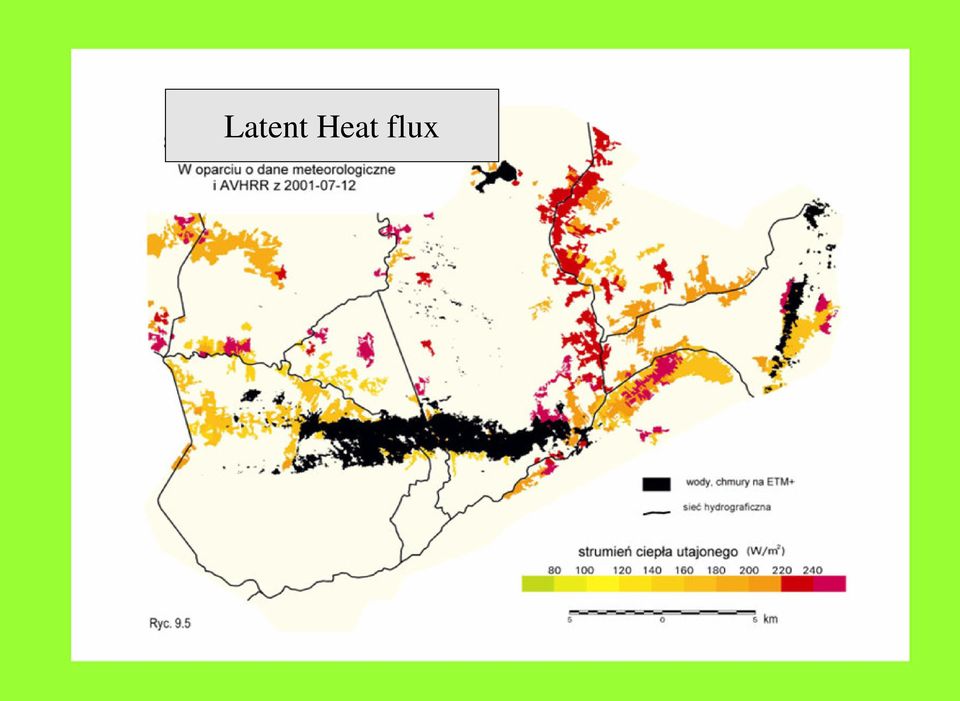
20 Latent Heat flux
21 LE [W/m2] GRASS MEADOWS, 2-PASTURES AND MEADOWS WITH SEDGE, 3-SEDGE-CANARY-GRASS MEADOWS, 4-GRASS AND HERBACEOUS MEADOWS, 5-SEDGE-GRASS MEADOWS, 6- MARCH SEDGE MEADOWS LE i = RN i E D RN D LE i E D = RNi RN D
22 Daily Evapotranspiration
23 Daily Evapotranspiration
24 σ 0 = σ v0 + τ 2 σ s 0 Grassland classes LAI (GEMI, NDVI...) Soil moisture Vegetation impact expressed by indices Soil moisture using new derived index IW = σ a σ w σ s σ s
25 Changes in humidity on in relation to (based on ERS2-SAR data)
26 Changes in humidity on in relation to (based on ERS2-SAR data)
27
28 Average backscattering coefficient in each land use class calculated from ERS-2. SAR
29 NDVI index from Landsat ETM NDVI index from Landsat ETM
30 Opady (mm) suma opadów (mm) stycze luty marzec kw iecie maj czerw iec lipiec sierpie w rzesie miesic/dekada
31 Backscattering coefficient from ERS.2 SAR
32 NDVI for grassland classes using ERS2.SAR
33 Average values of NDVI for grassland classes using Landsat ETM
34 Average values of backscattering coefficient for grassland classes using ERS2.SAR
35 Flooded Areas
36 ENVISAT ASAR OSOWIEC OSOWIEC WIZNA WIZNA
37
38
39 MERIS IMAGE from
40
Monitoring Soil Moisture from Space. Dr. Heather McNairn Science and Technology Branch Agriculture and Agri-Food Canada [email protected].
 Monitoring Soil Moisture from Space Dr. Heather McNairn Science and Technology Branch Agriculture and Agri-Food Canada [email protected] What is Remote Sensing? Scientists turn the raw data collected
Spectral Response for DigitalGlobe Earth Imaging Instruments
 Spectral Response for DigitalGlobe Earth Imaging Instruments IKONOS The IKONOS satellite carries a high resolution panchromatic band covering most of the silicon response and four lower resolution spectral
Selecting the appropriate band combination for an RGB image using Landsat imagery
 Selecting the appropriate band combination for an RGB image using Landsat imagery Ned Horning Version: 1.0 Creation Date: 2004-01-01 Revision Date: 2004-01-01 License: This document is licensed under a
Land Use/Land Cover Map of the Central Facility of ARM in the Southern Great Plains Site Using DOE s Multi-Spectral Thermal Imager Satellite Images
 Land Use/Land Cover Map of the Central Facility of ARM in the Southern Great Plains Site Using DOE s Multi-Spectral Thermal Imager Satellite Images S. E. Báez Cazull Pre-Service Teacher Program University
Overview. What is EMR? Electromagnetic Radiation (EMR) LA502 Special Studies Remote Sensing
 LA502 Special Studies Remote Sensing") LA502 Special Studies Remote Sensing Electromagnetic Radiation (EMR) Dr. Ragab Khalil Department of Landscape Architecture Faculty of Environmental Design King AbdulAziz University Room 103 Overview What
LA502 Special Studies Remote Sensing Electromagnetic Radiation (EMR) Dr. Ragab Khalil Department of Landscape Architecture Faculty of Environmental Design King AbdulAziz University Room 103 Overview What
APPLICATION OF TERRA/ASTER DATA ON AGRICULTURE LAND MAPPING. Genya SAITO*, Naoki ISHITSUKA*, Yoneharu MATANO**, and Masatane KATO***
 APPLICATION OF TERRA/ASTER DATA ON AGRICULTURE LAND MAPPING Genya SAITO*, Naoki ISHITSUKA*, Yoneharu MATANO**, and Masatane KATO*** *National Institute for Agro-Environmental Sciences 3-1-3 Kannondai Tsukuba
Using Remote Sensing to Monitor Soil Carbon Sequestration
 Using Remote Sensing to Monitor Soil Carbon Sequestration E. Raymond Hunt, Jr. USDA-ARS Hydrology and Remote Sensing Beltsville Agricultural Research Center Beltsville, Maryland Introduction and Overview
WATER BODY EXTRACTION FROM MULTI SPECTRAL IMAGE BY SPECTRAL PATTERN ANALYSIS
 WATER BODY EXTRACTION FROM MULTI SPECTRAL IMAGE BY SPECTRAL PATTERN ANALYSIS Nguyen Dinh Duong Department of Environmental Information Study and Analysis, Institute of Geography, 18 Hoang Quoc Viet Rd.,
Review for Introduction to Remote Sensing: Science Concepts and Technology
 Review for Introduction to Remote Sensing: Science Concepts and Technology Ann Johnson Associate Director [email protected] Funded by National Science Foundation Advanced Technological Education program [DUE
Monitoring a Changing Environment with Synthetic Aperture Radar. Alaska Satellite Facility National Park Service Don Atwood
 Monitoring a Changing Environment with Synthetic Aperture Radar Don Atwood Alaska Satellite Facility 1 Entering the SAR Age 2 SAR Satellites RADARSAT-1 Launched 1995 by CSA 5.6 cm (C-Band) HH Polarization
Geography 403 Lecture 7 Scanners, Thermal, and Microwave
 Geography 403 Lecture 7 Scanners, Thermal, and Microwave Needs: Lect_403_7.ppt A. Basics of Passive Electric Sensors 1. Sensors absorb EMR and produce some sort of response, such as voltages differences
Measurement of the effect of biomass burning aerosol on inhibition of cloud formation over the Amazon
 Supporting Online Material for Koren et al. Measurement of the effect of biomass burning aerosol on inhibition of cloud formation over the Amazon 1. MODIS new cloud detection algorithm The operational
The use of Earth Observation technology to support the implementation of the Ramsar Convention
 Wetlands: water, life, and culture 8th Meeting of the Conference of the Contracting Parties to the Convention on Wetlands (Ramsar, Iran, 1971) Valencia, Spain, 18-26 November 2002 COP8 DOC. 35 Information
European Space Agency EO Missions. Ola Gråbak ESA Earth Observation Programmes Tromsø, 17 October 2012
 European Space Agency EO Missions Ola Gråbak ESA Earth Observation Programmes Tromsø, 17 October 2012 Europe and Space, A POLICY Article 189 of the Lisbon Treaty (2009) gives the European Union an explicit
Asia-Pacific Environmental Innovation Strategy (APEIS)
") Asia-Pacific Environmental Innovation Strategy (APEIS) Integrated Environmental Monitoring IEM) Dust Storm Over-cultivation Desertification Urbanization Floods Deforestation Masataka WATANABE, National
Asia-Pacific Environmental Innovation Strategy (APEIS) Integrated Environmental Monitoring IEM) Dust Storm Over-cultivation Desertification Urbanization Floods Deforestation Masataka WATANABE, National
1. Theoretical background
 1. Theoretical background We consider the energy budget at the soil surface (equation 1). Energy flux components absorbed or emitted by the soil surface are: net radiation, latent heat flux, sensible heat
River Flood Damage Assessment using IKONOS images, Segmentation Algorithms & Flood Simulation Models
 River Flood Damage Assessment using IKONOS images, Segmentation Algorithms & Flood Simulation Models Steven M. de Jong & Raymond Sluiter Utrecht University Corné van der Sande Netherlands Earth Observation
Remote Sensing Satellite Information Sheets Geophysical Institute University of Alaska Fairbanks
 Remote Sensing Satellite Information Sheets Geophysical Institute University of Alaska Fairbanks ASTER Advanced Spaceborne Thermal Emission and Reflection Radiometer AVHRR Advanced Very High Resolution
Global environmental information Examples of EIS Data sets and applications
 METIER Graduate Training Course n 2 Montpellier - february 2007 Information Management in Environmental Sciences Global environmental information Examples of EIS Data sets and applications Global datasets
A remote sensing instrument collects information about an object or phenomenon within the
 Satellite Remote Sensing GE 4150- Natural Hazards Some slides taken from Ann Maclean: Introduction to Digital Image Processing Remote Sensing the art, science, and technology of obtaining reliable information
Development of Method for LST (Land Surface Temperature) Detection Using Big Data of Landsat TM Images and AWS
 Detection Using Big Data of Landsat TM Images and AWS") Development of Method for LST (Land Surface Temperature) Detection Using Big Data of Landsat TM Images and AWS Myung-Hee Jo¹, Sung Jae Kim², Jin-Ho Lee 3 ¹ Department of Aeronautical Satellite System Engineering,
Development of Method for LST (Land Surface Temperature) Detection Using Big Data of Landsat TM Images and AWS Myung-Hee Jo¹, Sung Jae Kim², Jin-Ho Lee 3 ¹ Department of Aeronautical Satellite System Engineering,
SAMPLE MIDTERM QUESTIONS
 Geography 309 Sample MidTerm Questions Page 1 SAMPLE MIDTERM QUESTIONS Textbook Questions Chapter 1 Questions 4, 5, 6, Chapter 2 Questions 4, 7, 10 Chapter 4 Questions 8, 9 Chapter 10 Questions 1, 4, 7
Proba-V: Earthwatch Mission as part of ESA s Earth Observation Programmes
 Proba-V: Earthwatch Mission as part of ESA s Earth Observation Programmes Antwerp 05.07.2013 Bianca Hoersch Proba-V Mission Manager Third Party Mission & Sentinel-2 Mission Manager Earth Observation Directorate,
Earth remote sensing systems of middle and low resolution
 Earth remote sensing systems of middle and low resolution Serial on-line remote sensing satellites delivering data available on the world market V.I. Gershenzon (ScanEx R&D Center) In 1980, graduated from
Resolutions of Remote Sensing
 Resolutions of Remote Sensing 1. Spatial (what area and how detailed) 2. Spectral (what colors bands) 3. Temporal (time of day/season/year) 4. Radiometric (color depth) Spatial Resolution describes how
Radiation Transfer in Environmental Science
 Radiation Transfer in Environmental Science with emphasis on aquatic and vegetation canopy media Autumn 2008 Prof. Emmanuel Boss, Dr. Eyal Rotenberg Introduction Radiation in Environmental sciences Most
Remote Sensing. Vandaag. Voordelen Remote Sensing Wat is Remote Sensing? Vier elementen Remote Sensing systeem
 Remote Sensing 1 Vandaag Voordelen Remote Sensing Wat is Remote Sensing? Vier elementen Remote Sensing systeem 2 Nederland Vanaf 700 km hoogte Landsat TM mozaïek 3 Europa vanaf 36000 km hoogte 4 5 Mount
High Resolution Information from Seven Years of ASTER Data
 High Resolution Information from Seven Years of ASTER Data Anna Colvin Michigan Technological University Department of Geological and Mining Engineering and Sciences Outline Part I ASTER mission Terra
Using Remote Sensing Imagery to Evaluate Post-Wildfire Damage in Southern California
 Graham Emde GEOG 3230 Advanced Remote Sensing February 22, 2013 Lab #1 Using Remote Sensing Imagery to Evaluate Post-Wildfire Damage in Southern California Introduction Wildfires are a common disturbance
Remote sensing and management of large irrigation projects
 Remote sensing and management of large irrigation projects Lahlou O., Vidal A. in Deshayes M. (ed.). La télédétection en agriculture Montpellier : CIHEAM Options Méditerranéennes : Série A. Séminaires
Active and Passive Microwave Remote Sensing
 Active and Passive Microwave Remote Sensing Passive remote sensing system record EMR that was reflected (e.g., blue, green, red, and near IR) or emitted (e.g., thermal IR) from the surface of the Earth.
Mapping Earth from Space Remote sensing and satellite images. Remote sensing developments from war
 Mapping Earth from Space Remote sensing and satellite images Geomatics includes all the following spatial technologies: a. Cartography "The art, science and technology of making maps" b. Geographic Information
Electromagnetic Radiation (EMR) and Remote Sensing
 and Remote Sensing") Electromagnetic Radiation (EMR) and Remote Sensing 1 Atmosphere Anything missing in between? Electromagnetic Radiation (EMR) is radiated by atomic particles at the source (the Sun), propagates through
Electromagnetic Radiation (EMR) and Remote Sensing 1 Atmosphere Anything missing in between? Electromagnetic Radiation (EMR) is radiated by atomic particles at the source (the Sun), propagates through
Preface. Ko Ko Lwin Division of Spatial Information Science University of Tsukuba 2008
 1 Preface Remote Sensing data is one of the primary data sources in GIS analysis. The objective of this material is to provide fundamentals of Remote Sensing technology and its applications in Geographical
Passive Remote Sensing of Clouds from Airborne Platforms
 Passive Remote Sensing of Clouds from Airborne Platforms Why airborne measurements? My instrument: the Solar Spectral Flux Radiometer (SSFR) Some spectrometry/radiometry basics How can we infer cloud properties
D.S. Boyd School of Earth Sciences and Geography, Kingston University, U.K.
 PHYSICAL BASIS OF REMOTE SENSING D.S. Boyd School of Earth Sciences and Geography, Kingston University, U.K. Keywords: Remote sensing, electromagnetic radiation, wavelengths, target, atmosphere, sensor,
How To Find Natural Oil Seepage In The Dreki Area Using An Envisat Image
 rn ORKUSTOFNUN National Energy Authority Searching for natural oil seepage in the Dreki area using ENVISAT radar images. Ingibjorg J6nsd6ttir and Arni Freyr Valdimarsson, Faculty of Earth Sciences School
Sentinel-1 Mission Overview
 Sentinel-1 Mission Overview Pierre Potin Sentinel-1 Mission Manager, ESA Advanced Course on Radar Polarimetry ESRIN, Frascati, 19 January 2011 Global Monitoring for Environment and Security GMES is established
RADIATION IN THE TROPICAL ATMOSPHERE and the SAHEL SURFACE HEAT BALANCE. Peter J. Lamb. Cooperative Institute for Mesoscale Meteorological Studies
 RADIATION IN THE TROPICAL ATMOSPHERE and the SAHEL SURFACE HEAT BALANCE by Peter J. Lamb Cooperative Institute for Mesoscale Meteorological Studies and School of Meteorology The University of Oklahoma
Monsoon Variability and Extreme Weather Events
 Monsoon Variability and Extreme Weather Events M Rajeevan National Climate Centre India Meteorological Department Pune 411 005 [email protected] Outline of the presentation Monsoon rainfall Variability
Lectures Remote Sensing
 Lectures Remote Sensing ATMOSPHERIC CORRECTION dr.ir. Jan Clevers Centre of Geo-Information Environmental Sciences Wageningen UR Atmospheric Correction of Optical RS Data Background When needed? Model
SatelliteRemoteSensing for Precision Agriculture
 SatelliteRemoteSensing for Precision Agriculture Managing Director WasatSp. z o.o. Copernicus the road to economic development Warsaw, 26-27 February 2015 Activitiesof WasatSp. z o.o. The company provides
Overview of NASA Applied Remote Sensing Training Program on Water Resources and Disaster Management
 Overview of NASA Applied Remote Sensing Training Program on Water Resources and Disaster Management ARSET Applied Remote SEnsing Training A project of NASA Applied Sciences Outline About ARSET ARSET Trainings
MODIS IMAGES RESTORATION FOR VNIR BANDS ON FIRE SMOKE AFFECTED AREA
 MODIS IMAGES RESTORATION FOR VNIR BANDS ON FIRE SMOKE AFFECTED AREA Li-Yu Chang and Chi-Farn Chen Center for Space and Remote Sensing Research, National Central University, No. 300, Zhongda Rd., Zhongli
Treasure Hunt. Lecture 2 How does Light Interact with the Environment? EMR Principles and Properties. EMR and Remote Sensing
 Lecture 2 How does Light Interact with the Environment? Treasure Hunt Find and scan all 11 QR codes Choose one to watch / read in detail Post the key points as a reaction to http://www.scoop.it/t/env202-502-w2
16 th IOCCG Committee annual meeting. Plymouth, UK 15 17 February 2011. mission: Present status and near future
 16 th IOCCG Committee annual meeting Plymouth, UK 15 17 February 2011 The Meteor 3M Mt satellite mission: Present status and near future plans MISSION AIMS Satellites of the series METEOR M M are purposed
Titelmasterformat durch Klicken. bearbeiten
 Evaluation of a Fully Coupled Atmospheric Hydrological Modeling System for the Sissili Watershed in the West African Sudanian Savannah Titelmasterformat durch Klicken June, 11, 2014 1 st European Fully
Limitations of Equilibrium Or: What if τ LS τ adj?
 Limitations of Equilibrium Or: What if τ LS τ adj? Bob Plant, Laura Davies Department of Meteorology, University of Reading, UK With thanks to: Steve Derbyshire, Alan Grant, Steve Woolnough and Jeff Chagnon
SEMI-AUTOMATED CLOUD/SHADOW REMOVAL AND LAND COVER CHANGE DETECTION USING SATELLITE IMAGERY
 SEMI-AUTOMATED CLOUD/SHADOW REMOVAL AND LAND COVER CHANGE DETECTION USING SATELLITE IMAGERY A. K. Sah a, *, B. P. Sah a, K. Honji a, N. Kubo a, S. Senthil a a PASCO Corporation, 1-1-2 Higashiyama, Meguro-ku,
Remote sensing and GIS applications in coastal zone monitoring
 Remote sensing and GIS applications in coastal zone monitoring T. Alexandridis, C. Topaloglou, S. Monachou, G.Tsakoumis, A. Dimitrakos, D. Stavridou Lab of Remote Sensing and GIS School of Agriculture
dynamic vegetation model to a semi-arid
 Application of a conceptual distributed dynamic vegetation model to a semi-arid basin, SE of Spain By: M. Pasquato, C. Medici and F. Francés Universidad Politécnica de Valencia - Spain Research Institute
How does snow melt? Principles of snow melt. Energy balance. GEO4430 snow hydrology 21.03.2006. Energy flux onto a unit surface:
 Principles of snow melt How does snow melt? We need energy to melt snow/ ice. GEO443 snow hydrology 21.3.26 E = m L h we s K = ρ h = w w we f E ρ L L f f Thomas V. Schuler [email protected] E energy
Remote Sensing an Introduction
 Remote Sensing an Introduction Seminar: Space is the Place Referenten: Anica Huck & Michael Schlund Remote Sensing means the observation of, or gathering information about, a target by a device separated
How to calculate reflectance and temperature using ASTER data
 How to calculate reflectance and temperature using ASTER data Prepared by Abduwasit Ghulam Center for Environmental Sciences at Saint Louis University September, 2009 This instructions walk you through
Developing Continuous SCM/CRM Forcing Using NWP Products Constrained by ARM Observations
 Developing Continuous SCM/CRM Forcing Using NWP Products Constrained by ARM Observations S. C. Xie, R. T. Cederwall, and J. J. Yio Lawrence Livermore National Laboratory Livermore, California M. H. Zhang
Monitoring of Arctic Conditions from a Virtual Constellation of Synthetic Aperture Radar Satellites
 DISTRIBUTION STATEMENT A. Approved for public release; distribution is unlimited. Monitoring of Arctic Conditions from a Virtual Constellation of Synthetic Aperture Radar Satellites Hans C. Graber RSMAS
1 The interaction of visible and near infrared EMR with soil
 PROPERTIES OF EARTH SURFACES AND THEIR INTERACTIONS WITH ELECTROMAGNETIC RADIATION AT VISIBLE AND NEAR INFRARED WAVELENGTHS For a fixed distribution of incident radiation, the particular properties of
Monitoring Overview with a Focus on Land Use Sustainability Metrics
 Monitoring Overview with a Focus on Land Use Sustainability Metrics Canadian Roundtable for Sustainable Crops. Nov 26, 2014 Agriclimate, Geomatics, and Earth Observation Division (ACGEO). Presentation
Microwave observations in the presence of cloud and precipitation
 Microwave observations in the presence of cloud and precipitation Alan Geer Thanks to: Bill Bell, Peter Bauer, Fabrizio Baordo, Niels Bormann Slide 1 ECMWF/EUMETSAT satellite course 2015: Microwave 2 Slide
Soil degradation monitoring by active and passive remote-sensing means: examples with two degradation processes
 Soil degradation monitoring by active and passive remote-sensing means: examples with two degradation processes Naftaly Goldshleger, *Eyal Ben-Dor,* *Ido Livne,* U. Basson***, and R.Ben-Binyamin*Vladimir
Christine E. Hatch University of Nevada, Reno
 Christine E. Hatch University of Nevada, Reno Roadmap What is DTS? How Does it Work? What Can DTS Measure? Applications What is Distributed Temperature Sensing (DTS)? Temperature measurement using only
Potential of Sugar cane monitoring using Synthetic Aperture Radar in Central Thailand
 Potential of Sugar cane monitoring using Synthetic Aperture Radar in Central Thailand Thanit Intarat 1, Preesan Rakwatin 1, Panu Srestasathien 1, Peeteenut Triwong 2, Chanwit Tangsiriworakul 2, and Samart
2 Absorbing Solar Energy
 2 Absorbing Solar Energy 2.1 Air Mass and the Solar Spectrum Now that we have introduced the solar cell, it is time to introduce the source of the energy the sun. The sun has many properties that could
Calculation of Minimum Distances. Minimum Distance to Means. Σi i = 1
 Minimum Distance to Means Similar to Parallelepiped classifier, but instead of bounding areas, the user supplies spectral class means in n-dimensional space and the algorithm calculates the distance between
ANALYSIS OF FOREST CHANGE IN FIRE DAMAGE AREA USING SATELLITE IMAGES
 ANALYSIS OF FOREST CHANGE IN FIRE DAMAGE AREA USING SATELLITE IMAGES Joon Mook Kang, Professor Joon Kyu Park, Ph.D Min Gyu Kim, Ph.D._Candidate Dept of Civil Engineering, Chungnam National University 220
Energy Pathways in Earth s Atmosphere
 BRSP - 10 Page 1 Solar radiation reaching Earth s atmosphere includes a wide spectrum of wavelengths. In addition to visible light there is radiation of higher energy and shorter wavelength called ultraviolet
The study of cloud and aerosol properties during CalNex using newly developed spectral methods
 The study of cloud and aerosol properties during CalNex using newly developed spectral methods Patrick J. McBride, Samuel LeBlanc, K. Sebastian Schmidt, Peter Pilewskie University of Colorado, ATOC/LASP
Landsat Monitoring our Earth s Condition for over 40 years
 Landsat Monitoring our Earth s Condition for over 40 years Thomas Cecere Land Remote Sensing Program USGS ISPRS:Earth Observing Data and Tools for Health Studies Arlington, VA August 28, 2013 U.S. Department
Soil Moisture Estimation Using Active DTS at MOISST Site
 MOISST Workhsop, 2014 Soil Moisture Estimation Using Active DTS at MOISST Site June 4, 2014 Chadi Sayde, Daniel Moreno, John Selker Department of Biological and Ecological Engineering Oregon State University,
RESULTS FROM A SIMPLE INFRARED CLOUD DETECTOR
 RESULTS FROM A SIMPLE INFRARED CLOUD DETECTOR A. Maghrabi 1 and R. Clay 2 1 Institute of Astronomical and Geophysical Research, King Abdulaziz City For Science and Technology, P.O. Box 6086 Riyadh 11442,
Satellite Monitoring of Urbanization in Megacities
 Satellite Monitoring of Urbanization in Megacities Yifang Ban Professor of Geoinformatics Department of Urban Planning & Environment KTH Royal Institute of Technology Stockholm, Sweden Introduction In
The NASA NEESPI Data Portal to Support Studies of Climate and Environmental Changes in Non-boreal Europe
 The NASA NEESPI Data Portal to Support Studies of Climate and Environmental Changes in Non-boreal Europe Suhung Shen NASA Goddard Space Flight Center/George Mason University Gregory Leptoukh, Tatiana Loboda,
Monitoring top soil moisture through remote sensing to aid hydrologic modelling
 Monitoring top soil moisture through remote sensing to aid hydrologic modelling N. Verhoest 1, H. Lievens 1, L. Hoffmann 2, P. Matgen 2, M. Montanari 2, M. Vanclooster 3, S. Lambot 3, J. Minet 3, B. De
Climatology and Monitoring of Dust and Sand Storms in the Arabian Peninsula
 Climatology and Monitoring of Dust and Sand Storms in the Arabian Peninsula Mansour Almazroui Center of Excellence for Climate Change Research (CECCR) King Abdulaziz University, Jeddah, Saudi Arabia E-mail:
Satellite Snow Monitoring Activities Project CRYOLAND
 Satellite Snow Monitoring Activities Project CRYOLAND Background material for participants to the Workshop on European Snow Monitoring Perspectives, Darmstadt, 4-5 December 2012. CryoLand provides Snow,
Lecture Series in Water, Soil and Atmosphere (315.340) Unit 1: Interaction Soil / Vegetation / Atmosphere
 Unit 1: Interaction Soil / Vegetation / Atmosphere") Dept. Water, Soil & Atmosphere Institute of Hydraulics and Rural Water Management University of Natural Resources and Life Sciences Vienna Lecture Series in Water, Soil and Atmosphere (315.340) Unit 1:
Dept. Water, Soil & Atmosphere Institute of Hydraulics and Rural Water Management University of Natural Resources and Life Sciences Vienna Lecture Series in Water, Soil and Atmosphere (315.340) Unit 1:
Fundamentals of Climate Change (PCC 587): Water Vapor
: Water Vapor") Fundamentals of Climate Change (PCC 587): Water Vapor DARGAN M. W. FRIERSON UNIVERSITY OF WASHINGTON, DEPARTMENT OF ATMOSPHERIC SCIENCES DAY 2: 9/30/13 Water Water is a remarkable molecule Water vapor
Fundamentals of Climate Change (PCC 587): Water Vapor DARGAN M. W. FRIERSON UNIVERSITY OF WASHINGTON, DEPARTMENT OF ATMOSPHERIC SCIENCES DAY 2: 9/30/13 Water Water is a remarkable molecule Water vapor
Global land cover mapping: conceptual and historical background
 Space Research Institute Russian Academy of Sciences Global land cover mapping: conceptual and historical background Sergey BARTALEV with acknowledged contribution from: Etienne Bartholomé and Philippe
Two primary advantages of radars: all-weather and day /night imaging
 Lecture 0 Principles of active remote sensing: Radars. Objectives: 1. Radar basics. Main types of radars.. Basic antenna parameters. Required reading: G: 8.1, p.401-40 dditional/advanced reading: Online
Remote sensing study on the Pisa plain
 Remote sensing study on the Pisa plain Bini M., Kukavicic M., Pappalardo M. MapPapers 5en-II, 2012, pp.201-211 doi:10.4456/mappa.2012.34 Multispectral images with medium-high resolution were acquired from
Welcome to NASA Applied Remote Sensing Training (ARSET) Webinar Series
 Webinar Series") Welcome to NASA Applied Remote Sensing Training (ARSET) Webinar Series Introduction to Remote Sensing Data for Water Resources Management Course Dates: October 17, 24, 31 November 7, 14 Time: 8-9 a.m.
Welcome to NASA Applied Remote Sensing Training (ARSET) Webinar Series Introduction to Remote Sensing Data for Water Resources Management Course Dates: October 17, 24, 31 November 7, 14 Time: 8-9 a.m.
Persistent Scatterer Interferometry and Cosmo-SkyMed data in the Piano Straordianario di Telerilevamento Ambientale (PST-A) Salvatore Costabile
 Salvatore Costabile") Persistent Scatterer Interferometry and Cosmo-SkyMed data in the Piano Straordianario di Telerilevamento Ambientale (PST-A) Salvatore Costabile E-GEOS Conference 2012 23-24 May, Rome (Italy) Summary PST-A:
Persistent Scatterer Interferometry and Cosmo-SkyMed data in the Piano Straordianario di Telerilevamento Ambientale (PST-A) Salvatore Costabile E-GEOS Conference 2012 23-24 May, Rome (Italy) Summary PST-A:
Введение в спутниковую радиолокацию: Радиолокаторы с синтезированной апертурой (РСА) Introduction to satellite radars: Synthetic Aperture Radars (SAR)
 Introduction to satellite radars: Synthetic Aperture Radars (SAR)") Введение в спутниковую радиолокацию: Радиолокаторы с синтезированной апертурой (РСА) Introduction to satellite radars: Synthetic Aperture Radars (SAR) проф. Бертран Шапрон IFREMER / ЛСО РГГМУ Prof. Bertrand
Введение в спутниковую радиолокацию: Радиолокаторы с синтезированной апертурой (РСА) Introduction to satellite radars: Synthetic Aperture Radars (SAR) проф. Бертран Шапрон IFREMER / ЛСО РГГМУ Prof. Bertrand
Hyperspectral Satellite Imaging Planning a Mission
 Hyperspectral Satellite Imaging Planning a Mission Victor Gardner University of Maryland 2007 AIAA Region 1 Mid-Atlantic Student Conference National Institute of Aerospace, Langley, VA Outline Objective
Land Cover Change and Fire Damage Monitoring using ERS-1/2 SAR multi-temporal data sets in East-Kalimantan, Indonesia 1
 Land Cover Change and Fire Damage Monitoring using ERS-1/2 SAR multi-temporal data sets in East-Kalimantan, Indonesia 1 Ruandha Agung Sugardiman Department of Environmental Sciences Sub-department of Water
Data processing (3) Cloud and Aerosol Imager (CAI)
 Cloud and Aerosol Imager (CAI)") Data processing (3) Cloud and Aerosol Imager (CAI) 1) Nobuyuki Kikuchi, 2) Haruma Ishida, 2) Takashi Nakajima, 3) Satoru Fukuda, 3) Nick Schutgens, 3) Teruyuki Nakajima 1) National Institute for Environmental
Data processing (3) Cloud and Aerosol Imager (CAI) 1) Nobuyuki Kikuchi, 2) Haruma Ishida, 2) Takashi Nakajima, 3) Satoru Fukuda, 3) Nick Schutgens, 3) Teruyuki Nakajima 1) National Institute for Environmental
Satellites for Terrain Motion Mapping Terrafirma User Workshop Mining. Nico Adam
 Satellites for Terrain Motion Mapping Terrafirma User Workshop Mining Nico Adam Outline SAR / InSAR observation characteristic Sensors TSX, TDX ERS-1, ERS-2 Processing techniques D-InSAR PSI SBAS Acquisition
Physics PH1FP. (Jun15PH1FP01) General Certificate of Secondary Education Foundation Tier June 2015. Unit Physics P1. Unit Physics P1 TOTAL
 General Certificate of Secondary Education Foundation Tier June 2015. Unit Physics P1. Unit Physics P1 TOTAL") Centre Number Surname Candidate Number For Examiner s Use Other Names Candidate Signature Examiner s Initials Question Mark Science A Unit Physics P1 Physics Unit Physics P1 Friday 12 June 2015 General
Centre Number Surname Candidate Number For Examiner s Use Other Names Candidate Signature Examiner s Initials Question Mark Science A Unit Physics P1 Physics Unit Physics P1 Friday 12 June 2015 General