DESKTOP WEB MOBILE. Building on ArcGIS from GIS Industry Leader, Esri
|
|
|
- Merry Powers
- 8 years ago
- Views:
Transcription
1
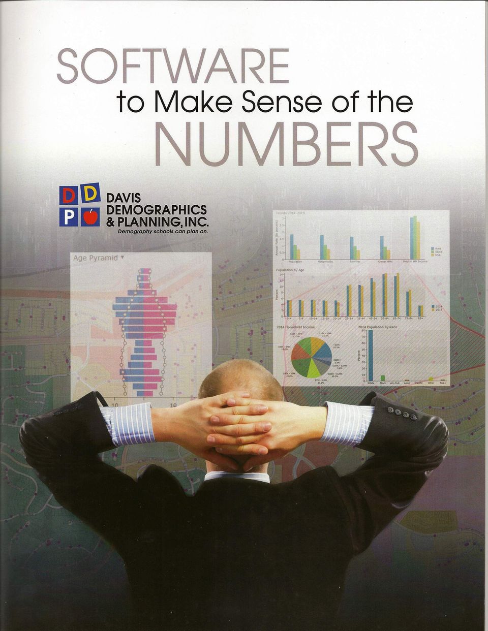
2 Building on ArcGIS from GIS Industry Leader, Esri Esri is the industry leader and standard for advancing GIS through the world. Close to 90 percent of all counties in the U.S. and Fortune 500 companies use ArcGIS and Esri mapping technology to make better decisions. As an Esri software user and award-winning Business Partner for over 20 years, DDP is known within Esri GIS circles as the go-to firm for school district planning, consulting, and implementation. SchoolSite Planning Suite Powerful desktop extensions to Esri ArcGIS software include: Flexible modelling of both short-term and longterm enrollment forecasting Extensive attendance boundary simulation and reporting tools Comprehensive spatial tools for efficiency analysis of District operations Professional map making and publishing tools Data sharing and collaboration tools for District departments and presentations to the public Access any area for population infographics Leading Edge Software for Planning, Collaboration and Communication Our GIS mapping software applications, used in all of our daily consulting work, are the most powerful and comprehensive set of analysis, decision-making and collaboration tools available. They have earned DDP numerous awards in the industry and are used in over 200 districts in North America. DESKTOP WEB MOBILE Maps for Microsoft Office Make dynamic maps of your spreadsheet data right in Excel. Visualize your student data in a variety of ways including cluster and heat maps. Share your maps and data with other District staff. Embed live maps into your PowerPoint presentations. SchoolSite Locator Web-based school choice information tools for staff and parents: Address-to-school assignment School site information Attendance boundary maps Driving directions to schools Many other features ArcGIS Online Cloud-based SaaS for making and sharing maps, demographic data, facility information and other geographic data and content with District staff, District departments and the community. DDP School Web Applications for Online Planning DDP is an approved ArcGIS Marketplace Provider offering school district access to a variety of demographic reporting, student analysis and mapping applications through the web. Efficient and timely access to information for those who need to know

3 Progressive Technology You Can Use It was over 30 years ago that DDP understood the impact of geographic information system (GIS) technologies and how these tools would benefit the efforts of long-range planning and administration of public school districts. Esri, the industry leader and standard for advancing GIS throughout the world, invited DDP to be a Business Partner over 20 years ago. In fact, DDP is known within Esri GIS circles as the go to firm for school district planning, consulting and implementation. Our refinement and ongoing enhancement of our various software programs keep you ahead of the curve with groundbreaking tools. DDP s advanced software combined with a pledge to superior training, ensures you can successfully use and interpret planning data for your communities.

4 As an early adopter of GIS technology, DDP has worked with Esri since the mid-1980s delivering many of the first school administrative demographic and planning applications. SchoolSite for ArcGIS illustrates the continuing commitment that DDP has given to providing K-12 school administrators with the most up-to-date planning solutions based upon Esri technology Jack Dangermond Esri President/Founder SchoolSite for ArcGIS Master Plan Your School District From Your Desktop Davis Demographics SchoolSite for ArcGIS is a geographic information system (GIS) application for school districts based upon leading-edge mapping technology used by thousands of businesses and organizations. GIS links your school district data to intelligent maps, which provides an extraordinary ability to visualize the demographics of your district and strategically plan for the future using a variety of mapping tools. Offered as extensions to industry-standard ArcGIS mapping software, SchoolSite is designed specifically to solve a wide variety of issues that districts have to constantly address during the planning process. With the SchoolSite Redistricting Extension for ArcGIS, districts can analyze and report on any data about their students, modify attendance boundaries and create updated maps and demographic reports. The SchoolSite Projection Extension provides comprehensive forecasting tools using a highly accurate proven model to predict short and long-term future enrollment. These forecasts are automatically integrated into the Redistricting Extension for determining future site needs, analyzing the opening and/or closing of school sites, and providing an unlimited number of potential future attendance boundary scenarios. And SchoolSite works seamlessly with ArcGIS Online to web-enable your maps and communicate your results to district staff, departments and the public. SchoolSite can assist in finding answers to the many difficult planning questions facing your school district, and to visually present the results in an easily understood way.

5 Redistricting Extension Attendance Boundary Planning and Reports/Facility Siting Tools Powerful SchoolSite redistricting tools can help adjust attendance boundaries, simulate grade reconfigurations, generate a variety of reports, and help locate the need for new facilities. The SchoolSite Redistricting Extension for ArcGIS provides a user friendly wizard-based method to create and modify an unlimited number of attendance boundary plans along with associated demographic reports. Boundary plans are based upon the interactive reassignment of building blocks of small planning/study areas using current or forecasted student populations. In addition to using current attendance boundaries, initial plans can be developed using one of several methods: assign study areas to closest school, assign to closest school assuming equal school capacity, or assign to closest school based upon individual school capacity. Study areas can be individually reassigned to various schools to balance enrollment to site capacities. Additional sites can be added or existing sites deleted simulating the opening or closing of schools. As boundaries are modified, changes in student demographics are automatically reflected in various tables. Additional population and socio-economic statistics for each boundary can be obtained using online demographic data and reports. Boundary plans can be immediately published as live maps on the web for sharing internally with district staff and/or the community. Key Functions Added to ArcGIS : Enhanced student geocoding/mapping tools Unlimited boundary plans through the interactive assignment of user-defined study areas Comprehensive reporting capabilities including counts and percentages of students by grade level, multiple grade groupings, special programs, schools of enrollment or other data fields (complete flexibility in loading and using student data) Export student statistic reports to Excel Street Directory lists with address ranges and schools of assignment Boundary planning using choice of current residing students or forecasted resident students Open enrollment impact reports including rules-based boundary planning to estimate actual school enrollment SchoolSite includes our proven student forecasting model integrated into ArcGIS for visualization of future trends. Key Functions Added to ArcGIS : Enrollment Forecasting Extension Future Enrollment Estimating Tools The Enrollment Forecasting Extension includes an accurate and proven projection model integrated within ArcGIS for developing short and long-range student forecasts. The forecasts are accessible within the Redistricting Extension for powerful forward-thinking boundary planning and site location analysis. Create an unlimited number of enrollment forecast scenarios using what-if analysis of various model inputs Auto-run of the projection model guarantees projections are always in-sync with user changes to projection variables User update of projection variables through spreadsheet type interface Auto-determination of cohort/mobility factors using historical student data Optional development map layer and timing of new construction projects automatically incorporated in the projections Projections developed for each year up to ten years plus optional district build-out for long-range site studies Projection reports at each level of geography including study area, attendance zone, user-defined regions and districtwide Reports can incorporate multiple grade groupings to simulate impact of grade reconfigurations Dynamically display enrollment projections through color-coded maps labelled with forecasted students Enrollment projections are automatically linked with redistricting plans to simulate the impact on attendance boundaries if forecasts are modified

6 Extensive demographic reporting is available in all of our software applications on the desktop and the web. Software That Empowers Decision-Making Parcel data combined with student addresses provide sophisticated analysis of student housing generation rates Mapped student locations can be filtered and color-coded in a variety of ways based upon any student data fields.

7 Student density or heat maps can be created illustrating areas of potential enrollment impact. Map illustrating projected 9th through 12th grade student density 10 years into the future with the location of a future high school site.

8 Sophisticated software tools allow for the allocation of special education students to facilities illustrating the efficient placement of programs within the District. Origin of charter school students can be analyzed in relation to drive to school. Walk zones can be shown to maximize walk-in attendance during the attendance boundary change process.

9 Areas of attendance boundary change with identification of affected students. Extensive demographic reports on hundreds of variables are available for any geographic or user-defined areas including current year and five year estimates. SchoolSite includes our proven student forecasting model integrated into ArcGIS for visualization of future enrollment impact.

10 Davis Demographics provides extensive development research for growing districts. Housing projects are mapped and the underlying data integrated as one of many variables in a sophisticated student forecasting model. Informative maps with complete student demographics are prepared for boundary committee facilitation.

11 Maps can be created in Excel to quickly understand patterns in your data. Mapping special education students can assist in understanding best placement of programs. DDP can web-enable your District s demographic and mapping data to facilitate sharing among District departments and communicate with the public. The District s web mapping portal can easily be maintained by District staff or administered by DDP. SchoolSite Locator is one of many web services available through Davis Demographics and provides easy access to schoolof-assignment information for parents and staff. Field access and real-time collection of facility and maintenance information.

12 For nearly 30 years, DDP has been the leading demographic and planning consultant and provider of software for school districts. Our skilled experts in software development, combined with our close alliance with Esri, ensures access to leading-edge information technology and our clients can continue to be confident with their planning decisions. Corporate Office Pierce Street, Suite 200 Riverside, CA Toll Free: Phone: Texas Office 320 Decker Drive Irving, TX Toll Free: Phone: Copyright 2015 Davis Demographics and Planning, Inc. All rights reserved. DDP, SchoolSite, SchoolSite Locator, Redistricting Extension, Projection Extension are trademarks or service marks of Davis Demographics and Planning. ArcGIS, ArcGIS Online, ArcGIS Marketplace, Maps for Office are trademarks or service marks of Esri. Other companies and products or services mentioned herein may be trademarks or service marks of their respective mark owners.

ArcGISSM. Online. The Mapping Platform for Your Organization
 ArcGISSM Online The Mapping Platform for Your Organization ArcGIS Online is a cloud-based platform for making and sharing maps, apps, and other geographic data and content. Knowledge Workers Policy Makers
Esri Maps for Salesforce and Microsoft Dynamics CRM
 Esri Maps for Salesforce and Microsoft Dynamics CRM Daniel Lee, Lucy Guerra Esri UC 2014 Technical Workshop Agenda CRM and Esri Esri Maps for Demos Road Ahead Esri UC 2014 Technical Workshop Esri Maps
An Esri White Paper April 2011 Esri Business Analyst Server System Design Strategies
 An Esri White Paper April 2011 Esri Business Analyst Server System Design Strategies Esri, 380 New York St., Redlands, CA 92373-8100 USA TEL 909-793-2853 FAX 909-793-5953 E-MAIL info@esri.com WEB esri.com
Esri s Telecommunications Solutions. GIS for Telecom
 Esri s Telecommunications Solutions GIS for Telecom Enterprise GIS for Telecommunications Telecommunications companies face enormous pressure to grow revenues. Triple and quad play services are creating
GIS for Economics & Business A modernized approach to Attract & Retain Business
 GIS for Economics & Business A modernized approach to Attract & Retain Business Mai Hoa Esri Vietnam Esri LEADER LOCATION ANALYTICS Strong and Growing..Serving Our Users A Global Company 130+ Countries
IBM Cognos TM1 Executive Viewer Fast self-service analytics
 Data Sheet IBM Cognos TM1 Executive Viewer Fast self-service analytics Overview IBM Cognos TM1 Executive Viewer provides business users with selfservice, real-time, Web-based access to information from
GIS and Mapping Solutions for Developers. ESRI Developer Network (EDN SM)
") GIS and Mapping Solutions for Developers ESRI Developer Network (EDN SM) GIS and Mapping Solutions for Developers If you are a software developer looking for an effective way to bring geographic and mapping
GIS and Mapping Solutions for Developers ESRI Developer Network (EDN SM) GIS and Mapping Solutions for Developers If you are a software developer looking for an effective way to bring geographic and mapping
SCIENCE-BASED GIS SOLUTIONS. www.earthanalytic.com
 SCIENCE-BASED GIS SOLUTIONS www.earthanalytic.com Pipeline Routing, Site Selection, Cost Estimation and Risk Management Tools for Energy SmartFootprint is an extension to ArcGIS designed to assist planning,
Experience the commitment. CGI Exploration2Revenue TM Business Suite. Optimize your upstream back office
 Experience the commitment CGI Exploration2Revenue TM Business Suite Optimize your upstream back office Delivering a competitive edge Today s oil and gas companies are challenged to lower the costs of running
ArcGIS. Server. A Complete and Integrated Server GIS
 ArcGIS Server A Complete and Integrated Server GIS ArcGIS Server A Complete and Integrated Server GIS ArcGIS Server enables you to distribute maps, models, and tools to others within your organization
Reveal More Value in Your Data with Location Analytics
 Reveal More Value in Your Data with Location Analytics Brought to you compliments of: In nearly every industry, executives, managers and employees are increasingly using maps in conjunction with enterprise
How To Use Sap Business Objects For Microsoft (For Microsoft) For Microsoft (For Pax) For Pax (For Sap) For Spera) For A Business Intelligence (Bio) Solution
 For Microsoft (For Pax) For Pax (For Sap) For Spera) For A Business Intelligence (Bio) Solution") SAP BusinessObjects FOR MICROSOFT ENVIRONMENTS MAKE BETTER DECISIONS TODAY SAP Solution Brief SAP BusinessObjects Business Intelligence Solutions SAP BusinessObjects FOR MICROSOFT ENVIRONMENTS SAP BusinessObjects
SAP BusinessObjects FOR MICROSOFT ENVIRONMENTS MAKE BETTER DECISIONS TODAY SAP Solution Brief SAP BusinessObjects Business Intelligence Solutions SAP BusinessObjects FOR MICROSOFT ENVIRONMENTS SAP BusinessObjects
ProClarity Analytics Family
 ProClarity Analytics Platform 6 Product Data Sheet Accelerated understanding The ProClarity Analytics family enables organizations to centrally manage, store and deploy best practices and key performance
Embedding Maps into Microsoft Office and Microsoft SharePoint
 Embedding Maps into Microsoft Office and Microsoft SharePoint Toronto Esri Canada User Conference Tuesday, October 16, 2012 Presented By: Heather Hainsworth hhainsworth@esri.ca Agenda This seminar is designed
ESRI Business Analyst for Telecommunications
 ESRI Business Analyst for Telecommunications GIS Market Analysis Package Drive Business Results with ESRI Business Analyst ESRI Business Analyst helps you Analyze your competition: Track customer churn.
Open Data. Open Data. Share and map your data with ArcGIS. technology.
 Open Data Share and map your data with ArcGIS Open Data technology. Publishing data as map services is one of the most valuable ways to communicate and collaborate. Maps enable an immediate understanding
Esri for Logistics. Logistics Optimization through GIS
 Esri for Logistics Logistics Optimization through GIS The Geographic Approach to Logistics All over the world, Esri geographic information system (GIS) solutions are helping transportation organizations
How To Improve Gis Data Quality
 An Esri White Paper July 2011 GIS Data Quality Best Practices for Water, Wastewater, and Stormwater Utilities Esri, 380 New York St., Redlands, CA 92373-8100 USA TEL 909-793-2853 FAX 909-793-5953 E-MAIL
location says it all AGENDRA KUMAR technology IS PRESIDENT OF ESRI INDIA. The Smart Manager Nov-Dec 2015 www.thesmartmanager.
 technology AGENDRA KUMAR IS PRESIDENT OF ESRI INDIA. location says it all illustration by nilesh juvalekar The location analytics market is expected to grow from USD 7.2 Billion in 2015 to USD 14.2 Billion
Business Analyst Server
 ESRI Business Analyst Server The GIS and Data Solution for Enterprise Business Analysis The Geographic Advantage Challenge To fully understand how Business Analyst Server enables collaboration by helping
TRANSPORTATION ROUTING MANAGEMENT SOFTWARE REQUEST FOR PROPOSAL SPECIFICATIONS SPECIFICATION DESCRIPTION YES NO COMMENTS
 GENERAL SYSTEM CHARACTERISTICS The software should be a true Windows Client/Server program. The software should be currently installed and operational under any Microsoft supported Windows operating system.
GIS for Transportation Infrastructure Management
 GIS for Transportation Infrastructure GIS for Transportation Infrastructure Being able to visualize your assets and the surrounding environment when you build, upgrade, or repair transportation infrastructure
ORACLE HYPERION PLANNING
 ORACLE HYPERION PLANNING ENTERPRISE WIDE PLANNING, BUDGETING, AND FORECASTING KEY FEATURES Hybrid data model facilitates planning, analysis and commentary Flexible workflow capabilities Reliability with
YouR brand. YouR business. Our TechnOlOgy.
 YouR brand. YouR business. Our TechnOlOgy. The Premier White Label Channel Partner Program for Reverse Auctions HARness the PoWeR gain a 90% closing rate WiTh electricity and natural gas accounts FirsT
Esri Maps for Office and SharePoint
 Esri Maps for Office and SharePoint Sentha Sivabalan, Scott Ball, Elitsa Baklova Agenda Location Analytics Esri Maps for Office Esri Maps for SharePoint Esri Maps for Office and SharePoint Location Analytics
Leveraging Geospatial Web Platforms to Advance the Organization
 Leveraging Geospatial Web Platforms to Advance the Organization PSSG-Transforming Information into Insight PRESENTED BY: Kevin Willis, Supervisory Geographer, MBA, GISP, PMP, SSGB ESRI International Users
An Esri White Paper October 2010 Esri Production Mapping Product Library: Spatially Enabled Document Management System
 An Esri White Paper October 2010 Esri Production Mapping Product Library: Spatially Enabled Document Management System Esri, 380 New York St., Redlands, CA 92373-8100 USA TEL 909-793-2853 FAX 909-793-5953
The IBM Cognos family
 IBM Software Business Analytics Cognos software The IBM Cognos family Analytics in the hands of everyone who needs it The IBM Cognos family Overview Business intelligence (BI) and business analytics have
Making Your Mobile Workforce More Efficient
 ArcGIS for Mobile Making Your Mobile Workforce More Efficient What Is Mobile GIS? Mobile geographic information system (GIS) technology extends GIS beyond the office and allows organizations to make accurate,
Monitoring Your Spatial Enterprise: How IT/GIS Managers are Improving System Reliability with XMF Alerter.
 : How IT/GIS Managers are Improving System Reliability with XMF Alerter. December, 2007 Page 1 Overview IT/GIS managers in both the public and private sector are facing everincreasing pressure to deliver
ArcGIS Online School Locator
 ArcGIS Online School Locator G-Cloud Services RM 1557vi Service Definition Esri UK G-Cloud 6 Lot 3 SaaS Services Crown Commercial Service Acknowledgement Esri and ArcGIS are trademarks, registered trademarks,
Esri Maps for Office, SharePoint & Dynamics CRM. Tony Howser Sentha Sivabalan Scott Ball
 Esri Maps for Office, SharePoint & Dynamics CRM Tony Howser Sentha Sivabalan Scott Ball Agenda Location Analytics Esri Maps for - SharePoint - Office - Dynamics CRM Pricing Road Map Q & A Evolving the
Location Analytics for Financial Services. An Esri White Paper October 2013
 Location Analytics for Financial Services An Esri White Paper October 2013 Copyright 2013 Esri All rights reserved. Printed in the United States of America. The information contained in this document is
BusinessObjects XI. New for users of BusinessObjects 6.x New for users of Crystal v10
 BusinessObjects XI Delivering extreme Insight Bringing information to new users, in new ways, with unmatched simplicity and context. Broadest and deepest end user capabilities from reporting, to query
IBM Cognos Enterprise: Powerful and scalable business intelligence and performance management
 : Powerful and scalable business intelligence and performance management Highlights Arm every user with the analytics they need to act Support the way that users want to work with their analytics Meet
An Esri White Paper August 2010 Product Library in Esri Aeronautical Solution: Enabling Seamless Product, Data, and Document Management
 An Esri White Paper August 2010 Product Library in Esri Aeronautical Solution: Enabling Seamless Product, Data, and Document Management Esri, 380 New York St., Redlands, CA 92373-8100 USA TEL 909-793-2853
Wildland Fire. GIS Solutions for Wildland Fire Suppression
 Wildland Fire GIS Solutions for Wildland Fire Suppression Applying GIS Technology to Wildland Fire Fire Decision Support Tools When it comes to wildfire protection local, state, and federal agencies must
Restaurant Optimization. Building better market planning & business strategies to help you succeed
 Restaurant Optimization Building better market planning & business strategies to help you succeed Location Achieving high growth targets, fulfilling long-term commitments to shareholders, expanding concepts
Market Analysis Best Practices: Using Submarkets for Search & Analysis. Digital Map Products Spatial Technology Made Easy www.digmap.
 Market Analysis Best Practices: Using Submarkets for Search & Analysis Digital Map Products Market Analysis Best Practices: Using Submarkets for Search & Analysis As builders and developers try to compete
IBM Cognos Insight. Independently explore, visualize, model and share insights without IT assistance. Highlights. IBM Software Business Analytics
 Independently explore, visualize, model and share insights without IT assistance Highlights Explore, analyze, visualize and share your insights independently, without relying on IT for assistance. Work
ArcGIS for Land Records. An Esri White Paper November 2014
 An Esri White Paper November 2014 Copyright 2014 Esri All rights reserved. Printed in the United States of America. The information contained in this document is the exclusive property of Esri. This work
Pitney Bowes MapInfo Solutions for. Proven location strategies from the industry leader
 Pitney Bowes MapInfo Solutions for Retail Market Optimization Proven location strategies from the industry leader BE LOCATION INTELLIGENT Achieving high growth targets, increasing bottom line contributions,
An ESRI White Paper June 2009 ESRI K 12 Solutions: School Bus Routing Using ESRI Tools to Address the Problems
 An ESRI White Paper June 2009 ESRI K 12 Solutions: School Bus Routing ESRI 380 New York St., Redlands, CA 92373-8100 USA TEL 909-793-2853 FAX 909-793-5953 E-MAIL info@esri.com WEB www.esri.com Copyright
World-Class Architecture. Ultimate Scalability. Sage Accpac ERP ARCHITECTURE
 ERP Sage Accpac ERP offers the freedom of choice, seamless integration, high performance, and reliability that forwardthinking companies rely on to increase profitability and gain competitive advantage.
Avantis Enterprise Asset Management Suite
 Avantis Enterprise Asset Management Suite The Avantis Enterprise Asset Management Suite (EAM) of offerings represent the core of the Asset Performance Management (APM) solution set. APM will help you deliver
Oracle Hyperion Planning
 Oracle Hyperion Planning Oracle Hyperion Planning is an agile planning solution that supports enterprise wide planning, budgeting, and forecasting using desktop, mobile and Microsoft Office interfaces.
The New Rules of Workforce Management
 The New Rules of Workforce Management What can today s Workforce Management solutions do for your contact center? Provide advanced functionality, including leave management, self-service, mobile features
Making Your Mobile Workforce More Efficient
 ArcGIS for Mobile Making Your Mobile Workforce More Efficient What Is Mobile GIS? Mobile geographic information system (GIS) technology extends GIS beyond the office and allows organizations to make accurate,
Visualize, Optimize and Strategize Your Workforce
 Visualize, Optimize and Strategize Your Workforce OrgPlus RealTime is Web-based organizational management software that helps businesses craft and maintain their organizational structure. Manually drawing
Oracle Real Time Decisions
 A Product Review James Taylor CEO CONTENTS Introducing Decision Management Systems Oracle Real Time Decisions Product Architecture Key Features Availability Conclusion Oracle Real Time Decisions (RTD)
Implementing ArcGIS for SharePoint Habitat for Humanity of Omaha April, 2013
 Ingenuity Innovation Integrity Implementing ArcGIS for SharePoint Habitat for Humanity of Omaha April, 2013 1851 Alexander Bell Drive Suite 350 Reston, VA 20191 703.463.2059 800.483.2434 www.vistronix.com
Texas Develops Online Geospatial Data Repository to Support Emergency Management
 Bing Maps for Enterprise Microsoft Customer Solution Case Study Texas Develops Online Geospatial Data Repository to Support Emergency Management Overview Country or Region: United States Industry: Government
E-Business Analytics Tutorial: Spatially Enabling Employees
 Spatially Enabling Commercial Organizations Presented to: Toronto User Conference Presented by: Paul Voegtle October 6 th, 2014 Seminar Overview This seminar was designated to understand; How to spatially
Community Issues Management. Aligning Community Resources With People and Place
 Community Issues Management Aligning Community Resources With People and Place Community Issues Management Website Technical Support www.cim-network.org/uwms Tehrian Martin 901-433-4330 Tehrian.martin@uwmidsouth.org
Manage student performance in real time
 Manage student performance in real time Predict better academic outcomes with IBM Predictive Analytics for Student Performance Highlights Primary and secondary school districts nationwide are looking for
Business Intelligence System for Monitoring, Analysis and Forecasting of Socioeconomic Development of Russian Territories
 Business Intelligence System for Monitoring, Analysis and Forecasting of Socioeconomic Development of Russian Territories The Ministry of Economic Development of the Russian Federation is responsible for
Esri Maps for Business Intelligence (BI)
") 2013 Esri International User Conference July 8 12, 2013 San Diego, California Technical Workshop Esri Maps for Business Intelligence (BI) Pierre Seguin Patrick Brennan Esri UC2013. Technical Workshop.
2013 Esri International User Conference July 8 12, 2013 San Diego, California Technical Workshop Esri Maps for Business Intelligence (BI) Pierre Seguin Patrick Brennan Esri UC2013. Technical Workshop.
Kingdom Of Bahrain Ministry of Works. Enterprise Asset Management System A Geocentric Approach. Presented By Hisham Y.
 Kingdom Of Bahrain Ministry of Works Enterprise Asset Management System A Geocentric Approach Presented By Hisham Y. Sater April 2012 Ministry Of Works Bahrain MOW The construction arm of the Kingdom of
There are various ways to find data using the Hennepin County GIS Open Data site:
 Finding Data There are various ways to find data using the Hennepin County GIS Open Data site: Type in a subject or keyword in the search bar at the top of the page and press the Enter key or click the
BUSINESSOBJECTS PREDICTIVE WORKBENCH XI 3.0
 PRODUCTS BUSINESSOBJECTS PREDICTIVE WORKBENCH XI 3.0 Transform Your Future with Insight Today Key Features As part of the BusinessObjects XI platform, BusinessObjects Predictive Workbench: Provides robust
The Clear Path to Business
 SAP Solution in Detail SAP Crystal Solutions The Clear Path to Business Intelligence Optimize Decisions with SAP CrySTAl Solutions Unreliable, untimely, and unworkable information is the frustration of
Financial Series EXCEL-BASED BUDGETING
 EXCEL-BASED BUDGETING Microsoft Excel is the world's most popular tool for complex, graphical budgeting, and we have automated the process of sharing budgeting information between eenterprise and Excel.
Rethinking Risk. 5 Barriers To Effective B2B Credit Risk Management And How To Transcend Them
 Commercial Information Solutions Rethinking Risk 5 Barriers To Effective B2B Credit Risk Management And How To Transcend Them A sale isn t complete when the customer says yes to an offer, but rather when
Implementation of a Web Portal for Managing and Sharing Environmental Data
 Implementation of a Web Portal for Managing and Sharing Environmental Data Prepared for: 2011 DoD Environmental Monitoring & Data Quality Workshop Presented by: Jason Samus EA Engineering, Science and
INFORMATION SERVICES AZ--SM SMART ART
 AZ-SMART Arizona s Socioeconomic Modeling, Analysis and Reporting Tool Box COG/MPO Mini Conference June 22, 2007 Current Modeling Process Maricopa County Control Totals DES Demographic Model & Regional
Building Enterprise Planning Application with Kepion Solution Accelerator. based on Microsoft SQL Server Analysis Services
 Building Enterprise Planning Application with Kepion Solution Accelerator based on Microsoft SQL Server Analysis Services Kepion Planning Solution provides enterprise customers an approach to utilize the
Our Challenging Future
 Protecting Our Future by Making Advanced Asset Management Decisions < All stories in this section Gregory M. Baird Dec 23, 2011 America s economic dominance as a world power over the past several decades
Arisant s Identity Management (IdM) for K-12 Education
 for K-12 Education") Arisant s Identity Management (IdM) for K-12 Education IMPLEMENTING A NEW IDENTITY FOR ONLINE EDUCATION Top IdM Drivers Security/Privacy 81% Increase User Services & Access Disparate Systems 57% Regulatory
Arisant s Identity Management (IdM) for K-12 Education IMPLEMENTING A NEW IDENTITY FOR ONLINE EDUCATION Top IdM Drivers Security/Privacy 81% Increase User Services & Access Disparate Systems 57% Regulatory
PUBLIC SAFETY. Industry Solutions Harness the Power of GIS for Public Safety
 PUBLIC SAFETY Industry Solutions Harness the Power of GIS for Public Safety Esri has thousands of customers worldwide who are using the transforming power of GIS technology to respond to disasters and
Improving Decision Making and Managing Knowledge
 Improving Decision Making and Managing Knowledge Decision Making and Information Systems Information Requirements of Key Decision-Making Groups in a Firm Senior managers, middle managers, operational managers,
Easily add Maps and Geo Analytics in MicroStrategy
 Easily add Maps and Geo Analytics in MicroStrategy Agenda Introduction Configure to use Maps in MicroStrategy MicroStrategy Geo Analysis Capabilities and Examples Key Takeaways and Q&A Why Geospatial Analysis
CHAPTER 2 Land Use and Transportation
 GREENSBORO URBAN AREA 24 Metropolitan Transportation Plan CHAPTER 2 Land Use and Transportation Introduction The Land Use and Transportation connection is an important consideration for the 24 MTP. Federal
Reach more users with business intelligence
 Reach more users with business intelligence Highlights Deliver BI information to users in the context of their day-to-day processes and applications Provide actionable intelligence to users, no matter
An ESRI White Paper July 2009 Creating and Maintaining a Geoportal Management Considerations
 An ESRI White Paper July 2009 Creating and Maintaining a Geoportal Management Considerations ESRI 380 New York St., Redlands, CA 92373-8100 USA TEL 909-793-2853 FAX 909-793-5953 E-MAIL info@esri.com WEB
CA IT Client Manager. Asset Intelligence
 DATA SHEET: ASSET INTELLIGENCE CA IT Client Manager Asset Intelligence CA IT CLIENT MANAGER AUTOMATICALLY CONVERTS RAW ASSET DATA INTO ACTIONABLE INTELLIGENCE SO YOU CAN QUICKLY IDENTIFY OPPORTUNITIES
BusBoss Professional Highlights Transportation Management Software
 System Characteristics Number of Programs Needed to Run Transportation Software Networkable System Requirements BusBoss is a True Windows program, and as such, it is very easy to use and all of the screens
Why does Location Analytics give you a competitive advantage? WHITE PAPER
 Why does Location Analytics give you a competitive advantage? WHITE PAPER Table of contents Executive Summary Page 3 The Power of the Map Page 3 Meshing Geographical Data Sources Page 4 Ensuring a High
Making confident decisions with the full spectrum of analysis capabilities
 IBM Software Business Analytics Analysis Making confident decisions with the full spectrum of analysis capabilities Making confident decisions with the full spectrum of analysis capabilities Contents 2
ORACLE PLANNING AND BUDGETING CLOUD SERVICE
 ORACLE PLANNING AND BUDGETING CLOUD SERVICE ENTERPRISE WIDE PLANNING, BUDGETING AND FORECASTING KEY FEATURES Multi-dimensional / multi user planning with a powerful business rules engine Flexible workflow
Cloud Nine: Developing an Entirely Cloud Based GIS, Asset Management and Work Order System
 Cloud Nine: Developing an Entirely Cloud Based GIS, Asset Management and Work Order System Corrie Bondar 1*, Mark Valentino 2 1 Freese and Nichols, Inc., Raleigh, North Carolina 2 Freese and Nichols, Inc.,
Curriculum, Technology, and Services to Help Your District s Online Learning Program Thrive
 FULL-TIME SCHOOL PROGRAM POWERED BY FUEL EDUCATION CURRICULUM Curriculum, Technology, and Services to Help Your District s Online Learning Program Thrive For more than a decade, Fuel Education has been
SAP BusinessObjects Edge BI, Standard Package Preferred Business Intelligence Choice for Growing Companies
 SAP Solutions for Small Businesses and Midsize Companies SAP BusinessObjects Edge BI, Standard Package Preferred Business Intelligence Choice for Growing Companies SAP BusinessObjects Edge BI, Standard
GIS Solutions for Highway and Roadway Management. Average Lane Speed (mph)
") GIS Solutions for Highway and Roadway Management Average Lane Speed (mph) Collect Information from the Field with Mobile GIS Esri s mobile GIS technology allows transportation maintenance and inspection
GIS Solutions for Highway and Roadway Management Average Lane Speed (mph) Collect Information from the Field with Mobile GIS Esri s mobile GIS technology allows transportation maintenance and inspection
ElegantJ BI. White Paper. Considering the Alternatives Business Intelligence Solutions vs. Spreadsheets
 ElegantJ BI White Paper Considering the Alternatives Integrated Business Intelligence and Reporting for Performance Management, Operational Business Intelligence and Data Management www.elegantjbi.com
Provider Network Intelligence Platform with Advanced Competitor Analysis
 Provider Network Intelligence Platform with Advanced Competitor Analysis Strategic Network Analysis for Your Advantage Nine out of ten Fortune 500 Payors use Network360 TM, the cornerstone of our provider
IBM Customer Experience Suite and Cognos Business Analytics
 Introduction Business Analytics combine business intelligence, financial performance and strategy management, analytical applications and predictive analytics. These four areas leaders, managers and strategists
TerraGo Geospatial Collaboration Solutions
 TerraGo Geospatial Collaboration Solutions Oil and Gas Deploying Enterprise Geospatial Information Throughout the Petroleum Lifecycle TerraGo Solutions for Oil and Gas Whether in the exploration phase
Unicenter Asset Intelligence r11
 Unicenter Asset Intelligence r11 Key Features at a Glance Comprehensive Out of the Box Business Relevant Answers Complete and Accurate IT Asset Information Real-Time Analysis Risk Alerting Compliance Utilization
On the Radar: Esri UK
 On the Radar: Esri UK Geographic information reveals the determinants of better health Reference Code: IT011 000316 Publication Date: 30 May 2013 Author: Cornelia Wels Maug SUMMARY Catalyst The adoption
Using Risk-Based GIS Modeling Software to Optimize Sewer Renewal Planning
 Close Using Risk-Based GIS Modeling Software to Optimize Sewer Renewal Planning By Paul F. Boulos Rapid population growth and the deterioration of aging infrastructures are overtaxing sewer systems worldwide.
IBM Cognos Analysis for Microsoft Excel
 IBM Software Group Data Sheet IBM Cognos Analysis for Microsoft Excel Highlights Explore and analyze trusted and secure BI data in a familiar spreadsheet format Develop high frequency and high priority
Syllabus Introduction to GIS 120
 GIS 120 Ticket 70552 03:55pm to 6:50pm MW first class meeting August 20th last class meets December 5th Syllabus Introduction to GIS 120 Instructor: Warren Roberts Rio Hondo College GIS Los Angeles County
MICROSOFT DYNAMICS CRM Vision. Statement of Direction. Update: May, 2011
 MICROSOFT DYNAMICS CRM Vision Statement of Direction Update: May, 2011 Microsoft Dynamics CRM - Statement of Direction, May 2011 EXECUTIVE SUMMARY Microsoft has delivered significant innovation and value
Optimizing the Mobile Claims Process through Location Analytics. An Esri White Paper April 2014
 Optimizing the Mobile Claims Process An Esri White Paper April 2014 Copyright 2014 Esri All rights reserved. Printed in the United States of America. The information contained in this document is the exclusive
Expense Planning and Control Performance Blueprint Powered by TM1
 IBM Software Business Analytics Application Brief Cognos Software Expense Planning and Control Performance Blueprint Powered by TM1 2 Expense Planning and Control Performance Blueprint Powered by TM1 Executive
The IBM Cognos family
 IBM Software Business Analytics Cognos Software The IBM Cognos family Analytics in the hands of everyone who needs it 2 The IBM Cognos Family Overview Business intelligence (BI) and business analytics
Business Intelligence Solutions for Gaming and Hospitality
 Business Intelligence Solutions for Gaming and Hospitality Prepared by: Mario Perkins Qualex Consulting Services, Inc. Suzanne Fiero SAS Objective Summary 2 Objective Summary The rise in popularity and
IBM Cognos Business Intelligence Scorecarding
 IBM Cognos Business Intelligence Scorecarding Successfully linking strategy to operations Overview Scorecarding offers a proven approach to communicating business strategy throughout the organization and
University of Nairobi. Department Of Geospatial & Space Technology
 University of Nairobi Department Of Geospatial & Space Technology Web-based spatial management information system for institutions of justice in Nairobi City County. A research project for the degree of