Marlene C.S. Assis. Francisco Colomer. Jesús Gómez-González. José Antonio López-Fernández. Luisa VMS. Moniz.
|
|
|
- Scott Craig
- 8 years ago
- Views:
Transcription
1 Marlene C.S. Assis Francisco Colomer Jesús Gómez-González José Antonio López-Fernández Luisa VMS. Moniz Instituto Geográfico Nacional Spain

2 Global Geodetic Observing System (GGOS) Global Geodetic Observing System ( GGOS ) is established by IAG in 2003, becoming an official component in GGOS provides the geodetic infrastructure necessary for monitoring the Earth system and for global change research. GGOS2020 reference document Role of VLBI2010

3 Lunisolar Gravitational acceleration Atmospheric tides Angular torques Atmospheric loading Angular momentum variation of the atmosphere Effects from Earth interior Density variations in the atmosphere Oceanic tides Ocean loading Angular momentum variation of the oceans Orientation of the Earth Precession,Nutation Polar motion Length of day Ocean circulation Tides of the solid Earth Deformation of the Earth Pole tides Gravity Field of the Earth Global vegetation Global ground water Snow Postglacial land uplift Tectonic plate motion Volcanism Earthquakes

4 Std Ocean Gravimetry Geometry RAEGE RED ATLÁNTICA DE IERS: IGS: IVS: ILRS: IDS: IGFS: BGI: IGeS: ICET: ICGEM: IDEMS: PSMSL: IAS: BIPM: IBS: International Earth Rotation and Reference Systems Service International GNSS Service International VLBI Service International Laser Ranging Service International DORIS Service International Gravity Field Service Bureau Gravimetrique International International Geoid Service International Center for Earth Tides International Center for Global Earth Models International Digital Elevation Models Service Permanent Service for Mean Sea Level ( preparation International Altimetry Service (in Bureau International des Poids et Mesures IAG Bibliographic Service

5 Very Long Baseline Interferometry (VLBI)

6 Reference frames: highest accuracy and long-term stability Global Monitoring Information about Earth System C O M B I N A T I O N S Space Techniques VLBI SLR/LLR GNSS DORIS Altimetry InSAR Gravity/Magnet. Missions Terrestrial Techniques Levelling Gravimetry Tide Gauges Seismometers Magnetometers Geometry Station Position/Motion, Sea Level Change, Deformation Earth Rotation Precession/Nutation, Polar Motion, UT1, LOD Gravity/Magnet. Geocenter Gravity/Magn. Field, Temporal Variations Earth System Sun/Moon ( Planets ) Atmosphere Ocean Hydrosphere Cryosphere Crust Mantle Core I N T E R A C T I O N S Innovative Technologies Interpretation

7 GGOS: Parameter space for a rigorous combination ICRF ITRF Atmosphere Altimetry X Nutation X ( X ) ( X ) X Polar Motion X X X X X UT1 X Length of Day ( LOD ) X X X X X ( Coord.+Veloc.(ITRF X X X X X ( X ) Parameter Type VLBI GNSS DORIS SLR LLR Quasar Coord. ( ICRF ) Geocenter X X X X Gravity Field X X X ( X ) X Orbits X X X X X LEO X X X X Orbits Ionosphere X X X X Troposphere X X X X Time/Freq.; Clocks X X ( X ) Same clock for VLBI and GNSS Earth Rotation Gravity Field
 Geocenter X X X X Gravity Field X X X ( X ) X Orbits X X X X X LEO X X X X Orbits Ionosphere X X X X")


8 VLBI RAEGE RED ATLÁNTICA DE 5: Level 4: Moon,Planets Planets Moon

9 Level 1: Core Network (~ 40 Stations): 2-3 VLBI telescopes for continuous observations SLR/LLR telescope for tracking of all major satellites ( changes At least 3 GNSS antennas and receivers (controlled equipment DORIS beacon of the most recent generation Ultra-stable oscillator for time and frequency keeping and transfer Terrestrial survey instruments for permanent/automated local tie monitoring Superconducting and absolute gravimeter (gravity missions, geocenter) Meteorological sensors (pressure, temperature, humidity) Seismometer for combination with deformation from space geodesy and GNSS seismology Additional sensors: water vapor radiometer, tiltmeters, gyroscopes, ground water sensors, General Characteristics: highly automated, 24-hour/365 days, latest technologies

 Green ~ > 52 sessions/yr; Red ~ 12-52 sessions/yr; Blue ~ < 12")
10 Current components of the International VLBI Service for Geodesy and Astrometry (IVS) Green ~ > 52 sessions/yr; Red ~ sessions/yr; Blue ~ < 12 sessions/yr

11 Present and future IVS goals Products Specification Status 2002 Goals (VLBI2010) Polar Motion (x p, y p) UT1-UTC (DUT1) accuracy product delivery resolution frequency of solution accuracy product delivery resolution x p ~ 100, y p ~ 200 µas 1 4 weeks 4 months 1 day 3 days/week 5 20 µs 1 week 1 day 25 µas 1 day 10 min 1 h 7 days/week 2 µs 1 day 10 min Celestial Pole (de; dy) TRF (x, y, z) accuracy product delivery resolution frequency of solution µas 1 4 weeks 4 months 1 day ~ 3 days/week 25 µas 1 day accuracy 5 20 mm 2 mm 7 days/week CRF (a; d) accuracy frequency of solution product delivery mas 1 year 3 6 months 0.25 mas improve. for more freq. bands 1 month
 accuracy frequency of solution product delivery 0.25 3 mas 1 year 3 6 months 0.25 mas improve. for more freq.")
12 Role of VLBI 2010 within GGOS Contribution to the three pillars of Geodesy Conventional Reference Systems and their realization Plate tectonics ( 2 stations per tectonic plate) Spatial Data Infrastructure Summary of the Requirements (from GGOS 2020 Document)


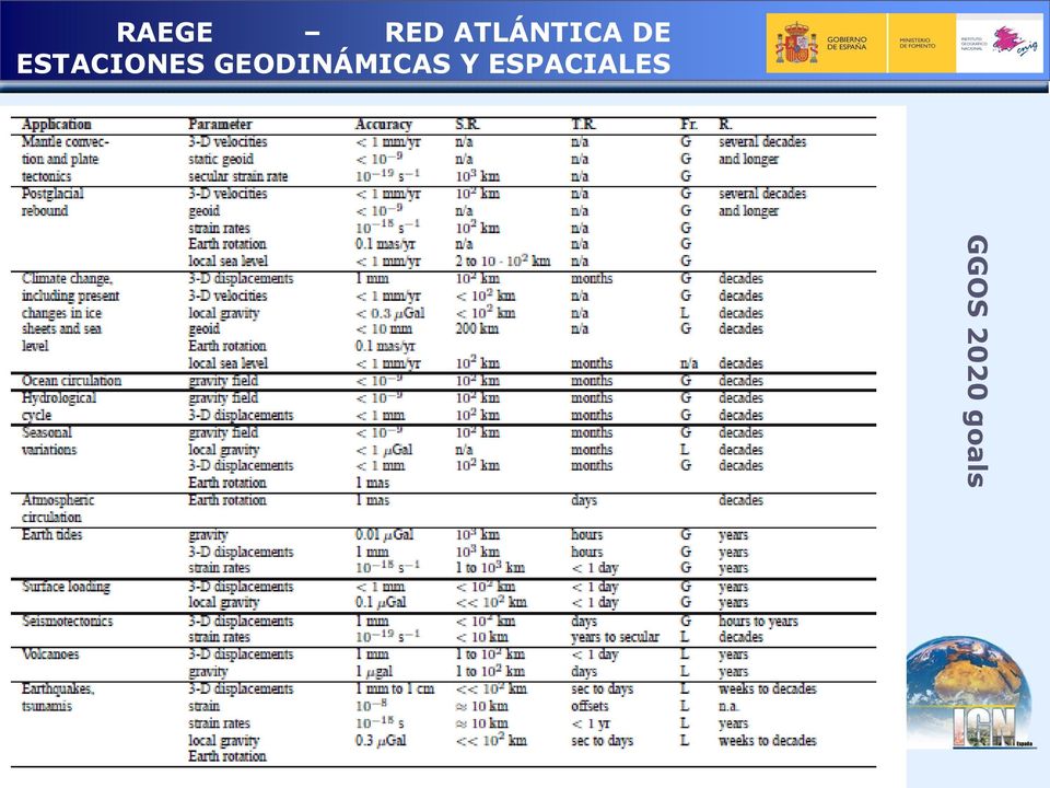
13 GGOS 2020 goals
14 VLBI2010 System Characteristics Current VLBI2010 antenna size m dish ~ 12 m dish slew speed ~ deg/min 360 deg/min sensitivity ,000 SEFD 2,500 SEFD frequency range S/X band ~2 15 (18) GHz recording rate 128, 256 Mbps 8 16 Gbps data transfer usually ship disks, some e-transfer e-transfer, e-vlbi, ship disks when required

15 The RAEGE project Establishment of an Spanish-Portuguese Network of Geodynamical and Space Geodesy Stations (RAEGE) by the installation and operation of four fundamental geodetic/astronomical stations provided with radio telescopes fulfilling the VLBI 2010 project specifications: Yebes (1), Canary Islands (1) and Açores Islands (2).
, Canary Islands (1) and")
16 Baselines: Yebes Canary Islands : 1800 km Yebes Sao Miguel : 2000 km Yebes Flores : 2400 km Canary Islands Flores : 2000 km Sao Miguel Flores : 540 km

17 Baselines: Yebes Flores : 2400 km Gran Canaria Flores : 2000 km Sao Miguel Flores : 540 km

18 Azores Islands, Portugal

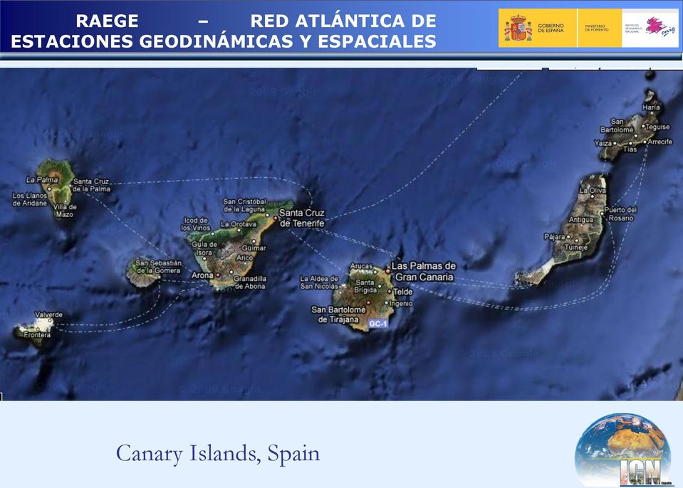
19 Canary Islands, Spain
20 Initial equipment to be installed at each RAEGE station Geodetic VLBI 2010 radiotelescope: Diameter 12m, freq 40GHz Many parts could be built in Spain. Superconducting gravimeter. Permanent GNSS station. Satellite Laser Ranging (Yebes).

21 RAEGE workshop Madrid, January 2009
22 RAEGE station in Yebes (Guadalajara, Spain)
23 GPS 40-m RT Gravimeter 14-m RT SLR New VLBI2010 RT
24 VLBI2010 radiotelescope Goals: 1mm position + 1mm/yr velocity accuracy Continuous observation of Earth parameters Small / fast moving Reduced sensitivity to RFI = wide band feeds TTW: 2 x 13.2 m RT, ring focus 12º/sec + 6º/sec moves
25 TTW radiotelescope optics: ring focus
: τg = ΔΦ/Δω 15000 X-Band 10000 5000 0 S-Band: Serious RFI 2 4 6 8 10 12 14 Frequency,")
26 PHASE(Arbitrary Units) RAEGE RED ATLÁNTICA DE Radio frequency observing bands Phase Delay: τφ = Φ/ω Group Delay (slope): τg = ΔΦ/Δω X-Band S-Band: Serious RFI Frequency, GHz
27 VLBI2010 radio feed ELEVEN feed: Developed at Chalmers University (Sweden) by Per-Simon Kildal. To operate in 2-14 GHz band. Coolable, but challenges to the mechanical construction.
28 Permanent IGS reference station YEBE : Core of IGN red de estaciones permanentes, ERGPS. A-class station in EUROGRAPHICS. Member of IGS and EUREF since 2001.
29 Permanent IGS station YEBE
30
31 Gravimeter building and equipment at Yebes: Seven pillars for instrument comparison Two gravimeters (A10 & FG5) Purchasing the first superconducting gravimeter (February 2010)
32 Future Satellite Laser Ranging (SLR) facility:
33 RAEGE stations in Azores
34
35 Meteorology: Acceptable. Wind below limits. Santa Maria Geological studies: Better in Saramago and Terras do Raposo. RFI: Radars to assist navigation at 2.3 GHz. Horizons: All < 8º Infraestructures: Fine. Better in Saramago.
36 Santa Maria: Saramago
37 Geological study of Santa Maria Aluvión Conglomerado Basaltos
38 km/h 01/01/ /02/ /03/ /04/ /05/ /06/ /07/ /08/ /09/ /10/ /11/ /12/2008 mm 01/01/ /02/ /03/ /04/ /05/ /06/ /07/ /08/ /09/ /10/ /11/ /12/2008 Cº RAEGE RED ATLÁNTICA DE Meteorology near Santa Maria Temperature Isla Ponta Delgada Temperatura media año Cº Rain Isla Ponta Delgada 120 Fecha Wind Isla Ponta Delgada Precipitacion Velocidad Máxima del Viento Fecha 40 Velocidad Media del Viento /01/ /01/ /03/ /03/ /04/ /05/ /06/ /07/ /08/2008 Fecha 27/09/ /10/ /11/ /12/2008
39 Flores Meteorology: Fine, but worse than in Santa María. Geological studies: Good conditions at sites. RFI: Radars to assist navigation at 2.3 GHz. Horizons: < 10º (except Pico do Touro). Infraestructures: Fine, better in Lajes.
40 Angulo º RAEGE RED ATLÁNTICA DE Flores: Lajes Máscara de Lajes Azimut
41 km/h 01/01/ /02/ /03/ /04/ /05/ /06/ /07/ /08/ /09/ /10/ /11/ /12/2008 mm 01/01/ /02/ /03/ /04/ /05/ /06/ /07/ /08/ /09/ /10/ /11/ /12/2008 Cº RAEGE RED ATLÁNTICA DE Meteorology at Flores Temperature Isla Flores Temperatura media año Cº Rain Isla Flores Fecha Wind Precipitacion Isla Flores Fecha Velocidad Máxima del Viento Velocidad Media del Viento /01/ /01/ /03/ /03/ /04/ /05/ /06/ /07/ /08/2008 Fecha 27/09/ /10/ /11/ /12/2008


42 Geological study of Flores Aluvión Conglomerado Basaltos
43 Azores work program in 2010 Meteorological stations to be installed in potential RAEGE station placements for continuous monitoring. Geological studies in all those locations. Radio frequency interference (RFI) measurements with stand-alone equipment. Range: 1 to 26.5 GHz Teodolite measurements in potential locations.
44 RAEGE station in Canary Islands (Spain) To be equipped with: - one radiotelescope - one GNSS receiver - one gravimeter Possible locations: - Mas Palomas -.
45 Real time data transfer and correlation (e-vlbi)
46 IGN capabilities and cooperation opportunities Long time experience in technical aspects of VLBI (radiotelescopes, front-ends and back-ends). Participation in the VLBI networks and organizations (IVS, EVN). Infrastructures and equipment for the main station (Yebes). IGN geodetic/geophysical centre at Canary Islands. Collaboration agreement between IGN and the Açores Regional Government. Ready to purchase the first three VLBI antennas in Grants available for training of scientists and engineers at Yebes:
47 Conclusion (1) The construction and operation of the RAEGE project, as conceived, represents a scientific and technical contribution of first magnitude to the global IVS VLBI2010 project, which will in turn represent a qualitative change in the techniques of geodetic VLBI and the scientific problems to be addressed in the next years (Earth Orientation Parameters, crustal dynamics, ) From a technical point of view, RAEGE incorporates the most modern instrumentation of the IVS VLBI2010 radio telescopes, as well as complementary equipment (superconducting gravimeter, GNSS, etc.). The construction and installation of this instrumentation is viable, and IGN has appropriate laboratories, workshops, and technical staff at Yebes Observatory, with experience in the techniques involved.
48 Conclusion (2) The spatial distribution of the stations to be built (Yebes, Açores, Canary Islands) is of great value for the geodynamical studies to be performed, both for its geographical and its tectonic distribution (European, African, and American plates). The international scientific communities of Astronomy, Geodesy, and Geophysics, in particular those in Spain and Portugal, will benefit with the RAEGE project. Moreover, the construction, installation, and put into operation of the instruments and equipment of the RAEGE project will make possible for the Spanish and Portuguese engineers, to perform technical developments in the fields of mechanics, electronics, computers, and telecommunications.
49 Grants available for training of scientists and engineers at Yebes: - Astronomy - Geodesy - Geophysics Deadline: November 17 th
50 Thank You!
Francisco Colomer 1. Jesús Gómez-González 1. Marlene C.S. Assis 2. José Antonio López-Fernández 1. IGN, Spain & 2 SRCTE, Portugal
 Francisco Colomer 1 Jesús Gómez-González 1 Marlene C.S. Assis 2 José Antonio López-Fernández 1 1 IGN, Spain & 2 SRCTE, Portugal http://www.raege.net/ GGOS Global Geodetic Observing System Spatial Data
The IGS: A Multi-GNSS Service
 The IGS: A Multi-GNSS Service Chris Rizos, Urs Hugentobler, Ruth Neilan IUGG IAG Structure International Union of Geodesy and Geophysics (IUGG) 65 Member Countries (Adhering Bodies), 8 Associations International
Evolving a new Geodetic Positioning Framework: An Australian Perspective
 Evolving a new Geodetic Positioning Framework: An Australian Perspective G. Johnston, J. Dawson Outline Introduction Precise Positioning National Geospatial Reference Systems Asia Pacific Reference Frame
Günter Seeber. Satellite Geodesy 2nd completely revised and extended edition
 Günter Seeber Satellite Geodesy 2nd completely revised and extended edition Walter de Gruyter Berlin New York 2003 Contents Preface Abbreviations vii xvii 1 Introduction 1 1.1 Subject of Satellite Geodesy...
GGOS and the Importance of the Combination of Space Techniques. Hansjörg Kutterer Federal Agency for Cartography and Geodesy, Germany
 GGOS and the Importance of the Combination of Space Techniques Hansjörg Kutterer Federal Agency for Cartography and Geodesy, Germany Content Combination of space-geodetic techniques Combination examples
GNSS permanent stations as the part of integrated geodetic system in Estonia
 GNSS permanent stations as the part of integrated geodetic system in Estonia Karin Kollo (MSc) Department of Geodesy Estonian Land Board United Nations/Croatia Workshop on the applications of Global Navigation
GGOS Bureau for Networks and Commuications Michael Pearlman Harvard-Smithsonian Center for Astrophysics Cambridge MA USA mpearlman@cfa.harvard.
 GGOS Bureau for Networks and Commuications Michael Pearlman Harvard-Smithsonian Center for Astrophysics Cambridge MA USA mpearlman@cfa.harvard.edu GGOS Bureau for Networks and Communications Donatello
The goals, achievements, and tools of modern geodesy
 Chapter 2 The goals, achievements, and tools of modern geodesy H.-P. Plag, Z. Altamimi, S. Bettadpur, G. Beutler, G. Beyerle, A. Cazenave, D. Crossley, A. Donnellan, R. Forsberg, R. Gross, J. Hinderer,
Gravity Field Services coordinating global gravity field activities
 Gravity Field Services coordinating global gravity field activities Rene Forsberg National Space Institute (DTU-Space), Denmark Steve Kenyon National Geospatial-Intelligence Agency, USA International Gravity
Scheduling of VLBI observations to satellites with the Vienna VLBI Software (VieVS)
") 22 nd EVGA Working Meeting, May 17-21, 2015, Sao Miguel, Pont Delgada, Azores, Portugal Scheduling of VLBI observations to satellites with the Vienna VLBI Software (VieVS) Andreas Hellerschmied 1, J. Böhm
22 nd EVGA Working Meeting, May 17-21, 2015, Sao Miguel, Pont Delgada, Azores, Portugal Scheduling of VLBI observations to satellites with the Vienna VLBI Software (VieVS) Andreas Hellerschmied 1, J. Böhm
GEOPHYSICAL EFFECTS ON SITE DISPLACEMENTS FOR PERMANENT GPS TRACKING STATIONS IN TAIWAN
 GEOPHYSICAL EFFECTS ON SITE DISPLACEMENTS FOR PERMANENT GPS TRACKING STATIONS IN TAIWAN C. C. Chang Department of Surveying and Mapping Engineering Chung Cheng Institute of Technology Tahsi, Taoyuan 335,
Alfons-Goppel-Str. 11, D-80539 München
 Combination method of different space geodesy techniques for EOP and terrestrial reference frame determination Vojtěch Štefka Alfons-Goppel-Str. 11, D-80539 München Contents: Introduction: ICRS, ITRS and
Trimble CenterPoint RTX Post-Processing Services FAQs
 Trimble CenterPoint RTX Post-Processing Services FAQs What is Trimble RTX technology? 30 September 2013 Trimble RTX TM (Real Time extended) is a high-accuracy, global GNSS correction technology that combines
International Gravity Field Service (IGFS)
") IAG Services: International Gravity Field Service (IGFS) 1 International Gravity Field Service (IGFS) http://www.gravityfield.org Chairman: Renè Forsberg (Denmark, 2011-2013) - Riccardo Barzaghi (Italy,
IAG Services: International Gravity Field Service (IGFS) 1 International Gravity Field Service (IGFS) http://www.gravityfield.org Chairman: Renè Forsberg (Denmark, 2011-2013) - Riccardo Barzaghi (Italy,
Satellite Posi+oning. Lecture 5: Satellite Orbits. Jan Johansson jan.johansson@chalmers.se Chalmers University of Technology, 2013
 Lecture 5: Satellite Orbits Jan Johansson jan.johansson@chalmers.se Chalmers University of Technology, 2013 Geometry Satellite Plasma Posi+oning physics Antenna theory Geophysics Time and Frequency GNSS
GPS Precise Point Positioning as a Method to Evaluate Global TanDEM-X Digital Elevation Model
 GPS Precise Point Positioning as a Method to Evaluate Global TanDEM-X Digital Elevation Model 7 th FIG Regional Conference TS 1C Advances in GNSS Positioning and Applications I Volker Schwieger 1, Jürgen
NASA Earth System Science: Structure and data centers
 SUPPLEMENT MATERIALS NASA Earth System Science: Structure and data centers NASA http://nasa.gov/ NASA Mission Directorates Aeronautics Research Exploration Systems Science http://nasascience.nasa.gov/
European Geodetic Status European Geodetic Reference Systems
 European Geodetic Status European Geodetic Reference Systems Reporter: Hansjörg Kutterer, Federal Agency of Cartography and Geodäsie (BKG), Germany Contributors to this report: Johannes Ihde, Federal Agency
Why do we need to improve co-locations of space geodetic techniques?
 Why do we need to improve co-locations of space geodetic techniques? Zuheir Altamimi & Xavier Collilieux IGN France 1 Outline ITRF Heritage Current status of technique networks & co-locations Results from
How To Monitor Sea Level With Satellite Radar
 Satellite Altimetry Wolfgang Bosch Deutsches Geodätisches Forschungsinstitut (DGFI), München email: bosch@dgfi.badw.de Objectives You shall recognize satellite altimetry as an operational remote sensing
International Global Navigation Satellite Systems Service
 International Global Navigation Satellite Systems Service IGS Multi-GNSS Experiment IGS M-GEX Call for Participation www.igs.org Response to this Call for Participation in IGS M-GEX via Web Form Submission
Revolution in Geodesy, Navigation, and Surveying
 Univ.-Prof. Dr.-Ing. Prof. h.c. Günter Seeber anlässlich seines 65. Geburtstages und der Verabschiedung in den Ruhestand. Wissenschaftliche Arbeiten der Fachrichtung Geodäsie und Geoinformatik der Universität
Simulation, prediction and analysis of Earth rotation parameters
 Simulation, prediction and analysis of Earth rotation parameters with a dynamic Earth system model Florian Seitz Earth Oriented Space Science and Technology (ESPACE) 20.9.2011 Earth rotation parameters
Overview of outreach activities at OAN-Yebes
 Overview of outreach activities at OAN-Yebes Francisco Paco Colomer f.colomer@oan.es Observatorio Astronómico Nacional / Yebes Instituto Geográfico Nacional Spain Yebes Observatory (Guadalajara, Spain)
Gravity Field and Dynamics of the Earth
 Milan Bursa Karel Pec Gravity Field and Dynamics of the Earth With 89 Figures Springer-Verlag Berlin Heidelberg New York London Paris Tokyo HongKong Barcelona Budapest Preface v Introduction 1 1 Fundamentals
German Antarctic Receiving Station GARS O Higgins: Remote sensing as core for a broader range of activities
 DLR.de Chart 1 > Kathrin Hoeppner > EU-Chile-Workshop > November 28-29, 2013 > Punta Arenas, Chile German Antarctic Receiving Station GARS O Higgins: Remote sensing as core for a broader range of activities
Economic and Social Council 8 July 2016
 ADVANCE UNEDITED VERSION UNITED NATIONS E/C.20/2016/4/Add.1 Economic and Social Council 8 July 2016 Committee of Experts on Global Geospatial Information Management Sixth session New York, 3-5 August 2016
Congreso Internacional Geomática Andina 2012 4 y 5 de junio, Bogotá, D. C., Colombia
 Claudio Brunini SIRGAS President UNLP - CONICET Argentina Laura Sánchez SIRGAS Vice-President DGFI - Germany William Martínez SIRGAS WGII President IGAC - Colombia María Viriginia Mackern SIRGAS - WGI
Geological hazards and monitoring activities at the Azores archipelago
 Geological hazards and monitoring activities at the Azores archipelago Teresa Ferreira (1,2), João Gaspar (1,2), Gabriela Queiroz (1,2) (1) CVARG (Centre for Volcanology and Geological Risks Assessment)
Chapter 34 Latest GNSS Results of the CMONOC Network and Its Application in Earthquake Monitoring
 Chapter 34 Latest GNSS Results of the CMONOC Network and Its Application in Earthquake Monitoring Junping Chen, Yize Zhang, Yibing Xie, Weijie Tan, Sainan Yang and Bin Wu Abstract Crustal Movement Observation
Examination Space Missions and Applications I (AE2103) Faculty of Aerospace Engineering Delft University of Technology SAMPLE EXAM
 Faculty of Aerospace Engineering Delft University of Technology SAMPLE EXAM") Examination Space Missions and Applications I AE2103 Faculty of Aerospace Engineering Delft University of Technology SAMPLE EXAM Please read these instructions first: This are a series of multiple-choice
Examination Space Missions and Applications I AE2103 Faculty of Aerospace Engineering Delft University of Technology SAMPLE EXAM Please read these instructions first: This are a series of multiple-choice
The Use and Integrity Monitoring of IGS Products at Geoscience Australia (GA)
") Australian Government Geoscience Australia The Use and Integrity Monitoring of IGS Products at Geoscience Australia (GA) Ramesh Govind, John Dawson, John Manning IGS-2004 Workshop and Symposium Berne,
Australian Government Geoscience Australia The Use and Integrity Monitoring of IGS Products at Geoscience Australia (GA) Ramesh Govind, John Dawson, John Manning IGS-2004 Workshop and Symposium Berne,
Online Precise Point Positioning Using the. Natural Resources Canada Canadian Spatial Reference System (CSRS-PPP)
") Online Precise Point Positioning Using the Natural Resources Canada Canadian Spatial Reference System (CSRS-PPP) Thomas Nylen and Seth White UNAVCO October 2007 I. Precise Point Positioning Precise Point
Online Precise Point Positioning Using the Natural Resources Canada Canadian Spatial Reference System (CSRS-PPP) Thomas Nylen and Seth White UNAVCO October 2007 I. Precise Point Positioning Precise Point
COLOCATIONS AND MONUMENTATION IN THE DORIS NETWORK
 COLOCATIONS AND MONUMENTATION IN THE DORIS NETWORK Hervé FAGARD (Institut Géographique National - France) 1 H. Fagard (IGN-F) Antenna types in the DORIS permanent network Alcatel Starec 10 stations Deployed
Satellite Altimetry Missions
 Satellite Altimetry Missions SINGAPORE SPACE SYMPOSIUM 30 TH SEPTEMBER 2015 AUTHORS: LUCA SIMONINI/ ERICK LANSARD/ JOSE M GONZALEZ www.thalesgroup.com Table of Content General Principles and Applications
Use the following information to deduce that the gravitational field strength at the surface of the Earth is approximately 10 N kg 1.
 IB PHYSICS: Gravitational Forces Review 1. This question is about gravitation and ocean tides. (b) State Newton s law of universal gravitation. Use the following information to deduce that the gravitational
Rotational Errors in IGS Orbit & ERP Products
 Rotational Errors in IGS Orbit & ERP Products Systematic rotations are a leading IGS error they affect all core products except probably clocks Sources include defects in: IERS model for 12h + 24h tidal
ICSU World Data System Global Data for Global Sustainability
 ICSU World Data System Global Data for Global Sustainability Jean Bernard Minster Chair, WDS Scientific Committee Presentation to PuP, 03/27/2012 WDS creation ICSU 29 th General Assembly decision in Maputo
IDS Data Flow Coordination (2009)
") IDS Data Flow Coordination (2009) Introduction Two data centers currently support the archiving and access activities for the IDS: Crustal Dynamics Data Information System (CDDIS), NASA GSFC, Greenbelt,
IDS Data Flow Coordination (2009) Introduction Two data centers currently support the archiving and access activities for the IDS: Crustal Dynamics Data Information System (CDDIS), NASA GSFC, Greenbelt,
Summary of the determination and analysis of the ETRS89 coordinates for the GNSS Reference Station Network
 Summary of the determination and analysis of the ETRS89 coordinates for the GNSS Reference Station Network Document References and approaches: -Capilla, Saa, Die (2006): Diseño, aplicaciones integradas
AMIGO Memorandum of Understanding (August 15, 1998)
") AMIGO Memorandum of Understanding (August 15, 1998) Memorandum of Understanding among L École Mohammadia d'ingénieurs, Université Mohamed V, Morocco (EMI); A Faculdade de Ciências da Universidade de Lisboa,
AMIGO Memorandum of Understanding (August 15, 1998) Memorandum of Understanding among L École Mohammadia d'ingénieurs, Université Mohamed V, Morocco (EMI); A Faculdade de Ciências da Universidade de Lisboa,
California Standards Grades 9 12 Boardworks 2009 Science Contents Standards Mapping
 California Standards Grades 912 Boardworks 2009 Science Contents Standards Mapping Earth Sciences Earth s Place in the Universe 1. Astronomy and planetary exploration reveal the solar system s structure,
Appendix 3: Contact addresses of the IERS components
 Appendices Appendix 3: Contact addresses of the IERS components Analysis Coordinator Central Bureau Thomas Herring Massachusetts Institute of Technology 77 Massachusetts Avenue, Building 54-618 Cambridge,
Case Study Australia. Dr John Dawson A/g Branch Head Geodesy and Seismic Monitoring Geoscience Australia. Chair UN-GGIM-AP WG1 Chair APREF.
 Case Study Australia Dr John Dawson A/g Branch Head Geodesy and Seismic Monitoring Geoscience Australia Chair UN-GGIM-AP WG1 Chair APREF Page 1 Overview 1. Australian height system Australian Height Datum
Introduction into Real-Time Network Adjustment with Geo++ GNSMART
 Introduction into Real-Time Network Adjustment with Geo++ GNSMART Andreas Bagge Gerhard Wübbena, Martin Schmitz Geo++ GmbH D-30827 Garbsen, Germany www.geopp.de GeoInformation Workshop 2004, Istanbul Kultur
GPS Precise Point Positioning with a Difference*
 GPS Precise Point Positioning with a Difference* Pierre Héroux and Jan Kouba Geodetic Survey Division, Geomatics Canada Natural Resources Canada 615 Booth Street Ottawa, Ontario K1A E9 heroux@geod.nrcan.gc.ca
Pacific Sea Level Monitoring Project
 Record 2015/04 GeoCat 82325 Pacific Sea Level Monitoring Project CGPS Coordinate Time Series Analysis Report Jia, M., Dawson, J., Twilley, B. and Hu, G. APPLYING GEOSCIENCE TO AUSTRALIA S MOST IMPORTANT
Science Standard 4 Earth in Space Grade Level Expectations
 Science Standard 4 Earth in Space Grade Level Expectations Science Standard 4 Earth in Space Our Solar System is a collection of gravitationally interacting bodies that include Earth and the Moon. Universal
Scheduling of VLBI observations to satellites with the Vienna VLBI Software (VieVS)
") Scheduling of VLBI observations to satellites with the Vienna VLBI Software (VieVS) A. Hellerschmied, J. Böhm, R. Haas, J. Kodet, A. Neidhardt, L. Plank Abstract The observation of satellites with VLBI
Scheduling of VLBI observations to satellites with the Vienna VLBI Software (VieVS) A. Hellerschmied, J. Böhm, R. Haas, J. Kodet, A. Neidhardt, L. Plank Abstract The observation of satellites with VLBI
A New Map of UK Vertical Land Movements based on Continuous GPS and Absolute Gravity
 A New Map of UK Vertical Land Movements based on Continuous GPS and Absolute Gravity Dionne Hansen(Nottingham), Norman Teferle(Nottingham), Richard Bingley(Nottingham) And Simon Williams(POL) EGU2009,
International time scales Atomic standards
 International time scales Atomic standards E.F. Arias International Committee for GNSS, 2 nd Meeting Meeting of GNSS experts Bangalore, 5 September 2007 OUTLINE International coordination for metrology;
Non-parametric estimation of seasonal variations in GNSS-derived time series
 Military University of Technology, Poland (marta.gruszczynska@wat.edu.pl) Seasonal variations in the frame sites can bias the frame realization. I would like to invite you to click on each of the four
Data transport in radio astronomy. Arpad Szomoru, JIVE
 Data transport in radio astronomy Arpad Szomoru, JIVE Some acronyms EVN: European VLBI Network Consortium of radio telescopes Involving 14 different organizations around the world: Europe, China, Puerto
Time and frequency distribution using satellites
 INSTITUTE OF PHYSICS PUBLISHING Rep. Prog. Phys. 65 (2002) 1119 1164 REPORTS ON PROGRESS IN PHYSICS PII: S0034-4885(02)98967-0 Time and frequency distribution using satellites Judah Levine Time and Frequency
Laser Ranging to Nano-Satellites
 13-0222 Laser Ranging to Nano-Satellites G. Kirchner (1), Ludwig Grunwaldt (2), Reinhard Neubert (2), Franz Koidl (1), Merlin Barschke (3), Zizung Yoon (3), Hauke Fiedler (4), Christine Hollenstein (5)
Assessing Long Term Trends in the Atmospheric Water Vapor Content by Combining Data From VLBI, GPS, Radiosondes and Microwave Radiometry
 Assessing Long Term Trends in the Atmospheric Water Vapor Content by Combining Data From VLBI, GPS, Radiosondes and Microwave Radiometry 1 Introduction Onsala Space Observatory, Chalmers University of
AMENDMENT 1 3 January 2000. DEPARTMENT OF DEFENSE WORLD GEODETIC SYSTEM 1984 Its Definition and Relationships with Local Geodetic Systems
 AMENDMENT 1 3 January 2000 DEPARTMENT OF DEFENSE WORLD GEODETIC SYSTEM 1984 Its Definition and Relationships with Local Geodetic Systems These pages document the changes made to this document as of the
Towards the Realization of Geo-Referencing Infrastructure for Dynamic Japan (GRID-Japan) Hiromichi TSUJI and Kazuo KOMAKI
 Hiromichi TSUJI and Kazuo KOMAKI") 1 Towards the Realization of Geo-Referencing Infrastructure for Dynamic Japan (GRID-Japan) Hiromichi TSUJI and Kazuo KOMAKI Abstract The recent change of the geodetic reference system of Japan from the
1 Towards the Realization of Geo-Referencing Infrastructure for Dynamic Japan (GRID-Japan) Hiromichi TSUJI and Kazuo KOMAKI Abstract The recent change of the geodetic reference system of Japan from the
Example application of the IAU 2000 resolutions concerning Earth orientation and rotation
 Example application of the IAU 2000 resolutions concerning Earth orientation and rotation Patrick Wallace 1 (Original version 20 July 2004, revised 29 July 2004; this reformatted and corrected version
AUTOMATED OPERATIONAL MULTI-TRACKING HIGH PRECISION ORBIT DETERMINATION FOR LEO MISSIONS
 AUTOMATED OPERATIONAL MULTI-TRACKING HIGH PRECISION ORBIT DETERMINATION FOR LEO MISSIONS J. Fernández Sánchez, F. M. Martínez Fadrique, A. Águeda Maté, D. Escobar Antón GMV S.A., Isaac Newton 11, 876 Tres
The Next Generation Science Standards (NGSS) Correlation to. EarthComm, Second Edition. Project-Based Space and Earth System Science
 Correlation to. EarthComm, Second Edition. Project-Based Space and Earth System Science") The Next Generation Science Standards (NGSS) Achieve, Inc. on behalf of the twenty-six states and partners that collaborated on the NGSS Copyright 2013 Achieve, Inc. All rights reserved. Correlation to,
The Next Generation Science Standards (NGSS) Achieve, Inc. on behalf of the twenty-six states and partners that collaborated on the NGSS Copyright 2013 Achieve, Inc. All rights reserved. Correlation to,
THE CURRENT EVOLUTIONS OF THE DORIS SYSTEM
 THE CURRENT EVOLUTIONS OF THE DORIS SYSTEM TAVERNIER, G.; GRANIER, J.P.; JAYLES, C.; SENGENES, P. (CNES) ROZO, F. (COFRAMI) presented by P. VINCENT (CNES) Table of Contents System and Missions Satellites:
1 General definitions and numerical standards
 No. 36 This chapter provides definitions for some topics that are relevant to several chapters of the document, such as the tide systems in Section 1.1 and the units of relativistic time scales and associated
Interaction of Energy and Matter Gravity Measurement: Using Doppler Shifts to Measure Mass Concentration TEACHER GUIDE
 Interaction of Energy and Matter Gravity Measurement: Using Doppler Shifts to Measure Mass Concentration TEACHER GUIDE EMR and the Dawn Mission Electromagnetic radiation (EMR) will play a major role in
GNSS re-processing results at GOP and the latest updates of ITRS/ETRS. Jan Douša (jan.dousa@pecny.cz)
") GNSS re-processing results at GOP and the latest updates of ITRS/ETRS Jan Douša (jan.dousa@pecny.cz) Geodetic observatory Pecný, Research Institute of Geodesy, Topography and Cartography January 24, 2012
GNSS re-processing results at GOP and the latest updates of ITRS/ETRS Jan Douša (jan.dousa@pecny.cz) Geodetic observatory Pecný, Research Institute of Geodesy, Topography and Cartography January 24, 2012
GNSS and Heighting, Practical Considerations. A Parker National Geo-spatial Information Department of Rural Development and Land Reform
 GNSS and Heighting, Practical Considerations A Parker National Geo-spatial Information Department of Rural Development and Land Reform GNSS Global Navigation Satellite Systems (GNSS) Global Positioning
European Position Determination System. Guideline for EUPOS Reference Frame Fixing
 European Position Determination System Guideline for EUPOS Reference Frame Fixing Version 1.0 21 September 2007 Copyright: Publisher: 2007 by the International EUPOS Steering Committee Office of the International
THE ROYAL JORDANIAN GEOGRAPHIC CENTER
 THE ROYAL JORDANIAN GEOGRAPHIC CENTER Outlines: 1- Establishment & Duties 2- Organizational Structure 3- Most Important Achievements 4- Ambitions & Future Vision 2 Establishment & Duties Map Production
PRECISE EPHEMERIDES FOR GPS TIME TRANSFER
 PRECISE EPHEMERIDES FOR GPS TIME TRANSFER W. Lewandowski Bureau International des Poids et Mesures Pavillon de Breteuil 92312 Sevres Cedex, France and M. A. Weiss United States Department of Commerce National
Prof. Ludovico Biagi. Satellite Navigation and Monitoring
 Prof. Ludovico Biagi Satellite Navigation and Monitoring Navigation: trajectories control positions estimations in real time, at high frequency popular applications: low accuracy (10 m) required specific
The Chief Directorate: National
 Surveying The South African Coordinate Reference System (Part 1) by Aslam Parker, Chief Directorate: National Geo-spatial Information This article will define the various elements of the South African
Recent Advances in Pixel Localization Accuracy
 Recent Advances in Pixel Localization Accuracy U. Balss, X. Cong, M. Eineder, H. Breit, T. Fritz, B. Schättler Remote Sensing Technology Institute (IMF) German Aerospace Center (DLR) Outline Operational
European Gravity Service for Improved Emergency Management
 European Gravity Service for Improved Emergency Management a new Horizon2020 project to serve the international community and improve the accessibility to gravity field products A. Jäggi 1, M. Weigelt
102 26-m Antenna Subnet Telecommunications Interfaces
 DSMS Telecommunications Link Design Handbook 26-m Antenna Subnet Telecommunications Interfaces Effective November 30, 2000 Document Owner: Approved by: Released by: [Signature on file in TMOD Library]
Satellite'&'NASA'Data'Intro'
 Satellite'&'NASA'Data'Intro' Research'vs.'Opera8ons' NASA':'Research'satellites' ' ' NOAA/DoD:'Opera8onal'Satellites' NOAA'Polar'Program:'NOAA>16,17,18,19,NPP' Geosta8onary:'GOES>east,'GOES>West' DMSP'series:'SSM/I,'SSMIS'
Real-Time GNSS in Routine EPN Operations Concept
 Real-Time GNSS in Routine EPN Operations Concept EPN Real-time Working Group D. Dettmering, G. Weber, C. Bruyninx, H. v.d.marel W. Gurtner, J. Torres, A. Caporali Status: December 3, 2006 1 CONTENT 1 Introduction
RBMC: The main geodetic infrastructure contributing for land reform and weather researches in Brazil
 RBMC: The main geodetic infrastructure contributing for land reform and weather researches in Brazil Sonia Costa - IBGE Hisao Takahashi and Luiz Sapucci - INPE Workshop on the Applications of Global Navigation
Guideline for Control Surveys by Differential Levelling
 Guideline for Control Surveys by Differential Levelling Special Publication 1 Intergovernmental Committee on Surveying and Mapping (ICSM) Permanent Committee on Geodesy (PCG) 24 September 2014 Intergovernmental
1. Introduction. FER-Zagreb, Satellite communication systems 2011/12
 1. Introduction Topics History Characteristics of satellite communications Frequencies Application 1 History Arthur C. Clark suggested in 1945. Earth coverage with 3 geostationary satellites. On 4th of
Summary Report on National and Regional Projects set-up in Russian Federation to integrate different Ground-based Observing Systems
 WORLD METEOROLOGICAL ORGANIZATION COMMISSION FOR INSTRUMENT AND METHODS OF OBSERVATION OPAG-UPPER AIR EXPERT TEAM ON REMOTE SENSING UPPER-AIR TECHNOLOGY AND TECHNIQUES First Session Geneva, Switzerland,
European Gravity Service for Improved Emergency Management
 European Gravity Service for Improved Emergency Management a new Horizon2020 project to serve the international community and improve the accessibility to gravity field products A. Jäggi 1, M. Weigelt
Earth Sciences -- Grades 9, 10, 11, and 12. California State Science Content Standards. Mobile Climate Science Labs
 Earth Sciences -- Grades 9, 10, 11, and 12 California State Science Content Standards Covered in: Hands-on science labs, demonstrations, & activities. Investigation and Experimentation. Lesson Plans. Presented
Solar System. 1. The diagram below represents a simple geocentric model. Which object is represented by the letter X?
 Solar System 1. The diagram below represents a simple geocentric model. Which object is represented by the letter X? A) Earth B) Sun C) Moon D) Polaris 2. Which object orbits Earth in both the Earth-centered
INTEGRATED ANALYSIS OF THE ENVIRONMENTAL MONITORING MEASUREMENTS IN THE GEODYNAMIC TEST NETWORK SÓSKÚT
 PERIODICA POLYTECHNICA SER. CIV. ENG. VOL. 46, NO. 2, PP. 159 168 (2002) INTEGRATED ANALYSIS OF THE ENVIRONMENTAL MONITORING MEASUREMENTS IN THE GEODYNAMIC TEST NETWORK SÓSKÚT József ÁDÁM, László BÁNYAI,
North American Horizontal Datums. Jan Van Sickle
 North American Horizontal Datums Jan Van Sickle http://www.holoscenes.com/cgi-bin/moin.cgi/easternobliquearc The New England Datum 1879 was the first geodetic datum of this type in the United States. The
Monitoring and Early Management of Emergences: New Instruments
 Monitoring and Early Management of Emergences: New Instruments Daniele Caviglia, DITEN - University of Genoa Domenico Sguerso, DICCA - University of Genoa Bianca Federici, DICCA - University of Genoa Andrea
The Moon. Nicola Loaring, SAAO
 The Moon Nicola Loaring, SAAO Vital Statistics Mean distance from Earth Orbital Period Rotational Period Diameter 384,400 km 27.322 days 27.322 days 3476 km (0.272 x Earth) Mass 7.3477 10 22 kg (0.0123
EarthScope Science Plan
 EarthScope Science Plan 1 Process Original EarthScope Science workshop: October 10-12, 2001, Snowbird UT. Implementation of EarthScope MREFC: 2004-2008 Workshop for an EarthScope Science Plan (WESP): October
View. A New. Into Earth
 View A New Into Earth EarthScope is a bold undertaking to apply modern observational, analytical and telecommunications technologies to investigate the structure and evolution of the North American continent
SARAL ACCESS TO OFF-LINE DATA
 SARAL AltiKa introduction Plot of the SARAL/AltiKa ground track over Africa (Credits: Google). S ARAL/AltiKa is a new mission in cooperation between CNES and ISRO (Indian Space Research Organization),
The Earth System. The geosphere is the solid Earth that includes the continental and oceanic crust as well as the various layers of Earth s interior.
 The Earth System The atmosphere is the gaseous envelope that surrounds Earth. It consists of a mixture of gases composed primarily of nitrogen, oxygen, carbon dioxide, and water vapor. The atmosphere and
LLAMA Long Latin American Millimeter Array
 LLAMA Long Latin American Millimeter Array The possibility of installing radio telescope(s) for millimeter and sub-millimeter wavelengths, in the Argentinean side of the Atacama desert at distances of
Istanbul Technical University-Center for Satellite Communications and Remote Sensing (ITU-CSCRS)
") Istanbul Technical University-Center for Satellite Communications and Remote Sensing (ITU-CSCRS) Istanbul Technical University, Center for Satellite Communications and Remote Sensing (ITU-CSCRS) was originally
Istanbul Technical University-Center for Satellite Communications and Remote Sensing (ITU-CSCRS) Istanbul Technical University, Center for Satellite Communications and Remote Sensing (ITU-CSCRS) was originally
Perspective of Permanent Reference Network KOPOS in Kosova
 143 Perspective of Permanent Reference Network KOPOS in Kosova Meha, M. and Çaka, M. Kosovo Cadastral Agency, Kosovo Archive Building II nd floor, P.O. 10000, Prishtina, Republic of Kosovo, E-mail: mmeha@yahoo.com,
Scope and Sequence Interactive Science grades 6-8
 Science and Technology Chapter 1. What Is Science? 1. Science and the Natural World 2.Thinking Like a Scientist 3. Scientific Inquiry Scope and Sequence Interactive Science grades 6-8 Chapter 2. Science,
SOFA software support for IAU 2000
 SOFA software support for IAU 2000 Patrick Wallace Rutherford Appleton Laboratory, UK ptw@star.rl.ac.uk Presentation outline Introduction to SOFA IAU 2000 and SOFA Software design choices Examples SOFA
16 th IOCCG Committee annual meeting. Plymouth, UK 15 17 February 2011. mission: Present status and near future
 16 th IOCCG Committee annual meeting Plymouth, UK 15 17 February 2011 The Meteor 3M Mt satellite mission: Present status and near future plans MISSION AIMS Satellites of the series METEOR M M are purposed
2. Orbits. FER-Zagreb, Satellite communication systems 2011/12
 2. Orbits Topics Orbit types Kepler and Newton laws Coverage area Influence of Earth 1 Orbit types According to inclination angle Equatorial Polar Inclinational orbit According to shape Circular orbit
Marine route optimization. Jens Olaf Pepke Pedersen Polar DTU / DTU Space www.polar.dtu.dk www.space.dtu.dk
 Marine route optimization Jens Olaf Pepke Pedersen Polar DTU / DTU Space www.polar.dtu.dk www.space.dtu.dk Early attempt at route optimization Jens Munk (1579-1628) Tries to find a way to India through
Georgia Performance Standards Framework for Science Grade 6. Unit Organizer: Water in Earth s Processes. (Approximate Time: 5-6 Weeks)
") The following instructional plan is part of a GaDOE collection of Unit Frameworks, Performance Tasks, examples of Student Work, and Teacher Commentary. Many more GaDOE approved instructional plans are
The following instructional plan is part of a GaDOE collection of Unit Frameworks, Performance Tasks, examples of Student Work, and Teacher Commentary. Many more GaDOE approved instructional plans are