Height Datum & Height Determination using GNSS in Singapore
|
|
|
- Teresa Washington
- 9 years ago
- Views:
Transcription
1 Height Datum & Height Determination using GNSS in Singapore Dr Victor Khoo Land Survey Division 1 Presenter: 2010 Singapore Land Authority SLA 2015

2 Singapore

3 Singapore Land Authority Presenter:

4 Singapore Land Authority (SLA) SLA is a statutory board formed by an Act of Parliament in Jun Merger of 4 former land departments Land Office Singapore Land Registry (SLR) Singapore Land Authority Land Survey Department (SVY) Land Systems Support Unit
 Singapore Land Authority Land Survey Department")
5 SLA s Vision Limited Land Unlimited Space highlights the nation's constraints and SLA's commitment in addressing them SLA s role ensure the best use of State land and buildings, provide an effective and reliable land management system, including the issuance and guarantee of land titles and geospatial demarcation of land, and enable the full use of land information for better land management and creation of new business opportunities.

6 New Maps are 3D Google

7 What drives 3D mapping? Expectation and Demand Explore the world without leaving your living room with our unique 3D maps. All you need is a web browser 3D applications are becoming increasingly important Convergence of hardware, software and data model to support 3D

8 UNGGIM - Trends in Technology and the future direction of data creation, maintenance and management (2013) The trend of moving from 2D mapping through to 3D and on to 4D visualisations is technology-driven and will accelerate. Users will expect much more complex and realistic models, to enable effective planning and management and to optimise resources.

9 FIG - Beyond Cadastre 2014 Multipurpose Cadastre Describe 6 characteristics of future cadastres 1. Survey-Accurate Cadastres 2. Object-Oriented Cadastres 3. 3D/4D Cadastres 4. Real-Time Cadastres 5. Global Cadastres 6. Organic Cadastres Rohan BENNETT, Abbas RAJABIFARD, Mohsen KALANTARI, Jude WALLACE and Ian WILLIAMSON, Australia

10 ICSM (Australia & New Zealand) Cadastre 2034 Vision for Cadastre A cadastral system that enables people to readily and confidently identify the location and extent of all rights, restrictions and responsibilities related to land and real property. A digital representation of the cadastre that is 3- dimensional, dynamic and survey accurate

11 Climate Change and Height Datum

12 Presenter: 12 Derick Tan SLA 2015
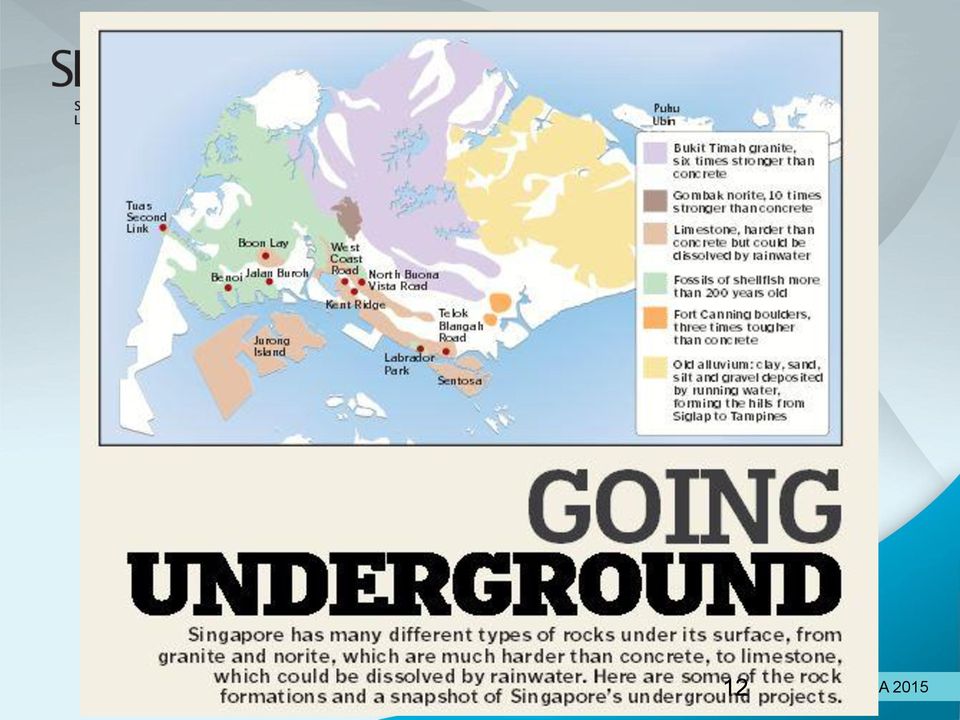
13 Utilities such as water and gas pipes, from near the surface to about 20m deep Train stations and tunnels, offices, malls, carparks, laboratories and other facilities intended for people at 15m to 40m deep Common Services Tunnel This tunnel system houses power cables, Pipes and other infrastructure for the Marina Bay area Other uses that involve fewer people, such as cable tunnels, oil storage caverns and reservoirs, from 30m to 130m deep. SAF Underground Ammunition Facility It is located in Mandai at an unknown depth, under disused quarry, and is for ammunition storage Jurong Rock Caverm It is being built 130m below Banyan Basin on Jurong Island to store crude oil and other petroleum products

14 Underground Science City

15 Building Spaces in Singapore? 15

16 Building Industrial Space over Expressway in Singapore

17 Smart Nation needs 3D Geospatial Information, as key information to support its development and operation

18 Concept of Ownership 2D Cadastre - one owned everything from the centre of the earth to the heaven

19 Extent of Underground Ownership Early this year - Amendments to the State Lands Act and the Land Acquisition Act are passed to facilitate the Government s long-term planning for the use and development of underground space in the future The amendments to the State Lands Act clarified that surface landowners own the underground space up to 30 metres under the Singapore Height Datum, unless otherwise specified in the State title. The amendments will not affect how landowners currently use and develop underground space, and landowners will continue to own all the space they need.

20 Survey Department Datum (now known as Singapore Height Datum) Based on the MSL determined at tide gauge located at the Victoria Dock ( ) Keppel East Wharf
 Keppel East")
21 Tide Gauge at Victoria Dock Tidal observation between 1935 to 1937 to determine the mean sea level at Victoria Dock Standard BM No. 1 was established in 1958 Tide Gauge was demolished in 1982
22 What is HWM? Also known as Mean High Water (MHW) HWM-average of all high waters observed over a sufficiently long period Common Law boundary for titling purpose HWM was determined to be 8 3 (2.515 m) above ACD at Victoria Dock Admiralty Chart Datum was established in 1882 and the value was adjusted in 1937
23 Datum Relationships LAND FORESHORES SEABED PLBM earth surface X.XXX m High Water Mark (HWM) Singapore Height Datum = 0.000m m Victoria Dock, Tide Gauge m (8 3 ) m Low Water Mark (LWM) 0.889m m Admiralty Chart Datum False Datum (used by PWD)
24 Realisation of Datum - Precise Levelling Network PLBM PLBM PLBM PLBM 4.123m 5.130m 4.129m 3.823m PLBM 3.155m Singapore Height Datum= 0.000m
25 Precise Levelling Network Mapping Unit and Survey Department are the main agencies responsible for the infrastructure Since 1937, there were 8 levelling campaigns to densify and upgrade the infrastructure
26 1994 Singapore Precise Levelling Network
27 2009 Singapore Precise Levelling Network
28 Standard BM 6 used as the level datum In existence sincepresenter: 1983 Derick Tan SLA 2015
29 Oldest Bench Mark In existence since 1882
30 What is New in VCP? Standardise ID PLBM, BM, B., MU etc (crosssearch) Introduction of Fundamental BM (FBM) New datasheet New location plan and site plan (sketches) RTK coordinates Photograph of site
31 Standardisation Marker ID 80XXX Identification plate Type of benchmark Type of witness marks Location plans latest base on SLA street map Site plans (sketches) CAD drawing
32 Fundamental Bench Marks 2010 Singapore Land Authority Presenter:
33
34
35
36 Datasheet (old & new)
37 Transferring of Height Datum to Offshore Islands Why transfer height datum to offshore islands Vast development in islands (i.e. Jurong, Semakau) Existing marks are lost Last survey was in 1969 Need to have national standard in height measurement Hook Gage (Modified) method Aim to complete the survey by the end of 2010
38 FBM on Islands
39 Hook Gage (Modified) Adopted from Mr. Tan Choo Haw
40 Hook Gage - Equipment
41 Observation
42 Progress Updates
43 SiReNT in Singapore Singapore Satellite Positioning Reference Network SiReNT is our National Differential GPS infrastructure that provides consistent mapping and positioning coordinate system fast, reliable and high accuracy positioning Started as a research project with NTU since 1999 SiReNT was in operation since in 2006 Primary objective is to support our national cadastral survey system


44 New Locations of Reference Stations From GNSS reference stations 1 Integrity monitoring reference station

45 8 GNSS CORS SSTS Sultan Shoal 8 GNSS Reference Stations SNYU NTU SNUS - NUS SSMK-Semakau SRPT Republic Poly SNSC-National Sailing Center SNPT Nanyang Poly SLYG


46 GNSS Reference Station Setup Compact and efficient setup. Charger Router Temperature Monitor Fan Terminal Server Power Cable Previous generation GPS reference station Antenna Cable New generation GNSS reference Fan Outlet station Battery Choke Ring 2015
47 Benefits of New SiReNT in Urban Environment Enhanced satellite availability Enhanced positioning efficiency Beidou
48 Development of SGEOID09 Height is determined base on Survey Department Levelling Datum To used height data from GPS meaningfully in Singapore, a converter is required Countries e.g. UK, Australia, NZ, Malaysia have such conversion tools/models easily available SGeoid09 to convert GPS height (based on ellipsoid) to the height above national height datum
49 What is Geoid? Geoid is that equipotential surface of the Earth gravity field that most closely approximates the mean sea surface
50 Computation of Geoid Model Computation based on geometric method, precise levelling and GPS height measurements Stepwise Multiple Regression using the method of forward selection was used to compute the polynomial equation for the geometric geoid Over 450 points were used in computation The model is verified using independent points
51 Concept GPS Satellite 1 GPS Satellite 2 GPS Satellite 3 GPS Satellite 4 GPS earth surface ellipsoidal height (h) Reduced Level / Orthometric height (H) Converter / Geoidal Model (N) Survey Department s Datum ( Mean Sea Level or Geoid) H = h - N ellipsoid
52 What was done In 2004, we started work to create our own converter (Geoid Model) Scope of work involves Intensive field work of precise levelling and DGPS heighting Data processing to validate field results Creation of Geoid model by consultant Field verification of Geoid model (converter)
53 Converter / Geoid Model N = *E *N *E *N *E 6 *N Where, E Easting N (Northing )
54 Geoid Model or Converter (N)
55 Benefits of SGeoid09 Realisation of a full 3D GPS Infrastructure through SiReNT and SGeoid09 Standardisation of height in Singapore Faster acquisition of height data for lower accuracy mapping activities
56 Distribution of the differences between the surveyed and the geoid-derived reduced level Total test marks = 456 Differences between the surveyed and geoid-derived reduced levels confined within 82% - ±0.030 m 95% - ±0.040 m 99% - ±0.050 m
57 Online conversion on SiReNT website Allows users to enter existing GPS coordinates, one point at a time, to obtain a converted height in our datum
58 Incorporated in end-user products End-user equipment and software e.g. Capturing real-time height data in GPS equipment Post-processing of GPS results in GPS software Using GIS software to display heights from SGeoid09
59 Thank You
Accuracy of Geometric Geoid Model of Singapore using RTK Heighting
 Yam Khoon TOR, Singapore Key words: Geometric Geoid, RTK Heighting SUMMARY A complete re-levelling of the precise levelling network of Singapore was carried out to derive the reduced levels of some 2000
GNSS and Heighting, Practical Considerations. A Parker National Geo-spatial Information Department of Rural Development and Land Reform
 GNSS and Heighting, Practical Considerations A Parker National Geo-spatial Information Department of Rural Development and Land Reform GNSS Global Navigation Satellite Systems (GNSS) Global Positioning
Prof. Ludovico Biagi. Satellite Navigation and Monitoring
 Prof. Ludovico Biagi Satellite Navigation and Monitoring Navigation: trajectories control positions estimations in real time, at high frequency popular applications: low accuracy (10 m) required specific
Tidal Correction Using GPS Determination of the Chart Datum. October 9, FIG Congress 2006
 Tidal Correction Using GPS Determination of the Chart Datum October 9, FIG Congress 2006 Inhalt The Traditional Way of Tide Correction Tide Correction Using GNSS Task I: Realisation of the Chart Datum
Earth Coordinates & Grid Coordinate Systems
 Earth Coordinates & Grid Coordinate Systems How do we model the earth? Datums Datums mathematically describe the surface of the Earth. Accounts for mean sea level, topography, and gravity models. Projections
量 說 Explanatory Notes on Geodetic Datums in Hong Kong
 量 說 Explanatory Notes on Geodetic Datums in Hong Kong Survey & Mapping Office Lands Department 1995 All Right Reserved by Hong Kong Government 留 CONTENTS INTRODUCTION............... A1 HISTORICAL BACKGROUND............
Case Study Australia. Dr John Dawson A/g Branch Head Geodesy and Seismic Monitoring Geoscience Australia. Chair UN-GGIM-AP WG1 Chair APREF.
 Case Study Australia Dr John Dawson A/g Branch Head Geodesy and Seismic Monitoring Geoscience Australia Chair UN-GGIM-AP WG1 Chair APREF Page 1 Overview 1. Australian height system Australian Height Datum
Korea Geodetic Framework for Sustainable Development*
 UNITED NATIONS E/CONF.102/IP.17 ECONOMIC AND SOCIAL COUNCIL Nineteenth United Nations Regional Cartographic Conference for Asia and the Pacific Bangkok, 29 October 1 November 2012 Item 6(b) of the provisional
The Map Grid of Australia 1994 A Simplified Computational Manual
 The Map Grid of Australia 1994 A Simplified Computational Manual The Map Grid of Australia 1994 A Simplified Computational Manual 'What's the good of Mercator's North Poles and Equators, Tropics, Zones
SURVEYING WITH GPS. GPS has become a standard surveying technique in most surveying practices
 SURVEYING WITH GPS Key Words: Static, Fast-static, Kinematic, Pseudo- Kinematic, Real-time kinematic, Receiver Initialization, On The Fly (OTF), Baselines, Redundant baselines, Base Receiver, Rover GPS
Using GNSS to establish a Height Datum on a Project
 Abstract Richard Stanaway Quickclose PO Box 1364 Carlton VIC 3053 Australia email: [email protected] This paper explains in detail practical steps for establishing or extending a height
GNSS permanent stations as the part of integrated geodetic system in Estonia
 GNSS permanent stations as the part of integrated geodetic system in Estonia Karin Kollo (MSc) Department of Geodesy Estonian Land Board United Nations/Croatia Workshop on the applications of Global Navigation
Monitoring of High Rise Building using Real-Time Differential GPS
 Monitoring of High Rise Building using Real-Time Differential GPS Victor H.S. KHOO, Yam Khoon TOR and Gerry ONG, Singapore Key words: Global Positioning System (GPS), Differential GPS (DGPS), Structural
Enabling RTK-like positioning offshore using the global VERIPOS GNSS network. Pieter Toor GNSS Technology Manager
 Enabling RTK-like positioning offshore using the global VERIPOS GNSS network Pieter Toor GNSS Technology Manager Introduction PPP/RTK Positioning Techniques PPP-AR Technology Presentation Overview PPP-AR
WHAT YOU NEED TO USE THE STATE PLANE COORDINATE SYSTEMS
 WHAT YOU NEED TO USE THE STATE PLANE COORDINATE SYSTEMS N & E State Plane Coordinates for Control Points AZIMUTHS - True, Geodetic, or Grid - Conversion from Astronomic to Geodetic (LaPlace Correction)
Pressure in Fluids. Introduction
 Pressure in Fluids Introduction In this laboratory we begin to study another important physical quantity associated with fluids: pressure. For the time being we will concentrate on static pressure: pressure
DESIMETERSYSTEM FOR HØYNØYAKTIG POSISJONERING OG NAVIGASJON
 DESIMETERSYSTEM FOR HØYNØYAKTIG POSISJONERING OG NAVIGASJON John A. Vint Survey Manager Thales GeoSolutions Norge AS Hønefoss, 7. november 2003 Scope of Presentation Introduction Summary of GPS Errors.
Development of new hybrid geoid model for Japan, GSIGEO2011. Basara MIYAHARA, Tokuro KODAMA, Yuki KUROISHI
 Development of new hybrid geoid model for Japan, GSIGEO2011 11 Development of new hybrid geoid model for Japan, GSIGEO2011 Basara MIYAHARA, Tokuro KODAMA, Yuki KUROISHI (Published online: 26 December 2014)
EPSG. Coordinate Reference System Definition - Recommended Practice. Guidance Note Number 5
 European Petroleum Survey Group EPSG Guidance Note Number 5 Coordinate Reference System Definition - Recommended Practice Revision history: Version Date Amendments 1.0 April 1997 First release. 1.1 June
NJDEP GPS Data Collection Standards For GIS Data Development
 NJDEP GPS Data Collection Standards For GIS Data Development Bureau of Geographic Information Systems Office of Information Resource Management June 8, 2011 1.0 Introduction... 3 2.0 GPS Receiver Hardware
PLOTTING SURVEYING DATA IN GOOGLE EARTH
 PLOTTING SURVEYING DATA IN GOOGLE EARTH D M STILLMAN Abstract Detail surveys measured with a total station use local coordinate systems. To make the data obtained from such surveys compatible with Google
The Cadastral System of Norway
 Tor VALSTAD, Norway Key words: Cadastre, subdivision, property, cadastral map SUMMARY The subdivision act from 1980 introduced a nationwide register for properties, addresses and buildings. It was the
Guideline for Control Surveys by Differential Levelling
 Guideline for Control Surveys by Differential Levelling Special Publication 1 Intergovernmental Committee on Surveying and Mapping (ICSM) Permanent Committee on Geodesy (PCG) 24 September 2014 Intergovernmental
Evolving a new Geodetic Positioning Framework: An Australian Perspective
 Evolving a new Geodetic Positioning Framework: An Australian Perspective G. Johnston, J. Dawson Outline Introduction Precise Positioning National Geospatial Reference Systems Asia Pacific Reference Frame
Assessment Tasks Pass theory exams at > 70%. Meet, or exceed, outcome criteria for projects and assignments.
 CENTRAL OREGON COMMUNITY COLLEGE: GEOGRAPHIC INFORMATION SYSTEM PROGRAM 1 CENTRAL OREGON COMMUNITY COLLEGE Associate Degree Geographic Information Systems Program Outcome Guide (POG) Program Outcome Guide
Analysis of RTN Measurement Results Referring to ASG-EUPOS Network
 GEOMATICS AND ENVIRONMENTAL ENGINEERING Volume 4 Number 1/1 2010 Andrzej Uznañski* Analysis of RTN Measurement Results Referring to ASG-EUPOS Network 1. Introduction In June 2008 ASG-EUPOS network system,
Spatially Enabling an Asset Management Database
 Spatially Enabling an Asset Management Database John Woollett, GIS Manager (Operations) Tube Lines Ralph Diment Intergraph UK Helen Neaves Intergraph UK Bruce Aquila Intergraph Introduction Background
PLM PRODUCT INFORMATION
 PLM PRODUCT INFORMATION Agricultural Equipment UK & ROI Precision Farming Reference UK- PLM_03_13 Date: 1st May 2013 Announcing the new RangePoint RTX Correction Service RangePoint RTX is a GPS and GLONASS
Survey Ties Guidelines
 North Carolina Board of Examiners for Engineers and Surveyors Survey Ties Guidelines The North Carolina Board of Examiners for Engineers and Surveyors is providing this document to serve as an interpretative
Trimble CenterPoint RTX Post-Processing Services FAQs
 Trimble CenterPoint RTX Post-Processing Services FAQs What is Trimble RTX technology? 30 September 2013 Trimble RTX TM (Real Time extended) is a high-accuracy, global GNSS correction technology that combines
Günter Seeber. Satellite Geodesy 2nd completely revised and extended edition
 Günter Seeber Satellite Geodesy 2nd completely revised and extended edition Walter de Gruyter Berlin New York 2003 Contents Preface Abbreviations vii xvii 1 Introduction 1 1.1 Subject of Satellite Geodesy...
Water Monitoring System Website User Guide www.fldep-stevens.com
 Florida Department of Environmental Protection Division of State Lands Bureau of Survey and Mapping Water Monitoring System Website User Guide www.fldep-stevens.com Provided by Stevens Water Monitoring
The Hong Kong Polytechnic University. Subject Description Form
 The Hong Kong Polytechnic University Subject Description Form Subject Code Subject Title LSGI3350A Hydrographic Surveying Credit Value 3 Level 3 Pre-requisite / Co-requisite/ Exclusion Objectives Nil This
CHAPTER 3 PROJECT CONTROL
 CHAPTER 3 PROJECT CONTROL Marking Survey Control Points 3-2 Horizontal Control 3-2 Vertical Control 3-3 Preconstruction Bench Marks 3-3 Bench Mark Levels 3-3 Bench Mark Check Levels 3-5 Total Station Leveling
The Status of Geospatial Information Management in China
 The Status of Geospatial Information Management in China Submitted by the National Administration of Surveying, Mapping and Geoinformation of China 1. Administration System The National Administration
SECTION 01 78 29 AS-BUILT DOCUMENTATION
 SECTION 01 78 29 AS-BUILT DOCUMENTATION PART 1: GENERAL 1.01 AS-BUILTS Where identified as a product of the Work, provide as-built drawings adhering to the criteria provided here and in the special conditions.
RELEASE NOTES. Trimble. SPS Series Receivers. Introduction. New features and changes
 RELEASE NOTES Trimble SPS Series Receivers Introduction New features and changes Version 4.41 Revision A April 2011 F Corporate office Trimble Navigation Limited Engineering and Construction group 5475
MULTI-GNSS DEMONTRATION CAMPAIGN IN ASIA OCEANIA REGION
 UNITED NATIONS INTERNATIONAL MEETING ON THE APPLICATIONS OF GLOBAL NAVIGATION SATELLITE SYSTEMS PRESENTATION SESSION 2: INTERNATIONAL INITIATIVES/EXPERIENCES MULTI-GNSS DEMONTRATION CAMPAIGN IN ASIA OCEANIA
3 LEVELLING & SURVEYING
 3 LEVELLING & SURVEYING 3.1 General The primary reference at water-level recording stations is a set of stable bench-marks, installed in locations where their level should not change. Upon initial set-up
Tides vs Elevations - What's the Difference?
 Tides vs Elevations - What's the Difference? By Joe Burnett Along the coastlines, everyone is familiar with tides and how they influence the water level. However, in inland situations along river systems
INTRODUCTION TO GNSS NETWORK RTK. BAKU (AZERBAIDJAN) 12 Mai 2009. Ezzedine Djerbi Leica Geo-Systems Switzerland
 12 Mai 2009. Ezzedine Djerbi Leica Geo-Systems Switzerland") INTRODUCTION TO GNSS NETWORK RTK BAKU (AZERBAIDJAN) 12 Mai 2009 Ezzedine Djerbi Leica Geo-Systems Switzerland 1 GPS & GLONASS constellations have never been designed to serve the civilian applications
INTRODUCTION TO GNSS NETWORK RTK BAKU (AZERBAIDJAN) 12 Mai 2009 Ezzedine Djerbi Leica Geo-Systems Switzerland 1 GPS & GLONASS constellations have never been designed to serve the civilian applications
MAXIMISING YOUR. Offshore wind assets ASSET OPERATION & MAINTENANCE SERVICES
 MAXIMISING YOUR Offshore wind assets ASSET OPERATION & MAINTENANCE SERVICES RES is one of the world s leading renewable energy companies active in the wind, wave, tidal, solar and biomass sectors Asset
A guide to coordinate systems in Great Britain
 A guide to coordinate systems in Great Britain An introduction to mapping coordinate systems and the use of GPS datasets with Ordnance Survey mapping D00659 v2.3 Mar 2015 Crown copyright Page 1 of 43 Contents
Leica SmartNet UK & Ireland Network RTK User Guide
 Leica SmartNet UK & Ireland Network RTK User Guide Contents Background.. Page 3 Single Base RTK.... Page 3 Advantages & Disadvantages of Single Base RTK Page 4 Network RTK... Page 4 Advantages & Disadvantages
Operations in the Arctic areas? New challenges: Exploration Development Production
 Operations in the Arctic areas? New challenges: Exploration Development Production The oil and gas cycle Life cycle of oil and gas (time) 1) 2) 3) 4) 5) 6) Activity In-house study and get licenses: Find
The IGS: A Multi-GNSS Service
 The IGS: A Multi-GNSS Service Chris Rizos, Urs Hugentobler, Ruth Neilan IUGG IAG Structure International Union of Geodesy and Geophysics (IUGG) 65 Member Countries (Adhering Bodies), 8 Associations International
A review of ADP processing software
 A review of ADP processing software Schmitt, P., Torrens-Spence, H., Jeffcoate, P., & Elsaesser, B. (2014). A review of ADP processing software. Paper presented at International Conference on Offshore
Guidelines for GNSS Positioning in the Oil and Gas Industry
 Guidelines for GNSS Positioning in the Oil and Gas Industry The Hydrographic Society in Scotland Aberdeen Wednesday 20th April Gordon Johnston [email protected] Introduction The motivation to
GEOGRAPHIC INFORMATION SYSTEMS CERTIFICATION
 GEOGRAPHIC INFORMATION SYSTEMS CERTIFICATION GIS Syllabus - Version 1.2 January 2007 Copyright AICA-CEPIS 2009 1 Version 1 January 2007 GIS Certification Programme 1. Target The GIS certification is aimed
Tunnelling & Underground. Specialists
 Tunnelling & Underground Specialists Mined Tunnels Excavation at Ayer Rajah Avenue, Singapore Introduction Amberg & TTI Engineering Pte Ltd (AETTI) was established in Singapore in 2002 by Amberg Engineering
GEOGRAPHIC INFORMATION SYSTEMS Lecture 21: The Global Positioning System
 GEOGRAPHIC INFORMATION SYSTEMS Lecture 21: The Global Positioning System The Global Positioning System - recognize that GPS is only one of several Global Navigation Satellite Systems (GNSS) - the Russian
GPS LOCATIONS FOR GIS: GETTING THEM RIGHT THE FIRST TIME
 GPS LOCATIONS FOR GIS: GETTING THEM RIGHT THE FIRST TIME Caroline Erickson and Pierre Héroux Geodetic Survey Division, Geomatics Canada Natural Resources Canada 615 Booth Street Ottawa, Ontario K1A 0E9
Precision Hydrographic Services. Company Profile. Company Profile. We do it once, we do it right.
 Precision Hydrographic Services Company Profile 2015 Company Profile We do it once, we do it right. About Us Overview Precision Hydrographic Services (PHS) commenced in 2008 and specialise in the acquisition,
Laser Scanning Surveying and Ground Penetrating Radar The Full Three Dimensional Picture Above and Below Ground
 Laser Scanning Surveying and Ground Penetrating Radar The Full Three Dimensional Picture Above and Below Ground CIVILEX 2009 Mark Hudson, Director, Coastway, FInstCES MRICS MIS BTS Jeff Hott, Laser Scanning
Perspective of Permanent Reference Network KOPOS in Kosova
 143 Perspective of Permanent Reference Network KOPOS in Kosova Meha, M. and Çaka, M. Kosovo Cadastral Agency, Kosovo Archive Building II nd floor, P.O. 10000, Prishtina, Republic of Kosovo, E-mail: [email protected],
European Petroleum Survey Group EPSG. Guidance Note Number 10. April 2001. Geodetic Transformations Offshore Norway
 European Petroleum Survey Group EPSG Guidance Note Number 10 April 2001 Geodetic Transformations Offshore Norway Background 1. European Datum 1950 (ED50) is the de facto and de jure geographic coordinate
The optimum offshore survey workflow for high-quality GIS results. by integrating CARIS & EIVA software
 The optimum offshore survey workflow for high-quality GIS results by integrating CARIS & EIVA software As a result of a unique and dedicated partnership, CARIS and EIVA offer the optimum solution for offshore
Lecture 2. Map Projections and GIS Coordinate Systems. Tomislav Sapic GIS Technologist Faculty of Natural Resources Management Lakehead University
 Lecture 2 Map Projections and GIS Coordinate Systems Tomislav Sapic GIS Technologist Faculty of Natural Resources Management Lakehead University Map Projections Map projections are mathematical formulas
The Status and Development of the APREF GNSS Network Guorong Hu
 The Status and Development of the APREF GNSS Network Guorong Hu Geodesy, Geoscience Australia, Canberra, Australia Outline Introduction Objectives How the reference frame is derived Services and applications
BSc (Hons) in Geomatics (Surveying & Mapping) DT112
 in Geomatics (Surveying & Mapping) DT112") School of Spatial Planning DEPARTMENT OF SPATIAL INFORMATION SCIENCES BSc (Hons) in Geomatics (Surveying & Mapping) December 2011 HAVE YOU EVER WONDERED? How Sat-Nav systems work? geekanoids.co.uk Imagery
School of Spatial Planning DEPARTMENT OF SPATIAL INFORMATION SCIENCES BSc (Hons) in Geomatics (Surveying & Mapping) December 2011 HAVE YOU EVER WONDERED? How Sat-Nav systems work? geekanoids.co.uk Imagery
BSc (Hons) in Geomatics (Surveying & Mapping) DT112
 in Geomatics (Surveying & Mapping) DT112") School of Spatial Planning DEPARTMENT OF SPATIAL INFORMATION SCIENCES BSc (Hons) in Geomatics (Surveying & Mapping) How Sat-Nav systems work? December 2011 geekanoids.co.uk Imagery by baboom.ie How the
School of Spatial Planning DEPARTMENT OF SPATIAL INFORMATION SCIENCES BSc (Hons) in Geomatics (Surveying & Mapping) How Sat-Nav systems work? December 2011 geekanoids.co.uk Imagery by baboom.ie How the
MSDI: Workflows, Software and Related Data Standards
 MSDI: Workflows, Software and Related Data Standards By Andy Hoggarth October 2009 Introduction Leveraging SDI principles for hydrographic operational efficiency French INFRAGEOS example (SHOM - Service
SURVEY PRO. GPS Quick Start Guide
 SURVEY PRO GPS Quick Start Guide ii Table of Contents Before You Leave the Office...1 Survey Method: RTK or Post Processing...2 Receiver Setup...2 Receiver Settings...3 RTK Data Collection and Stake Out...4
Leica icon build Custom-built Solutions for Building Construction. intelligent
 Leica icon build Custom-built Solutions for Building Construction intelligent C On s t r u c t i o n Leica Geosystems intelligent CONstruction Enhancing your performance Fully understanding construction
GPS Applications in Agriculture. Gary T. Roberson Agricultural Machinery Systems
 GPS Applications in Agriculture Gary T. Roberson Agricultural Machinery Systems What is a Positioning System? A position information system enables the user to determine absolute or relative location of
Developing Ocean Energy in Ireland. Belmullet Wave Energy Test Site
 Developing Ocean Energy in Ireland Belmullet Wave Energy Test Site Where does our energy come from? Most of the energy we use in Ireland comes from fossil fuels such as oil, coal, peat and gas. We burn
CITY OF POWAY REQUEST FOR PROPOSALS (RFP) FOR GEOGRAPHIC INFORMATION SYSTEM (GIS) WATER / WASTEWATER SYSTEM DATA CONVERSION PROJECT ADDENDUM SIX
 FOR GEOGRAPHIC INFORMATION SYSTEM (GIS) WATER / WASTEWATER SYSTEM DATA CONVERSION PROJECT ADDENDUM SIX") CITY OF POWAY REQUEST FOR PROPOSALS (RFP) FOR GEOGRAPHIC INFORMATION SYSTEM (GIS) WATER / WASTEWATER SYSTEM DATA CONVERSION PROJECT ADDENDUM SIX In reference to the Request for Proposals for Geographic
CITY OF POWAY REQUEST FOR PROPOSALS (RFP) FOR GEOGRAPHIC INFORMATION SYSTEM (GIS) WATER / WASTEWATER SYSTEM DATA CONVERSION PROJECT ADDENDUM SIX In reference to the Request for Proposals for Geographic
Trimble R8 Base and Rover Quick Setup Guide. Inland GPS Inc.
 Trimble R8 Base and Rover Quick Setup Guide Inland GPS Inc. Setting up the GPS Base Equipment Hardware First Find the best, most advantageous secure place to setup the GPS base equipment. Look for a high
Parker Maritime AS. 11. AICON 3D Forum - March 12th 2009. Metrology subsea using AICON's photogrammetry - The timesaver.
 Parker Maritime AS 11. AICON 3D Forum - March 12th 2009 Metrology subsea using AICON's photogrammetry - The timesaver Frank Prytz March 1, 2009 Parker Maritime AS Agenda - Who we are - What we do - Where
Surveying & Positioning Guidance note 10
 Surveying & Positioning Guidance note 10 Geodetic Transformations Offshore Norway Revision history Version Date Amendments 1.0 April 2001 First release 1 Background European Datum 1950 (ED50) is the de
Post Processing GPS raw observations using data obtained from Continuously Operating Reference Stations (CORS)
") Post Processing GPS raw observations using data obtained from Continuously Operating Reference Stations (CORS) This guide is written using Leica Geo Office version 4, with base and rover data from a Leica
Post Processing GPS raw observations using data obtained from Continuously Operating Reference Stations (CORS) This guide is written using Leica Geo Office version 4, with base and rover data from a Leica
Stream Channel Cross Sections for a Reach of the Boise River in Ada County, Idaho
 U.S. Department of the Interior U.S. Geological Survey In cooperation with Federal Emergency Management Agency, City of Boise, City of Garden City, City of Eagle, and Ada County Stream Channel Cross Sections
Good Practice for Hydrographic Surveys in New Zealand Ports and Harbours. Maritime Safety MARITIME SAFETY AUTHORITY OF NEW ZEALAND Kia Maanu Kia Ora
 FINAL GUIDELINES OF Good Practice for Hydrographic Surveys in New Zealand Ports and Harbours KEEPING YOUR SEA SAFE FOR LIFE Maritime Safety MARITIME SAFETY AUTHORITY OF NEW ZEALAND Kia Maanu Kia Ora Disclaimer:
Technology Trends In Geoinformation
 Technology Trends In Geoinformation Dato Prof. Sr Dr. Abdul Kadir Bin Taib Department of Survey and Mapping Malaysia (JUPEM) Email: [email protected] www.jupem.gov.my NGIS 2008 3 rd. National GIS Conference
The Use and Integrity Monitoring of IGS Products at Geoscience Australia (GA)
") Australian Government Geoscience Australia The Use and Integrity Monitoring of IGS Products at Geoscience Australia (GA) Ramesh Govind, John Dawson, John Manning IGS-2004 Workshop and Symposium Berne,
Australian Government Geoscience Australia The Use and Integrity Monitoring of IGS Products at Geoscience Australia (GA) Ramesh Govind, John Dawson, John Manning IGS-2004 Workshop and Symposium Berne,
Learning about GPS and GIS
 Learning about GPS and GIS Standards 4.4 Understand geographic information systems (G.I.S.). B12.1 Understand common surveying techniques used in agriculture (e.g., leveling, land measurement, building
PREDICTIVE AND OPERATIONAL ANALYTICS, WHAT IS IT REALLY ALL ABOUT?
 PREDICTIVE AND OPERATIONAL ANALYTICS, WHAT IS IT REALLY ALL ABOUT? Derek Vogelsang 1, Alana Duncker 1, Steve McMichael 2 1. MWH Global, Adelaide, SA 2. South Australia Water Corporation, Adelaide, SA ABSTRACT
Cambridge International Examinations Cambridge International General Certificate of Secondary Education
 Cambridge International Examinations Cambridge International General Certificate of Secondary Education *0123456789* GEOGRAPHY 0460/02 Paper 2 Geographical skills For Examination from 2016 SPECIMEN PAPER
Total Program's Units
 Associate Degree Program Department of Civil and Architectural Technology Major : Survey Technology First Semester NO 5 6 Code SRV 0 SRV 0 SRV 0 ENG 0 MTH 7 CMT 0 Course Title Land survey Survey drawing
Vertical Datums: An Introduction and Software Review
 Vertical Datums: An Introduction and Software Review Areas to Cover Theoretical Introduction Representation in EPSG Representation in OGC WKT Incorporation in PROJ.4 Incorporation in GDAL Future Work Introduction
NEW DIGITAL TERRAIN MODELING (DTM) TOOLS FOR CABLE ROUTE PLANNING by Dr. Jose M. Andres Makai Ocean Engineering Inc.
 TOOLS FOR CABLE ROUTE PLANNING by Dr. Jose M. Andres Makai Ocean Engineering Inc.") NEW DIGITAL TERRAIN MODELING (DTM) TOOLS FOR CABLE ROUTE PLANNING by Dr. Jose M. Andres Makai Ocean Engineering Inc. EXISTING CABLE ROUTE PLANNING TOOLS In recent years, methods used for submarine cable
NEW DIGITAL TERRAIN MODELING (DTM) TOOLS FOR CABLE ROUTE PLANNING by Dr. Jose M. Andres Makai Ocean Engineering Inc. EXISTING CABLE ROUTE PLANNING TOOLS In recent years, methods used for submarine cable
Geomatics Guidance Note 3
 Geomatics Guidance Note 3 Contract area description Revision history Version Date Amendments 5.1 December 2014 Revised to improve clarity. Heading changed to Geomatics. 4 April 2006 References to EPSG
The Chief Directorate: National
 Surveying The South African Coordinate Reference System (Part 1) by Aslam Parker, Chief Directorate: National Geo-spatial Information This article will define the various elements of the South African
APPLANIX POSITION AND ORIENTATION SYSTEMS FOR LAND VEHICLES (POS LV)
") APPLANIX POSITION AND ORIENTATION SYSTEMS FOR LAND VEHICLES (POS LV) POS LV powers any application where vehicle positioning and orientation is required. capture everything. precisely. APPLANIX POSITION
APPLANIX POSITION AND ORIENTATION SYSTEMS FOR LAND VEHICLES (POS LV) POS LV powers any application where vehicle positioning and orientation is required. capture everything. precisely. APPLANIX POSITION
Status and Development of the European Height Systems
 Status and Development of the European Height Systems J. Adam, W. Augath, F. Brouwer, G. Engelhardt, W. Gurtner, B. G. Harsson, J. IHDE, D. Ineichen, H. Lang, J. Luthardt, M. Sacher, W. Schlüter, T. Springer,
HYDROGRAPHIC DEPARTMENT MARITIME AND PORT AUTHORITY OF SINGAPORE (MPA) (Version: July 2015)
 (Version: July 2015)") HYDROGRAPHIC DEPARTMENT MARITIME AND PORT AUTHORITY OF SINGAPORE (MPA) (Version: July 2015) GENERAL SPECIFICATIONS FOR THE CONDUCT OF HYDROGRAPHIC SURVEYS 1 Engagement of Commercial Hydrographic Surveyor
HYDROGRAPHIC DEPARTMENT MARITIME AND PORT AUTHORITY OF SINGAPORE (MPA) (Version: July 2015) GENERAL SPECIFICATIONS FOR THE CONDUCT OF HYDROGRAPHIC SURVEYS 1 Engagement of Commercial Hydrographic Surveyor
EPS 101/271 Lecture 11: GPS Data Collection, Mapping Using GPS and Uncertainties in GPS Positioning
 EPS 101/271 Lecture 11: GPS Data Collection, Mapping Using GPS and Uncertainties in GPS Positioning How GPS data is collected in GeoMapper Setting Time interval for reporting GPS measurements Modes of
Overview of Submarine Cable Route Planning & Cable Route Survey Activities. Graham Evans Director EGS Survey Group www.egssurvey.
 Overview of Submarine Cable Route Planning & Cable Route Survey Activities Graham Evans Director EGS Survey Group www.egssurvey.com Presentation Summary Submarine cable systems concept to reality Objectives
Flooding in Brisbane
 Flooding in Brisbane A guide for residents photo provided by Conan Whitehouse Brisbane is a thriving, world-class city, enjoyed by residents and visitors. Like many cities around the world, Brisbane has
Submarine Power Cables. State-of-the-art production facility, more than 100 years of experience and reference installations around the world.
 Submarine Power Cables State-of-the-art production facility, more than 100 years of experience and reference installations around the world. Reliable submarine power cables ABB is one of the world s most
Application for Digital Radio Multiplex Transmitter apparatus licence(s) Form R058 (In accordance with section 99 of the Radiocommunications Act 1992)
 Form R058 (In accordance with section 99 of the Radiocommunications Act 1992)") Application for Digital Radio Multiplex Transmitter apparatus licence(s) Form R058 (In accordance with section 99 of the Radiocommunications Act 1992) Use of form and instructions This form is to be used
Application for Digital Radio Multiplex Transmitter apparatus licence(s) Form R058 (In accordance with section 99 of the Radiocommunications Act 1992) Use of form and instructions This form is to be used
European Position Determination System. Guideline for EUPOS Reference Frame Fixing
 European Position Determination System Guideline for EUPOS Reference Frame Fixing Version 1.0 21 September 2007 Copyright: Publisher: 2007 by the International EUPOS Steering Committee Office of the International
2015 SPE Membership Salary Survey HIGHLIGHT REPORT. SPE Research [email protected]
 2015 SPE Membership Salary Survey HIGHLIGHT REPORT SPE Research [email protected] 2015 SPE Membership Salary Survey Highlight Report On 29 July 2015, Society of Petroleum Engineers (SPE) sent invitations
Beacon to Beacon Northern & Southern Maps
 Beacon to Beacon Northern & Southern Maps Disclaimer: When using the Beacon to Beacon Guide booklets and/or the maps contained therein for commercial or non-commercial purposes, the Department of Transport
NORWEGIAN PROJECT MANAGEMENT PRINCIPLES APPLIED IN THE JURONG ROCK CAVERN PROJECT
 NORWEGIAN PROJECT MANAGEMENT PRINCIPLES APPLIED IN THE JURONG ROCK CAVERN PROJECT FINN FAGERVIK 1, PETTER PLASSBAK 1 and TEO TIONG YONG 2 1 Sintef-Tritech-Multiconsult (STM) Consortium, Singapore E-mail:[email protected]
3D SCANNING SOLUTION FOR PIPELINE INTEGRIT Y ASSESSMENT!
 NDT SOLUTIONS 3D SCANNING SOLUTION FOR PIPELINE INTEGRIT Y ASSESSMENT! CODE-COMPLIANT Pipeline operators and NDT service companies must deal with increasing pressure from regulation authorities and environmentalists
Gravir Outer, Isle of Lewis Site and Hydrographic survey report
 Gravir Outer, Isle of Lewis Site and Hydrographic survey report November 2013 The Scottish Salmon Company 8 Melville Crescent Edinburgh EH3 7JA Report No: Issued By: Mathew Laughton Checked By: Mark Edmonds