GEODETIC DEFORMATION ACROSS THE CENTRAL APENNINES FROM GPS DATA IN THE TIME SPAN
|
|
|
- Ernest Hood
- 7 years ago
- Views:
Transcription
1 GEODETIC DEFORMATION ACROSS THE CENTRAL APENNINES FROM GPS DATA IN THE TIME SPAN Marco Anzidei (1), Paolo Baldi (2), Arianna Pesci (1), Alessandra Esposito (1), Alessandro Galvani (1), Fabiana Loddo (1) and Paolo Cristofoletti (1) (1) Istituto Nazionale di Geofisica e Vulcanologia, Rome, Italy (2) Università di Bologna, Dipartimento di Fisica, Bologna, Italy Abstract During the time span was set up and repeatedly surveyed a not permanent GPS network located across one of the highest seismic areas of the central Apennines (Italy). The Central Apennine Geodetic Network (CA-GeoNet), extends across Umbria, Abruzzo, Marche and Lazio regions, in an area of 180x130 km, from Tyrrhenian to the Adriatic sea. It consists in 125 GPS stations distributed at 3-5 km average grid and includes 7 permanent GPS stations operated by the Italian Space Agency (ASI) and the Istituto Nazionale di Geofisica and Vulcanologia (INGV). With the aim to estimate the active strain rate across this part of the chain, the GPS sites have been located on the main geological units of the area and across the typical basin and range structures, related with the main seismogenic faults. In this paper we show the network and the first results obtained for a subset of 23 stations that have been occupied at least during three repeated campaigns, in the time span Data analysis, performed by Bernese 4.2 software, shows an extensional rate normal to the chain, in agreement with geological and seismic data. The strain rates in the inner chain are ranging from 12x10-9 ±11yr -1 to 16x10-9 ±11yr -1 and from -14x10-9 ±11yr -1 to -3x10⁻⁹ ±11yr -1. This result provides an improved estimation of the ongoing deformation of this area with respect to previous studies and is in agreement with the style of deformation inferred from seismicity and with the features of the main seismogenic sources from recent geological and seismological investigations. Introduction The development of geodetic space techniques and particularly of the NAVSTAR Global Positioning System (GPS), yelded to the realization of high precision geodetic networks devoted to geodynamic investigations in areas interested by recent active tectonics. This technique is able to define the relative positioning of the observation sites located on the Earth s surface within centimetric precision even for baselines of hundreds of kilometers and without the limitation of the terrestrial techniques, such as the mutual visibility between the observation sites. This enables us to study a new classes of tectonic processes both at regional and local scale, which previously were difficult to approach with the conventional geodetic techniques. On these basis, we set up a new GPS geodetic network across an intensely faulted area of Central Apennine (Central Italy), designed to measure the detailed pattern of the current crustal deformations. During the last 25 years, several geological, seimological and geodetic studies have been performed in the central Apennines, to assess the seismic hazard of this region (Bosi et al., 1975; Amato et al., 1992; Amato et al., 1993; Galadini and Messina, 1993; Blumetti et al., 1993; Blumetti et al., 1996; Ghisetti evezzani, 1996; Pantosti et al., 1996; Amato et al., 1998; Calamita et al., 1999; Calamita et al., 1994a,b; Basili et al., 1999; Boschi et al., 1998; Boschi et al., 1999; Galadini and Galli, 2000; Barchi et al., 2000; Peruzza, 1999). Anyway this sector of the chain has never been investigated in detail through a tailor made GPS geodetic network devoted to an
, extends across Umbria, Abruzzo, Marche and Lazio regions, in an area of 180x130 km, from Tyrrhenian to the Adriatic sea.")
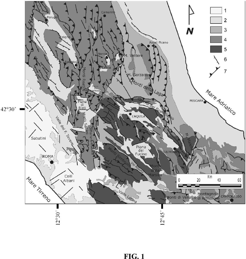
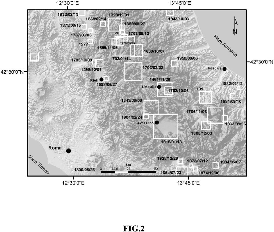
2 accurate estimation of the ongoing crustal deformation of this region. For this reason was planned and set up the Central Apennine Geodetic Network (CA-GeoNet), with mean distances between stations at 3-5 kilometres and capable to estimate the sub regional and near field strain rates across the main seismogenic structures and faults, which are supposed to drive the crustal dynamics of this area. Geological and structural setting The Apennines formed since the end of Miocene and developed in a chain-foredeepforeland dynamic system. They are characterized by the overlying of several mesozoic and cenozoic paleogeographic domains, NE migrating (Bigi et al., 1990; Calamita et al., 1999) (Fig.1). Since Miocene the Central Apennines displayed several tectonic phases and the geological units of the Umbria-Marche area were bended and thrusted on those of the laziale-abruzzese carbonatic platform. The latter have been subsequently thrusted on the Marche- Abruzzo formations. All these structures defines a thrust edifice NW-SE trending, with N-S dextral and WNW-ESE left lateral strike slip systems (Alfonsi et al., 1991; Catalano et al., 1993; Mattei, 1995; Corrado et al., 1997), as evidenced by independent geophysical data (Speranza et al., 1997). Since upper Pliocene and lower Pleistocene, the Apennines underwent to an extensional tectonic phase that produced NW-SE trending normal faults (Bigi et al., 1990; Calamita et al., 1999; Calamita et al., 1994a,b). The combined action of the Plio-quaternary faults produced several intermontane basins, filled with continental deposits. These basins are of great importance for the assessment of the Quaternary tectonics because the largest earthquakes and active tectonics are located within these zones (Bosi et al., 1975; Lavecchia et al., 1994; Boschi et al., 1995; Cello et al., 1997; Calamita et al., 1999; Boschi et al., 1999; Galadini e Galli, 2000; Galadini e Messina, 2001; Valensise and Pantosti, 2001). The Umbria Marche area, displays Mesozoic and Cenozoic formations (limestones with silica and marls) NE-ward bended and thrusted, with axis ranging from NW-SE to NNE-SSW in the northern and southern sectors, respectively. The Quaternary faults downlifted SW-ward trending blocks, (Calamita et al., 1999) and the sedimentary basins (Fig.2). The Lazio Abruzzo sector, which consists in Mesozoic and Cenozoic cabonatic units NW-SE thrusted with E-W trending planes (Accordi e Carbone, 1988; Ghisetti e Vezzani, 1990), during Quaternary experienced extensional tectonics that produced normal faults (Ghisetti e Vezzani, 1996). Active faults, with geological slip rates up to 1 mm/yr (Barchi et al., 2000; Valensise and Pantosti, 2001; Galadini e Galli, 2000) have been identified in this area. High angle faults systems, NW-SE striking, are located in the external sector of the Apennine chain (Southern Laga, Sibillini and Gran Sasso Mts.) and produced differential lowering toward SE. Active faults border the Quaternary basins of Amatrice and Campotosto (Bigi et al., 1990; Barchi et al., 2000; Valensise and Pantosti, 2001; Galadini e Galli, 2000). Seismicity The seismicity of the Central Apennines, known by historical information and modern instrumental recordings, shows maximum magnitudes at 7.1 and macroseismic intensities up to XI MCS scale (Postpischl, 1985; Westaway, 1992; Boschi et al., 1995; Boschi et al., 1998; Boschi et al., 1999) (Fig.2). Among the largest earthquakes that struck this region during the last two millennia, the 1703 seismic sequence is the most remarkable. Although the spatial and temporal evolution of this sequence is still a debated matter, the main shocks occurred in a wide area between Norcia and L Aquila with intensities up to XI MCS and produced large damages and casualties. Finally, in

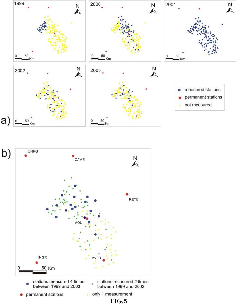
3 1915, the Fucino area was subjected to a M=7.1 (XI MCS) destructive seismic event, with epicentral location near Avezzano (Boschi et al., 1995). In recent times, from crustal and subcrustal earthquakes, Amato and Selvaggi (1992), defined three main seismogenetic belts in the central Apennines: the first running along the western margin (Tyrrhenian), with earthquake hypocentres <7km and high geothermal gradients; the second within the chain, with extensional mechanisms and hypocentres between 5 and 15 km; the last, which is the less active and release minor energy, borders the Adriatic sea and displays compressive and strike slip earthquakes. The maximum seismic energy is released in the inner part of the chain, along a belt NNW-SSE striking and 50-60km width. It is worth nothing that in the Umbria-Marche region, deep earthquakes have been located up to 90 km depth, supporting the hypothesis of a subducting adriatic litosphere under peninsular Italy. This seems in agreement with seismic tomography data, although a lack of deep seismicity in the other sectors of the central Apennines prevented to extrapolate this interpretation to the whole chain (Amato et al., 1993; Spakman, 1990). The instrumental seismicity recorded during the time span (Fig.3a), is mainly located in the Umbria- Marche area and along the Olevano Antrodoco Posta structural lineament (Salvini e Vittori, 1982). The former is addressed to the Umbria Marche 1997 seismic sequence, while the the latter is located along the border between the regional tectonic structures of the Umbria-Marche-Sabina in the West and of the Gran Sasso in the East (Fig.1). The available focal mechanisms of the largest earthquakes occurred in the time span (Gasparini et al., 1985) and the seismic sequences of Norcia, in 1979 (Deschamps et al., 1984), Lazio Abruzzo, in 1984 (Westaway et al., 1989) and Colfiorito, in 1997 (Amato et al., 1998), show a general extensional tectonic regime, with T axis NE-SW trending (Frepoli and Amato, 1997; Montone et al., 1997). After these earthquakes, the region was subjected only to a few low energy seismic events, especially during the time span (Fig.3b), the same epochs of the GPS surveys. The Ca-Geonet and GPS campaigns The CA-GeoNet, established in 1999 and completed in 2001, consists in 124 GPS stations, distributed with an average grid at 3-5 km (Anzidei et al., 2003). Siting was performed taking into account the geological and structural features of the region, and the geodetic benchmarks have been located on significant outcropping units. The largest part of the GPS stations are located across the Plio-quaternary basins and the main seismogenic sources, inferred from geological and seismological data (Valensise and Pantosti, 2001) (Fig.4). We used 3-D type GPS monuments for the 125 not permanent stations. The network includes 7 permanent GPS stations managed by the Italian Space Agency (AQUI, CAME, UNPG) and by the Istituto Nazionale di Geofisica and Vulcanologia (INGR, VVLO, RSTO, INGP). During the time span all the stations of the network have been occupied and 23 of them have been repeatedly measured during at least three campaigns. We used Trimble 4000SSi dual frequency receivers, equipped with Trimble L1/L2 Ground Plane geodetic antenna ( type). Surveys have been rigorously planned taking into account network grid, number of station to be measured simultaneously (up to 11), and time required to move receivers through the network. Each station has been occupied for an average observation window of 48 hours, for at least two survey session per station. GPS data were collected at 30 sec. sample rate during each observation session of at least 12 to 24 hours duration. To constrain the daily solutions and to include the

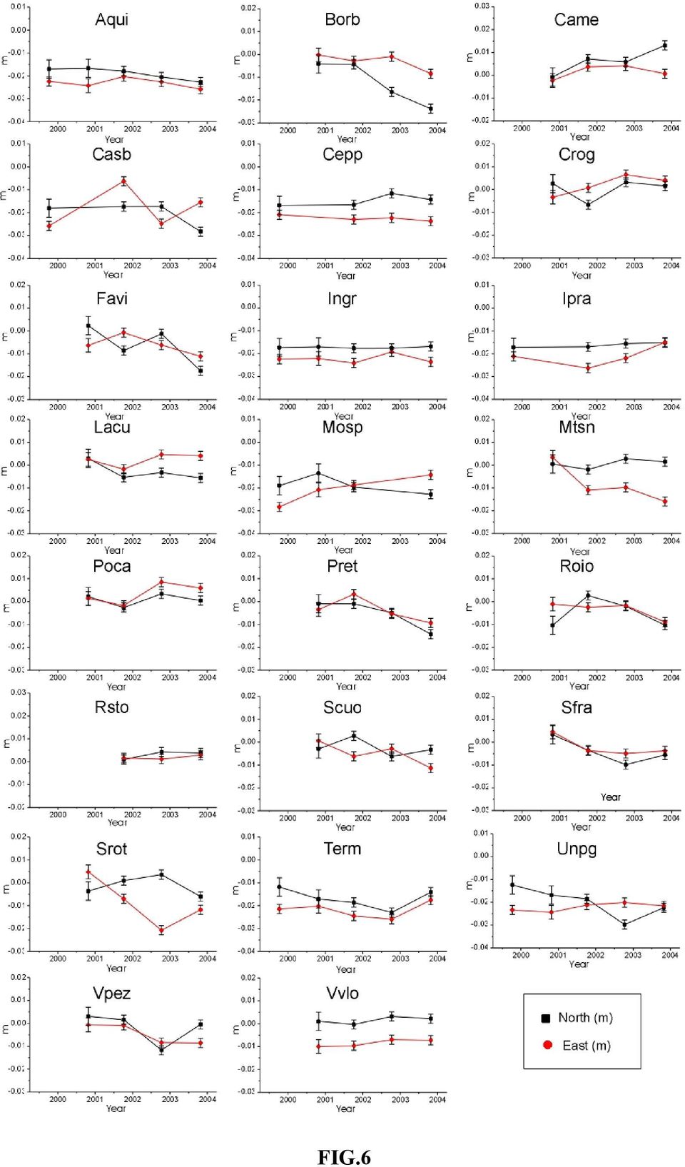
4 network in a unique reference frame, we used data collected at permanent stations (CAME, UNPG, AQUI, RSTO, INGR, VVLO and INGP); moreover for the whole campaign duration, TERM and PRET stations continuously operated as semipermanent stations. GPS data processing, velocity field and strain analysis The GPS data have been processed by means of the Bernese 4.2 software, performing the following steps: generation of satellite orbits using precise ephemeredes from CODE (Center of Orbit Determination); computation of the best value for point positions from code pseudo-range observables and receiver clocks correction; creation of undifferenced phase data from receiver carrier phase readings; creation of single difference phase data and computation of their correlations; coordinate estimation from triple-differences processing and cycle slips detection; computation of the doubledifference solution solving for baseline components and real phase ambiguity values; integer ambiguity values estimation (iterative procedure); computation of the fixed bias solution starting from previous estimates, adopting different acceptance or rejection criteria. The strategy used for baselines computation (step 3) was based on network geometry and station distribution, taking into account measurement sessions. Single difference daily observations were formed between the available fiducial stations, continuously operating during the campaign, to the other CAGeoNet stations. The tropospheric zenith delay was computed and corrected using the standard Saastmoinen model and estimating a set of time-dependent parameters for each site. The elevationdependent antenna phase center corrections were applied, according to the IGS_1 model. The ionospheric effect was reduced introducing the estimation of the global TEC (Total Electronic Content) obtained by the L4 (geometry-free) linear combination analysis. The ambiguities were computed adopting the wide-lane technique. In the first step, the linear combination L5 was processed and the wide-lane ambiguities were stored; in the second, the L3 (iono-free) combination was used, the wide-lane ambiguities were introduced as known and the narrow-lane ambiguities were solved. Daily solutions were computed and combined for each campaign by a least-square sequential adjustment and finally combined (Koch, 1988). A free network solution approach was adopted to avoid distorsions (Brockmann and Gurtner, 1996). In table 1 are listed the root mean square values of daily solutions with respect to the adjusted values for each campaign, providing the repeatability of the North, East and Up components. To estimate velocities at the CAGeoNet stations, we combined the normal equations solutions of the four campaigns, adding new station parameters: coordinates at reference epochs and mean velocities (Tab.2). Fig. 6 shows the time series for the North and East components of 23 stations of the network. Values are referred to INGR station. The strain rate estimation was performed by a least square adjustment under the uniform field condition, using station velocities as observables. U 1 0 x1 y1 0 0 u1 V x1 y1 v1 L11 M M M M M M = M L x1 y1 0 0 un L x1 y1 vn L22 The velocity gradient tensor was computed and its strain and rotational parts separated. Eigenvalues were obtained from matrix diagonalization, providing strain rate values along the two principal axis (E max, E min ) and the orientation (azimuth ϕ).

5 E E max min ϕ = L arctg L ( L L ) + ( L L ) = L L ( L L ) + ( L L ) = L L L L The procedure was applied to different data set, as shown in figure 7, using as fiducial stations AQUI, CAME, INGR, PRET, RSTO, TERM, UNPG and VVLO stations. Our results show an extensional behaviour of the chain, in agreement with geological and seismic data, and a significant compression in its inner part. Strain rates are ranging from 12x10-9 ±11yr -1 to 16x10-9 ±11yr -1 and from -14x10-9 ±11yr -1 to -3x10⁻⁹ ±11yr -1, normal and along the chain axis, respectively. The computed deformation trend represents a significant improvement of earlier results published in previous papers by D Agostino et al. (2001) from the reoccupation of part of the IGM95 network (Surace, 1993; 1997), by Serpelloni et al. (2001) and Anzidei et al. (2001) from the Tyrgeonet and GeoModAp networks, by Hunstad and England (1999) and Hunstad et al. (2003) from historical IGM triangulation network. These previous geodetic studies estimate maximum strain rates for the Central Apennines at 180±30 x 10-9 (D Agostino et al. 2001), 57±13 x 10-9 (Caporali et al., 2003), from 3.7±29 x 10-9 to 116±32 x 10-9 (Hunstad et al., 2003), 4.1±0.8 x 10⁻⁹ (Ward, 1994), 31±8 x 10⁻⁹ (Serpelloni et al., 2002), generally higher but with similar strikes with respect to those shown in this paper. The different time span used in the data, the available data set, the network size, geometry and finally the number of stations analysed, can be partially responsible of such differences in the obtained results. Conclusions Our data provide a more detailed view on the present-day sub-regional and near deformation field of this region, thanks to the high number of stations and the short baselines (3-5 km) among stations. The striking of the strain axes show that the area is undergoing to an active deformation with NE-SW prevailing extension, normal to the chain. No relevant seismic activity occurred in the last years in the surveyed area, even if the region experienced destructive earthquakes in the past. Moreover if the post-seismic deformations related with the last largest earthquakes (Fucino, 1915, Ms=6.9 and Umbria-Marche, 1997, Ms=5.9), located in the southernmost and northernmost sides of the network respectively, are ended or weak and confined within a few km across the fault (Aoudia et al., 2003), the observed deformation is interseismic, thus describing the regional and purely elastic deformation field of the region. The extensional behaviour of the area, normal to the chain, is in agreement with the distribution and trend of the main seismogenic sources reported in Valensise and Pantosti (2001) that could play a major role in the observed deformations and in the kinematic of the peninsular Italy. New surveys, planned in 2004 to add new velocity data, will improve the knowledge of the active strain rate estimation in this high risk seismic area. The local deformation field, that can be representative of the accumulating deformation on the faults, will allow to estimate the present day slip rate related with the single faults or structures and to distinguish their temporal and spatial variations from repeated surveys. The network grid at 3-5 km, which is optimal with respect to the average seismogenic fault size of the central Apennines, will allow to obtain affordable geodetic 2 2

6 data to constrain eventual coseimic dislocation models. Finally the combination with DinSAR data will provide an accurate spatial deformation pattern of this region, related with seismic cycle (Massonnet D. et al., 1993; Massonnet et al., 1996), as recently performed in the Apennines during the 1997 Umbria-Marche earthquakes 1997 (Hustad et al., 1998; Anzidei et al., 1999; Stramondo et al., 1999; Salvi et al., 2000). Ackowledgments This reasearch has been performed under the Italian Space Agency Project Applicazione delle tecniche spaziali per la valutazione del campo di deformazione crostale e della pericolosita` sismica dell'appennino centro meridionale. We are thankful to Prof. Enzo Boschi who encouraged this work, Dr. Paolo Marsan, of the National Seismic Service who made available the occupation of the Aquilano Geodetic Network, Dr. Andrea Tertulliani for the helpful scientific discussion on the historical seismicity. A special thanks to Mr. Sergio Del Mese and Angelo Massuci for their valuable collaboration during site reconoissance and field surveys. References Alfonsi L., R. Funiciello, and M. Mattei (1991): Strike-slip tectonics in the Sabina area. Boll. Soc. Geol. It. 110, Amato A. and G. Selvaggi G. (1992): Terremoti crostali e subcrostali nell'appennino settentrionale. Studi Geologici Camerti, vol. spec. 1991/1, Amato A., Alessandrini B., Cimini G.B., Frepoli A. and Selvaggi G. (1993): Active and remnant subducted slabs beneath Italy: evidence from seismic tomography and seismicity, Ann. Geofis., 36, Amato A., Azzara R., Chiarabba C., Cimini G.B., Cocco M., Di Bona M., Margheriti L., Mazza S., Mele F., Selvaggi G., Basili A., Boschi E., Courboulex F., Deschamps A., Gaffet S., Bittarelli G., Chiaraluce L., Piccinini D. & Ripepe M. (1998) - The 1997 Umbria-Marche, Italy, earthquake sequence: a first look at the main shocks and aftershocks. Geophys. Res. Lett., 25, NO.15, Anzidei M., Baldi P., Galvani A., Pesci A., Hunstad I. and E.Boschi (1999): Coseismic displacement of the 26th september 1997 Umbria - Marche (Italy) earthquakes detected by GPS: campaigns and data. Annali di Geofisica, vol.42, n.4, Anzidei M., Baldi P., Casula G., Galvani A., Mantovani E., Pesci A., Riguzzi F., Serpelloni E. (2001): Insights on present-day crustal motion in the Central Mediterranean area from GPS surveys. Geophysical Journal International, vol. 146, Anzidei, M., Galvani, A., Esposito, A., Cristofoletti, P., Pesci, A., Baldi, P., Casula., G., Cenni, N., Loddo, F., Serpelloni, E. (2003): The Central Apennine Geodetic Network (CA-Geonet): description and preliminary results, Geophysical Research Abstracts, XXVIII European Geophysical Society General Assembly, Vol. 5, Abstract EAE03-A

7 Aoudia A., A. Borghi, R. Riva, R. Barzaghi, B. A. C. Ambrosius, R. Sabadini, L. L. A. Vermeersen and G. F. Panza (2003). Postseismic deformation following the 1997 Umbria-Marche (Italy) moderate normal faulting earthquakes. Geoph. Res. Lett., Vol. 30, 7, Barchi M., Galadini F., Lavecchia G., Messina P., Michettti A.M., Peruzza L., Pizzi A., Tondi E., e Vittori E. (2000). Sintesi delle conoscenze sulle faglie attive in Italia centrale: parametrizzazione ai fini della caratterizzazione dela pericolosità sismica. CNR Gruppo Nazionale per la Difesa dai terremoti Roma, 62pp. Basili R., Galadini F. e Messina P. (1999). The applicatiion of palaeolandsurface analysis to the study of recent tectonics in central Italy. In Uplift, Erosion and Stability: perspectives on long-term landscape development, a curu by Smith, B.J., Whalley W. B., & Warke P. A.. Geological Society, London Special pubblications, 162, Bigi G., Cosentino D., Partotto M., Sartori R. e Scandone P. (1990). Structural model of Italy (scala 1: ) sheet n.4. CNR-PFG. Boschi E., Ferrari G., Gasperini P., Guidoboni E., Smriglio G. & Valensise G. (1995) - Catalogo dei forti terremoti in Italia dal 461 a.c. al1980. Istituto Nazionale di Geofisica (ING) e Storia Geofisica Ambiente (SGA). Boschi E., Guidoboni E., Ferrari G., Valensise G. (1998): I terremoti dell Appennino Umbro-Marchigiano. Area sud orientale dal 99 a.c. al Istituto Nazionale di Geofisica, SGA Storia Geofisica Ambiente. 267 pp. Boschi E., Gasperini P., Valensise G., camassi R., Castelli V., Stucchi M., Rebez A., Monachesi G., Barbano M.S., Albini P., Guidoboni E., Ferrari G., Mariotti D., Comassi A., Molin D. (1999): Catalogo parametrico dei terremoti italiani. Editrice Compositori Bosi C. (1975). Osservazioni preliminari su faglie probabilmente attive nell Appennino centrale. Boll. Soc. Geol. It. 94, , 28 ff., 1 tav.. Blumetti A.M., Cavinato G.P. e Tallini M. (1996). Evoluzione plio-quaternaria della conca di L Aquila-Scoppito: studio preliminare. Il Quaternario, 9 (1), Blumetti A.M., Dramis F. e Michetti A.M. (1993). Fault-generated mountain fronts in the central Apennines (central Italy): geomorphological features and seismotectonic implications. Earth Surface Processes and landforms, 18, Brockmann, E., and W. Gurtner (1996), Combination of GPS Solutions for Densification of European Network: Concepts and Results Derived from 5 European Associated Analysis Centers of the IGS, in EUREF workshop, Ankara, May Calamita F., Coltorti M., Pieruccini P. e Pizzi A. (1999). Evoluzione strutturale e morfogenesi plio-quaternaria dell Appennino umbro-marchigiano tra il preappennino umbro e la costa adriatica. Boll. Soc. Geol. It. 118, ,6 ff. Calamita F., Cello G., Deiana G. & Paltrinieri W. (1994a) - Structural styles, chronology rates of deformation, and time-space relationships in the Umbria-Marche thrust system (central Apennines, Italy). Tectonics, 13,

8 Calamita F., Coltorti M., Farabollini P. & Pizzi A. (1994b) - Le faglie normali quaternarie nella Dorsale appenninica umbro-marchigiana. Proposta di un modello di tettonica d'inversione. Stud. Geol. Camerti. Vol. Spec., 1994, Caporali A., Martin S., Massironi M. (2003) Average strain rate in the Italian crust inferred from a permanent GPS network - II. Strain rate versus seismicity and structural geology. Geophys. Journal International, 155, D'Agostino N., Giuliani R., Mattone M., and Bonci L. (2001) Active crustal extension in the central Apennines (Italy) inferred from GPS measurements in the interval Geophys. Res. Lett., 28,10, Deschamps A., Iannaccone G. & Scarpa R. (1984) - The Umbrian earthquake (Italy) of 19 September 1979, Ann. Geophys., 2, Frepoli A. & A. Amato (1997) - Contemporaneous extension and compression in the North Apennines from earthquake fault plane solutions, Geophys. J. Int., 129, Gasparini C., Iannaccone G. & Scarpa R. (1985) - Fault-plane solutions and seismicity of the Italian Peninsula, Tectonophysics, 117, Galadini F. e Galli P. (2000). Active tectonics in the central Apennines (Italy) input data for seismic hazard assessment. Natural Hazard 22, Galadini F. e Messina P. (1993). Stratigrafia dei depositi continentali, tettonica ed evoluzione geologica quaternaria dell Alta Valle del fiume Sangro (Abruzzo meridionale). Boll. Soc. Geol. It. 112, , 10 ff., 1 tav. f.t.. Ghisetti F. e Vezzani L. (1996). Geometrie deformative ed evoluzione cinematica dell Appennino centrale. Studi Geol. Camerti. XIV, Ghisetti F. e Vezzani L. (1990). Stili strutturali nei sistemi di sovrascorrimento dellacatena del Gran sasso (Appennino centrale). Studi Geol. Camerti. Vol. spec., Hunstad I., Anzidei M., Baldi P. Cocco M., Galvani A., Pesci A. (1998): Modelling Coseismic displacements during the 1997 Umbria-Marche earthquake (Central Italy). Geoph. Jou. Int., 139, Hunstad I. and P. England (1999): An upper bound on the rate of strain in the central Apennines, Italy, from triangulation measurements between 1869 and Earth and Planetary Science Letters, 169, Hunstad I., Selvaggi G., D'Agostino N., England P., Clarke P. and Pierozzi M. (2003): Geodetic strain in peninsular Italy between 1875 and 2001 Geophysical Research Letters, 30, (4), Koch, K.R. (1988), Parameter estimation and hypotesis testing in linear models, Springer, Berlin Heidelberg New York.
 Active crustal extension in the central Apennines (Italy) inferred from GPS measurements in the interval 1994-1999. Geophys. Res. Lett., 28,10,2121-2124 Deschamps A., Iannaccone G. & Scarpa R.")
9 Mazzoli S., Corrado S., De Donatis M., Scrocca D., Butler D.W.H., Di Bucci D., Naso G., Nicolai C. e Zucconi V. (1997). Time and space variability of the thin-skinned and thick-skinned thrust tectonics in the Apennines (Italy). Rend. Fis. Acc. Lincei s. 9, v. 11, 5-39 Montone P., Amato A., Frepoli A., Mariucci M.T. & Cesaro M. (1997) - Crustal stress regime in Italy. Ann. di Geofis., 40, 3, Pantosti D., D Addezio G., e Cinti F.R. (1996). Paleoseismicity of the Ovindoli-Pezza fault, central Apennines, Italy: a history including a large, previously unrecord earthquake in the Middle Ages ( A.D.). J. Geophys. Res. 101, Peruzza L. (1999): Progetto MISHA. Metodi innovativi per la stima dell hazard: applicazione all Italia centrale. CNR-Gruppo Nazionale per la Difesa dei Terremoti, Roma, 176 pp. Postpischl D. (1985) - Catalogo dei terremoti italiani dall'anno 1000 al Quaderni de "La Ricerca Scientifica", CNR-PFG, 114, vol. 2B, Roma. Salvi S., S. Stramondo, M. Cocco, E. Sansosti, I. Hunstad, M. Anzidei, P. Briole, P. Baldi, M. Tesauro, E. Lanari, F. Doumaz, A. Galvani, A. Pesci (2000): MODELLING COSEISMIC DISPLACEMENT RESULTING FROM SAR INTERFEROMETRY AND GPS MEASUREMENTS DURING THE 1997 UMBRIA MARCHE SEISMIC SEQUENCE Journal of Seismology,4, Salvini F. & Vittori E. (1982) - Analisi strutturale della linea Olevano-Antrodoco-Posta (Ancona-Anzio Auct): metodologie di studio delle deformazioni fragili e presentazione del tratto meridionale. Mem. Soc. Geol. It., 24, Serpelloni E., Anzidei M., Baldi P., Casula G., Galvani A., Pesci A., Riguzzi F. (2001): Geodetic measurement of crustal deformations in central-southern Apennines (Italy). Annali di Geofisica, vol.44, n.3, Serpelloni E., Anzidei M., Baldi P., Casula G., Galvani A., Pesci A. & Riguzzi F.(2002): Combination of permanent and non-permanent GPS networks for the evaluation of the strain-rate field in the central Mediterranean area. Bollettino di Geofisica Teorica ed Applicata, Vol.43, n.3-4, Spakman W. (1990) - Tomographic images of the upper mantle below central Europe and the Mediterranean, Terra Nova, 2, Stramondo S., Tesauro M., Briole P., Sansosti E., Salvi S., Lanari R., Anzidei M., Baldi P., Fornaro G., Avallone A., Buongiorno M.F., Franceschetti G., Boschi E.(1999): The September 26,1997 Central Italy earthquakes: coseismic surface displacement detected by sar interferometry and GPS, and fault modeling. Geophysical Research Letters, vol.26, n.7, pp Surace L. (1993): Il progetto IGM95. Bollettino di Geodesia e Scienze Affini 3, Surace L. (1997): La nuova rete geodetica nazionale IGM95: risultati e prospettive di utilizzazione. Bollettino di Geodesia e Scienze Affini 3,
. J. Geophys. Res. 101, 5937-5959.")
10 Valensise L. and Pantosti D. (2001): Database of Potential Sources For Earthquakes Larger Than M=5.5 in Italy. Annali di Geofisica, vol.44, suppl.1, with CD-ROM Ward S.N. (1994): Constraints on the seismotectonics of the Central Mediterranean sea from Very Long Baseline Interferometry. Geohys. Jour. International, 117, Wells and Coppersmith (1994): New empirical relationships among magnitude, rupture length, rupture width and surface displacements. Bullettin of Sesmological Society of America, 84 (4), Westaway R., Gawthorpe R. & Tozzi M. (1989) - Seismological and field observations of the 1984 Lazio-Abruzzo earthquakes: implications for the active tectonics of Italy, Geophys. J. R. astr. Soc., 98, Westaway R. (1992) - Seismic moment summation for historical earthquakes in Italy: tectonic implication. Jour. of Geophys. Res., 97, B11,
 - Seismological and field observations of the 1984 Lazio-Abruzzo earthquakes: implications for the active tectonics of Italy, Geophys. J. R. astr. Soc.")
11 FIGURE CAPTIONS Fig.1 Geological and structural sketch of the central Apennines (modified from Mazzoli et al., 1997; Cello et al., 1997). Fig. 2 Historical seismicity of the central Appennine from 179 B.C. to 1979 and Intensities VIII MCS (from Boschi et al., 1995; Boshi et al., 1998; Boschi et al.,1999). Fig.3 Instrumental seismicity during the time span a) and b) (Ml>3.0 from the INGV Seismic Bullettin). Fig.4 Distribution of the CA-GeoNet stations with respect to the seimogenetic sources, as reported in Valensise and Pantosti (2001). Fig.5 Sketch of the CA-GeoNet occupations during the repeated campaigns performed in the time span : a) distribution of measured station for each campaign; b) state of the art: blue circles display the stations measured at least three times between 1999 and Fig. 6 Horizontal GPS position time series, for the North (N), East (E) components with respect to INGR station. Fig. 7 Velocity (black arrows) and strain (double blue and red arrow) fields, estimated during the time span , after four repeated campaigns (red dots permanent stations and green dots non permanent stations). Max strain is at 16x10-9 ±11 yr -1 ; min strain is at -14x10-9 ±11 yr -1. Seismogenic sources from Valensise and Pantosti (2001).
. Fig.")
12 TABLE CAPTIONS Table 1 Root mean values of the daily solutions with respect to the adjusted values of each campaign. Tab 2 GPS site velocities (mm/yr) and related errors at 95% confidence level, computed with respect to the continuous monitoring INGR station. Data estimated after four repeated campaigns ( ).

13 FIG. 1
14 FIG.2
15 a b FIG. 3

16 FIG.4

17 FIG.5
18 FIG.6
19 FIG.7

20 year North East Up (mm) (mm) (mm) Table 1

21 CaGeoNet relative velocity field respect to INGR station Num Station V E V N (mm/yr) (mm/yr) 4 AQUI -1.7 ± ± BORB -7.9 ± ± CAME 4.1 ± ± CASB -2.3 ± ± CEPP 1.3 ± ± CROG 0.9 ± ± FAVI -4.4 ± ± INGR 0.0 ± ± IPRA 0.7 ± ± LACU -2.3 ± ± MOSP -2.0 ± ± MTSN 0.6 ± ± POCA 0.3 ± ± PRET -2.8 ± ± ROFA -0.9 ± ± ROIO -2.0 ± ± SCUO -1.7 ± ± SFRA -3.0 ± ± SROT 0.0 ± ± TERM -1.2 ± ± VPEZ -2.7 ± ± VVLO 1.2 ± ± RSTO 1.5 ± ± UNPG -4.0 ± ± 0.2 TAB.2
Direttore Enzo Boschi
 Direttore Enzo Boschi Editorial Board Raffaele Azzaro (CT) Sara Barsotti (PI) Viviana Castelli (MI) Anna Grazia Chiodetti (AC) Rosa Anna Corsaro (CT) Luigi Cucci (RM1) Mauro Di Vito (NA) Sergio Gurrieri
Imaging the polarity switch between large seismogenic normal faults in the southern Apennines (Italy)
") Trabajos de Geología, Universidad de Oviedo, 29 : 276-280 (2009) Imaging the polarity switch between large seismogenic normal faults in the southern Apennines (Italy) U. FRACASSI 1*, G. MILANO 2, R. DI
Trabajos de Geología, Universidad de Oviedo, 29 : 276-280 (2009) Imaging the polarity switch between large seismogenic normal faults in the southern Apennines (Italy) U. FRACASSI 1*, G. MILANO 2, R. DI
Plio-Quaternary tectonic evolution of the Northern Apennines thrust fronts. along the Bologna-Ferrara section (Po Plain, Italy), based on geological
, based on geological") Plio-Quaternary tectonic evolution of the Northern Apennines thrust fronts along the Bologna-Ferrara section (Po Plain, Italy), based on geological observations and analogue modelling: seismotectonic implications
Plio-Quaternary tectonic evolution of the Northern Apennines thrust fronts along the Bologna-Ferrara section (Po Plain, Italy), based on geological observations and analogue modelling: seismotectonic implications
ERMES. Monitoring of radon in geogas at the Gran Sasso National Laboratory
 ERMES. Monitoring of radon in geogas at the Gran Sasso National Laboratory G. De Luca a and W. Plastino b a Istituto Nazionale di Geofisica e Vulcanologia (INGV) Centro Nazionale Terremoti (CNT), Via di
FROM DRAWING ANTICLINE AXES TO 3D MODELLING OF SEISMOGENIC SOURCES: EVOLUTION OF SEISMOTECTONIC MAPPING IN THE PO PLAIN
 FROM DRAWING ANTICLINE AXES TO 3D MODELLING OF SEISMOGENIC SOURCES: EVOLUTION OF SEISMOTECTONIC MAPPING IN THE PO PLAIN Burrato P.*, Maesano F. E. *, D Ambrogi C.**, Toscani G., Valensise G.* (*) INGV,
Building 1D reference velocity model of the Irpinia region (Southern Apennines): microearthquakes locations and focal mechanism
: microearthquakes locations and focal mechanism") Building 1D reference velocity model of the Irpinia region (Southern Apennines): microearthquakes locations and focal mechanism Tutor Prof. Raffaella De Matteis PhD student Emanuela Matrullo Geophisics
Building 1D reference velocity model of the Irpinia region (Southern Apennines): microearthquakes locations and focal mechanism Tutor Prof. Raffaella De Matteis PhD student Emanuela Matrullo Geophisics
Geophysical Journal International
 Geophysical Journal International Geophys. J. Int. (2009) doi: 10.1111/j.1365-246X.2009.04418.x EXPRESS LETTER Seismic moment tensors of the April 2009, L Aquila (Central Italy), earthquake sequence S.
GPS/InSAR/PSInSAR Related Papers List (Out of Marmara Region)
") GPS/InSAR/PSInSAR Related Papers List (Out of Marmara Region) 1. S. Salvi, M.F. Buongiorno, F. Doumaz, S. Stramondo (1997) Contributo delle tecniche aerospaziali di osservazione della terra alla definizione
GPS/InSAR/PSInSAR Related Papers List (Out of Marmara Region) 1. S. Salvi, M.F. Buongiorno, F. Doumaz, S. Stramondo (1997) Contributo delle tecniche aerospaziali di osservazione della terra alla definizione
Geological analysis and seismic hazard in the Central Apennines (Italy)
") Journal of Geodynamics 29 (2000) 517±533 Geological analysis and seismic hazard in the Central Apennines (Italy) Emanuele Tondi Dipartimento di Scienze, della Terra UniversitaÁ di Camerino, Via Gentile
Journal of Geodynamics 29 (2000) 517±533 Geological analysis and seismic hazard in the Central Apennines (Italy) Emanuele Tondi Dipartimento di Scienze, della Terra UniversitaÁ di Camerino, Via Gentile
Mapping the Tyrrhenian and Adriatic Mohos across the northern and central Apennine chain through teleseismic receiver functions
 Mapping the Tyrrhenian and Adriatic Mohos across the northern and central Apennine chain through teleseismic receiver functions Giuliana Mele Istituto Nazionale di Geofisica e Vulcanologia - Roma, Italy
Early Middle Pleistocene eastward migration of the Abruzzi Apennine (central Italy) extensional domain
 extensional domain") Journal of Geodynamics 37 (2004) 57 81 www.elsevier.com/locate/jog Early Middle Pleistocene eastward migration of the Abruzzi Apennine (central Italy) extensional domain Fabrizio Galadini*, Paolo Messina
Journal of Geodynamics 37 (2004) 57 81 www.elsevier.com/locate/jog Early Middle Pleistocene eastward migration of the Abruzzi Apennine (central Italy) extensional domain Fabrizio Galadini*, Paolo Messina
Inversion modelling of ground deformation data: local minimum and volcanic sources shape
 Inversion modelling of ground deformation data: local minimum and volcanic sources shape Alessandro Spata XIX Brain Storming Day Dottorato di Ricerca in Ingegneria Elettronica, Automatica e del Controllo
2D gravity modelling along the CROP11 seismic profile
 Bollettino di Geofisica Teorica ed Applicata Vol. 47, n. 3, pp. 447-454; September 2006 2D gravity modelling along the CROP11 seismic profile M.M. TIBERTI 1 and L. ORLANDO 2 1 Istituto Nazionale di Geofisica
Tectonophysics 476 (2009) 252 268. Contents lists available at ScienceDirect. Tectonophysics. journal homepage: www.elsevier.
 252 268. Contents lists available at ScienceDirect. Tectonophysics. journal homepage: www.elsevier.") Tectonophysics 476 (2009) 252 268 Contents lists available at ScienceDirect Tectonophysics journal homepage: www.elsevier.com/locate/tecto Geomorphic signatures of recent normal fault activity versus geological
Tectonophysics 476 (2009) 252 268 Contents lists available at ScienceDirect Tectonophysics journal homepage: www.elsevier.com/locate/tecto Geomorphic signatures of recent normal fault activity versus geological
D. Di Bucci et al. / Journal of Geodynamics 40 (2005) 294 315 295
 294 315 295") Journal of Geodynamics 40 (2005) 294 315 Structural setting of the 1688 Sannio earthquake epicentral area (Southern Italy) from surface and subsurface data D. Di Bucci a,, B. Massa b, M. Tornaghi c, A.
Journal of Geodynamics 40 (2005) 294 315 Structural setting of the 1688 Sannio earthquake epicentral area (Southern Italy) from surface and subsurface data D. Di Bucci a,, B. Massa b, M. Tornaghi c, A.
12.510 Introduction to Seismology Spring 2008
 MIT OpenCourseWare http://ocw.mit.edu 12.510 Introduction to Seismology Spring 2008 For information about citing these materials or our Terms of Use, visit: http://ocw.mit.edu/terms. 04/30/2008 Today s
Integration between spaceand ground-based data sets: application on ground deformations measurements
 Integration between spaceand ground-based data sets: application on ground deformations measurements Giuseppe Puglisi Istituto Nazionale di Geofisica e Vulcanologia Sezione di Catania Osservatorio Etneo
Mean density map for the Italian region by GIS techniques
 BOLLETTINO DI GEOFISICA TEORICA ED APPLICATA VOL. 40, N. 3-4, pp. 477-482; SEP.-DEC. 1999 Mean density map for the Italian region by GIS techniques V. BAIOCCHI (1),M.CRESPI (1) and F. RIGUZZI (2) (1) DITS
Seismological, geological and geophysical constraints for the Gualdo Tadino fault, Umbria Marche Apennines (central Italy)
") Tectonophysics (5) 33 7 www.elsevier.com/locate/tecto Seismological, geological and geophysical constraints for the Gualdo Tadino fault, Umbria Marche Apennines (central Italy) M.G. Ciaccio a, *, M.R.
Tectonophysics (5) 33 7 www.elsevier.com/locate/tecto Seismological, geological and geophysical constraints for the Gualdo Tadino fault, Umbria Marche Apennines (central Italy) M.G. Ciaccio a, *, M.R.
Active tectonics of Utah Version 1.0, March 2002 E. Calais
 Active tectonics of Utah Version 1.0, March 2002 E. Calais The transition between the Basin and Range and the Colorado Plateau Utah is located at the transition between the Colorado plateau and the Basin
Giancarlo Molli. Dipartimento Scienze della Terra Università di Pisa Via S.Maria 53, 56126 Pisa (Italia) Key words main topics:
 Key words main topics:") Giancarlo Molli Dipartimento Scienze della Terra Università di Pisa Via S.Maria 53, 56126 Pisa (Italia) Key words main topics: tectonics orogenic processes deformation structures and kinematics Regional
Giancarlo Molli Dipartimento Scienze della Terra Università di Pisa Via S.Maria 53, 56126 Pisa (Italia) Key words main topics: tectonics orogenic processes deformation structures and kinematics Regional
Kinematic model of active extension across the Umbria-Marche Apennines from GPS measurements: fault slip-rates and interseismic
 GNGTS 2013 Sessione 1.2 Kinematic model of active extension across the Umbria-Marche Apennines from GPS measurements: fault slip-rates and interseismic coupling of the Alto Tiberina low-angle normal fault
Seismic hazard in the Po Plain and the 2012 Emilia earthquakes
 2012 EMILIA EARTHQUAKES ANNALS OF GEOPHYSICS, 55, 4, 2012; doi: 10.4401/ag-6158 Seismic hazard in the Po Plain and the 2012 Emilia earthquakes Carlo Meletti, Vera D'Amico, Gabriele Ameri, Andrea Rovida,
Magnitude 7.2 GUERRERO, MEXICO
 A powerful magnitude-7.2 earthquake shook central and southern Mexico on Friday. The earthquake occurred at a depth of 24 km (15 miles). Its epicenter was in the western state of Guerrero, near the seaside
MOHO DEPTH AND CRUSTAL STRUCTURE IN PENINSULAR ITALY
 MOHO DEPTH AND CRUSTAL STRUCTURE IN PENINSULAR ITALY Neutrino Geoscience 2010 Alessandro Amato Istituto Nazionale di Geofisica e Vulcanologia Talk outline Italy: tectonic setting and deep structures Moho
DEEP AZIMUTHAL SEISMIC ANISOTROPY IN THE WESTERNANATOLIA AND AEGEAN SUBDUCTION ZONE
 DEEP AZIMUTHAL SEISMIC ANISOTROPY IN THE WESTERNANATOLIA AND AEGEAN SUBDUCTION ZONE G. Polat -1 and M.N. Ozel -1 Adress: 1- Boğaziçi University, Kandilli Observatory and Earthquake Research Institution,
How Did These Ocean Features and Continental Margins Form?
 298 10.14 INVESTIGATION How Did These Ocean Features and Continental Margins Form? The terrain below contains various features on the seafloor, as well as parts of three continents. Some general observations
IAG/AIG-WG-TG Summer School 2016 on Alps vs Apennines: Tectonic Geomorphology of Mountains
 IAG/AIG-WG-TG Summer School 2016 on Alps vs Apennines: Tectonic Geomorphology of Mountains Italy: Western Alps (Peveragno, CN) Central Apennines (Assergi, AQ) July 2-9, 2016 SECOND CIRCULAR Aim and scope
EMERGEO Working Group*
 Technologies and new approaches used by the INGV EMERGEO Working Group for real time data sourcing and processing during the Emilia Romagna (Northern Italy) 2012 earthquake sequence. EMERGEO Working Group*
INITIAL RESULTS AT REDUCING SYSTEMATIC ERRORS FOR SEISMIC EVENT LOCATIONS USING A MODEL INCORPORATING ANISOTROPIC REGIONAL STRUCTURES
 INITIAL RESULTS AT REDUCING SYSTEMATIC ERRORS FOR SEISMIC EVENT LOCATIONS USING A MODEL INCORPORATING ANISOTROPIC REGIONAL STRUCTURES Gideon P. Smith and Douglas A. Wiens Washington University in St Louis
A temporary seismic monitoring of the Sulmona area (Abruzzo, Italy) for seismotectonic purposes
 for seismotectonic purposes") Bollettino di Geofisica Teorica ed Applicata DOI 10.4430/bgta0026 Vol. XX, n. x, pp. x-xx; Xxxxxxx XXXX A temporary seismic monitoring of the Sulmona area (Abruzzo, Italy) for seismotectonic purposes R.
Bollettino di Geofisica Teorica ed Applicata DOI 10.4430/bgta0026 Vol. XX, n. x, pp. x-xx; Xxxxxxx XXXX A temporary seismic monitoring of the Sulmona area (Abruzzo, Italy) for seismotectonic purposes R.
Displacement Field Estimation from GPS Measurements in the Volvi Area
 Displacement Field Estimation from GPS Measurements in the Volvi Area I. DOUKAS, A. FOTIOU, I. M. IFADIS, K. KATSAMBALOS, K. LAKAKIS, N. PETRIDOU CHRYSOHOIDOU, C. PIKRIDAS, D. ROSSIKOPOULOS, P. SAVVAIDIS,
IAG/AIG-WG-TG Summer School 2016 on Alps vs Apennines: Tectonic Geomorphology of Mountains
 IAG/AIG-WG-TG Summer School 2016 on Alps vs Apennines: Tectonic Geomorphology of Mountains Italy: Western Alps (Peveragno, CN) Central Apennines (Assergi, AQ) July 2-9, 2016 Aim and scope The IAG-WG-TG
Curriculum vitae of Matteo Spada (May 2010)
") Curriculum vitae of Matteo Spada (May 2010) Personal Information Name Matteo Spada Date of birth 26 September 1980 Citizen Marital status Vipiteno/Sterzing Bolzano/Bozen Married, 1 child My Picture Residence
Curriculum vitae of Matteo Spada (May 2010) Personal Information Name Matteo Spada Date of birth 26 September 1980 Citizen Marital status Vipiteno/Sterzing Bolzano/Bozen Married, 1 child My Picture Residence
La tettonica attiva nelle Alpi e la rete transnazionale di stazioni permanenti GPS
 La tettonica attiva nelle Alpi e la rete transnazionale di stazioni permanenti GPS Karim Aoudia Abdus Salam International Centre for theoretical Physics Earth System Physics Section GPS monitoring - monumentation
CO 2 storage science development and application in Italy
 CO 2 storage science development and application in Italy Salvatore Lombardi Carbon Sequestration Leadership Forum, 16-19 April 2013 Rome, Italy Objectives Site selection and characterization Acquisition
The CO2 Geological Storage: how it works Salvatore Lombardi
 The CO2 Geological Storage: how it works Salvatore Lombardi Carbonia, Centro Ricerche Sotacarbo, 27 novembre 2014 Contents of the presentation Notes on CO2 Geological Storage (CGS) How it works How we
The seismic activity in the area of Greece between 1966 and 1969
 The seismic activity in the area of Greece between 1966 and 1969 P. A. GIANNAKOPOULOS * Received on March 28'", 1972 SUMMARY. The earthquake activity in the area of Greece for the years 1966, 1967, 1968
GPS Precise Point Positioning with a Difference*
 GPS Precise Point Positioning with a Difference* Pierre Héroux and Jan Kouba Geodetic Survey Division, Geomatics Canada Natural Resources Canada 615 Booth Street Ottawa, Ontario K1A E9 heroux@geod.nrcan.gc.ca
Investigation 6: What happens when plates collide?
 Tectonics Investigation 6: Teacher Guide Investigation 6: What happens when plates collide? In this activity, students will use the distribution of earthquakes and volcanoes in a Web GIS to learn about
Exploring plate motion and deformation in California with GPS
 Exploring plate motion and deformation in California with GPS Student worksheet Cate Fox-Lent, UNAVCO master teacher; Andy Newman, Georgia Institute of Technology; Shelley Olds, UNAVCO; and revised by
Ground e ects and surface faulting in the September± October 1997 Umbria±Marche (Central Italy) seismic sequence
 seismic sequence") Journal of Geodynamics 29 (2000) 535±564 Ground e ects and surface faulting in the September± October 1997 Umbria±Marche (Central Italy) seismic sequence E. Vittori a, *, G. Deiana b, E. Esposito c, L.
Journal of Geodynamics 29 (2000) 535±564 Ground e ects and surface faulting in the September± October 1997 Umbria±Marche (Central Italy) seismic sequence E. Vittori a, *, G. Deiana b, E. Esposito c, L.
REDUCTION OF THE ECONOMIC-FINANCIAL EXPOSURE OF THE STATE AND PROTECTION OF HUMAN LIVES
 REDUCTION OF THE ECONOMIC-FINANCIAL EXPOSURE OF THE STATE AND PROTECTION OF HUMAN LIVES Models for the prevention and mitigation of damages to people and properties through an insurance coverage PRESENTATION
The Dynamic Crust 2) EVIDENCE FOR CRUSTAL MOVEMENT
 EVIDENCE FOR CRUSTAL MOVEMENT") The Dynamic Crust 1) Virtually everything you need to know about the interior of the earth can be found on page 10 of your reference tables. Take the time to become familiar with page 10 and everything
The Dynamic Crust 1) Virtually everything you need to know about the interior of the earth can be found on page 10 of your reference tables. Take the time to become familiar with page 10 and everything
The CO2 Geological Storage: how it works
 The CO2 Geological Storage: how it works Salvatore Lombardi Carbonia, Centro Ricerche Sotacarbo, 27 novembre 2014 Contents of the presentation Notes on CO2 Geological Storage (CGS) How it works How we
European Position Determination System. Guideline for EUPOS Reference Frame Fixing
 European Position Determination System Guideline for EUPOS Reference Frame Fixing Version 1.0 21 September 2007 Copyright: Publisher: 2007 by the International EUPOS Steering Committee Office of the International
Step 2: Learn where the nearest divergent boundaries are located.
 What happens when plates diverge? Plates spread apart, or diverge, from each other at divergent boundaries. At these boundaries new ocean crust is added to the Earth s surface and ocean basins are created.
Integrated surveying system for landslide monitoring, Valoria Landslide (Appennines of Modena, Italy)
") Integrated surveying system for landslide monitoring, Valoria Landslide (Appennines of Modena, Italy) Eleonora BERTACCHINI, Andrea CAPITANI, Alessandro CAPRA, Cristina CASTAGNETTI, Alessandro CORSINI,
Integrated surveying system for landslide monitoring, Valoria Landslide (Appennines of Modena, Italy) Eleonora BERTACCHINI, Andrea CAPITANI, Alessandro CAPRA, Cristina CASTAGNETTI, Alessandro CORSINI,
SCHOOL OF ADVANCED STUDIES- 2014 PhD Research topics
 SCHOOL OF ADVANCED STUDIES- 2014 PhD Research topics Area of Studies SCIENCE AND TECHNOLOGY Curriculum: Supervisors: Prof. Emanuele Tondi, Dr. Claudio Di Celma Research financed by grants: www.reachproject.com
CENTRO DI GEODESIA SPAZIALE MATERA. WIDE SURVEY OF THE MATERA SITE (August 98)
") CENTRO DI GEODESIA SPAZIALE MATERA WIDE SURVEY OF THE MATERA SITE (August 98) Doc. Nr.: 180.010-CSM-Errore. L'argomento parametro è sconosciuto. Date: 13/August/98 Function Name Date Signature Author D.
CENTRO DI GEODESIA SPAZIALE MATERA WIDE SURVEY OF THE MATERA SITE (August 98) Doc. Nr.: 180.010-CSM-Errore. L'argomento parametro è sconosciuto. Date: 13/August/98 Function Name Date Signature Author D.
EARTHQUAKE MAGNITUDE
 EARTHQUAKE MAGNITUDE Earliest measure of earthquake size Dimensionless number measured various ways, including M L local magnitude m b body wave magnitude M s surface wave magnitude M w moment magnitude
Determination of the deformation style and state of stress of the Calabrian Arc
 Determination of the deformation style and state of stress of the Calabrian Arc Scientific coordinator: Prof. Riccardo Barzaghi Introduction During the last year, the researches of the four RU involved
SURVEYING WITH GPS. GPS has become a standard surveying technique in most surveying practices
 SURVEYING WITH GPS Key Words: Static, Fast-static, Kinematic, Pseudo- Kinematic, Real-time kinematic, Receiver Initialization, On The Fly (OTF), Baselines, Redundant baselines, Base Receiver, Rover GPS
Plate Tectonics. Introduction. Boundaries between crustal plates
 Plate Tectonics KEY WORDS: continental drift, seafloor spreading, plate tectonics, mid ocean ridge (MOR) system, spreading center, rise, divergent plate boundary, subduction zone, convergent plate boundary,
Plate Tectonics. Plate Tectonics The unifying concept of the Earth sciences. Continental Drift
 Plate Tectonics The unifying concept of the Earth sciences. The outer portion of the Earth is made up of about 20 distinct plates (~ 100 km thick), which move relative to each other This motion is what
Geodynamics Lecture 2 Kinematics of plate tectonics
 Geodynamics Lecture 2 Kinematics of plate tectonics Lecturer: David Whipp david.whipp@helsinki.fi! 4.9.2013 Geodynamics www.helsinki.fi/yliopisto 1 Goals of this lecture Present the three types of plate
Plate Tectonics: Big Ideas. Plate Tectonics. Plate Tectonics. The unifying concept of the Earth sciences.
 Plate Tectonics: Big Ideas Our understanding of Earth is continuously refined. Earth s systems are dynamic; they continually react to changing influences from geological, hydrological, physical, chemical,
Current position: full professor in Structural Geology, University of Toirno (Italy)
") PROF. RODOLFO CAROSI Curriculum Vitae Current position: full professor in Structural Geology, University of Toirno (Italy) Dipartimento di Scienze della Terra - Università di Torino Via Valperga Caluso,
PROF. RODOLFO CAROSI Curriculum Vitae Current position: full professor in Structural Geology, University of Toirno (Italy) Dipartimento di Scienze della Terra - Università di Torino Via Valperga Caluso,
GPS Receiver Test. Conducted by the Department of Mathematical Geodesy and Positioning Delft University of Technology
 GPS Receiver Test Conducted by the Department of Mathematical Geodesy and Positioning Delft University of Technology A. Amiri-Simkooei R. Kremers C. Tiberius May 24 Preface For the purpose of a receiver
Name: Date: Class: Finding Epicenters and Measuring Magnitudes Worksheet
 Example Answers Name: Date: Class: Finding Epicenters and Measuring Magnitudes Worksheet Objective: To use seismic data and an interactive simulation to triangulate the location and measure the magnitude
PROHITECH WP3 (Leader A. IBEN BRAHIM) A short Note on the Seismic Hazard in Israel
 A short Note on the Seismic Hazard in Israel") PROHITECH WP3 (Leader A. IBEN BRAHIM) A short Note on the Seismic Hazard in Israel Avigdor Rutenberg and Robert Levy Technion - Israel Institute of Technology, Haifa 32000, Israel Avi Shapira International
PROHITECH WP3 (Leader A. IBEN BRAHIM) A short Note on the Seismic Hazard in Israel Avigdor Rutenberg and Robert Levy Technion - Israel Institute of Technology, Haifa 32000, Israel Avi Shapira International
PI: Riccardo Lanari (IREA CNR) email:lanari.r@irea.cnr.it
 email:lanari.r@irea.cnr.it") On the exploitation and validation of COSMO-SkyMed interferometric SAR data for digital terrain modelling and surface deformation analysis in extensive urban areas (ID: 1441) Project partners: Istituto
On the exploitation and validation of COSMO-SkyMed interferometric SAR data for digital terrain modelling and surface deformation analysis in extensive urban areas (ID: 1441) Project partners: Istituto
Publications in journals
 Publications in journals Capuano, P., Russo, G., and Scarpa, R., 2013, P-wave velocity and density structure beneath Mt. Vesuvius: a magma body in the upper edifice?: Ann. Geophys., 56, 1-13, doi: 10.4401/ag-6443
HAMMER RelationsHips between meteo-climatic parameters and ground surface deformation time series in mountain environments
 SPECIAL PROJECT PP5 HAMMER RelationsHips between meteo-climatic parameters and ground surface deformation time series in mountain environments F. Ardizzone, P. Allasia, M. Cignetti, D. Giordan, A. Manconi,
Global Positioning System
 B. Hofmann-Wellenhof, H. Lichtenegger, and J. Collins Global Positioning System Theory and Practice Third, revised edition Springer-Verlag Wien New York Contents Abbreviations Numerical constants xix xxiii
Sedimentary Basins. Revision Material. Introduction. CE3A8 SMJ Geology for Engineers 1
 CE3A8 SMJ Geology for Engineers 1 Sedimentary Basins Revision Material This handout lists the topics covered in the two lectures on sedimentary basins and provides a few key diagrams. Either of the following
Maintenance and Densification of the Italian GNSS Network. DIPARTIMENTO DI GEOSCIENZE A. Caporali J. Zurutuza M. Bertocco R. Corso P.
 Maintenance and Densification of the Italian GNSS Network DIPARTIMENTO DI GEOSCIENZE A. Caporali J. Zurutuza M. Bertocco R. Corso P. Legovini Outline Maintenance and Densification of the Italian GNSS Network
Data in seismology: networks, instruments, current problems
 Data in seismology: networks, instruments, current problems Seismic networks, data centres, instruments Seismic Observables and their interrelations Seismic data acquisition parameters (sampling rates,
Locating the Epicenter and Determining the Magnitude of an Earthquake
 Locating the and Determining the Magnitude of an Earthquake Locating the Measuring the S-P time interval There are hundreds of seismic data recording stations throughout the United States and the rest
Günter Seeber. Satellite Geodesy 2nd completely revised and extended edition
 Günter Seeber Satellite Geodesy 2nd completely revised and extended edition Walter de Gruyter Berlin New York 2003 Contents Preface Abbreviations vii xvii 1 Introduction 1 1.1 Subject of Satellite Geodesy...
Orbital and atmospheric noise in InSAR data inferred from the global ERS1,2 and Envisat SAR data archives
 Category-1 proposal submitted to the European Space Agency Orbital and atmospheric noise in InSAR data inferred from the global ERS1,2 and Envisat SAR data archives Executive Summary We request the online
Plate Tectonics: Ridges, Transform Faults and Subduction Zones
 Plate Tectonics: Ridges, Transform Faults and Subduction Zones Goals of this exercise: 1. review the major physiographic features of the ocean basins 2. investigate the creation of oceanic crust at mid-ocean
CURRICULUM VITAE. Edoardo Del Pezzo January 18, 2012. Born in Naples, Italy, on march 16,1951. Nationality: Italian
 CURRICULUM VITAE Edoardo Del Pezzo January 18, 2012 1 Life. Born in Naples, Italy, on march 16,1951. Nationality: Italian Army service from August 1974 to September 1975. 2 Education. Undergraduate level
Chapter 34 Latest GNSS Results of the CMONOC Network and Its Application in Earthquake Monitoring
 Chapter 34 Latest GNSS Results of the CMONOC Network and Its Application in Earthquake Monitoring Junping Chen, Yize Zhang, Yibing Xie, Weijie Tan, Sainan Yang and Bin Wu Abstract Crustal Movement Observation
View. A New. Into Earth
 View A New Into Earth EarthScope is a bold undertaking to apply modern observational, analytical and telecommunications technologies to investigate the structure and evolution of the North American continent
1 Introduction. External Grant Award Number: 04HQGR0038. Title: Retrieval of high-resolution kinematic source parameters for large earthquakes
 External Grant Award Number: 04HQGR0038 Title: Retrieval of high-resolution kinematic source parameters for large earthquakes Author: Hong Kie Thio URS Group Inc. 566 El Dorado Street, 2 nd floor Pasadena,
Automated control procedures and first results from the temporary seismic monitoring of the 2012 Emilia Sequence
 Automated control procedures and first results from the temporary seismic monitoring of the 2012 Emilia Sequence Authors: Simone Marzorati 1, Simona Carannante 1, Marco Cattaneo 1, Ezio D'Alema 1, Massimo
ARTICLE IN PRESS. Quaternary International 173 174 (2007) 30 44
 30 44") Quaternary International 173 174 (2007) 30 44 Environmental effects from five historical earthquakes in southern Apennines (Italy) and macroseismic intensity assessment: Contribution to INQUA EEE Scale
Quaternary International 173 174 (2007) 30 44 Environmental effects from five historical earthquakes in southern Apennines (Italy) and macroseismic intensity assessment: Contribution to INQUA EEE Scale
THE 2004 SUMATRA EARTHQUAKE AND INDIAN OCEAN TSUNAMI: WHAT HAPPENED AND WHY
 Page 6 The Earth Scientist THE 2004 SUMATRA EARTHQUAKE AND INDIAN OCEAN TSUNAMI: WHAT HAPPENED AND WHY Seth Stein and Emile A. Okal Dept of Geological Sciences, Northwestern University, Evanston Illinois
Originally published as:
 Originally published as: Passarelli, L., Hainzl, S., Cesca, S., Maccaferri, F., Mucciarelli, M., Rößler, D., Corbi, F., Dahm, T., Rivalta, E. (2015): Aseismic transient driving the swarm-like seismic sequence
DYNAMIC CRUST: Unit 4 Exam Plate Tectonics and Earthquakes
 DYNAMIC CRUST: Unit 4 Exam Plate Tectonics and Earthquakes NAME: BLOCK: DATE: 1. Base your answer to the following question on The block diagram below shows the boundary between two tectonic plates. Which
Magnitude 8.8 OFFSHORE MAULE, CHILE
 A great 8.8-magnitude struck central Chile early Saturday. The quake hit 200 miles (325 kilometers) southwest of the capital Santiago. The epicenter was just 70 miles (115 kilometers) from Concepcion,
MOBILE MAPPING APPLICATIONS BASED ON THE CYPRUS PERMANENT GPS NETWORK. 54124, Greece.
 MOBILE MAPPING APPLICATIONS BASED ON THE CYPRUS PERMANENT GPS NETWORK E.Stylianidis 1, S. Spatalas 2, C. Pikridas 2, P. Patias 2 1 Geoimaging Ltd, 6 Georgios Seferis Str., 1075 Nicosia, Cyprus. 2 Faculty
GROUND RESPONSE OF KATHMANDU VALLEY ON THE BASIS OF MICROTREMORS
 GROUND RESPONSE OF KATHMANDU VALLEY ON THE BASIS OF MICROTREMORS MADHAB R PANDEY 1 SUMMARY Devastation of Kathmandu valley from historical earthquakes, the M8.3 Bihar - Nepal Great Earthquake of 1934 in
Pure and Applied Geophysics The seismotectonics of the Po Plain (northern Italy): tectonic diversity in a blind faulting domain
: tectonic diversity in a blind faulting domain") Pure and Applied Geophysics The seismotectonics of the Po Plain (northern Italy): tectonic diversity in a blind faulting domain --Manuscript Draft-- Manuscript Number: Full Title: Article Type: Keywords:
Pure and Applied Geophysics The seismotectonics of the Po Plain (northern Italy): tectonic diversity in a blind faulting domain --Manuscript Draft-- Manuscript Number: Full Title: Article Type: Keywords:
Estimation of radial sea currents in the northern Adriatic Sea close to the Venice Lagoon inlets #ID2141
 Estimation of radial sea currents in the northern Adriatic Sea close to the Venice Lagoon inlets #ID2141 ASI CSK Workshop Stefano Zecchetto ISAC-CNR, Uos Padova s.zecchetto@isac.cnr.it Gianfranco Fornaro
Operational Earthquake Forecasting
 Operational Earthquake Forecasting State of Knowledge and Guidelines for Utilization Report by the International Commission on Earthquake Forecasting for Civil Protection Submitted to the Department of
Soil type dependent spectral seismic hazard in Friuli-Venezia Giulia (NE Italy)
") Bollettino di Geofisica Teorica ed Applicata Vol. 42, n. 1-2, pp. 121-138; Mar.-Jun. 2001 Soil type dependent spectral seismic hazard in Friuli-Venezia Giulia (NE Italy) A. Rebez (1), G.B. Carulli (2),
Bollettino di Geofisica Teorica ed Applicata Vol. 42, n. 1-2, pp. 121-138; Mar.-Jun. 2001 Soil type dependent spectral seismic hazard in Friuli-Venezia Giulia (NE Italy) A. Rebez (1), G.B. Carulli (2),
Dip is the vertical angle perpendicular to strike between the imaginary horizontal plane and the inclined planar geological feature.
 Geological Visualization Tools and Structural Geology Geologists use several visualization tools to understand rock outcrop relationships, regional patterns and subsurface geology in 3D and 4D. Geological
Using Remotely Sensed Data From ASTER to Look Impact of Recent Earth Quakes in Gujarat, India.
 Using Remotely Sensed Data From ASTER to Look Impact of Recent Earth Quakes in Gujarat, India. A major earth quake occurred in Gujarat, India on January 26,2000. (Origin time 03:16 GMT, Location 23.399N
ERS-ENVISAT ENVISAT deformation time-series analysis: a unique opportunity to investigate long term surface deformation of large areas
 ERS-ENVISAT ENVISAT deformation time-series analysis: a unique opportunity to investigate long term surface deformation of large areas R. Lanari 1, P. Berardino 1, M. Bonano 1,2, F. Casu 1, A. Manconi
Anno 2011_Numero 180. apporti. tecnici
 t Anno 2011_Numero 180 apporti tecnici OMBRA: Observing Montello BRoad Activity Deployment of a temporary seismic network to study the deformation process across Montello fault (Eastern Alps) Istituto
Determination of source parameters from seismic spectra
 Topic Determination of source parameters from seismic spectra Authors Michael Baumbach, and Peter Bormann (formerly GeoForschungsZentrum Potsdam, Telegrafenberg, D-14473 Potsdam, Germany); E-mail: pb65@gmx.net
Regents Questions: Plate Tectonics
 Earth Science Regents Questions: Plate Tectonics Name: Date: Period: August 2013 Due Date: 17 Compared to the oceanic crust, the continental crust is (1) less dense and more basaltic (3) more dense and
improved understanding of secular and transient deformation in Southern California and loading of How can the CRM contribute to seismogenic faults?
 How can the CRM contribute to improved understanding of secular and transient deformation in Southern California and loading of seismogenic faults? Yuri Fialko Institute of Geophysics and Planetary Physics
Assignment #3: Plate Tectonics
 Assignment #3: Plate Tectonics Overview: In this assignment we will examine the ideas of continental drift and of sea-floor spreading that lead to the Theory of Plate Tectonics. This assignment is in two
TECTONICS ASSESSMENT
 Tectonics Assessment / 1 TECTONICS ASSESSMENT 1. Movement along plate boundaries produces A. tides. B. fronts. C. hurricanes. D. earthquakes. 2. Which of the following is TRUE about the movement of continents?
Georgia Performance Standards Framework for Science Grade 6. Unit Organizer: Geology: Inside the Earth (Approximate Time: 7 Weeks)
") The following instructional plan is part of a GaDOE collection of Unit Frameworks, Performance Tasks, examples of Student Work, and Teacher Commentary. Many more GaDOE approved instructional plans are
The following instructional plan is part of a GaDOE collection of Unit Frameworks, Performance Tasks, examples of Student Work, and Teacher Commentary. Many more GaDOE approved instructional plans are
ABSG Consulting, Tokyo, Japan Email: tkubo@absconsulting.co.jp 2. Professor, Kogakuin University, Tokyo, Japan 3
 Application of Earthquake Early Warning System and Real-time Strong-motion Monitoring System to Earthquake Disaster Mitigation of a High-Rise Building in Tokyo, Japan Tomohiro Kubo 1, Yoshiaki Hisada 2,
Stability Assessment of Chamshir Dam Based on DEM, South West Zagros
 2015 2nd International Conference on Geological and Civil Engineering IPCBEE vol. 80 (2015) (2015) IACSIT Press, Singapore DOI: 10.7763/IPCBEE. 2015. V80. 13 Stability Assessment of Chamshir Dam Based