REDUCTION OF THE ECONOMIC-FINANCIAL EXPOSURE OF THE STATE AND PROTECTION OF HUMAN LIVES
|
|
|
- Donna Anderson
- 8 years ago
- Views:
Transcription
1 REDUCTION OF THE ECONOMIC-FINANCIAL EXPOSURE OF THE STATE AND PROTECTION OF HUMAN LIVES Models for the prevention and mitigation of damages to people and properties through an insurance coverage PRESENTATION NAME EXPERT: Massimo CHIAPPINI REFERENCE INSTITUTE: Istituto Nazionale di Geofisica e Vulcanologia (INGV) Info-day, Rome
 Info-day, Rome 13.")

2 Airborne geophysical techniques (magnetometer H & V gradiometer, dynamic precise positioning, laser altimetry, barometric altimetry, flight path video recording, real-time data visualization, infrared sensor, gamma ray spectrometry)

3 Magnetism Campo magnetico prodotto da un oggetto sepolto L intensità del campo di anomalia magnetica diminuisce con l aumento della quota di volo


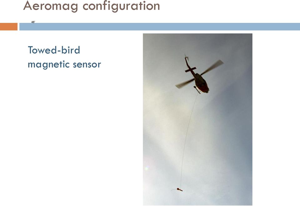
4 Elements of the platform Towed-bird configuration: far off the electromagnetic disturbances INGV

5 Aeromag configuration Towed-bird magnetic sensor
6 Tectono-dynamic triad WB-WARS-TAM (modified by Chiappini et al., Tectonophysics, 2002)

7 - Magnetic data: 2006 survey (CSIC-INGV UBU) Flight lines measured with an helicopter-borne Cs-vapor magnetometer owned by the INGV High-resolution magnetic anomaly map of Tenerife

8 - Inversion of the magnetic anomalies: linear method OBJECTIVE: To identify the main lateral magnetization contacts and to relate them with the magmatic feeding system.


9 SOUTHERN TYRRHENIAN SEA - GEODYNAMIC SETTING Heat flow and earthquakes


10 OBSERVATION The magnetic anomaly field of the VLS ridge can be described by four main regions, East-West oriented and alternating negative and positive signature on the North-South direction. The focus of the research is to obtain the magnetic bottom using the spectral method

11 time succession of overlapping and contiguous volcanic phases inner volcanic structure characterized by an omogenity of the magnetizzation properties due to the mafic nature of the first eruptive phases not magnetic basement with a graben like structure in which the VLS volcanism emplaced the regional local magnetic bottom is represented by the boundary between the volcanic units and the Arco Calabro basement. Below this depth, magnetized material can be found cristallized along the conduits or as intrusion in the fault pattern highly magnetized volcanics end in eteropy or interdigitized with the sedimets with null or very low magnetization. the highly magnetized sources are mainly lava blankets and vertical structures with deep roots (eg. dykes, cristallized vertical conduits); outcropping and shallower structures have low magnetization. This can be reasonably explained by: i. acid chemism; ii. demagnetization processes as hydrothermal activity (eg. Rivi and Fossa delle Felci). The magnetic sygnal derives from the island inner structure and it is not due to its topographic effect. direct structural control on the emplacement of volcanic bodies, this is reflected by the shape and orientation of the magnetic anomalies negative long wavelenghts mangetic anomalies are expression of the not magnetic sedimetary basins

 different magnetic pattern in the western and eastern sides pyroclastic and hyalocalstic")
 the VL double peaks are well matched by the field of a higly magnetic lava blanket with two deep conduits,")
12 CONVERGENCE BETWEEN MAGNETIC MODEL AND GEOLECTRICAL TOMOGRAPHY E-W PROFILE LA FOSSA CONE GNV PROJECT Sub Project V3_5 - VULCANO Istituto di Metodologie per l Analisi Ambientale CNR Tito Scalo (Pz) different magnetic pattern in the western and eastern sides pyroclastic and hyalocalstic units idrotermally altered with low to null magnetization (ANOMALY LF and VP); higly magnetized thickness of mafic lavas below the pyroclastic units of the La Fossa Cone (ANOMALY FC) the VL double peaks are well matched by the field of a higly magnetic lava blanket with two deep conduits, expression of mafic phase
 the VL double peaks are well matched by the field of a higly magnetic lava blanket with two deep conduits,")
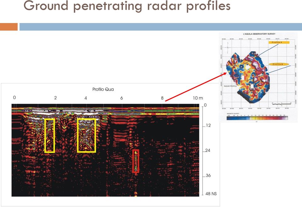
13 Further geophysical investigations Electrical resistivity (conductivity) measurements Ground penetrating radar

14 Geoelectrical measurements along profile A Magnetic profile

15 Geoelectrical measurements along profile B Magnetic profile

16 Ground penetrating radar profiles
17 Gravity surveys Scientists measure the gravitational acceleration, g, using gravity meters. The measurements are not affected by metallic bodies nearby as magnetic measurements.

18 Synergy among techniques: deliverables Ground-based, airborne, and satellite (InSAR) techniques act in an integrated manner to image and characterize areas in a very efficient manner from the surface with depth resolution. Output from module #1 will be input to module #2, contributing to define several parameters (e.g. construction, insurance, etc.)

CO 2 storage science development and application in Italy
 CO 2 storage science development and application in Italy Salvatore Lombardi Carbon Sequestration Leadership Forum, 16-19 April 2013 Rome, Italy Objectives Site selection and characterization Acquisition
Geothermal resources. Grado-1 borehole Future plans. Dep. of Civil and Environmental Engineering University of Trieste
 VII FIST - GEOITALIA Rimini 9-11 Settembre 2009 Geothermal potential of the carbonatic platform buried beneath the Veneto and Friuli coastal areas: results from the Grado-1 Borehole Geothermal resources
Mapping the Tyrrhenian and Adriatic Mohos across the northern and central Apennine chain through teleseismic receiver functions
 Mapping the Tyrrhenian and Adriatic Mohos across the northern and central Apennine chain through teleseismic receiver functions Giuliana Mele Istituto Nazionale di Geofisica e Vulcanologia - Roma, Italy
Chapter Overview. Bathymetry. Measuring Bathymetry. Echo Sounding Record. Measuring Bathymetry. CHAPTER 3 Marine Provinces
 Chapter Overview CHAPTER 3 Marine Provinces The study of bathymetry charts ocean depths and ocean floor topography. Echo sounding and satellites are efficient bathymetric tools. Most ocean floor features
Hydrothermal System After the 1990-95 Eruption Near the Lava Dome of Unzen Volcano, Japan
 Proceedings orld Geothermal Congress 25 Antalya, Turkey, 24-29 April 25 Hydrothermal System After the 199-95 ruption Near the Lava Dome of Unzen Volcano, Japan Yasuhiro Fujimitsu 1, Ryohei Kanou 2, Jun
Transform Boundaries
 Lecture 7 Plates and Mantle Plumes Transform Boundaries Transform boundaries occur where one segment of rigid lithosphere slides horizontally past another in response to stresses in the lithosphere. The
PERD/CCTII Workshop Offshore Beaufort Sea Development
 PERD/CCTII Workshop Offshore Beaufort Sea Development Snow and Ice Properties and Coastal Ice Morphology Of the McKenzie Delta with helicopter-borne Sensors Simon Prinsenberg and Ingrid Peterson BIO Scott
Ground Penetrating Radar Survey of a Portion of the Riverside Cemetery, Hopkinsville, Kentucky
 Ground Penetrating Radar Survey of a Portion of the Riverside Cemetery, Hopkinsville, Kentucky October 2012 Report prepared by Anthony L. Ortmann, Ph.D. Assistant Professor Department of Geosciences Murray
Integration between spaceand ground-based data sets: application on ground deformations measurements
 Integration between spaceand ground-based data sets: application on ground deformations measurements Giuseppe Puglisi Istituto Nazionale di Geofisica e Vulcanologia Sezione di Catania Osservatorio Etneo
Step 2: Learn where the nearest divergent boundaries are located.
 What happens when plates diverge? Plates spread apart, or diverge, from each other at divergent boundaries. At these boundaries new ocean crust is added to the Earth s surface and ocean basins are created.
TECTONICS ASSESSMENT
 Tectonics Assessment / 1 TECTONICS ASSESSMENT 1. Movement along plate boundaries produces A. tides. B. fronts. C. hurricanes. D. earthquakes. 2. Which of the following is TRUE about the movement of continents?
Overview of Submarine Cable Route Planning & Cable Route Survey Activities. Graham Evans Director EGS Survey Group www.egssurvey.
 Overview of Submarine Cable Route Planning & Cable Route Survey Activities Graham Evans Director EGS Survey Group www.egssurvey.com Presentation Summary Submarine cable systems concept to reality Objectives
ERMES. Monitoring of radon in geogas at the Gran Sasso National Laboratory
 ERMES. Monitoring of radon in geogas at the Gran Sasso National Laboratory G. De Luca a and W. Plastino b a Istituto Nazionale di Geofisica e Vulcanologia (INGV) Centro Nazionale Terremoti (CNT), Via di
Matt Harris, Golder Associates (NZ) Ltd. The value of geophysics as a non-intrusive method for site characterisation
 Ltd. The value of geophysics as a non-intrusive method for site characterisation") Matt Harris, Golder Associates (NZ) Ltd. The value of geophysics as a non-intrusive method for site characterisation Presentation Outline What is geophysics and how can it help me? Electrical Resistivity
Matt Harris, Golder Associates (NZ) Ltd. The value of geophysics as a non-intrusive method for site characterisation Presentation Outline What is geophysics and how can it help me? Electrical Resistivity
PALEOENVIRONMENTS OF THE LAKE BALATON AREA
 Eötvös Loránd University Department of Geophysics HUNGARY 1117 Budapest Pázmány Péter sétány 1/C Tel: +36-1-3812191 Fax: +36-1-3812192 E-mail: geofizika@ludens.elte.hu PALEOENVIRONMENTS OF THE LAKE BALATON
How Did These Ocean Features and Continental Margins Form?
 298 10.14 INVESTIGATION How Did These Ocean Features and Continental Margins Form? The terrain below contains various features on the seafloor, as well as parts of three continents. Some general observations
For personal use only
 DataMotion Asia Pacific Limited ABN 44 009 148 529 registered office Suite 3 72 Canning Hwy Vic Park WA 6100 AUSTRALIA mailing address Suite 6 72 Canning Hwy Vic Park WA 6100 AUSTRALIA telephone - national
Hot Spots & Plate Tectonics
 Hot Spots & Plate Tectonics Activity I: Hawaiian Islands Procedures: Use the map and the following information to determine the rate of motion of the Pacific Plate over the Hawaiian hot spot. The volcano
FROM DRAWING ANTICLINE AXES TO 3D MODELLING OF SEISMOGENIC SOURCES: EVOLUTION OF SEISMOTECTONIC MAPPING IN THE PO PLAIN
 FROM DRAWING ANTICLINE AXES TO 3D MODELLING OF SEISMOGENIC SOURCES: EVOLUTION OF SEISMOTECTONIC MAPPING IN THE PO PLAIN Burrato P.*, Maesano F. E. *, D Ambrogi C.**, Toscani G., Valensise G.* (*) INGV,
Regents Questions: Plate Tectonics
 Earth Science Regents Questions: Plate Tectonics Name: Date: Period: August 2013 Due Date: 17 Compared to the oceanic crust, the continental crust is (1) less dense and more basaltic (3) more dense and
Tsunami Practice Questions and Answers Revised November 2008
 Tsunami Practice Questions and Answers Revised November 2008 1. What happened on 26 December 2004 off the west coast of Sumatra? 2. What is the final estimate of the magnitude of the Sumatra 26 December
How can we make the most of magnetic data in building regional geological models?
 How can we make the most of magnetic data in building regional geological models? Clive Foss, Tony Meixner (Geoscience Australia) and James Austin MINERALS DOWN UNDER FLAGSHIP Excellent national magnetic
DYNAMIC CRUST: Unit 4 Exam Plate Tectonics and Earthquakes
 DYNAMIC CRUST: Unit 4 Exam Plate Tectonics and Earthquakes NAME: BLOCK: DATE: 1. Base your answer to the following question on The block diagram below shows the boundary between two tectonic plates. Which
The April 2007 eruption at Piton de la Fournaise, Réunion Island, imaged with ENVISAT-ASAR and ALOS-PALSAR data
 The April 27 eruption at Piton de la Fournaise, Réunion Island, imaged with ENVISAT-ASAR and A-PALSAR data A. Augier (1), J. L. Froger (1), V. Cayol (1) (1) Laboratoire Magmas et Volcans, Clermont Ferrand
Robot Perception Continued
 Robot Perception Continued 1 Visual Perception Visual Odometry Reconstruction Recognition CS 685 11 Range Sensing strategies Active range sensors Ultrasound Laser range sensor Slides adopted from Siegwart
Fugro monitoring services. If you can t measure it, you can t improve it : Lord Kelvin (1824-1907)
") Fugro monitoring services If you can t measure it, you can t improve it : Lord Kelvin (1824-1907) Local presence and global integration Fugro N.V. Onshore Geotechnics Ralf Trapphoff Onshore Geotechnics
Fugro monitoring services If you can t measure it, you can t improve it : Lord Kelvin (1824-1907) Local presence and global integration Fugro N.V. Onshore Geotechnics Ralf Trapphoff Onshore Geotechnics
MOHO DEPTH AND CRUSTAL STRUCTURE IN PENINSULAR ITALY
 MOHO DEPTH AND CRUSTAL STRUCTURE IN PENINSULAR ITALY Neutrino Geoscience 2010 Alessandro Amato Istituto Nazionale di Geofisica e Vulcanologia Talk outline Italy: tectonic setting and deep structures Moho
Earthquakes and Plate Boundaries Deborah Jordan and Samuel Spiegel
 Earthquakes and Plate Boundaries Deborah Jordan and Samuel Spiegel Jordan, Deborah and Spiegel, Samuel: Learning Research Development Center, University of Pittsburgh. Earthquakes and Plate Boundaries.
Continental Drift. Alfred Wegener (1880-1930) Proposed that all of the continents were once part of a large supercontinent - Pangaea Based on:
 Proposed that all of the continents were once part of a large supercontinent - Pangaea Based on:") Plate Tectonics and Continental Drift Continental Drift Alfred Wegener (1880-1930) Proposed that all of the continents were once part of a large supercontinent - Pangaea Based on: Similarities in shorelines
Plate Tectonics and Continental Drift Continental Drift Alfred Wegener (1880-1930) Proposed that all of the continents were once part of a large supercontinent - Pangaea Based on: Similarities in shorelines
Building 1D reference velocity model of the Irpinia region (Southern Apennines): microearthquakes locations and focal mechanism
: microearthquakes locations and focal mechanism") Building 1D reference velocity model of the Irpinia region (Southern Apennines): microearthquakes locations and focal mechanism Tutor Prof. Raffaella De Matteis PhD student Emanuela Matrullo Geophisics
Building 1D reference velocity model of the Irpinia region (Southern Apennines): microearthquakes locations and focal mechanism Tutor Prof. Raffaella De Matteis PhD student Emanuela Matrullo Geophisics
Chapter Contents Page No
 Chapter Contents Page No Preface Acknowledgement 1 Basics of Remote Sensing 1 1.1. Introduction 1 1.2. Definition of Remote Sensing 1 1.3. Principles of Remote Sensing 1 1.4. Various Stages in Remote Sensing
Nearly real-time monitoring system of TABOO seismic network activity.
 Nearly real-time monitoring system of TABOO seismic network activity. Marzorati S.* and TABOO working group * National Earthquake Centre, Ancona Istituto Nazionale di Geofisica e Vulcanologia Nearly real-time
Laboratory scale electrical resistivity measurements to monitor the heat propagation within porous media for low enthalpy geothermal applications
 32 CONVEGNO NAZIONALE 19-21 Novembre 2013 TRIESTE Laboratory scale electrical resistivity measurements to monitor the heat propagation within porous media for low enthalpy geothermal applications N. Giordano
Georgia Performance Standards Framework for Science Grade 6. Unit Organizer: Geology: Inside the Earth (Approximate Time: 7 Weeks)
") The following instructional plan is part of a GaDOE collection of Unit Frameworks, Performance Tasks, examples of Student Work, and Teacher Commentary. Many more GaDOE approved instructional plans are
The following instructional plan is part of a GaDOE collection of Unit Frameworks, Performance Tasks, examples of Student Work, and Teacher Commentary. Many more GaDOE approved instructional plans are
GTK Geophysics. Deep electromagnetic sounding, Western Greenland, 2013
 GTK Geophysics Deep electromagnetic sounding, Western Greenland, 2013 Heikki Vanhala, 2014 Geophysicists in GTK Rovaniemi kokkola Northern Finland Office Kuopio & KP Espoo Academic degree: M.Sc. 25 Dr.
COAL, OIL SHALE, NATURAL BITUMEN, HEAVY OIL AND PEAT Vol. I - Coal Exploration and Mining - Lixun Kang
 COAL EXPLORATION AND MINING Lixun Kang College of Mining Engineering, Taiyuan University of Technology, China Keywords: Surface Geophysics, Drilling, Surface Mining, Underground Mining, Coal Exploration,
In a majority of ice-crystal icing engine events, convective weather occurs in a very warm, moist, tropical-like environment. aero quarterly qtr_01 10
 In a majority of ice-crystal icing engine events, convective weather occurs in a very warm, moist, tropical-like environment. 22 avoiding convective Weather linked to Ice-crystal Icing engine events understanding
Plate Tectonics: Ridges, Transform Faults and Subduction Zones
 Plate Tectonics: Ridges, Transform Faults and Subduction Zones Goals of this exercise: 1. review the major physiographic features of the ocean basins 2. investigate the creation of oceanic crust at mid-ocean
RESULTS FROM A SIMPLE INFRARED CLOUD DETECTOR
 RESULTS FROM A SIMPLE INFRARED CLOUD DETECTOR A. Maghrabi 1 and R. Clay 2 1 Institute of Astronomical and Geophysical Research, King Abdulaziz City For Science and Technology, P.O. Box 6086 Riyadh 11442,
Rocks and Plate Tectonics
 Name: Class: _ Date: _ Rocks and Plate Tectonics Multiple Choice Identify the choice that best completes the statement or answers the question. 1. What is a naturally occurring, solid mass of mineral or
CHAPTER 6 THE TERRESTRIAL PLANETS
 CHAPTER 6 THE TERRESTRIAL PLANETS MULTIPLE CHOICE 1. Which of the following is NOT one of the four stages in the development of a terrestrial planet? 2. That Earth, evidence that Earth differentiated.
POTENTIAL AND LIMITATIONS OF THE ARCHAEO-GEOPHYSICAL TECHNIQUES
 Geoarchaeology and Archaeomineralogy (Eds. R. I. Kostov, B. Gaydarska, M. Gurova). 2008. Proceedings of the International Conference, 29-30 October 2008 Sofia, Publishing House St. Ivan Rilski, Sofia,
A remote sensing instrument collects information about an object or phenomenon within the
 Satellite Remote Sensing GE 4150- Natural Hazards Some slides taken from Ann Maclean: Introduction to Digital Image Processing Remote Sensing the art, science, and technology of obtaining reliable information
Overlapping rifts in southern Iceland QUEST field trips: 15 and 17 July 2011 Freysteinn Sigmundsson (fs@hi.is)
") Overlapping rifts in southern Iceland QUEST field trips: 15 and 17 July 2011 Freysteinn Sigmundsson (fs@hi.is) The geological map of Iceland gives an excellent overview. The plate boundary is broken up
Overlapping rifts in southern Iceland QUEST field trips: 15 and 17 July 2011 Freysteinn Sigmundsson (fs@hi.is) The geological map of Iceland gives an excellent overview. The plate boundary is broken up
Interpretation of gravity and aeromagnetic anomalies of the Konya Region, South Central Turkey
 JOURNAL OF THE BALKAN GEOPHYSICAL SOCIETY, Vol. 3, No 3, August 2000, p. 37-44, 13 figs. Interpretation of gravity and aeromagnetic anomalies of the Konya Region, South Central Turkey A. Ates 1,* and P.
Volcanoes Erupt Grade 6
 TEACHING LEARNING COLLABORATIVE (TLC) EARTH SCIENCE Volcanoes Erupt Grade 6 Created by: Debra McKey (Mountain Vista Middle School); Valerie Duncan (Upper Lake Middle School); and Lynn Chick (Coyote Valley
Passive Remote Sensing of Clouds from Airborne Platforms
 Passive Remote Sensing of Clouds from Airborne Platforms Why airborne measurements? My instrument: the Solar Spectral Flux Radiometer (SSFR) Some spectrometry/radiometry basics How can we infer cloud properties
Georgia Performance Standards Framework for Shaky Ground 6 th Grade
 The following instructional plan is part of a GaDOE collection of Unit Frameworks, Performance Tasks, examples of Student Work, and Teacher Commentary. Many more GaDOE approved instructional plans are
6.E.2.2 Plate Tectonics, Earthquakes and Volcanoes
 Name: Date: 1. The road shown below was suddenly broken by a natural event. 3. The convergence of two continental plates would produce Which natural event most likely caused the crack in the road? island
Project V3 Lava PROJECT V3 LAVA
 Project V3 Lava PROJECT V3 LAVA 177 178 Project V3 Lava Coordinators: Project V3 - LAVA Realization of the lava flow hazard map at Mount Etna and set up of a method for its dynamic update Ciro Del Negro,
Plate Tectonics Lab. Continental Drift. The Birth of Plate Tectonics
 Plate Tectonics Lab Continental Drift Take a look at a globe sometime and observe the remarkable fit between South America and Africa. Could they have, in fact, been connected? During the 19th and early
PHYS 222 Spring 2012 Final Exam. Closed books, notes, etc. No electronic device except a calculator.
 PHYS 222 Spring 2012 Final Exam Closed books, notes, etc. No electronic device except a calculator. NAME: (all questions with equal weight) 1. If the distance between two point charges is tripled, the
Review for Introduction to Remote Sensing: Science Concepts and Technology
 Review for Introduction to Remote Sensing: Science Concepts and Technology Ann Johnson Associate Director ann@baremt.com Funded by National Science Foundation Advanced Technological Education program [DUE
Western Australia - A1 Gold and The Walhalla Project
 ANNUAL REPORT 2015 Contents Key Points 1 Chairman s Report 2 Review Of Operations 3 Directors Report 15 Auditor s Independence Declaration 32 Consolidated Statement of Profit or Loss 33 Consolidated Statement
Continental Drift, Sea Floor Spreading and Plate Tectonics
 Page 1 of 13 EENS 1110 Tulane University Physical Geology Prof. Stephen A. Nelson Continental Drift, Sea Floor Spreading and Plate Tectonics This page last updated on 26-Aug-2015 Plate Tectonics is a theory
How To Explore A Hot Spring
 Exploration Techniques The Geothermal Institute University of Auckland Bridget Lynne Santiago de Chile, 26-29 May 2014 Exploration Techniques Bridget Y. Lynne New techniques in geothermal exploration NZ
Moultrie Group Subsurface Geophysical Surveys
 Moultrie Group Subsurface Geophysical Surveys Martin Brook Moultrie Geology, Banyo, Brisbane, QLD 04 37887 362 mbrook@moultrie.com.au Subsurface Geophysical Surveys Martin Brook / Senior Project Geologist
Plate Tectonics Chapter 2
 Plate Tectonics Chapter 2 Does not include complete lecture notes. Continental drift: An idea before its time Alfred Wegener First proposed his continental drift hypothesis in 1915 Published The Origin
For personal use only
 ASX ANNOUNCEMENT 7 MARCH 2012 Phoenix Copper Limited ABN 67 127 446 271 Level 1, 135 Fullarton Road Rose Park, SA 5067 Australia Telephone +61 (0)8 8364 3188 Facsimile +61 (0)8 8364 4288 info@phoenixcopper.com.au
Groundwater exploration WATEX applications with Ground Penetrating Radars. Dr.Saud Amer USGS Dr.Alain Gachet Radar Technologies France
 Groundwater exploration WATEX applications with Ground Penetrating Radars Dr.Saud Amer USGS Dr.Alain Gachet Radar Technologies France GPR is a technology that allows rapid and non destructive collection
Soil degradation monitoring by active and passive remote-sensing means: examples with two degradation processes
 Soil degradation monitoring by active and passive remote-sensing means: examples with two degradation processes Naftaly Goldshleger, *Eyal Ben-Dor,* *Ido Livne,* U. Basson***, and R.Ben-Binyamin*Vladimir
The CO2 Geological Storage: how it works Salvatore Lombardi
 The CO2 Geological Storage: how it works Salvatore Lombardi Carbonia, Centro Ricerche Sotacarbo, 27 novembre 2014 Contents of the presentation Notes on CO2 Geological Storage (CGS) How it works How we
Francisco Edson M. Gomes Geologist CPRM Geological Survey of Brazil
 Francisco Edson M. Gomes Geologist CPRM Geological Survey of Brazil Area BACKGROUND The Atlas of the South Atlantic Ocean Data organized in GIS was designed by the Geological Survey of Brazil (CPRM) and
1. The diagram below shows a cross section of sedimentary rock layers.
 1. The diagram below shows a cross section of sedimentary rock layers. Which statement about the deposition of the sediments best explains why these layers have the curved shape shown? 1) Sediments were
Google Explores the 10 th Planet
 Google Explores the 10 th Planet Mermaids and Sea Serpents NASA has spent tens of billions of dollars exploring Planet Earth and the other 8 planets of our solar system yet there is one last great frontier
Operations in the Arctic areas? New challenges: Exploration Development Production
 Operations in the Arctic areas? New challenges: Exploration Development Production The oil and gas cycle Life cycle of oil and gas (time) 1) 2) 3) 4) 5) 6) Activity In-house study and get licenses: Find
How To Monitor Sea Level With Satellite Radar
 Satellite Altimetry Wolfgang Bosch Deutsches Geodätisches Forschungsinstitut (DGFI), München email: bosch@dgfi.badw.de Objectives You shall recognize satellite altimetry as an operational remote sensing
Development of Tunnel Electrical Resistivity Prospecting System and its Applicaton
 Development of Tunnel Electrical Resistivity Prospecting System and its Applicaton HEE-HWAN RYU 1, GYE-CHUN CHO 2, SUNG-DON YANG 3 and HYUN-KANG SHIN 4 1 Professor, Korea Advanced Institute of Science
Hakim Saibi 1, Jun Nishijima 2, Sachio Ehara 2, Yasuhiro Fujimitsu 2 and Koichiro Fukuoka 2
 PROCEEDINGS, Thirtieth Workshop on Geothermal Reservoir Engineering Stanford University, Stanford, California, January 31-February 2, 2 SGP-TR-176 DETERMINATION OF SHALLOW GROUNDWATER LEVEL CHANGE USING
hs2 Ground A non-technical guide
 hs2 Ground Investigations A non-technical guide Contents HS2 ground investigations 1 Essential Q&A 2 2 In-ground investigation techniques 9 2.1 Cable percussion borehole 10 2.2 Rotary core borehole 12
Plate Tectonics Practice Questions and Answers Revised August 2007
 Plate Tectonics Practice Questions and Answers Revised August 2007 1. Please fill in the missing labels. 2. Please fill in the missing labels. 3. How many large plates form the outer shell of the earth?
Active and Passive Microwave Remote Sensing
 Active and Passive Microwave Remote Sensing Passive remote sensing system record EMR that was reflected (e.g., blue, green, red, and near IR) or emitted (e.g., thermal IR) from the surface of the Earth.
Crossing the Pacific Bathymetry
 Crossing the Pacific Bathymetry Summary What is really under the salt water in our worldwide oceans? This four-part activity will guide students to explore, investigate, and analyze our mysterious ocean
International Gravity Field Service (IGFS)
") IAG Services: International Gravity Field Service (IGFS) 1 International Gravity Field Service (IGFS) http://www.gravityfield.org Chairman: Renè Forsberg (Denmark, 2011-2013) - Riccardo Barzaghi (Italy,
IAG Services: International Gravity Field Service (IGFS) 1 International Gravity Field Service (IGFS) http://www.gravityfield.org Chairman: Renè Forsberg (Denmark, 2011-2013) - Riccardo Barzaghi (Italy,
Radar Interferometric and Polarimetric Possibilities for Determining Sea Ice Thickness
 Radar Interferometric and Polarimetric Possibilities for Determining Sea Ice Thickness by Scott Hensley, Ben Holt, Sermsak Jaruwatanadilok, Jeff Steward, Shadi Oveisgharan Delwyn Moller, Jim Reis, Andy
11. NONDESTRUCTIVE TESTING
 11. NONDESTRUCTIVE TESTING Nondestructive testing includes magnetic particle testing (MT), Liquid Dye Penetrant testing (PT), Radiographic Testing (RT) and Ultrasonic Testing (UT). The purpose of nondestructive
Publications in journals
 Publications in journals Capuano, P., Russo, G., and Scarpa, R., 2013, P-wave velocity and density structure beneath Mt. Vesuvius: a magma body in the upper edifice?: Ann. Geophys., 56, 1-13, doi: 10.4401/ag-6443
On-Site Inspection BY ZHENFU LI
 On-Site Inspection BY ZHENFU LI O N - S I T E I N S P E C T I O N On-Site Inspection BY ZHENFU LI FACT BOX An on-site inspection (OSI) can involve a number of geophysical techniques. Noble gases such as
HAZARD MAPPING, RISK ASSESSMENT, AND INSURANCE COVERAGE OF NATURAL CATASTROPHE RISK
 SESSION III HAZARD MAPPING, RISK ASSESSMENT, AND INSURANCE COVERAGE OF NATURAL CATASTROPHE RISK Mr. Sumarjono Insurance Bureau of The Ministry of Finance of the Republic of Indonesia Geological Position
View. A New. Into Earth
 View A New Into Earth EarthScope is a bold undertaking to apply modern observational, analytical and telecommunications technologies to investigate the structure and evolution of the North American continent
Europa and Titan: Oceans in the Outer Solar System? Walter S. Kiefer, Lunar and Planetary Institute, Houston TX
 Europa and Titan: Oceans in the Outer Solar System? Walter S. Kiefer, Lunar and Planetary Institute, Houston TX Biologists believe that life requires the presence of some sort of liquid to serve as a medium
The CO2 Geological Storage: how it works
 The CO2 Geological Storage: how it works Salvatore Lombardi Carbonia, Centro Ricerche Sotacarbo, 27 novembre 2014 Contents of the presentation Notes on CO2 Geological Storage (CGS) How it works How we
ENVI Classic Tutorial: Atmospherically Correcting Hyperspectral Data using FLAASH 2
 ENVI Classic Tutorial: Atmospherically Correcting Hyperspectral Data Using FLAASH Atmospherically Correcting Hyperspectral Data using FLAASH 2 Files Used in This Tutorial 2 Opening the Uncorrected AVIRIS
Dawn - Overview, Science Objectives, Mission Progress. Hap McSween For PI Chris Russell
 Dawn - Overview, Science Objectives, Mission Progress Hap McSween For PI Chris Russell Presentation to Decadal Survey Primitive Bodies Panel, Washington, DC, Sep 2009 Spacecraft configuration, assembly
Plate Tectonics. Introduction. Boundaries between crustal plates
 Plate Tectonics KEY WORDS: continental drift, seafloor spreading, plate tectonics, mid ocean ridge (MOR) system, spreading center, rise, divergent plate boundary, subduction zone, convergent plate boundary,
II. Earth Science (Geology) Section (9/18/2013)
 Section (9/18/2013)") EAPS 100 Planet Earth Lecture Topics Brief Outlines II. Earth Science (Geology) Section (9/18/2013) 1. Interior of the Earth Learning objectives: Understand the structure of the Earth s interior crust,
EAPS 100 Planet Earth Lecture Topics Brief Outlines II. Earth Science (Geology) Section (9/18/2013) 1. Interior of the Earth Learning objectives: Understand the structure of the Earth s interior crust,
Earth Egg Model Teacher Notes
 Ancient Greeks tried to explain earthquakes and volcanic activity by saying that a massive bull lay underground and the land shook when it became angry. Modern theories rely on an understanding of what
STRENGTHS AND WEAKNESSES OF GRAVITY AND MAGNETICS AS EXPLORATION TOOLS FOR GEOTHERMAL ENERGY
 Presented at Short Course V on Exploration for Geothermal Resources, organized by UNU-GTP, GDC and KenGen, at Lake Bogoria and Lake Naivasha, Kenya, Oct. 29 Nov. 19, 2010. GEOTHERMAL TRAINING PROGRAMME
Map Patterns and Finding the Strike and Dip from a Mapped Outcrop of a Planar Surface
 Map Patterns and Finding the Strike and Dip from a Mapped Outcrop of a Planar Surface Topographic maps represent the complex curves of earth s surface with contour lines that represent the intersection
INDIRECT METHODS SOUNDING OR PENETRATION TESTS. Dr. K. M. Kouzer, Associate Professor in Civil Engineering, GEC Kozhikode
 INDIRECT METHODS SOUNDING OR PENETRATION TESTS STANDARD PENETRATION TEST (SPT) Reference can be made to IS 2131 1981 for details on SPT. It is a field edtest to estimate e the penetration e resistance
Interactive Plate Tectonics
 Interactive Plate Tectonics Directions: Go to the following website and complete the questions below. http://www.learner.org/interactives/dynamicearth/index.html How do scientists learn about the interior
Applications of Integrated Vessel-based LiDAR, Multibeam Bathymetry, and Geophysical Surveys for Geohazard Assessments and Site Characterization
 Applications of Integrated Vessel-based LiDAR, Multibeam Bathymetry, and Geophysical Surveys for Geohazard Assessments and Site Characterization James Fisher Engineering Geologist Todd Mitchell Survey
Scientific Progress and Recommendations from the International Volcanic Ash Task Force
 Scientific Progress and Recommendations from the International Volcanic Ash Task Force Marianne Guffanti, USGS Larry Mastin, USGS Andrew Tupper, Australian Bureau of Meteorology Raul Romero, ICAO Peter
Plate Tectonics Short Study Guide
 Name: Class: Date: Plate Tectonics Short Study Guide Multiple Choice Identify the letter of the choice that best completes the statement or answers the question. 1. The existence of coal beds in Antarctica
Chapter 8: Plate Tectonics -- Multi-format Test
 Name: Class: Date: ID: A Chapter 8: Plate Tectonics -- Multi-format Test Modified True/False Indicate whether the statement is true or false. If false, change the identified word or phrase to make the
Geospatial Information for disaster risk reduction and natural resources management. Rolando Ocampo Alcántar
 Geospatial Information for disaster risk reduction and natural resources management Rolando Ocampo Alcántar Content Background Geospatial Information for Disaster Management Risk Atlas Information Exchange
Plate Tectonics. Plate Tectonics The unifying concept of the Earth sciences. Continental Drift
 Plate Tectonics The unifying concept of the Earth sciences. The outer portion of the Earth is made up of about 20 distinct plates (~ 100 km thick), which move relative to each other This motion is what
Tutorial case study D (GIS import)
") GeoModeller User Manual Tutorial case study D (GIS ) 1 Tutorial case study D (GIS ) 3D GeoModeller User Manual and Tutorials Author: Desmond Fitzgerald, Intrepid Geophysics Editor: Claire Edwards, Intrepid
GeoModeller User Manual Tutorial case study D (GIS ) 1 Tutorial case study D (GIS ) 3D GeoModeller User Manual and Tutorials Author: Desmond Fitzgerald, Intrepid Geophysics Editor: Claire Edwards, Intrepid
Figure 1: SITCRIM location. Thirteenth International Congress of the Brazilian Geophysical Society
 First Brazilian Federal Police Test Site for Forensic Geophysical Research BLUM, Marcelo de Lawrence Bassay, Departamento de Polícia Federal CAVALCANTI, Márcio Maciel, Universidade de Brasília RUSSO, Daniel,
Using Optech LMS to Calibrate Survey Data Without Ground Control Points
 Challenge An Optech client conducted an airborne lidar survey over a sparsely developed river valley. The data processors were finding that the data acquired in this survey was particularly difficult to