La tettonica attiva nelle Alpi e la rete transnazionale di stazioni permanenti GPS
|
|
|
- Adela Charles
- 8 years ago
- Views:
Transcription
1 La tettonica attiva nelle Alpi e la rete transnazionale di stazioni permanenti GPS Karim Aoudia Abdus Salam International Centre for theoretical Physics Earth System Physics Section

2 GPS monitoring - monumentation on rock - antenna forced centering with sub-millimetre repeatabiliy (ad hoc designed antenna mount, thoroidal level for vertical positioning) - spirit levelling on each site to check for local vertical stability

3 Block-like Motion

4 Block-like Motion
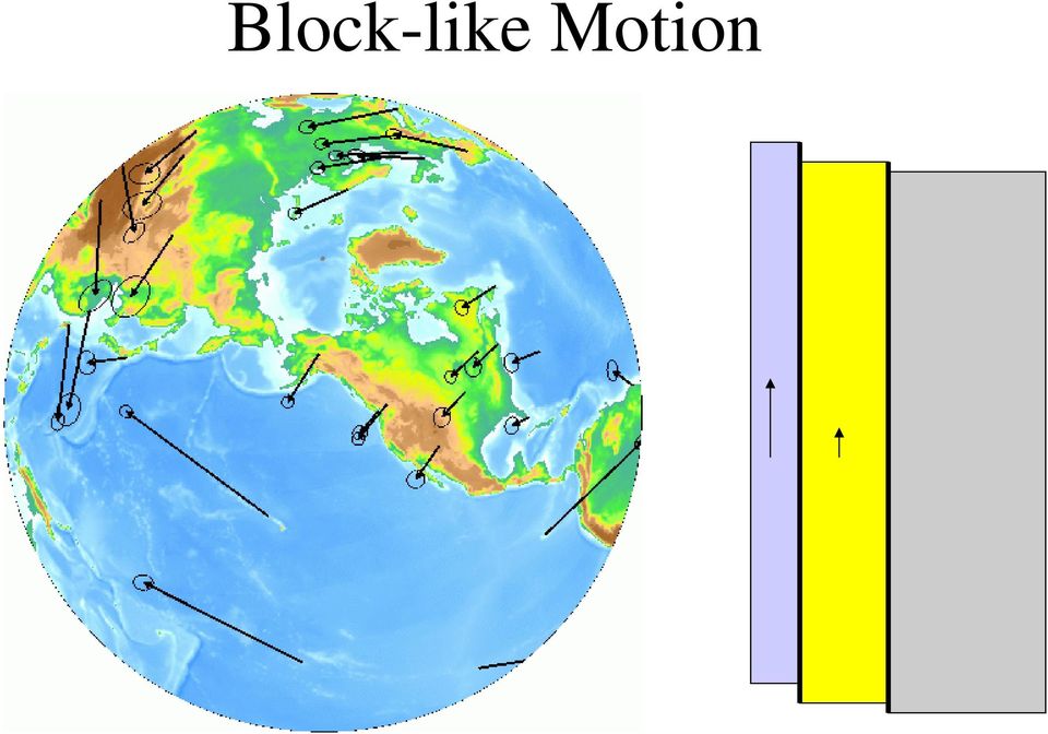
5 Block-like Motion

6 Block-like Motion

7 D
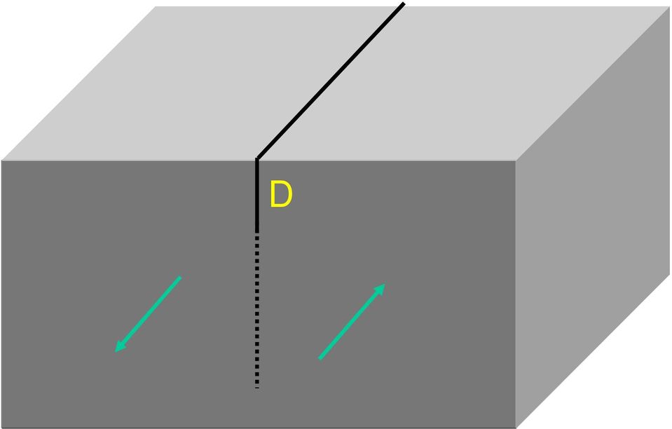
8 S

9 Cartoon showing how geologic block motions are represented as the sum of coseismic and interseismic deformation fields

10 Vernant et al. 2004

11 Due tipologie di modelli del ciclo sismico A. Quasi periodic earthquake occurrence (Shimazaki & Nakata s s model) B. Clustered earthquake occurrence (wallace s model)
 B.")
12 Motion before, during and after Earthquakes. Example from Hector Mine, CA 40 LDES Site Mojave Desert North Position (mm) Hector Mine Earthquake (166 mm removed) Year
 -10 1999 1999.")
13 Scala di Lunghezza del cosismico e del postsismico per un monitoraggio GPS 0 mm mm

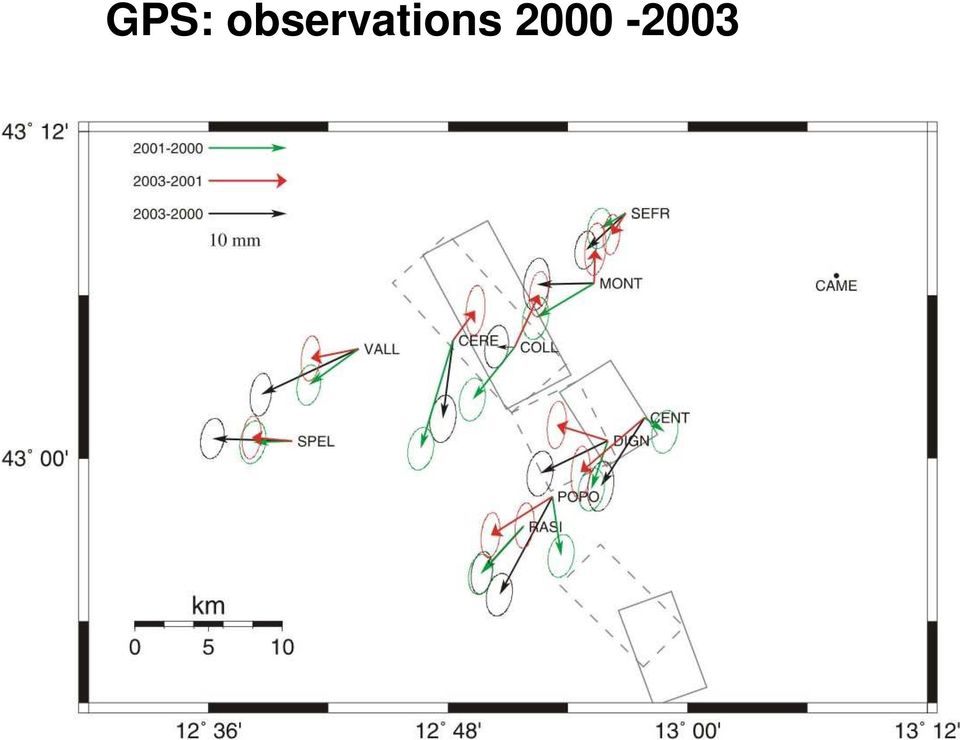
14 GPS: observations
15 GPS observations and viscoelastic relaxation for different fault models

16 a) visco-elastic relaxation, b) deep after-slip, c) up-dip shallow creep, d) summation ( )
")
17

18 Alpine Integrated GPS Network: Real-Time Monitoring and Master Model for Continental Deformation and Earthquake Hazard Una rete di stazioni GPS per il controllo geodinamico dell'area alpina TRIESTE FEBRUARY 26 and 27th Ziegler & Dezes, 2005

19 Alpine Integrated GPS Network: Real-Time Monitoring and Master Model for Continental Deformation and Earthquake Hazard Una rete di stazioni GPS per il controllo geodinamico dell'area alpina Glacier shrinkage and uplift of the Alps TRIESTE FEBRUARY 26 and 27th

20 Sismicita storica 1356 I 0 7. Data: Sirène ne,, ECOS and Grünthal (2003)

21 Basel, 1356 Menton,, 1887 Udine, 1511
22 Need to monitor crustal deformation at a wide range of spatio-temporal scales GAIN CGPS data will very likely revolutionize our understanding of the Alpine crustal deformation, including fault friction and the rheology of deformation
23 Alpine Integrated GPS Network: Real-Time Monitoring and Master Model for Continental Deformation and Earthquake Hazard Una rete di stazioni GPS per il controllo geodinamico dell'area alpina System Architecture Processing Centers Internet ftp Data Trieste Local GPS Network LAN smb Data and DQE TM output Data Data Receiving Server & DQE TM Partners GPS Receivers TRIESTE FEBRUARY 26 and 27th Data, DQE ranking Web site and forum Leading Partner Data Center Internet ftp Data Internet http Partners Data Centers
24 Alpine Integrated GPS Network: Real-Time Monitoring and Master Model for Continental Deformation and Earthquake Hazard Una rete di stazioni GPS per il controllo geodinamico dell'area alpina TRIESTE FEBRUARY 26 and 27th
25 Alpine Integrated GPS Network: Real-Time Monitoring and Master Model for Continental Deformation and Earthquake Hazard Una rete di stazioni GPS per il controllo geodinamico dell'area alpina Processing Results of the GAIN network: RMS *) [mm] North 1.4 East 1.4 Height Derived repeatability's are excellent. Applied models and processing strategies are successful. The RMS of the coordinate repeatability reveals easily stations with strange behaviour. 3.7 TRIESTE FEBRUARY 26 and 27th Coordinate changes of a few mm are already detectable! The cause for the change of position needs to be evaluated. *) Linear Velocity removed
26 Typical Time Series of Coordinate Changes
27 Alpine Integrated GPS Network: Real-Time Monitoring and Master Model for Continental Deformation and Earthquake Hazard Una rete di stazioni GPS per il controllo geodinamico dell'area alpina Velocities in the ITRF2000 (horizontal) TRIESTE FEBRUARY 26 and 27th
28 Alpine Integrated GPS Network: Real-Time Monitoring and Master Model for Continental Deformation and Earthquake Hazard Una rete di stazioni GPS per il controllo geodinamico dell'area alpina first evaluation of station velocities based on 6 years of data ( ) TRIESTE FEBRUARY 26 and 27th
Exploring plate motion and deformation in California with GPS
 Exploring plate motion and deformation in California with GPS Student worksheet Cate Fox-Lent, UNAVCO master teacher; Andy Newman, Georgia Institute of Technology; Shelley Olds, UNAVCO; and revised by
CORS/OPUS: Status & Future Prospects
 CORS/OPUS: Status & Future Prospects Richard Snay, Gerald Mader, & Neil Weston NOAA s National Geodetic Survey CORS Users Forum 44 th CGSIC Meeting Long Beach, CA September 21, 2004 Continuously Operating
improved understanding of secular and transient deformation in Southern California and loading of How can the CRM contribute to seismogenic faults?
 How can the CRM contribute to improved understanding of secular and transient deformation in Southern California and loading of seismogenic faults? Yuri Fialko Institute of Geophysics and Planetary Physics
Deformation Monitoring and Analysis Using Regional GPS Permanent Tracking Station Networks
 Deformation Monitoring and Analysis Using Regional GPS Permanent Tracking Station Networks Youjian HU, China P. R. and Kefei ZHANG and Gangjun LIU, Australia Key words: CORS, ITRF, precise ephemeris, deformation
Pacific Sea Level Monitoring Project
 Record 2015/04 GeoCat 82325 Pacific Sea Level Monitoring Project CGPS Coordinate Time Series Analysis Report Jia, M., Dawson, J., Twilley, B. and Hu, G. APPLYING GEOSCIENCE TO AUSTRALIA S MOST IMPORTANT
A New Map of UK Vertical Land Movements based on Continuous GPS and Absolute Gravity
 A New Map of UK Vertical Land Movements based on Continuous GPS and Absolute Gravity Dionne Hansen(Nottingham), Norman Teferle(Nottingham), Richard Bingley(Nottingham) And Simon Williams(POL) EGU2009,
Evolving a new Geodetic Positioning Framework: An Australian Perspective
 Evolving a new Geodetic Positioning Framework: An Australian Perspective G. Johnston, J. Dawson Outline Introduction Precise Positioning National Geospatial Reference Systems Asia Pacific Reference Frame
Earthquakes. Earthquakes: Big Ideas. Earthquakes
 Earthquakes Earthquakes: Big Ideas Humans cannot eliminate natural hazards but can engage in activities that reduce their impacts by identifying high-risk locations, improving construction methods, and
Integrated surveying system for landslide monitoring, Valoria Landslide (Appennines of Modena, Italy)
") Integrated surveying system for landslide monitoring, Valoria Landslide (Appennines of Modena, Italy) Eleonora BERTACCHINI, Andrea CAPITANI, Alessandro CAPRA, Cristina CASTAGNETTI, Alessandro CORSINI,
Integrated surveying system for landslide monitoring, Valoria Landslide (Appennines of Modena, Italy) Eleonora BERTACCHINI, Andrea CAPITANI, Alessandro CAPRA, Cristina CASTAGNETTI, Alessandro CORSINI,
RMS - Remote Monitoring System: GPS application on an Harbour Structure
 Ingenieurvermessung 2004 14th International Conference on Engineering Surveying Zürich, 15. 19. März 2004 RMS - Remote Monitoring System: GPS application on an Harbour Structure Luca Manetti GEODEV SA
CENTRO DI GEODESIA SPAZIALE MATERA. WIDE SURVEY OF THE MATERA SITE (August 98)
") CENTRO DI GEODESIA SPAZIALE MATERA WIDE SURVEY OF THE MATERA SITE (August 98) Doc. Nr.: 180.010-CSM-Errore. L'argomento parametro è sconosciuto. Date: 13/August/98 Function Name Date Signature Author D.
CENTRO DI GEODESIA SPAZIALE MATERA WIDE SURVEY OF THE MATERA SITE (August 98) Doc. Nr.: 180.010-CSM-Errore. L'argomento parametro è sconosciuto. Date: 13/August/98 Function Name Date Signature Author D.
COLOCATIONS AND MONUMENTATION IN THE DORIS NETWORK
 COLOCATIONS AND MONUMENTATION IN THE DORIS NETWORK Hervé FAGARD (Institut Géographique National - France) 1 H. Fagard (IGN-F) Antenna types in the DORIS permanent network Alcatel Starec 10 stations Deployed
INTEGRATED ANALYSIS OF THE ENVIRONMENTAL MONITORING MEASUREMENTS IN THE GEODYNAMIC TEST NETWORK SÓSKÚT
 PERIODICA POLYTECHNICA SER. CIV. ENG. VOL. 46, NO. 2, PP. 159 168 (2002) INTEGRATED ANALYSIS OF THE ENVIRONMENTAL MONITORING MEASUREMENTS IN THE GEODYNAMIC TEST NETWORK SÓSKÚT József ÁDÁM, László BÁNYAI,
FROM DRAWING ANTICLINE AXES TO 3D MODELLING OF SEISMOGENIC SOURCES: EVOLUTION OF SEISMOTECTONIC MAPPING IN THE PO PLAIN
 FROM DRAWING ANTICLINE AXES TO 3D MODELLING OF SEISMOGENIC SOURCES: EVOLUTION OF SEISMOTECTONIC MAPPING IN THE PO PLAIN Burrato P.*, Maesano F. E. *, D Ambrogi C.**, Toscani G., Valensise G.* (*) INGV,
Plate Tectonics: Ridges, Transform Faults and Subduction Zones
 Plate Tectonics: Ridges, Transform Faults and Subduction Zones Goals of this exercise: 1. review the major physiographic features of the ocean basins 2. investigate the creation of oceanic crust at mid-ocean
GPS Precise Point Positioning as a Method to Evaluate Global TanDEM-X Digital Elevation Model
 GPS Precise Point Positioning as a Method to Evaluate Global TanDEM-X Digital Elevation Model 7 th FIG Regional Conference TS 1C Advances in GNSS Positioning and Applications I Volker Schwieger 1, Jürgen
Local monitoring by low cost devices and free and open sources softwares
 Local monitoring by low cost devices and free and open sources softwares Abstract Ludovico Biagi, Florin-Catalin Grec, Marco Negretti, Maria Grazia Visconti Politecnico di Milano, DICA@ComoCampus The purpose
The Next Generation Science Standards (NGSS) Correlation to. EarthComm, Second Edition. Project-Based Space and Earth System Science
 Correlation to. EarthComm, Second Edition. Project-Based Space and Earth System Science") The Next Generation Science Standards (NGSS) Achieve, Inc. on behalf of the twenty-six states and partners that collaborated on the NGSS Copyright 2013 Achieve, Inc. All rights reserved. Correlation to,
The Next Generation Science Standards (NGSS) Achieve, Inc. on behalf of the twenty-six states and partners that collaborated on the NGSS Copyright 2013 Achieve, Inc. All rights reserved. Correlation to,
STRUCTURES. 1.1. Excavation and backfill for structures should conform to the topic EXCAVATION AND BACKFILL.
 STRUCTURES 1. General. Critical structures may impact the integrity of a flood control project in several manners such as the excavation for construction of the structure, the type of foundation, backfill
Reading GPS Time Series Plots Worksheet
 Reading GPS Time Series Plots Worksheet By: Roger Groom and Cate Fox-Lent, UNAVCO Master Teachers in-residence, Shelley Olds, UNAVCO The Global Positioning System, GPS, is used to study the Earth, how
Which Way are We Going? Online Mapping Tools to Help People Visualize Plate Motions with GPS Data. Shelley Olds, UNAVCO
 Which Way are We Going? Online Mapping Tools to Help People Visualize Plate Motions with GPS Data Shelley Olds, UNAVCO Tools to help people visualize science concepts Temporal & Spatial scales can be difficult
Chapter 5: Earthquakes
 Chapter 5: Earthquakes 1. Experiencing an Earthquake firsthand 2. The Science of Ghost Forests and Megaearthquakes 3. Faults, Earthquakes, and Plate Tectonics 4. Seismic Waves and Earthquake Detection
Plate Tectonics. Introduction. Boundaries between crustal plates
 Plate Tectonics KEY WORDS: continental drift, seafloor spreading, plate tectonics, mid ocean ridge (MOR) system, spreading center, rise, divergent plate boundary, subduction zone, convergent plate boundary,
Name: Date: Class: Finding Epicenters and Measuring Magnitudes Worksheet
 Example Answers Name: Date: Class: Finding Epicenters and Measuring Magnitudes Worksheet Objective: To use seismic data and an interactive simulation to triangulate the location and measure the magnitude
THE NEED TO IMPLEMENT CONSTRUCTION DEFORMATION SPATIAL MONITORING SYSTEMS IN ROMANIA
 THE NEED TO IMPLEMENT CONSTRUCTION DEFORMATION SPATIAL MONITORING SYSTEMS IN ROMANIA Cristian ONU, Lecturer PhD. Eng., Technical University Gheorghe Asachi of Iasi, Romania, e-mail: cristi_onu@yahoo.com
Chapter 34 Latest GNSS Results of the CMONOC Network and Its Application in Earthquake Monitoring
 Chapter 34 Latest GNSS Results of the CMONOC Network and Its Application in Earthquake Monitoring Junping Chen, Yize Zhang, Yibing Xie, Weijie Tan, Sainan Yang and Bin Wu Abstract Crustal Movement Observation
WHAT YOU NEED TO USE THE STATE PLANE COORDINATE SYSTEMS
 WHAT YOU NEED TO USE THE STATE PLANE COORDINATE SYSTEMS N & E State Plane Coordinates for Control Points AZIMUTHS - True, Geodetic, or Grid - Conversion from Astronomic to Geodetic (LaPlace Correction)
Data in seismology: networks, instruments, current problems
 Data in seismology: networks, instruments, current problems Seismic networks, data centres, instruments Seismic Observables and their interrelations Seismic data acquisition parameters (sampling rates,
Unità locale La Sapienza:
 Unità locale La Sapienza: Walter Lacarbonara Dipartimento di Ingegneria Strutturale e Geotecnica Kick-Off PRIN 2008 Shape memory alloy advanced modeling for industrial and biomedical applications Dipartimento
Development and application of an experimental data server hosting EGNOS and RTCM/RTK correction data for terrestrial navigation
 DIA DEPARTMENT OF ENGINEERING AND ARCHITECTURE UNIVERSITY OF TRIESTE ITALY Development and application of an experimental data server hosting EGNOS and RTCM/RTK correction data for terrestrial navigation
February 28 Earthquake: We got off easy
 February 28 Earthquake: We got off easy State Geologist John Beaulieu Lucky may not be the first word that comes to mind after an earthquake that injured more than 200 and caused more than $1 billion damage,
Online Precise Point Positioning Using the. Natural Resources Canada Canadian Spatial Reference System (CSRS-PPP)
") Online Precise Point Positioning Using the Natural Resources Canada Canadian Spatial Reference System (CSRS-PPP) Thomas Nylen and Seth White UNAVCO October 2007 I. Precise Point Positioning Precise Point
Online Precise Point Positioning Using the Natural Resources Canada Canadian Spatial Reference System (CSRS-PPP) Thomas Nylen and Seth White UNAVCO October 2007 I. Precise Point Positioning Precise Point
Nuevas tendencias de la Minería Subterránea profunda Planeación, operación y estabilización del macizo rocoso
 Nuevas tendencias de la Minería Subterránea profunda Planeación, operación y estabilización del macizo rocoso By Ernesto Villaescusa, PhD Chair in Rock Mechanics WA School of Mines, CRC Mining & Curtin
The Dynamic Crust 2) EVIDENCE FOR CRUSTAL MOVEMENT
 EVIDENCE FOR CRUSTAL MOVEMENT") The Dynamic Crust 1) Virtually everything you need to know about the interior of the earth can be found on page 10 of your reference tables. Take the time to become familiar with page 10 and everything
The Dynamic Crust 1) Virtually everything you need to know about the interior of the earth can be found on page 10 of your reference tables. Take the time to become familiar with page 10 and everything
Introduction. The Supplement shows results of locking using a range of smoothing parameters α, and checkerboard tests.
 Auxiliary Material Submission for Paper 2014JB010945 Robert McCaffrey Portland State University Inter-seismic locking on the Hikurangi subduction zone: Uncertainties from slow-slip events Introduction
GEOPHYSICAL EFFECTS ON SITE DISPLACEMENTS FOR PERMANENT GPS TRACKING STATIONS IN TAIWAN
 GEOPHYSICAL EFFECTS ON SITE DISPLACEMENTS FOR PERMANENT GPS TRACKING STATIONS IN TAIWAN C. C. Chang Department of Surveying and Mapping Engineering Chung Cheng Institute of Technology Tahsi, Taoyuan 335,
Protection of the Environment and Modelling Surface Movements in GIS in the East Slovak Region
 Protection of the Environment and Modelling Surface Movements in GIS in the East Slovak Region Vladimír SEDLÁK, Soňa MOLČÍKOVÁ, Viera HURČÍKOVÁ, Milan FRAJT and Peter MIŠOVIC, Slovakia Key words: 3D deformations,
PROHITECH WP3 (Leader A. IBEN BRAHIM) A short Note on the Seismic Hazard in Israel
 A short Note on the Seismic Hazard in Israel") PROHITECH WP3 (Leader A. IBEN BRAHIM) A short Note on the Seismic Hazard in Israel Avigdor Rutenberg and Robert Levy Technion - Israel Institute of Technology, Haifa 32000, Israel Avi Shapira International
PROHITECH WP3 (Leader A. IBEN BRAHIM) A short Note on the Seismic Hazard in Israel Avigdor Rutenberg and Robert Levy Technion - Israel Institute of Technology, Haifa 32000, Israel Avi Shapira International
Georgia Performance Standards Framework for Science Grade 6. Unit Organizer: Geology: Inside the Earth (Approximate Time: 7 Weeks)
") The following instructional plan is part of a GaDOE collection of Unit Frameworks, Performance Tasks, examples of Student Work, and Teacher Commentary. Many more GaDOE approved instructional plans are
The following instructional plan is part of a GaDOE collection of Unit Frameworks, Performance Tasks, examples of Student Work, and Teacher Commentary. Many more GaDOE approved instructional plans are
Monitoring Plate Tectonics and Subsidence in Turkey by CORS-TR and InSAR
 Monitoring Plate Tectonics and Subsidence in Turkey by CORS-TR and InSAR Turgut UZEL, Kamil EREN and Ahmet Anil DINDAR, Turkey Key words: deformation, subsidence, GNSS, CORS, InSAR SUMMARY A recent Continuously
Congreso Internacional Geomática Andina 2012 4 y 5 de junio, Bogotá, D. C., Colombia
 Claudio Brunini SIRGAS President UNLP - CONICET Argentina Laura Sánchez SIRGAS Vice-President DGFI - Germany William Martínez SIRGAS WGII President IGAC - Colombia María Viriginia Mackern SIRGAS - WGI
COURSE DATES: June 8 July 30, 2009 COURSE MEETS: Online Go to http://etudes-ng.fhda.edu/portal to login and enter the courseroom.
 Geology 1500: Introduction to Physical Geology Summer 2009 (Online) Syllabus COURSE DATES: June 8 July 30, 2009 COURSE MEETS: Online Go to http://etudes-ng.fhda.edu/portal to login and enter the courseroom.
B A S I C S C I E N C E S
 B A S I C S C I E N C E S 10 B A S I C S C I E N C E S F I R S T S E M E S T E R C O U R S E S : H U M A N S T R U C T U R E A N D F U N C T I O N [ H S F I ] M O L E C U L A R B A S I S O F M E D I C
DYNAMIC CRUST: Unit 4 Exam Plate Tectonics and Earthquakes
 DYNAMIC CRUST: Unit 4 Exam Plate Tectonics and Earthquakes NAME: BLOCK: DATE: 1. Base your answer to the following question on The block diagram below shows the boundary between two tectonic plates. Which
Maintenance and Densification of the Italian GNSS Network. DIPARTIMENTO DI GEOSCIENZE A. Caporali J. Zurutuza M. Bertocco R. Corso P.
 Maintenance and Densification of the Italian GNSS Network DIPARTIMENTO DI GEOSCIENZE A. Caporali J. Zurutuza M. Bertocco R. Corso P. Legovini Outline Maintenance and Densification of the Italian GNSS Network
How to use Big Data in Industry 4.0 implementations. LAURI ILISON, PhD Head of Big Data and Machine Learning
 How to use Big Data in Industry 4.0 implementations LAURI ILISON, PhD Head of Big Data and Machine Learning Big Data definition? Big Data is about structured vs unstructured data Big Data is about Volume
Curriculum vitae of Matteo Spada (May 2010)
") Curriculum vitae of Matteo Spada (May 2010) Personal Information Name Matteo Spada Date of birth 26 September 1980 Citizen Marital status Vipiteno/Sterzing Bolzano/Bozen Married, 1 child My Picture Residence
Curriculum vitae of Matteo Spada (May 2010) Personal Information Name Matteo Spada Date of birth 26 September 1980 Citizen Marital status Vipiteno/Sterzing Bolzano/Bozen Married, 1 child My Picture Residence
The Motion and Active Deformation of India. GPS Velocities. Abstract. More Details on Data Acquisition and Analysis
 The Motion and Active Deformation of India J. Paul 1, R. Bürgmann 2, V. K. Gaur 1, R. Bilham 3, K. Larson 4, M. B. Ananda 1, S. Jade 1, M. Mukul 1, T. S. Anupama 1, G. Satyal 5, and D. Kumar 1 1 CSIR C-MMACS,
Tunnelling & Underground. Specialists
 Tunnelling & Underground Specialists Mined Tunnels Excavation at Ayer Rajah Avenue, Singapore Introduction Amberg & TTI Engineering Pte Ltd (AETTI) was established in Singapore in 2002 by Amberg Engineering
GNSS and Heighting, Practical Considerations. A Parker National Geo-spatial Information Department of Rural Development and Land Reform
 GNSS and Heighting, Practical Considerations A Parker National Geo-spatial Information Department of Rural Development and Land Reform GNSS Global Navigation Satellite Systems (GNSS) Global Positioning
Inversion modelling of ground deformation data: local minimum and volcanic sources shape
 Inversion modelling of ground deformation data: local minimum and volcanic sources shape Alessandro Spata XIX Brain Storming Day Dottorato di Ricerca in Ingegneria Elettronica, Automatica e del Controllo
ICOLD POSITION PAPER ON DAM SAFETY AND EARTHQUAKES
 ICOLD POSITION PAPER ON DAM SAFETY AND EARTHQUAKES August 2012 Dam Safety and Earthquakes Position Paper of International Commission on Large Dams (ICOLD) Prepared by ICOLD Committee on Seismic Aspects
2009 Japan-Russia Energy and Environment Dialogue in Niigata S2-6 TANAKA ERINA
 Importance of the Site Investigation for Development of Methane Hydrate Hokkaido University Hiroyuki Tanaka Civil Engineer My Background Site Investigation Soil Parameters for Design Very Soft Clay and
ISTITUTO NAZIONALE DI FISICA NUCLEARE
 ISTITUTO NAZIONALE DI FISICA NUCLEARE Sezione di Catania INFN/CCR-07/3 25 Maggio 2007 CCR-04/2006/P GENERAL COMPUTATION AND GRID TIER2 TOWARD LHC Giuseppe Sava, Rosanna Catania, Emidio Giorgio, Gianluca
Tectonic plates push together at convergent boundaries.
 KEY CONCEPT Plates converge or scrape past each other. BEFORE, you learned Plates move apart at divergent boundaries In the oceans, divergent boundaries mark where the sea floor spreads apart On land,
Virtual Reality Scientific Visualisation - A Solution for Big Data Analysis of the Block Cave Mining System
 Virtual Reality Scientific Visualisation - A Solution for Big Data Analysis of the Block Cave Mining System James Tibbett, Fidelis Suorineni, Bruce Hebblewhite and Alex Colebourn What is Block Caving?
Plate Tectonics Lab. Continental Drift. The Birth of Plate Tectonics
 Plate Tectonics Lab Continental Drift Take a look at a globe sometime and observe the remarkable fit between South America and Africa. Could they have, in fact, been connected? During the 19th and early
EARTHQUAKES. Compressional Tensional Slip-strike
 Earthquakes-page 1 EARTHQUAKES Earthquakes occur along faults, planes of weakness in the crustal rocks. Although earthquakes can occur anywhere, they are most likely along crustal plate boundaries, such
THE TRANSITION FROM OPEN PIT TO UNDERGROUND MINING: AN UNUSUAL SLOPE FAILURE MECHANISM AT PALABORA
 THE TRANSITION FROM OPEN PIT TO UNDERGROUND MINING: AN UNUSUAL SLOPE FAILURE MECHANISM AT PALABORA Richard K. Brummer*, Hao Li* & Allan Moss *Itasca Consulting Canada Inc., Rio Tinto Limited ABSTRACT At
2013 Update on the Center for Engineering Strong Motion Data (CESMD)
") 2013 Update on the Center for Engineering Strong Motion Data (CESMD) Engineering Data Center (EDC) and Virtual Data Center (VDC) Hamid Haddadi California Geological Survey/CSMIP Chris Stephens US Geological
2013 Update on the Center for Engineering Strong Motion Data (CESMD) Engineering Data Center (EDC) and Virtual Data Center (VDC) Hamid Haddadi California Geological Survey/CSMIP Chris Stephens US Geological
HIGH RESOLUTION MONITORING OF CAMPI FLEGREI (NAPLES, ITALY) BY EXPLOITING TERRASAR-X DATA: AN APPLICATION TO SOLFATARA CRATER
 BY EXPLOITING TERRASAR-X DATA: AN APPLICATION TO SOLFATARA CRATER") HIGH RESOLUTION MONITORING OF CAMPI FLEGREI (NAPLES, ITALY) BY EXPLOITING TERRASAR-X DATA: AN APPLICATION TO SOLFATARA CRATER Christian Minet (1), Kanika Goel (1), Ida Aquino (2), Rosario Avino (2), Giovanna
HIGH RESOLUTION MONITORING OF CAMPI FLEGREI (NAPLES, ITALY) BY EXPLOITING TERRASAR-X DATA: AN APPLICATION TO SOLFATARA CRATER Christian Minet (1), Kanika Goel (1), Ida Aquino (2), Rosario Avino (2), Giovanna
Transform Boundaries
 Lecture 7 Plates and Mantle Plumes Transform Boundaries Transform boundaries occur where one segment of rigid lithosphere slides horizontally past another in response to stresses in the lithosphere. The
POST-EVENT DATA COLLECTION USING MOBILE GIS/GPS AND DEVELOPMENT OF SEISMIC EVALUATION TECHNIQUE FOR DAMAGE
 POST-EVENT DATA COLLECTION USING MOBILE GIS/GPS AND DEVELOPMENT OF SEISMIC EVALUATION TECHNIQUE FOR DAMAGE Satoshi IWAI 1 And Hiroyuki KAMEDA 2 SUMMARY This paper presents mobile system for post-event
ERMES. Monitoring of radon in geogas at the Gran Sasso National Laboratory
 ERMES. Monitoring of radon in geogas at the Gran Sasso National Laboratory G. De Luca a and W. Plastino b a Istituto Nazionale di Geofisica e Vulcanologia (INGV) Centro Nazionale Terremoti (CNT), Via di
PDCA Driven-Pile Terms and Definitions
 PDCA Driven-Pile Terms and Definitions This document is available for free download at piledrivers.org. Preferred terms are descriptively defined. Potentially synonymous (but not preferred) terms are identified
View. A New. Into Earth
 View A New Into Earth EarthScope is a bold undertaking to apply modern observational, analytical and telecommunications technologies to investigate the structure and evolution of the North American continent
Earthquake Lab. A. Locate the Epicenter. Name: Lab Section:
 Earthquake Lab Name: Lab Section: The goal of this portion of the lab is to learn how recording of earthquakes seismograms are used to locate earthquakes, determine their magnitudes, and to understand
Local Seismic Hazard in Alpine Environment From Site Effects to Induced Phenomena Donat Fäh Swiss Seismological Service, ETH Zürich
 Local Seismic Hazard in Alpine Environment From Site Effects to Induced Phenomena Donat Fäh Swiss Seismological Service, ETH Zürich Numerical simulation Earthquake at Sion/Sierre January 25, 1946 Scientific
Plotting Earthquake Epicenters an activity for seismic discovery
 Plotting Earthquake Epicenters an activity for seismic discovery Tammy K Bravo Anne M Ortiz Plotting Activity adapted from: Larry Braile and Sheryl Braile Department of Earth and Atmospheric Sciences Purdue
Regents Questions: Plate Tectonics
 Earth Science Regents Questions: Plate Tectonics Name: Date: Period: August 2013 Due Date: 17 Compared to the oceanic crust, the continental crust is (1) less dense and more basaltic (3) more dense and
The Use and Integrity Monitoring of IGS Products at Geoscience Australia (GA)
") Australian Government Geoscience Australia The Use and Integrity Monitoring of IGS Products at Geoscience Australia (GA) Ramesh Govind, John Dawson, John Manning IGS-2004 Workshop and Symposium Berne,
Australian Government Geoscience Australia The Use and Integrity Monitoring of IGS Products at Geoscience Australia (GA) Ramesh Govind, John Dawson, John Manning IGS-2004 Workshop and Symposium Berne,
ABSG Consulting, Tokyo, Japan Email: tkubo@absconsulting.co.jp 2. Professor, Kogakuin University, Tokyo, Japan 3
 Application of Earthquake Early Warning System and Real-time Strong-motion Monitoring System to Earthquake Disaster Mitigation of a High-Rise Building in Tokyo, Japan Tomohiro Kubo 1, Yoshiaki Hisada 2,
DESIGN SPECIFICATIONS FOR HIGHWAY BRIDGES PART V SEISMIC DESIGN
 DESIGN SPECIFICATIONS FOR HIGHWAY BRIDGES PART V SEISMIC DESIGN MARCH 2002 CONTENTS Chapter 1 General... 1 1.1 Scope... 1 1.2 Definition of Terms... 1 Chapter 2 Basic Principles for Seismic Design... 4
WEATHERING, EROSION, AND DEPOSITION PRACTICE TEST. Which graph best shows the relative stream velocities across the stream from A to B?
 NAME DATE WEATHERING, EROSION, AND DEPOSITION PRACTICE TEST 1. The diagram below shows a meandering stream. Measurements of stream velocity were taken along straight line AB. Which graph best shows the
FOUNDATION DESIGN. Instructional Materials Complementing FEMA 451, Design Examples
 FOUNDATION DESIGN Proportioning elements for: Transfer of seismic forces Strength and stiffness Shallow and deep foundations Elastic and plastic analysis Foundation Design 14-1 Load Path and Transfer to
Towards the Realization of Geo-Referencing Infrastructure for Dynamic Japan (GRID-Japan) Hiromichi TSUJI and Kazuo KOMAKI
 Hiromichi TSUJI and Kazuo KOMAKI") 1 Towards the Realization of Geo-Referencing Infrastructure for Dynamic Japan (GRID-Japan) Hiromichi TSUJI and Kazuo KOMAKI Abstract The recent change of the geodetic reference system of Japan from the
1 Towards the Realization of Geo-Referencing Infrastructure for Dynamic Japan (GRID-Japan) Hiromichi TSUJI and Kazuo KOMAKI Abstract The recent change of the geodetic reference system of Japan from the
The NASA Global Differential GPS System (GDGPS) and The TDRSS Augmentation Service for Satellites (TASS)
 and The TDRSS Augmentation Service for Satellites (TASS)") The Global Differential GPS System (GDGPS) and The TDRSS Augmentation Service for Satellites (TASS) Yoaz Bar-Sever, Larry Young, Frank Stocklin, Paul Heffernan and John Rush s Global Differential GPS System
The Global Differential GPS System (GDGPS) and The TDRSS Augmentation Service for Satellites (TASS) Yoaz Bar-Sever, Larry Young, Frank Stocklin, Paul Heffernan and John Rush s Global Differential GPS System
Laws of Collision / demonstration track
 Related topics Conservation of momentum, conservation of energy, linear motion, velocity, elastic loss, elastic collision, inelastic collision. Principle The velocities of two carts, moving on a, are measured
Continental Drift. Alfred Wegener (1880-1930) Proposed that all of the continents were once part of a large supercontinent - Pangaea Based on:
 Proposed that all of the continents were once part of a large supercontinent - Pangaea Based on:") Plate Tectonics and Continental Drift Continental Drift Alfred Wegener (1880-1930) Proposed that all of the continents were once part of a large supercontinent - Pangaea Based on: Similarities in shorelines
Plate Tectonics and Continental Drift Continental Drift Alfred Wegener (1880-1930) Proposed that all of the continents were once part of a large supercontinent - Pangaea Based on: Similarities in shorelines
Evolutionand merging betweentlc and computers resulted in 3 main integrations
 Alma Mater Studiorum Università di Bologna Facoltà di Ingegneria Positioning i o i n and Remote e Sensingn s i n g 6 credits Second year First semester Instructor: Gabriele Falciasecca + Tutor Enrico Tarantino
1. The diagram below shows a cross section of sedimentary rock layers.
 1. The diagram below shows a cross section of sedimentary rock layers. Which statement about the deposition of the sediments best explains why these layers have the curved shape shown? 1) Sediments were
Integration between spaceand ground-based data sets: application on ground deformations measurements
 Integration between spaceand ground-based data sets: application on ground deformations measurements Giuseppe Puglisi Istituto Nazionale di Geofisica e Vulcanologia Sezione di Catania Osservatorio Etneo
How To Calculate Horizontal Velocity
 The Impact of Horizontal Velocity on the APFO Ground Control Database By Louise Mathews and Joan Biediger February 2, 2012 Table of Contents Abstract... 1 Introduction and Background... 2 Plate Tectonics
Earthquakes and Plate Boundaries Deborah Jordan and Samuel Spiegel
 Earthquakes and Plate Boundaries Deborah Jordan and Samuel Spiegel Jordan, Deborah and Spiegel, Samuel: Learning Research Development Center, University of Pittsburgh. Earthquakes and Plate Boundaries.
Activity #1-HS What is a Seismometer? High School Level
 Activity #1-HS What is a Seismometer? High School Level Objective Students will learn that a seismometer detects 3 components of motion and that a seismogram is the record of an earthquake. Background
GOM Optical Measuring Techniques. Deformation Systems and Applications
 GOM Optical Measuring Techniques Deformation Systems and Applications ARGUS Forming Analysis ARGUS Deformation analysis in sheet metal and forming industry Forming Characteristics of Sheet Metals Material
Leica Monitoring Solutions. Leica Monitoring Solutions Certainty builds confidence.
 Leica Monitoring Solutions Leica Monitoring Solutions Certainty builds confidence. Risk and Cost Reduction Proven Solutions Facing new challenges Engineering companies and contractors are facing challenges
Nancy West, Beth Pratt-Sitaula, and Shelley Olds (UNAVCO) expanded from work by Vince Cronin (Baylor University)
 expanded from work by Vince Cronin (Baylor University)") Nancy West, Beth Pratt-Sitaula, and Shelley Olds (UNAVCO) expanded from work by Vince Cronin (Baylor University) Earth s crust is deforming. While people who live through earthquakes know this from shaking,
Nancy West, Beth Pratt-Sitaula, and Shelley Olds (UNAVCO) expanded from work by Vince Cronin (Baylor University) Earth s crust is deforming. While people who live through earthquakes know this from shaking,
AP Physics Circular Motion Practice Test B,B,B,A,D,D,C,B,D,B,E,E,E, 14. 6.6m/s, 0.4 N, 1.5 m, 6.3m/s, 15. 12.9 m/s, 22.9 m/s
 AP Physics Circular Motion Practice Test B,B,B,A,D,D,C,B,D,B,E,E,E, 14. 6.6m/s, 0.4 N, 1.5 m, 6.3m/s, 15. 12.9 m/s, 22.9 m/s Answer the multiple choice questions (2 Points Each) on this sheet with capital
Physics 2A, Sec B00: Mechanics -- Winter 2011 Instructor: B. Grinstein Final Exam
 Physics 2A, Sec B00: Mechanics -- Winter 2011 Instructor: B. Grinstein Final Exam INSTRUCTIONS: Use a pencil #2 to fill your scantron. Write your code number and bubble it in under "EXAM NUMBER;" an entry
The Southern California Earthquake Center Information Technology Research Initiative
 The Southern California Earthquake Center Information Technology Research Initiative Toward a Collaboratory for System-Level Earthquake Science Tom Jordan USC Kim Olsen - UCSB 4th Meeting of the US-Japan
GNSS-PW Progress Session 5: Other GRUAN products
 GNSS-PW Progress Session 5: Other GRUAN products Markus Bradke Helmholtz-Centre Potsdam - GFZ German Research Centre for Geosciences Telegrafenberg, 14473 Potsdam, Germany Department 1: Geodesy and Remote
WIPP Underground and Surface Surveying Program
 Effective Date: 01/14/09 WP 09-ES.01 Revision 5 WIPP Underground and Surface Surveying Program Cognizant Department: Approved by: Engineering Stan Patchet TABLE OF CONTENTS ACRONYMS AND ABBREVIATIONS...ii
AN AUTOMATED AND INTEGRATED MONITORING PROGRAM FOR DIAMOND VALLEY LAKE IN CALIFORNIA
 AN AUTOMATED AND INTEGRATED MONITORING PROGRAM FOR DIAMOND VALLEY LAKE IN Michael A. Duffy, Chris Hill, and Cecilia Whitaker Metropolitan Water District of Southern California, Glendora, California, U.S.A.
BLAST MONITORING Solutions
 BLAST MONITORING Solutions INTEGRATED BLAST MONITORING SOLUTIONS Our Blast Monitoring System has been used to measure blasting activity from mine sites for more than ten years, with more than 100 sites
Nailing down the slip rate of the Altyn Tagh fault
 GEOPHYSICAL RESEARCH LETTERS, VOL. 40, 5382 5386, doi:10.1002/2013gl057497, 2013 Nailing down the slip rate of the Altyn Tagh fault Jiankun He, 1 Philippe Vernant, 2 Jean Chéry, 2 Weimin Wang, 1 Shuangjiang
MobileMapper 6 White Paper
 MobileMapper 6 White Paper Meter-Level Mapping Accuracy With Post-Processing Introduction Since its introduction in February 2008, the Magellan MobileMapper 6 has been welcomed by the market as the only
Air Quality Forecasting Activities in Mexico
 NARSTO Annual Executive Assembly Air Quality Forecasting Activities in Mexico Rafael Ramos-Villegas rramos@sma.df.gob.mx Director of the Mexico City Ambient Air Monitoring System GOBIERNO DEL DISTRITO
A new approach to rail asset management.
 A new approach to rail asset management. Geotechnical and structural monitoring via satellite for the rail industry. With mounting pressures on the UK s ageing infrastructure networks from ever increasing
GPS Precise Point Positioning with a Difference*
 GPS Precise Point Positioning with a Difference* Pierre Héroux and Jan Kouba Geodetic Survey Division, Geomatics Canada Natural Resources Canada 615 Booth Street Ottawa, Ontario K1A E9 heroux@geod.nrcan.gc.ca