Survey using autonomous precise GPS beacons
|
|
|
- Sharlene King
- 8 years ago
- Views:
Transcription
1 CRACICE (Cooperative Research into Antarctic Calving and Icebergs Evolution) Benoît Legrésy, Lydie Lescarmontier, Sara fleury, Fernando Nino, Pascal Lacroix, Laurent Testut., Clément Mayet LEGOS Richard Coleman, Neal Young, Robert Massom, Roland Warner, Andrew Meijers et Steve Rintoul David Smith ACE-CRC, CSIRO-CMAR, AAD Ben Galton-Fenzi ACE-CRC Hobart (postdoc in toulouse planned) + Laurent Besnard (Stage M2R) +I.E. Tabacco. Univ. Milan + D. Blankenship, D. Young, Univ Texas A project started since Oct objectives : To follow the calving event of the Mertz Glacier and the evolution of Ninnis glacier and Cook ice shelf tributaries with 3 aspects : - fieldwork -Satellite observations - modelling Field work organised within the french polar expeditions IPEV. GPS beacons on the glacier and surrounding rock sites. Support from CNRS, INSU, CNES, + image providers ESA, NOAA, NASA, CNES SPOT,

2 Part attached to the glacier Part future iceberg Survey using autonomous precise GPS beacons

3 N 100 km

4 Ice: Questions of interest motivating our scientific studies Deformation, flow, rifting, calving Variations in time (variability, reaction to calving) Ocean-Ice : Mechanical Tides, currents, swell, wave, lubrication Thermodynamic Melting/freezing, mélange, penetration in crevasses.. Ocean = heat source and transporter, mechanic forcing Ice = fresh water source bathymetric obstacle, mechanical energy dissipator, heat sink

5

6 ROMS modelling (B. Galton-Fenzi et al.) About thermodynamic ocean-ice exchange


7 ROMS modelling (B. Galton-Fenzi et al.)

8 ROMS modelling (B. Galton-Fenzi et al.)

 About mechanic ocean-ice exchange Bathymetric effect push")
9 TUGO modelling (C. Mayet, L. Testut al.) About mechanic ocean-ice exchange Bathymetric effect push pulls on the ice tongue.

10 GPS results 12 cm/d opening Mainly along flow 3m/d Tidal modulation : +/- 10 cm/d Tidal modulation : +/- 10 cm/d Tidal modulation : +/- 5 cm/jour Lateral movement 25 km

11 Legresy et al. 2010, Lescarmontier et al., 2010, Massom et al Tides and currents influnce the ice flow very significantly (Legrésy et al., 2004) and reveals to be a major driver of the calving.

12 1 order of magnitude in GPS processing accuracy leads to the detection of fine vibrations of the ice tongue (Lescarmontier et al., 2010) SCRS-PPP GINS-PPP (CNES-GRGS) Lescarmontier et al., 2010
 SCRS-PPP GINS-PPP (CNES-GRGS)")
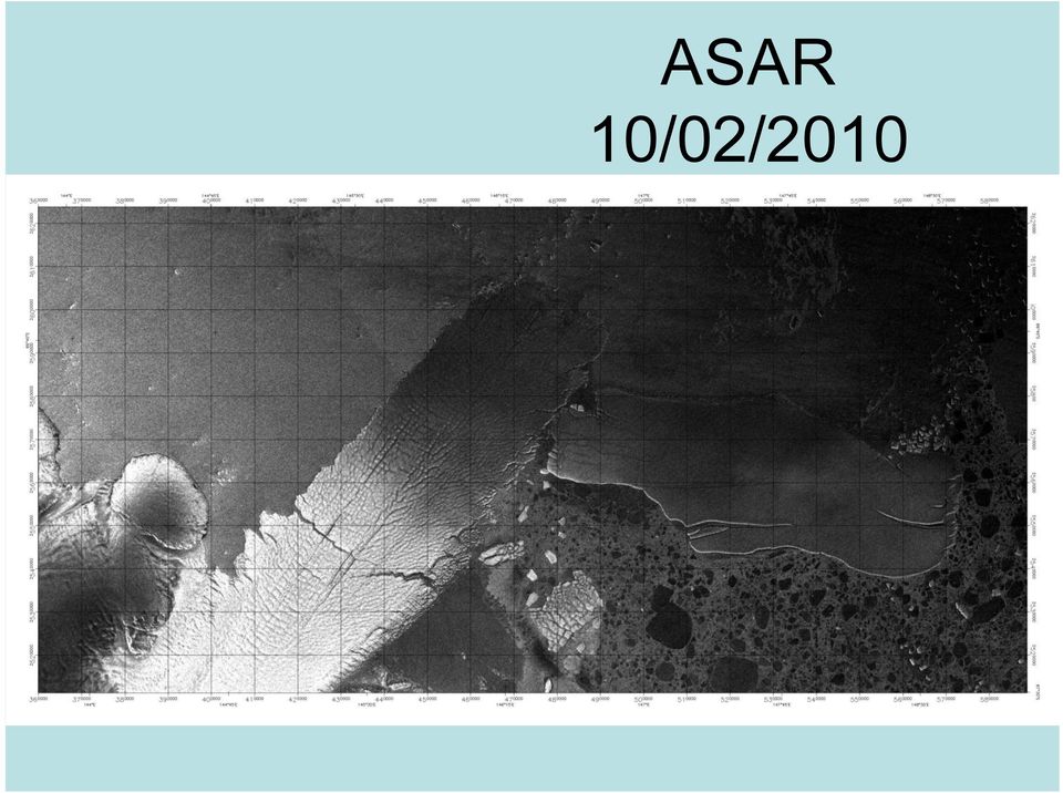
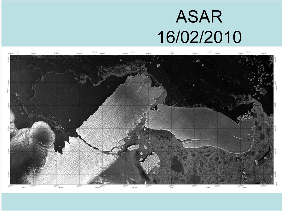
13 The Mertz glacier Tongue calving event of February 2010 seen by ENVISAT ASAR Supporting material include : -A series of ASAR radar images from the ENVISAT satellite (ESA) to illustrate the calving event over the last month
 to illustrate the calving event over the last")
14 ASAR 06/02/2010

15 ASAR 07/02/2010

16 ASAR 10/02/2010
17 ASAR 13/02/2010

18 ASAR 16/02/2010
19 ASAR 19/02/2010

20 ASAR 20/02/2010

21 ASAR 22/02/2010
22 ASAR 23/02/2010
23 ASAR 25/02/2010
24 ASAR 26/02/2010
25 ASAR 01/03/2010
26 ASAR 04/03/2010
27 ASAR 10/03/2010
28 ASAR 14/03/2010
29 ASAR 17/03/2010
30 ASAR 26/03/2010
31 ASAR 01/04/2010
32 ASAR 11/04/2010
33 SPOT-DEM (SPIRIT)+ SPOT HRG + Icesat + Envisat-RA2 + ASAR + MODIS + LANDSAT *Evolution of the crac and the iceberg *Measure the deformation with repeat images thanks to the high resolution *DEM to Improve the ocean geometry knowledge
34
35 + several acquisitions in the last 2 months waiting for isis to get the data
36
37 STD tends to be around 10m when ERS is reliable, better with V2 (inland), courtesy D. Smith (AAD Australian Antarctic Data Center)
38
39
40 It would be convenient to not use a geoid but better an ellipsoid if possible The geoid is very significantly spatially varying in the area
41 Corrected for tides Very significant trends of the geoid ~ 4cm/km 1.0m std
42 Icesat & Envisat compare well, 1m bias at the Xover Different seaice condition, snow over seaice,
43 The large scale topo suits well to the radar profile. The ratio leads to density of A snow thickness of 8+-3% of the total thickness
44
45
46
47
48 Not always systematic link between correlation level and DEM quality
49 Conclusion : * Over the continent where not so much detail is available (but a bit) the quality of the SPIRIT DEM is quite good. * Over Seaice, it is totally unreliable (may be worth masking). * Over the ice tongue, the quality is uneven. It shows really good agreements within few meters and nice features reproduced whle in other places very bad values over 50m out appear. The cc is an indicator and is not an easy flag.? Process, radiometric quality, inclusion of ancillary data into the processing? Can we get the original images to try out making the DEM ourselves?
Radar Interferometric and Polarimetric Possibilities for Determining Sea Ice Thickness
 Radar Interferometric and Polarimetric Possibilities for Determining Sea Ice Thickness by Scott Hensley, Ben Holt, Sermsak Jaruwatanadilok, Jeff Steward, Shadi Oveisgharan Delwyn Moller, Jim Reis, Andy
National Snow and Ice Data Center
 National Snow and Ice Data Center This data set (NSIDC-0484), part of the NASA Making Earth System Data Records for Use in Research Environments (MEaSUREs) Program, provides the first comprehensive, high-resolution,
TerraSAR X and TanDEM X satellite missions update & other activities Dana Floricioiu German Aerospace Center (DLR), Remote Sensing Technology
, Remote Sensing Technology") TerraSAR X and TanDEM X satellite missions update & other activities Dana Floricioiu German Aerospace Center (DLR), Remote Sensing Technology Institute, Oberpfaffenhofen, Germany PSTG 2 12 14 June 2012
TerraSAR X and TanDEM X satellite missions update & other activities Dana Floricioiu German Aerospace Center (DLR), Remote Sensing Technology Institute, Oberpfaffenhofen, Germany PSTG 2 12 14 June 2012
Sentinel-1 Mission Overview
 Sentinel-1 Mission Overview Pierre Potin Sentinel-1 Mission Manager, ESA Advanced Course on Radar Polarimetry ESRIN, Frascati, 19 January 2011 Global Monitoring for Environment and Security GMES is established
How To Monitor Sea Level With Satellite Radar
 Satellite Altimetry Wolfgang Bosch Deutsches Geodätisches Forschungsinstitut (DGFI), München email: bosch@dgfi.badw.de Objectives You shall recognize satellite altimetry as an operational remote sensing
Future needs of remote sensing science in Antarctica and the Southern Ocean: A report to support the Horizon Scan activity of COMNAP and SCAR
 Future needs of remote sensing science in Antarctica and the Southern Ocean: A report to support the Horizon Scan activity of COMNAP and SCAR Thomas Wagner (thomas.wagner@nasa.gov) Charles Webb NASA Cryospheric
GNSS and Heighting, Practical Considerations. A Parker National Geo-spatial Information Department of Rural Development and Land Reform
 GNSS and Heighting, Practical Considerations A Parker National Geo-spatial Information Department of Rural Development and Land Reform GNSS Global Navigation Satellite Systems (GNSS) Global Positioning
How To Help The European Space Program
 Available GOCE Products Brief overview of ESA EO Missions & Programmes Pierre-Philippe Mathieu, ESA-EOP SAGOMA KO Meeting, 24 Nov, Liege, Belgium ESA EO : Overall Framework CCI, STSE GMES EOMD Available
Case Study Australia. Dr John Dawson A/g Branch Head Geodesy and Seismic Monitoring Geoscience Australia. Chair UN-GGIM-AP WG1 Chair APREF.
 Case Study Australia Dr John Dawson A/g Branch Head Geodesy and Seismic Monitoring Geoscience Australia Chair UN-GGIM-AP WG1 Chair APREF Page 1 Overview 1. Australian height system Australian Height Datum
Space radar technologies for oil spills management, detection of illegal fishing and logging activities
 Space radar technologies for oil spills management, detection of illegal fishing and logging activities VIGISAT The French satellite ground receiving station VIGISAT 2009 know today, live better tomorrow
Monitoring a Changing Environment with Synthetic Aperture Radar. Alaska Satellite Facility National Park Service Don Atwood
 Monitoring a Changing Environment with Synthetic Aperture Radar Don Atwood Alaska Satellite Facility 1 Entering the SAR Age 2 SAR Satellites RADARSAT-1 Launched 1995 by CSA 5.6 cm (C-Band) HH Polarization
A remote sensing instrument collects information about an object or phenomenon within the
 Satellite Remote Sensing GE 4150- Natural Hazards Some slides taken from Ann Maclean: Introduction to Digital Image Processing Remote Sensing the art, science, and technology of obtaining reliable information
Determining the Antarctic Ice Sheet Grounding Line with Photoclinometry using LANDSAT Imagery and ICESat Laser Altimetry
 Determining the Antarctic Ice Sheet Grounding Line with Photoclinometry using LANDSAT Imagery and ICESat Laser Altimetry Jamika Baltrop, MyAsia Reid Mentor: Dr. Malcolm LeCompte 1704 Weeksville Road, Box
Earth remote sensing systems of middle and low resolution
 Earth remote sensing systems of middle and low resolution Serial on-line remote sensing satellites delivering data available on the world market V.I. Gershenzon (ScanEx R&D Center) In 1980, graduated from
Near Real Time Blended Surface Winds
 Near Real Time Blended Surface Winds I. Summary To enhance the spatial and temporal resolutions of surface wind, the remotely sensed retrievals are blended to the operational ECMWF wind analyses over the
CLOUD MASKING AND CLOUD PRODUCTS ROUNDTABLE EXPECTED PARTICIPANTS: ACKERMAN, HALL, WAN, VERMOTE, BARKER, HUETE, BROWN, GORDON, KAUFMAN, SCHAAF, BAUM
 CLOUD MASKING AND CLOUD PRODUCTS ROUNDTABLE EXPECTED PARTICIPANTS: ACKERMAN, HALL, WAN, VERMOTE, BARKER, HUETE, BROWN, GORDON, KAUFMAN, SCHAAF, BAUM NOMINAL PURPOSE: DISCUSSION OF TESTS FOR ACCURACY AND
The USGS Landsat Big Data Challenge
 The USGS Landsat Big Data Challenge Brian Sauer Engineering and Development USGS EROS bsauer@usgs.gov U.S. Department of the Interior U.S. Geological Survey USGS EROS and Landsat 2 Data Utility and Exploitation
The Cryosphere. Correspondence to: R. Bindschadler (robert.a.bindschadler@nasa.gov)
") The Cryosphere, 5, 569 588, 2011 doi:10.5194/tc-5-569-2011 Author(s) 2011. CC Attribution 3.0 License. The Cryosphere Getting around Antarctica: new high-resolution mappings of the grounded and freely-floating
The Cryosphere, 5, 569 588, 2011 doi:10.5194/tc-5-569-2011 Author(s) 2011. CC Attribution 3.0 License. The Cryosphere Getting around Antarctica: new high-resolution mappings of the grounded and freely-floating
Quality assessment of tide gauge and altimeter measurements through SSH comparisons
 Quality assessment of tide gauge and altimeter measurements through SSH comparisons M.Ablain, G.Valladeau, CLS A. Lombard, N.Picot - CNES Overview Purpose : SSH comparison from a global approach between
Radar interferometric techniques and data validation Terrafirma Essen, March 2011. Page 1
 Radar interferometric techniques and data validation Terrafirma Essen, March 2011 Page 1 Agenda Introduction to InSAR technology Different radarinterferometric techniques Validation of InSAR technology
AGAP Antarctic Research Project Visualizing Data Learning About Antarctica From RADAR Data? Teacher Version (answers italicized)
") AGAP Antarctic Research Project Visualizing Data Learning About Antarctica From RADAR Data? Teacher Version (answers italicized) Image of Subglacial Lake network courtesy of NSF Ice Sheet: A large glacier
AGAP Antarctic Research Project Visualizing Data Learning About Antarctica From RADAR Data? Teacher Version (answers italicized) Image of Subglacial Lake network courtesy of NSF Ice Sheet: A large glacier
Remote Sensing: Correlating Satellite Images with In-field Observations for Advanced Damage Detection
 Remote Sensing: Correlating Satellite Images with In-field Observations for Advanced Damage Detection ImageCat, Inc. Shubharoop Ghosh Beverley J. Adams, Ph.D. ImageCat, Inc. J. Arn Womble, P.E. Texas Tech
Jason-2 GDR Quality Assessment Report. Cycle 059 07-02-2010 / 17-02-2010. M. Ablain, CLS. P. Thibaut, CLS
 Jason-2 GDR Quality Assessment Report Cycle 059 07-02-2010 / 17-02-2010 Prepared by : S. Philipps, CLS M. Ablain, CLS P. Thibaut, CLS Accepted by : Approved by : DT/AQM, CLS E. Bronner, CNES Edition 01.0,
The European Space Agency s Synthetic Aperture Radar Programme From Experiment to Service Provision
 The European Space Agency s Synthetic Aperture Radar Programme From Experiment to Service Provision Evert Attema ESA, Directorate of Earth Observation Programme! The idea of an independent European space
DESCW: PC Software Supporting Remote Sensing Data
 r bulletin 97 march 1999 DESCW: PC Software Supporting Remote Sensing Data S. D Elia Earth Remote Sensing Exploitation Division, ESA Directorate for Application Programmes, ESRIN, Frascati, Italy R. Biasutti
Data Management Framework for the North American Carbon Program
 Data Management Framework for the North American Carbon Program Bob Cook, Peter Thornton, and the Steering Committee Image courtesy of NASA/GSFC NACP Data Management Planning Workshop New Orleans, LA January
ERS and ENVISAT missions status
 FRINGE 2005 Workshop ERS and ENVISAT missions status Wolfgang Lengert ERS Mission Manager ERS-2 mission 14 years of ERS-1/2 data in the archive (suitable for applications requiring long term series products)
Estimating Firn Emissivity, from 1994 to1998, at the Ski Hi Automatic Weather Station on the West Antarctic Ice Sheet Using Passive Microwave Data
 Estimating Firn Emissivity, from 1994 to1998, at the Ski Hi Automatic Weather Station on the West Antarctic Ice Sheet Using Passive Microwave Data Mentor: Dr. Malcolm LeCompte Elizabeth City State University
Satellites for Terrain Motion Mapping Terrafirma User Workshop Mining. Nico Adam
 Satellites for Terrain Motion Mapping Terrafirma User Workshop Mining Nico Adam Outline SAR / InSAR observation characteristic Sensors TSX, TDX ERS-1, ERS-2 Processing techniques D-InSAR PSI SBAS Acquisition
Data Management for the North American Carbon Program
 Image courtesy of NASA/GSFC Data Management for the North American Carbon Program Bob Cook, Eric Sundquist, Tom Boden,, and Peter Thornton RS in NACP Workshop Missoula, MT August 20, 2004 NACP Data and
From Whitehall to orbit and back again: using space in government
 From Whitehall to orbit and back again: using space in government 18 th June 2014 Bristol 25 th June 2014 Liverpool 3 rd July 2014 -Newcastle Space for Smarter Government Programme (ssgp@sa.catapult.org.uk)
AUTOMATED DEM VALIDATION USING ICESAT GLAS DATA INTRODUCTION
 AUTOMATED DEM VALIDATION USING ICESAT GLAS DATA Mary Pagnutti Robert E. Ryan Innovative Imaging and Research Corp. Building 1103, Suite 140C Stennis Space Center, MS 39529 mpagnutti@i2rcorp.com rryan@i2rcorp.com
SARAL ACCESS TO OFF-LINE DATA
 SARAL AltiKa introduction Plot of the SARAL/AltiKa ground track over Africa (Credits: Google). S ARAL/AltiKa is a new mission in cooperation between CNES and ISRO (Indian Space Research Organization),
Forest Fire Information System (EFFIS): Rapid Damage Assessment
: Rapid Damage Assessment") Forest Fire Information System (EFFIS): Fire Danger D Rating Rapid Damage Assessment G. Amatulli, A. Camia, P. Barbosa, J. San-Miguel-Ayanz OUTLINE 1. Introduction: what is the JRC 2. What is EFFIS 3.
Forest Fire Information System (EFFIS): Fire Danger D Rating Rapid Damage Assessment G. Amatulli, A. Camia, P. Barbosa, J. San-Miguel-Ayanz OUTLINE 1. Introduction: what is the JRC 2. What is EFFIS 3.
Very High Resolution Arctic System Reanalysis for 2000-2011
 Very High Resolution Arctic System Reanalysis for 2000-2011 David H. Bromwich, Lesheng Bai,, Keith Hines, and Sheng-Hung Wang Polar Meteorology Group, Byrd Polar Research Center The Ohio State University
Development of new hybrid geoid model for Japan, GSIGEO2011. Basara MIYAHARA, Tokuro KODAMA, Yuki KUROISHI
 Development of new hybrid geoid model for Japan, GSIGEO2011 11 Development of new hybrid geoid model for Japan, GSIGEO2011 Basara MIYAHARA, Tokuro KODAMA, Yuki KUROISHI (Published online: 26 December 2014)
A tiered reconnaissance approach toward flood monitoring utilising multi-source radar and optical data
 5 th International Workshop on Remote Sensing for Disaster Response A tiered reconnaissance approach toward flood monitoring utilising multi-source radar and optical data Anneley McMillan Dr. Beverley
Antarctica s Pine Island Glacier:
 Keywords: Climate Change at www.scilinks.org Enter code: TST101301 Antarctica s Pine Island Glacier: A Climate Canary? Using atmospheric and oceanic processes and the poles to teach the climate system
Authors: Thierry Phulpin, CNES Lydie Lavanant, Meteo France Claude Camy-Peyret, LPMAA/CNRS. Date: 15 June 2005
 Comments on the number of cloud free observations per day and location- LEO constellation vs. GEO - Annex in the final Technical Note on geostationary mission concepts Authors: Thierry Phulpin, CNES Lydie
The use of Satellite Remote Sensing for Offshore Environmental Benchmarking
 The use of Satellite Remote Sensing for Offshore Environmental Benchmarking Michael King Fugro NPA Limited Fugro NPA (Formerly Nigel Press Associates) World leading Satellite Remote Sensing & Geoscience
EO based glacier monitoring
 EO based glacier monitoring THEMES 1. WGMS & GLIMS within GTN G: strategic set up 2. GlobGlacier & Glaciers_cci: EO based products 3. LDCM & Sentinel 2: future monitoring perspectives Frank Paul* Department
Evolving a new Geodetic Positioning Framework: An Australian Perspective
 Evolving a new Geodetic Positioning Framework: An Australian Perspective G. Johnston, J. Dawson Outline Introduction Precise Positioning National Geospatial Reference Systems Asia Pacific Reference Frame
Storm tide is the water level rise during a storm due to the combination of storm surge and the astronomical tide.
 INTRODUCTION TO STORM SURGE Introduction to Storm Surge BOLIVAR PENINSULA IN TEXAS AFTER HURRICANE IKE (2008) What is Storm Surge? Inland Extent Storm surge can penetrate well inland from the coastline.
Cloud Masking and Cloud Products
 Cloud Masking and Cloud Products MODIS Operational Algorithm MOD35 Paul Menzel, Steve Ackerman, Richard Frey, Kathy Strabala, Chris Moeller, Liam Gumley, Bryan Baum MODIS Cloud Masking Often done with
Example of an end-to-end operational. from heat waves
 Example of an end-to-end operational service in support to civil protection from heat waves Paolo Manunta pkt006-11-1.0 1.0_WEBGIS Athens, 8 June 2007 OUTLINE Heat Island definition and causes Heat Island
Storm tide is the water level rise during a storm due to the combination of storm surge and the astronomical tide.
 INTRODUCTION TO STORM SURGE Introduction to Storm Surge National Hurricane Center Storm Surge Unit BOLIVAR PENINSULA IN TEXAS AFTER HURRICANE IKE (2008) What is Storm Surge? Inland Extent Storm surge can
Gravitational potential
 Gravitational potential Let s assume: A particle of unit mass moving freely A body of mass M The particle is attracted by M and moves toward it by a small quantity dr. This displacement is the result of
How To Find Natural Oil Seepage In The Dreki Area Using An Envisat Image
 rn ORKUSTOFNUN National Energy Authority Searching for natural oil seepage in the Dreki area using ENVISAT radar images. Ingibjorg J6nsd6ttir and Arni Freyr Valdimarsson, Faculty of Earth Sciences School
GLOBAL MONITORING FOR FOOD SECURITY IM SUDAN
 GLOBAL MONITORING FOR FOOD SECURITY IM SUDAN GMFS 3 Carsten Haub & Klaus-Ulrich Komp 18.11.2010 www.eftas.com 1 World hunger World Summit on Food Security FAO, Rome 11.2009 Mehr als 1 Milliarde Mensche
Chapter Overview. Seasons. Earth s Seasons. Distribution of Solar Energy. Solar Energy on Earth. CHAPTER 6 Air-Sea Interaction
 Chapter Overview CHAPTER 6 Air-Sea Interaction The atmosphere and the ocean are one independent system. Earth has seasons because of the tilt on its axis. There are three major wind belts in each hemisphere.
Breer i Arktis og globale havnivåendringer. Jon Ove Hagen Institutt for geofag Universitetet i Oslo
 Breer i Arktis og globale havnivåendringer Jon Ove Hagen Institutt for geofag Universitetet i Oslo Bresmelting Svalbard 1928 2002 (from NP and Greenpeace) Blomstrandbreen, Svalbard Typisk Svalbard bre:
ESA Climate Change Initiative contributing to the Global Space-based Architecture for Climate Monitoring
 ESA Climate Change Initiative contributing to the Global Space-based Architecture for Climate Monitoring Pascal Lecomte Head of the ESA Climate Office ESA/ECSAT Global Space-based Architecture for Climate
Developments toward a European Land Monitoring Framework. Geoff Smith. Seminar 2 nd December, 2015 Department of Geography, University of Cambridge
 Developments toward a European Land Monitoring Framework Geoff Smith Specto Natura Limited Enable clients to deliver useful, accurate and reliable environmental information from EO. Positioned at the interface
16 th IOCCG Committee annual meeting. Plymouth, UK 15 17 February 2011. mission: Present status and near future
 16 th IOCCG Committee annual meeting Plymouth, UK 15 17 February 2011 The Meteor 3M Mt satellite mission: Present status and near future plans MISSION AIMS Satellites of the series METEOR M M are purposed
Global Cryosphere Watch (GCW): A WMO Initiative
: A WMO Initiative") Global Cryosphere Watch (GCW): A WMO Initiative IICWG 10 th Meeting, Geneva, Switzerland October 12-16, 2009 Barry Goodison, Chair, GCW Expert Team presented by Vladimir Ryabinin (WCRP) Global Cryosphere
Global Cryosphere Watch (GCW): A WMO Initiative IICWG 10 th Meeting, Geneva, Switzerland October 12-16, 2009 Barry Goodison, Chair, GCW Expert Team presented by Vladimir Ryabinin (WCRP) Global Cryosphere
SCAR WG-GGI NATIONAL REPORT FOR AUSTRALIA. Report of Current Activities of Australia in Geodesy and Geographic Information for the period 1998-2000
 SCAR WG-GGI NATIONAL REPORT FOR AUSTRALIA Report of Current Activities of Australia in Geodesy and Geographic Information for the period 1998-2000 Prepared by Glenn Johnstone and John Manning, AUSLIG and
Temporal and spatial evolution of the Antarctic sea ice prior to the September 2012 record maximum extent
 GEOPHYSICAL RESEARCH LETTERS, VOL. 40, 5894 5898, doi:10.1002/2013gl058371, 2013 Temporal and spatial evolution of the Antarctic sea ice prior to the September 2012 record maximum extent John Turner, 1
Senior Advisor for EO Applications, ESA-ESRIN
 Accesso e utilizzo di dati OsservazioneTerra: prospettivegrid Luigi.Fusco@esa.int Senior Advisor for EO Applications, ESA-ESRIN IV Incontro di GARR-B Bologna June 24-26, 2002 Summary ESA and Earth Observation
GOES-R AWG Cloud Team: ABI Cloud Height
 GOES-R AWG Cloud Team: ABI Cloud Height June 8, 2010 Presented By: Andrew Heidinger 1 1 NOAA/NESDIS/STAR 1 Outline Executive Summary Algorithm Description ADEB and IV&V Response Summary Requirements Specification
COASTAL ALTIMETRY AT THE CENTRE DE TOPOGRAPHIE DES OCEANS ET DE L HYDROSPHERE
 COASTAL ALTIMETRY AT THE CENTRE DE TOPOGRAPHIE DES OCEANS ET DE L HYDROSPHERE Florence Birol, Caroline Delebecque, Laurent Roblou, Sara Fleury, Rosemary Morrow, Fernando Niño and Guillaume Pernot http://ctoh.legos.obs-mip.fr/
INVESTIGA I+D+i 2013/2014
 INVESTIGA I+D+i 2013/2014 SPECIFIC GUIDELINES ON AEROSPACE OBSERVATION OF EARTH Text by D. Eduardo de Miguel October, 2013 Introducction Earth observation is the use of remote sensing techniques to better
Remote Sensing of Clouds from Polarization
 Remote Sensing of Clouds from Polarization What polarization can tell us about clouds... and what not? J. Riedi Laboratoire d'optique Atmosphérique University of Science and Technology Lille / CNRS FRANCE
Resolutions of Remote Sensing
 Resolutions of Remote Sensing 1. Spatial (what area and how detailed) 2. Spectral (what colors bands) 3. Temporal (time of day/season/year) 4. Radiometric (color depth) Spatial Resolution describes how
Earth Science & Environmental Science SOL
 Earth Science & Environmental Science SOL THE SOL FOR GRADE 6 The Virginia Science SOL for Grades K 6 are organized according to a set of strands, with the SOL in each strand developed progressively through
SARscape 4.3 Supported Sensors/Products (March 2011) - Spaceborne Sensors -
 - Spaceborne Sensors -") SARscape 4.3 Supported Sensors/Products (March 2011) - Spaceborne Sensors - ALOS PALSAR (provided by JAXA) In case of RAW (level 1.0) data, import is carried out within the Focusing Module. PALSAR RAW
SARscape 4.3 Supported Sensors/Products (March 2011) - Spaceborne Sensors - ALOS PALSAR (provided by JAXA) In case of RAW (level 1.0) data, import is carried out within the Focusing Module. PALSAR RAW
Marine route optimization. Jens Olaf Pepke Pedersen Polar DTU / DTU Space www.polar.dtu.dk www.space.dtu.dk
 Marine route optimization Jens Olaf Pepke Pedersen Polar DTU / DTU Space www.polar.dtu.dk www.space.dtu.dk Early attempt at route optimization Jens Munk (1579-1628) Tries to find a way to India through
Review for Introduction to Remote Sensing: Science Concepts and Technology
 Review for Introduction to Remote Sensing: Science Concepts and Technology Ann Johnson Associate Director ann@baremt.com Funded by National Science Foundation Advanced Technological Education program [DUE
Prediction of Storm Surge using Space Data. Susanne Lehner German Aerospace Center
 Prediction of Storm Surge using Space Data Susanne Lehner German Aerospace Center Existing Crisis Information State of the Art of Satellite Crisis Information (ZKI) Mapping after the storm www.zki.de
NASA Earth System Science: Structure and data centers
 SUPPLEMENT MATERIALS NASA Earth System Science: Structure and data centers NASA http://nasa.gov/ NASA Mission Directorates Aeronautics Research Exploration Systems Science http://nasascience.nasa.gov/
GSA Data Repository 2016022 An extensive subglacial lake and canyon system in Princess Elizabeth Land, East Antarctica
 GSA Data Repository 2016022 An extensive subglacial lake and canyon system in Princess Elizabeth Land, East Antarctica Stewart S.R. Jamieson 1,*, Neil Ross 2, Jamin S. Greenbaum 3, Duncan A. Young 3, Alan
Monitoring of the Arctic by Remote Sensing
 Monitoring of the Arctic by Remote Sensing Arctic Conference: Challenges And Opportunities For Norway 10 May 2012, Oslo Militære Samfund Stian Solbø, Rune Storvold and Harald Johnsen Northern Research
APPLICATION OF TERRA/ASTER DATA ON AGRICULTURE LAND MAPPING. Genya SAITO*, Naoki ISHITSUKA*, Yoneharu MATANO**, and Masatane KATO***
 APPLICATION OF TERRA/ASTER DATA ON AGRICULTURE LAND MAPPING Genya SAITO*, Naoki ISHITSUKA*, Yoneharu MATANO**, and Masatane KATO*** *National Institute for Agro-Environmental Sciences 3-1-3 Kannondai Tsukuba
ICE CALVING AND DEFORMATION FROM ANTARCTIC ICE MARGINS USING RISAT-1 CIRCULAR POLARIZATION SAR DATA
 ICE CALVING AND DEFORMATION FROM ANTARCTIC ICE MARGINS USING RISAT-1 CIRCULAR POLARIZATION SAR DATA P. Jayaprasad*, D. Ram Rajak, Rajkumar Kamaljit Singh, Sandip R. Oza, Rashmi Sharma and Raj Kumar Atmospheric
Slide 1. Slide 2. Slide 3
 Satellite Analysis of Sea Surface Temperatures in the Florida Keys to Monitor Coral Reef Health NASA Stennis Space Center Earthzine/DEVELOP Virtual Poster Session, Summer 2011 Video Transcript Slide 1
The use of Earth Observation technology to support the implementation of the Ramsar Convention
 Wetlands: water, life, and culture 8th Meeting of the Conference of the Contracting Parties to the Convention on Wetlands (Ramsar, Iran, 1971) Valencia, Spain, 18-26 November 2002 COP8 DOC. 35 Information
Studying cloud properties from space using sounder data: A preparatory study for INSAT-3D
 Studying cloud properties from space using sounder data: A preparatory study for INSAT-3D Munn V. Shukla and P. K. Thapliyal Atmospheric Sciences Division Atmospheric and Oceanic Sciences Group Space Applications
Long Term Preservation of Earth Observation Data
 Long Term Preservation of Earth Observation Data QA4EO Workshop RAL, October 18-20 th 2011 Mirko Albani and Bojan Bojkov* (ESA/ESRIN) Page 1 Outline Earth Observation data preservation: the need and the
Wide Area Persistent Scatterer Interferometry: Algorithms and Examples
 Wide Area Persistent Scatterer Interferometry: Algorithms and Examples Nico Adam, Fernando Rodriguez Gonzalez, Alessandro Parizzi, Werner Liebhart with contributions of Ramon Brcic and Xiao Ying Cong ca.
THE CURRENT EVOLUTIONS OF THE DORIS SYSTEM
 THE CURRENT EVOLUTIONS OF THE DORIS SYSTEM TAVERNIER, G.; GRANIER, J.P.; JAYLES, C.; SENGENES, P. (CNES) ROZO, F. (COFRAMI) presented by P. VINCENT (CNES) Table of Contents System and Missions Satellites:
ESA Earth Observation and the need for high speed networking
 ESA Earth Observation and the need for high speed networking Pisa, 11 th May 25 11 th May 25 GARR Conference 5 1 ESA Earth Observation 11 th May 25 GARR Conference 5 2 The European Space Agency The European
Mission Operations and Ground Segment
 ESA Earth Observation Info Days Mission Operations and Ground Segment ESA EO Ground Segment and Mission Operations department (EOP-G) May 2013 EOEP 2013 Page 1 ESA Unclassified For Official Use MISSION
Operational Space- Based Crop Mapping Protocols at AAFC A. Davidson, H. McNairn and T. Fisette.
 Operational Space- Based Crop Mapping Protocols at AAFC A. Davidson, H. McNairn and T. Fisette. Science & Technology Branch. Agriculture and Agri-Food Canada. 1. Introduction Space-Based Crop Mapping at
Satellite Altimetry Missions
 Satellite Altimetry Missions SINGAPORE SPACE SYMPOSIUM 30 TH SEPTEMBER 2015 AUTHORS: LUCA SIMONINI/ ERICK LANSARD/ JOSE M GONZALEZ www.thalesgroup.com Table of Content General Principles and Applications
The accuracy of digital elevation models of the Antarctic continent
 Earth and Planetary Science Letters 237 (200) 16 23 www.elsevier.com/locate/epsl The accuracy of digital elevation models of the Antarctic continent Jonathan Bamber *, Jose Luis Gomez-Dans Centre for Polar
Unveiling the disaster. A satellite based habitat impact assessment of the Deepwater Horizon Oil Spill
 Unveiling the disaster A satellite based habitat impact assessment of the Deepwater Horizon Oil Spill Gulf of Mexico Background of the disaster The Gulf oil spill situation has evolved, and so have the
Severe Weather & Hazards Related Research at CREST
 Severe Weather & Hazards Related Research at CREST (Lead Scientists) Z. Johnny Luo, Nir Krakauer, Shayesteh Mahani, Fabrice Papa, Marouane Temimi and Brian Vant Hull (NOAA Collaborators) Arnold Gruber,
2. D ata and Method 2.1 A long-track processing
 1Dynamic thinning of Antarctic glaciers from along-track repeat radar 2altimetry 3 4 5Thomas Flament, LEGOS, 14 Avenue E. Belin, 31400 Toulouse France 6Frédérique Rémy, LEGOS, 14 Avenue E. Belin, 31400
Tectonic plates push together at convergent boundaries.
 KEY CONCEPT Plates converge or scrape past each other. BEFORE, you learned Plates move apart at divergent boundaries In the oceans, divergent boundaries mark where the sea floor spreads apart On land,
Andrea Bondì, Irene D Urso, Matteo Ombrelli e Paolo Telaroli (Thetis S.p.A.) Luisa Sterponi e Cesar Urrutia (Spacedat S.r.l.) Water Calesso (Marco
 Luisa Sterponi e Cesar Urrutia (Spacedat S.r.l.) Water Calesso (Marco") Generation of a digital elevation model of the Wadi Lebda basin, Leptis Magna - Lybia Andrea Bondì, Irene D Urso, Matteo Ombrelli e Paolo Telaroli (Thetis S.p.A.) Luisa Sterponi e Cesar Urrutia (Spacedat
Generation of a digital elevation model of the Wadi Lebda basin, Leptis Magna - Lybia Andrea Bondì, Irene D Urso, Matteo Ombrelli e Paolo Telaroli (Thetis S.p.A.) Luisa Sterponi e Cesar Urrutia (Spacedat
Antenna Chetumal: Use of remote sensing data for environmental and civil security applications in Mexico. 22 nd to 24 th of April, 2008
 Antenna Chetumal: Use of remote sensing data for environmental and civil security applications in Mexico 22 nd to 24 th of April, 2008 Location: International Conference Center (ICC). Ciudad de México
Understanding image scale and resolution
 Understanding image scale and resolution Ned Horning Version: 1.0 Creation Date: 2004-01-01 Revision Date: 2004-01-01 License: This document is licensed under a Creative Commons Attribution-Share Alike
Multiangle cloud remote sensing from
 Multiangle cloud remote sensing from POLDER3/PARASOL Cloud phase, optical thickness and albedo F. Parol, J. Riedi, S. Zeng, C. Vanbauce, N. Ferlay, F. Thieuleux, L.C. Labonnote and C. Cornet Laboratoire
Name Period 4 th Six Weeks Notes 2015 Weather
 Name Period 4 th Six Weeks Notes 2015 Weather Radiation Convection Currents Winds Jet Streams Energy from the Sun reaches Earth as electromagnetic waves This energy fuels all life on Earth including the
Towards assimilating IASI satellite observations over cold surfaces - the cloud detection aspect
 Towards assimilating IASI satellite observations over cold surfaces - the cloud detection aspect Tuuli Perttula, FMI + Thanks to: Nadia Fourrié, Lydie Lavanant, Florence Rabier and Vincent Guidard, Météo
CMEMS user requirements and user uptake strategy
 CMEMS Service Evolution & User Uptake Workshop CMEMS user requirements and user uptake strategy Dominique Obaton Mercator Océan CMEMS Service Evolution & User Uptake Workshop The Copernicus Marine service
SPOT4 (Take 5) first validation and application results
 first validation and application results") SPOT4 (Take 5) first validation and application results O.Hagolle CESBIO/CNES, M.Huc CESBIO/CNRS, M.Kadiri CESBIO/THEIA ; J.Inglada CESBIO/CNES, C. Marais-Sicre CESBIO/CNRS, J.Osman CESBIO/CNES (PhD),
SPOT4 (Take 5) first validation and application results O.Hagolle CESBIO/CNES, M.Huc CESBIO/CNRS, M.Kadiri CESBIO/THEIA ; J.Inglada CESBIO/CNES, C. Marais-Sicre CESBIO/CNRS, J.Osman CESBIO/CNES (PhD),
ACCESS TO ERS AND ENVISAT DATA. CGMS is informed about the ESA Earth Observation data policy and data access, in particular in Near Real Time.
 Prepared by ESA Agenda Item: III.3 Discussed in WG3 ACCESS TO ERS AND ENVISAT DATA CGMS is informed about the ESA Earth Observation data policy and data access, in particular in Near Real Time. ACCESS
MSDI: Workflows, Software and Related Data Standards
 MSDI: Workflows, Software and Related Data Standards By Andy Hoggarth October 2009 Introduction Leveraging SDI principles for hydrographic operational efficiency French INFRAGEOS example (SHOM - Service
TIDES. 1. Tides are the regular rise and fall of sea level that occurs either once a day (every 24.8 hours) or twice a day (every 12.4 hours).
 or twice a day (every 12.4 hours).") TIDES What causes tides? How are tides predicted? 1. Tides are the regular rise and fall of sea level that occurs either once a day (every 24.8 hours) or twice a day (every 12.4 hours). Tides are waves
TIDES What causes tides? How are tides predicted? 1. Tides are the regular rise and fall of sea level that occurs either once a day (every 24.8 hours) or twice a day (every 12.4 hours). Tides are waves
Cartographic Challenges in Antarctica: Mapping in Support of Environmental Management for the US Antarctic Program
 Cartographic Challenges in Antarctica: Mapping in Support of Environmental Management for the US Antarctic Program Katharina Lorenz*, Dr Colin M Harris* * Environmental Research & Assessment, Cambridge,