Measuring San José s Community Forest: a Collaborative Effort. Elizabeth Lanham Arborist Technician City of San José, Department of Transportation
|
|
|
- Griselda Gardner
- 8 years ago
- Views:
Transcription
1 Measuring San José s Community Forest: a Collaborative Effort Elizabeth Lanham Arborist Technician City of San José, Department of Transportation

2 Agenda Pilot Study I-Tree Streets Results Database Development Training Data Collection The AmeriCorps Group Managing the Members Quality Control and Program Results Advantages, Limitations, and Lessons Learned

3 Founded in 1777 Approximately 180 square miles Over 1 million people (January, 2008) City of San José
")
4 Inventory Interest Grows Previous inventory efforts inconclusive estimated 230,000 to 343,000 street trees Mayor s Green Vision objective to plant 100,000 new street trees by 2022 Interest in developing a Citywide street tree management plan

5 Project Purposes Develop a complete and accurate street tree inventory Find vacant planting sites to help satisfy Green Vision goals Data to help develop San José Community Forest Master Plan

6 First Phase of the Inventory 1. Intern-based pilot study 2. Community service, zone-based inventory (AmeriCorps members hired through Our City Forest) 3. Davey Resource Group inventory of commercial zones and Special Assessment Districts

7 Pilot Study February through November, 2009 Four student interns tested equipment, data collection, and database structure 3% I-Tree Streets sample

8 Equipment and Tools

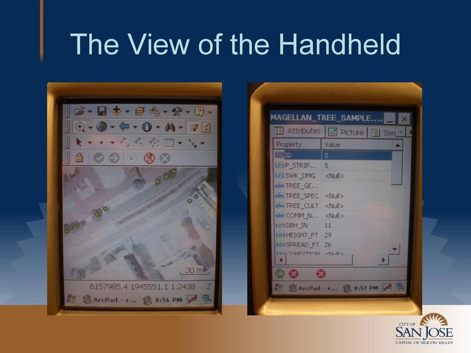
9 The View of the Handheld
10 Interns Hard at Work. Graduate Student Intern Igor Lacan Undergraduate Student Intern Richard Lescalleet

11 Results of I-Tree Streets Sample Estimated 242,650 street trees Average annual benefits of approximately $24 million ($98 per tree) About 3,600 acres of estimated canopy cover
 About 3,600 acres of estimated")
12 Inferences from Pilot Study ArcPad program can be challenging High-cost, professional-grade equipment not necessary A GPS-tracked aerial photo with a simplified inventory form is key

13 Data Collection Materials Pocket PC Bluetooth-enabled GPS device TierraMapper mobile GIS Visual CE Professional

14 Database and Data Collection Aerial photo tracked with TierraMapper Simplified data collection form - version of Pilot Study Desktop database in Microsoft Access compatible with previously collected data

15 TierraMapper and Visual CE

16 AmeriCorps Community Service Members 16 AmeriCorps service members hired through Our City Forest Majority heard of position through Craigslist Very little prior knowledge or training

17 The AmeriCorps Team

18 Training Methods Tree tours led by City Arborist Hands-on equipment training in small groups Data analysis each day after equipment training

19 Training Materials Municipal codes and city policies handouts McMinn and Maino s Illustrated Manual of Pacific Coast Trees (1956) Specially developed photographic guide of local trees
 Specially developed photographic guide")
20 Getting Started Training lasted about two weeks First locations were close to home-base Heavy monitoring for first few days

21 Managing AmeriCorps Tree Inventory Specialists Inventory
22 Managing AmeriCorps Tree Inventory Specialists One point-of-contact - additional assistance obtained as necessary Frequent team check-ins and weekly group meetings Members allowed freedom to set own schedules, provided work was completed in a timely manner
23 Quality Control 1% sample selected for Quality Control (to be expanded to 3% if necessary) Site revisits with spreadsheets of collected data and evaluation forms
24 Program Evaluation Most errors were minor omissions of hardscape issues or minor measurement errors Very few massive measurement errors or species identification problems found in data QC efforts show the data collected to be approximately 97% accurate!
25 First Phase Inventory Results About 124,000 total records collected Approximately 38% of the City inventoried Average cost per-site was $1.96 (AmeriCorps and Student Interns)
26 City s Inventory First Phase
27 Advantages of a Community Service-Based Inventory Potential for high productivity Cost-effective Helped raise community awareness of City policies and inventory efforts AmeriCorps Members Carolyn Tucker and Tristan McHenry Photo courtesy of Our City Forest
28 Limitations to Working with Community Service Members Program may require extensive training, which could delay start date Considerable supervision necessary for successful program operation Preparatory work may be very intensive
29 Important Lessons Learned Collaborate with your local non-profit organization Work with people s existing strengths and be aware that your program might not be for everyone Frequent meetings and discussions are an essential part of program success
30 Thank You! Elizabeth Lanham Arborist Technician City of San José, Department of Transportation
Presented at American Forests National Urban Forest Conference San Antonio, TX, September 17, 2003
 Presented at American Forests National Urban Forest Conference San Antonio, TX, September 17, 2003 Handheld Technologies for Urban Forestry - Inventories, GIS, & More by David V. Bloniarz, USDA Forest
Community Tree Inventory: Data Collection
 USDA FOREST SERVICE NORTHEAST CENTER FOR URBAN & COMMUNITY FORESTRY www.umass.edu/urbantree Community Tree Inventory: Data Collection An Introduction - July 2002 United States Department of Agriculture
TwoDog Forest Inventory Software. Complete Field to Office Forest Inventory Solution for Timber and Non-Timber Values
 TwoDog Forest Inventory Software Complete Field to Office Forest Inventory Solution for Timber and Non-Timber Values TwoDog Forest Inventory Software Complete Field to Office Forest Inventory Solution
Infrastructure Asset Management. CEAM Conference January 25, 2012 Jim Engfer Stantec 651-604-4819 James.engfer@stantec.com
 Infrastructure Asset Management CEAM Conference January 25, 2012 Jim Engfer Stantec 651-604-4819 James.engfer@stantec.com Infrastructure Asset Management You can t afford not to do it Description of Geographic
Pima Regional Remote Sensing Program
 Pima Regional Remote Sensing Program Activity Orthophoto GIS Mapping and Analysis Implementing Agency Pima Association of Governments (Tucson, Arizona area Metropolitan Planning Organization) Summary Through
Community Greenscapes & Trails
 Parks and Recreation Department Parks Operations Division Community Greenscapes & Trails P&R Director: Donna Gaukler Urban Forester: Greg Howe Page 1 Greg Howe Urban Forester Urban Forester - City of Missoula
8/4/2014. Mobile GIS for Public Works. Ames, Iowa. Background. 2014 APWA National Congress
 Ben McConville, GIS Coordinator City of Ames Public Works Department Mobile GIS for Public Works Corey Mellies, P.E., Operations Manager City of Ames Public Works Department 2014 APWA National Congress
City Tree Inventory: The Experience of a Small Town
 Southern Regional Extension Forestry A Regional Peer Reviewed Technology Bulletin SREF-UF-001 November 2008 City Tree Inventory: The Experience of a Small Town Dr. David W. Long, Assistant Professor, School
A GUIDE: DEVELOPING A STREET AND PARK TREE MANAGEMENT PLAN
 A GUIDE: DEVELOPING A STREET AND PARK TREE MANAGEMENT PLAN An introduction to the preparation of a strategic approach to the care and maintenance of your community forest USDA Forest Service Northeastern
From GPS Data Collection to GIS Data Display A Walk-Through Example
 From GPS Data Collection to GIS Data Display A Walk-Through Example The Global Positioning System (GPS) is a satellite based navigation system consisting of 24 satellites, a worldwide network of tracking
Comparison of Urban Forest Inventory & Management Software Systems 1
 FOR226 Comparison of Urban Forest Inventory & Management Software Systems 1 Michael G. Andreu, Erin M. Brown, Melissa H. Friedman, Robert J. Northrop, and Mary E. Thornhill 2 Background In 1997, Olig and
CONNECT PLAN PROTECT ENGAGE MANAGE
 Our urban forest is comprised of all trees on private and public lands within the city boundaries; these trees improve the environment and make our a more desirable place to live, work, and play. Many
Benefits of Mobile GIS for Public Works
 Benefits of Mobile GIS for Public Works Freese and Nichols, Inc. NCAFPM 2013 Agenda General GIS Concepts Mobile GIS Overview Benefits of Mobile GIS Mobile GIS Project Examples Questions What is GIS? Geographic
Introduction to ArcPad: Mobile GIS. Originally prepared by Gregory Vandeberg, Ph.D. Department of Geography
 Introduction to ArcPad: Mobile GIS Originally prepared by Gregory Vandeberg, Ph.D. Department of Geography Outline Introduction What is ArcPad? What can you do with ArcPad? What do you need to run it?
Street Tree Seminar WTMS Summer Program
 Street Tree Seminar WTMS Summer Program Santa Monica s Long Range Urban Forest Plan Walt Warriner Community Forester City of Santa Monica, California www.santamonicatrees.com facebook.com/smtrees Long
City of Cambridge Climate Protection Action Committee. Recommendation to the City Manager on Urban Heat Island Mitigation
 City of Cambridge Climate Protection Action Committee Recommendation to the City Manager on Urban Heat Island Mitigation Recommendation to take actions that mitigate and increase awareness of the urban
SAN JOSE CAPITAL OF SILICON VALLEY
 T&E Committee: 11/03/2014 Item: (d) (5) CITY OF SAN JOSE CAPITAL OF SILICON VALLEY TO: TRANSPORTATION AND ENVIRONMENT COMMITTEE SUBJECT: SEE BELOW Memorandum FROM: Keme Romanow DATE: October 17,2014 Approved
Nevada Shade Tree Council 2011 STRATEGIC PLAN Adopted February 4, 2011 THREATS/ISSUES AFFECTING NEVADA S URBAN FORESTS
 Nevada Shade Tree Council 2011 STRATEGIC PLAN Adopted February 4, 2011 Nevada Division of Forestry (NDF), the Nevada Shade Tree Council (NSTC) and others interested in urban forestry met in April 2007
3 September 9, 2015 Public Hearing
 3 September 9, 2015 Public Hearing APPLICANT: PI TELECOM INFRASTRUCTURE T, LLC PROPERTY OWNER: JSW HOLDINGS, LLC STAFF PLANNER: Carolyn A.K. Smith REQUEST: Conditional Use Permit (communications tower-monopole)
USE OF GIS AS A REAL TIME DECISION SUPPORT SYSTEM FOR IRRIGATION DISTRICTS. Gabriele Bonaiti, Ph.D. 1 Guy Fipps, Ph.D., P.E.
 USE OF GIS AS A REAL TIME DECISION SUPPORT SYSTEM FOR IRRIGATION DISTRICTS Gabriele Bonaiti, Ph.D. 1 Guy Fipps, Ph.D., P.E. 2 ABSTRACT GIS technology has been utilized in the past years by drainage and
Tree Inventories: In the Palm of Your Hand. Tree Care Technology. Introduction
 Tree Care Technology A personal digital assistant (PDA) provides a low-cost alternative to more expensive systems for collecting data on public and private trees. Many PDA programs are available for use
Fort Wayne Emerald Ash Borer
 Fort Wayne Emerald Ash Borer City of Fort Wayne As of December 8, 2010, there are54,610 street trees in the city limits There are over 157 different varieties of street trees. These are trees in the right
What Are Other Campuses Doing?
 What Are Other Campuses Doing? Kent State University at Stark: As a part of their campus outreach initiatives, KSU- Stark students created these tags using the USDA Forest Service s i-tree (www.itreetools.org)
Conducting a Land Use Inventory
 Chapter 3 Conducting a Land Use Inventory Included in this chapter: Determining Current Land Use Conditions Preparing a Base Map Deciding on Land Use Categories Collecting Current Land Use Data Preparing
UDRB APPLICATION URBAN DEVELOPMENT REVIEW BOARD
 UDRB APPLICATION CITY OF MIAMI VISION STATEMENT: To Be an International City that Embodies Diversity, Economic Opportunity, Effective Customer Service and a Highly Rated Quality of Life OBJECTIVE: The
Application of a web-based Environmental Data Management System at The Department of Energy s Naval Petroleum Reserves No.2
 Application of a web-based Environmental Data Management System at The Department of Energy s Naval Petroleum Reserves No.2 Agenda NPR-2 Background Overview of webedms Application of webedms to NPR-2 Creation
Curriculum Vitae Nathan Daniel McClure
 Curriculum Vitae Nathan Daniel McClure Forest Utilization Department Georgia Forestry Commission P.O. Box 819, Macon, Georgia 31202 Direct line: 1(478)-951-4548 Personal Contact: P.O. Box 1068 Dahlonega,
Urban Ecosystem Analysis Atlanta Metro Area Calculating the Value of Nature
 August 2001 Urban Ecosystem Analysis Atlanta Metro Area Calculating the Value of Nature Report Contents 2 Project Overview and Major Findings 3 Regional Analysis 4 Local Analysis 6 Using Regional Data
City of Atlanta CLIMATE ACTION PLAN
 City of Atlanta CLIMATE ACTION PLAN Jairo Garcia, Ed.D. Mayor s Office of Sustainability August 7, 2015 Agenda 1. Overview Office of Sustainability 2. Overview Climate Action Plan 3. Climate Impacts a.
The Firewise Curriculum in Minnesota Schools. William J. Glesener
 The Firewise Curriculum in Minnesota Schools William J. Glesener 1 Items for discussion: Background Goals Philosophy Assessment Process Future Developments (Desires) 2 Background The MNDNR adopts the national
Urban Ecosystem Services Seattle s Urban Forest
 Urban Ecosystem Services Seattle s Urban Forest Dr. Kathleen Wolf Dr. Dale Blahna University of Washington, College of the Environment USDA Forest Service, Pacific NW Research Station Laos/Cambodia Study
How To Be A Gis Director
 Summaries of Duties Typically Associated With Different Kinds of GIS-Related Jobs Reference: Huxhold, W. (ed), 2000. Model Job Descriptions for GIS Professionals, Urban and Regional Information Systems
Extending Enterprise GIS Into The Field with Mobile GIS Technology
 Extending Enterprise GIS Into The Field with Mobile GIS Technology A White Paper January 10, 2014 1525 Oregon Pike Suite 202 Lancaster, PA 17601-7300 Phone (717) 399-7007 Fax (717) 399-7015 www.geographit.com
MAPPING MINNEAPOLIS URBAN TREE CANOPY. Why is Tree Canopy Important? Project Background. Mapping Minneapolis Urban Tree Canopy.
 MAPPING MINNEAPOLIS URBAN TREE CANOPY Why is Tree Canopy Important? Trees are an important component of urban environments. In addition to their aesthetic value, trees have significant economic and environmental
Integrating Maryland s s Transportation Asset Management into Maintenance and Environment
 Maryland Department of Transportation State Highway Administration Integrating Maryland s s Transportation Asset Management into Maintenance and Environment Sonal Sanghavi, P.E. Director, Office of Environmental
Wildland Fire Decision Support Tools
 Wildland Fire Decision Support Tools Numerous support tools for intelligence gathering and analyses are readily available to aid fire managers and administrators in making risk informed decisions. These
PHOTO: Jon Waterman THE COLORADO RIVER DELTA, CIRCA NOW OPEN BOOKLET TO SEE CHANGE
 PHOTO: Jon Waterman THE COLORADO RIVER DELTA, CIRCA NOW OPEN BOOKLET TO SEE CHANGE 1 OUR VISION RAISE THE RIVER IS AN ENGAGEMENT CAMPAIGN LED BY LIKE-MINDED VISIONARIES Raisetheriver.org sees a day when
Smart Data Collection: Using Custom Forms on a Handheld Smart Phone to Delineate Wetlands
 Smart Data Collection: Using Custom Forms on a Handheld Smart Phone to Delineate Wetlands Scott R. Mattes Howard R. Green Company 4685 Merle Hay Road, Suite 106 Des Moines, IA 50322 smattes@hrgreen.com
Mapping Your Land: An Overview for Landowners
 Mapping Your Land: An Overview for Landowners Online Mapping and Spatial Resources for the Private Forest Landowner Tutorials by John C. Gilbert 1 and John S. Kush 1 Design and Layout by Elizabeth P. Bowersock
Computing Solutions That Work. Urban Forest & Campus Inventory & Asset Management Software
 ArborSoftWorx Computing Solutions That Work Urban Forest & Campus Inventory & Asset Management Software Smart Organizations use Smart Software. They use ArborSoftWorx. www. ArborSoftWorx.com 1-800-49-ARBOR
GIS and Census Mapping in St. Lucia
 GIS and Census Mapping in St. Lucia Presented by: Sherma Lawrence Central Statistics Office, St. Lucia Table of Contents Introduction... 1 Background... 2 GIS Software... 3 ED Development... 5 ED Development
GULF COASTAL URBAN FOREST HAZARD ASSESSMENT AND REMOTE SENSING EFFORTS AFTER HURRICANES KATRINA AND RITA 1
 GULF COASTAL URBAN FOREST HAZARD ASSESSMENT AND REMOTE SENSING EFFORTS AFTER HURRICANES KATRINA AND RITA 1 Kamran K. Abdollahi, Zhu Hua Ning, Daniel Collins, Fulbert Namwamba and Asebe Negatu SU Agricultural
EXPERIENCE WITH GEOGRAPHIC INFORMATION SYSTEMS (GIS) / MAPPING
 / MAPPING") EXPERIENCE WITH GEOGRAPHIC INFORMATION SYSTEMS (GIS) / MAPPING TEC has performed many GPS/GIS inventory projects and studies for the Ohio Department of Transportation (ODOT), Counties, and municipalities.
EXPERIENCE WITH GEOGRAPHIC INFORMATION SYSTEMS (GIS) / MAPPING TEC has performed many GPS/GIS inventory projects and studies for the Ohio Department of Transportation (ODOT), Counties, and municipalities.
2002 URBAN FOREST CANOPY & LAND USE IN PORTLAND S HOLLYWOOD DISTRICT. Final Report. Michael Lackner, B.A. Geography, 2003
 2002 URBAN FOREST CANOPY & LAND USE IN PORTLAND S HOLLYWOOD DISTRICT Final Report by Michael Lackner, B.A. Geography, 2003 February 2004 - page 1 of 17 - TABLE OF CONTENTS Abstract 3 Introduction 4 Study
Richmond City s Green Infrastructure Assessment
 Richmond City s Green Infrastructure Assessment Presented by Karen Firehock, Director The Green Infrastructure Center Inc. www.gicinc.org Mike Mather, City Arborist City of Richmond Winter Symposium --
The Business Process Review. Dennis P Pennington Senior Business Consultant
 The Business Process Review Dennis P Pennington Senior Business Consultant 610 582 5900 The Business Process Review The objective of a Business Process Review (BPR) is to evaluate the current business
NCATSU GIS Facilities Model Using ArcGIS Online
 NCATSU GIS Facilities Model Using ArcGIS Online School of Technology Department of Built Environment Tony E. Graham, D. Eng., Associate Professor North Carolina Agricultural and Technical State University
Asset Management 101: Where do you start?
 What s the worst that could happen? Asset : Where do you start? David Dunn Department of Ecology IACC conference October 20, 2015 You know you need an asset management system. Everyone keeps telling you
INFORMATION TECHNOLOGY
 INFORMATION TECHNOLOGY MISSION: The mission of the Information Technology Department is to provide the most innovative, highest quality technology-based services in the most cost-effective manner, and
Lesson 10: Basic Inventory Calculations
 Lesson 10: Basic Inventory Calculations Review and Introduction In the preceding lessons, you learned how to establish and take measurements in sample plots. You can use a program like LMS to calculate
Moving Up to Silver Certification. January 20, 2016
 Moving Up to Silver Certification January 20, 2016 Introductions Sustainable Jersey Staff Presenter Samantha McGraw, Municipal Program Coordinator Silver Certified Town Presenters Donna Fascenda Southampton
understanding Sustainable Landscaping & Tree Preservation Standards
 understanding Sustainable Landscaping & Tree Preservation Standards Purpose To promote landscaping around development that is compatible with the existing environment, and which reduces greenhouse gas
Managing Assets and the Important Role of GIS and GPS. Arthur Astarita, Water Resource Specialist
 Managing Assets and the Important Role of GIS and GPS Arthur Astarita, Water Resource Specialist RCAP Network Agenda Quick review of GPS and GIS Asset Management (What? & Why?) Concepts Inventory Attributes
Finding Your Assets:
 Finding Your Assets: City of Des Moines Sign Inventory Steve Schunzel GIS Administrator City of Des Moines, WA 2010 WAURISA GIS Conference April 21, 2010 The Problem (Where are our signs?) The Solution
PA Trees.org The Pennsylvania Tree Resource Guide Managing Community Forests
 PA Trees.org The Pennsylvania Tree Resource Guide Managing Community Forests History of Trees in Communities Records of intentional tree planting in cities extend back to 1400 BC in Egypt. In the 1500
LEGAL NOTICE TOWNSHIP OF PARSIPPANY-TROY HILLS MUNICIPAL ORDINANCES NOTICE OF INTRODUCTION
 LEGAL NOTICE MUNICIPAL ORDINANCES NOTICE OF INTRODUCTION NOTICE IS HEREBY GIVEN, that the following Ordinance was submitted in writing at a Meeting of the Township Council of the Township of Parsippany-Troy
Mehmet Secilmis, GISP Environmental Engineer/GIS Specialist Dewberry Parsippany, NJ msecilmis@dewberry.com
 Bridge Inventory Using GIS City of New Haven, CT Mehmet Secilmis, GISP Environmental Engineer/GIS Specialist Dewberry Parsippany, NJ msecilmis@dewberry.com (973) 576-9640 Introduction City of New Haven
Recommendations to Eastside Select Committee. Eastside Process and Findings Wednesday, July 15, 2015
 Recommendations to Eastside Select Committee Eastside Process and Findings Wednesday, July 15, 2015 Agenda What have we achieved since mid-march? What findings have emerged? Report backs, listening and
Planning the Urban Forest
 Planning the Urban Forest Waco, TX June 2, 2011 David Rouse, AICP, ASLA Wallace Roberts & Todd, LLC Sponsored in part by a grant from the US Forest Service Urban and Community Forest Program Planning the
(Seattle, WA, More than 500,001, Green Seattle Partnership)
") (Seattle, WA, More than 500,001, Green Seattle Partnership) Project Summary The Green Seattle Partnership is a collaboration between the City of Seattle, Cascade Land Conservancy and our residents to restore
(Seattle, WA, More than 500,001, Green Seattle Partnership) Project Summary The Green Seattle Partnership is a collaboration between the City of Seattle, Cascade Land Conservancy and our residents to restore
Urban and Community Forestry Program 2012 Accomplishment Report Delaware
 Urban and Community Forestry Program 2012 Accomplishment Report Delaware State Contact Kyle Hoyd Urban & Community Forestry Coordinator Delaware Forest Service 2320 South DuPont Highway Dover, DE 19952
Chief Operating Officer. Building Vibrant Engaged Communities
 Chief Operating Officer Building Vibrant Engaged Communities square feet of second floor commercial space in October 2014. The COO is responsible for finalization of new office space configurations and
Urbs in Horto: Public Horticulture in the City
 Urbs in Horto: Public Horticulture in the City Speaker Bios Douglas E. Hoerr, FASLA, is principal and partner of Hoerr Schaudt Landscape Architects. He has more than 25 years experience designing public
Mobile works management and asset data
 Mobile works management and asset data KERNMOBILE KernMobile is a leading software company, known for its unique, flexible mobile platform used by local government, utilities and contractors alike. Field
Public Engagement Planning
 Public Engagement Planning Goal of Public Engagement To ensure that community residents, groups and leaders are effectively involved in the planning process and are offered information that is useful in
Making MAGIC with Your Data: Interactive Maps, Map Mashups, and Data Visualization Tools
 Making MAGIC with Your Data: Interactive Maps, Map Mashups, and Data Visualization Tools Michael Howser Connecticut State Data Center Coordinator & Undergraduate Education & GIS Librarian What is the Connecticut
Urban & Community Forest Master Plan
 Urban & Community Forest Master Plan TOWNWN OF ATWATER, NY Prepared by: Atwater Bureau of Forestry Mr. Paul Linclon, Chair in Cooperation with NY Dept. of Environmental Conservation November, 1998 Introduction
Data sheet. MainManager IT
 Data sheet MainManager IT Mainmanger IT is helping IT Managers and other IT responsible in companies, municipalities and organisations to plan and increase the return of investments in IT equipment. This
TREE ASSET MANAGEMENT in PORTLAND, OREGON
 TREE ASSET MANAGEMENT in PORTLAND, OREGON Page intentionally left blank 2011 CENTER FOR NEIGHBORHOOD TECHNOLOGY 2 TREE ASSET MANAGEMENT in PORTLAND, OREGON Prepared for: Portland Bureau of Environmental
Course: Green Technology IV (or similar upper-level environmental science course) Instructor: Gregory Rusciano
 Instructor: Gregory Rusciano") LESSON PLAN Course: Green Technology IV (or similar upper-level environmental science course) Instructor: Gregory Rusciano TOPIC: Stream Ecology (with Stream Visual Assessment Protocol culminating project)
LESSON PLAN Course: Green Technology IV (or similar upper-level environmental science course) Instructor: Gregory Rusciano TOPIC: Stream Ecology (with Stream Visual Assessment Protocol culminating project)
City forestry Division audit - A Quick Summary
 REPORT # 2010-07 AUDIT of the Urban Forestry Division January 2010 TABLE OF COTETS Executive Summary..... i Comprehensive List of Recommendations. v Introduction and Scope. 1 Observations and Recommendations........
TNC s Weed Information Management System (WIMS 3) Installation Guide & Checklist Updated February 2008
 Installation Guide & Checklist Updated February 2008") TNC s Weed Information Management System (WIMS 3) Installation Guide & Checklist Updated February 2008 This WIMS Installation Guide & Checklist guide you through the installation process of WIMS on both
TNC s Weed Information Management System (WIMS 3) Installation Guide & Checklist Updated February 2008 This WIMS Installation Guide & Checklist guide you through the installation process of WIMS on both
The Mobile Community Tree Inventory (MCTI) System developed cooperatively by:
 System developed cooperatively by:") The Mobile Community Tree Inventory (MCTI) System developed cooperatively by: USDA Forest Service, Northeast Center for Urban & Community Forestry USDA Forest Service, Urban Natural Resources Institute
The Mobile Community Tree Inventory (MCTI) System developed cooperatively by: USDA Forest Service, Northeast Center for Urban & Community Forestry USDA Forest Service, Urban Natural Resources Institute
RFP for Asset Management Software and Implementation Answers to Questions
 RFP for Asset Management Software and Implementation Answers to Questions 1. Is Android a must have for the field crew on the mobility piece? Or, will a dashboard that can be accessed from any connected
Lesson 9: Introduction to the Landscape Management System (LMS)
") Lesson 9: Introduction to the Landscape Management System (LMS) Review and Introduction In earlier lessons, you learned how to establish and take measurements in sample inventory plots. In Lesson 8, you
Lesson 9: Introduction to the Landscape Management System (LMS) Review and Introduction In earlier lessons, you learned how to establish and take measurements in sample inventory plots. In Lesson 8, you
GIS and Data Visualization The Critical Importance of Location, Analysis, and Communication HPC Day October 15, 2014
 GIS and Data Visualization The Critical Importance of Location, Analysis, and Communication HPC Day October 15, 2014 AGENDA What is GIS? Case Studies: Campus Lighting Regional Planning Flood Modeling Free
1. Demographic Development
 1. Demographic Development Accomplishments Over the Past Five Years The Alamo Area Metropolitan Planning Organization (MPO) continually improves upon its demographic forecasting processes and methodology.
Asset Management Solution For Utah Transit Authority
 Asset Management Solution For Utah Transit Authority Paul Edwards, P.E. Senior Program Manager Utah Transit Authority Salt Lake City, Utah Jeremy Shaffer, PhD Director, Transportation Asset Management
Planning the Urban Forest
 Planning the Urban Forest Lancaster, PA October 6, 2010 David Rouse, AICP, ASLA Wallace Roberts & Todd, LLC Sponsored in part by a grant from the US Forest Service Urban and Community Forest Program Planning
Hiring a Consulting Forester Jeff Martin
 No. 75 August, 1994 Hiring a Consulting Forester Jeff Martin What is a Consulting Forester? An independent consulting forester (consultant) is a trained professional forester that operates or works for
Bridging Urban Design and 3D GIS Infrastructure
 Cambridge City-Wide 3D Model Bridging Urban Design and 3D GIS Infrastructure Jeff Amero, GIS Manager, City of Cambridge, MA Paul Cote, pbcgis: cultivating spatial intelligence Spring NEARC 2014 Jeff Amero,
TOWN OF DAVIE TOWN COUNCIL AGENDA REPORT
 TOWN OF DAVIE TOWN COUNCIL AGENDA REPORT TO: Mayor and Councilmembers FROM/PHONE: Mark Kutney, AICP, Development Services Director/(954) 797-1101 Prepared by Annie Feng, Planner II SUBJECT: Resolution
The Cloud for Productivity and Mobility
 The Cloud for Productivity and Mobility A Guide for Small and Midsize Business As mobile work becomes the norm, turn to cloud-based solutions to extend productivity, collaboration, and business management
TOWN OF HILLSBOROUGH BUILDING & PLANNING DEPARTMENT DESIGN, CONSTRUCTION AND LANDSCAPE PROFESSIONAL NEWSLETTER Fall Greetings 2013
 TOWN OF HILLSBOROUGH BUILDING & PLANNING DEPARTMENT DESIGN, CONSTRUCTION AND LANDSCAPE PROFESSIONAL NEWSLETTER Fall Greetings 2013 TIS THE SEASON - GRADING MORATORIUM! Once again our Grading Moratorium
Development of an Integrated Data Management System (Web based) City of Chattanooga
 City of Chattanooga") Development of an Integrated Data Management System (Web based) for NDPES Compliance and BMP Tracking (MS4 Activities) City of Chattanooga SESWA 2011 Annual Conference October 3-5, 2011 Asheville Renaissance
Development of an Integrated Data Management System (Web based) for NDPES Compliance and BMP Tracking (MS4 Activities) City of Chattanooga SESWA 2011 Annual Conference October 3-5, 2011 Asheville Renaissance
Open Forum: Tree Preservation Town of Morrisville 7.24.14
 Open Forum: Tree Preservation Town of Morrisville 7.24.14 Chad Meadows, AICP Public & Private Sector Planner Drafted 16 Development Codes Co-Author, Local Tree Protection Ordinances in North Carolina Congressional
How To Manage Your Land
 Q1 Do you own natural lands? Answered: 10 Skipped: 0 30.00% 3 70.00% 7 Total 10 Q2 In which County and State is your property located? Answered: 7 Skipped: 3 # Date 1 St. Louis County 5/1/2015 5:16 PM
CLASS SPECIFICATION Systems Support Analyst I
 San Diego Unified Port District Class Code: B837-UE03 CLASS SPECIFICATION Systems Support Analyst I FLSA Status: EEOC Job Category: Classified: Union Representation: Exempt Professionals No Unrepresented
One Major Six Concentrations. Department of Environmental Conservation University of Massachusetts Amherst
 One Major Six Concentrations Natural Resources Conservation Undergraduate Major Department of Environmental Conservation University of Massachusetts Amherst Conserving Earth s biological diversity and
Flood Plain Reclamation to Enhance Resiliency Conserving Land in Urban New Jersey
 Flood Plain Reclamation to Enhance Resiliency Conserving Land in Urban New Jersey Rutgers Cooperative Extension Water Resources Program Christopher C. Obropta, Ph.D., P.E. Email: obropta@envsci.rutgers.edu
James R. Williams, Nebraska Department of Natural Resources Frank Aebly, University of Nebraska at Lincoln
 Getting it Done- Project Management, Documentation, and Delivery James R. Williams, Nebraska Department of Natural Resources Frank Aebly, University of Nebraska at Lincoln Introduction The Nebraska Department
ARBORIST REPORT FOR DEVELOPMENT APPLICATIONS
 ARBORIST REPORT FOR DEVELOPMENT APPLICATIONS City Planning / Parks, Forestry & Recreation The purpose of this form is to acquire preliminary information respecting trees on private and City property, in
Geographic Information System Technician
 Career Service Authority Geographic Information System Technician Page 1 of 5 GENERAL STATEMENT OF CLASS DUTIES Performs standard level paraprofessional work compiling, verifying, maintaining and inputting
About As. In a team with the best. ESRI Bulgaria is the exclusive distributor of Esri Inc. for Bulgaria. Esri Inc.
 About As ESRI Bulgaria is an IT company, leader in the field of Geographic Information Systems (GIS) on the Bulgarian market. Offering the most advanced high-tech products, solutions and services, ESRI
cityofirvine.org City of Irvine, One Civic Center Plaza, P.O. Box 19575, Irvine, California 92623-9575 949-724-6000
 cityofirvine.org City of Irvine, One Civic Center Plaza, P.O. Box 19575, Irvine, California 92623-9575 949-724-6000 EXECUTIVE SUMMARY Irvine s Strategic Plan for Economic Development implements and promotes
Emergency Management Specialists
 Emergency Management Specialists Description Coordinate disaster response or crisis management activities, provide disaster preparedness training, and prepare emergency plans and procedures for natural
Vegetation Management Frequently Asked Questions
 Vegetation Management Frequently Asked Questions Q. Why does AEP Ohio clear vegetation away from power lines? A. AEP Ohio s goal is to provide safe, dependable electric service to its customers. Line clearance
PROJECT SPECIALIST SYSTEM ADMINISTRATOR PROGRAMS
 PROJECT SPECIALIST & SYSTEM ADMINISTRATOR PROGRAMS presented to Tatweer Educational Transportation Services Company (TTC) Exceptional professional training opportunities to solve your organization s most
PREDEVELOPMENT PLAN REVIEW OF ART CENTER COLLEGE OF DESIGN MASTER PLAN
 TO: FROM: SUBJECT: Honorable Mayor and City Council Planning & Community Development Department PREDEVELOPMENT PLAN REVIEW OF ART CENTER COLLEGE OF DESIGN MASTER PLAN RECOMMENDATION: This report is for
TREE PERMIT APPLICATION Private Property- Section 10.52.120 MBMC COMMUNITY DEVELOPMENT DEPARTMENT
 Permit No.: TREE PERMIT APPLICATION Private Property- Section 10.52.120 MBMC COMMUNITY DEVELOPMENT DEPARTMENT City Hall 1400 Highland Avenue Manhattan Beach, CA 90266-4795 Telephone (310) 802-5500 FAX