MOSE PROJECT AND HYDRO MORFOLOGICAL MONITORING IN THE VENICE LAGOON
|
|
|
- Edmund Harrington
- 8 years ago
- Views:
Transcription
1 School on Wireless Networking for Scientific Applications in Developing Countries TRIESTE Third week Feb 2007 MOSE PROJECT AND HYDRO MORFOLOGICAL MONITORING IN THE VENICE LAGOON Giovanni Cecconi Consorzio Venezia Nuova

2 OUTLINE A: Mose flood barriers: the importance of the project and a brief presentation of the project B. Monitoring the impact of on-going construction works and the inlet on the hydraulic properties: 1. bathymetric evolution of the sandy bottom at the inlets 2. energy loss through the inlets 3. monitoring velocities and tidal flow 4. residual flow and index of river contamination

3 Marghera Venice

4 Salt marshes, channels and tidal creeks Fish farms Valle Zappa

5 Littorals Pellestrina littoral islands Island of Torcello

6 Is a transitional environment in a state of instability

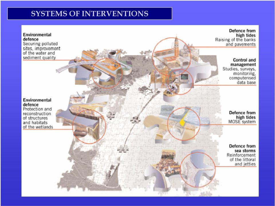
7 SYSTEMS OF INTERVENTIONS
8 Frequency of high tides >= 110 cm

9 Relative see level rise

10

11

12 SYSTEMS OF INTERVENTIONS

13 MOBILE BARRIERS AT THE LAGOON INLETS

14 MOBILE BARRIERS AT THE LAGOON INLETS HOW THE FLOOD GATES WORK DEFENCE AGAINST EXCEPTIONALLY HIGH TIDES: closures of the inlets for tides > 110 cm

15 25% of the Mose flood barrier is under construction 33% financed

16 THE PROJECT - LIDO INLET SITUATION AT JUNE 2006

17 LIDO INLET WORK SITES reinforcement of the south jetty refuge haven new island

18 THE PROJECT - MALAMOCCO INLET SITUATION AT JUNE 2006

19 MALAMOCCO INLET WORK SITES navigation lock the breakwater

20 THE PROJECT - CHIOGGIA INLET SITUATION AT JUNE 2006

21 CHIOGGIA INLET WORK SITES refuge haven and the locks the breakwater the inlet today
22 IMPACT OF FIXED STRUCTURES ON TIDAL FLOW -5 cm average storm surge reduction <10% permanent tidal flow reduction We are monitoring the impact on-going construction works measuring: 1. bathymetric evolution of the sandy bottom at the inlets 2. energy loss through the inlets 3. velocities and tidal flow 4. residual flow and index of river contamination We are building up a DATABASE of monitored data for calibration and validation of hydro-morphological models (hybrid models continuously tuned with experimental data)
23 Inlets evolution inlet cross sections reduction of the inlet cross section tidal flow lagoon basin flow reduction and velocity increase erosion of the sandy bottom at the inlets
24 BATHYMETRIC EVOLUTION OF THE SANDY BOTTOM AT THE INLETS acoustic multibeam survey for monitoring bathymetric changes Chioggia inlet: 1.building of a break-water 2.dredge of the navigation channel Erosions or fills can be part of the construction works (dredge of a new navigation channel, building of a new reef ) or the result of velocity changes due to the ongoing construction works
25 BATHYMETRIC EVOLUTION OF THE SANDY BOTTOM AT THE INLETS evolution of Malamocco inlet from 1999 to October 2006 Evoluzione della barra di foce Progressione dello scavo in bocca Rinforzo testata molo nord Scavo generato dalla protezione del relitto delle ceppe Scavo in prossimità del molo delle ceppe
26 ENERGY LOSS THROUGH THE INLETS 1. Every inlet has different friction coefficient (depending on bottom surface, length of the reefs..) E TOT = E FRICTION + E VORTEX 2. Every inlet has different volumes of vortex and different volumes of moving flow 3. The situation is different at flood and ebb flow
27 ENERGY LOSS THROUGH THE INLETS E TOT = E FRICTION + E VORTEX
28 ENERGY LOSS THROUGH THE INLETS E TOT = E FRICTION + E VORTEX
29 ENERGY LOSS THROUGH THE INLETS CURVE DI CONTROLLO intensity of tidal flow energy loss velocità media sulla sezione in max flusso/riflusso (cm/s) riflusso bocca di LIDO TREPORTI y = 34.5Ln(x) y = -39.6Ln(x) y = -26.2Ln(x) y = 33.4Ln(x) y = 35.7Ln(x) flusso mese di aprile 2004 mese di aprile 2004 mese di settembre - ottobre 2005 mese di novembre 2006 mese di novembre 2006 mese di settembre - ottobre 2005 de [cm] y = -35.8Ln(x)
30 MONITORING VELOCITIES AND TIDAL FLOW TIDAL GAGES in the lagoon in the see
31 MONITORING VELOCITIES AND TIDAL FLOW INSTALLATION OF THE ACOUSTIC FLOW METERS
32 MONITORING VELOCITIES AND TIDAL FLOW Calibration of the acoustic flow meters: -Bathimetric survey -ADCP shape velocity factor Q = k A v -8.5 Q ADCP /A ADCP MALAMOCCO - tutte le campagne di misura di agosto 2001, febbraio 2002 e luglio 2004 y = x R 2 = FLUSSO RIFLUSSO y = x R 2 = V -8,5 m (ADCP)
33 MONITORING VELOCITIES AND TIDAL FLOW misure di VELOCITA DI CORRENTE LIVELLI
34 MONITORING VELOCITIES AND TIDAL FLOW BOCCA DI LIDO
35 MONITORING VELOCITIES AND TIDAL FLOW BOCCA DI MALAMOCCO
36 MONITORING VELOCITIES AND TIDAL FLOW BOCCA DI CHIOGGIA
37 MONITORING VELOCITIES AND TIDAL FLOW BOCCA DI LIDO : experimental installation of a radar tidal gage and waverecorder
38 RESIDUAL FLOW AND INDEX OF RIVER CONTAMINATION Evidence of ground-water richarge into the lagoon RESIDUAL FLOW as a percentage of the tidal flux ( m3/s ) 2.96% %= 2.65% 140 m3/s
39 RESIDUAL FLOW AND INDEX OF RIVER CONTAMINATION First estimation of the grownd-water richarge into the lagoon
40 RESIDUAL FLOW AND INDEX OF RIVER CONTAMINATION installation of salinity probes MICROCAT CTD at the inlets at different depth
41 RESIDUAL FLOW AND INDEX OF RIVER CONTAMINATION Tidal flushing at the lagoon inlets: water recirculation at sea Renewal = V(new) Vin Renewal = Sin,mean - Sout,mean Sin,max-Sout,mean Vin = V(old) + V(new) Recirculation = V(old) =1- Renewal Vin
42 RESIDUAL FLOW AND INDEX OF RIVER CONTAMINATION Tidal flushing at the lagoon inlets: water recirculation at sea data campagna di misura bocca di porto Salinità max in ingresso Salinità minima in riflusso Volume scambiato (m3) Carico di sale in ingresso (t) Carico di sale in uscita (t) Ricambio Ricircolo Efficienza del ricambio rispetto al ricambio ideale in assenza di ricircoli 30-31/10/02 lido /11/02 lido /11/02 malamocco /04/03 malamocco /03/03 chioggia /03/2003 chioggia /07/04 chioggia
43 RESIDUAL FLOW AND INDEX OF RIVER CONTAMINATION
44 AT LIDO INLET
45 CONCLUDING REMARKS The Venice storm surge barriers are a good example of artificial device for flood protection without impacting the sensitive hydromorphological system A monitoring system has been set up for controlling the process In order to improve the reability of the survey system a wi-fi sensor communication system will be tested
SEA LEVEL REAL TIME MONITORING SYSTEM IN THE NORTHEASTERN ITALY
 Workshop on Real-time Transmission and Processing Techniques: Improving the Global Sea Level Observing System s contribution to multihazard warning systems Intergovernmental Oceanographic Commission of
Waterfront Redevelopment: a Strategic factor of Urban Regeneration in Venice
 WaRe Waterfront Regeneration Learning from European best practices for a sustainable urban life Parnü, Estonia, March 30 th April 1 rst 2012 Venice, March 30th 2012 Waterfront Redevelopment: a Strategic
Martin County Coastal GIS Program St Lucie Inlet Planning Tool
 Martin County Coastal GIS Program St Lucie Inlet Planning Tool Alexandra Carvalho, Ph.D., GISP Kathy Fitzpatrick, P.E. Jessica Garland Martin County, Florida Presentation Overview County Coastal Programs
RESTORATION AND ENHANCEMENT OF SOUTHERN CALIFORNIA LAGOONS
 RESTORATION AND ENHANCEMENT OF SOUTHERN CALIFORNIA LAGOONS by Hany Elwany, Ph.D. Scripps Institution of Oceanography Headwaters to Oceans Conference 25 October 2003 CE Ref #03-22 San Diego County Lagoons
The Integration of Hydrographic and Oceanographic Data in a Marine Geographic Information System U.S. Hydro 2015
 The Integration of Hydrographic and Oceanographic Data in a Marine Geographic Information System U.S. Hydro 2015 Karen Hart CARIS USA Oceanography and Hydrography Defined Oceanography: The branch of Earth
Hydraulics Laboratory Experiment Report
 Hydraulics Laboratory Experiment Report Name: Ahmed Essam Mansour Section: "1", Monday 2-5 pm Title: Flow in open channel Date: 13 November-2006 Objectives: Calculate the Chezy and Manning coefficients
Present measurement networks in Italy and future developments
 Present measurement networks in Italy and future developments Renata Archetti DISTART Università di Bologna Luigi Cavaleri ISMAR - CNR Italian Partners involved in Theme 9 Existing National networks for
2.0 BASIC CONCEPTS OF OPEN CHANNEL FLOW MEASUREMENT
 2.0 BASIC CONCEPTS OF OPEN CHANNEL FLOW MEASUREMENT Open channel flow is defined as flow in any channel where the liquid flows with a free surface. Open channel flow is not under pressure; gravity is the
Experiment (13): Flow channel
: Flow channel") Introduction: An open channel is a duct in which the liquid flows with a free surface exposed to atmospheric pressure. Along the length of the duct, the pressure at the surface is therefore constant and
Introduction: An open channel is a duct in which the liquid flows with a free surface exposed to atmospheric pressure. Along the length of the duct, the pressure at the surface is therefore constant and
Waters of the State CALIFORNIA
 Waters of the State CALIFORNIA Waters of the State What are waters of the state? What is California s response to SWANCC and Rapanos? How has the 9 th Circuit responded to SWANCC and Rapanos? Waters of
Alimentatori LED LED drivers
 Alimentatori LED LED drivers ALimentatori LED LED drivers Alimentatori disponibili in diverse potenze e dimensioni con caratteristiche tecniche specifiche per settore di utilizzo Alimentatori per applicazioni
Index-Velocity Rating Development (Calibration) for H-ADCP Real-Time Discharge Monitoring in Open Channels
 for H-ADCP Real-Time Discharge Monitoring in Open Channels") Index-Velocity Rating Development (Calibration) for H-ADCP Real-Time Discharge Monitoring in Open Channels Hening Huang Teledyne RD Instruments, Inc., 14020 Stowe Drive, Poway, CA. 92064, USA (Tel: 858-842-2600,
Index-Velocity Rating Development (Calibration) for H-ADCP Real-Time Discharge Monitoring in Open Channels Hening Huang Teledyne RD Instruments, Inc., 14020 Stowe Drive, Poway, CA. 92064, USA (Tel: 858-842-2600,
Choices and Applications of 2D/3D models for supporting harbour & coastal management
 Choices and Applications of 2D/3D models for supporting harbour & coastal management Terug naar overzicht Rob Uittenbogaard (1,2) (1) WL Delft Hydraulics (2) Delft University of Technology ; J.M. Burgerscentre
CFD Modelling of a Physical Scale Model: assessing model skill. Kristof Verelst 28-11-2014 FHR, Antwerp
 CFD Modelling of a Physical Scale Model: assessing model skill Kristof Verelst 28-11-2014 FHR, Antwerp Introduction Introduction WL_13_61 CFD simulations of hydrodynamics for hydraulic structures (00_085)
4.14 Netherlands. Interactive flood risk map of a part of the province of Gelderland in the Netherlands. Atlas of Flood Maps
 4.14 Netherlands The Netherlands is flood prone for about 60% of its surface. 95 so-called dike-rings protect the polders from being flooded from the North Sea, rivers or lakes. The protection level has
Passenger Terminal Amsterdam
 Fact sheet large cruise ships to Passenger Terminal Amsterdam Port of Amsterdam Amsterdam-IJmond Pilot Organization 2009 Version: November 6 th 2009 This fact sheet provides information on the passage
...Eq(11.6) The energy loss in the jump is dependent on the two depths y 1 and y 2 3 = E =...Eq(11.7)
 The energy loss in the jump is dependent on the two depths y 1 and y 2 3 = E =...Eq(11.7)") . Open Channel Flow Contd.5 Hydraulic Jump A hydraulic jump occurs when water in an open channel is flowing supercritical and is slowed by a deepening of the channel or obstruction in the channel. The
. Open Channel Flow Contd.5 Hydraulic Jump A hydraulic jump occurs when water in an open channel is flowing supercritical and is slowed by a deepening of the channel or obstruction in the channel. The
Bolinas Lagoon Ecosystem Restoration Feasibility Project Marin County Open Space District
 Bolinas Lagoon Ecosystem Restoration Feasibility Project Marin County Open Space District With Funding from the California State Coastal Conservancy & the U.S. Army Corps of Engineers July 2006 Bolinas
Monitoring and control of openchannel flow in irrigation canals
 Monitoring and control of openchannel flow in irrigation canals Xavier Litrico xavier.litrico@cemagref.fr Cemagref, UMR G-EAU, Montpellier Outline Presentation of Cemagref and UMR G-EAU Introduction Research
New Coastal Study for Puerto Rico FIRMs. Paul Weberg, FEMA RII Mat Mampara, Dewberry Jeff Gangai, Dewberry Krista Collier, Baker
 New Coastal Study for Puerto Rico FIRMs Paul Weberg, FEMA RII Mat Mampara, Dewberry Jeff Gangai, Dewberry Krista Collier, Baker September 2007 Project Team FEMA Region II Program Manager Collaboration
Estimation of radial sea currents in the northern Adriatic Sea close to the Venice Lagoon inlets #ID2141
 Estimation of radial sea currents in the northern Adriatic Sea close to the Venice Lagoon inlets #ID2141 ASI CSK Workshop Stefano Zecchetto ISAC-CNR, Uos Padova s.zecchetto@isac.cnr.it Gianfranco Fornaro
The World's Most Interesting Tourist Attractions
 World Canal Conference Milano 2 September 2014 A cultural and tourist water-itinerary on the lagoon of Venice arch. Francesco Calzolaio f.calzolaio@culturnet.net Prolegomena: three ouputs of the European
Catchment Scale Processes and River Restoration. Dr Jenny Mant Jenny@therrc.co.uk. The River Restoration Centre therrc.co.uk
 Catchment Scale Processes and River Restoration Dr Jenny Mant Jenny@therrc.co.uk The River Restoration Centre therrc.co.uk 3 Main Catchment Elements Hydrology Energy associated with the flow of water affects
Particle tracking-modeling of morphologic changes in the Ria de Aveiro
 Journal of Coastal Research SI 64 1560 pg - pg 1564 ICS2011 (Proceedings) Poland ISSN 0749-0208 Particle tracking-modeling of morphologic changes in the Ria de Aveiro A. Picado, P. A. Silva, A. B. Fortunato
PREDICTING THE IMPACT OF CLIMATE CHANGE ON SALINITY INTRUSIONS IN COASTAL SOUTH CAROLINA AND GEORGIA
 PREDICTING THE IMPACT OF CLIMATE CHANGE ON SALINITY INTRUSIONS IN COASTAL SOUTH CAROLINA AND GEORGIA John B. Cook, Edwin A Roehl, and Ruby C Daamen AUTHORS: Advanced Data Mining Intl, 322 Shelton Rd. 322
Field Data Recovery in Tidal System Using Artificial Neural Networks (ANNs)
") Field Data Recovery in Tidal System Using Artificial Neural Networks (ANNs) by Bernard B. Hsieh and Thad C. Pratt PURPOSE: The field data collection program consumes a major portion of a modeling budget.
Field Data Recovery in Tidal System Using Artificial Neural Networks (ANNs) by Bernard B. Hsieh and Thad C. Pratt PURPOSE: The field data collection program consumes a major portion of a modeling budget.
ebb current, the velocity alternately increasing and decreasing without coming to
 Slack water (slack tide): The state of a tidal current when its velocity is near zero, especially the moment when a reversing current changes its direction and its velocity is zero. The term is also applied
MIKE 21 FLOW MODEL HINTS AND RECOMMENDATIONS IN APPLICATIONS WITH SIGNIFICANT FLOODING AND DRYING
 1 MIKE 21 FLOW MODEL HINTS AND RECOMMENDATIONS IN APPLICATIONS WITH SIGNIFICANT FLOODING AND DRYING This note is intended as a general guideline to setting up a standard MIKE 21 model for applications
Exercise (4): Open Channel Flow - Gradually Varied Flow
: Open Channel Flow - Gradually Varied Flow") Exercise 4: Open Channel Flow - Gradually Varied Flow 1 A wide channel consists of three long reaches and has two gates located midway of the first and last reaches. The bed slopes for the three reaches
Exercise 4: Open Channel Flow - Gradually Varied Flow 1 A wide channel consists of three long reaches and has two gates located midway of the first and last reaches. The bed slopes for the three reaches
Facing an Uncertain Future: Increasing Resilience at Marinas and Harbors. Recreational Boating Educational Conference December 11, 2014
 Facing an Uncertain Future: Increasing Resilience at Marinas and Harbors Recreational Boating Educational Conference December 11, 2014 Operators Face Change and Challenges Environmental Conditions Fluctuating
A Case Study Documenting the Dubai Coastal Zone Monitoring Programme An International Example.
 A Case Study Documenting the Dubai Coastal Zone Monitoring Programme An International Example. prepared in the framework of the MESSINA project December 2005 Project part-financed by the European Union
Damage Assessment in a large River Basin The Mekong Experience. Phan Nguyen& Anthony Green Mekong River Commission
 Damage Assessment in a large River Basin The Mekong Experience Phan Nguyen& Anthony Green Mekong River Commission Contents 1. Features and vulnerabilities 2. Influence of Changing Climate 3. Damage Assessment
What is the most obvious difference between pipe flow and open channel flow????????????? (in terms of flow conditions and energy situation)
") OPEN CHANNEL FLOW 1 3 Question What is the most obvious difference between pipe flow and open channel flow????????????? (in terms of flow conditions and energy situation) Typical open channel shapes Figure
OPEN CHANNEL FLOW 1 3 Question What is the most obvious difference between pipe flow and open channel flow????????????? (in terms of flow conditions and energy situation) Typical open channel shapes Figure
Chapter 10. Flow Rate. Flow Rate. Flow Measurements. The velocity of the flow is described at any
 Chapter 10 Flow Measurements Material from Theory and Design for Mechanical Measurements; Figliola, Third Edition Flow Rate Flow rate can be expressed in terms of volume flow rate (volume/time) or mass
MI oceanographic data
 Marine Institute Oceanographic Data SMARTSkills 2013 Postgraduate Workshop Galway, Oct 2013 Kieran Lyons (kieran.lyons@marine.ie) MI oceanographic data Measured Operational metocean time series (weather
Delaware Integrated Marsh Monitor Network: Evaluating sedimentation and sea-levels effects on marsh surface elevation and evolution
 Delaware Integrated Marsh Monitor Network: Evaluating sedimentation and sea-levels effects on marsh surface elevation and evolution Bartholomew D. Wilson Robert Scarborough David B. Carter Donald R. Cahoon
Designing a Basic White Water Canoe/Kayak Course using InfoWorks ICM
 Designing a Basic White Water Canoe/Kayak Course using InfoWorks ICM Adam Cambridge Hydrologist, Sinclair Knight Merz Robert Morden Senior Hydrologist, Sinclair Knight Merz Summary A functional design
The Geosites of the province of Venice
 The Geosites of the province of Venice A. Vitturi, V. Bassan, A. Bondesan, C. Levorato Department of Soil Defence Geological Survey Italian Society of Environmental Geology 1 The data base The data base,
The Coast of Crystal Cove Orange County, California
 The Coast of Crystal Cove Orange County, California by Hany Elwany, Ph.D. Scripps Institution of Oceanography Megan Hamilton, M.Sc. Coastal Environments Robert Robinson Dept. of Parks & Recreation Headwaters
TENNESSEE GAS PIPELINE COMPANY, L.L.C.
 TENNESSEE GAS PIPELINE COMPANY, L.L.C. HYDROLOGIC & HYDRAULIC CALCULATIONS FOR WATERBODIES CROSSED BY CONNECTICUT PIPELINE EXPANSION PROJECT CONNECTICUT LOOP Submitted by: Tennessee Gas Pipeline Company,
Gravir Outer, Isle of Lewis Site and Hydrographic survey report
 Gravir Outer, Isle of Lewis Site and Hydrographic survey report November 2013 The Scottish Salmon Company 8 Melville Crescent Edinburgh EH3 7JA Report No: Issued By: Mathew Laughton Checked By: Mark Edmonds
Design And Construction Of The South San Diego Bay Western Salt Pond Restoration Project. 2012 Headwaters To Ocean Conference
 Design And Construction Of The South San Diego Bay Western Salt Pond Restoration Project 2012 Headwaters To Ocean Conference David Cannon, M.C.E., P.E. President/Principal Engineer Everest International
The extensive monitoring of suspended sediments by means of ultrasound (an ADCP application)
") Best practices for hydropower reservoir sediment management 31May 1June 01, Venice, Italy The extensive monitoring of suspended sediments by means of ultrasound (an ADCP application) Dr. Massimo Guerrero
Best practices for hydropower reservoir sediment management 31May 1June 01, Venice, Italy The extensive monitoring of suspended sediments by means of ultrasound (an ADCP application) Dr. Massimo Guerrero
УДК 528 Nguyen Thanh Le APPLYING MULTIBEAM ECHO-SOUNDER SYSTEM IN MAKING MULTISCALE SEABED TOPOGRAPHY MAP IN VIETNAM
 Новый университет. 2013. 11-12(21-22). ISSN 2221-9552 УДК 528 Nguyen Thanh Le APPLYING MULTIBEAM ECHO-SOUNDER SYSTEM IN MAKING MULTISCALE SEABED TOPOGRAPHY MAP IN VIETNAM Making multiscale seabed topography
SITE INVESTIGATIONS OF THE BEACH EROSION PROBLEM AT MAHO BEACH, ST. MAARTEN
 SITE INVESTIGATIONS OF THE BEACH EROSION PROBLEM AT MAHO BEACH, ST. MAARTEN Performed February 2003 Performed by: Dr. Lee E. Harris, Ph.D., P.E. Associate Professor of Ocean Engineering & Oceanography
Persistent Scatterer Interferometry and Cosmo-SkyMed data in the Piano Straordianario di Telerilevamento Ambientale (PST-A) Salvatore Costabile
 Salvatore Costabile") Persistent Scatterer Interferometry and Cosmo-SkyMed data in the Piano Straordianario di Telerilevamento Ambientale (PST-A) Salvatore Costabile E-GEOS Conference 2012 23-24 May, Rome (Italy) Summary PST-A:
Persistent Scatterer Interferometry and Cosmo-SkyMed data in the Piano Straordianario di Telerilevamento Ambientale (PST-A) Salvatore Costabile E-GEOS Conference 2012 23-24 May, Rome (Italy) Summary PST-A:
3.4 DRAINAGE PLAN. 3.4.1 Characteristics of Existing Drainages. 3.4.2 Master Drainage System. Section 3: Development Plan BUTTERFIELD SPECIFIC PLAN
 3.4 DRAINAGE PLAN This section describes the existing onsite drainage characteristics and improvements proposed within this Specific Plan. Following this description, drainage plan development standards
Flood Mitigation and Management in Bangkok Metropolitan Area
 กร งเทพมหานคร Flood Mitigation and Management in Bangkok Metropolitan Area Present By Mr. Kriangkrai Phamornpol Department of Drainage and Sewerage Bangkok Metropolitan Administration 1 Flood Mitigation
Storm tide is the water level rise during a storm due to the combination of storm surge and the astronomical tide.
 INTRODUCTION TO STORM SURGE Introduction to Storm Surge BOLIVAR PENINSULA IN TEXAS AFTER HURRICANE IKE (2008) What is Storm Surge? Inland Extent Storm surge can penetrate well inland from the coastline.
National Groundwater Conference Canberra, November 2010
 DEVELOPMENT OF AN ADAPTIVE GROUNDWATER MONITORING FRAMEWORK TO INFORM SALINITY MANAGEMENT ACROSS THE VICTORIAN MALLEE REGION National Groundwater Conference Canberra, November 2010 Supported by the National
CEE 370 Fall 2015. Laboratory #3 Open Channel Flow
 CEE 70 Fall 015 Laboratory # Open Channel Flow Objective: The objective of this experiment is to measure the flow of fluid through open channels using a V-notch weir and a hydraulic jump. Introduction:
Storm Drainage Systems 11.9-1
 Storm Drainage Systems 11.9-1 11.9 Gutter Flow Calculations 11.9.1 Introduction Gutter flow calculations are necessary in order to relate the quantity of flow (Q) in the curbed channel to the spread of
Abstract. 1 Introduction
 Assessment of flood risks in polders along the Dutch lakes F. den Heijer* & A.P. de LoofP WL\delft hydraulics ^Ministry of Transport, Public Works and Water Management, Directorate General of Public Works
Dr. Eng. Adamo, List of publications Page 1 of 5
 Dr. Eng. ADAMO Francesco List of publications National and International Journals 1 in press 2 in press 3 in press Adamo F, De Capua C, Filianoti F, Lanzolla A M L, Morello R (in stampa). A Coastal Erosion
Storm tide is the water level rise during a storm due to the combination of storm surge and the astronomical tide.
 INTRODUCTION TO STORM SURGE Introduction to Storm Surge National Hurricane Center Storm Surge Unit BOLIVAR PENINSULA IN TEXAS AFTER HURRICANE IKE (2008) What is Storm Surge? Inland Extent Storm surge can
Consultation on integrating flood defence consents into the Environmental Permitting regime in England and Wales
 www.gov.uk/defra www.wales.gov.uk Consultation on integrating flood defence consents into the Environmental Permitting regime in England and Wales Annex 2; Proposed exclusions Emergencies and licensable
1.0 INTRODUCTION 2.0 SCOPE OF WORK. DATE July 29, 2010 PROJECT No. 09-1436-5008/2000
 DATE July 29, 2010 PROJECT No. 09-1436-5008/2000 TO Geoff Sinnett Ministry of Agriculture and Lands, Crown Land Restoration Branch cc Dawn Flotten FROM Karl Manzer EMAIL kmanzer@golder.com LADYSMITH HARBOUR
AirborneHydroMapping. New possibilities in bathymetric and topographic survey
 AirborneHydroMapping New possibilities in bathymetric and topographic survey AIRBORNE HYDROMAPPING (2008 2011) Layout needs from water engineering side: - Shallow water applications - High point density
Effect of barrages on water level in estuaries
 Indian Journal of Geo-Marine Sciences Vol. 43 (7), July 2014, pp. 1364-1369 Effect of barrages on water level in estuaries S S Chavan *, M D Sawant, Prabhat Chandra & T Nagendra Central Water and Power
Water Management in the Netherlands
 Water Management in the Netherlands Eric Boessenkool Senior Advisor to the Management Board of RIjkswaterstaat Ministry of Infrastructure and the Environment New ministry since end of 2010 Merger of Ministry
FLOW CONDITIONER DESIGN FOR IMPROVING OPEN CHANNEL FLOW MEASUREMENT ACCURACY FROM A SONTEK ARGONAUT-SW
 FLOW CONDITIONER DESIGN FOR IMPROVING OPEN CHANNEL FLOW MEASUREMENT ACCURACY FROM A SONTEK ARGONAUT-SW Daniel J. Howes, P.E. 1 Charles M. Burt, Ph.D., P.E. 2 Brett F. Sanders, Ph.D. 3 ABSTRACT Acoustic
Procedia Environmental Science, Engineering and Management
 Procedia Environmental Science, Engineering and Management http://www.procedia-esem.eu Procedia Environmental Science, Engineering and Management 1 (2014) (1) 59-63 18th International Trade Fair of Material
Scour and Scour Protection
 Design of Maritime Structures Scour and Scour Protection Steven A. Hughes, PhD, PE Coastal and Hydraulics Laboratory US Army Engineer Research and Development Center Waterways Experiment Station 3909 Halls
Numerical Investigation of Angle and Geometric of L-Shape Groin on the Flow and Erosion Regime at River Bends
 World Applied Sciences Journal 15 (2): 279-284, 2011 ISSN 1818-4952 IDOSI Publications, 2011 Numerical Investigation of Angle and Geometric of L-Shape Groin on the Flow and Erosion Regime at River Bends
Assessment of hydropower resources
 Assessment of hydropower resources Oliver Froend Assessment of hydropower resources Relevance of surveys, data assessment and analyses to the success of the project. Required data and field survey. Key
Battery Thermal Management System Design Modeling
 Battery Thermal Management System Design Modeling Gi-Heon Kim, Ph.D Ahmad Pesaran, Ph.D (ahmad_pesaran@nrel.gov) National Renewable Energy Laboratory, Golden, Colorado, U.S.A. EVS October -8, 8, 006 Yokohama,
Automated In-Situ Water Quality Monitoring Report
 Automated In-Situ Water Quality Monitoring Report Issued by the North of Ireland Joint Agency Coastal Monitoring Programme. For further information and data access please visit our website at: www.afbini.gov.uk/coastal-monitoring.htm
CHAPTER 3 STORM DRAINAGE SYSTEMS
 CHAPTER 3 STORM DRAINAGE SYSTEMS 3.7 Storm Drains 3.7.1 Introduction After the tentative locations of inlets, drain pipes, and outfalls with tail-waters have been determined and the inlets sized, the next
Rural Flooding: The Potential Role of Forestry
 Rural Flooding: The Potential Role of Forestry Nadeem Shah, Tom Nisbet, & Huw Thomas Centre for Forestry and Climate Change Structure Background Woodland and Flood Alleviation The Theory. Studies on Woodland
Active and Passive Microwave Remote Sensing
 Active and Passive Microwave Remote Sensing Passive remote sensing system record EMR that was reflected (e.g., blue, green, red, and near IR) or emitted (e.g., thermal IR) from the surface of the Earth.
Section 401 Water Quality Certification
 Section 401 Water Quality Certification Department of Health Environmental Management Division Clean Water Branch Voice: (808) 586-4309 Fax: (808) 586-4352 http://www.hawaii.gov/health/environmental/water/cleanwater/index.html
Head Loss in Pipe Flow ME 123: Mechanical Engineering Laboratory II: Fluids
 Head Loss in Pipe Flow ME 123: Mechanical Engineering Laboratory II: Fluids Dr. J. M. Meyers Dr. D. G. Fletcher Dr. Y. Dubief 1. Introduction Last lab you investigated flow loss in a pipe due to the roughness
Physical Modeling and CFD Simulation of Wave Slamming on Offshore Wind
 Physical Modeling and CFD Simulation of Wave Slamming on Offshore Wind Turbine Structures Arndt Hildebrandt d Franzius-Institute for Hydraulic, Waterways, and Coastal Engineering Slide 0 Overview: Potential
Training programme on flow measurements
 WMO / OMM Autorite du Bassin du Niger Niger-HYCOS and Volta-HYCOS Projects Training programme on flow measurements 2 nd part : Flow measurement techniques Flow measurements and calculations Definitions
Delta development. Teunis Louters Delta Development, the Netherlands
 Delta development Teunis Louters Delta Development, the Netherlands Jasper Fiselier DHV, date 10 June 2011 Active worldwide Over 5.500 employees DHV Group Expertise: - Water - Mobility including Airports
5.0 OVERVIEW OF FLOOD DAMAGE REDUCTION MEASURES
 5.0 OVERVIEW OF FLOOD DAMAGE REDUCTION MEASURES Flood damage reduction consists of two basic techniques structural and non-structural. Structural methods modify the flood and take the flood away from people
The Alternatives of Flood Mitigation in The Downstream Area of Mun River Basin
 The Alternatives of Flood Mitigation in The Downstream Area of Mun River Basin Dr.Phattaporn Mekpruksawong 1, Thana Suwattana 2 and Narong Meepayoong 3 1 Senior Civil Engineer, Office of Project Management,
SECTION 6A STORM DRAIN DESIGN Mar. 2002 S E C T I O N 6A STORM DRAIN - DESIGN
 S E C T I O N 6A STORM DRAIN - DESIGN 6A.l Scope 6A.2 Storm Water Quantity 6A.3 Storm Drain Hydraulics 6A.4 Depths 6A.5 Locations 6A.6 Curved Storm Drains 6A.7 Manholes 6A.8 Catch basins 6A.9 Storm Drain
U.S. Fish and Wildlife Service will invest $15 million for post-sandy cleanup and marsh restoration on Long Island
 For Immediate Release: Wednesday, November 6, 2013 For further information: Michelle Potter, refuge manager, 631/286-0485 ext. 2112, Michelle_Potter@fws.gov Tom Sturm, public affairs specialist, 413/253-8339,
A water quality monitoring network for environmental management of port areas An example from the Port of Venice
 A water quality monitoring network for environmental management of port areas An example from the Port of Venice Nicola Torricella (nicola.torricella@port.venice.it), Marta Citron (marta.citron@port.venice.it)
South Florida Sea Level Rise Projections and Flood Risk Concerns
 South Florida Sea Level Rise Projections and Flood Risk Concerns MIAMI MIAMI Biscayne Bay Glenn B. Landers, P.E. Planning and Policy Division Jacksonville District EVERGLADES NATIONAL PARK USACE Flood
SPOT4 (Take5) Contribution of Sentinel-2 to coast management
 Contribution of Sentinel-2 to coast management") SPOT4 (Take5) Contribution of Sentinel-2 to coast management Take 5 User s Day 2/10/2013 CNES Toulouse V. Lafon A. Robinet L. Barillé D. Bru S. Capo C. Cerisier A. Dehouck D. Doxaran D. Ducrot P. Gernez
SPOT4 (Take5) Contribution of Sentinel-2 to coast management Take 5 User s Day 2/10/2013 CNES Toulouse V. Lafon A. Robinet L. Barillé D. Bru S. Capo C. Cerisier A. Dehouck D. Doxaran D. Ducrot P. Gernez
Water Resource Engineering Modeling Applications Overview
 Water Resource Engineering Modeling Applications Overview Sean L. Smith, P.E. Chief, Water Resources Engineering Branch Jacksonville District January 26-27, 2012 Climate Resilient Infrastructure Workshop
How To Measure The Flow Rate Of The Sacramento River With An Adfm
 Measuring Sacramento River Diversions with ADFM Technology in the Glenn-Colusa Irrigation District Michael A. Metcalf, Ph.D., MGD Technologies Inc., 9815 Carroll Canyon Rd., Suite 2, San Diego, CA 92131,
Chapter 12 - HYDROLOGICAL MEASUREMENTS
 Water Quality Monitoring - A Practical Guide to the Design and Implementation of Freshwater Quality Studies and Monitoring Programmes Edited by Jamie Bartram and Richard Ballance Published on behalf of
Dr. Arzu OLGUN arzu.olgun@mam.gov.tr TUBİTAK Marmara Research Center TURKEY
 Dr. Arzu OLGUN arzu.olgun@mam.gov.tr TUBİTAK Marmara Research Center TURKEY Short information about scope and targets of the ongoing project, Risk Assessment methodologies, GloBallast methodology, Short
6-1 Introduction. 1. Storm drain that does not require pressure testing. 2. Lateral that does not require pressure testing.
 Chapter 6 Storm Drains 6-1 Introduction A storm drain (storm sewer) is a network of pipes that conveys surface drainage from a surface inlet or through a manhole, to an outfall. Storm drains are defined
Stroomatlas sluis van Wintam
 departement Mobiliteit en Openbare Werken Stroomatlas sluis van Wintam Deelrapport 1 NUMERIEK 2D MODEL 119 121 122 123 124 128 122 125 130 12_101 WL Rapporten Vlaamse overheid Stroomatlas sluis van Wintam
What causes Tides? If tidal forces were based only on mass, the Sun should have a tidegenerating
 What are Tides? Tides are very long-period waves that move through the oceans as a result of the gravitational attraction of the Moon and the Sun for the water in the oceans of the Earth. Tides start in
Lecture 4: Streamflow and Stream Gauging
 Lecture 4: Streamflow and Stream Gauging Key Questions 1. What is stream discharge and what controls its magnitude? 2. What is a hydrograph? 3. Where is the velocity highest in a stream? 4. Where is the
 Disaster Prevention Measures in Global-Local Context 4 th World Water Forum Dr. Yoshihiko Yamashita CTI Engineering Co., Ltd Association of Japanese Consulting Engineers Outline of Presentation Up-to to-date
G3-Giornate Giovani GNRAC Quartiere Fieristico di Ferrara, 21 Settembre 2012
 3 SALONE SULLA TUTELA DELLA COSTA COAST PROTECTION EXHIBITION 2 ND EDITION G3-Giornate Giovani GNRAC Quartiere Fieristico di Coastal vulnerability assessment to climate change. CVI Index application to
21. Channel flow III (8.10 8.11)
") 21. Channel flow III (8.10 8.11) 1. Hydraulic jump 2. Non-uniform flow section types 3. Step calculation of water surface 4. Flow measuring in channels 5. Examples E22, E24, and E25 1. Hydraulic jump Occurs
21. Channel flow III (8.10 8.11) 1. Hydraulic jump 2. Non-uniform flow section types 3. Step calculation of water surface 4. Flow measuring in channels 5. Examples E22, E24, and E25 1. Hydraulic jump Occurs
Chapter 9. Steady Flow in Open channels
 Chapter 9 Steady Flow in Open channels Objectives Be able to define uniform open channel flow Solve uniform open channel flow using the Manning Equation 9.1 Uniform Flow in Open Channel Open-channel flows
Background Information: The Mamquam River Floodplain Restoration Project
 Background Information: The Mamquam River Floodplain Restoration Project The Mamquam River Floodplain Restoration project is being undertaken in partnership with the Squamish River Watershed Society, Fisheries
JASPERS Networking Platform
 JASPERS Networking Platform Promoting climate change adaptation, risk prevention and management in the Water Sector UK Emergency Warning System Rachel Brisley, Technical Director & Sophie Dusting, Analyst
STORM DRAINS CHAPTER 7
 CHAPTER 7 Chapter 7 - Storm Drains A storm drain is a drainage system that conveys water or stormwater, consisting of two or more pipes in a series connected by one or more structures. Storm drains collect
Standard Operating Procedures for Flood Preparation and Response
 Standard Operating Procedures for Flood Preparation and Response General Discussion Hurricanes, tropical storms and intense thunderstorms support a conclusion that more severe flooding conditions than
The Dorset Coast Storms 2014 The Impacts, response, communication & building resilience
 GROUNDWATER LANDSLIDES & ROCKFALLS BEACH LOSSES AGRICULTURAL FLOODING BATHING WATERS INFRASTRUCTURE DAMAGE ROAD CLOSURES COASTAL DEFENCES DAMAGE PROPERTY FLOODING SEWER FLOODING The Dorset Coast Storms
Detention Ponds. Detention Ponds. Detention Ponds. Detention Ponds. Detention Ponds. Detention Ponds. CIVL 1112 Detention Ponds - Part 1 1/12
 CIVL 1112 - Part 1 1/12 The water cycle, also known as the hydrologic cycle, describes the continuous movement of water on, above and below the surface of the Earth. The water cycle, also known as the