PPRD SOUTH ASSESSMENT TOOLS REGIONAL RISK ATLAS. Aim of the Atlas is to build a common risk assessment and
|
|
|
- Nathan Atkins
- 8 years ago
- Views:
Transcription
1 PPRD SOUTH ASSESSMENT TOOLS REGIONAL RISK ATLAS Aim of the Atlas is to build a common risk assessment and mapping methodology among the Partner Countries in view to stimulate discussion on shared approaches to disaster risk reduction.

2 FEATURES OF THE PPRD SOUTH ATLAS 1/2 Organized in 3 main information blocks: General country data, Risk data and Disaster data Based on a Web GIS System Detail of information: 1 st administrative level Governorate/Province/Region. Total polygons in the Mediterranean map: 363

3 Features of the PPRD south Atlas 2/2 The Atlas integrates information from international sources on population, census, borders, infrastructures, disasters, development indexes... National data on civil protection capacities are provided by the PPRD South Partner Countries The Atlas utilises a qualitative risk assessment and mapping approach Risk assessment model is being developed in collaboration with Partner Countries and Scientific Institutions (EC JRC, University of Montpellier, UNEP...)

4 RISK ATLAS: COMPONENTS PPRD South Risk Atlas Hazard Exposure Vulnerability

5 PPRD SOUTH QUALITATIVE RISK INDEX Components explaination Hazard: number of events by polygon (earthquakes, floods, landslides, droughts). Data extracted from international databases e.g. Columbia University HOTSPOTS db Exposure: people, property, systems or infrastructures present in the hazard zone subject to potential losses. Data extracted from international databases Vulnerability: calculated compiling three sets of national indicators on: exposure and physical susceptibility, socio- economic fragility and resilience - including data on civil protection capacities

6 COMPONENTS (AREAL COMPETENCE) Hazard Exposure Vulnerability Regional National Georefered Census data PVI Data, (national level), Socioeconomic, Magnitude, info density of resilience, Extension, Infrastructure,ser Time vices,lifeline, susceptibilty National levell Qualitative index Governatorate Georefered Data, Magnitude, Extension, Time Census data (1 st level), info density of Infrastructure, services, lifeline, PVI Socioeconomic, resilience, susceptibilty Sub Nat. level Qualitative index Municipality Georef. Data, Magnitude, Extension, Time, Local data, Maps Census data (local level), localization of Infrastructure, services, lifeline,, cultural heritage, Vulnerability data of building, infrastructures, life line. Georeferred data Quantitative index Historical data International, International, national National, local database information DB
, localization of Infrastructure, services, lifeline,, cultural heritage, Vulnerability data of building, infrastructures,")
7 THE PROCESS E M D A T Disaster Risk Risk Atlas International Data Base National Data Base RISK Hazard Vulnerability Exposure PPRD web gis

8 MODEL OF CALCULATION Ir K I Kh I exp I vul Hazard Exposure Vulnerability Kh= typology of hazard

9 I Kh HAZARD

10 HAZARD

11 I exp EXPOSURE Pop. census Infrastructures Life Line Industries Commerce Services 12 indicators

12 EXPOSURE

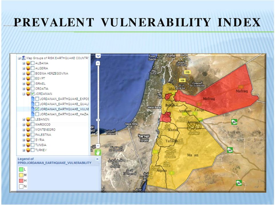
13 PREVALENT VULNERABILITY INDEX I vul C.P. info Exposure and susceptibilitysceptibilit Socio economic fragility Lack of resilience 24+3 indicators The PVI has a holistic approach to vulnerability evaluation, flexible and compatible with other evaluation methods. The PVI main advantage is its ability to disaggregate results and identify priority risk management factors

14 PREVALENT VULNERABILITY INDEX
15 QUALITATIVE RISK I I I Kh exp vul Ir K

16 QUALITATIVE RISK

17 Criticalities and opportunities for action Difficulty to collect data at national level Different data format hampers exchange of data at national and international level Lack of a single international standard for risk assessment and mapping Synergies i with other EU and non-eu programs

18 POSSIBLE USE OF THE ATLAS Risk matrix EUROPEAN COMMISSION WORKING PAPER ON Risk Assessment and Mapping Guidelines for Disaster Management Atlas development process Risk maps Results Catalyses Disaster Risk Reduction policies Opens the way to National Platforms Stimulates research on mitigation

19 Thanks

20 BLOCKS OF THE ATLAS

21 QUALITATIVE AND QUANTITATIVE INDEX
22 INTERNATIONAL DATABASE (HAZARD HYDROGRAPHY ECOREGION) Geological l Province 1999 USGS Geological AGE 1999 USGS Wordl Faults ESRI USFS USGS Earthquake NEIC International Seismic Centre today Columbia University it CHRR, CIESIN (hazard maps: EA, FL,DR,LD, CY, VO, MLT ) EM Dat ( disaster Data Base) CRED Rivers Vmap0 WFP Climate station 2002 NCDC Drainage Vmap0 WFP ECOREGIONS 1999 WWF Conservation Data Base
23 INTERNATIONAL DATABASE (EXPOSITION, MISCELLANEA ) Sub National AD3 Boundaries 2002 FAO ( Geonetwork) Geonames World Gazetteer WFP Global Population Density Estimate 2015 FAO (raster) RWDB2 Administrative Centres & populated places 2003 FAO Population density Geonetwork 2005 FAO (raster) Major Cities 1994 NIMA PPRD Countries: Statistical Offices Statoids Administrative Division of Countries GeoHive Global statistic Contour lines 1997 FAO (Geonetwork) DEM 5 minutes - Africa Europe FAO Coast Buffer distance of Africa 2006 FAO
24 INTERNATIONAL DATABASE (VULNERABILITY: ROADS, PORTS, RAILWAYS, UTILITY, AIRPORTS. MINE,..) Airfield NIMA RWDB2 Airports 2005 FAO RWDB2 Roads 2005 FAO Roads NIMA Utility Lines NIMA Nuclear Plants RWDB2 Ports and Harbours 2005 FAO Ports marine world Database private www Ports marine world Database Railways NIMA RWDB2 Railways 2005 FAO Aqueducts and Canals 1997 FAO Database of African Dams 2009 FAO Oil and Gas Field 1999 USGS - ESRI ORE Deposit 1999 private Mines 1998 USGS
Disaster Risk Assessment:
 Disaster Risk Assessment: Disaster Risk Mapping Dr. Jianping Yan Disaster Risk Assessment Specialist Session Outline Essentials on Risk Mapping Map scale, grid size, aggregation unit Requirements for Risk
HAZARD VULNERABILITY & RISK ASSESSMENT
 Hazard Vulnerability Analysis Purpose and Scope A Hazard Vulnerability Analysis (HVA) evaluates risk associated with a specific hazard. During this analysis, the hazard is evaluated for its probability
WP 7: Build prototype software
 Systemic Seismic Vulnerability and Risk Analysis for Buildings, Lifeline Networks and Infrastructures Safety Gain WP 7: Build prototype software D. Schäfer, VCE A. Bosi, VCE T. Gruber, VCE H. Wenzel, VCE
Building a Spatial Database for Earthquake Risk Assessment and Management in the Caribbean
 Building a Spatial Database for Earthquake Risk Assessment and Management in the Caribbean Jacob Opadeyi and Rehanna Jadoo Department of Geomatics Engineering and Land Management, The University of the
2015 Global Risk Assessment. Sahar Safaie Program Officer, UNISDR Risk Knowledge Section
 2015 Global Risk Assessment Sahar Safaie Program Officer, UNISDR Risk Knowledge Section Outline Global Assessment Report (GAR) evolution Global Risk Assessment for GAR15 Objective Scope Audience/Users
Data Mining and Analysis in ArcGIS Online Joseph Kerski Education Manager Esri jkerski@esri.com Twitter @josephkerski 303-449-7779 x 18237
 Data Mining and Analysis in ArcGIS Online Joseph Kerski Education Manager Esri jkerski@esri.com Twitter @josephkerski 303-449-7779 x 18237 Joseph Kerski Webinar 1 Goals for this workshop 1. Understanding
A Guide to Hazard Identification and Risk Assessment for Public Health Units. Public Health Emergency Preparedness Protocol
 A Guide to Hazard Identification and Risk Assessment for Public Health Units Public Health Emergency Preparedness Protocol Emergency Management Unit Public Health Division Ministry of Health and Long-Term
Formulation of Area Business Continuity and Recovery Programs in Partnership of Public and Private Sector
 Formulation of Area Business Continuity and Recovery Programs in Partnership of Public and Private Sector Dr. Hitoshi BABA Ph.D. Environment and Resource Engineering Senior Advisor, email: Baba.Hitoshi@jica.go.jp
Anchorage All-Hazard Mitigation Plan October 2004
 EXECUTIVE SUMMARY The Municipality of Anchorage (MOA) is vulnerable to a wide range of natural, technological, and human/societal hazards including earthquakes, avalanches, and hazardous material accidents.
Utah State General Records Retention Schedule SCHEDULE 1 GEOSPATIAL DATA SETS
 Utah State General Records Retention Schedule SCHEDULE 1 BIOTA RECORDS (Item 1-26) These are geospatial records that depict wildlife use areas in the state of Utah as determined by wildlife biologists
Drought Risk Assessment:
 Drought Risk Assessment: Mapping the Vulnerability of Agricultural Systems Dr. Jianping Yan Disaster Risk Assessment Specialist Session Outline Understanding the Concept of Vulnerability Mapping the Agricultural
Disaster management challenges in the Danube region related to environmental risks
 MINISTRY OF INTERIOR NATIONAL DIRECTORATE GENERAL FOR DISASTER MANAGEMENT Disaster management challenges in the Danube region related to environmental risks Ágnes Rajacic, project manager National Disaster
How can we defend ourselves from the hazard of Nature in the modern society?
 How can we defend ourselves from the hazard of Nature in the modern society?, University of Bologna President of the EGU Division of Natural Hazards Email: stefano.tinti@unibo.it nh@egu.eu GIFT 2013 Natural
Situation Evaluation of National Risk Assessment. -Tool and Guideline- (Version 1.0)
") Situation Evaluation of National Risk Assessment -Tool and Guideline- (Version 1.0) Global Risk Identification Programme (GRIP) UNDP/BCPR Geneva, Switzerland November 2008 1 Version status and amendments
Situation Evaluation of National Risk Assessment -Tool and Guideline- (Version 1.0) Global Risk Identification Programme (GRIP) UNDP/BCPR Geneva, Switzerland November 2008 1 Version status and amendments
Strategic Considerations on Production and Utilization of Global Mapping Information MEXICO
 Strategic Considerations on Production and Utilization of Global Mapping Information MEXICO 21st Meeting of the ISCGM UN Headquarters, New York, USA, August 2014 Rolando Ocampo Alcántar Vicepresidente
Finance, Mining & Sustainability. The Gamsberg Zinc Project South Africa
 Finance, Mining & Sustainability The Gamsberg Zinc Project South Africa Project Summary Discovered in 1971 Anglo American purchased 33% interest in 1974 and increased interest to 100% in 1998 Feasibility
Contents. Specific and total risk. Definition of risk. How to express risk? Multi-hazard Risk Assessment. Risk types
 Contents Multi-hazard Risk Assessment Cees van Westen United Nations University ITC School for Disaster Geo- Information Management International Institute for Geo-Information Science and Earth Observation
Extreme Events in the Atmosphere
 Cover Extreme Events in the Atmosphere Basic concepts Academic year 2013-2014 ICTP Trieste - Italy Dario B. Giaiotti and Fulvio Stel 1 Outline of the lecture Definition of extreme weather event. It is
PACIFIC CATASTROPHE RISK ASSESSMENT AND FINANCING INITIATIVE
 PACIFIC CATASTROPHE RISK ASSESSMENT AND FINANCING INITIATIVE NIUE SEPTEMBER 11 COUNTRY RISK PROFILE: NIUE Niue is expected to incur, on average,.9 million USD per year in losses due to earthquakes and
Technical #2 Discussion
 Technical #2 Breakdown of teams? Need a scenario to do lifeline work Lifelines and Transportation: ASCE took a lead role in Seattle working with public works and municipalities and DOT. Political topic
District Disaster Risk Management Planning
 District Disaster Risk Management Planning GUIDELINES JULY 2007 National Disaster Management Authority 1. Introduction Notifications for establishment of the District Disaster Management Authorities (DDMAs)
Landforms form an integral part
 Landform classification using GIS by Karsten Drescher, Terralogix Consulting, and Willem de Frey, Ekoinfo Refining existing landform classifications using ESRI s model builder. Landforms form an integral
Keynote 2: What is Landslide Hazard? Inventory Maps, Uncertainty, and an Approach to Meeting Insurance Industry Needs
 Keynote 2: What is Landslide Hazard? Inventory Maps, Uncertainty, and an Approach to Meeting Insurance Industry Needs Jeffrey R Keaton Richard J Roth, Jr Amec Foster Wheeler Los Angeles, USA Consulting
Chapter 6: Mitigation Strategies
 Chapter 6: Mitigation Strategies This section of the Plan describes the most challenging part of any such planning effort the development of a Mitigation Strategy. It is a process of: 1. Setting mitigation
Address and Reduce Flood Risk in Karlstad. Klas Jansson, Director of Planning, Karlstad Municipality, Sweden
 Address and Reduce Flood Risk in Karlstad Klas Jansson, Director of Planning, Karlstad Municipality, Sweden Karlstad Municipality has 82, 000 inhabitants. An increase of 18, 000 would be a total of 100,000
2010 Update to the State of Montana Multi-Hazard Mitigation Plan and Statewide Hazard Assessment 4.0 RISK ASSESSMENT
 4.0 RISK ASSESSMENT The Risk Assessment portion of this document provides a detailed description of the hazards in Montana, an assessment of the State s vulnerability to those hazards, and a basis for
Disaster Risk Reduction UNESCO s contribution to a global challenge
 United Nations International Geoscience Programme Disaster Risk Reduction UNESCO s contribution to a global challenge UNESCO and Disaster Risk Reduction UNESCO operates at the interface between natural
Contribution to Suggestions for Future Commission Priorities Disaster Risk Knowledge Centre
 Contribution to Suggestions for Future Commission Priorities Disaster Risk Knowledge Centre A. Annunziato, D. Al-Khudhairy Natural Disasters trends Factors to be taken into account Rising exposure to disasters
Pacific Catastrophe Risk Assessment and Financing Initiative. Better Information for Smarter Investments
 Pacific Catastrophe Risk Assessment and Financing Initiative Better Information for Smarter Investments Main Outputs Pacific disaster risk assessment Probabilistic assessment of major perils Pacific Risk
Geospatial Software Solutions for the Environment and Natural Resources
 Geospatial Software Solutions for the Environment and Natural Resources Manage and Preserve the Environment and its Natural Resources Our environment and the natural resources it provides play a growing
Multi-Hazard Disaster Risk Assessment (v2)
") Multi-Hazard Disaster Risk Assessment (v2) This How to Note is part of a series of Guidance Notes designed to assist DFID Country Offices in embedding disaster resilience in their country programmes. This
Multi-Hazard Disaster Risk Assessment (v2) This How to Note is part of a series of Guidance Notes designed to assist DFID Country Offices in embedding disaster resilience in their country programmes. This
Protected Areas Resilient to Climate Change, PARCC West Africa
 Communication Strategy (PARCC Activity 4.2) Ver. 1. Protected Areas Resilient to Climate Change, PARCC West Africa 2011 Rapid Screening of Vulnerability Assessment Tools and Framework Proposal Executive
The Use of Geographic Information Systems in Risk Assessment
 The Use of Geographic Information Systems in Risk Assessment With Specific Focus on the RiVAMP Methodology Presented by Nadine Brown August 27, 2012 Climate Studies Group Mona Climate Change Workshop Presentation
P. G. DIPLOMA IN DISASTER RELIEF & REHABILITATION
 P. G. DIPLOMA IN DISASTER RELIEF & REHABILITATION ORDINANCES TITLE: The title of the course shall be P. G. Diploma in Disaster Relief & Rehabilitation OBJECTIVE: The aim of this course is to impart knowledge
National Drought Mitigation Center: Programs and Activities
 National Drought Mitigation Center: Programs and Activities Dr. Donald A. Wilhite, Director National Drought Mitigation Center School of Natural Resources University of Nebraska-Lincoln The Cycle of Disaster
EUROPEAN COMMISSION. Better Regulation "Toolbox" This Toolbox complements the Better Regulation Guideline presented in in SWD(2015) 111
 111") EUROPEAN COMMISSION Better Regulation "Toolbox" This Toolbox complements the Better Regulation Guideline presented in in SWD(2015) 111 It is presented here in the form of a single document and structured
EUROPEAN COMMISSION Better Regulation "Toolbox" This Toolbox complements the Better Regulation Guideline presented in in SWD(2015) 111 It is presented here in the form of a single document and structured
A.P.I.C.E. Common Mediterranean strategy and local practical Actions for the mitigation of Port, Industries and Cities Emissions
 A.P.I.C.E. Common Mediterranean strategy and local practical Actions for the mitigation of Port, Industries and Cities Emissions The study area of Venice ARPA Veneto and Veneto Region Kick off meeting
HIU Common Operating Picture: Health, IDP Locations, USG Assistance
 GIS Support for the Indian Ocean Tsunami Disaster Lee Schwartz Office of the Geographer and Global Issues Bureau of Intelligence and Research U.S. Department of State ESRI Federal Users Conference Washington,
An INSPIRE integrate approach to Environmental Analysis
 An INSPIRE integrate approach to Environmental Analysis C. Cipolloni, C. Iadanza, M. Pantaloni, A. Trigila ISPRA Geological Survey of Italy Main Objectives Implementation of a geo-hazard scenario for different
Preparedness in the Southwest
 Preparedness in the Southwest Risk Assessment and Hazard Vulnerability Developed by The Arizona Center for Public Health Preparedness Cover Art www.azcphp.publichealth.arizona.edu Chapter 1 Importance
Photo & Image Sources
 Photo & Image Sources Module 1 GIS Overview GIS Layers image: MapCruzin.com http://www.mapcruzin.com/what-is-gis.htm 2D Map image: ESRI http://www.esri.com/news/arcnews/winter0607articles/winter0607gifs/p15p1.jpg
Track-Risk-Impact-Policy (TRIP) Modeling for the Agricultural Sector
 Modeling for the Agricultural Sector") Track-Risk-Impact-Policy (TRIP) Modeling for the Agricultural Sector Glenn S. Banaguas Environmental and Climate Change Research Institute De La Salle Araneta University Manila Observatory Ateneo De Manila
Track-Risk-Impact-Policy (TRIP) Modeling for the Agricultural Sector Glenn S. Banaguas Environmental and Climate Change Research Institute De La Salle Araneta University Manila Observatory Ateneo De Manila
Utilizing satellite-based information for disaster risk assessment- why and how?
 Utilizing satellite-based information for disaster risk assessment- why and how? Peeranan Towashiraporn ADPC Session 1, UN International Conference on Space-based Technologies for Disaster Management September
Appendix J Online Questionnaire
 Appendix J Online Questionnaire In accordance with the Paperwork Reduction Act, this questionnaire was approved by the Office of Management and Budget (OMB). The OMB control number and expiration date
Toma Danila Dragos. National Institute for Earth Physics Romania
 Toma Danila Dragos National Institute for Earth Physics Romania Before: evaluate the hazard and risk, be prepared for worst case scenario Natural or antropic disaster After: quickly evaluate the situation
Student Seminar Building climate resilient cities: Exploring theories, practices and prospects 16-17 Feb 2015
 Student Seminar Building climate resilient cities: Exploring theories, practices and prospects 16-17 Feb 2015 Database Management System for coastal cities Rozita Singh, Research Associate, Sustainable
Aligning Natural and Built Infrastructure for
 Aligning Natural and Built Infrastructure for Houston Climate Resilience National Exercise Program (NEP) Houston Climate Change Preparedness & Resilience Workshop Edmond J. Russo, Jr., PhD, PE, D.CE, D.NE,
Urban infrastructure systems such as water and electric power networks
 Assessing the Role of Lifeline Systems in Community Disaster Resilience by Stephanie E. Chang and Christopher Chamberlin Research Objectives The objective of this research is to advance the state-of-the-art
Examples of Eligible Projects. Project Category Description Examples
 Examples of Eligible Projects Public Transit Local Roads, Bridges, and Active Transportation Regional and Local Airports which supports a shared passenger transport system which is available for public
Training Program on Urban Climate Change Resilience 20-22 April, 2015 Database Management System for coastal cities
 Training Program on Urban Climate Change Resilience 20-22 April, 2015 Database Management System for coastal cities Rozita Singh, Research Associate, Sustainable Habitat Division, TERI Why Data? Infrastructure
The correct answers are given below. Some talking points have been added for the teachers use.
 Natural Resources Canada 2011: Lesson Plan Grades 11 and 12 Landslide activity 5b: Landslides in Canada quiz Description: This is an independent study activity for grades 11 and 12. Students will read
Climate resilient infrastructure 2014-2020
 resilient infrastructure 2014-2020 Presented by Claus Kondrup, DG JASPERS Platform Workshop on Adaptation and Risk Management, Brussels, 21-22 October 2014 Territorial climate impacts Geography matters,
Monitoring and evaluating the National Adaptation Programme Infrastructure theme:
 Title Monitoring and evaluating the National Adaptation Programme Infrastructure theme: Design and location of new infrastructure Resilience of infrastructure services a. Energy b. Public water supply
An Initial Assessment of the Impacts of Sea Level Rise to the California Coast
 An Initial Assessment of the Impacts of Sea Level Rise to the California Coast Photo by D. Revell 2/23/08 California Coastal Records Project Dr. David Revell and Matt Heberger, P.E. Dr. Peter Gleick, Bob
Applying GIS in seismic hazard assessment and data integration for disaster management
 Applying GIS in seismic hazard assessment and data integration for disaster management Rumiana Vatseva, Dimcho Solakov, Emilia Tcherkezova, Stela Simeonova, Petya Trifonova National Institute of Geophysics,
Develop hazard mitigation policies and programs designed to reduce the impact of natural and human-caused hazards on people and property.
 6.0 Mitigation Strategy Introduction A mitigation strategy provides participating counties and municipalities in the H-GAC planning area with the basis for action. Based on the findings of the Risk Assessment
Knowledge-based policy making
 INSPIRE Conference 2011, Edinburgh, 27.06 01.07.2011 1 Knowledge-based policy making Prof. Dr Leen Hordijk Director, Institute for Environment and Sustainability Joint Research Centre European Commission
Resolution XII.13. Wetlands and disaster risk reduction
 12 th Meeting of the Conference of the Parties to the Convention on Wetlands (Ramsar, Iran, 1971) Punta del Este, Uruguay, 1-9 June 2015 Resolution XII.13 Wetlands and disaster risk reduction 1. RECALLING
EARTHQUAKE DISASTER GIS AND SPATIAL-TEMPORAL PATTERN OF EARTHQUAKE DISASTERS IN CHINA1
 EARTHQUAKE DISASTER GIS AND SPATIAL-TEMPORAL PATTERN OF EARTHQUAKE DISASTERS IN CHINA1 Mao Feng 1 and Ma Jin feng 2 and Zhou Wen sheng 3 1 Professor,School of Architecture,Tsinghua University, BeiJing.
Crisis Management and Electricity Power Distribution Network Security Zone Determination with Using GIS&RS Technology (Case Study of Neka)
") Crisis Management and Electricity Power Distribution Network Security Zone Determination with Using GIS&RS Technology (Case Study of Neka) Hooshyarkhah B.*, Separi F., Samakoush M.R., Shafi M.R. Mazandarn
Crisis Management and Electricity Power Distribution Network Security Zone Determination with Using GIS&RS Technology (Case Study of Neka) Hooshyarkhah B.*, Separi F., Samakoush M.R., Shafi M.R. Mazandarn
The Caribbean Disaster Mitigation Project: Supporting Sustainable Responses to Natural Hazards
 The Caribbean Disaster Mitigation Project: Supporting Sustainable Responses to Natural Hazards Steven Stichter Caribbean Disaster Mitigation Project (CDMP) Unit of Sustainable Development and Environment
A disaster occurs at the point of contact between social activities and a natural phenomenon of unusual scale.
 Hazard Mapping and Vulnerability Assessment Mr. Toshiaki Udono Senior Project Manager, Kansai Division, PASCO Corporation, Japan Mr. Awadh Kishor Sah Project Manager, Project Implementation Department,
DEVELOPING FLOOD VULNERABILITY MAP FOR NORTH KOREA INTROUDUCTION
 DEVELOPING FLOOD VULNERABILITY MAP FOR NORTH KOREA Soojeong Myeong, Research Fellow Hyun Jung Hong, Researcher Korea Environment Institute Seoul, South Korea 122-706 sjmyeong@yahoo.com hjhong@kei.re.kr
Case Study 3 From vulnerability assessments to public policy in Cartagena, Colombia
 Case Study 3 From vulnerability assessments to public policy in Cartagena, Colombia Claudia Martinez, CDKN Colombia Country Engagement Leader & Green Growth Advisor, Government of Colombia Climate and
Landslide Susceptibility, Hazard and Risk Assessment in Romania The State of the Art
 A Scientific Network for Earthquake, Landslide and Flood Hazard Prevention SciNet NatHazPrev Landslide Susceptibility, Hazard and Risk Assessment in Romania The State of the Art Zoia Prefac Presentation
Development and Recovering From Disaster
 Development and Recovering From Disaster hasan.coban@kalkinma.gov.tr International Symposium on Disaster Economics 3-5 April 2013, Istanbul Natural Disaster in Turkey Other disasters 4% Avalanche 2% Multiple
Oregon Pre-Disaster Mitigation Program Plan Update Training Manual
 FEMA Oregon Pre-Disaster Mitigation Program Plan Update Training Manual Prepared by: Oregon Partnership for Disaster Resilience OPDR FEMA OPDR FEMA OPDR 2010, University of Oregon s Community Service Center
Natural Disasters & Assessing Hazards and Risk. Natural Hazards and Natural Disasters
 Page 1 of 9 EENS 3050 Tulane University Natural Disasters Prof. Stephen A. Nelson Natural Disasters & Assessing Hazards and Risk This page last updated on 19-Aug-2014 Natural Hazards and Natural Disasters
Basics of Sustainability. Environmental Impact Assessments (EIA)
") Basics of Sustainability 8 Environmental Impact Assessments (EIA) 1 Contents Page Aims... 2 Introduction... 3 The Objectives of EIAs... 3 Developments that Require an EIA... 4 Key Stages of an EIA... 6
Basics of Sustainability 8 Environmental Impact Assessments (EIA) 1 Contents Page Aims... 2 Introduction... 3 The Objectives of EIAs... 3 Developments that Require an EIA... 4 Key Stages of an EIA... 6
The Asian Event Dedicated to Homeland and Civil Security
 The Asian Event Dedicated to Homeland and Civil Security In a market with strong needs in security matters, Asia Pacific Homeland Security responds to the expectations of governments, urban local administrations,
PERCENTAGE OF TOTAL POPULATION LIVING IN COASTAL AREAS. Name: Percentage of Total Population Living in Coastal Areas.
 PERCENTAGE OF TOTAL POPULATION LIVING IN COASTAL AREAS Oceans, Seas and Coasts Coastal Zone Core indicator 1. INDICATOR (a) Name: Percentage of Total Population Living in Coastal Areas. (b) Brief Definition:
Contents... 2. Introduction... 3. Risk assessment for crisis preparedness and resilience... 3. Why INFORM?... 4. Using INFORM... 5. Use modes...
 USER GUIDE Contents Contents... 2 Introduction... 3 Risk assessment for crisis preparedness and resilience... 3 Why INFORM?... 4 Using INFORM... 5 Use modes... 5 Prioritisation... 5 Risk profiling... 5
Database Development for Earthquake Risk Assessment. Muhammad Murad Billah Senior GIS Coordinator
 Database Development for Earthquake Risk Assessment Muhammad Murad Billah Senior GIS Coordinator CONTENTS Base Map Development Hazard Mapping - Active Fault Study - Engineering Geological Mapping - Seismic
Developing Capacities for Risk Management and Resilience
 Developing Capacities for Risk Management and Resilience Dr. Kishan Khoday Regional Cluster Leader Climate Change & Resilience UNDP Regional Center in Cairo (kishan.khoday@undp.org) 0 Context As noted
Survey and Mapping Activities in Vietnam *
 UNITED NATIONS E/CONF.100/CRP.1 ECONOMIC AND SOCIAL COUNCIL Eighteenth United Nations Regional Cartographic Conference for Asia and the Pacific Bangkok, 26-29 October 2009 Item 7(a) of the provisional
Predicting Seismic Vulnerable Zones using GIS. Outline of the presentation. Objectives. Risk Mapping Overview Factor Maps. Three levels of Zonation
 Predicting Seismic Vulnerable Zones using GIS by K.S.A. Dinesh Kumar Research Scholar, Anna University & Lecturer in Civil Engineering Dept. National Institute of Technical Teachers Training & Research
DISASTERS & EMERGENCIES
 DISASTERS & EMERGENCIES DEFINITIONS Training Package WHO/EHA Panafrican Emergency Training Centre, Addis Ababa Updated March 2002 by EHA 1 WORLDWIDE Number of People Affected by Disasters Million 400 350
USING GEO-DATA CORPORATELY ON THE RESPONSE PHASE OF EMERGENCY MANAGEMENT
 USING GEO-DATA CORPORATELY ON THE RESPONSE PHASE OF EMERGENCY MANAGEMENT E. Demir Ozbek a,b *, S. Ates a,b, A.C. Aydinoglu c a 3D Geoinformation, Delft University of Technology, Delft, The Netherlands-
A Geospatial Solution for Minimizing Risk. Pipeline Hazard Categorization
 A Geospatial Solution for Minimizing Risk Pipeline Hazard Categorization 1 Agenda 1. At stake: corporate value and reputation 2. Contributing Pipeline Segments: a building block for risk prioritization
EMERGENCY MANAGEMENT AGAINST THE NATURAL DISASTERS OF TURKEY: MITIGATION, RESPONSE AND RECOVERY ISSUES
 3 rd Roundtable Meeting on Disaster Management 19 November 2014; JCSE HQ Auditorium EMERGENCY MANAGEMENT AGAINST THE NATURAL DISASTERS OF TURKEY: MITIGATION, RESPONSE AND RECOVERY ISSUES Beyza TASKIN (PhD)
ENVIRONMENTAL IMPACT ASSESSMENT PROCESS PROPOSED PHASE 2 EXPANSION OF THE TRANSNET IRON ORE HANDLING FACILITY, SALDANHA
 ENVIRONMENTAL IMPACT ASSESSMENT PROCESS PROPOSED PHASE 2 EXPANSION OF THE TRANSNET IRON ORE HANDLING FACILITY, SALDANHA BACKGROUND INFORMATION DOCUMENT 1 BACKGROUND Transnet Limited s (Transnet) existing
Operational methodology to assess flood damages in Europe
 IIASA-DPRI 2008 Operational methodology to assess flood damages in Europe Contributors: Nicola Lugeri, Carlo Lavalle, Elisabetta Genovese 1 Focus of ADAM work on extremes Types Floods, Heat-wave, Drought
Chattichai WAISURASINGHA 1*, Prinya CHINDAPRASIRT 1, Winai SRI-AMPORN 1 and Sinee CHUANGCHAM 2
 The Utilization of Geographic Information Systems and Multi-Criteria Decision Making with Local Community Participation for Selection of Site for Micro Hydropower Project: A Case Study of Chi River Basin,
Town of Warwick, Village of Florida, Village of Greenwood Lake and Village of Warwick MULTI JURISIDICTIONAL, MULTI HAZARD MITIGATION PLAN DRAFT
 Town of Warwick, Village of Florida, Village of Greenwood Lake and Village of Warwick MULTI JURISIDICTIONAL, MULTI HAZARD MITIGATION PLAN DRAFT Appendix B Historical Hazard Documentation Rev #0 May 2013
D 8.2 DELIVERABLE PROJECT INFORMATION
 D 8.2 DELIVERABLE PROJECT INFORMATION Project Title: Acronym: Systemic Seismic Vulnerability and Risk Analysis for Buildings, Lifeline Networks and Infrastructures Safety Gain SYNER-G Project N : 244061
18-22 January 2005, Kobe, Hyogo, Japan. Building the Resilience of Nations and Communities to Disasters. www.unisdr.org/wcdr
 World Conference on Disaster Reduction 18-22 January 2005, Kobe, Hyogo, Japan Hyogo Framework for Action 2005-2015: Building the Resilience of Nations and Communities to Disasters * www.unisdr.org/wcdr
Africa Adaptation Programme
 Africa Adaptation Programme Examples of experiences, challenges and success stories from implemented and ongoing projects and initiatives on climate observations Joseph D. Intsiful AAP Data and information
RISK AND RESILIENCE $58,000,000 +$38,000,000 / 190.0%
 RISK AND RESILIENCE $58,000,000 +$38,000,000 / 190.0% Overview The economic competiveness and societal well-being of the United States depend on the affordability, availability, quality, and reliability
HANDBOOK FOR CONDUCTING A GIS-BASED HAZARDS ASSESSMENT AT THE COUNTY LEVEL
 HANDBOOK FOR CONDUCTING A GIS-BASED HAZARDS ASSESSMENT AT THE COUNTY LEVEL by Susan L. Cutter, Jerry T. Mitchell, and Michael S. Scott Hazards Research Lab, Department of Geography University of South
The Army Corps of Engineers and the Flood Risk Challenge
 The Army Corps of Engineers and the Flood Risk Challenge Presentation to Association of State Flood Plain Managers Steven L. Stockton, P.E. Director of Civil Works June 12, 2013 US Army Corps of Engineers
ART Vulnerability and Risk Assessment Report September 2012 Appendix C. ART GIS Exposure Analysis
 Adapting to Rising Tides GIS Exposure Analysis The aim of this appendix is to familiarize the reader with the data and methodology that was used to conduct an analysis of shoreline and community asset
PRESENTERS: BACHELOR OF ARTS- PSYCHOLOGY
 KIBET J. NELLY PRESENTERS: MAGAI N. DORCAS BACHELOR OF ARTS- PSYCHOLOGY DISASTER? A serious disruption of the functioning of a community or society causing widespread human, material, economic or environmental
Geothermal. . To reduce the CO 2 emissions a lot of effort is put in the development of large scale application of sustainable energy.
 Geothermal Energy With increasing fossil fuel prices, geothermal energy is an attractive alternative energy source for district heating and industrial heating. In recent years the use of geothermal energy
Information architecture (IA)
") Information architecture (IA) Global Risk Identification Program H. Dao, 24 May 06 Global Risk Identification Program 1 Context Risk identification for taking concrete mitigation actions (decision making)
Information architecture (IA) Global Risk Identification Program H. Dao, 24 May 06 Global Risk Identification Program 1 Context Risk identification for taking concrete mitigation actions (decision making)
Building Caribbean GeoNode Platform in Support of Climate Risk Management Jacob Opadeyi, PhD
 Building Caribbean GeoNode Platform in Support of Climate Risk Management Jacob Opadeyi, PhD Our Highly Vulnerable Region Housing developments on drainage channels and steep slopes Unapproved development
UNISDR - Global Risk Assessment: Towards a high-performance environment
 1 UNISDR - Global Risk Assessment: Towards a high-performance environment WCDRR, Sendai 15 March, 2015 Sahar Safaie, Julio Serje Global Assessment Report Team United Nations Office for Disaster Risk Reduction
7th Framework Programme Theme 6 Environment (including climate change)
") 7th Framework Programme Theme 6 Environment (including climate change) «Environnement» et «Énergie» Programme D. Deybe DG RTD Environment Directorate 1 Cooperation Collaborative Research Ten themes 1.
7th Framework Programme Theme 6 Environment (including climate change) «Environnement» et «Énergie» Programme D. Deybe DG RTD Environment Directorate 1 Cooperation Collaborative Research Ten themes 1.
Homeland Security Infrastructure Program HSIP Gold 2012 September 2012
 Homeland Security Infrastructure Program HSIP Gold 2012 September 2012 George Thomas, Chief, Content & Knowledge Management Division (PDC) IWG-Readiness, Response & Recovery (IWG-R3) George.J.Thomass@nga.mil,
Rafi Ahmad & Parris Lyew-Ayee
 Challenges with Spatial Information in the Caribbean Rafi Ahmad & Parris Lyew-Ayee Mona GeoInformatics Institute The University of the West Indies at Mona, Jamaica Challenges associated with: Data availability
SESSION 8: GEOGRAPHIC INFORMATION SYSTEMS AND MAP PROJECTIONS
 SESSION 8: GEOGRAPHIC INFORMATION SYSTEMS AND MAP PROJECTIONS KEY CONCEPTS: In this session we will look at: Geographic information systems and Map projections. Content that needs to be covered for examination