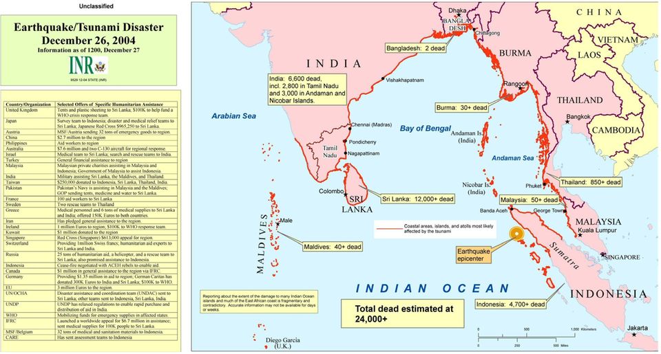
HIU Common Operating Picture: Health, IDP Locations, USG Assistance
|
|
|
- Nathaniel Holmes
- 7 years ago
- Views:
Transcription
1 GIS Support for the Indian Ocean Tsunami Disaster Lee Schwartz Office of the Geographer and Global Issues Bureau of Intelligence and Research U.S. Department of State ESRI Federal Users Conference Washington, D.C. February 1, 2005

2
3

4 HIU Common Operating Picture: Health, IDP Locations, USG Assistance

5 USGS Response to Dec. 26 Tsunami USGS Global Seismic Network (GSN) flashed seismic data minutes after quake to NOAA s Pacific Tsunami Warning Center (PTWC) and other GSN members. USGS National Earthquake Information Center (NEIC) issued first alert of an 8.5 earthquake in the Indian Ocean. s/Pager notifications to 25,000+ recipients, incl. those in affected countries. EROS Data Center on 12/27 began acquiring LandSat, ASTER, ALI, and Hyperion imagery [NASA EOS: Terra, SRTM]. Provided support under the International Charter: Space and Major Disasters (India and Sri Lanka activated the Charter). 12/28 began puchasing/licensing/posting of commercial, public domain, and USG GIS/RS data and derived products on public domain ftp site and USGS web site. NEIC by 12/29 produced Shake Maps (showing location/intensity of shaking) and PAGER maps (estimating numbers affected by strong ground shaking). Preparation of draft science plan for reconstruction and development.
![EROS Data Center on 12/27 began acquiring LandSat, ASTER, ALI, and Hyperion imagery [NASA EOS: Terra, SRTM].](/docs-images/48/19276678/images/page_5.jpg "Provided support under the International Charter: Space and Major Disasters (India and Sri Lanka activated the Charter).")
6

7 NOAA Tsunami Response Immediate Assistance: Within minutes following an alarm signaling a strong earthquake, NOAA s Pacific Tsunami Warning Center in Hawaii issued a bulletin to Pacific governments indicating a magnitude 8.0 earthquake (later upgraded to 9.0) had occurred off the west coast of Northern Sumatra, Indonesia. Lead agency for International Charter: Space and Major Disasters, to coordinate for dissemination remotely sensed info and derived products. Current Assistance: Providing updated weather information to support recovery efforts.

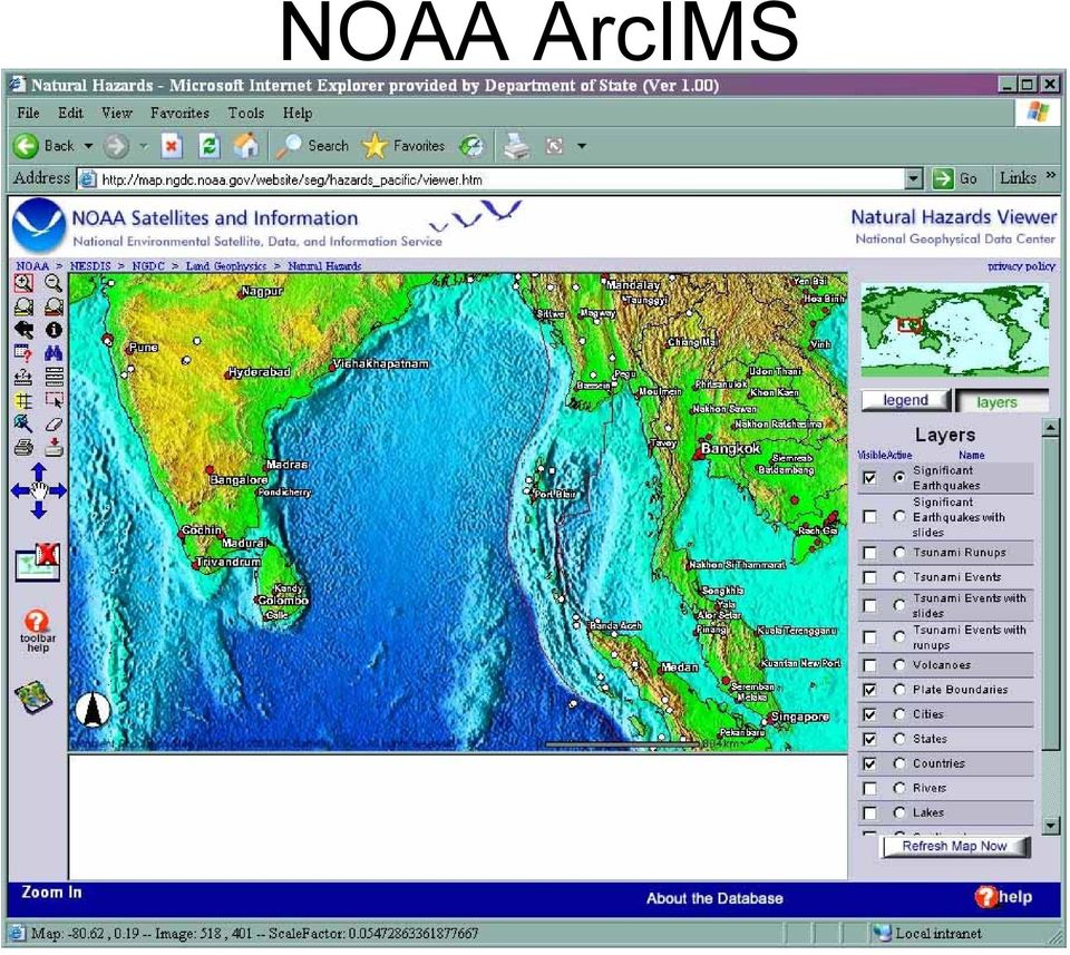
8 NOAA ArcIMS
9 Planned NOAA Tsunami Assistance On January 14, 2005, the U.S. announced plans to expand the U.S. tsunami detection and warning capabilities as a contribution of the Global Earth Observation System of Systems, or GEOSS the international effort to develop a comprehensive, sustained and integrated Earth observation system. NOAA will expand the deployment of its Deep-ocean Assessment and Reporting of Tsunamis (DART) buoy system to include the Indian Ocean, and work to enhance the dissemination of future tsunami warnings to potentially effected countries.

10 National Geospatial-Intelligence Agency (NGA) Tsunami Disaster Support Image City Maps produced SRTM 1 Elevation Data with void fill produced Controlled Imagery Base produced VMAP 1 and DFAD0 provided CADRG Raster Maps provided and produced Aeronautical information updates Over 100 GB of Commercial Imagery purchased (CSIL; PDC)
 http:osis.nga.")
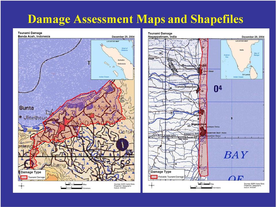
11 Damage Assessment Maps and Shapefiles
12 Commercial Imagery Applications

13 Office of U.S. Foreign Disaster Assistance FUNDING: Humanitarian Information Center (HIC) in Sumatra, and UN OCHA/Field Information Support Unit (oversees HICs & chairs Geographic Information Support Team -- UN agencies, donors, others). Cooperative Agreement with University of Georgia s Institute of Technology Outreach Services (ITOS) to maintain GIST Data Repository and provide processing, collection, and other services. Seconded a staff member to HIC in Sumatra. Agreement with USGS/EROS Data Center to obtain, process, analyze imagery. PARTNERSHIPS: Strategic input for data coordination effort within the humanitarian community via the GIST. Work with NGA to obtain/distribute 1:50,000 scanned Indonesian maps for NW Sumatra. Arranged with partners to provide vector base data, some created by extracting features off of large-scale Indonesian maps. Distributed LandSat and VMAP1 data provided by USGS/EDC. Arranged for and distributed two sets of damage area polygons and maps for the region, one developed by USGS/EDC using change detection techniques on LandSat data. Arranged for and received IKONOS, QuickBird, and OrbView imagery from NGA. Worked with USGS/EDC to provide distribution in appropriate formats.
 to maintain GIST Data Repository and provide processing, collection, and other services.")
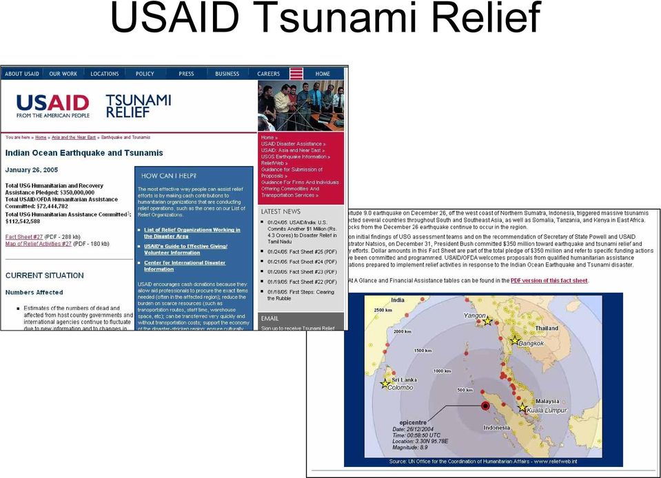
14 USAID Tsunami Relief
15 NGA GEOINT Support at the Department of State, INR/GGI Damage Assessment Maps and Shapefiles INR/HIU, DoS Tsunami Task Force, USAID/OFDA Aceh GIS Database INR/HIU, INR/GIU, USAID/OFDA, UN/OCHA - HIC Mission Specific Transportation Data INR/HIU, INR/GIU, USAID/OFDA, INR/HIU, GA support to the INR/GIU Atlas Project USAID/OFDA, INR/HIU, DoS Tsunami Task Force, United Nations

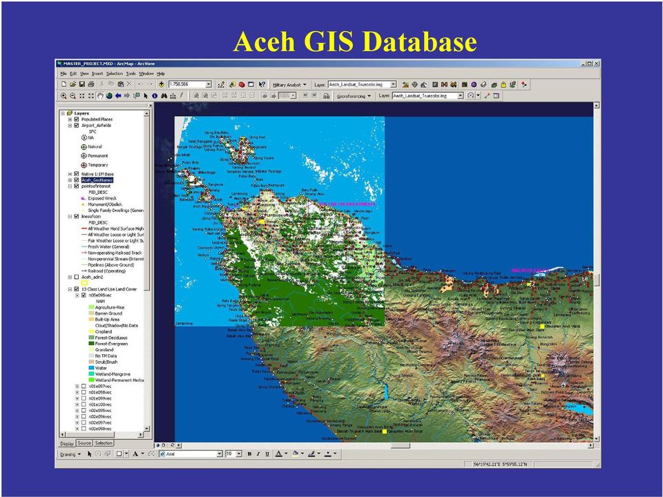
16 Aceh GIS Database
17 State INR/GGI Aceh Coastal Atlas

18

19 Specific efforts were required to compile good data. Repaired holes in SRTM level 1. Determined the best 2 nd Order Administrative boundaries from more than 10 different sources. Added attributes to the geonames layer to distinguish administrative capitals.

20 Tsunami Humanitarian Information Sharing (THIS) Interagency Working Group Information about GIS services and availability of imagery was was disseminated through formal Dept. of State diplomatic channels (cable) to USG embassies around the world.
 to USG embassies around")
21
22
23 PDC GIS Efforts Supporting Sumatra Tsunami Geospatial Data Processing and Distribution Obtained and processed high-resolution satellite imagery from NGA; coordinating processing with USGS EDC, Mercy Corps and other organizations. Launched ArcIMS-based "Indian Ocean Tsunami Geospatial Information Service and the corresponding Internet-based Map Viewer. ( ESRI provided consultative services to support high-volume/high-availability site requirements. Providing on-line access to the GIS data via the Internet map service, the viewer, and the ftp site at Maui High Performance Computing Center (MHPCC) Non-mil. org with direct SkyMedia/CSIL access Supporting USG Inter-Agencies and the international communities of interest In-country GIS Data Collection & Usage - Used to characterize conditions in the disaster zone for USPACOM Joint Task Force (JTF). Illustrated the before/after effects and computed geographical extent of damage. Portrayed high population densities for Humanitarian Assistance target areas. Used in identification of damaged areas to target P-3 flyovers (to acquire higher resolution imagery of downed bridges, roads, etc. for determining main supply routes, hospital locations, helicopter landing zones, refuge camps.) Supported data collection efforts in Thailand and Indonesia Earthquake Notification Solution Short term notification solution to Southeast Asian disaster managers for possible large aftershocks and earthquakes in the Indian Ocean
24 eroom Collaborative Space
25 Groove Collaborative Space for the Field Groove is ideally suited for collaboration and information sharing in austere environments. It is not web-based, is based on peer-to-peer connectivity, and users can access Groove spaces on their laptops without internet connectivity.
26 HIU Website
27 HIC (Humanitarian Information Centre for Sumatra)
28 The real story: role of commercial imagery, vendors, private concerns
29 German Aerospace Center: Center For Satellite-Based Crisis Information
30
31
32
33 Lessons Learned working with geospatial data Nothing simple, automated, or clean about compiling the best data available. Phone calls, research, and tedious tweaking of data. Oftentimes, data with better attributes is better than more-detailed data with little or no attributes. Available data doesn t mean you end up with a good cartographic product. Much of the data needs to be edited, orthorectified, etc. (e.g. -different shorelines). Sources were compiled from the United Nations, Global Forest Watch, NGA, State Department Map Annex, Dartmouth Flood Observatory, World Bank, and NASA. Some of the best data came non-government sources (e.g. Global Forest Watch, Dartmouth). Networking with colleagues across different agencies, commercial vendors, businesses, and NGOs are necessary in the compilation of good datasets.
34 Lessons Learned applying geospatial information Extent of Disaster/Footprint Populations at Risk Field-driven requirements GIS vs. IM and IT Appropriate Technology Relief vs. Rehabilitation
Assessment of Impact of the December 26, 2004 Tsunami In Aceh Province Indonesia
 Assessment of Impact of the December 26, 2004 Tsunami In Aceh Province Indonesia Jay H. Samek, David L. Skole, and Walter Chomentowski December 30, 2004 Center for Global Change and Earth Observations
Hazard Detection, Monitoring, Modeling, Assessment and Warning in the Asia Pacific Region
 Chengdu Forum on UN-GGIM Global Map for Sustainable Development: Development and Applications in Urban Hazard Mapping Chengdu, Sichuan Province, China 15-17 Oct 2013 Hazard Detection, Monitoring, Modeling,
Why Should You Use Sahana Eden?
 Open Source Disaster Management Software Platform Why Should You Use Sahana Eden? Sahana Eden is an open source software platform which has been built specifically to help in Disaster Management. It is
Enterprise GIS Solutions to GIS Data Dissemination
 Enterprise GIS Solutions to GIS Data Dissemination ESRI International User Conference July 13 17, 2009 Wendy M. Turner Senior GIS Engineer & Program Manager Freedom Consulting Group, LLC Building the Enterprise
1.0 Business Case. 2.0 Current Circumstances. 3.0 Proposed Solution
 Proposal Plan for Geographic Information System (GIS) Capability for the Department of State Human Resources Knowledge Center - C. Christian (IRM/BPC/eDiP), R. Harford (HR/EX/SDD), B. Van Pay and D. Smith
GIS Data Conversion. GIS maps are digital not analog. Getting the Map into the Computer
 Getting the Map into the Computer Getting the Map into the Computer Getting Started with Geographic Information Systems Chapter 4 4.1 Analog-to-Digital Maps 4.2 Finding Existing Map Data 4.3 Digitizing
Editing Strategies for Enterprise Geodatabase
 Federal GIS Conference February 9 10, 2015 Washington, DC Editing Strategies for Enterprise Geodatabase Ty Fabling Esri Solution Engineer A Complete Platform Enabling GIS Everywhere Desktop Web Device
U.S. Indian Ocean Tsunami Warning System (IOTWS) Program Integrated Program Work Plan 2005-2007 APPENDIX B PERFORMANCE MANAGEMENT PLAN
 Program Integrated Program Work Plan 2005-2007 APPENDIX B PERFORMANCE MANAGEMENT PLAN") U.S. Indian Ocean Tsunami Warning System (IOTWS) Program Integrated Program Work Plan 2005-2007 APPENDIX B PERFORMANCE MANAGEMENT PLAN February 2008 Version 2.1 PMP February 2007, Version 2.1 CONTENTS
U.S. Indian Ocean Tsunami Warning System (IOTWS) Program Integrated Program Work Plan 2005-2007 APPENDIX B PERFORMANCE MANAGEMENT PLAN February 2008 Version 2.1 PMP February 2007, Version 2.1 CONTENTS
PACIFIC TSUNAMI: CONTINUING RESEARCH AND FORMATION OF A MUSEUM EXHIBIT
 PACIFIC TSUNAMI: CONTINUING RESEARCH AND FORMATION OF A MUSEUM EXHIBIT Melissa Ann Meiner Geology/Marine Science Department University of Hawai i at Hilo Hilo, HI 96720 ABSTRACT The Sumatran tsunami was
Homeland Security Infrastructure Program HSIP Gold 2012 September 2012
 Homeland Security Infrastructure Program HSIP Gold 2012 September 2012 George Thomas, Chief, Content & Knowledge Management Division (PDC) IWG-Readiness, Response & Recovery (IWG-R3) George.J.Thomass@nga.mil,
Frequently Asked Questions: Wetlands Mapper
 Frequently Asked Questions: Wetlands Mapper December 2015 Mapper Content and Display How does the public access the new Mapper? The Wetlands Mapper can be found at: http://www.fws.gov/wetlands/ Does the
A CONCEPT OUTLINE ESTABLISHING THE
 Updated 13 November 2009 A CONCEPT OUTLINE ESTABLISHING THE Philippine GIS Data Clearinghouse (PhilGIS) www.philgis.org Prepared by Al Tongco, Ph.D. Stillwater, Oklahoma, U.S.A. al_tongco@yahoo.com Introduction
Visualize your World. Democratization i of Geographic Data
 Visualize your World Democratization i of Geographic Data Session Agenda Google GEO Solutions - More than just a Map Enabling our Government Customers- Examples Summary & Invite to Learn More About Google
Mapping Mashup/Data Integration Development Resources
 Mapping Mashup/Data Integration Development Resources David Hart GIS Specialist University of Wisconsin Sea Grant Institute October 6, 2008 Virtual Globes A virtual globe is a 3D software model or representation
DISASTER DISASTER MANAGEMENT CRISIS INFORMATICS GIS IN DIFFEERENT STAGES OF DISASTER MANAGEMENT
 APPLICATION OF GIS AND REMOTE SENSING IN DISASTER PRONE AREAS: A CASE STUDY IN COASTAL KERALA DISASTER Disaster is an unpleasant event than occurs with little or no warning which results in economic disruption,
The 2014 International Training Workshop on Natural Disaster Reduction
 The 2014 International Training Workshop on Natural Disaster Reduction 27 October - 31 October, 2014; Taipei, Taiwan The 10th International Training Workshop on Natural Disaster Reduction was convened
Spatial Information for assessing Land Issues in Disaster Risk Management
 Spatial Information for assessing Land Issues in Disaster Risk Management Prof.dr. Jaap Zevenbergen, Dr. Norman Kerle, Dr. Arbind Tuladhar FAO/FIG Cooperation on land and disaster based on a report funded
Mapping Mashup/Data Integration Development Resources Teaching with Google Earth and Google Ocean Stone Lab August 13, 2010
 Mapping Mashup/Data Integration Development Resources Teaching with Google Earth and Google Ocean Stone Lab August 13, 2010 David Hart GIS Specialist University of Wisconsin Sea Grant Institute Virtual
NOAA ADVISORY COMMITTEE FOR COMMERCIAL REMOTE SENSING (ACCRES) OPEN SESSION MEETING SUMMARY March 10, 2006
 OPEN SESSION MEETING SUMMARY March 10, 2006") NOAA ADVISORY COMMITTEE FOR COMMERCIAL REMOTE SENSING (ACCRES) OPEN SESSION MEETING SUMMARY March 10, 2006 Open Session The NOAA Advisory Committee for Commercial Remote Sensing (ACCRES) was convened on
NOAA ADVISORY COMMITTEE FOR COMMERCIAL REMOTE SENSING (ACCRES) OPEN SESSION MEETING SUMMARY March 10, 2006 Open Session The NOAA Advisory Committee for Commercial Remote Sensing (ACCRES) was convened on
German Earth Observation Systems and Programs Capacities for nation building
 German Earth Observation Systems and Programs Capacities for nation building German Aerospace Center, DLR, Earth Observation Center, EOC German Remote Sensing Data Center, DFD Gunter Schreier Deputy Director
U.S. COMMERCIAL REMOTE SENSING POLICY. April 25, 2003 FACT SHEET
 U.S. COMMERCIAL REMOTE SENSING POLICY April 25, 2003 FACT SHEET The President authorized a new national policy on April 25, 2003 that establishes guidance and implementation actions for commercial remote
Submission by the United States of America to the UN Framework Convention on Climate Change Communication of U.S. Adaptation Priorities May 29, 2015
 Submission by the United States of America to the UN Framework Convention on Climate Change Communication of U.S. Adaptation Priorities May 29, 2015 Adaptation is a challenge for all Parties. In addition
Improved Warnings for Natural Hazards: A Prototype System for Southern California
 Improved Warnings for Natural Hazards: A Prototype System for Southern California Yehuda Bock Research Geodesist Scripps Institution of Oceanography University of California San Diego, La Jolla, Calif.
Indonesian National Network on Disaster Resource Partnership (DRP)
") 2011/EPWG/WKSP/021 Session 4 Indonesian National Network on Disaster Resource Partnership (DRP) Submitted by: Indonesia Workshop on Private Sector Emergency Preparedness Sendai, Japan 1-3 August 2011 Presentation
2011/EPWG/WKSP/021 Session 4 Indonesian National Network on Disaster Resource Partnership (DRP) Submitted by: Indonesia Workshop on Private Sector Emergency Preparedness Sendai, Japan 1-3 August 2011 Presentation
Bhuvan. Indian Earth Observation Visualization. Indian Space Research Organisation. http://bhuvan.nrsc.gov.in. Multi Resolution. Societal Applications
 Multi Resolution Bhuvan Societal Applications Indian Earth Observation Visualization http://bhuvan.nrsc.gov.in 3D Geographic Models Seamless Fly Through Indian Space Research Organisation Thematic Vectors
A GIS helps you answer questions and solve problems by looking at your data in a way that is quickly understood and easily shared.
 A Geographic Information System (GIS) integrates hardware, software, and data for capturing, managing, analyzing, and displaying all forms of geographically referenced information. GIS allows us to view,
Application of Google Earth for flood disaster monitoring in 3D-GIS
 Disaster Management and Human Health Risk II 271 Application of Google Earth for flood disaster monitoring in 3D-GIS M. Mori & Y. L. Chan Department of Information and Computer Science, Kinki University,
Monitoring and Evaluating Post Disaster Recovery Using High Resolution Satellite Imagery
 Monitoring and Evaluating Post Disaster Recovery Using High Resolution Satellite Imagery Daniel Brown, Keiko Saito and Torwong Chenvidyakarn Department of Architecture, Cambridge University Cambridge,
Implementing Marine SDI Through Capacity Building
 Implementing Marine SDI Through Capacity Building A TopoBathy Database for Mozambique NIOHC Colombo, 20 th 23 rd March 2012 Fredericton Canada Heeswijk The Netherlands Washington DC United States Adelaide
Emergency Support Function #9 Search and Rescue Annex INTRODUCTION. Purpose. Scope. ESF Coordinator: Support Agencies: Primary Agencies:
 ESF Coordinator: Homeland Security/ Federal Emergency Management Agency Primary Agencies: Homeland Security/ Federal Emergency Management Agency Homeland Security/ U.S. Coast Guard the Interior/National
Remote Sensing Applications in Support of Sustainable Development and Disaster Management by DLR Current Activities
 Remote Sensing Applications in Support of Sustainable Development and Disaster Management by DLR Current Activities Dr. Günter Strunz German Aerospace Center (DLR) German Remote Sensing Data Center 43rd
Monitoring and Evaluating Post-Disaster Recovery Using High- Resolution Satellite Imagery
 Monitoring and Evaluating Post-Disaster Recovery Using High- Resolution Satellite Imagery Daniel Brown, Keiko Saito and Torwong Chenvidyakarn Department of Architecture, Cambridge University Cambridge,
U.S. Board on Geographic Names Foreign Geographic Names Standardization Program
 U.S. Board on Geographic Names Foreign Geographic Names Standardization Program Trent Palmer NGA Geographer ILR Plenary 22 June 2012 Outline Foreign Language at NGA U.S. Board on Geographic Names (BGN)
Utilizing space and GIS for effective disaster risk management -ESCAP's practices in Asia and the Pacific
 Utilizing space and GIS for effective disaster risk management -ESCAP's practices in Asia and the Pacific Mr. Keran Wang Chief, Space Applications Section Information and Communications Technology and
Applying High-resolution Satellite Imagery and Remotely Sensed Data to Local Government Applications
 Applying High-resolution Satellite Imagery and Remotely Sensed Data to Local Government Applications Sioux Falls, South Dakota Presentation Prepared by Steven J. Van Aartsen City of Sioux Falls GIS November
JACIE Science Applications of High Resolution Imagery at the USGS EROS Data Center
 JACIE Science Applications of High Resolution Imagery at the USGS EROS Data Center November 8-10, 2004 U.S. Department of the Interior U.S. Geological Survey Michael Coan, SAIC USGS EROS Data Center coan@usgs.gov
DRAFT TSUNAMI WARNING INFORMATION DISSEMINATION PROTOCOL FOR TRINIDAD AND TOBAGO (CDEMA PARTICIPATING STATE)
") DRAFT TSUNAMI WARNING INFORMATION DISSEMINATION PROTOCOL FOR TRINIDAD AND TOBAGO (CDEMA PARTICIPATING STATE) ODPM 6/3/2011 CONTENTS 1. Acronyms 2. Standard operating procedures A: (SOP A): 3. Standard
DRAFT TSUNAMI WARNING INFORMATION DISSEMINATION PROTOCOL FOR TRINIDAD AND TOBAGO (CDEMA PARTICIPATING STATE) ODPM 6/3/2011 CONTENTS 1. Acronyms 2. Standard operating procedures A: (SOP A): 3. Standard
Emergency Response Data Sharing Solution. By Craig Harvey CIO, NVision Solutions
 Emergency Response Data Sharing Solution By Craig Harvey CIO, NVision Solutions In 2005, Hurricane Katrina devastated the Gulf Coast, demanding immediate emergency response from county, state and federal
Coastal Resilience through Integrated Coastal Management. Alan T. White Indian Ocean Tsunami Warning System Program
 Coastal Resilience through Integrated Coastal Management Alan T. White Indian Ocean Tsunami Warning System Program The coastal zone:an endangered environment Overexploitation and destruction Unplanned
FACT SHEET #20, FISCAL YEAR (FY) 2015 JUNE 12, 2015
 2015 JUNE 12, 2015") NEPAL EARTHQUAKE FACT SHEET #20, FISCAL YEAR (FY) 2015 JUNE 12, 2015 NUMBERS AT A GLANCE 2.8 million Estimated Number of People in Need of Humanitarian Assistance UN June 2, 2015 HIGHLIGHTS USAID s Disaster
NEPAL EARTHQUAKE FACT SHEET #20, FISCAL YEAR (FY) 2015 JUNE 12, 2015 NUMBERS AT A GLANCE 2.8 million Estimated Number of People in Need of Humanitarian Assistance UN June 2, 2015 HIGHLIGHTS USAID s Disaster
NASA DEVELOP s 3-D Visualizations and Remote Sensing Applications. NASA DEVELOP, a student-led project headquartered at NASA Langley, allows
 Abstract NASA DEVELOP, a student-led project headquartered at NASA Langley, allows students to demonstrate remote-sensing techniques that are used to create visualizations, which aid communities in solving
CIESIN Columbia University
 Conference on Climate Change and Official Statistics Oslo, Norway, 14-16 April 2008 The Role of Spatial Data Infrastructure in Integrating Climate Change Information with a Focus on Monitoring Observed
Communications Systems Used in the USA TARNS. Chris Hill, Meteorologist in Charge (ret) National Weather Service Seattle, Washington, USA
 National Weather Service Seattle, Washington, USA") Communications Systems Used in the USA TARNS Chris Hill, Meteorologist in Charge (ret) National Weather Service Seattle, Washington, USA Washington Faces Many Non-Weather Hazards Earthquakes Tsunamis Terrorism
Communications Systems Used in the USA TARNS Chris Hill, Meteorologist in Charge (ret) National Weather Service Seattle, Washington, USA Washington Faces Many Non-Weather Hazards Earthquakes Tsunamis Terrorism
Public-Private Sector Partnerships in Disaster Reduction Private sector companies are major contributors in response to disasters worldwide
 Public-Private Partnerships in Disaster Risk Reduction Challenges and Solutions Brent Woodworth Worldwide Segment Manager, Public-Private Sector Partnerships in Disaster Reduction Private sector companies
Doing More Without More
 June 7, 2011 Doing More Without More 2011 CONFERENCE ON PROGRAM EVALUATION DIPLOMACY, DEVELOPMENT, AND DEFENSE (EFFECTIVE EVALUATION METHODS) Management Consultants, LLC Where Innovation Operates Objectives
RESPONSE TO GIS SERVICES RFP. 1. What version of ArcGIS software are you using? If it is not the latest, is there a plan to upgrade?
 RESPONSE TO GIS SERVICES RFP 1. What version of ArcGIS software are you using? If it is not the latest, is there a plan to upgrade? We are currently using ArcGIS 10.x as follows: ArcGIS for Desktop - Mixed
http://www.esri.com/bia
 ArcGIS for Tribal Transportation Management David Gadsden Federal Account Manager dgadsden@esri.com d d 1 David Gadsden GIS Background UW Geography (1995) Peace Corps Tanzania Environmental Social Science
Open Source Geospatial Information for Natural and Induced Disaster Risk Management - Indian Perspective -
 Disaster Management in India Open Source Geospatial Information for Natural and Induced Disaster Risk Management - Indian Perspective - India is traditionally very vulnerable to a wide variety of natural
Mapping of the Typhoon Haiyan Affected Areas in the Philippines Using Geospatial Data and Very High Resolution Satellite Images *
 UNITED NATIONS E/CONF.104/IP.15 ECONOMIC AND SOCIAL COUNCIL Twentieth United Nations Regional Cartographic Conference for Asia and the Pacific Jeju, 6-9 October 2015 Item 7(b) of the provisional agenda
GIS Initiative: Developing an atmospheric data model for GIS. Olga Wilhelmi (ESIG), Jennifer Boehnert (RAP/ESIG) and Terri Betancourt (RAP)
, Jennifer Boehnert (RAP/ESIG) and Terri Betancourt (RAP)") GIS Initiative: Developing an atmospheric data model for GIS Olga Wilhelmi (ESIG), Jennifer Boehnert (RAP/ESIG) and Terri Betancourt (RAP) Unidata seminar August 30, 2004 Presentation Outline Overview
GIS Initiative: Developing an atmospheric data model for GIS Olga Wilhelmi (ESIG), Jennifer Boehnert (RAP/ESIG) and Terri Betancourt (RAP) Unidata seminar August 30, 2004 Presentation Outline Overview
ABSTRACT INTRODUCTION PURPOSE
 EVALUATION OF TSUNAMI DISASTER BY THE 2011 OFF THE PACIFIC COAST OF TOHOKU EARTHQUAKE IN JAPAN BY USING TIME SERIES SATELLITE IMAGES WITH MULTI RESOLUTION Hideki Hashiba Associate Professor Department
GIS and Emergency Management in Indian Ocean Earthquake/Tsunami Disaster
 GIS and Emergency Management in Indian Ocean Earthquake/Tsunami Disaster An ESRI White Paper May 2006 ESRI 380 New York St., Redlands, CA 92373-8100, USA TEL 909-793-2853 FAX 909-793-5953 E-MAIL info@esri.com
Integrated Risk Management System Components in the GEO Architecture Implementation Pilot Phase 2 (AIP-2)
") Meraka Institute ICT for Earth Observation PO Box 395 Pretoria 0001, Gauteng, South Africa Telephone: +27 12 841 3028 Facsimile: +27 12 841 4720 University of KwaZulu- Natal School of Computer Science
Meraka Institute ICT for Earth Observation PO Box 395 Pretoria 0001, Gauteng, South Africa Telephone: +27 12 841 3028 Facsimile: +27 12 841 4720 University of KwaZulu- Natal School of Computer Science
Enhancing global Cooperation in satellite based Emergency Mapping
 Enhancing global Cooperation in satellite based Emergency Mapping Dr. Stefan Voigt German Aerospace Center - DLR Center for Satellite based Crisis Information - ZKI DLR Background DLR strongly engages
MONITORING INFORMATION SYSTEM
 + + = Chapter 7: Monitoring Information System world shelter people 7 MONITORING INFORMATION SYSTEM 7.1 Introduction Maldives Talking About Strengths and Weaknesses to Improve the Quality of the Programme
ENVI and ArcGIS Integration Bringing Imagery to GIS
 ITT ENVI and ArcGIS Integration Bringing Imagery to GIS The information contained in this document pertains to software products and services that are subject to the controls of the Export Administration
The Role of GARNET-E in supporting Disaster Management and Emergency Response for Africa
 The Role of GARNET-E in supporting Disaster Management and Emergency Response for Africa Presented by Prof. Isi Ikhuoria Regional Centre for Training in Aerial Surveys (RECTAS), Nigeria at The 9 th EUMETSAT
Disaster Risk Management and Emergency Response
 UNITED NATIONS OFFICE FOR OUTER SPACE AFFAIRS United Nations Platform for Space-based Information for Disaster Management and Emergency Response UN-SPIDER UNITED NATIONS Plume of gas and ash rising from
A Web-Based Library and Algorithm System for Satellite and Airborne Image Products
 DISTRIBUTION STATEMENT A: Approved for public release; distribution is unlimited. A Web-Based Library and Algorithm System for Satellite and Airborne Image Products W. Paul Bissett Florida Environmental
Banda Aceh, Indonesia Dec 26 2004. Brent Doberstein University of Waterloo bdoberst@uwaterloo.ca
 Banda Aceh, Indonesia Dec 26 2004 Brent Doberstein University of Waterloo bdoberst@uwaterloo.ca 1 What is failure knowledge? Disciplines using failure knowledge Use in disaster recovery Theory Practice:
DIRECTIONS IN DEVELOPMENT Environment and Sustainable Development. Building Urban Resilience. Principles, Tools, and Practice
 DIRECTIONS IN DEVELOPMENT Environment and Sustainable Development Building Urban Resilience Principles, Tools, and Practice Abhas K. Jha,Todd W. Miner, and Zuzana Stanton-Geddes, Editors Australian THE
Remote Sensing and Humanitarian Aid. - A life-saving combination
 Remote Sensing and Humanitarian Aid - A life-saving combination Remote Sensing and Humanitarian Aid Philippe Bally, Jerome Béquignon, Olivier Arino & Stephen Briggs Directorate of Earth Observation Programmes,
The needs on big data management for Operational Geo-Info Services: Emergency Response, Maritime surveillance, Agriculture Management
 Copernicus Big-Data Workshop 2014, 13/14 March The needs on big data management for Operational Geo-Info Services: Emergency Response, Maritime surveillance, Agriculture Management Marco Corsi e-geos 1
Utilizing satellite-based information for disaster risk assessment- why and how?
 Utilizing satellite-based information for disaster risk assessment- why and how? Peeranan Towashiraporn ADPC Session 1, UN International Conference on Space-based Technologies for Disaster Management September
Project Title: Project PI(s) (who is doing the work; contact Project Coordinator (contact information): information):
 (who is doing the work; contact Project Coordinator (contact information): information):") Project Title: Great Northern Landscape Conservation Cooperative Geospatial Data Portal Extension: Implementing a GNLCC Spatial Toolkit and Phenology Server Project PI(s) (who is doing the work; contact
Project Title: Great Northern Landscape Conservation Cooperative Geospatial Data Portal Extension: Implementing a GNLCC Spatial Toolkit and Phenology Server Project PI(s) (who is doing the work; contact
FACT SHEET #9, FISCAL YEAR (FY) 2015 MAY 6, 2015
 2015 MAY 6, 2015") NEPAL EARTHQUAKE FACT SHEET #9, FISCAL YEAR (FY) 2015 MAY 6, 2015 NUMBERS AT A GLANCE 7,675 Estimated Fatalities Resulting from the Government of Nepal (GoN) May 6, 2015 16,392 People Injured by the GoN
NEPAL EARTHQUAKE FACT SHEET #9, FISCAL YEAR (FY) 2015 MAY 6, 2015 NUMBERS AT A GLANCE 7,675 Estimated Fatalities Resulting from the Government of Nepal (GoN) May 6, 2015 16,392 People Injured by the GoN
TopoBathy Database Mozambique
 TopoBathy Database Mozambique Andrew Hoggarth, (Canada), Gordon Johnston (UK) Charles de Jongh and peter Schwarzberg (Netherlands) Montevideo Uruguay, 28 th November 2012 Fredericton Canada Heeswijk The
Statement of Qualifications
 Statement of Qualifications Prepared By: JAYA Corporation 4900 University Square, Suite 30 Huntsville, AL 35816 TEL: (256) 722-0700 FAX: (256) 722-0711 EMAIL: igis@jaya corp.com Small Disadvantaged Business,
How To Manage A Disaster In India
 Institutional Arrangements for Disaster Management in India Prof. N. Vinod Chandra Menon Member National Disaster Management Authority Government of India Features of an Emergency Situation Sense of urgency
Institute for Risk and Disaster Reduction University College London
 Institute for Risk and Disaster Reduction University College London Wilkins Building South Wing, UCL, Gower Street London, England, WC1E 6BT www.ucl.ac.uk/rdr Outline Reducing the impact of disasters globally
Oklahoma Geographic Information Council
 Oklahoma State University Agriculture Cooperative Extension Service Presentation To: Oklahoma Geographic Information Council For McCurtain County GIS Pilot Project Project Overview & Project Results Proposed
ENABLING HETEROGENOUS MULTI-SCALE DATABASE FOR EMERGENCY SERVICE FUNCTIONS THROUGH GEOINFORMATION TECHNOLOGIES
 ENABLING HETEROGENOUS MULTI-SCALE DATABASE FOR EMERGENCY SERVICE FUNCTIONS THROUGH GEOINFORMATION TECHNOLOGIES V.Bhanumurthy, K. Venugopala Rao, S. Srinivasa Rao, K.Ram Mohan Rao *, P.Satya Chandra, J.
Geospatial Software Solutions for the Environment and Natural Resources
 Geospatial Software Solutions for the Environment and Natural Resources Manage and Preserve the Environment and its Natural Resources Our environment and the natural resources it provides play a growing
DELIVERING THE INDUSTRY S FIRST DISASTER AND SAFETY AUTOMATIONS
 DELIVERING THE INDUSTRY S FIRST DISASTER AND SAFETY AUTOMATIONS Lay of the Land Motorola Kenwood Icom The biggest little company EAS Broadcasting on Steroids About Us - ASG s Automation research began
The following was presented at DMT 14 (June 1-4, 2014, Newark, DE).
.") DMT 2014 The following was presented at DMT 14 (June 1-4, 2014, Newark, DE). The contents are provisional and will be superseded by a paper in the DMT 14 Proceedings. See also presentations and Proceedings
DMT 2014 The following was presented at DMT 14 (June 1-4, 2014, Newark, DE). The contents are provisional and will be superseded by a paper in the DMT 14 Proceedings. See also presentations and Proceedings
Project Management Capacity Building for Planning and Implementing for Tsunami Development Projects in Sri Lanka
 Project Management Capacity Building for Planning and Implementing for Tsunami Development Projects in Sri Lanka Dr. Janaka Ruwanpura Director and Associate Professor of Project Management Schulich School
Draft 8/1/05 SYSTEM First Rev. 8/9/05 2 nd Rev. 8/30/05 EMERGENCY OPERATIONS PLAN
 Draft 8/1/05 SYSTEM First Rev. 8/9/05 2 nd Rev. 8/30/05 EMERGENCY OPERATIONS PLAN I. INTRODUCTION A. PURPOSE - The University of Hawaii System Emergency Operations Plan (EOP) provides procedures for managing
National Disaster Management Information Systems & Networks: An Asian Overview
 National Disaster Management Information Systems & Networks: An Asian Overview A paper presented at GDIN 2001 By: Aloysius J. Rego Over the last few decades, the importance of effective management of information
Cloud-based Geospatial Data services and analysis
 Cloud-based Geospatial Data services and analysis Xuezhi Wang Scientific Data Center Computer Network Information Center Chinese Academy of Sciences 2014-08-25 Outlines 1 Introduction of Geospatial Data
Department of Commerce National Oceanic & Atmospheric Administration National Weather Service
 Department of Commerce National Oceanic & Atmospheric Administration National Weather Service NATIONAL WEATHER SERVICE WESTERN REGION SUPPLEMENT 17-2003 APPLICABLE TO NWSI 10-701 MARCH 16, 2015 Operations
Current Status and Considerations for the Future. Harald Mehl & Stefan Voigt German Aerospace Center (DLR)
") Current Status and Considerations for the Future Harald Mehl & Stefan Voigt German Aerospace Center (DLR) Supporting DLR s engagement in EO for civil security Contribution to the implementation of the
Current Status and Considerations for the Future Harald Mehl & Stefan Voigt German Aerospace Center (DLR) Supporting DLR s engagement in EO for civil security Contribution to the implementation of the
LEOworks - a freeware to teach Remote Sensing in Schools
 LEOworks - a freeware to teach Remote Sensing in Schools Wolfgang Sulzer Institute for Geography and Regional Science University of Graz Heinrichstrasse 36, A-8010 Graz/Austria wolfgang.sulzer@uni-graz.at
National Land Cover Database Visualization and Information Tool
 CDI SSF Category 3: Data and Information Assets National Land Cover Database Visualization and Information Tool Applicants/Principle Investigators(s): Collin Homer, USGS EROS, 47914 252 nd St, Sioux Falls,
Earth Data Science in The Era of Big Data and Compute
 Earth Data Science in The Era of Big Data and Compute E. Lynn Usery U.S. Geological Survey usery@usgs.gov http://cegis.usgs.gov U.S. Department of the Interior U.S. Geological Survey Board on Earth Sciences
Cartographic and Geospatial Materials
 LIBRARY OF CONGRESS COLLECTIONS POLICY STATEMENTS ±² Collections Policy Statement Index Cartographic and Geospatial Materials This document consolidates and replaces the former Maps, Atlases, and Remote
PPRD SOUTH ASSESSMENT TOOLS REGIONAL RISK ATLAS. Aim of the Atlas is to build a common risk assessment and
 PPRD SOUTH ASSESSMENT TOOLS REGIONAL RISK ATLAS Aim of the Atlas is to build a common risk assessment and mapping methodology among the Partner Countries in view to stimulate discussion on shared approaches
THW - Missions Abroad and Satellite Applications
 THW - Missions Abroad and Satellite Applications ESPI Workshop, Vienna, 06/05/2011 Martin Keitsch, German Federal Agency for Technical Relief (THW) THW www.thw.de Contents THW Structure and Mandate National
INCOG Transportation Planning Division Spatial Data Management Workflow GIS-T 2008
 INCOG Transportation Planning Division Spatial Data Management Workflow GIS-T 2008 Kevin Tartar, GISP Transportation Geodatabase Coordinator 201 West 5th Street, Suite 600 Tulsa, Oklahoma 74103 Phone:
Emergency Management Service. early warning FLOOD AND FIRE ALERTS. Space
 Emergency Management Service early warning FLOOD AND FIRE ALERTS Space 1 Copernicus at a Glance Copernicus is the European Union s Earth Observation programme: a user-driven space programme under civil
Office of Emergency Management
 Emergency Management Mission In cooperation with internal and external partners, enhance public protective actions and promote domestic preparedness through a comprehensive and effective emergency management
Use of Geospatial Information in Auditing Disaster Management and Disaster-related Aid
 ISSAI 5540 The International Standards of Supreme Audit Institutions, ISSAI, are issued by the International Organization of Supreme Audit Institutions, INTOSAI. For more information visit www.issai.org
Processing of Fire Service Products for Wildfire Monitoring in Tanzania at MESA TAFORI Fire Station: The use of ArcGIS Software
 Processing of Fire Service Products for Wildfire Monitoring in Tanzania at MESA TAFORI Fire Station: The use of ArcGIS Software 1 S. Ernest* 1 Tanzania Forestry Research Institute (TAFORI), P.O Box 1854,
GIS: Geographic Information Systems A short introduction
 GIS: Geographic Information Systems A short introduction Outline The Center for Digital Scholarship What is GIS? Data types GIS software and analysis Campus GIS resources Center for Digital Scholarship
HAZARD MAPPING, RISK ASSESSMENT, AND INSURANCE COVERAGE OF NATURAL CATASTROPHE RISK
 SESSION III HAZARD MAPPING, RISK ASSESSMENT, AND INSURANCE COVERAGE OF NATURAL CATASTROPHE RISK Mr. Sumarjono Insurance Bureau of The Ministry of Finance of the Republic of Indonesia Geological Position
The Marine Protected Area Inventory
 The Marine Protected Area Inventory New pictures Jordan Gass, Hugo Selbie and Charlie Wahle ESRI Ocean Forum November 6, 2013 Outline What is the MPA Inventory? Purpose Data How it s used Future directions
Global Climate Change: Carbon Reporting Initiative
 United States Agency for International Development Cooperative Agreement No. EEM-A-00-06-00024-00 Global Climate Change: Carbon Reporting Initiative January 2012 Submitted by: Nancy Harris Ecosystem Services
Thematic Area Water. WP3 - Risk assessment and early warning systems. Task 002 - Remote sensing applications for flood risk management
 Thematic Area Water WP3 - Risk assessment and early warning systems Task 002 - Remote sensing applications for flood risk management German Aerospace Center (DLR) Matthias Mück / Joachim Post Remote Sensing
Magnitude 8.8 OFFSHORE MAULE, CHILE
 A great 8.8-magnitude struck central Chile early Saturday. The quake hit 200 miles (325 kilometers) southwest of the capital Santiago. The epicenter was just 70 miles (115 kilometers) from Concepcion,
Geographic Information Systems (GIS) - Water Management (U.S. Perspective) Sabine Grunwald 1
 - Water Management (U.S. Perspective) Sabine Grunwald 1") Geographic Information Systems (GIS) - Water Management (U.S. Perspective) Sabine Grunwald 1 1 Associate Professor & Distance Education Coordinator, Soil and Water Science Department, University of Florida,
Geographic Information Systems (GIS) - Water Management (U.S. Perspective) Sabine Grunwald 1 1 Associate Professor & Distance Education Coordinator, Soil and Water Science Department, University of Florida,
A tiered reconnaissance approach toward flood monitoring utilising multi-source radar and optical data
 5 th International Workshop on Remote Sensing for Disaster Response A tiered reconnaissance approach toward flood monitoring utilising multi-source radar and optical data Anneley McMillan Dr. Beverley