TWO-WAY SATELLITE TIME TRANSFER TO A MOVING PLATFORM
|
|
|
- Annabel Snow
- 9 years ago
- Views:
Transcription
1 33rd Annual Precise Time and Time Interval (PPI) Meeting TWO-WAY SATELLITE TIME TRANSFER TO A MOVING PLATFORM Edward Powers U.S. Naval Observatory Washington, DC 20392, USA po [email protected] James Romberg, Roger GriMin Boeing [email protected] Angela McKinley U.S. Naval Observatory David Diener, Harold A. Klotz, Jr., and David Wolters Boeing Abstract Precision time transfer is a key requirement for many applications. Three methods of time transfer that have typically been used are Stand-alone GPS, GPS Common View, and Two-way Satellite Time Transfer (TWSTT). Only the Stand-alone GPS approach has been regularly been used on a moving platform and this is the least accurate of the three time transfer methods. Analyses show that the standalone method is inadequate to meet the time requirement specified for some applications. Boeing and the US Naval Observatory (USNO) have investigated and tested a Two-way Satellite Time Transfer (TWSTT) method that has the potential of providing adequate time transfer accuracy to aircrqft in flight. This approach employs a TWSTT system that communicates vh satellite with a time reference center (such as the USNO) and the aircrafl to provide accurate absolute time. Equipment used in the TWSTT test consisted of a time transfer modem and a GPS time transfer receiver furnished by the USNO, and a Boeing Connexion Ku-band aircrqft transceiver and phased array antennas. The Connexwn transceivers provided the satellite communication link between the moving pworm and a Geostar-1 satellite that was used to relay information between USNO headquarters and the Boeing Seattle test site. Special test software, including a Kalman fder that processed raw pseudorange and pseudorange rate outputs from the GPS time transfer receiver, was also developed for the test. Data collected during the tests are presented in this paper along with an analysis of the results that have been collected to date. The two-way link that oflers the cancellation of all errors in the time transfer channel could be provided by either geostationary or lower orbit altitude satellites. 133
.")
2 Report Documentation Page Form Approved OMB No Public reporting burden for the collection of information is estimated to average 1 hour per response, including the time for reviewing instructions, searching existing data sources, gathering and maintaining the data needed, and completing and reviewing the collection of information. Send comments regarding this burden estimate or any other aspect of this collection of information, including suggestions for reducing this burden, to Washington Headquarters Services, Directorate for Information Operations and Reports, 1215 Jefferson Davis Highway, Suite 1204, Arlington VA Respondents should be aware that notwithstanding any other provision of law, no person shall be subject to a penalty for failing to comply with a collection of information if it does not display a currently valid OMB control number. 1. REPORT DATE NOV REPORT TYPE 3. DATES COVERED to TITLE AND SUBTITLE Two-Way Satellite Time Transfer to a Moving Platform 5a. CONTRACT NUMBER 5b. GRANT NUMBER 5c. PROGRAM ELEMENT NUMBER 6. AUTHOR(S) 5d. PROJECT NUMBER 5e. TASK NUMBER 5f. WORK UNIT NUMBER 7. PERFORMING ORGANIZATION NAME(S) AND ADDRESS(ES) U.S. Naval Observatory,Washington,DC, PERFORMING ORGANIZATION REPORT NUMBER 9. SPONSORING/MONITORING AGENCY NAME(S) AND ADDRESS(ES) 10. SPONSOR/MONITOR S ACRONYM(S) 12. DISTRIBUTION/AVAILABILITY STATEMENT Approved for public release; distribution unlimited 11. SPONSOR/MONITOR S REPORT NUMBER(S) 13. SUPPLEMENTARY NOTES See also ADM rd Annual Precise Time and Time Interval (PTTI) Systems and Applications Meeting, Nov 2001, Long Beach, CA 14. ABSTRACT Precision time transfer is a key requirement for many applications. Three methods of time transfer that have typically been used are Stand-alone GPS, GPS Common View, and Two-way Satellite Time Transfer (TWSTT). Only the Stand-alone GPS approach has been regularly been used on a moving platform and this is the least accurate of the three time transfer methods. Analyses show that the standalone method is inadequate to meet the time requirement specified for some applications. Boeing and the US Naval Observatory (USNO) have investigated and tested a Two-way Satellite Time Transfer (TWSTT) method that has the potential of providing adequate time transfer accuracy to aircrqft in flight. This approach employs a TWSTT system that communicates v h satellite with a time reference center (such as the USNO) and the aircrafl to provide accurate absolute time. Equipment used in the TWSTT test consisted of a time transfer modem and a GPS time transfer receiver furnished by the USNO, and a Boeing Connexion Ku-band aircrqft transceiver and phased array antennas. The Connexwn transceivers provided the satellite communication link between the moving pworm and a Geostar-1 satellite that was used to relay information between USNO headquarters and the Boeing Seattle test site. Special test software, including a Kalman filter that processed raw pseudorange and pseudorange rate outputs from the GPS time transfer receiver, was also developed for the test. Data collected during the tests are presented in this paper along with an analysis of the results that have been collected to date. The two-way link that oflers the cancellation of all errors in the time transfer channel could be provided by either geostationary or lower orbit altitude satellites. 15. SUBJECT TERMS 16. SECURITY CLASSIFICATION OF: 17. LIMITATION OF ABSTRACT a. REPORT unclassified b. ABSTRACT unclassified c. THIS PAGE unclassified Same as Report (SAR) 18. NUMBER OF PAGES 16 19a. NAME OF RESPONSIBLE PERSON Standard Form 298 (Rev. 8-98) Prescribed by ANSI Std Z39-18

3
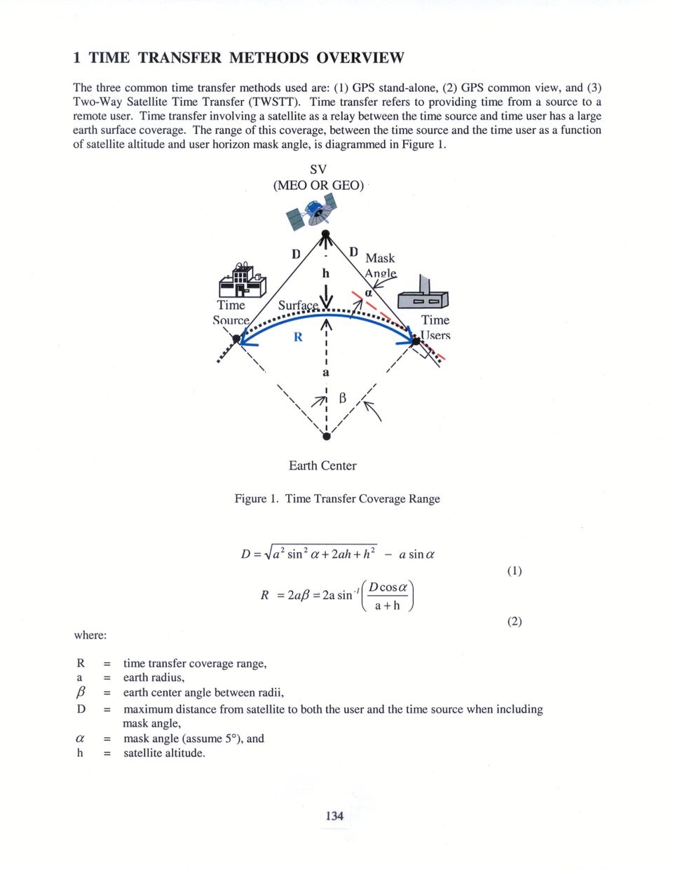
4 The range capability and general accuracy capability of the three common time transfer methods are shown in Figure 2. Time Transfer Surface Range (R) (nm) (5" Masking Angle) I I 9200 Time I Transfer Accuracy i-14 i<l (ns) I GPS I GPS I TWSTT I TWSTT Stand- I Common I ME0 Sat I GEO Sat nm Altitude nm Altktude Figure 2. Time Transfer Surface Range Versus Time Transfer Accuracy The simplest time transfer is the one-way GPS satellite vehicle (SV) stand-alone time transfer illustrated in Figure 3. GPS SV Today dal 15ns of UTC Figure 3. Stand-Alone The stand-alone method is the normal method used for time transfer and is the time output by a GPS receiver operating in a stand-alone mode. Today, the specification is for 100 nanoseconds (ns) GPS time transfer relative to UTC (USNO). However, the normally accuracy is about 15 ns due to better than specified performance by the GPS system. This system has worldwide coverage. With GPS JlI these accuracies are expected to improve. The GPS common-view time transfer method is used to transfer very accurate time over long distance inexpensively. Figure 4 illustrates the GPS common-view method. 135
 stand-alone time transfer illustrated in Figure 3.")
5 GPS SV & ::: Ltal&& & User Time Source (USNO) Today 3-517s of UTC Figure 4. Common View Common view means that the same GPS satellite(s) needs to be seen by both the time source and the user. GPS time from the satellite is used as a common time reference at the time source and at the user. Because it is common, the time errors of the satellite clock cancel out. Today, GPS common-view time transfer accuracy of 3-5 ns is achieved, which is better than the time accuracy obtained using the stand-alone method. The data link shown for the common-view approach does not require high data rates or low latency for precise time registration. This means that near-real-time low-cost data transfer methods are acceptable, e.g. use of the Internet. The user calculates (USNO master clock time minus GPS SV time) minus (User local time minus GPS SV time). The data link transfers the GPS satellite vehicle(s) being tracked at the USNO and the USNO Master Clock time minus GPS SV time. Constraints are that both the time source and the user must be viewing the same GPS satellite(s) at the same time. Advanced common-view concepts will provide for GPS all-in-view and carrier-phase operation, although a single GPS satellite and code phase have typically been used to date. The third time transfer method available is the two-way satellite time transfer as illustrated in Figure 5. Two-way time transfer refers to the process for comparing time between a reference clock and a remote user clock and then providing the time difference information to the user. The user can then adjust his time to the reference clock. This is the most accurate method of time transfer and has not used the GPS satellite system to date. Rather, geostationary earth orbit synchronous satellites (GEOS) have been used for this method. GEOS offer longer transfer ranges than the GPS satellites, but are very expensive to users because a satellite transponder channel must be leased, whereas GPS is free. Transponder SV Time Source (USNO) Today User -1-2 ns of UTC Figure 5. TWSTT 136

6 The time transfer range in equation (2) above applies. The same transponder channel and signal used for time transfer also transfers the data required for the time transfer calculations. Pseudo-randomnoise codes with phase shift key (PSK) modulation are used for the time transfer signal. This is the same type of signal used by the GPS satellites; therefore, the same type of correlators or the same correlators used for GPS could be used for correlation of the received two-way time transfer signal. Two-way satellite time transfer removes the satellite time errors and the RF channel time errors. Figure 6 shows a concept in which one satellite, i.e. GPS 111,could provide all of the time transfer methods, and the user then determines what time transfer method to use, depending upon what accuracy he needs and how cornpledexpensive the equipment is that he is willing to install. Future GPS SV (Notional) (USNO) - Future Ins of UTC Network Time Solution Figure 6. Multi-Time Transfer Methods This is a full service time capability. Future GPS upgradeskonstellations might provide as accurate or nearly as accurate time transfer as the common-view method. Therefore, the common-view method may not be required. This is still to be determined. However, both stand-alone and two-way time transfer are believed to be required. GPS could provide a global capability, free service, and a higher accuracy than provided with today's systems. Time transfer bandwidths of about 20 MHz are sufficient; however, less bandwidth is poss'ible, but will provide less time transfer accuracy. 2 TWO-WAY SATELLITE TIME TRANSFER TEST TESTPURPOSE The TWSTT test purpose was to demonstrate that precise time measurement difference between the USNO clock and a moving platform clock was feasible using a geostationary transponder satellite link. The challenges to this test were having continuous satellite carrier track, time measurements accuracy of &1ns, and determining the time correction factors resulting from the satellite to moving platform communication path changes. Other factors such as ionosphere, troposphere, Doppler shift, and moving platform relativistic effects were considered negligible for this test. 137

7
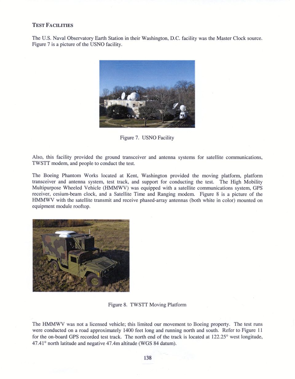
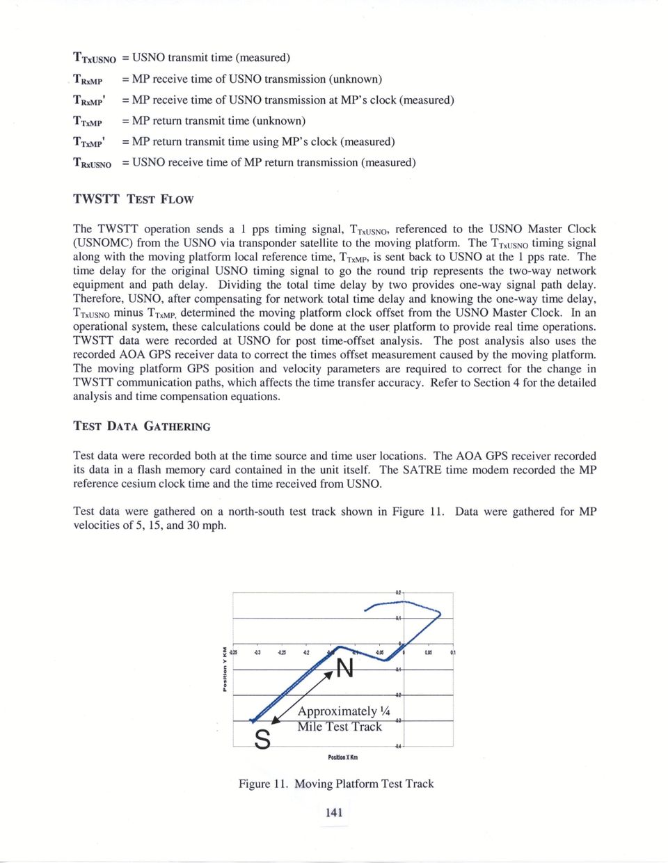
8 SITE TEST EQUIPMENT The USNO equipment at Washington, D.C. consisted of the Master Clock system; TimeTech Satellite Time and Ranging Equipment (SATRE) modem, Model Number S2CP-V4.30; and satellite communication Base Earth Stations, BEST 1 and BEST2. The HMMWV moving platform (MP) equipment consisted of Boeing's Satellite Communications System (Connexion), and the USNO-provided SATRE time transfer modem, TWSTFT-067; Allen Osborne Associates (AOA) GPS time transfer receiver, Model TTR12; GPS antenna with choke-ring; and a Hewlett-Packard 507 1A high-performance cesium-beam time standard. Note: For the remainder of the paper, the moving platform (MP) will be the used to identify the HMMWV. The transponder satellite used was the GE-1 located at 103" west longitude operating as a transponder in the Ku frequency band. TEST EQUIPMENT FUNCTIONAL DESCRIPTION The SATRE time modem is the interface between the USNO Master Clock for the reference time and the ground-based satellite communications hardware. The SATRE time modem has a 70 MHZ intermediate frequency (IF) input/output for a fullduplex full time continuous two-way time data flow. The time modem modulates the IF with direct sequencing pseudo-random noise spread spectrum. That is, the USNO time transmit data signal, TTx~~~O, modulates the carrier with a known pseudo-noise (PN) spreading code at a rate of 2.5 Mchip/s using bipolar phase-shift keying (BPSK) to phase-modulate the signal onto the 70 MHz IF. The moving platform (MP) SATRE time modem demodulates this signal by knowing the PN spreading code. See Figure 9. The SATRE time modem used on the moving platform was a modified version of those operated at ground installation sites. The modifications included data smoothing, data-recording software, and carrier-phase tracking loop control to operate on a moving platform. The SATRE time modem operation, without change, is for a stationary ground user installation with a 2-minute time constant for data smoothingkracking. The USNO satellite communications hardware consists of uplink and downlink equipment. The USNO uplink equipment.consists of a RF up-converter (70 MHz to 14 GHz range), solid-state power amplifier, and a Vertex 4.5 meter KPK Company Cassegrainian antenna. The USNO downlink from the satellite uses the same Vertex 4.5 meter antenna, a low noise amplifier, and a RF down-converter (1 lghz range to 70 MHz). The MP Allen Osborne Associates TTR-12 Time Transfer Receiver is a Y-codeless GPS receiver that outputs uncorrected pseudorange and delta-pseudorange data along with the broadcast ephemerides. See Figure 10. The same cesium clock provides the time reference to both the TWSTT time modem and the GPS time receiver. Boeing developed the software to postprocess the GPS receiver outputs in order to generate a moving-platform position, velocity, and time (PVT) solution. Three PVT estimation algorithms were developed: (1) an 1 1-state Kalman filter; (2) a 26-state Kalman filter; and (3) a point solution. 139

9 Receive Array Dow Converter V Control Status Antenna Controller Transmit Array Up Converter A 70 MHz A 70 MHz (TR~MP) (TT~MP) I ~~ Cesium Clock I Figure 9. Moving Platform TWSTT System GPS Antenna Cesium Clock e Figure 10. Moving Platform GPS System The Boeing Satellite Communication System, Connexion, has two phased array antennas located on top of the moving platform equipment module. The basic block diagram is shown in Figure 9. TIME PARAMETERS DEFINITION The following definitions are used: Tos TP = moving Platform (MP) clack offset time (offset from receive to transmit) (unknown) = path transmission time (one-way USNO to user or user to USNO) (unknown) 140

10
11 SYSTEM CALIBRATION The system used for this test was not calibrated for time delays. Rather, the cesium standard, HP 5071, was used as the stable user reference time standard and variations about this standard were recorded and treated as the time variations. This was done for cost and schedule purposes. The operational system would, however, need to be calibrated for time variations. The measured precision of the recorded twoway time transfer data was investigated, and from this, an accuracy was deduced based on past system calibration accuracy achieved. 3 DATA ANALYSIS DATA ANALYSIS FLOW Figure 12 shows the data analysis flow. Data were recorded at the USNO time source and at the Boeing time user locations and processed later. The GPS pseudorange and delta-pseudorange data were also sent to JPL for postprocessing using their GIPSY program. TWSTT DATA The raw TWSTT data shown in Figure 13 were corrected with the correction factors generated. The correction factors compensate for the user moving platform velocity and for the user TWSTT system transmit to receive antenna displacements. The data after correction is shown in Figure 14. GPS TIME TRANSFER DATA GPS stand-alone time transfer was also measured in addition to the two-way time transfer. Figure 15 shows the range of real time GPS time measurements for one run. These GPS measurements were post processed using the JPL GIPSY program and post processed data. A GPS time receiver was used in this test, so very accurate GPS time was also received. The results of the postprocessing shown in Figure 16 indicates approximately f 250 picoseconds of accuracy. The two-way red-time time transfer accuracy results, previously shown, are not quite as good as, but comparable to, the GPS postprocessed time data of Figure 16. KALMAN FILTER DESIGN As part of this test, we developed both 11-state and 26-state Kalman filters. The purpose of the Kalman filters are to process the pseudorange and delta-pseudorange outputs of the GPS receiver to provide user platform velocity and heading for generation of time corrections. 142

12

13
14 USNO receives the return signal at time TR~USNO = TT~MP + TP. The MP offset is calculated from USNO forward transmit time (TTxUS~0),USNO return receive time (TRxUSN0), and the MP clock versions of MP forward receive time (TRMp') and MP return transmit time (TTxMp'): - TT~MP') Tos,ca~c= [(TR~USNO - (TRxM; - TTxUSNO)] 1 2 This ideal situation fails to hold when the path transmission time is different for the forward and return paths. The forward and return paths are different in the MP experiment, because the MP employs separate receive and transmit antennas and because the MP is moving. This is shown in Figure 17. I I / From Satellite antenna location MP Receive antenna location Rlat time T R ~ M ~ Unit Vector Figure 17. MP Transmission Path Geometry If r is the displacement vector from MPs receive antenna to his transmit antenna and v is MP's velocity, then the vector displacement between the receive antenna at time TRmp (when the MP receives the forward signal) and the transmit antenna at time T T ~ (when P the MP transmits the return signal) is: This vector reffis the MPs effective differential displacement for the return path relative to the forward path. The user can use his own clock to measure the time delay TTxMp - TRxMp, because TTfip' - TR&p' = TTap - TRMp If the user knows his velocity, then he can calculate ree. The component of reffperpendicular to the transmission path produces a negligible change in path length, because the magnitude of reffis very small relative to the satellite-to-mp range. Only the component of ren parallel to the transmission path changes the path length. 145
![(TTxMp'): - TT~MP') Tos,ca~c= [(TR~USNO - (TRxM; - TTxUSNO)] 1 2 This ideal situation fails to hold when the path transmission time is different for the forward and return paths.](/docs-images/48/18855233/images/page_14.jpg "The forward and return paths are different in the MP experiment, because the MP employs separate receive and transmit antennas and because the MP is moving. This is shown in Figure 17.")
15 The return path is longer than the forward path by AL = fi, 0 ren, where cs is the unit vector from satellite to MP. If the forward-path transmission time from USNO to MP is Tp, then the return path transmission time from MP to USNO is Tp + ATp, where and c is the speed of light. The time at which USNO receives the return signal is now given by: The calculated MP offset time becomes: Thus, a correction factor Tc = -ATp / 2 must be added to the calculated MP offset time Tos,~~~~ to compensate MP receive to transmit antenna displacement r and velocity v. This correction factor is as follows: where: TC = time transfer correction, r = antenna displacement vector T ~MP = MP receive time of USNO transmission, TT~MP = MP return transmit time, v = velocity vector, 6s = unit vector from satellite to user, c = speed of light, and = dot product. The equation (3) correction factor was applied to data in Figure 13, resulting in the data shown in Figure 14. The straight line of the corrected data shows the correction factor corrects very well. The MP experiment was set up so that both USNO and the MP transmitted at the same time. That is, TT~MP = TT~USNO. Since T ~ap = TTx~sNO + Tp, the time delay T T ~ TRfip ~ - in the expression for Tc becomes: 146

16 The path transmission time TP was calculated from the USNO, satellite, and MP locations, and was found to be seconds. 5 TWSTT TO MOVING PLATFORM CONCLUSION The two-way satellite time transfer test to a moving platform was successful. Less than 1 nanosecond of time transfer error is indicated after applying corrections and filtering. Scatter plots show that the precision of the time transfer readings were usually within f 0.5 nanoseconds. A smooth time transfer capability was shown after the calculated corrections for the user velocity and the antenna placements were applied to the raw data. The recommended next steps are: 0 Generate TWSTT error budget 0 Show that either a ME0 or GEO satellite can be used for time transfer (implications of faster velocities) 0 Reduce transmit time between receive to transmit in the user time modem 0 Perform TWSTT to an aircraft in flight 0 Investigate methods for data transfer between platforms using the TWSTT RF transmission links It is expected that the two-way time transfer to a moving platform will have many users in the military and scientific communities. Uses such as multi-aircraft sensor fusion and obtaining accurate relative time at multi-locations are prime candidates. However, further development is required to make this most time accurate time transfer method available to moving platforms. Additional tests on high velocity platforms are needed. 6 TWSTT FOLLOW-ON EFFORT USNO plans to determine the modifications needed to update the TimeTech SATRE time modem for higher velocity operation and for reduced time delay interval between receive and transmit. Follow-on TWSTT testing is pending, based on available hardware and participants budget availability. 7 ACKNOWLEDGMENTS Others who contributed are Lisa Nelson, Phu Mai, Jim DeYoung, and Paul Wheeler from USNO and Mike Pounds and Richard Bowers from Boeing. 147

17 QUESTIONS AND ANSWERS SIGFRIDO LESCHIUTTA (Politecnico di Torino and Istituto Eletrotecnico Nazionale): The phased array antenna was used just to have a local antenna, or was it used in order to have a directional beam? ED POWERS: It is a real active phased ray antenna with multiple elements that are actively phase-shifted to steer a beam to the satellite. So it is a full beam-steered antenna. It is not just a flat-looking dish; it is a true beam-steered antenna. 148

A GPS Digital Phased Array Antenna and Receiver
 A GPS Digital Phased Array Antenna and Receiver Dr. Alison Brown, Randy Silva; NAVSYS Corporation ABSTRACT NAVSYS High Gain Advanced GPS Receiver (HAGR) uses a digital beam-steering antenna array to enable
Remote Calibration of a GPS Timing Receiver to UTC(NIST) via the Internet*
 via the Internet*") Remote Calibration of a GPS Timing Receiver to UTC(NIST) via the Internet* Michael A. Lombardi and Andrew N. Novick National Institute of Standards and Technology Boulder, Colorado [email protected]
Remote Calibration of a GPS Timing Receiver to UTC(NIST) via the Internet* Michael A. Lombardi and Andrew N. Novick National Institute of Standards and Technology Boulder, Colorado [email protected]
Overview Presented by: Boyd L. Summers
 Overview Presented by: Boyd L. Summers Systems & Software Technology Conference SSTC May 19 th, 2011 1 Report Documentation Page Form Approved OMB No. 0704-0188 Public reporting burden for the collection
Report Documentation Page
 (c)2002 American Institute Report Documentation Page Form Approved OMB No. 0704-0188 Public reporting burden for the collection of information is estimated to average 1 hour per response, including the
General GPS Antenna Information APPLICATION NOTE
 General GPS Antenna Information APPLICATION NOTE General GPS Antenna Information Global Positioning System and Precise Time & Frequency The Global Positioning System (GPS) is a worldwide radio-navigation
Bi-Directional DGPS for Range Safety Applications
 Bi-Directional DGPS for Range Safety Applications Ranjeet Shetty 234-A, Avionics Engineering Center, Russ College of Engineering and Technology, Ohio University Advisor: Dr. Chris Bartone Outline Background
Using the Advancement Degree of Difficulty (AD 2 ) as an input to Risk Management
 as an input to Risk Management") Using the Advancement Degree of Difficulty (AD 2 ) as an input to Risk Management James W. Bilbro JB Consulting International Huntsville, AL Multi-dimensional Assessment of Technology Maturity Technology
Using the Advancement Degree of Difficulty (AD 2 ) as an input to Risk Management James W. Bilbro JB Consulting International Huntsville, AL Multi-dimensional Assessment of Technology Maturity Technology
Satellite Basics. Benefits of Satellite
 Satellite Basics Benefits of Satellite People need access to enterprise-class, high-speed voice, video and data applications wherever they happen to be. Satellite connectivity has the power to drive communications
GENERAL INFORMATION ON GNSS AUGMENTATION SYSTEMS
 GENERAL INFORMATION ON GNSS AUGMENTATION SYSTEMS 1. INTRODUCTION Navigation technologies with precision approach and landing systems, for civilian and military purposes, enable aircrafts to perform their
Asset Management- Acquisitions
 Indefinite Delivery, Indefinite Quantity (IDIQ) contracts used for these services: al, Activity & Master Plans; Land Use Analysis; Anti- Terrorism, Circulation & Space Management Studies; Encroachment
Environmental Monitoring: Guide to Selecting Wireless Communication Solutions
 Environmental Monitoring: Guide to Selecting Wireless Communication Solutions By: Scott South Published in WaterWorld, January 2005 (Page 48) Rapidly growing demands for information and increased productivity
EAD Expected Annual Flood Damage Computation
 US Army Corps of Engineers Hydrologic Engineering Center Generalized Computer Program EAD Expected Annual Flood Damage Computation User's Manual March 1989 Original: June 1977 Revised: August 1979, February
PERFORMANCE EVALUATION OF THE GPS BLOCK IIR TIME KEEPING SYSTEM
 PERFORMANCE EVALUATION OF THE GPS BLOCK IIR TIME KEEPING SYSTEM Andy Wu The Aerospace Corporation 4452 Canoga Drive, Woodland Hills, California 91364, USA (310) 336-0437 (telephone), (310) 336-5076 (fax)
BASICS OF C & Ku BAND TRANSMISSIONS & LNBs
 Page 1 of 6 BASICS OF C & Ku BAND TRANSMISSIONS & LNBs A satellite broadcasts a few watts of microwave signals from the geostationary orbit 36,000 kilometers above the earth. The transmissions are also
Mobile Communications: Satellite Systems
 Mobile Communications: Satellite Systems Mobile Communication: Satellite Systems - Jochen Schiller http://www.jochenschiller.de 1 History of satellite communication 1945 Arthur C. Clarke publishes an essay
Time and frequency distribution using satellites
 INSTITUTE OF PHYSICS PUBLISHING Rep. Prog. Phys. 65 (2002) 1119 1164 REPORTS ON PROGRESS IN PHYSICS PII: S0034-4885(02)98967-0 Time and frequency distribution using satellites Judah Levine Time and Frequency
Post Processing Service
 Post Processing Service The delay of propagation of the signal due to the ionosphere is the main source of generation of positioning errors. This problem can be bypassed using a dual-frequency receivers
102 26-m Antenna Subnet Telecommunications Interfaces
 DSMS Telecommunications Link Design Handbook 26-m Antenna Subnet Telecommunications Interfaces Effective November 30, 2000 Document Owner: Approved by: Released by: [Signature on file in TMOD Library]
Mobile Computing. Chapter 5: Satellite Systems
 Mobile Computing Chapter 5: Satellite Systems Prof. Sang-Jo Yoo History of satellite communication 1945 Arthur C. Clarke publishes an essay about Extra Terrestrial Relays 1957 First satellite SPUTNIK by
The NASA Global Differential GPS System (GDGPS) and The TDRSS Augmentation Service for Satellites (TASS)
 and The TDRSS Augmentation Service for Satellites (TASS)") The Global Differential GPS System (GDGPS) and The TDRSS Augmentation Service for Satellites (TASS) Yoaz Bar-Sever, Larry Young, Frank Stocklin, Paul Heffernan and John Rush s Global Differential GPS System
The Global Differential GPS System (GDGPS) and The TDRSS Augmentation Service for Satellites (TASS) Yoaz Bar-Sever, Larry Young, Frank Stocklin, Paul Heffernan and John Rush s Global Differential GPS System
THE STEERING OF A REAL TIME CLOCK TO UTC(NBS) AND TO UTC by
 AND TO UTC by") THE STEERNG OF A REAL TME CLOCK TO UTC(NBS) AND TO UTC by J. Levine and D.W. Allan Time and Frequency Division National nstitute of Standards and Technology Boulder, Colorado 833 ABSTRACT We describe the
THE STEERNG OF A REAL TME CLOCK TO UTC(NBS) AND TO UTC by J. Levine and D.W. Allan Time and Frequency Division National nstitute of Standards and Technology Boulder, Colorado 833 ABSTRACT We describe the
INTRODUCTION TO COMMUNICATION SYSTEMS AND TRANSMISSION MEDIA
 COMM.ENG INTRODUCTION TO COMMUNICATION SYSTEMS AND TRANSMISSION MEDIA 9/6/2014 LECTURES 1 Objectives To give a background on Communication system components and channels (media) A distinction between analogue
DCAA and the Small Business Innovative Research (SBIR) Program
 Program") Defense Contract Audit Agency (DCAA) DCAA and the Small Business Innovative Research (SBIR) Program Judice Smith and Chang Ford DCAA/Financial Liaison Advisors NAVAIR 2010 Small Business Aviation Technology
Defense Contract Audit Agency (DCAA) DCAA and the Small Business Innovative Research (SBIR) Program Judice Smith and Chang Ford DCAA/Financial Liaison Advisors NAVAIR 2010 Small Business Aviation Technology
Advanced Micro Ring Resonator Filter Technology
 Advanced Micro Ring Resonator Filter Technology G. Lenz and C. K. Madsen Lucent Technologies, Bell Labs Report Documentation Page Form Approved OMB No. 0704-0188 Public reporting burden for the collection
HANDBOOK. Measuring System DESIGN EDITORS PETER H. SYDENHAM RICHARD THORN ARTICLE OFFPRINT
 HANDBOOK OF Measuring System DESIGN EDITORS PETER H. SYDENHAM RICHARD THORN ARTICLE OFFPRINT 200: Calibrations and Standards in Time Measurement Michael A. Lombardi National Institute of Standards and
DEFENSE CONTRACT AUDIT AGENCY
 DEFENSE CONTRACT AUDIT AGENCY Fundamental Building Blocks for an Acceptable Accounting System Presented by Sue Reynaga DCAA Branch Manager San Diego Branch Office August 24, 2011 Report Documentation Page
Dr. Gary S. E. Lagerloef Earth and Space Research, 1910 Fairview Ave E
 Establishing a NOAA Operational Data Center for Surface Currents Derived from Satellite Altimeters and Scatterometers; Pilot Study for the Tropical Pacific Including the Hawaiian Islands and US Territorial
RT 24 - Architecture, Modeling & Simulation, and Software Design
 RT 24 - Architecture, Modeling & Simulation, and Software Design Dennis Barnabe, Department of Defense Michael zur Muehlen & Anne Carrigy, Stevens Institute of Technology Drew Hamilton, Auburn University
Mobile Communications Chapter 5: Satellite Systems
 History of satellite communication Mobile Communications Chapter 5: Satellite Systems History Basics Orbits LEO, MEO, GEO Examples Handover, Routing 1945 Arthur C. Clarke publishes an essay about Extra
SATELLITE TIME-TRANSFER: RECENT DEVELOPMENTS AND PROJECTS
 SATELLITE TIME-TRANSFER: RECENT DEVELOPMENTS AND PROJECTS W. LEWANDOWSKI 1 and J. NAWROCKI 2 1 Bureau International des Poids et Mesures, Sèvres, France e-mail: [email protected] 2 Astrogeodynamical
Headquarters U.S. Air Force
 Headquarters U.S. Air Force I n t e g r i t y - S e r v i c e - E x c e l l e n c e Air Force Technology Readiness Assessment (TRA) Process for Major Defense Acquisition Programs LtCol Ed Masterson Mr
UNCLASSIFIED LOW-COST MINIATURE INTERFACE AND CONTROL SYSTEMS FOR SMART SENSORS, TACTICAL RADIOS, AND COMPUTER NETWORKS
 LOW-COST MINIATURE INTERFACE AND CONTROL SYSTEMS FOR SMART SENSORS, TACTICAL RADIOS, AND COMPUTER NETWORKS Brett Martin and Dale Bryan Naval Command, Control, and Ocean Surveillance Center Research, Development,
General Survey of Radio Frequency Bands 30 MHz to 3 GHz
 General Survey of Radio Frequency Bands 30 MHz to 3 GHz Version 2.0 September 23, 2010 Prepared by: Shared Spectrum Company 1595 Spring Hill Road Suite 110 Vienna, VA 22182-2228 703-761-2818 Fax: 703-761-2817
5. Satellite Systems. History of Satellite Communications
 5. Satellite Systems History and Orbits Routing, Localization, and Hand-over Systems 2005 Burkhard Stiller and Jochen Schiller FU Berlin M5 1 History of Satellite Communications 1945 Arthur C. Clarke about
Satellite Communication Systems. mgr inż. Krzysztof Włostowski Instytut Telekomunikacji PW [email protected]
 Satellite Communication Systems mgr inż. Krzysztof Włostowski Instytut Telekomunikacji PW [email protected] Satellite Communication Satellite Communication combines the missile and microwave technologies
John Mathieson US Air Force (WR ALC) Systems & Software Technology Conference Salt Lake City, Utah 19 May 2011
 Systems & Software Technology Conference Salt Lake City, Utah 19 May 2011") John Mathieson US Air Force (WR ALC) Systems & Software Technology Conference Salt Lake City, Utah 19 May 2011 Report Documentation Page Form Approved OMB No. 0704-0188 Public reporting burden for the
John Mathieson US Air Force (WR ALC) Systems & Software Technology Conference Salt Lake City, Utah 19 May 2011 Report Documentation Page Form Approved OMB No. 0704-0188 Public reporting burden for the
Telephony Solution for Local Multi-Point Distribution Service
 Telephony Solution for Local Multi-Point Distribution Service Derek Lam Computer Systems Laboratory Aly F. Elrefaie, Lynn Plouse, Yee-Hsiang Chang Video Communications Division HPL-97-165 December, 1997
8. Communications Subsystem
 PM-1.1-03 Rev C 8. Communications Subsystem The GOES-NOP spacecraft communications subsystem provides requisite conditioning, transmission, reception, and routing of mission data signals and telemetry
STANDARDS TO ACCESS AND OPERATE SATELLITE SERVICES
 STANDARDS TO ACCESS AND OPERATE SATELLITE SERVICES INDEX I. Scope... 3 II. Bandwidth and Power Standards... 3 A. Bandwidth (BW) Allocation and Measurement... 3 1. Bandwidth of a digital carrier per customer....
Phase coherency of CDMA caller location processing based on TCXO frequency reference with intermittent GPS correction
 Phase coherency of CDMA caller location processing based on TCXO frequency reference with intermittent GPS correction Dingchen Lu, Alfredo Lopez, Surendran K. Shanmugam, John Nielsen and Gerard Lachapelle
Enabling RTK-like positioning offshore using the global VERIPOS GNSS network. Pieter Toor GNSS Technology Manager
 Enabling RTK-like positioning offshore using the global VERIPOS GNSS network Pieter Toor GNSS Technology Manager Introduction PPP/RTK Positioning Techniques PPP-AR Technology Presentation Overview PPP-AR
Integrated Force Method Solution to Indeterminate Structural Mechanics Problems
 NASA/TP 2004-207430 Integrated Force Method Solution to Indeterminate Structural Mechanics Problems Surya N. Patnaik Ohio Aerospace Institute, Brook Park, Ohio Dale A. Hopkins and Gary R. Halford Glenn
Addressing the Real-World Challenges in the Development of Propulsion IVHM Technology Experiment (PITEX)
") NASA/CR 2005-213422 AIAA 2004 6361 Addressing the Real-World Challenges in the Development of Propulsion IVHM Technology Experiment (PITEX) William A. Maul, Amy Chicatelli, and Christopher E. Fulton Analex
NASA/CR 2005-213422 AIAA 2004 6361 Addressing the Real-World Challenges in the Development of Propulsion IVHM Technology Experiment (PITEX) William A. Maul, Amy Chicatelli, and Christopher E. Fulton Analex
TI GPS PPS Timing Application Note
 Application Note Version 0.6 January 2012 1 Contents Table of Contents 1 INTRODUCTION... 3 2 1PPS CHARACTERISTICS... 3 3 TEST SETUP... 4 4 PPS TEST RESULTS... 6 Figures Figure 1 - Simplified GPS Receiver
CDMA Technology : Pr. S. Flament www.greyc.fr/user/99. Pr. Dr. W. sk www.htwg-konstanz.de. On line Course on CDMA Technology
 CDMA Technology : Pr. Dr. W. sk www.htwg-konstanz.de Pr. S. Flament www.greyc.fr/user/99 On line Course on CDMA Technology CDMA Technology : CDMA / DS : Principle of operation Generation of PN Spreading
RECOMMENDATION ITU-R F.1113. (Question ITU-R 157/9) b) that systems using this mode of propagation are already in service for burst data transmission,
 b) that systems using this mode of propagation are already in service for burst data transmission,") Rec. ITU-R F.1113 1 RECOMMENDATION ITU-R F.1113 RADIO SYSTEMS EMPLOYING METEOR-BURST PROPAGATION (Question ITU-R 157/9) (1994) Rec. ITU-R F.1113 The ITU Radiocommunication Assembly, considering a) that
Rec. ITU-R F.1113 1 RECOMMENDATION ITU-R F.1113 RADIO SYSTEMS EMPLOYING METEOR-BURST PROPAGATION (Question ITU-R 157/9) (1994) Rec. ITU-R F.1113 The ITU Radiocommunication Assembly, considering a) that
REAL-TIME GPS MONITORING OF ATOMIC FREQUENCY STANDARDS IN THE CANADIAN ACTIVE CONTROL SYSTEM (CACS)
") 30th Annual Pmbe Time and Time Internal (PTTI) Meeting REAL-TIME GPS MONITORING OF ATOMIC FREQUENCY STANDARDS IN THE CANADIAN ACTIVE CONTROL SYSTEM (CACS) F. Lahaye, M. Caissy, J. Popelar Geodetic Survey
30th Annual Pmbe Time and Time Internal (PTTI) Meeting REAL-TIME GPS MONITORING OF ATOMIC FREQUENCY STANDARDS IN THE CANADIAN ACTIVE CONTROL SYSTEM (CACS) F. Lahaye, M. Caissy, J. Popelar Geodetic Survey
GPS CARRIER-PHASE FREQUENCY TRANSFER ON THE NIMA MONITOR STATION NETWORK
 33rdAnnual Precise Time and Time Interval (PTTI)Meeting GPS CARRIER-PHASE FREQUENCY TRANSFER ON THE NIMA MONITOR STATION NETWORK B. W. Tolman and D. Munton Satellite Geophysics Laboratory Applied Research
ELECTRONIC HEALTH RECORDS. Fiscal Year 2013 Expenditure Plan Lacks Key Information Needed to Inform Future Funding Decisions
 United States Government Accountability Office Report to Congressional July 2014 ELECTRONIC HEALTH RECORDS Fiscal Year 2013 Expenditure Plan Lacks Key Information Needed to Inform Future Funding Decisions
Chapter 4 Solution to Problems
 Chapter 4 Solution to Problems Question #1. A C-band earth station has an antenna with a transmit gain of 54 db. The transmitter output power is set to 100 W at a frequency of 6.100 GHz. The signal is
73rd MORSS CD Cover Page UNCLASSIFIED DISCLOSURE FORM CD Presentation
 73rd MORSS CD Cover Page UNCLASSIFIED DISCLOSURE FORM CD Presentation 21-23 June 2005, at US Military Academy, West Point, NY 712CD For office use only 41205 Please complete this form 712CD as your cover
Smart LNB. White Paper. May 2014
 Smart LNB White Paper May 2014 This document contains information proprietary to Ayecka Communication Systems Ltd. and may not be reproduced in whole or in part without the express written consent of Ayecka
Rocket Science Made Simple
 Rocket Science Made Simple Satellite Connectivity For Aviation Explained George Nicola 1 and Michele Franci 2 Inmarsat, London, EC1Y 1AX, United Kingdom Any satellite communication system is required to
RF Network Analyzer Basics
 RF Network Analyzer Basics A tutorial, information and overview about the basics of the RF Network Analyzer. What is a Network Analyzer and how to use them, to include the Scalar Network Analyzer (SNA),
Overview of LEO Satellite Systems
 Overview of LEO Satellite Systems Christopher Redding Institute for Telecommunication Sciences National Telecommunications and Information Administration Boulder, CO credding@its. @its.bldrdoc.gov 1999
Global Positioning System
 B. Hofmann-Wellenhof, H. Lichtenegger, and J. Collins Global Positioning System Theory and Practice Third, revised edition Springer-Verlag Wien New York Contents Abbreviations Numerical constants xix xxiii
REPORT DOCUMENTATION PAGE *
 REPORT DOCUMENTATION PAGE * Form Approved OMBNo. 07040188 Public reporting burden for this collection of information is estimated to average 1 hour per response, including the time for reviewing instructions,
Mobile Communications Chapter 5: Satellite Systems
 Mobile Communications Chapter 5: Satellite Systems History Basics Localization Handover Routing Systems History of satellite communication 1945 Arthur C. Clarke publishes an essay about Extra Terrestrial
METHODS OF GATHERING EGM DATA Stephen Easley TXU Lone Star Pipeline
 METHODS OF GATHERING EGM DATA Stephen Easley TXU Lone Star Pipeline 301 South Harwood St., Dallas, TX 75201 INTRODUCTION Today s changing world of computers and data communications is an exciting time
Propsim enabled Aerospace, Satellite and Airborne Radio System Testing
 www.anite.com Propsim enabled Aerospace, Satellite and Airborne Radio System Testing Anite is now part of Keysight Technologies Realistic and repeatable real-time radio channel emulation solutions for
Evolution of Satellite Communication Systems
 Mathieu DERVIN Brussels, 6th May 2015 Brussels, May 2015 Agenda I. From Sputnik to wideband satellite services: The key technological evolutions II. Increase the satellite system capacity: A global system
Multiple Network Marketing coordination Model
 REPORT DOCUMENTATION PAGE Form Approved OMB No. 0704-0188 The public reporting burden for this collection of information is estimated to average 1 hour per response, including the time for reviewing instructions,
Secure Navigation and Authentication. Sherman Lo November 2008
 Secure Navigation and Authentication Sherman Lo November 2008 1 Outline Motivating Authentication Proposed techniques for authentication Source authentication Cross checking My research 2 GNSS: Position,
Pima Community College Planning Grant For Autonomous Intelligent Network of Systems (AINS) Science, Mathematics & Engineering Education Center
 Science, Mathematics & Engineering Education Center") Pima Community College Planning Grant For Autonomous Intelligent Network of Systems (AINS) Science, Mathematics & Engineering Education Center Technical Report - Final Award Number N00014-03-1-0844 Mod.
Pima Community College Planning Grant For Autonomous Intelligent Network of Systems (AINS) Science, Mathematics & Engineering Education Center Technical Report - Final Award Number N00014-03-1-0844 Mod.
CDMA Technology : Principles of CDMA/DS Decoding
 CDMA Technology : Principles of CDMA/DS Decoding Pr. Dr. W.Skupin www.htwg-konstanz.de Pr. S.Flament www.greyc.fr/user/99 On line Course on CDMA Technology CDMA Technology : Introduction to Spread Spectrum
CERT Virtual Flow Collection and Analysis
 CERT Virtual Flow Collection and Analysis For Training and Simulation George Warnagiris 2011 Carnegie Mellon University Report Documentation Page Form Approved OMB No. 0704-0188 Public reporting burden
Electric utilities may vary in their application of end-to-end testing
 An Application Case of End-to-End Relay Testing of Communication-Based Protection Schemes Using GPS-Synchronized Secondary Injection Feature by J. Ariza, Megger USA G. Ibarra, CFE, Mexico Electric utilities
Frequencies for Mars Local High-Rate Links
 IPN Progress Report 42-153 May 15, 2003 Frequencies for Mars Local High-Rate Links D. Hansen, 1 M. Sue, 1 T. Peng, 2 and F. Manshadi 2 This article considers the options for frequency choice for high-data-rate
Positioning in GSM. Date: 14th March 2003
 Positioning in GSM Date: 14th March 2003 Overview of seminar Potential applications in cellular network Review of localization system and techniques Localization in GSM system Progress of the project with
Wide Area Inverse DGPS For Fleet Operations
 Wide Area Inverse DGPS For Fleet Operations By: James W. Bradley H. Keith Smith Anil Tiwari Vice President Vice President, Development Independent Consultant Differential Corrections Inc. TechnoCom Corporation
SHOALS Toolbox: Software to Support Visualization and Analysis of Large, High-Density Data Sets
 SHOALS Toolbox: Software to Support Visualization and Analysis of Large, High-Density Data Sets by Jennifer M. Wozencraft, W. Jeff Lillycrop, and Nicholas C. Kraus PURPOSE: The Coastal and Hydraulics Engineering
Department of Electrical and Computer Engineering Ben-Gurion University of the Negev. LAB 1 - Introduction to USRP
 Department of Electrical and Computer Engineering Ben-Gurion University of the Negev LAB 1 - Introduction to USRP - 1-1 Introduction In this lab you will use software reconfigurable RF hardware from National
PDHonline Course L105 (12 PDH) GPS Surveying. Instructor: Jan Van Sickle, P.L.S. PDH Online PDH Center
 GPS Surveying. Instructor: Jan Van Sickle, P.L.S. PDH Online PDH Center") PDHonline Course L105 (12 PDH) GPS Surveying Instructor: Jan Van Sickle, P.L.S. 2012 PDH Online PDH Center 5272 Meadow Estates Drive Fairfax, VA 22030-6658 Phone & Fax: 703-988-0088 www.pdhonline.org www.pdhcenter.com
PDHonline Course L105 (12 PDH) GPS Surveying Instructor: Jan Van Sickle, P.L.S. 2012 PDH Online PDH Center 5272 Meadow Estates Drive Fairfax, VA 22030-6658 Phone & Fax: 703-988-0088 www.pdhonline.org www.pdhcenter.com
Time transfer with nanosecond accuracy for the realization of International Atomic Time
 IOP PUBLISHING Metrologia 45 (008) 185 198 METROLOGIA doi:10.1088/006-1394/45//008 Time transfer with nanosecond accuracy for the realization of International Atomic Time D Piester 1, A Bauch 1, L Breakiron,
Signaling Conformance Option
 spirent C2K-ATS The Signaling Conformance solution for the C2K-ATS platform automates Signaling Conformance testing of CDMA 1X and EV-DO mobile devices. APPLICATIONS Product Development Design Verification
APPLICATION CASE OF THE END-TO-END RELAY TESTING USING GPS-SYNCHRONIZED SECONDARY INJECTION IN COMMUNICATION BASED PROTECTION SCHEMES
 APPLICATION CASE OF THE END-TO-END RELAY TESTING USING GPS-SYNCHRONIZED SECONDARY INJECTION IN COMMUNICATION BASED PROTECTION SCHEMES J. Ariza G. Ibarra Megger, USA CFE, Mexico Abstract This paper reviews
IISUP-. NAVAL SUPPLY SVSTE:MS COMMAND. Ready. Resourceful. Responsive!
 ~ IISUP-. NAVAL SUPPLY SVSTE:MS COMMAND Ready. Resourceful. Responsive! Report Documentation Page Form Approved OMB No. 0704-0188 Public reporting burden for the collection of information is estimated
Guide to Using DoD PKI Certificates in Outlook 2000
 Report Number: C4-017R-01 Guide to Using DoD PKI Certificates in Outlook 2000 Security Evaluation Group Author: Margaret Salter Updated: April 6, 2001 Version 1.0 National Security Agency 9800 Savage Rd.
Clocking. Clocking in the Digital Network
 Clocking Clocking in the Digital Network Stratum Levels Clocking Distribution Single Point versus Multiple Points Timing Differences Correcting Timing Errors Buffers 1 Clocking The most important aspect
Optical Blade Position Tracking System Test
 National Renewable Energy Laboratory Innovation for Our Energy Future A national laboratory of the U.S. Department of Energy Office of Energy Efficiency & Renewable Energy Optical Blade Position Tracking
SHARING BETWEEN TERRESTRIAL FLIGHT TELEPHONE SYSTEM (TFTS) AND RADIO ASTRONOMY IN THE 1.6 GHz BAND. Paris, May 1992
 AND RADIO ASTRONOMY IN THE 1.6 GHz BAND. Paris, May 1992") European Radiocommunications Committee (ERC) within the European Conference of Postal and Telecommunications Administrations (CEPT) SHARING BETWEEN TERRESTRIAL FLIGHT TELEPHONE SYSTEM (TFTS) AND RADIO
European Radiocommunications Committee (ERC) within the European Conference of Postal and Telecommunications Administrations (CEPT) SHARING BETWEEN TERRESTRIAL FLIGHT TELEPHONE SYSTEM (TFTS) AND RADIO
BR Workshop on the efficient use of the spectrum/orbit resource (Geneva, 6 May 2009)
") BR Workshop on the efficient use of the spectrum/orbit resource (Geneva, 6 May 2009) Spectrum inefficiencies resulting from the claimed use of steerable beams, multiple beams or large coverage area beams
BR Workshop on the efficient use of the spectrum/orbit resource (Geneva, 6 May 2009) Spectrum inefficiencies resulting from the claimed use of steerable beams, multiple beams or large coverage area beams
High Resolution RF Analysis: The Benefits of Lidar Terrain & Clutter Datasets
 0 High Resolution RF Analysis: The Benefits of Lidar Terrain & Clutter Datasets January 15, 2014 Martin Rais 1 High Resolution Terrain & Clutter Datasets: Why Lidar? There are myriad methods, techniques
Satellite Telemetry, Tracking and Control Subsystems
 Satellite Telemetry, Tracking and Control Subsystems Col John E. Keesee 1 Overview The telemetry, tracking and control subsystem provides vital communication to and from the spacecraft TT&C is the only
0HDVXULQJWKHHOHFWULFDOSHUIRUPDQFH FKDUDFWHULVWLFVRI5),)DQGPLFURZDYHVLJQDO SURFHVVLQJFRPSRQHQWV
,)DQGPLFURZDYHVLJQDO SURFHVVLQJFRPSRQHQWV") 0HDVXULQJWKHHOHFWULFDOSHUIRUPDQFH FKDUDFWHULVWLFVRI5),)DQGPLFURZDYHVLJQDO SURFHVVLQJFRPSRQHQWV The treatment given here is introductory, and will assist the reader who wishes to consult the standard texts
0HDVXULQJWKHHOHFWULFDOSHUIRUPDQFH FKDUDFWHULVWLFVRI5),)DQGPLFURZDYHVLJQDO SURFHVVLQJFRPSRQHQWV The treatment given here is introductory, and will assist the reader who wishes to consult the standard texts
Spectrum and Power Measurements Using the E6474A Wireless Network Optimization Platform
 Application Note Spectrum and Power Measurements Using the E6474A Wireless Network Optimization Platform By: Richard Komar Introduction With the rapid development of wireless technologies, it has become
AFRL-RX-WP-TP-2008-4023
 AFRL-RX-WP-TP-2008-4023 HOW KILLDEER MOUNTAIN MANUFACTURING IS OPTIMIZING AEROSPACE SUPPLY CHAIN VISIBILITY USING RFID (Postprint) Jeanne Duckett Killdeer Mountain Manufacturing, Inc. FEBRUARY 2008 Final
MITSUBISHI ELECTRIC ANNOUNCES THE SUCCESSFUL DEVELOPMENT OF AN AIRBORNE Ku-BAND ANTENNA SUBSYSTEM FOR SATELLITE COMMUNICATIONS
 FOR IMMEDIATE RELEASE No. 2330 Product Inquiries: Media Contact: Yutaka Kamada Oliver Cox Mitsubishi Electric Corporation Mitsubishi Electric Corporation Tel: +81-3-3218-2391 Tel: +81-3-3218-2346 [email protected]
SATELLITE COMMUNICATION
 SATELLITE COMMUNICATION By Gaurish Kumar Tripathi. 1.0 INTRODUCTION: The use of satellite in communication system is very much a fact of everyday in life. This is evidence by the many homes, which are
International Journal of Research in Advent Technology Available Online at: http://www.ijrat.org
 DESIGN AND IMPLEMENTATION OF A GPS RECEIVER USING 8051 MICROCONTROLLER Garima Jain 1, Nasreen Noorani 2, Vishal Badole 3 1 2 3 Electronics & Communication Department 1 2 3 Acropolis Technical Campus, Indore,
Introduction to Receivers
 Introduction to Receivers Purpose: translate RF signals to baseband Shift frequency Amplify Filter Demodulate Why is this a challenge? Interference (selectivity, images and distortion) Large dynamic range
TWO-WAY INTERNET OVER ipstar USING ADVANCED ERROR CORRECTION AND DYNAMIC LINKS
 AIAA-2002-1944 TWO-WAY INTERNET OVER ipstar USING ADVANCED ERROR CORRECTION AND DYNAMIC LINKS William Thesling*, Mark Vanderaar*, Mark Thompson**, Peter Hamilton**, Paiboon Panuwattanawong*** and Richard