Permanent GNSS station network and AlpCheck: freight transport monitoring
|
|
|
- Clementine Elliott
- 10 years ago
- Views:
Transcription
1 Permanent GNSS station network and AlpCheck: freight transport monitoring 19 th June 2008 Giorgio Gaber Auditorium Palazzo della Regione Lombardia MILAN Francesco Matonti IREALP

2 Project summary Problems related to data sharing on mobility are evident, mainly due to differences in the data collection systems that lead to a difficult homogenization. AlpCheck aim is to create an information system able to manage data coming from the existing monitoring systems in the Alpine area. It should be global but it will have to adapt itself to the characteristics of each user. The system has to adapt itself to multiple requirements and various contexts and different typologies of travel. The IREALP Pilot Project in collaboration with SLALA IREALP (Regione Lombardia, satellite systems) cooperates with SLALA (Regione Piemonte, logistics) to carry out an experimentation about an high precision route tracing via on-board GPS devices for heavy trucks.

3 The System Permanent GNSS Station Low cost GPS receiver Web Service GPS GSM/GPRS GSM FTP Pilot Project DB GPRS module GSM FTP Server Data analysis Tracking software Fleet Monitoring Fleet Monitoring Strengths Sensitive improvement of position Guarantee of position calculated

4 The Technology Use of GNSS (Global Navigation Satellite System) for positioning (GPS, GLONASS, GALILEO e COMPASS). Absolute Positioning: accuracy m no guarantee of information being submitted to the control centre Relative Positioning: increase in accuracy guarantee of position obtained

5 The Methodology The relative positioning Differential GPS can eliminate all errors that are common to both the reference receiver and the roving receiver. Reference Station

6 Reference GNSS Stations Looking for a good place for installation Area of interest: North-Western of Italy Italy

7 Characteristics for the site selections: Clear horizon Clear of reflecting surfaces Controlled vegetation Possibility to put the receiver not too far from antenna Data accessibility via internet Continuous electric power Ease of access Ease of installation Multipath is the corruption of the direct GPS signal by one or more signals reflected from the local surroundings.

8 The GNSS Antenna and receiver The Antenna A choke ring antenna is a particular form of omnidirectional antenna for use at high frequencies. It consists of a number of conductive concentric cylinders around a central antenna. Due to its delicate construction, it is often enclosed in a protective cover or radome. Choke ring antennas are notable for their ability to reject multipath signals from a source. Forced Centering Device lightning protection The Receiver

9 The AlpCheck GNSS network Santo Stefano Roero (CN) Lenta (VC) Domodossola (VB) Mondovì (CN) Mede (PV) Levelling Nizza Monferrato (AT) Serravalle Scrivia (AL)
 Serravalle Scrivia (AL)")
10 The GPSLombardia and AlpCheck GNSS network IREALP Know-How to support management and control of the GNSS Network

11 The IREALP control center We estimate the stations coordinate periodically The earth's surface is constantly moving and we want to know the precise location of the reference station! We estimate the precise position of permanent GNSS stations with BERNESE v5.0 sw, an international standard for scientific application.

12 The Check of quality data

13 Bad quality data Good quality data

14 GECO system RAW Data Monitor and Control Fleet Monitoring Ionospheric Model Processing Position Precise orbit Permanent GNSS Network RINEX Data

15 Perspectives and opportunities The control activity of the load status obtained by pressing specific keys on the device, during the loading and unloading procedures, is definitely affected by a serious degree of uncertainty. Installing a set of sensors which might make this information automatic so to ensure a real and precise load status control. By way of infrared sensors it is possible to assess the movement of the boxes or parcels inside a container; the opening or closing of the doors of the vehicle might be controlled with the application of electromagnetic sensors, or light-variation sensitive sensors; the use of ultrasound sensors also allows to check the availability of space inside the containers, to better use the available space. All information are collected and sent, using a wireless module based on the ZigBee technology, to the device on board of the vehicle transmitted, through a GPRS package, together with the GPS observation data to the server.

16 Thank you for Your Attention For further information please visit: alpcheck.eueu irealp.itit gpslombardia.itit Or send an to: francesco.matonti irealp.itit gpslombardia.itit

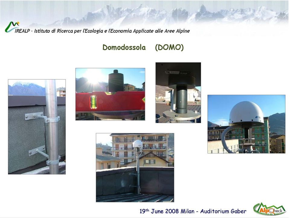
17 Domodossola (DOMO)
18 LENTA (LENT)

19 Mondovì (MONI)

20 Nizza Monferrato (NMON)

21 Santo Stefano Roero (ROER)
22 Mede (MELO)
23 Serravalle Scrivia (SESC)
24 Levelling
GNSS MONITORING NETWORKS
 SPACE GNSS MONITORING NETWORKS Satellite communications, earth observation, navigation and positioning and control stations indracompany.com GNSS MONITORING NETWORKS GNSS MONITORING NETWORKS Indra s solutions
Vehicle and Object Tracking Based on GPS and GSM
 Vehicle and Object Tracking Based on GPS and GSM 1 Sonali Kumari, 2 Simran Ghai, 3 Bharti Kushwaha 1,2,3 Department of Computer Science, Dronacharya Group of Institutions, Greater Noida (U.P), India Abstract:
Introduction into Real-Time Network Adjustment with Geo++ GNSMART
 Introduction into Real-Time Network Adjustment with Geo++ GNSMART Andreas Bagge Gerhard Wübbena, Martin Schmitz Geo++ GmbH D-30827 Garbsen, Germany www.geopp.de GeoInformation Workshop 2004, Istanbul Kultur
International Global Navigation Satellite Systems Service
 International Global Navigation Satellite Systems Service IGS Multi-GNSS Experiment IGS M-GEX Call for Participation www.igs.org Response to this Call for Participation in IGS M-GEX via Web Form Submission
Vehicle GPS Tracker GP268. GP268 Vehicle GPS/GPRS Tracking and Monitoring System Presentation July, 2009
 Vehicle GPS Tracker GP268 Winwill World Co., Ltd 2008 Website: www.winwillworld.com Inquire now: [email protected] - 1 - 1 PRODUCT INTRODUCTION 1.1 Features of unpacking 1.2 Brief introduction GP268,
3.4 SCS Technologies for Container Integrity: Track/Trace or Positioning technologies
 3.4 SCS Technologies for Container Integrity: Track/Trace or Positioning technologies It seems evident that if authorities are concerned about the potential misuse of containers by criminals or terrorists,
Remote Area Tracking and Mapping
 Remote Area Tracking and Mapping TM3000 with Iridium Satellite Back up Communications Step Global has developed a solution to remote area GPS tracking by interfacing the Trimble TM3000 Asset Tracking Device
How GPS works? WHAT IS GPS? HOW TRACKING WORKS?
 WHAT IS GPS? The Global Positioning System (GPS) is a satellite-based navigation system made up of a network of 24 satellites placed into orbit by the U.S. Department of Defense. GPS was originally intended
GEOGRAPHIC INFORMATION SYSTEMS Lecture 21: The Global Positioning System
 GEOGRAPHIC INFORMATION SYSTEMS Lecture 21: The Global Positioning System The Global Positioning System - recognize that GPS is only one of several Global Navigation Satellite Systems (GNSS) - the Russian
Post Processing Service
 Post Processing Service The delay of propagation of the signal due to the ionosphere is the main source of generation of positioning errors. This problem can be bypassed using a dual-frequency receivers
Global Positioning System (GPS) Automated Vehicle Location (AVL) Geographic Information System (GIS) and Routing/Scheduling System
 Automated Vehicle Location (AVL) Geographic Information System (GIS) and Routing/Scheduling System") Global Positioning System (GPS) Automated Vehicle Location (AVL) Geographic Information System (GIS) and Routing/Scheduling System Jeff Tsai Program Director Institute for Transportation Research and Education
Global Positioning System (GPS) Automated Vehicle Location (AVL) Geographic Information System (GIS) and Routing/Scheduling System Jeff Tsai Program Director Institute for Transportation Research and Education
INTRODUCTION TO GNSS NETWORK RTK. BAKU (AZERBAIDJAN) 12 Mai 2009. Ezzedine Djerbi Leica Geo-Systems Switzerland
 12 Mai 2009. Ezzedine Djerbi Leica Geo-Systems Switzerland") INTRODUCTION TO GNSS NETWORK RTK BAKU (AZERBAIDJAN) 12 Mai 2009 Ezzedine Djerbi Leica Geo-Systems Switzerland 1 GPS & GLONASS constellations have never been designed to serve the civilian applications
INTRODUCTION TO GNSS NETWORK RTK BAKU (AZERBAIDJAN) 12 Mai 2009 Ezzedine Djerbi Leica Geo-Systems Switzerland 1 GPS & GLONASS constellations have never been designed to serve the civilian applications
MCOM VEHICLE TRACKING SYSTEM MANUAL
 2012 MCOM VEHICLE TRACKING SYSTEM MANUAL Vehicle Tracking System allows the Department to track, trace and monitor their vehicles in real time using GSM / GPRS technology. It sends the location address,
GeoMax GNSS Zenith10 & Zenith20 Series
 GeoMax GNSS Zenith10 & Zenith20 Series GeoMax About Us At GeoMax we provide a comprehensive portfolio of integrated solutions by developing, manufacturing and distributing quality construction and surveying
Enabling RTK-like positioning offshore using the global VERIPOS GNSS network. Pieter Toor GNSS Technology Manager
 Enabling RTK-like positioning offshore using the global VERIPOS GNSS network Pieter Toor GNSS Technology Manager Introduction PPP/RTK Positioning Techniques PPP-AR Technology Presentation Overview PPP-AR
European best practices in safe transport of dangerous material supported by GNSS
 2 nd GNSS Vulnerabilities and Solutions 2009 Conference, Baska, Croatia European best practices in safe transport of dangerous material supported by GNSS Gianmarco Baldini IPSC - JRC EC Antonella Di Fazio
Smart Client Fleet Tracking Solutions By Steve Milroy & Pat Campbell OnTerra Systems LLC - http://www.onterrasys.com
 Smart Client Fleet Tracking Solutions By Steve Milroy & Pat Campbell OnTerra Systems LLC - http://www.onterrasys.com Traditionally, fleet tracking solutions also known as Automatic Vehicle Locator (AVL)
Global Navigation Satellite Systems
 White Paper Global Navigation Satellite Systems The Present and the Future For more information, please visit: 2012 IEIMobile Global Navigation Satellite System, or GNSS in short, is a generic term used
MCOM VEHICLE TRACKING SYSTEM MANUAL
 2015 MCOM VEHICLE TRACKING SYSTEM MANUAL Vehicle Tracking System allows the Department to track, trace and monitor their vehicles in real time using GSM / GPRS technology. It sends the location address,
Robot Perception Continued
 Robot Perception Continued 1 Visual Perception Visual Odometry Reconstruction Recognition CS 685 11 Range Sensing strategies Active range sensors Ultrasound Laser range sensor Slides adopted from Siegwart
The IGS: A Multi-GNSS Service
 The IGS: A Multi-GNSS Service Chris Rizos, Urs Hugentobler, Ruth Neilan IUGG IAG Structure International Union of Geodesy and Geophysics (IUGG) 65 Member Countries (Adhering Bodies), 8 Associations International
SAMA Tracking Solutions
 SAMA Tracking Solutions Vehicle Tracking System VTS SAMA Telecom 1 About SAMA Telecom SAMA TELECOM, is a leading company in telecommunication services, software application and system implementation. We
Bi-Directional DGPS for Range Safety Applications
 Bi-Directional DGPS for Range Safety Applications Ranjeet Shetty 234-A, Avionics Engineering Center, Russ College of Engineering and Technology, Ohio University Advisor: Dr. Chris Bartone Outline Background
siemens.com/tolling Back-office system Sitraffic Sensus Server Supplies all front-end data. Suitable for any GNSS tolling back-office.
 siemens.com/tolling Back-office system Server Supplies all front-end data. Suitable for any GNSS tolling back-office. Server: The universal back-office for efficient and effective toll collection Server
Real-Time Vehicle Tracking System [RKI-1660]
![Real-Time Vehicle Tracking System [RKI-1660]](/thumbs/25/5243224.jpg "Real-Time Vehicle Tracking System [RKI-1660]") Real-Time Vehicle Tracking System [RKI-1660] User Manual Robokits India [email protected] http://www.robokitsworld.com Page 1 Robokits India has partnered with Vehicleonmap.com to bring a Real-Time Vehicle
Real-Time Vehicle Tracking System [RKI-1660] User Manual Robokits India [email protected] http://www.robokitsworld.com Page 1 Robokits India has partnered with Vehicleonmap.com to bring a Real-Time Vehicle
Vehicle Tracking System,
 Vehicle Tracking System, The Complete Solution What is GPS? Product Review. Complete system. Contact Us. What is GPS? GPS, which stands for Global Positioning System, is the only system today able to show
The Applanix SmartBase TM Software for Improved Robustness, Accuracy, and Productivity of Mobile Mapping and Positioning
 The Applanix SmartBase TM Software for Improved Robustness, Accuracy, and Productivity of Mobile Mapping and Positioning Joe Hutton and Edith Roy, Applanix Corporation Introduction Applanix, along with
To facilitate the trials, MagicSBAS
 Vehicle tracking trial results for SBAS in South Africa Information from SANSA The SATSA (SBAS Awareness and Training for South Africa) project was established to facilitate SBAS (satellite based augmentation
MULTI-GNSS DEMONTRATION CAMPAIGN IN ASIA OCEANIA REGION
 UNITED NATIONS INTERNATIONAL MEETING ON THE APPLICATIONS OF GLOBAL NAVIGATION SATELLITE SYSTEMS PRESENTATION SESSION 2: INTERNATIONAL INITIATIVES/EXPERIENCES MULTI-GNSS DEMONTRATION CAMPAIGN IN ASIA OCEANIA
Smart Onboard Public Information System using GPS & GSM Integration for Public Transport
 Smart Onboard Public Information System using GPS & GSM Integration for Public Transport Mr. Prafull D. Patinge 1, Ms. N. R. Kolhare 2 ME, Electronics Engg. Dept. of Electronics and Telecommunication Engineering,
Vehicle GPS Tracker GP2068
 Vehicle GPS Tracker GP2068-1 - 1 PRODUCT INTRODUCTION 1.1 Features of unpacking 1.2 Brief introduction This newly launched vehicle GPS tracker-gp2068 is a GPRS based tracking system. It is for individual
The professional solution for web-enabled Fleet Management
 The professional solution for web-enabled Fleet Management February 2009 Cefin Systems The professional solution for web-enabled Fleet Management The solution to fit any mobility business Logical and functional
Hybrid positioning and CellLocate TM
 Hybrid positioning and CellLocate TM Increased reliability and indoor positioning based on mobile network attributes Dr. Chris Marshall, Visionary Program Manager, u-blox Carl Fenger, Communications Manager,
Prof. Ludovico Biagi. Satellite Navigation and Monitoring
 Prof. Ludovico Biagi Satellite Navigation and Monitoring Navigation: trajectories control positions estimations in real time, at high frequency popular applications: low accuracy (10 m) required specific
Satellite Asset Tracking and Fleet Management (SATFM) and SCADA. Presentation by: Dimov Stojce Ilcev DUT. CNS Systems
 and SCADA. Presentation by: Dimov Stojce Ilcev DUT. CNS Systems") Satellite Asset Tracking and Fleet Management (SATFM) and SCADA Presentation by: Dimov Stojce Ilcev DUT CNS Systems August 2011 SATELLITE OPERATORS Current Satellite Constellations Suitable for SATFM and
Satellite Asset Tracking and Fleet Management (SATFM) and SCADA Presentation by: Dimov Stojce Ilcev DUT CNS Systems August 2011 SATELLITE OPERATORS Current Satellite Constellations Suitable for SATFM and
Discrete Wireless MARCUS Product Overview
 Discrete Wireless MARCUS Product Overview Company Background Discrete Wireless, Inc. is a dynamic leader in GPS Fleet Management products and services. Discrete Wireless was incorporated May 12, 2000.
Real-time Vehicle Tracking System
 DEVICE USER MANUAL v2 http; WEB BASED TRACKING PORTAL INDEX Overview What s in the Box? Pin-out Interface LED Status Information SIM Card and Cellular Data Requirements Usage Steps Service and Support
Maintain Fleet Management Solutions Using Wide Area Wireless Technology
 Maintain Fleet Management Solutions Using Wide Area Wireless Technology Andreas Kohn Sierra Wireless, Inc. August, 2010 1 Introduction Wireless technology can provide a competitive advantage in today s
THE ACTIVITIES OF THE NATIONAL SPACE RESEARCH & DEVELOPMENT AGENCY,NIGERIA, IN THE AREA OF GLOBAL NAVIGATION SATELLITE SYSTEM (GNSS)
") THE ACTIVITIES OF THE NATIONAL SPACE RESEARCH & DEVELOPMENT AGENCY,NIGERIA, IN THE AREA OF GLOBAL NAVIGATION SATELLITE SYSTEM (GNSS) presented by: Nurudeen Suleiman Nigeria Communication Satellite Limited
THE ACTIVITIES OF THE NATIONAL SPACE RESEARCH & DEVELOPMENT AGENCY,NIGERIA, IN THE AREA OF GLOBAL NAVIGATION SATELLITE SYSTEM (GNSS) presented by: Nurudeen Suleiman Nigeria Communication Satellite Limited
Satellite-based navigation systems and their application in Kyrgyz Republic
 United Nations/United Arab Emirates/United States of America Workshop on the Applications of Global Navigation Satellite Systems Satellite-based navigation systems and their application in Kyrgyz Republic
Alberding precision agriculture solutions
 Alberding precision agriculture solutions Alberding GmbH AGRITECHNICA 2015, 8 14 November 2015, Hanover, Germany Presentation by: Tamás Horváth & Katrin Arendholz Alberding GmbH - Precision agriculture
Maritime Integrated PNT System
 Maritime Integrated PNT System Core element for safe ship navigation Evelin Engler und Thoralf Noack DLR Institut für Kommunikation und Navigation Folie 1 Maritime Integrated PNT System = overlay of satellite
Vehicle Scrutinizing using GPS & GSM Technologies Implemented with Ardunio controller
 Vehicle Scrutinizing using GPS & GSM Technologies Implemented with Ardunio controller A.Kalaiarasi 1, Raviram.P 2, Prabakaran. P M 3, ShanthoshKumar.K 4, Dheeraj B P 5 Assistant Professor, Dept. of EEE,
Günter Seeber. Satellite Geodesy 2nd completely revised and extended edition
 Günter Seeber Satellite Geodesy 2nd completely revised and extended edition Walter de Gruyter Berlin New York 2003 Contents Preface Abbreviations vii xvii 1 Introduction 1 1.1 Subject of Satellite Geodesy...
Blue & Me Fleet. Fleet management has never been so easy. Iveco S.p.A. Via Puglia, 35 10156 Turin - Italy www.iveco.com
 Iveco S.p.A. Via Puglia, 35 10156 Turin - Italy www.iveco.com Publication A082512 Printed in Italy September 2008 The information in this publication is provided purely as a guide and is not binding. Blue
Real-Time Car GPS Tracker (Portable, Weatherproof, Magnet, More)
") TK104 GPS Portable Asset Tracker Real-Time Car GPS Tracker (Portable, Weatherproof, Magnet, More) Product code: TK104 Real-Time Car GPS Tracker Meet the TK104. Our current top-of-the-line, heavy-duty GPS
TK104 GPS Portable Asset Tracker Real-Time Car GPS Tracker (Portable, Weatherproof, Magnet, More) Product code: TK104 Real-Time Car GPS Tracker Meet the TK104. Our current top-of-the-line, heavy-duty GPS
FLEET MANAGEMENT & CAR SECURITY SYSTEM GPRS/GPS
 FLEET MANAGEMENT & CAR SECURITY SYSTEM FOR PROVIDERS AND CUSTOMERS The Tracker Server Communication Program for data collection The Tracker Client Map Program intended for dispatching desks The GSM/GPRS
Presentation by: Dimov Stojce Ilcev DUT. CNS Systems. August 2011
 Satellite Asset Tracking (SAT) of Ships, Containers, Vehicles, Wagons and Aircraft Presentation by: Dimov Stojce Ilcev DUT CNS Systems August 2011 SATELLITE OPERATORS Current Satellite Constellations Suitable
GENERAL INFORMATION ON GNSS AUGMENTATION SYSTEMS
 GENERAL INFORMATION ON GNSS AUGMENTATION SYSTEMS 1. INTRODUCTION Navigation technologies with precision approach and landing systems, for civilian and military purposes, enable aircrafts to perform their
Leica AR25 White Paper
 Leica AR25 White Paper February 2009 Lennon Bedford, Neil Brown, Justin Walford Leica Geosystems AG Heerbrugg, Switzerland 2 Biography Lennon Bedford graduated from the University of Otago in 2003 with
GPS Tracking Solution GPS GSM Tracker
 2013 GPS Tracking Solution GPS GSM Tracker Robust solution for tracking your Assets, Cars, Buses, Trucks, Fleet, Shipment, Children, Pets and more with web based tracking from anywhere in the world through
European Position Determination System. Guidelines For Cross- Border Data Exchange
 European Position Determination System Guidelines For Cross- Border Data Exchange Version 1.0 21 September 2006 Copyright: Publisher: 2007 by the International EUPOS Steering Committee Office of the International
NAVICOM DYNAMICS RTK BASE STATION INSTALLATION AND COMMISSIONING INSTRUCTIONS
 NAVICOM DYNAMICS RTK BASE STATION INSTALLATION AND COMMISSIONING INSTRUCTIONS 1. Locate a suitable position inside the building to install the Base Station enclosure where mains power (240V AC) is available
HEOL-N103-OBD, GPS/GPRS Tracking Module with On Board Diagnostic
 HEOL-N103-OBD, GPS/GPRS Tracking Module with On Board Diagnostic Heol fleet tracking system GPS N103 -OBD GPRS FTS Software Internet Main office - Control room Other office The specifications in this document
An Innovative Concept to Manage GPS Reference Stations Network and RTK Data Distribution Globally
 An Innovative Concept to Manage GPS Reference Stations Network and RTK Data Distribution Vincent LUI, Hong Kong SAR, China Key words: GPS reference station network, Internet, Spider, data management, integrity
Alberding DGNSS solutions for inland waterways
 Alberding DGNSS solutions for inland waterways December 2012 1/29 Alberding DGNSS solutions for inland waterways Tamás Horváth Alberding GmbH DISC 12 Vukovar 13 December 2012 Alberding DGNSS solutions
GPS Based Automatic Vehicle Tracking Using RFID Devyani Bajaj, Neelesh Gupta [email protected]
 GPS Based Automatic Vehicle Tracking Using RFID Devyani Bajaj, Neelesh Gupta [email protected] Abstract a vehicle tracking system is an electronic device installed in a vehicle to enable the owner
Legislative Council Panel on Information Technology and Broadcasting. Information Note on the Development of Global Positioning System in Hong Kong
 CB(1)1709/03-04(01) Legislative Council Panel on Information Technology and Broadcasting Information Note on the Development of Global Positioning System in Hong Kong PURPOSE At the meeting of the Panel
Advanced Vehicle Tracking System on Google Earth Using GPS and GSM
 IJECT Vo l. 5, Is s u e Sp l - 3, Ja n - Ma r c h 2014 ISSN : 2230-7109 (Online) ISSN : 2230-9543 (Print) Advanced Vehicle Tracking System on Google Earth Using GPS and GSM 1 Sowjanya Kotte, 2 Hima Bindhu
MANAGEMENT SYSTEM FOR A FLEET OF VEHICLES BASED ON GPS. João André Correia Telo de Oliveira
 MANAGEMENT SYSTEM FOR A FLEET OF VEHICLES BASED ON GPS João André Correia Telo de Oliveira Author Affiliation(s) Instituto Superior Técnico, University of Lisbon, Portugal ABSTRACT This dissertation was
u-blox comprehensive approach to multi-gnss positioning
 WHITEPAPER u-blox comprehensive approach to multi-gnss positioning locate, communicate, accelerate Whitepaper by: Carl Fenger, Communications Manager, u-blox Uffe Pless, Product Manager, u-blox May 2012
VEHICLE TRACKING SYSTEM USING GPS. 1 Student, ME (IT) Pursuing, SCOE, Vadgaon, Pune. 2 Asst. Professor, SCOE, Vadgaon, Pune
 Pursuing, SCOE, Vadgaon, Pune. 2 Asst. Professor, SCOE, Vadgaon, Pune") VEHICLE TRACKING SYSTEM USING GPS Pooja P. Dehankar 1, 1 Student, ME (IT) Pursuing, SCOE, Vadgaon, Pune Prof. S. P. Potdar 2 2 Asst. Professor, SCOE, Vadgaon, Pune Abstract- Global Positioning System is
VEHICLE TRACKING SYSTEM USING GPS Pooja P. Dehankar 1, 1 Student, ME (IT) Pursuing, SCOE, Vadgaon, Pune Prof. S. P. Potdar 2 2 Asst. Professor, SCOE, Vadgaon, Pune Abstract- Global Positioning System is
Integrating GPS, GSM and Cellular Phone for Location Tracking and Monitoring
 Proceedings of the International Conference on Geospatial Technologies and Applications, Geomatrix 12 February 26 29, 2012, IIT Bombay, Mumbai, India Integrating GPS, GSM and Cellular Phone for Location
General GPS Antenna Information APPLICATION NOTE
 General GPS Antenna Information APPLICATION NOTE General GPS Antenna Information Global Positioning System and Precise Time & Frequency The Global Positioning System (GPS) is a worldwide radio-navigation
Location Based Services for Enterprise
 Location Based Services for Enterprise Introduction WHITEPAPER Location Based Services (LBS) have been making foray into enterprise applications, thanks to the rise in smartphone ownership and the phenomenal
Global Positioning System
 B. Hofmann-Wellenhof, H. Lichtenegger, and J. Collins Global Positioning System Theory and Practice Third, revised edition Springer-Verlag Wien New York Contents Abbreviations Numerical constants xix xxiii
1.1 OVERVIEW OF THE DOCUMENT 1.2 BACKGROUND TO THE PROJECT
 CHAPTER 1 INTRODUCTION 1.1 OVERVIEW OF THE DOCUMENT This project thesis examines the task of learning to develop a cost-effective vehicle movement tracking system for companies to track their vehicles.
Localisation and tracking solution of dangerous goods transport
 CORE Supply Chain Forum Antwerp, 24 September 2015 Localisation and tracking solution of dangerous goods transport Antonella Di Fazio, Telespazio SPA, Italy CORE Supply Chain Forum, Antwerp, 24 September
Overview of BeiDou/GPS Applied in Road Transportation Li Jing China Transport Telecommunication & Information Center(CTTIC) Ministry of Transport of
 Ministry of Transport of") Overview of BeiDou/GPS Applied in Road Transportation Li Jing China Transport Telecommunication & Information Center(CTTIC) Ministry of Transport of the People s Republic of China ICG 7 11/5/2012 1 Current
Overview of BeiDou/GPS Applied in Road Transportation Li Jing China Transport Telecommunication & Information Center(CTTIC) Ministry of Transport of the People s Republic of China ICG 7 11/5/2012 1 Current
Satellite Tracking System FindMe F2
 Satellite Tracking System FindMe F2 1 FindMe F2 SATELLITE TRACKING SYSTEM PRIMARY FUNCTION To determine and to transmit to a user exact LBS and GPS/GLONASS position of a stolen or lost vehicle, valuable
GNSS Scenario. By Dr Ashok Kaushal. GNSS scenario in India in India. 05/08/2007 Slide No.: 1
 GNSS Scenario in India By Dr Ashok Kaushal ASL 1 Advanced Systems Pvt. Aerospace Ltd., Systems Bangalore Pvt. Ltd. Slide No.: 1 Content Introduction Significance of Location Trends G 3 perspective Location
Leica GR25 Don t think Receiver, think Reference Server
 Leica GR25 Don t think Receiver, think Reference Server Leica GR25 GNSS Reference Server Think Reference Server The GR25 is more than just a reference receiver, it is a GNSS Reference Server. Just like
INTEGRITY AND CONTINUITY ANALYSIS OCTOBER TO DECEMBER 2013 QUARTERLY REPORT FROM GPS. Integrity and Continuity Analysis 08/01/14 08/01/14 08/01/14
 INTEGRITY AND CONTINUITY ANALYSIS FROM GPS OCTOBER TO DECEMBER 2013 QUARTERLY REPORT Prepared by: M Pattinson (NSL) 08/01/14 Checked by: L Banfield (NSL) 08/01/14 Approved by: M Dumville (NSL) 08/01/14
1. Vehicle Security/Tracking Device
 GPS Vehicle Tracking Devices 1. Vehicle Security/Tracking Device The size of a pack of cigarettes, the SuperGuardreports to you directly with alarm details and GPS location through SMS text messaging and
Vehicle Tracking System using GPS and Android OS
 Vehicle Tracking System using GPS and Android OS Amol Dhumal, Amol Naikoji, Yutika Patwa, Manali Shilimkar, Prof. M. K. Nighot Abstract In today s era everyone is using mobile phones for communication.
Comparative Analysis of Several Real-Time Systems for Tracking People and/or Moving Objects using GPS
 Comparative Analysis of Several Real-Time Systems for Tracking People and/or Moving Objects using GPS Gligorcho Radinski and Aleksandra Mileva University Goce Delčev, Faculty of Computer Science Krste
The European GNSS Programmes EGNOS and Galileo
 The European GNSS Programmes EGNOS and Galileo 6th ICG Conference Pieter De Smet European Commission 5 September 2011 1. State of Play of EGNOS 2. State of Play of Galileo 5 September, 2011 The European
Fleet Tracking System
 Improve Customer Service Quality with a GPS Fleet Tracking System WHITEPAPER Improve Customer Service Quality with a GPS Fleet Tracking System ABOUT TECHNO BRAIN Techno Brain is the leading IT Solutions,
How To Track A Vehicle With A Smart Vehicle Tracking System
 SMART VEHICLE TRACKING SYSTEM Mrs. K.P.Kamble 1 Lecturer 1 Department of Electronics and Telecommunication Engineering, YCCE, Nagpur [email protected] ABSTRACT It is amazing to know how simple
GPSintegrated - GPS Tracking Platform
 GPSintegrated - GPS Tracking Platform Cloud based GPS Tracking platform used in over 25 countries for real-time tracking of People, Cars, Fleet & Assets using GPS trackers & Mobile Apps. We are your one
Safety Applications for GPS Systems in the Mining Industry
 Safety Applications for GPS Systems in the Mining Industry Introduction The Global Positioning System (GPS) has been available for civilian use for more than 20 years now. It has found many navigation,
SONOBOT AUTONOMOUS HYDROGRAPHIC SURVEY VEHICLE PRODUCT INFORMATION GUIDE
 SONOBOT AUTONOMOUS HYDROGRAPHIC SURVEY VEHICLE PRODUCT INFORMATION GUIDE EvoLogics SONOBOT: Autonomous Surface Vehicle for Hydrographic Surveys High Precision Differential GPS for high-accuracy cartography
Perspective of Permanent Reference Network KOPOS in Kosova
 143 Perspective of Permanent Reference Network KOPOS in Kosova Meha, M. and Çaka, M. Kosovo Cadastral Agency, Kosovo Archive Building II nd floor, P.O. 10000, Prishtina, Republic of Kosovo, E-mail: [email protected],
Using Mobiles for On Campus Location Tracking
 Using Mobiles for On Campus Location Tracking F. Aloul A. Sagahyroon A. Al-Shami I. Al-Midfa R. Moutassem American University of Sharjah P.O. Box 26666, Sharjah, UAE {faloul, asagahyroon, b00020906, b00020142,
Evaluation for Cargo Tracking Systems in Railroad Transportation
 INTERNATIONAL FORUM ON SHIPPING PORTS AND AIRPORTS Evaluation for Cargo Tracking Systems in Railroad Transportation N.K.Park Tongmyung Univ CONTENTS INTRODUTION BASIC RESEARCH REVIEW THE RAILWAY TRACKING
A fool proof Fleet Management System
 A fool proof Fleet Management System for your business providing complete fleet management with customised solutions that not only ensure the safety of your goods, vehicles and personnel, but also enhances
FUTURE TRENDS AND OPPORTUNITIES IN CEMENT TRANSPORT
 Mahindra Outperformer s League (OPL) FUTURE TRENDS AND OPPORTUNITIES IN CEMENT TRANSPORT Presentation Sequence Stake Holders Challenges Cement Logistics Future Trends Value Proposition Logistics Eco System
Absolute GNSS Antenna Calibration with a Robot: Repeatability, GLONASS and Carrier-to-Noise Pattern
 Absolute GNSS Antenna Calibration with a Robot: Repeatability, GLONASS and Carrier-to-Noise Pattern Gerhard Wübbena, Martin Schmitz, Gerald Boettcher Geo++ GmbH 30827 Garbsen Germany www.geopp.com Content
GPS/SMS/GPRS TRACKER TK103A VEHICLE CAR REALTIME TRACKING DEVICE SYSTEM
 GPS/SMS/GPRS TRACKER TK103A VEHICLE CAR REALTIME TRACKING DEVICE SYSTEM This GPS Tracker was specially made for vehicles. It's a new product based on the GSM/GPRS (850, 900, 1800, 1900MHz) network and