2.6 RAINFALL MONITORING NETWORK IN THE AMAZONIAN JUNGLE
|
|
|
- Phillip Russell
- 10 years ago
- Views:
Transcription
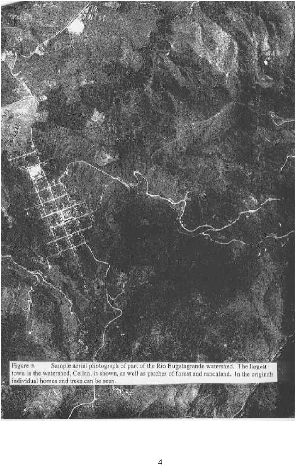
1 2.6 RAINFALL MONITORING NETWORK IN THE AMAZONIAN JUNGLE Bernhard Lee Lindner* College of Charleston, Charleston SC Carlos Arturo Delvasto Fundacion Rio Bugalagrande, Tulua, Colombia 1. INTRODUCTION Our team has set up a network of a dozen rain gauges monitoring climatic change in rainfall (both natural and man-made) in a small region within the Amazon basin where deforestation is occurring (see Figure 1). Our hypothesis is that a reduction in vegetation should lower evapotranspiration rates, which would probably lead to a reduction in atmospheric water vapor. This in turn may lead to a measurable change in cloud and rainfall parameters. Our network of rain gauges have provided and are continuing to provide hard in-situ data which are utilized in conjunction with remote sensing measurements of cloud cover and rainfall that are being made with satellite instrumentation, notably from the Tropical Rainfall Measuring Mission (TRMM). 2. RIO BUGALAGRANDE The rain gauges were set up on the Fundacion Rio Bugalagrande (FCB), 2300 hectares of private reserves interspersed in a mountainous region on approximately 40 kilometers by 20 kilometers of government-owned forest and private farms from the broad, low-lying valley (approximately 900m elevation) to the 3800m mountain tops (the treeline is at approximately 3500m). An elevation map of the Rio Bugalagrande watershed is shown in Figure 2. It is located near the village of Tulua, an hour north of Cali, Colombia and several hours from the coast (Latitude 4 degrees 5 minutes and 16 seconds North; Longitude 76 degrees 12 minutes and 0 seconds West). Most of this large watershed is natural forest, but small villages do exist in these mountains, and significant deforestation is occurring. The FCB is part of an effort to understand how Colombians are impacting their environment. Using private and public funds, the FCB has been purchasing deforested land and setting up reserves for reforestation. The FCB is also heavily involved in public outreach, teaching the farmers in the watershed about the appropriate crops to plant and about sustainable development of the area. 3. RAIN GAUGE MONITORING Assistance in placing and monitoring these rain gauges was received from dozens of local inhabitants, including forest rangers, university students, several teachers at public schools, and several employees of various governmental agencies who either work or live in this region. Each of the team members travel to their assigned rain gauges on a daily basis to record the amount of rainfall, note any compromising effects which might have influenced the collection (particularly human disturbance and bird feces), and empty the rain gauges. They also make notations of where burning is occurring and to what extent. I ensured that the rain gauge network was properly placed (proper height, far from obstructions, adequate spacing, etc.) and that the data collection process is done properly. I also toured the region (to the extent allowed; guerilla activity is fierce in this region), to examine how virgin and dense the rainforest is (assists with estimating the extent of evapotranspiration), to study the topography of the region (upslopes enhance rainfall, hence topographical effects need to be subtracted to look for deforestation effects), to examine the rate and manner of burning going on (burning contributes to cloud condensation nuclei) and to examine the characteristics of the villages and the people within them (how extensive, how forested, etc.). 1

2 4. ELEVATION AND VEGETATION The FCB provided detailed elevation and vegetation maps of the entire region, clearly showing the rivers and all the tributaries in the region, which is essential for comparison to satellite imagery because very few roads exist in the region for landmarks. These maps show not only the regions where deforestation has occurred, but also the type of vegetation in different parts of the watershed (essential for estimating evapotranspiration rates) and the ages (and hence heights) of regions where reforestation has begun (again essential for estimating evapotranspiration). Additionally, aerial photography shows the state of deforestation at the start of the project (see Figure 3), which will be useful when the project is completed. 5. OTHER NETWORKS In addition, we receive cooperation from members of the governmental agencies Corpocuencas, CVC and EPSA; all of whom currently collect precipitation data in more inhabited areas around the Rio Bugalagrande watershed, utilizing excellent equipment and methodology. Corpocuencas is the national agency responsible for managing all of the watersheds in Colombia. CVC is the national agency responsible for natural resources, and EPSA is the national power-regulating agency. While none of these agencies have rain gauges in the Rio Bugalagrande watershed, all these agencies have collected data nearby for decades, allowing an examination of long-term change in the region. Finally, several owners of some of the large ranches who have their own rain gauges in the wide valley below the Rio Bugalagrande watershed are providing their data to us. Some of these ranches have remarkably good equipment, which is understandable considering how important rainfall is to their livelihood. Again this data will be useful in examining the long-term data I will receive. 6. PARTNERS OF THE AMERICAS Support for this project was also provided from the South Carolina Chapter of Partners of the Americas (POA), an international, nonprofit, volunteer nongovernmental organization based in Washington, D.C. Since 1972, the South Carolina chapter of POA has been a partner with Southwestern Colombia, seeking to improve relations between Americans and Latin Americans through privately sponsored projects for mutual social and economic development. The chapter offices in South Carolina, and in Cali, Colombia were both extremely helpful in setting up the necessary contacts as well as local travel arrangements. For more information of the national organization, consult: For additional information on the local chapter, see: 7. SATELLITE DATA ANALYSIS In addition to the in-situ studies in South American jungles, satellite data analysis is taking place in the College of Charleston Weather Center. The College of Charleston Weather Center recently received a Unidata Software License, allowing access to a plethora of real-time NOAA satellite data. Data from the Tropical Rainfall Measurement Mission has been particularly useful. * Corresponding author address: B. Lee Lindner, Physics and Astronomy Department, College of Charleston, Charleston, SC 29424; [email protected] 1
 of regions where reforestation has begun (again essential for estimating evapotranspiration).")
3 2

4 3

5 4
Overview of NASA Applied Remote Sensing Training Program on Water Resources and Disaster Management
 Overview of NASA Applied Remote Sensing Training Program on Water Resources and Disaster Management ARSET Applied Remote SEnsing Training A project of NASA Applied Sciences Outline About ARSET ARSET Trainings
Flood Zone Investigation by using Satellite and Aerial Imagery
 Flood Zone Investigation by using Satellite and Aerial Imagery Younes Daneshbod Islamic Azad University-Arsanjan branch Daneshgah Boulevard, Islamid Azad University, Arsnjan, Iran Email: [email protected]
Welcome to NASA Applied Remote Sensing Training (ARSET) Webinar Series
 Webinar Series") Welcome to NASA Applied Remote Sensing Training (ARSET) Webinar Series Introduction to Remote Sensing Data for Water Resources Management Course Dates: October 17, 24, 31 November 7, 14 Time: 8-9 a.m.
Welcome to NASA Applied Remote Sensing Training (ARSET) Webinar Series Introduction to Remote Sensing Data for Water Resources Management Course Dates: October 17, 24, 31 November 7, 14 Time: 8-9 a.m.
Create Your Own Soil Profile Ac5vity
 Create Your Own Soil Profile Ac5vity Middle School: 5-8 Task Overview: Soil profile refers to layers of soil. A typical soil profile takes nearly 1,000 to 100,000 years to form. The formation of the soil
Correlation Analysis of Factors Influencing Changes in Land Use in the Lower Songkhram River Basin, the Northeast of Thailand
 Correlation Analysis of Factors Influencing Changes in Land Use in the Lower Songkhram River Basin, the Northeast of Thailand Rasamee SUWANWERAKAMTORN and Chat CHANTHALUECHA Geo-informatics Centre for
Rainforest Concern Module 2 Why do we need rainforests?
 Rainforest Concern Module 2 Why do we need rainforests? Rainforest Concern Module 2: Why do we need Rainforest? Before we go any further, there are some words you may not understand, and these words and
Ranger Report About Tropical Rainforest (in Costa Rica)
") 1. Ranger Report About Tropical Rainforest (in Costa Rica) www. Therainforestrangers.com About Rainforest Images by Jan Dwire A rainforest is an environment that receives high rainfall and is dominated
1. Ranger Report About Tropical Rainforest (in Costa Rica) www. Therainforestrangers.com About Rainforest Images by Jan Dwire A rainforest is an environment that receives high rainfall and is dominated
Tennessee Watershed Modeling Tools. Southern Region Watershed Meeting, July 2005. Forbes Walker University of Tennessee Extension
 Tennessee Watershed Modeling Tools Southern Region Watershed Meeting, July 2005 Forbes Walker University of Tennessee Extension Outline Land Use and Water Quality in Tennessee Watershed models Watershed
Abaya-Chamo Lakes Physical and Water Resources Characteristics, including Scenarios and Impacts
 LARS 2007 Catchment and Lake Research Abaya-Chamo Lakes Physical and Water Resources Characteristics, including Scenarios and Impacts Seleshi Bekele Awulachew International Water Management Institute Introduction
6. Base your answer to the following question on the graph below, which shows the average monthly temperature of two cities A and B.
 1. Which single factor generally has the greatest effect on the climate of an area on the Earth's surface? 1) the distance from the Equator 2) the extent of vegetative cover 3) the degrees of longitude
Madagascar: Makira REDD+
 project focus Madagascar: Makira REDD+ Madagascar is considered to be one of the top five biodiversity hotspots in the world due to more than 75% of all animal and plant species being endemic while less
Physiography, Geography and Climate of Latin America (Lecture 3)
") Physiography, Geography and Climate of Latin America (Lecture 3) Natural Landmarks in Latin America World's longest and second highest mountain range, and the world's highest active volcanoes. Biggest
Physiography, Geography and Climate of Latin America (Lecture 3) Natural Landmarks in Latin America World's longest and second highest mountain range, and the world's highest active volcanoes. Biggest
Studying Topography, Orographic Rainfall, and Ecosystems (STORE)
") Studying Topography, Orographic Rainfall, and Ecosystems (STORE) Introduction Basic Lesson 2: Using ArcGIS Explorer to Analyze the Connection between Topography and Rainfall This lesson introduces Geographical
Studying Topography, Orographic Rainfall, and Ecosystems (STORE) Introduction Basic Lesson 2: Using ArcGIS Explorer to Analyze the Connection between Topography and Rainfall This lesson introduces Geographical
Stage 4. Geography. Blackline Masters. By Karen Devine
 1 Devine Educational Consultancy Services Stage 4 Geography Blackline Masters By Karen Devine Updated January 2010 2 This book is intended for the exclusive use in NSW Secondary Schools. It is meant to
By Gerald Urquhart, Walter Chomentowski, David Skole, and Chris Barber http://earthobservatory.nasa.gov/library/deforestation/
 By Gerald Urquhart, Walter Chomentowski, David Skole, and Chris Barber http://earthobservatory.nasa.gov/library/deforestation/ The clearing of tropical forests across the Earth has been occurring on a
Pasture, Rangeland, and Forage Insurance: A Risk Management Tool for Hay and Livestock Producers
 October 2012 Pasture, Rangeland, and Forage Insurance: A Risk Management Tool for Hay and Livestock Producers Monte Vandeveer, Otoe County Extension Educator University of Nebraska-Lincoln Institute of
THE ECOSYSTEM - Biomes
 Biomes The Ecosystem - Biomes Side 2 THE ECOSYSTEM - Biomes By the end of this topic you should be able to:- SYLLABUS STATEMENT ASSESSMENT STATEMENT CHECK NOTES 2.4 BIOMES 2.4.1 Define the term biome.
SHAPING LAND-USE PRACTICES AND SUPPLY CHAINS THROUGH COMMODITY CERTIFICATION: THE EXPERIENCE OF THE RAINFOREST ALLIANCE
 SHAPING LAND-USE PRACTICES AND SUPPLY CHAINS THROUGH COMMODITY CERTIFICATION: THE EXPERIENCE OF THE RAINFOREST ALLIANCE Jeffrey Milder, Rainforest Alliance GEF/STAP Mainstreaming Biodiversity Workshop
CLIMATE, WATER & LIVING PATTERNS THINGS
 CLIMATE, WATER & LIVING PATTERNS NAME THE SIX MAJOR CLIMATE REGIONS DESCRIBE EACH CLIMATE REGION TELL THE FIVE FACTORS THAT AFFECT CLIMATE EXPLAIN HOW THOSE FACTORS AFFECT CLIMATE DESCRIBE HOW CLIMATES
Grades 3-5. Benchmark A: Use map elements or coordinates to locate physical and human features of North America.
 Grades 3-5 Students use knowledge of geographic locations, patterns and processes to show the interrelationship between the physical environment and human activity, and to explain the interactions that
Agriculture, Food Security and Climate Change A Triple Win?
 Agriculture, Food Security and Climate Change A Triple Win? Dr. Andrew Steer Special Envoy for Climate Change The World Bank Group Your Royal Highnesses, Excellencies, Ladies and Gentlemen, Let me begin
Water from the Air: Cloud Forests
 Water from the Air: Cloud Forests Alden Wicker Water from the Air: Cloud Forests In the Americas, Asia, and Africa, there s a special kind of forest. It s rare, beautiful, and incredibly important to the
Deforestation in the Amazon
 Deforestation in the Amazon By Rhett A Butler Rainforests once covered 14% of the earth's land surface; now they cover a mere 6% and experts estimate that the last remaining rainforests could be consumed
2013 Annual Climate Summary for the Southeast United States
 Months of heavy rain forced the U.S. Army Corp of Engineers to open the spillways at Lake Hartwell, located at the headwaters of the Savannah River along the South Carolina-Georgia border, on July 9,.
Forests and Water: A Policy Perspective
 Forests and Water: A Policy Perspective David Kaimowitz Center for International Forestry Research (CIFOR) P.O. Box 6596 JKPWB Jakarta 10065 Indonesia telephone: 62-251-622622 fax: 62-251-622100 [email protected]
THE GEORGIA AUTOMATED ENVIRONMENTAL MONITORING NETWORK: TEN YEARS OF WEATHER INFORMATION FOR WATER RESOURCES MANAGEMENT
 THE GEORGIA AUTOMATED ENVIRONMENTAL MONITORING NETWORK: TEN YEARS OF WEATHER INFORMATION FOR WATER RESOURCES MANAGEMENT Gerrit Hoogenboom, D.D. Coker, J.M. Edenfield, D.M. Evans and C. Fang AUTHORS: Department
APPLICATION OF GOOGLE EARTH FOR THE DEVELOPMENT OF BASE MAP IN THE CASE OF GISH ABBAY SEKELA, AMHARA STATE, ETHIOPIA
 APPLICATION OF GOOGLE EARTH FOR THE DEVELOPMENT OF BASE MAP IN THE CASE OF GISH ABBAY SEKELA, AMHARA STATE, ETHIOPIA Abineh Tilahun Department of Geography and environmental studies, Adigrat University,
Environmental Data Services for Delaware:
 Environmental Data Services for Delaware: Serving Emergency Responders, Planners, and Researchers Network Delaware Day November 6, 2013 Overview Operational Data Services More than just research DEOS and
Range Management Databases on the Web: Two Examples
 Range Management Databases on the Web: Two Examples George Ruyle, Chair, Rangeland & Forest Research Program, School of Renewable Natural Resources, Biological Sciences East 302, University of Arizona,
Ecosystems. The two main ecosystem processes: Energy flow and Chemical cycling
 Ecosystems THE REALM OF ECOLOGY Biosphere An island ecosystem A desert spring ecosystem Biosphere Ecosystem Ecology: Interactions between the species in a given habitat and their physical environment.
Forecast-Informed Reservoir Operations: A Concept Supporting Water Supply and Flood Control
 16 inches of rain in 1 day in Central California Forecast-Informed Reservoir Operations: A Concept Supporting Water Supply and Flood Control Developed by the Center for Western Weather and Water Extremes
Ecological Restoration Strategies for Cattle Ranching Landscapes of the Azuero
 COURSE REPORT Ecological Restoration Strategies for Cattle Ranching Landscapes of the Azuero District of Pedasi, Province of Los Santos July 27-31, 2015 A field course organized by: The Environmental Leadership
Regional Atlas: Introduction to South Asia
 Name Regional Atlas: Introduction to South Asia Study the map on page 593 of the textbook. 1. The Khyber Pass connects which two countries? CHAPTER 28 2. What capital city is located at 80 E longitude?
Earth Science & Environmental Science SOL
 Earth Science & Environmental Science SOL THE SOL FOR GRADE 6 The Virginia Science SOL for Grades K 6 are organized according to a set of strands, with the SOL in each strand developed progressively through
Ranger Report About Deforestation of the Rainforest
 Ranger Report About Deforestation of the Rainforest About deforestation Forests are cut down for many reasons, but most of them are related to money or to people s need to provide for their families. The
Clouds and the Energy Cycle
 August 1999 NF-207 The Earth Science Enterprise Series These articles discuss Earth's many dynamic processes and their interactions Clouds and the Energy Cycle he study of clouds, where they occur, and
CGC1D1: Interactions in the Physical Environment Factors that Affect Climate
 Name: Date: Day/Period: CGC1D1: Interactions in the Physical Environment Factors that Affect Climate Chapter 12 in the Making Connections textbook deals with Climate Connections. Use pages 127-144 to fill
Glaciogenic Cloud Seeding to Increase Orographic Precipitation Bruce A. Boe [email protected] Director of Meteorology
 Glaciogenic Cloud Seeding to Increase Orographic Precipitation Bruce A. Boe [email protected] Director of Meteorology Weather Modification, Inc. Fargo, North Dakota, USA www.weathermodification.com Content
Doing Business, Small & Medium Enterprise Support and Information Access
 Doing Business, Small & Medium Enterprise Support and Information Access Vietnam, a nation of 92 million people, aspires to be more fully integrated into the global economy and community and an industrialized
JOB DESCRIPTION. Policy Advisor (campaigner)
") JOB DESCRIPTION Policy Advisor (campaigner) Effective from: January 2016 Reporting to: Research and Policy Coordinator Close working relationship with: Executive Director, Head of Programmes, Research
JOB DESCRIPTION Policy Advisor (campaigner) Effective from: January 2016 Reporting to: Research and Policy Coordinator Close working relationship with: Executive Director, Head of Programmes, Research
Flash Flood Science. Chapter 2. What Is in This Chapter? Flash Flood Processes
 Chapter 2 Flash Flood Science A flash flood is generally defined as a rapid onset flood of short duration with a relatively high peak discharge (World Meteorological Organization). The American Meteorological
Titelmasterformat durch Klicken. bearbeiten
 Evaluation of a Fully Coupled Atmospheric Hydrological Modeling System for the Sissili Watershed in the West African Sudanian Savannah Titelmasterformat durch Klicken June, 11, 2014 1 st European Fully
Project Theory-Climate Change and Traditional Ecological Knowledge Adaption in the Klamath Basin
 Project Theory-Climate Change and Traditional Ecological Knowledge Adaption in the Klamath Basin Frank K. Lake Lead Science and TEK Mentor for project Education 1995 B.S. University of California, Davis.
INTEGRATED NATIONAL ADAPTATION PILOT República de Colombia INAP
 INTEGRATED NATIONAL ADAPTATION PILOT INAP Ecosystem Based Adaptation High Mountain Ecosystems Angela Andrade Technical Coordinator INAP Klaus Schutze Páez Coordinator Comp B CLIMATE CHANGE IN COLOMBIA
CLIMATE OF RWANDA. Overview. Linked to other lessons
 Geography S6 GENERAL PHYSICAL GEOGRAPHY OF RWANDA Lesson 75 Developed by (Niwagaba Innocent) Subtopic Climate and factors influencing it in Rwanda Specific Objectives The learners must be able to: Describe
China Protected Areas Leadership Alliance Project
 Strengthening Leadership Capacity for Effective Management of China s Protected Areas Executive Summary The (CPALAP) is a multi-year initiative launched in 2008 under a partnership between the China State
Basic Climatological Station Metadata Current status. Metadata compiled: 30 JAN 2008. Synoptic Network, Reference Climate Stations
 Station: CAPE OTWAY LIGHTHOUSE Bureau of Meteorology station number: Bureau of Meteorology district name: West Coast State: VIC World Meteorological Organization number: Identification: YCTY Basic Climatological
DEVELOPING FLOOD VULNERABILITY MAP FOR NORTH KOREA INTROUDUCTION
 DEVELOPING FLOOD VULNERABILITY MAP FOR NORTH KOREA Soojeong Myeong, Research Fellow Hyun Jung Hong, Researcher Korea Environment Institute Seoul, South Korea 122-706 [email protected] [email protected]
PRECIPITATION AND EVAPORATION
 PRECIPITATION AND EVAPORATION OBJECTIVES Use historical data to analyze relationships between precipitation, evaporation and stream flow in the San Antonio River Basin TOPICS Water cycle Precipitation
WEPP MODEL APPLICATIONS FOR EVALUATIONS OF BEST MANAGEMENT PRACTICES
 WEPP MODEL APPLICATIONS FOR EVALUATIONS OF BEST MANAGEMENT PRACTICES D.C. FLANAGAN 1, W.J. ELLIOT 2, J.R. FRANKENBERGER 3, C. HUANG 4 1 USDA-Agricultural Research Service, National Soil Erosion Research
7613-1 - Page 1. Weather Unit Exam Pre-Test Questions
 Weather Unit Exam Pre-Test Questions 7613-1 - Page 1 Name: 1) Equal quantities of water are placed in four uncovered containers with different shapes and left on a table at room temperature. From which
LAND USE, LAND COVER AND SOIL SCIENCES Vol. V Desertification and Deforestation in Africa - R. Penny DESERTIFICATION AND DEFORESTATION IN AFRICA
 DESERTIFICATION AND DEFORESTATION IN AFRICA R. Penny Environmental and Developmental Consultant/Practitioner, Cape Town, South Africa Keywords: arid, semi-arid, dry sub-humid, drought, drylands, land degradation,
Real Time Flood Alert System (RTFAS) for Puerto Rico
 for Puerto Rico") Prepared in cooperation with the Puerto Rico Emergency Management Agency (PREMA) Real Time Flood Alert System (RTFAS) for Puerto Rico Overview The Real Time Flood Alert System is a web-based computer program,
Prepared in cooperation with the Puerto Rico Emergency Management Agency (PREMA) Real Time Flood Alert System (RTFAS) for Puerto Rico Overview The Real Time Flood Alert System is a web-based computer program,
Short title: The PES Experience in Costa Rica, Colombia and Nicaragua.
 Regional Integrated Silvopastoral Ecosystem Management Project Costa Rica, Colombia and Nicaragua Authors: Stefano Pagiola and Agustin Arcenas Short title: The PES Experience in Costa Rica, Colombia and
Global Flood Alert System (GFAS)
") An Introduction of Global Flood Alert System (GFAS) Kazuo UMEDA Director of 2 nd Research Department, Infrastructure Development Institute-JAPAN Target: Reduction of Human Loss World s s natural disaster
An Introduction of Global Flood Alert System (GFAS) Kazuo UMEDA Director of 2 nd Research Department, Infrastructure Development Institute-JAPAN Target: Reduction of Human Loss World s s natural disaster
Content Guide & Five Items Resource
 Content Guide & Five Items Resource Introduction The following information should be used as a companion to the CPI Links. It provides clarifications concerning the content and skills contained in the
Physical Environment. There are economic reasons for countries to cut down their rainforests.
 Tropical Rainforests Reasons for their Destruction Tropical Rainforests are found in the Amazon Basin of South America, (e.g. Brazil) Central Africa (e.g. Congo) and South East Asia (e.g. Indonesia). There
Chapter 7 Stability and Cloud Development. Atmospheric Stability
 Chapter 7 Stability and Cloud Development Atmospheric Stability 1 Cloud Development - stable environment Stable air (parcel) - vertical motion is inhibited if clouds form, they will be shallow, layered
[ Climate Data Collection and Forecasting Element ] An Advanced Monitoring Network In Support of the FloodER Program
![[ Climate Data Collection and Forecasting Element ] An Advanced Monitoring Network In Support of the FloodER Program](/thumbs/33/16326315.jpg "[ Climate Data Collection and Forecasting Element ] An Advanced Monitoring Network In Support of the FloodER Program") [ Climate Data Collection and Forecasting Element ] An Advanced Monitoring Network In Support of the FloodER Program December 2010 1 Introduction Extreme precipitation and the resulting flooding events
[ Climate Data Collection and Forecasting Element ] An Advanced Monitoring Network In Support of the FloodER Program December 2010 1 Introduction Extreme precipitation and the resulting flooding events
The Balance of Power in the Earth-Sun System
 NASA Facts National Aeronautics and Space Administration www.nasa.gov The Balance of Power in the Earth-Sun System The Sun is the major source of energy for Earth s oceans, atmosphere, land, and biosphere.
Communities, Biomes, and Ecosystems
 Communities, Biomes, and Ecosystems Before You Read Before you read the chapter, respond to these statements. 1. Write an A if you agree with the statement. 2. Write a D if you disagree with the statement.
DESCRIBING DESERT, TAIGA, AND TUNDRA BIOMES
 Lesson B5 1 DESCRIBING DESERT, TAIGA, AND TUNDRA BIOMES Unit B. Science and Technology in Wildlife Management Problem Area 5. Desert, Taiga, and Tundra Biomes National Academic Standard. NS.9-12.1 Science
Land Use / Land Cover Mapping using Remote Sensing Data in Pravara River Basin, Akole, Maharashtra, India
 International Research Journal of Environment Sciences ISSN 2319 1414 Land Use / Land Cover Mapping using Remote Sensing Data in Pravara River Basin, Akole, Maharashtra, India Wawale Surindar G. 1 and
«Introduce a tax on Carbon Dioxide»
 «Introduce a tax on Carbon Dioxide» by Bert Bolin and Måns Lönnroth Article published in Dagens Nyheter the largest Swedish daily newspaper on March 24, 1988 Preamble: Continued release of greenhouse gases
Worksheet A Environmental Problems
 Worksheet A Environmental Problems Vocabulary Can you talk about Environmental issues in English? With a partner, try to explain the terms in the diagram below. Why are the words divided into two groups
Allows teachers to print reports for individual students or an entire class.
 Map and Globe Skills Developed by teachers and geography specialists, Map and Globe Skills provides the strategies, skills and practice your students need to develop a strong understanding of basic mapping
World Water and Climate Atlas
 International Water Management Institute World Water and Climate Atlas Direct access to water and climate data improves agricultural planning The IWMI World Water and Climate Atlas provides rapid access
Dixie Plantation Master Plan
 Dixie Plantation Master Plan COLLEGE OF CHARLESTON, SOUTH CAROLINA SCOPE In 1995, naturalist John Henry Dick bequeathed historic Dixie Plantation to the College of Charleston Foundation. Before his death,
NASA DEVELOP s 3-D Visualizations and Remote Sensing Applications. NASA DEVELOP, a student-led project headquartered at NASA Langley, allows
 Abstract NASA DEVELOP, a student-led project headquartered at NASA Langley, allows students to demonstrate remote-sensing techniques that are used to create visualizations, which aid communities in solving
Ensuring Water Security for the sustainability of the Hani Rice Terraces, China against Climate and Land Use changes
 Rice Terrace Farming Systems Working Paper Series Number 2 June 215 Ensuring Water Security for the sustainability of the Hani Rice Terraces, China against Climate and Land Use changes Herath Srikantha
Global environmental information Examples of EIS Data sets and applications
 METIER Graduate Training Course n 2 Montpellier - february 2007 Information Management in Environmental Sciences Global environmental information Examples of EIS Data sets and applications Global datasets
How To Manage A Flood In Mozambique
 Flood Risk Management in Mozambique and Sub-regional Trans-boundary Issues UNFCCC regional expert meeting on loss and damage in Addis Ababa, Ethiopia from 13 to 15 June 2012 Ron Cadribo, UNISDR DRR Advisor,
DISTRICT VALUES STATEMENTS, GOALS, ACTION ITEMS, AND ONGOING TASKS FOR 2015 Adopted by the Board of Directors December 10, 2014. Values Statements.
 DISTRICT VALUES STATEMENTS, GOALS, ACTION ITEMS, AND ONGOING TASKS FOR 2015 Adopted by the Board of Directors December 10, 2014 Values Statements. The Board opposes any new transfers of water from the
Activity 4 Clouds Over Your Head Level 1
 Activity 4 Clouds Over Your Head Level 1 1 Objectives: Students will become familiar with the four main types of clouds: stratus, cirrus, cumulus, and cumulonimbus and their characteristics. Students will
Coastwide Reference Monitoring System Wetlands (CRMS-Wetlands) Project Update
 Project Update") Coastwide Reference Monitoring System Wetlands (CRMS-Wetlands) Project Update Louisiana Department of Natural Resources Coastal Restoration Division U.S. Geological Survey National Wetlands Research Center
Coastwide Reference Monitoring System Wetlands (CRMS-Wetlands) Project Update Louisiana Department of Natural Resources Coastal Restoration Division U.S. Geological Survey National Wetlands Research Center
The Benefits and Costs of Establishing a National Park in Madagascar 1 COSTS TO LOCAL VILLAGERS
 The Benefits and Costs of Establishing a National Park in Madagascar 1 This case study presents the application of the opportunity cost, contingent valuation, and travel cost methods to estimate some of
Climate Change on the Prairie:
 Climate Change on the Prairie: A Basic Guide to Climate Change in the High Plains Region - UPDATE Global Climate Change Why does the climate change? The Earth s climate has changed throughout history and
Southern AER Atmospheric Education Resource
 Southern AER Atmospheric Education Resource Vol. 9 No. 5 Spring 2003 Editor: Lauren Bell In this issue: g Climate Creations exploring mother nature s remote control for weather and Climate. g Crazy Climate
CLIMATE CHANGE VULNERABILITY ASSESSMENT OF CAPE VERDE
 CLIMATE CHANGE VULNERABILITY ASSESSMENT OF CAPE VERDE SUMMARY FOR POLICY MAKERS panoramio.com 1 Ministry of Environment, Housing and Territory Planning B.P. 115 Praia Cape Verde http://www.governo.cv United
Climates are described by the same conditions used to describe
 58 The Causes of Climate R E A D I N G Climates are described by the same conditions used to describe weather, such as temperature, precipitation, and wind. You now know that oceans have an important effect
Please see the Seasonal Changes module description.
 Overview Children will measure and graph the precipitation on the playground throughout the year using a rain gauge. Children will also observe satellite images of clouds and begin to investigate how clouds
FOREST RESTORATION MONITORING TOOL
 FOREST RESTORATION MONITORING TOOL Draft version for field test INTRODUCTION FAO upon recommendation of its members identified the need to initiate a comprehensive analysis, evaluation and documentation
Chapter 3 Communities, Biomes, and Ecosystems
 Communities, Biomes, and Ecosystems Section 1: Community Ecology Section 2: Terrestrial Biomes Section 3: Aquatic Ecosystems Click on a lesson name to select. 3.1 Community Ecology Communities A biological
Flash Flood Guidance Systems
 Flash Flood Guidance Systems Introduction The Flash Flood Guidance System (FFGS) was designed and developed by the Hydrologic Research Center a non-profit public benefit corporation located in of San Diego,
Beasley Lake Watershed National Sedimentation Laboratory Water Quality & Ecology Research Unit USDA ARS Oxford, Mississippi
 Beasley Lake Watershed National Sedimentation Laboratory Water Quality & Ecology Research Unit USDA ARS Oxford, Mississippi M. A. Locke, S. S. Knight, C. M. Cooper, S. Smith, Jr., M. T. Moore, F. D. Shields,
Solar PV panels fitted to roofs. Solar PV panels produce electricity from energy provided by sunlight. 3.5 MWh per system
 Solar PV panels fitted to roofs Yearly cost of production Cost per kwh 12.5p Solar PV panels produce electricity from energy provided by sunlight. 3.5 MWh per system 430 per system Solar energy can be
KINDERGARTEN Overview of the Science Standards I. PHYSICAL SCIENCE LIFE SCIENCES III. EARTH SCIENCES IV. INVESTIGATION AND EXPERIMENTATION
 Overview of the Science Standards Properties of materials can be observed, measured, and predicted. II. LIFE SCIENCES Different types of plants and animals inhabit the earth. III. EARTH SCIENCES Earth
Case Study: The History of the San Juan Headwaters Forest Health Partnership
 Case Study: The History of the San Juan Headwaters Forest Health Partnership Introduction: Wildfire is a part of life in Southwest Colorado. It plays an integral role in ecosystem health and management.
PACIFIC CATASTROPHE RISK ASSESSMENT AND FINANCING INITIATIVE
 PACIFIC CATASTROPHE RISK ASSESSMENT AND FINANCING INITIATIVE NIUE SEPTEMBER 11 COUNTRY RISK PROFILE: NIUE Niue is expected to incur, on average,.9 million USD per year in losses due to earthquakes and
Geospatial Software Solutions for the Environment and Natural Resources
 Geospatial Software Solutions for the Environment and Natural Resources Manage and Preserve the Environment and its Natural Resources Our environment and the natural resources it provides play a growing
2. The map below shows high-pressure and low-pressure weather systems in the United States.
 1. Which weather instrument has most improved the accuracy of weather forecasts over the past 40 years? 1) thermometer 3) weather satellite 2) sling psychrometer 4) weather balloon 6. Wind velocity is
REPORT TO REGIONAL WATER SUPPLY COMMISSION MEETING OF WEDNESDAY, SEPTEMBER 4, 2013 LEECH WATER SUPPLY AREA RESTORATION UPDATE
 Making a difference... together Agenda Item #9 REPORT #RWSC 2013-17 REPORT TO REGIONAL WATER SUPPLY COMMISSION MEETING OF WEDNESDAY, SEPTEMBER 4, 2013 SUBJECT LEECH WATER SUPPLY AREA RESTORATION UPDATE
Answer Keys to Unit Tests
 Reading Geography Series Answer Keys to Unit Tests Unit 1 The Five Themes of Geography Unit 2 Patterns in Physical Geography Unit 3 Natural Resources 7 Portage & Main Press Unit Test for The Five Themes
Full name:.. Date:. School: Teacher: Contents:
 Contents: 1.- The atmosphere. 2.- Weather and climate. 3.- The elements of climate 3.1 Temperatures 3.2 Rainfalls 3.3 Atmospheric pressure 3.4 Wind 4.-The Natural Environment. Full name:.. Date:. Class:
Index Insurance for Climate Impacts Millennium Villages Project A contract proposal
 Index Insurance for Climate Impacts Millennium Villages Project A contract proposal As part of a comprehensive package of interventions intended to help break the poverty trap in rural Africa, the Millennium