Coastwide Reference Monitoring System Wetlands (CRMS-Wetlands) Project Update
|
|
|
- Alison Griffith
- 10 years ago
- Views:
Transcription
1 Coastwide Reference Monitoring System Wetlands (CRMS-Wetlands) Project Update Louisiana Department of Natural Resources Coastal Restoration Division U.S. Geological Survey National Wetlands Research Center

2
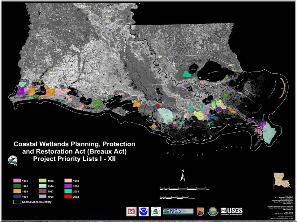
3 CWPPRA Monitoring Mandates an evaluation of the effectiveness of each coastal wetlands restoration project in achieving long-term solutions to arresting coastal wetlands lost in Louisiana a scientific evaluation of the effectiveness of the coastal wetlands restoration projects carried out under the plan in creating, restoring, protecting and enhancing coastal wetlands in Louisiana

4
5 Coastwide Reference Monitoring System Purpose: To improve our ability to determine the effectiveness of individual coastal restoration projects. Provide information to evaluate coastal wetlands at the ecosystem, basin, and restoration project scale. To determine the ecological condition of coastal wetlands based on the variables measured to ensure that the strategic coastal plan for Louisiana (Coast 2050 and LCA) is effective in recreating a sustainable coastal ecosystem.

6
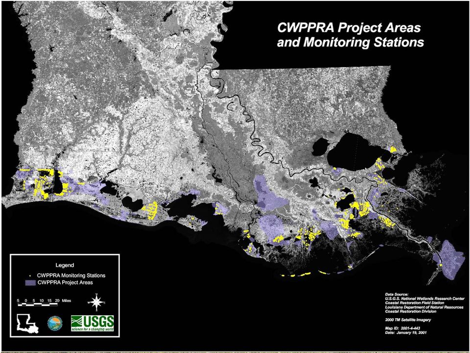
7 CRMS - Wetlands Design 612 CRMS-Wetlands sites to be established over the next 3 years. 200 sites will be collected annually with the remainder in a 3-year cycle. Year 1 sites in 2005/2006 and again in 2008/ stations in Barataria Basin will be sampled every year for first four years and re-sampled (Monte Carlo simulations) to assess power of design. Aspects of ecosystem structure and function will be measured at each site including elevation dynamics, vegetative assemblage, and hydrologic parameters to support functional model development.

8 Coastwide Reference Monitoring System - Wetlands September 26, 2005 Landrights Status: SECURED: 413 PENDING: 199 Secured Pending Total Annual Stations Year 1 Stations Year 2 Stations Year 3 Stations Total LANDRIGHTS

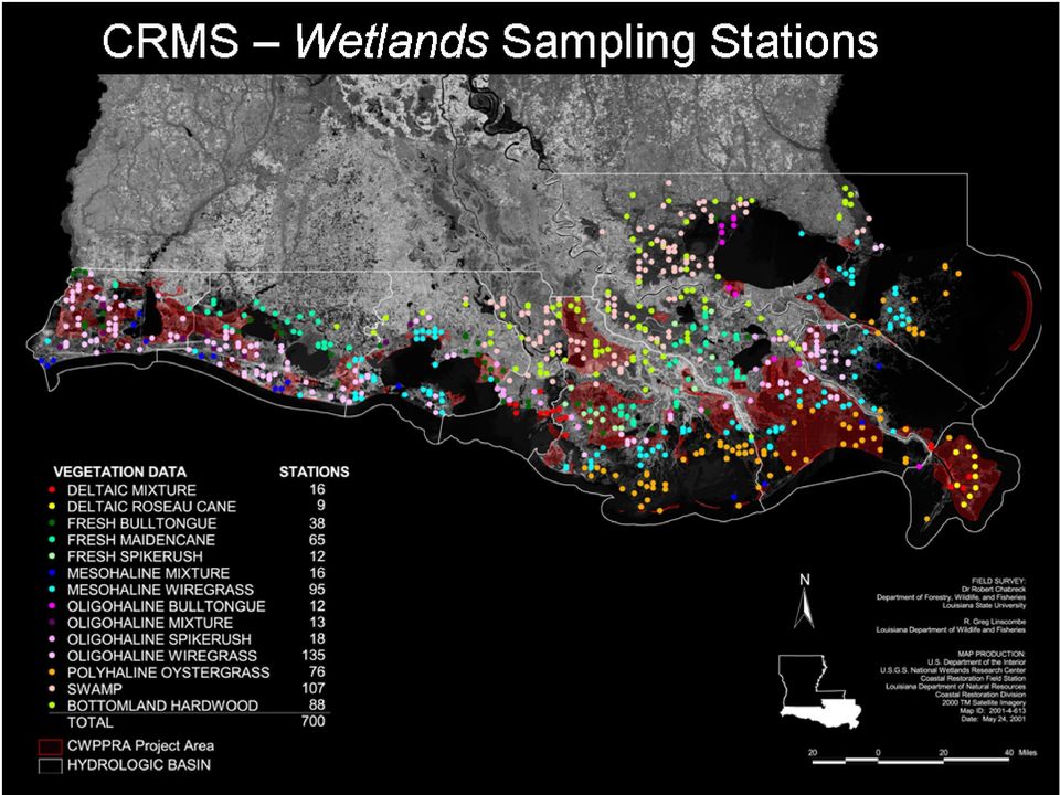
9 Data collection at each site Parameter Method Scale Frequency Land to Water Ratio Satellite Imagery Hydrologic Basin 3 years Land to Water Ratio Digital Aerial Photography CRMS Site (1 Km 2 ) 3 years Emergent Vegetation Braun Blanquet: % Cover, Species Richness, Height of Dominant Species (10) 2m x 2m plots/crms Site Annually during peak biomass Forested Vegetation DBH and Canopy Cover (5) 20m x 20m plots/crms Site Annually during peak biomass Vertical Accretion Feldspar Plots/Cryogenic Cores 3 plots/crms Site Bi-annually Marsh Elevation Change Rod Surface Elevation Table (RSET) 4 directions/crms Site Bi-annually Porewater Salinity 10 and 30 cm deep wells Syringe/Sipper 3 wells per depth/crms Site and at Vegetation Plots Monthly Annually Surface Water Salinity, Temp and Water Level Submersible Data Logger in available water within 200 m of CRMS Site or in a well Hourly Soil Characteristics Core samples profiled into 4 cm increments to 24 cm. Bulk Density, OM%, Soil Salinity, ph, and Moisture. 3 cores, 18 archived samples/crms Site Decade

10 TYPICAL CRMS SITE SAMPLING & DATA COLLECTION AREAS

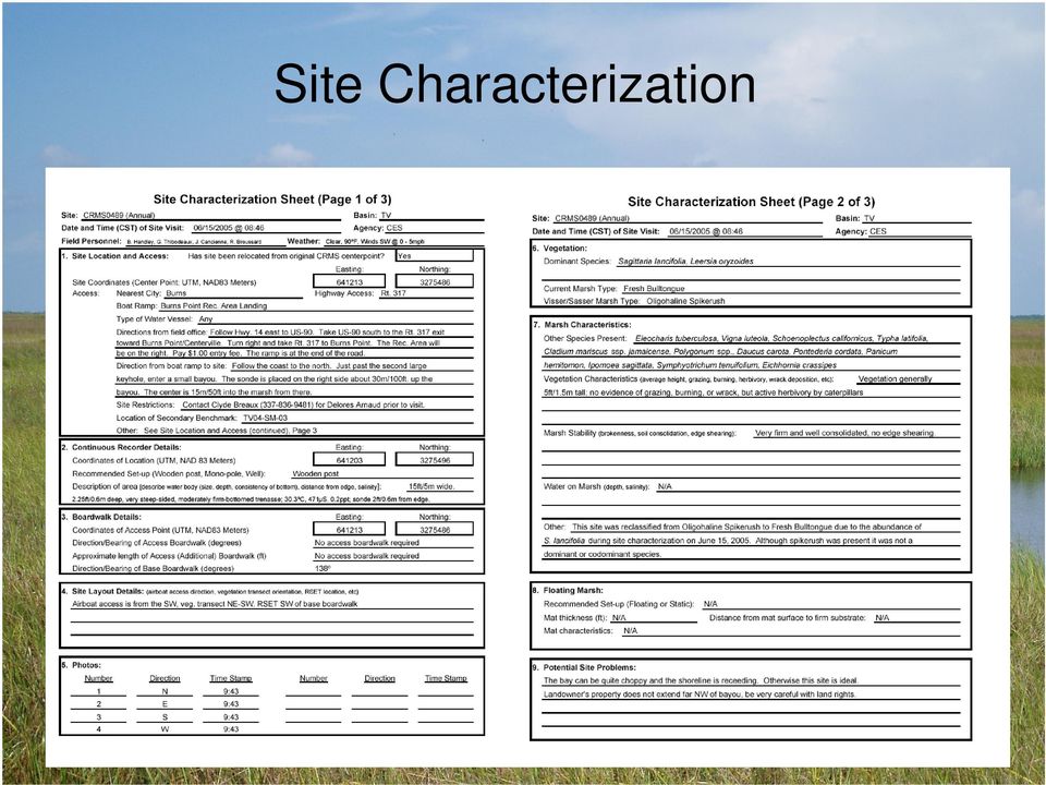
11 Site Characterization
12 Site schematic and photos

13 Site Features Porewater Wells SET Rod and Collar Recently Burnt

14 Project Status Milestones Landrights 413 of 612 sites secured Cost Share Agreement signed June 8, 2004 Standard Operating Procedures Manual finalized August 15, 2005 Contractor Selection secured February 1, 2005 Data Collection Equipment contract secured June 2005 Secondary Benchmarks installed 66 additional benchmarks in July and August 2005 Contractor Training phased training in March and August 2005 Site Construction began in July 2005

15 Project Status The CRMS construction and monitoring contract was awarded to Coastal Estuary Services, LLC (CES; a partnership between Shaw and CH2MHILL). Site establishment, construction, and initial data collection has begun on Year 1 and Annual CRMS-Wetlands Sites. 40 sites have been constructed and surveyed to NAVD88. Those sites are currently being assessed for damages from Hurricanes Katrina and Rita. Landrights are secured for 413 sites (68%). Landrights acquisition for the remaining 199 sites continues. Coastwide digital ortho-imagery acquisition will occur between October 15 and December 15, 2005 Website and Data Delivery Systems complete. Interactive graphing capabilities under development.

16 Public Data Retrieval CRMS-Wetlands monitoring data will be available through LDNR s data server, SONRIS Lite:

17 Linked spatial data and document retrieval

18

19 CRMS-Wetlands References Steyer, G. D., C. E. Sasser, J. M. Visser, E. M. Swenson, J. A. Nyman, and R. C. Raynie A proposed coast-wide reference monitoring system for evaluating wetland restoration trajectories in coastal Louisiana. Environmental Monitoring and Assessment 81: Visser, J. M., R. H. Chabreck, C. E. Sasser, R. G. Linscombe Marsh Vegetation Types of the Chenier Plain, Louisiana, USA. Estuaries 23(3): Visser, J. M., C. E. Sasser, R. H. Chabreck, and R. G. Linscombe Marsh vegetation types of the Mississippi River Deltaic Plain, USA. Estuaries 21(4B): Web links:
:318-327. Visser, J. M., C. E. Sasser, R. H. Chabreck, and R. G. Linscombe. 1998.")
CRMS Website Training
 CRMS Website Training March 2013 http://www.lacoast.gov/crms Coastwide Reference Monitoring System - Wetlands CWPPRA Restoration Projects Congressionally funded in 1990 Multiple restoration techniques
CRMS Website Training March 2015
 CRMS Website Training March 2015 http://www.lacoast.gov/crms CWPPRA Restoration Program CWPPRA was congressionally funded in 1990 and mandated 20 years of restoration project monitoring CWPPRA program
A STANDARD OPERATING PROCEDURES MANUAL FOR THE COAST-WIDE REFERENCE MONITORING SYSTEM-WETLANDS:
 A STANDARD OPERATING PROCEDURES MANUAL FOR THE COAST-WIDE REFERENCE MONITORING SYSTEM-WETLANDS: Methods for Site Establishment, Data Collection, and Quality Assurance/Quality Control Todd M. Folse, Jonathan
2005 Operations, Maintenance, and Monitoring Report
 State of Louisiana Department of Natural Resources Coastal Restoration Division and Coastal Engineering Division 2005 Operations, Maintenance, and Monitoring Report for WEST POINTE A LA HACHE SIPHON CONSTRUCTION
Chapter 2: Project Identification, Feasibility, and Planning
 Chapter 2: Project Identification, Feasibility, and Planning Project identification is the first step in the strategic planning process. Before spending significant time and resources on a project, restoration
UPPER COLUMBIA BASIN NETWORK VEGETATION CLASSIFICATION AND MAPPING PROGRAM
 UPPER COLUMBIA BASIN NETWORK VEGETATION CLASSIFICATION AND MAPPING PROGRAM The Upper Columbia Basin Network (UCBN) includes nine parks with significant natural resources in the states of Idaho, Montana,
Comprehensive Recommendations Supporting the Use of the Multiple Lines of Defense Strategy to Sustain Coastal Louisiana 2008 Report (Version I)
") Comprehensive Recommendations Supporting the Use of the Multiple Lines of Defense Strategy to Sustain Coastal Louisiana 2008 Report (Version I) This report recommends integrated coastal projects and levee
Comprehensive Recommendations Supporting the Use of the Multiple Lines of Defense Strategy to Sustain Coastal Louisiana 2008 Report (Version I) This report recommends integrated coastal projects and levee
Appendix B: Cost Estimates
 Appendix B: Estimates This appendix presents the estimated costs of the monitoring and supplemental research components presented in Section 3 of this document. A 20% quality assurance and quality control
Golden Triangle Marsh Creation. RESTORE Proposal Coastal Protection & Restoration Authority
 I. Summary Sheet Golden Triangle Marsh Creation Appendix A: Council Member Applicant and Proposal Information Summary Sheet Point of Contact: Jerome Zeringue Council Member: State of Louisiana Phone: (225)
Black Tern Distribution Modeling
 Black Tern Distribution Modeling Scientific Name: Chlidonias niger Distribution Status: Migratory Summer Breeder State Rank: S3B Global Rank: G4 Inductive Modeling Model Created By: Joy Ritter Model Creation
COASTAL MONITORING & OBSERVATIONS LESSON PLAN Do You Have Change?
 Coastal Change Analysis Lesson Plan COASTAL MONITORING & OBSERVATIONS LESSON PLAN Do You Have Change? NOS Topic Coastal Monitoring and Observations Theme Coastal Change Analysis Links to Overview Essays
Coastal Engineering Indices to Inform Regional Management
 Coastal Engineering Indices to Inform Regional Management Lauren Dunkin FSBPA 14 February 2013 Outline Program overview Standard products Coastal Engineering Index Conclusion and future work US Army Corps
Building Caribbean GeoNode Platform in Support of Climate Risk Management Jacob Opadeyi, PhD
 Building Caribbean GeoNode Platform in Support of Climate Risk Management Jacob Opadeyi, PhD Our Highly Vulnerable Region Housing developments on drainage channels and steep slopes Unapproved development
3. The submittal shall include a proposed scope of work to confirm the provided project description;
 QIN Shoreline Master Program Project Summary The Shoreline Master Program (SMP) development process for the Quinault Indian Nation (QIN) includes the completion of inventory and analysis report with corresponding
Water Monitoring System Website User Guide www.fldep-stevens.com
 Florida Department of Environmental Protection Division of State Lands Bureau of Survey and Mapping Water Monitoring System Website User Guide www.fldep-stevens.com Provided by Stevens Water Monitoring
AN INVESTIGATION OF THE GROWTH TYPES OF VEGETATION IN THE BÜKK MOUNTAINS BY THE COMPARISON OF DIGITAL SURFACE MODELS Z. ZBORAY AND E.
 ACTA CLIMATOLOGICA ET CHOROLOGICA Universitatis Szegediensis, Tom. 38-39, 2005, 163-169. AN INVESTIGATION OF THE GROWTH TYPES OF VEGETATION IN THE BÜKK MOUNTAINS BY THE COMPARISON OF DIGITAL SURFACE MODELS
REPORT TO REGIONAL WATER SUPPLY COMMISSION MEETING OF WEDNESDAY, SEPTEMBER 4, 2013 LEECH WATER SUPPLY AREA RESTORATION UPDATE
 Making a difference... together Agenda Item #9 REPORT #RWSC 2013-17 REPORT TO REGIONAL WATER SUPPLY COMMISSION MEETING OF WEDNESDAY, SEPTEMBER 4, 2013 SUBJECT LEECH WATER SUPPLY AREA RESTORATION UPDATE
The Use of Geographic Information Systems in Risk Assessment
 The Use of Geographic Information Systems in Risk Assessment With Specific Focus on the RiVAMP Methodology Presented by Nadine Brown August 27, 2012 Climate Studies Group Mona Climate Change Workshop Presentation
Greater New Orleans Hurricane and Storm Damage Risk Reduction System
 Greater New Orleans Hurricane and Storm Damage Risk Reduction System Mike Park Chief Task Force Hope Mississippi Valley Division U.S. Army Corps of Engineers March 15, 2011 US Army Corps of Engineers BUILDING
Estimating Potential Reduction Flood Benefits of Restored Wetlands
 Estimating Potential Reduction Flood Benefits of Restored Wetlands Kenneth W. Potter University of Wisconsin Introduction Throughout the summer of 1993 a recurring question was the impact of wetland drainage
Piping Plover Distribution Modeling
 Piping Plover Distribution Modeling Scientific Name: Charadrius melodus Distribution Status: Migratory Summer Breeder State Rank: S2B Global Rank: G3 Inductive Modeling Model Created By: Joy Ritter Model
Future of our coasts: Potential for natural and hybrid infrastructure to enhance ecosystem and community resilience Ariana Sutton-Grier
 Future of our coasts: Potential for natural and hybrid infrastructure to enhance ecosystem and community resilience Ariana Sutton-Grier University of Maryland & National Oceanic and Atmospheric Administration
Ariana Sutton-Grier, Holly Bamford & Kateryna Wowk University of Maryland and National Oceanic and Atmospheric Administration
 Future of our coasts: Potential for natural and hybrid infrastructure Ariana Sutton-Grier, Holly Bamford & Kateryna Wowk University of Maryland and National Oceanic and Atmospheric Administration Green
Survey and Mapping Activities in Vietnam *
 UNITED NATIONS E/CONF.100/CRP.1 ECONOMIC AND SOCIAL COUNCIL Eighteenth United Nations Regional Cartographic Conference for Asia and the Pacific Bangkok, 26-29 October 2009 Item 7(a) of the provisional
Sustainability Brief: Water Quality and Watershed Integrity
 Sustainability Brief: and Watershed Integrity New Jersey depends on water resources for the health of our people, the strength of our economy, and the vitality of our ecosystems. The quality of our water
Susan Iott U. S. General Accounting Office. Restoration of the South Florida Ecosystem
 Susan Iott U. S. General Accounting Office Restoration of the South Florida Ecosystem Presented at The Aspen Global Change Institute June 5-10, 2003 Summer Science Session I Learning from Regions: A Comparative
Image Analysis CHAPTER 16 16.1 ANALYSIS PROCEDURES
 CHAPTER 16 Image Analysis 16.1 ANALYSIS PROCEDURES Studies for various disciplines require different technical approaches, but there is a generalized pattern for geology, soils, range, wetlands, archeology,
IMPERVIOUS SURFACE MAPPING UTILIZING HIGH RESOLUTION IMAGERIES. Authors: B. Acharya, K. Pomper, B. Gyawali, K. Bhattarai, T.
 IMPERVIOUS SURFACE MAPPING UTILIZING HIGH RESOLUTION IMAGERIES Authors: B. Acharya, K. Pomper, B. Gyawali, K. Bhattarai, T. Tsegaye ABSTRACT Accurate mapping of artificial or natural impervious surfaces
San Francisco Bay Area Wetlands Restoration Program Design Review Group. Project Summary Outline
 San Francisco Bay Area Wetlands Restoration Program Design Review Group Project Summary Outline The project proponent desiring to have a project considered by the Design Review Group (DRG) shall provide
Communities, Biomes, and Ecosystems
 Communities, Biomes, and Ecosystems Before You Read Before you read the chapter, respond to these statements. 1. Write an A if you agree with the statement. 2. Write a D if you disagree with the statement.
Environmental Data Services for Delaware:
 Environmental Data Services for Delaware: Serving Emergency Responders, Planners, and Researchers Network Delaware Day November 6, 2013 Overview Operational Data Services More than just research DEOS and
Lower Raritan Watershed Management Area Stormwater & Flooding Subcommittee Strategy Worksheet LRSW-S3C1
 Strategy Name: Reduce Existing Potential for Flood Damages LRSW-S3C1. Develop and implement a program to: Minimize flood damages through the use of structural measures. Minimize flood damages through the
San Francisco Bay Margin Conservation Decision Support System (DSS)
") San Francisco Bay Margin Conservation Decision Support System (DSS) Presented by Brian Fulfrost1, MS David Thomson2, MS 1 Brian Fulfrost and Associates 2 San Francisco Bay Bird Observatory Transitional
San Francisco Bay Margin Conservation Decision Support System (DSS) Presented by Brian Fulfrost1, MS David Thomson2, MS 1 Brian Fulfrost and Associates 2 San Francisco Bay Bird Observatory Transitional
Mobilising Vegetation Plot Data: the National Vegetation Survey Databank. Susan Wiser April 2016 http://nvs.landcareresearch.co.nz
 Mobilising Vegetation Plot Data: the National Vegetation Survey Databank Susan Wiser April 2016 http://nvs.landcareresearch.co.nz Nationally Significant Databases and Collections http://natsigdc.landcareresearch.co.nz/natsigdc_list.html
FINAL Environmental Impact Statement (EIS) for the
 for the") FINAL Environmental Impact Statement (EIS) for the Mississippi River-Gulf Outlet (MRGO), Louisiana, and Lake Borgne Wetland Creation and Shoreline Protection Project U.S. Army Corps of Engineers New Orleans
FINAL Environmental Impact Statement (EIS) for the Mississippi River-Gulf Outlet (MRGO), Louisiana, and Lake Borgne Wetland Creation and Shoreline Protection Project U.S. Army Corps of Engineers New Orleans
How to do it Manual No. 3: ArcMap10 in Remote Desktop mode and Landgate slip files. Jeremy Green
 How to do it Manual No. 3: ArcMap10 in Remote Desktop mode and Landgate slip files Jeremy Green Report Department of Maritime Archaeology No. 268 2010 Getting started with ArcInfo10 The ArcInfo10 exists
World Data Center for Biodiversity and Ecology - ICSU WDC System. OAS/IABIN Protected Area Meeting January 23, 2007
 World Data Center for Biodiversity and Ecology - ICSU WDC System OAS/IABIN Protected Area Meeting January 23, 2007 WDCBE Partnerships ICSU World Data Center System USGS Host(s) - National Biological Information
Fire, Forest History, and Ecological Restoration of Ponderosa Pine Forests at Mount Rushmore, South Dakota
 Fire, Forest History, and Ecological Restoration of Ponderosa Pine Forests at Mount Rushmore, South Dakota Restoration uses the past not as a goal but as a reference point for the future...it is not to
Hydrographic Survey of the Keith Lake-Salt Bayou System
 Hydrographic Survey of the Keith Lake-Salt Bayou System April 2007 Survey Prepared by: The Texas Water Development Board December 2007 Texas Water Development Board J. Kevin Ward, Executive Administrator
Burrowing Owl Distribution Modeling
 Burrowing Owl Distribution Modeling Scientific Name: Athene cunicularia Distribution Status: Migratory Summer Breeder State Rank: S3B Global Rank: G4 Inductive Modeling Model Created By: Joy Ritter Model
Deepwater Horizon Oil Spill Phase I Early Restoration Plan and Environmental Assessment
 Deepwater Horizon Oil Spill Phase I Early Restoration Plan and Environmental Assessment Prepared by the Deepwater Horizon Natural Resource Trustees from State of Alabama State of Florida State of Louisiana
GERSVIEW: A New Database for Web Mapping
 GERSVIEW: A New Database for Web Mapping William J. Hernández, M.S. Graduate Student Department of Marine Sciences-UPRM Fernando Gilbes, Ph.D. Associate Professor Department of Geology-UPRM Overview Objectives
ERP: Willamette-Ecosystem Services Project
 ERP: Willamette-Ecosystem Services Project Presented by Iris Goodman to NAS Sustainability R&D Forum October 17-18, 2007 Conserving ecosystem services through proactive decision-making making Linking Human
Cost Considerations of Using LiDAR for Timber Inventory 1
 Cost Considerations of Using LiDAR for Timber Inventory 1 Bart K. Tilley, Ian A. Munn 3, David L. Evans 4, Robert C. Parker 5, and Scott D. Roberts 6 Acknowledgements: Mississippi State University College
Long-term Marine Monitoring in Willapa Bay. WA State Department of Ecology Marine Monitoring Program
 Long-term Marine Monitoring in Willapa Bay WA State Department of Ecology Marine Monitoring Program Ecology s Marine Waters Monitoring Program Goal: establish and maintain baseline environmental data Characterize
CIESIN Columbia University
 Conference on Climate Change and Official Statistics Oslo, Norway, 14-16 April 2008 The Role of Spatial Data Infrastructure in Integrating Climate Change Information with a Focus on Monitoring Observed
Appendix J Online Questionnaire
 Appendix J Online Questionnaire In accordance with the Paperwork Reduction Act, this questionnaire was approved by the Office of Management and Budget (OMB). The OMB control number and expiration date
Aquatic Biomes, Continued
 Aquatic Biomes, Continued Introduction Extent of Marine biomes Issues & challenges Factors influencing distribution Dynamics in time & space Depth Tour of marine biomes Issues (by biome) Freshwater biomes
How do abiotic factors and physical processes impact life in the ocean?
 This website would like to remind you: Your browser (Apple Safari 7) is out of date. Update your browser for more security, comfort and the best experience on this site. Activitydevelop Ocean Abiotic Factors
Understanding Raster Data
 Introduction The following document is intended to provide a basic understanding of raster data. Raster data layers (commonly referred to as grids) are the essential data layers used in all tools developed
WHAT IS GIS - AN INRODUCTION
 WHAT IS GIS - AN INRODUCTION GIS DEFINITION GIS is an acronym for: Geographic Information Systems Geographic This term is used because GIS tend to deal primarily with geographic or spatial features. Information
Soil Moisture Estimation Using Active DTS at MOISST Site
 MOISST Workhsop, 2014 Soil Moisture Estimation Using Active DTS at MOISST Site June 4, 2014 Chadi Sayde, Daniel Moreno, John Selker Department of Biological and Ecological Engineering Oregon State University,
National and Sub-national Carbon monitoring tools developed at the WHRC
 National and Sub-national Carbon monitoring tools developed at the WHRC Nadine Laporte Woods Hole Research Center A. Baccini, W. Walker, S. Goetz, M. Sun, J. Kellndorfer Kigali, 20 th June 2011 Why measuring
Policy & Management Applications of Blue Carbon. fact SHEET
 Policy & Management Applications of Blue Carbon fact SHEET Policy & Management Applications of Blue Carbon Coastal Blue Carbon - An Important Wetland Ecosystem Service Coastal Blue Carbon refers to the
NATURAL RESOURCE RESTORATION LESSON PLAN Fix It!
 NATURAL RESOURCE RESTORATION LESSON PLAN Fix It! Theme Repairing Damaged Resources Links to Overview Essays and Resources Needed for Student Research http://oceanservice.noaa.gov/education/corals http://oceanservice.noaa.gov/topics/coasts/restoration/
Coastal Restoration Spending in Louisiana Economic Impact Analysis
 Coastal Restoration Spending in Louisiana Economic Impact Analysis Louisiana Workforce Commission www.lmi.laworks.net/green September 2011 In 2009, Louisiana and Mississippi partnered to research economic
Restoration Planning and Development of a Restoration Bank
 Restoration Planning and Development of a Restoration Bank Black Creek Pioneer Village, South Theatre 8:30 a.m. to 3:30 p.m. Habitat Restoration and Environmental Monitoring Projects Section Restoration
Urban Ecosystem Analysis Atlanta Metro Area Calculating the Value of Nature
 August 2001 Urban Ecosystem Analysis Atlanta Metro Area Calculating the Value of Nature Report Contents 2 Project Overview and Major Findings 3 Regional Analysis 4 Local Analysis 6 Using Regional Data
The following was presented at DMT 14 (June 1-4, 2014, Newark, DE).
.") DMT 2014 The following was presented at DMT 14 (June 1-4, 2014, Newark, DE). The contents are provisional and will be superseded by a paper in the DMT 14 Proceedings. See also presentations and Proceedings
DMT 2014 The following was presented at DMT 14 (June 1-4, 2014, Newark, DE). The contents are provisional and will be superseded by a paper in the DMT 14 Proceedings. See also presentations and Proceedings
APPENDIX A : 1998 Survey of Proprietary Risk Assessment Systems
 APPENDIX A : 1998 Survey of Proprietary Risk Assessment Systems In its 1997 paper, the working party reported upon a survey of proprietary risk assessment systems designed for use by UK household insurers
Mariana Leckner, Ph.D., Professor, American Military University Thomas O. Herrington, Ph.D. Associate Professor, Stevens Institute of Technology
 Mariana Leckner, Ph.D., Professor, American Military University Thomas O. Herrington, Ph.D. Associate Professor, Stevens Institute of Technology National Hydrologic Warning Council Training Conference
INVESTIGA I+D+i 2013/2014
 INVESTIGA I+D+i 2013/2014 SPECIFIC GUIDELINES ON AEROSPACE OBSERVATION OF EARTH Text by D. Eduardo de Miguel October, 2013 Introducction Earth observation is the use of remote sensing techniques to better
Assessing Hurricane Katrina Damage to the Mississippi Gulf Coast Using IKONOS Imagery
 Assessing Hurricane Katrina Damage to the Mississippi Gulf Coast Using IKONOS Imagery Joseph P. Spruce Science Systems and Applications, Inc. John C., MS 39529 Rodney McKellip NASA Project Integration
Most informed people realize that cumulative impacts have had
 Welcome to the First Issue of Rivers & Coast! The goal of the new Rivers & Coast newsletter is to keep readers well informed of current scientific understanding behind key environmental issues related
Field Techniques Manual: GIS, GPS and Remote Sensing
 Field Techniques Manual: GIS, GPS and Remote Sensing Section A: Introduction Chapter 1: GIS, GPS, Remote Sensing and Fieldwork 1 GIS, GPS, Remote Sensing and Fieldwork The widespread use of computers
Lidar Remote Sensing for Forestry Applications
 Lidar Remote Sensing for Forestry Applications Ralph O. Dubayah* and Jason B. Drake** Department of Geography, University of Maryland, College Park, MD 0 *[email protected] **[email protected] 1
RESTORATION AND ENHANCEMENT OF SOUTHERN CALIFORNIA LAGOONS
 RESTORATION AND ENHANCEMENT OF SOUTHERN CALIFORNIA LAGOONS by Hany Elwany, Ph.D. Scripps Institution of Oceanography Headwaters to Oceans Conference 25 October 2003 CE Ref #03-22 San Diego County Lagoons
Applying MIKE SHE to define the influence of rewetting on floods in Flanders
 Applying MIKE SHE to define the influence of rewetting on floods in Flanders MARK HENRY RUBARENZYA 1, PATRICK WILLEMS 2, JEAN BERLAMONT 3, & JAN FEYEN 4 1,2,3 Hydraulics Laboratory, Department of Civil
The National Park Service Inventory & Monitoring Program Student Opportunities
 NPS Inventory and Monitoring Program The National Park Service Inventory & Monitoring Program Student Opportunities Sara Stevens Program Manager NPS Inventory and Monitoring Program NPS Programs at URI
Michigan Wetlands. Department of Environmental Quality
 Department of Environmental Quality Wetlands are a significant component of Michigan s landscape, covering roughly 5.5 million acres, or 15 percent of the land area of the state. This represents about
Basic Climatological Station Metadata Current status. Metadata compiled: 30 JAN 2008. Synoptic Network, Reference Climate Stations
 Station: CAPE OTWAY LIGHTHOUSE Bureau of Meteorology station number: Bureau of Meteorology district name: West Coast State: VIC World Meteorological Organization number: Identification: YCTY Basic Climatological
INTEGRATED NATIONAL ADAPTATION PILOT República de Colombia INAP
 INTEGRATED NATIONAL ADAPTATION PILOT INAP Ecosystem Based Adaptation High Mountain Ecosystems Angela Andrade Technical Coordinator INAP Klaus Schutze Páez Coordinator Comp B CLIMATE CHANGE IN COLOMBIA
Image source: www.rivers.gov. Visual Data Analytics, LLC
 AWRA Spring Specialty AWRA Conference Spring Specialty on GIS Conference and Water on Resources GIS and Water VIII Resources May 13, 2014 Using a Temporal Information System for Visualization and Analysis
Asia-Pacific Environmental Innovation Strategy (APEIS)
") Asia-Pacific Environmental Innovation Strategy (APEIS) Integrated Environmental Monitoring IEM) Dust Storm Over-cultivation Desertification Urbanization Floods Deforestation Masataka WATANABE, National
Asia-Pacific Environmental Innovation Strategy (APEIS) Integrated Environmental Monitoring IEM) Dust Storm Over-cultivation Desertification Urbanization Floods Deforestation Masataka WATANABE, National
MAPPING MINNEAPOLIS URBAN TREE CANOPY. Why is Tree Canopy Important? Project Background. Mapping Minneapolis Urban Tree Canopy.
 MAPPING MINNEAPOLIS URBAN TREE CANOPY Why is Tree Canopy Important? Trees are an important component of urban environments. In addition to their aesthetic value, trees have significant economic and environmental
Urban Waters and River Restoration. Pinja Kasvio, Finnish Environment Institute, SYKE RESTORE North Region Closing Seminar 14.8.
 Urban Waters and River Restoration Pinja Kasvio, Finnish Environment Institute, SYKE RESTORE North Region Closing Seminar 14.8.2013 Urban Waters Hålland, Gässlösa (Sweden) Characteristics of urban areas:
Michigan Tech Research Institute Wetland Mitigation Site Suitability Tool
 Michigan Tech Research Institute Wetland Mitigation Site Suitability Tool Michigan Tech Research Institute s (MTRI) Wetland Mitigation Site Suitability Tool (WMSST) integrates data layers for eight biophysical