Search and Rescue - GIS
|
|
|
- Coral Potter
- 7 years ago
- Views:
Transcription

1 Search and Rescue - GIS By: Don Ferguson By: Cole Brown, Search Manager

2 History of SAR Maps Most SAR Maps were Topographical Maps for USGS 7.5 Minute Quadrangle. From 1987 to 2003 Quads with no gridlines. Searchers with no GPS s No way to reproduce Maps Most searches occur across two maps. Some used a clear acetate Grid with no geo-reference. An ASTM Standard for Developing a Search Map was written and approved in 1997 using UTM for Geo-Reference. Search managers use to carry 450 quads for Maryland.

3 History of SAR Maps
4 History of SAR Maps
5 From 2002 to 2011 A little company called Maptech, Inc. developed a GIS-lite application that had seamless topo s for all of Maryland. Terrain Navigator Pro In 2002 TNP added Aerial Photo s at 1:12,000. But were black and white and later versions was color with leaf on.


6 Terrain Navigator Pro

7 Today All search managers have a Toughbook laptop with Terrain Navigator Pro and the Ortho s and topo s loaded They also have Cutewriter so they can make PDF maps for sending to the Barrack for Printing. They also have GPS s Fortrex 401 We can download tracks from Searchers
8 Typical Search Needs Search map to mark the location for searchers to go and provide to searchers. Map to analyze the topography against the circumstances why they are missing and apply statistical information from Lost Person Behavior data. Plot the various clues and points of the map to determine if there is a pattern.
9 GIS in SAR is Expanding Using ERSI ArcGIS and tools made for SAR we are able to make better maps and provide more analytics. Field Mobility Data Management Planning and Analysis Situational Awareness Collaboration Documentation
10 MAPSAR and IGT4SAR GIS Tool built on the ArcGIS platform created by a consortium of volunteer/professional SAR Personnel and software developers. Effort was lead by Sierra Madre SAR Team, National Park Service and ESRI. It allows for data collection, map generating, segmenting, tracking assets and assignments, and clue logging. It also does behavioral and spatial analysis, automated form generation, probability theory and performance metrics.
11 Minimal Essential Datasets (MEDS) For IGT4SAR to operate we need a good base map and a good internet connection. Base Map USGS Topographical Map 1:24K Ortho Color with Leaf off 1:12K or Better Data Elevation Model (DEM) 6 or 3 meter. National Land Cover Data 30 meter
12 Minimal Essential Datasets (MEDS) Feature Classes Road Centerlines Hydrology Steams and Water Bodies Driveway Land Parcels Address Points City, County, State Boundary Cell Towers Trails Fence Lines
13 DEM and NLCD Cell Phone and Radio Propagation Communications Planning Mobility and Travel predictions Evaluate paths of least resistance Terrain analysis for collecting features Defining Search Segments boundaries
14 Currently We have access to 6 imagery via MD IMAP online. Need a disconnect statewide solution. We have access to USGS Topo via ArcMap online. Need a disconnect statewide solution. We have 75% access to DEM via Eastern Shore Regional GIS Cooperative. Need a disconnect statewide solution. We have NLCD and Maryland Land Use Data

15 Standard Geo-Referencing in SAR United States National Grid NAD 83 UTM Zone 18N or 17N 18S TJ
16 Standard Geo-Referencing in SAR Latitude and Longitude in Degree Decimal Minute format Degrees, Decimal Minutes (to the Hundredth) by = Degrees = Minutes = Seconds. = Decimal
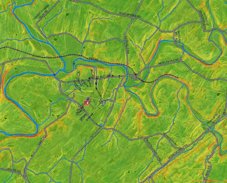
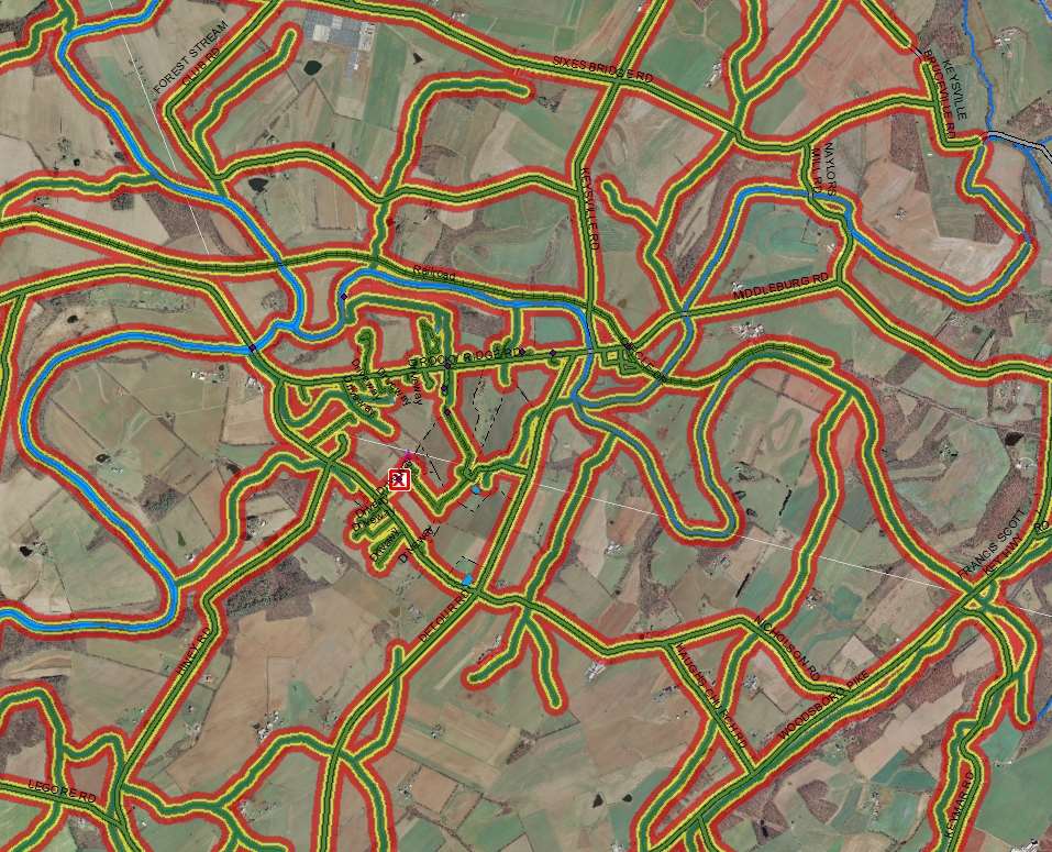
17
18 NSARC Geo-referencing Matrix for Catastrophic Incident SAR Georeference System User USNG Latitude/Longitude DD-MM.mmm(1) GARS Land SAR Responder(2) Primary Secondary N/A Aeronautical SAR Responders (3) Secondary Primary Tertiary Air Space Deconfliction (4) N/A Primary N/A Land SAR Responder/ Aeronautical SAR Responder Interface (5) Primary Secondary N/A Incident Command: Air SAR Coordination Land SAR Coordination Area organization and accountability (6) Secondary Primary N/A Primary Secondary N/A Secondary Tertiary Primary
19 International SAR GIS Standard

20 International SAR GIS Standard
21 This Map has: Latitude / Longitude in the right format US National Grid Magnetic Declination It has the right Datum NAD83 or WGS 84
22
23
24 Case Study Mr. Frank Sottile, 90 yr. old Male Was at a family Picnic at Family Farm in Keymar, MD. Went Missing 9/1/2012 at 16:00 He was with his daughter and family. He walked out the driveway of the farm to review the farms condition. He was disappointed. In 10 min he was gone. They currently live in Montgomery County. Search started at 17:00 and ended at 09:00 over 16 hrs He was found alive and in good health approx. 1.5 miles away.
25

26 DEM with Hillshade
27 Slope

28 Track Offset
29

30 Mobility Model
31
32
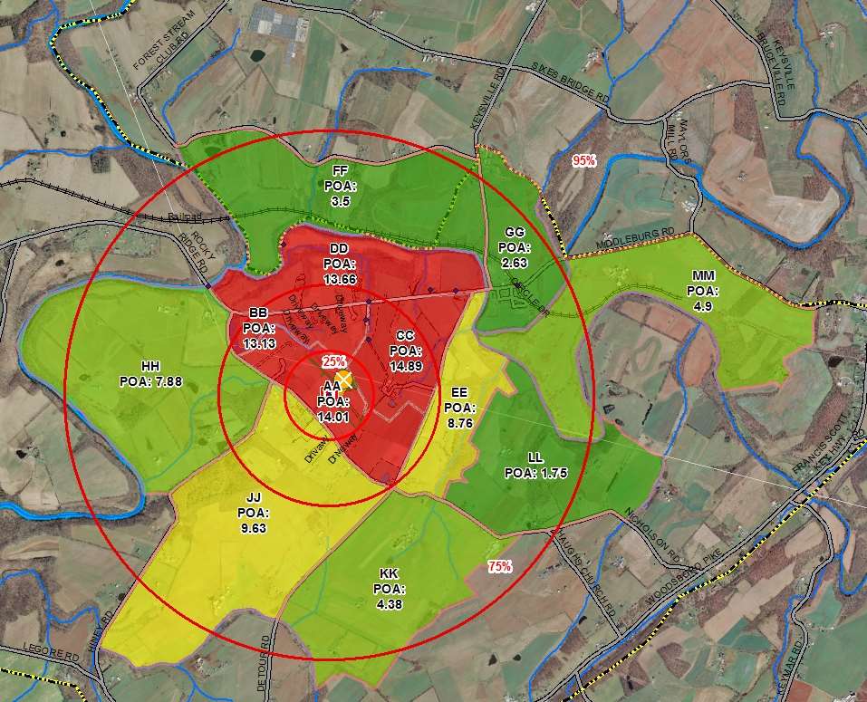
33 Search Probability Map

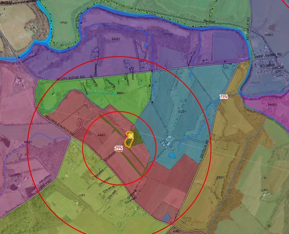
34 Segments

35 With Tracks

36 Thank you Cole Brown
National Register of Historic Places: GIS Webinar Cultural Resource GIS Facility National Park Service June 2012
 National Register of Historic Places: GIS Webinar Cultural Resource GIS Facility National Park Service June 2012 In February and March 2012 the National Register of Historic Places held webinars in conjunction
Create a folder on your network drive called DEM. This is where data for the first part of this lesson will be stored.
 In this lesson you will create a Digital Elevation Model (DEM). A DEM is a gridded array of elevations. In its raw form it is an ASCII, or text, file. First, you will interpolate elevations on a topographic
Learning about GPS and GIS
 Learning about GPS and GIS Standards 4.4 Understand geographic information systems (G.I.S.). B12.1 Understand common surveying techniques used in agriculture (e.g., leveling, land measurement, building
Utah State General Records Retention Schedule SCHEDULE 1 GEOSPATIAL DATA SETS
 Utah State General Records Retention Schedule SCHEDULE 1 BIOTA RECORDS (Item 1-26) These are geospatial records that depict wildlife use areas in the state of Utah as determined by wildlife biologists
v Software Release Notice -. Acquired Software
 v Software Release Notice -. Acquired Software 1. Software Name: Software Version: ArcView GIs@ 3.3 2. Software Function: ArcView GIS 3.3, developed by Environmental Systems Research Institute, Inc. (ESRI@),
Finding GIS Data and Preparing it for Use
 Finding_Data_Tutorial.Doc Page 1 of 19 Getting Ready for the Tutorial Sign Up for the GIS-L Listserv Finding GIS Data and Preparing it for Use The Yale University GIS-L Listserv is an internal University
GIS: Geographic Information Systems A short introduction
 GIS: Geographic Information Systems A short introduction Outline The Center for Digital Scholarship What is GIS? Data types GIS software and analysis Campus GIS resources Center for Digital Scholarship
Introduction to GIS. http://libguides.mit.edu/gis
 Introduction to GIS http://libguides.mit.edu/gis 1 Overview What is GIS? Types of Data and Projections What can I do with GIS? Data Sources and Formats Software Data Management Tips 2 What is GIS? 3 Characteristics
A Method Using ArcMap to Create a Hydrologically conditioned Digital Elevation Model
 A Method Using ArcMap to Create a Hydrologically conditioned Digital Elevation Model High resolution topography derived from LiDAR data is becoming more readily available. This new data source of topography
MD imap 2.0 THE NEXT GENERATION OF MARYLAND S ENTERPRISE GIS. Esri MUG Conference Baltimore, MD December 3, 2014 http://imap.maryland.
 THE NEXT GENERATION OF MARYLAND S ENTERPRISE GIS MD imap 2.0 Matt Sokol, GISP Senior GIS Analyst Maryland Department of Information Technology Geographic Information Office Julia Fischer, GISP Senior GIS
REGIONAL SEDIMENT MANAGEMENT: A GIS APPROACH TO SPATIAL DATA ANALYSIS. Lynn Copeland Hardegree, Jennifer M. Wozencraft 1, Rose Dopsovic 2 INTRODUCTION
 REGIONAL SEDIMENT MANAGEMENT: A GIS APPROACH TO SPATIAL DATA ANALYSIS Lynn Copeland Hardegree, Jennifer M. Wozencraft 1, Rose Dopsovic 2 ABSTRACT: Regional sediment management (RSM) requires the capability
Exer. 1 Using Handheld GPS for location & recording points
 Exer. 1 Using Handheld GPS for location & recording points Field Objectives: 1. Familiarity with handheld receivers (Trimble Juno) 2. Basic positioning in Lat/Long and UTM 3. Familiarity with changing
GEOGRAPHIC INFORMATION SYSTEMS Lecture 20: Adding and Creating Data
 Adding Existing Data Into ArcGIS - there are many different ways to get data into ArcGIS GEOGRAPHIC INFORMATION SYSTEMS Lecture 20: Adding and Creating Data Add Data - normally we use the Add Data button
Public Hearing in the Matter of the Issues on Emergency Medical Services Helicopter Operational Safety;
 Regarding the: Public Hearing in the Matter of the Issues on Emergency Medical Services Helicopter Operational Safety; and In support of the National Search and Rescue Committee s (NSARC) standardization
GIS-Based Road Inventory Application for the USDOT FHWA. Bobby Harris Senior Manager bd Systems, Spatial Division
 GIS-Based Road Inventory Application for the USDOT FHWA Bobby Harris Senior Manager bd Systems, Spatial Division Overview of Presentation Background Objectives of Pilot Project Challenges Review of Web-Based
ANALYSIS 3 - RASTER What kinds of analysis can we do with GIS?
 ANALYSIS 3 - RASTER What kinds of analysis can we do with GIS? 1. Measurements 2. Layer statistics 3. Queries 4. Buffering (vector); Proximity (raster) 5. Filtering (raster) 6. Map overlay (layer on layer
GIS III: GIS Analysis Module 2a: Introduction to Network Analyst
 *** Files needed for exercise: nc_cty.shp; target_stores_infousa.dbf; streets.sdc (provided by street map usa); NC_tracts_2000sf1.shp Goals: To learn how to use the Network analyst tools to perform network
Introduction to GIS (Basics, Data, Analysis) & Case Studies. 13 th May 2004. Content. What is GIS?
 & Case Studies. 13 th May 2004. Content. What is GIS?") Introduction to GIS (Basics, Data, Analysis) & Case Studies 13 th May 2004 Content Introduction to GIS Data concepts Data input Analysis Applications selected examples What is GIS? Geographic Information
Introduction to GIS (Basics, Data, Analysis) & Case Studies 13 th May 2004 Content Introduction to GIS Data concepts Data input Analysis Applications selected examples What is GIS? Geographic Information
Earth Data Science in The Era of Big Data and Compute
 Earth Data Science in The Era of Big Data and Compute E. Lynn Usery U.S. Geological Survey usery@usgs.gov http://cegis.usgs.gov U.S. Department of the Interior U.S. Geological Survey Board on Earth Sciences
delorme.com/earthmate Earthmate A Guide to the Complete GPS Navigation Solution for Smartphones and Tablets.
 delorme.com/earthmate Earthmate A Guide to the Complete GPS Navigation Solution for Smartphones and Tablets. EARTHMATE I N C L U D E D A guide to Earthmate Hunt Edition is included in this document. Earthmate
Using Google Earth for Environmental Science Research
 Using Google Earth for Environmental Science Research This document is up-to-date as of August 2013. If you have any questions or additions to this material please email dan.friess@nus.edu.sg. Note: this
Development of an Impervious-Surface Database for the Little Blackwater River Watershed, Dorchester County, Maryland
 Development of an Impervious-Surface Database for the Little Blackwater River Watershed, Dorchester County, Maryland By Lesley E. Milheim, John W. Jones, and Roger A. Barlow Open-File Report 2007 1308
GPS Applications in Agriculture. Gary T. Roberson Agricultural Machinery Systems
 GPS Applications in Agriculture Gary T. Roberson Agricultural Machinery Systems What is a Positioning System? A position information system enables the user to determine absolute or relative location of
GIS EXAM #2 QUERIES. Attribute queries only looks at the records in the attribute tables to some kind of
 GIS EXAM #2 QUERIES - Queries extracts particular records from a table or feature class for use; - Queries are an essential aspect of GIS analysis, and allows us to interrogate a dataset and look for patterns;
How to georectify an image in ArcMap 10
 How to georectify an image in ArcMap 10 The University Library has a large collection of historical aerial photos for some North Carolina Counties ( http://www.lib.unc.edu/reference/gis/usda/index.html
The Development and Implementation of a GIS System for Sunde Land Surveying, LLC.
 The Development and Implementation of a GIS System for Sunde Land Surveying, LLC. Ryan R. Bormann 1,2 1 Department of Resource Analysis, Saint Mary s University of Minnesota, Winona, MN 55987. 2 Sunde
Gunnison County Web Map
 Gunnison County Web Map Find Data - Find data - Navigate tools - Mouse over tooltip Make Maps - Layers - Legend - Drawing tools - Printing Analysis - Measurement - Selecting - Queries Spatial SQL - Basic
WHAT IS GIS - AN INRODUCTION
 WHAT IS GIS - AN INRODUCTION GIS DEFINITION GIS is an acronym for: Geographic Information Systems Geographic This term is used because GIS tend to deal primarily with geographic or spatial features. Information
What do I do first in ArcView 8.x? When the program starts Select from the Dialog box: A new empty map
 www.library.carleton.ca/find/gis Introduction Introduction to Georeferenced Images using ArcGIS Georeferenced images such as aerial photographs or satellite images can be used in many ways in both GIS
GEOGRAPHIC INFORMATION SYSTEMS
 GIS GEOGRAPHIC INFORMATION SYSTEMS FOR CADASTRAL MAPPING Chapter 6 2015 Cadastral Mapping Manual 6-0 GIS - GEOGRAPHIC INFORMATION SYSTEMS What is GIS For a long time people have sketched, drawn and studied
Request for Proposals for Topographic Mapping. Issued by: Teton County GIS and Teton County Engineering Teton County, Wyoming
 Request for Proposals for Topographic Mapping Issued by: Teton County GIS and Teton County Engineering Teton County, Wyoming Proposals due: 2:00PM MDT July 1, 2015 Proposals may be delivered to: Teton
Introduction to Imagery and Raster Data in ArcGIS
 Esri International User Conference San Diego, California Technical Workshops July 25, 2012 Introduction to Imagery and Raster Data in ArcGIS Simon Woo slides Cody Benkelman - demos Overview of Presentation
Geotechnical Data Sharing and Electronic Data Exchange at Minnesota DOT. Derrick D. Dasenbrock 1, M. ASCE, P.E.
 Geotechnical Data Sharing and Electronic Data Exchange at Minnesota DOT Derrick D. Dasenbrock 1, M. ASCE, P.E. 1 Minnesota Department of Transportation, 1400 Gervais Ave, Maplewood, MN, 55109 USA PH (651)
Creating the US Topo
 Creating the US Topo A Process Discussion National Geospatial Program Office National Geospatial Technical Operations Center Helmut Lestinsky Graphics Product Specialist MOD Project Manager U.S. Department
How To Hydrologically Condition A Digital Dam
 Program: Funding: Conservation Applications of LiDAR Data http://tsp.umn.edu/lidar Environment and Natural Resources Trust Fund Module: Instructor: Hydrologic Applications Sean Vaughn, DNR GIS Hydrologist
GIS III: GIS Analysis Module 1a: Network Analysis Tools
 *** Files needed for exercise: MI_ACS09_cty.shp; USBusiness09_MI.dbf; MI_ACS09_trt.shp; and streets.sdc (provided by Street Map USA) Goals: To learn how to use the Network Analyst tools to perform network-based
Metadata for Big River Watershed Geologic and Geomorphic Data
 Metadata for Big River Watershed Geologic and Geomorphic Data Metadata are descriptions and information regarding compiled data. This appendix contains the metadata that describes the compiled data used
Maps A Primer for Content & Production of Topographic Base Maps For Design Presented by SurvBase, LLC
 Maps A Primer for Content & Production of Topographic Base Maps For Design Presented by Definition and Purpose of, Map: a representation of the whole or a part of an area. Maps serve a wide range of purposes.
Guide to Viewing Maps in Google Earth
 Guide to Viewing Maps in Google Earth The BCT made the decision to provide the GIS (Geographic Information System) resources for Bat Groups in the form of Google Earth maps because they do not require
LAR-IAC4 Status and User Group Meeting. October 8, 2015
 LAR-IAC4 Status and User Group Meeting October 8, 2015 Agenda LARIAC Imagery Update LARIAC Status Update LARIAC Update and Training Schedule LARIAC Data Access Methods Additional Derived Data User Presentations
MINIMUM STANDARDS FOR ACCEPTANCE OF AQUATIC RESOURCES DELINEATION REPORTS
 MINIMUM STANDARDS FOR ACCEPTANCE OF AQUATIC RESOURCES DELINEATION REPORTS U.S. ARMY CORPS OF ENGINEERS BUILDING STRONG January 2016 The U.S Army Corps of Engineers, through its Regulatory Program, regulates
Understanding Raster Data
 Introduction The following document is intended to provide a basic understanding of raster data. Raster data layers (commonly referred to as grids) are the essential data layers used in all tools developed
Introduction to ArcMap for Water Resources Data
 Introduction to ArcMap for Water Resources Data Barbara Parmenter and Jack Melcher, revised: 9/15/2011 INTRODUCTION... 1 CHOOSING A HCDN STATION FOR WATERSHED MAPPING... 2 DOWNLOADING DATA FROM THE NATIONAL
Managing Imagery and Raster Data in ArcGIS
 Technical Workshops Managing Imagery and Raster Data in ArcGIS Hong Xu, Sangeet Mathew, Mark Harris Presentation Overview ArcGIS raster data models Which model to use Mosaic dataset storage and properties
GIS. Digital Humanities Boot Camp Series
 GIS Digital Humanities Boot Camp Series GIS Fundamentals GIS Fundamentals Definition of GIS A geographic information system (GIS) is used to describe and characterize spatial data for the purpose of visualizing
A GIS helps you answer questions and solve problems by looking at your data in a way that is quickly understood and easily shared.
 A Geographic Information System (GIS) integrates hardware, software, and data for capturing, managing, analyzing, and displaying all forms of geographically referenced information. GIS allows us to view,
Tutorial 6 GPS/Point Shapefile Creation
 Tutorial 6 GPS/Point Shapefile Creation The objectives of this tutorial include: 1. Converting GPS field collected point information into a shapefile 2. Creating a shapefile from a simple x,y coordinate
 Using the Spatial Database Engine to develop a FEMA friendly Database and Asset Management Tool José Maria Guzmán, PE February 2009 GAFM 4th Annual Technical Conference Columbus, GA Outline Typical Datasets
Appendix E FAA ALP Sheet Checklist
 Appendix E FAA ALP Sheet Checklist AC 150/5070-6B (incl. Chg. 1, 5/1/07) Airport Layout Plan Drawing Set The following list provides general guidelines in preparing the Airport Layout Plan set. The individual
GIS Spatial Data Standards
 GIS Spatial Data Standards Manatee County, FL GIS Section, Information Services Department TABLE OF CONTENTS I. Introduction 2 A. Purpose 2 B. Reference 2 II. Spatial Reference Information 2 A. Projection:
Ministry of Food Production Land and Marine Affairs Lands and Surveys Division
 Ministry of Food Production Land and Marine Affairs Lands and Surveys Division THE PARCEL INDEX MAP Cadastral Records and Cadastral Management at the Lands and Surveys Division, Trinidad and Tobago Alicia
Practical, Easy-to-Use, Free GIS and Remote Sensing Tools for Resource Management
 Practical, Easy-to-Use, Free GIS and Remote Sensing Tools for Resource Management Andrew Lister Research Forester 11 Campus Blvd, Ste. 200 Newtown Square, PA 19073 alister@fs.fed.us Abstract: Geographic
Using GIS for Wildland Search and Rescue
 July 2012 Using GIS for Wildland Search and Rescue George Durkee Vanessa Glynn-Linaris Table of Contents 6 Acknowledgments 8 Foreword 10 Preface 11 How to Use This Manual 12 Recommended Skills 13 Summary
DERIVATION OF THE DATA MODEL
 ARC/INFO: A GEO-RELATIONAL MODEL FOR SPATIAL INFORMATION Scott Morehouse Environmental Systems Research Institute 380 New York Street Redlands CA 92373 ABSTRACT A data model for geographic information
Earth Coordinates & Grid Coordinate Systems
 Earth Coordinates & Grid Coordinate Systems How do we model the earth? Datums Datums mathematically describe the surface of the Earth. Accounts for mean sea level, topography, and gravity models. Projections
GIS MAPPING FOR IRRIGATION DISTRICT RAPID APPRAISALS Daniel J. Howes 1, Charles M. Burt 2, Stuart W. Styles 3 ABSTRACT
 GIS MAPPING FOR IRRIGATION DISTRICT RAPID APPRAISALS Daniel J. Howes 1, Charles M. Burt 2, Stuart W. Styles 3 ABSTRACT Geographic information system (GIS) mapping is slowly becoming commonplace in irrigation
Using Geocoded TIFF & JPEG Files in ER Mapper 6.3 with SP1. Eric Augenstein Earthstar Geographics Web: www.es-geo.com
 Using Geocoded TIFF & JPEG Files in ER Mapper 6.3 with SP1 Eric Augenstein Earthstar Geographics Web: www.es-geo.com 1 Table of Contents WHAT IS NEW IN 6.3 SP1 REGARDING WORLD FILES?...3 WHAT IS GEOTIFF
RFP # 2229 South Dakota Statewide GIS and Managed Services In Support of the State NG911 Written Inquiry Responses
 RFP # 2229 South Dakota Statewide GIS and Managed Services In Support of the State NG911 Written Inquiry Responses First Company: General Questions: 1. It appears that LR Kimball and Weston assisted with
Software: AutoCAD Civil 3D 2014, NRCS C3D 2014 template, ESRI ArcMap. Notation:Button to Press Displayed Text Icon Action {Text to Enter} Menu Item
 Overview: Use the following processes for exchanging georeferenced data between AutoCAD Civil 3D 2014 and ArcMap. The work must be based in any real world coordinate system. (This example uses NAD 83 UTM
Geographic Information Systems. ASM 215 Feb 2013 Larry Theller
 Geographic Information Systems ASM 215 Feb 2013 Larry Theller Schedule Wednesday GIS lecture Disc of homework Lab Thursday GPS Feb 28 Lab ABE 105 or 116 computer labs GIS Lecture today History Software
James R. Williams, Nebraska Department of Natural Resources Frank Aebly, University of Nebraska at Lincoln
 Getting it Done- Project Management, Documentation, and Delivery James R. Williams, Nebraska Department of Natural Resources Frank Aebly, University of Nebraska at Lincoln Introduction The Nebraska Department
Managing Lidar (and other point cloud) Data. Lindsay Weitz Cody Benkelman
 Data. Lindsay Weitz Cody Benkelman") (and other point cloud) Data Lindsay Weitz Cody Benkelman Presentation Context What is lidar, and how does it work? Not this presentation! What can you do with lidar in ArcGIS? What does Esri recommend
(and other point cloud) Data Lindsay Weitz Cody Benkelman Presentation Context What is lidar, and how does it work? Not this presentation! What can you do with lidar in ArcGIS? What does Esri recommend
Data source, type, and file naming convention
 Exercise 1: Basic visualization of LiDAR Digital Elevation Models using ArcGIS Introduction This exercise covers activities associated with basic visualization of LiDAR Digital Elevation Models using ArcGIS.
Creating Slope-Enhanced Shaded-Relief Using Global Mapper
 Creating Slope-Enhanced Shaded-Relief Using Global Mapper Kent D. Brown Utah Geological Survey Introduction The purpose of this document is to demonstrate that slope-enhanced hillshade, or shaded-relief
CSDMS TauDEM Clinic "Hands On" Exercise
 CSDMS TauDEM Clinic "Hands On" Exercise David Tarboton, dtarb@usu.edu Utah State University Goal Be able to use TauDEM tools to derive hydrologically useful information from Digital Elevation Models (DEMs)
GIS Architecture and Data Management Practices Boone County GIS Created and Maintained by the Boone County Planning Commission GIS Services Division
 GIS Architecture and Data Management Practices Boone County GIS Created and Maintained by the Boone County Planning Commission June 2008 Background Boone County s GIS program has been in existence for
Using Census Data in your GIS. Craig Best Supervisory Geographer Kansas City Regional Office
 Using Census Data in your GIS Craig Best Supervisory Geographer Kansas City Regional Office 1 Objectives Understand Census Geographic Identifiers Understand how to obtain geographic files Understand how
Raster: The Other GIS Data
 04-Raster_Tutorial_Arcgis_93.Doc Page 1 of 11 Raster: The Other GIS Data Objectives Understand the raster format and how it is used to model continuous geographic phenomena Understand how projections &
Finding location and velocity data for PBO GPS stations
 Finding location and velocity data for PBO GPS stations Original activity by Vince Cronin (Baylor University). Revisions by Beth Pratt-Sitaula (UNAVCO). Analyzing the velocities recorded at different GPS
Franklin County Location Based Response System GIS Project
 Franklin County Location Based Response System GIS Project NOTICE: In order to allow two weeks from the time of the publication of the legal notice of the RFP s availability until the proposal due date,
SEARCH AND RESCUE STANDARDOPERATING PROCEDURES THEORIES OF SEARCH MANAGEMENT
 SEARCH AND RESCUE STANDARDOPERATING PROCEDURES THEORIES OF SEARCH MANAGEMENT In all publications, articles, and case histories written about searching for lost or missing persons, there are some basic
AERIAL PHOTOGRAPHS. For a map of this information, in paper or digital format, contact the Tompkins County Planning Department.
 AERIAL PHOTOGRAPHS What are Aerial Photographs? Aerial photographs are images of the land taken from an airplane and printed on 9 x9 photographic paper. Why are Aerial Photographs Important? Aerial photographs
GEOGRAPHIC INFORMATION SYSTEMS
 GIS GEOGRAPHIC INFORMATION SYSTEMS FOR CADASTRAL MAPPING Chapter 7 2015 Cadastral Mapping Manual 7-0 GIS - GEOGRAPHIC INFORMATION SYSTEMS What is GIS For a long time people have sketched, drawn and studied
Studying Topography, Orographic Rainfall, and Ecosystems (STORE)
") Studying Topography, Orographic Rainfall, and Ecosystems (STORE) Introduction Basic Lesson 2: Using ArcGIS Explorer to Analyze the Connection between Topography and Rainfall This lesson introduces Geographical
Studying Topography, Orographic Rainfall, and Ecosystems (STORE) Introduction Basic Lesson 2: Using ArcGIS Explorer to Analyze the Connection between Topography and Rainfall This lesson introduces Geographical
Measuring the Earth Using a GPS M. Scott Wilkerson & M. Beth Wilkerson, DePauw University, May 10, 2007
 Measuring the Earth Using a GPS M. Scott Wilkerson & M. Beth Wilkerson, DePauw University, May 10, 2007 Modified from: Kerski, J.J., 2007, Measuring the Earth s Circumference with GPS, Copyright ESRI,
Google Earth for Surveyors PLSO Conference January 21, 2015. Bill Clark Earth Point
 Google Earth for Surveyors PLSO Conference January 21, 2015 Bill Clark Earth Point Introduction Bill Clark, developer of Earth Point www.earthpoint.us bill.clark@earthpoint.us 208.860.6311 Notes These
Creating Figure Ground Maps in ArcMap 10.x: Basic procedures to download, open, manipulate and print spatial data
 Creating Figure Ground Maps in ArcMap 10.x: Basic procedures to download, open, manipulate and print spatial data These procedures outline: A. Retrieving Property Data B. Uncompressing the Downloaded Files
Fugawi Global Navigator Ver. 4.5 GPS Moving Map Software
 Fugawi Global Navigator Ver. 4.5 GPS Moving Map Software Fugawi Global Navigator is the ideal PC software tool for route planning, GPS programming, and real-time GPS navigation on land, sea and in the
ADWR GIS Metadata Policy
 ADWR GIS Metadata Policy 1 PURPOSE OF POLICY.. 3 INTRODUCTION.... 4 What is metadata?... 4 Why is it important? 4 When to fill metadata...4 STANDARDS. 5 FGDC content standards for geospatial metadata...5
Raster Tutorial. Copyright 1995-2010 Esri All rights reserved.
 Copyright 1995-2010 Esri All rights reserved. Table of Contents Introduction to the ArcGIS raster tutorial......................... 3 Exercise 1: Creating a mosaic dataset.......................... 4 Exercise
ST. CROIX COUNTY LAND INFORMATION PLAN
 ST. CROIX COUNTY LAND INFORMATION PLAN 2010-2015 St. Croix County, Wisconsin Land Information Office October, 2010 I. EXECUTIVE SUMMARY 3 A. Agency and Contact Information 3 B. Participants in the Planning
Can GIS Help You Manage Water Resources? Erika Boghici Texas Natural Resources Information Systems
 Can GIS Help You Manage Water Resources? Erika Boghici Texas Natural Resources Information Systems Hydrologic Information System Hydrologic Modeling Arc Hydro Geodatabase Arc Hydro Data Model: combination
MINE MAP DIGITIZATION & GIS IMPLIMENTATION
 MINE MAP DIGITIZATION & GIS IMPLIMENTATION Patrick Jaquay Mining Specialist IMCC Conference 2/16/2012 Pennsylvania Department of Environmental Protection MINE MAP DIGITIZATION & GIS IMPLIMENTATION Why
UTM Zones for the US UTM UTM. Uniform strips Scalable coordinates
 UTM UTM Uniform strips Scalable coordinates Globally consistent, most popular projection/coordinate system for regional to global scale geospatial data (i.e. satellite images global scale datasets USGS/EDC)
Geographic Information System
 Digital Mapping Alternatives: GIS for the Busy Forester Aaron M. Bernard and Steve P. Prisley ABSTRACT Geographic Information System (GIS) technology is rapidly becoming one of the most useful and widespread
Virtual Search Planning. Paul M. Burke Alaska State Troopers (Ret.) Nevada State SAR Coordinator virtualsearchplan@gmail.com
 Nevada State SAR Coordinator virtualsearchplan@gmail.com") Virtual Search Planning Paul M. Burke Alaska State Troopers (Ret.) Nevada State SAR Coordinator virtualsearchplan@gmail.com Introduction: Explorer with Pima County SO SAR 1973 US Air Force SP, Spotter
Virtual Search Planning Paul M. Burke Alaska State Troopers (Ret.) Nevada State SAR Coordinator virtualsearchplan@gmail.com Introduction: Explorer with Pima County SO SAR 1973 US Air Force SP, Spotter
A User-Friendly Data Mining System. J. Raul Ramirez, Ph.D. The Ohio State University Center for Mapping raul@cfm.ohio-state.edu
 A User-Friendly Data Mining System J. Raul Ramirez, Ph.D. The Ohio State University Center for Mapping raul@cfm.ohio-state.edu 1. Introduction Image acquisition of the Earth's surface has become a common
GIS User Guide. for the. County of Calaveras
 GIS User Guide for the County of Calaveras Written by Dave Pastizzo GIS Coordinator Calaveras County San Andreas, California August 2000 Table of Contents Introduction..1 The Vision.1 Roles and Responsibilities...1
Retrieving and Unpacking SDTS Data Tutorial and Users Manual June 23, 1998
 Retrieving and Unpacking SDTS Data Tutorial and Users Manual June 23, 1998 Neither the U.S. Government nor any agency thereof nor any of their employees make any warranty, expressed or implied, or assume
Fort Dodge Stormwater Master Planning. Prepared By: Ralph C. Stark, Jr., P.E., C.F.M. Joel N. Krause, P.E., C.F.M.
 Fort Dodge Stormwater Master Planning Prepared By: Ralph C. Stark, Jr., P.E., C.F.M. Joel N. Krause, P.E., C.F.M. Project Location Project Background Flooding History Localized flooding and storm sewer
Clinton County GIS Program
 Clinton County GIS Program The Clinton County GIS Program consists of several unique means of disseminating GIS and related data. Joe Merritt, County GIS Manager 1 Clinton County GIS Program 2 What? Google
GEOENGINE MSc in Geomatics Engineering (Master Thesis) Anamelechi, Falasy Ebere
 Anamelechi, Falasy Ebere") Master s Thesis: ANAMELECHI, FALASY EBERE Analysis of a Raster DEM Creation for a Farm Management Information System based on GNSS and Total Station Coordinates Duration of the Thesis: 6 Months Completion
Master s Thesis: ANAMELECHI, FALASY EBERE Analysis of a Raster DEM Creation for a Farm Management Information System based on GNSS and Total Station Coordinates Duration of the Thesis: 6 Months Completion
An Analysis of a Methodology for Generating Watershed Parameters using GIS
 CRWR Online Report 00-3 An Analysis of a Methodology for Generating Watershed Parameters using GIS by David Mason, MSE Graduate Research Assistant and David R. Maidment, PhD. Principal Investigator May
DEVELOPING AN INUNDATION MAP STANDARD FOR THE U.S. ARMY CORPS OF ENGINEERS
 DEVELOPING AN INUNDATION MAP STANDARD FOR THE U.S. ARMY CORPS OF ENGINEERS Will Breitkreutz, Geographer, U.S. Army Corps of Engineers Kansas City District, Kansas City, Missouri, will.l.breitkreutz@usace.army.mil
Adjusting GIS Data to the GCDB
 Best Practice Recommendations Adjusting GIS Data to the GCDB Montana Base Map Service Center August 2008 This document was prepared for the State of Montana GIS Base Map Service Center, by DJ&A, P.C. in
MAPPING THE ST. FRANCIS DAM OUTBURST FLOOD WITH GEOGRAPHIC INFORMATION SYSTEMS
 MAPPING THE ST. FRANCIS DAM OUTBURST FLOOD WITH GEOGRAPHIC INFORMATION SYSTEMS J. David Rogers Kevin James Department of Geological Engineering University of Missouri-Rolla St. Francis Dam was a 200-ft
Topographic Maps Practice Questions and Answers Revised October 2007
 Topographic Maps Practice Questions and Answers Revised October 2007 1. In the illustration shown below what navigational features are represented by A, B, and C? Note that A is a critical city in defining
Working with Digital Elevation Models and Digital Terrain Models in ArcMap 9
 Working with Digital Elevation Models and Digital Terrain Models in ArcMap 9 1 TABLE OF CONTENTS INTRODUCTION...3 WORKING WITH DIGITAL TERRAIN MODEL (DTM) DATA FROM NRVIS, CITY OF KITCHENER, AND CITY OF
PLOTTING SURVEYING DATA IN GOOGLE EARTH
 PLOTTING SURVEYING DATA IN GOOGLE EARTH D M STILLMAN Abstract Detail surveys measured with a total station use local coordinate systems. To make the data obtained from such surveys compatible with Google
CDA Information Technology: Fiber To the Home
 C O E U R D A L E N E T R I B E I N F O R M A T I O N T E C H N O L O GY GIS Program Spring 2014 Volume 1, Issue 1 GIS Program plans for new imagery of Reservation Inside this issue: Fiber to Home 2 WWP