David R. Vallee Hydrologist-in-Charge NOAA/NWS Northeast River Forecast Center. Providence Street West Warwick, RI at 1030 am Wednesday 3/31/10
|
|
|
- Pearl Catherine Smith
- 7 years ago
- Views:
Transcription


1 David R. Vallee Hydrologist-in-Charge NOAA/NWS Northeast River Forecast Center Providence Street West Warwick, RI at 1030 am Wednesday 3/31/10

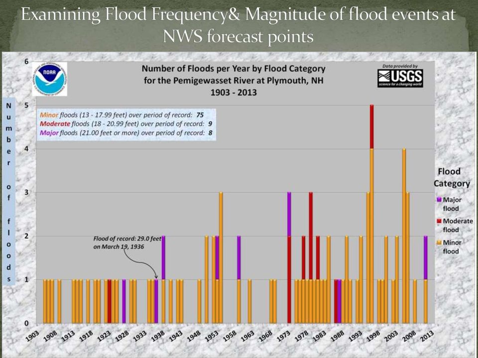
2 From a Practitioner s Perspective Touch upon some of our major flood events of the past 10 years New Hampshire is not alone Common themes & characteristics How may a changing climate be impacting storm behavior in the Northeast? What does this all mean?

3 I m not a climate scientist! I m a practitioner I have the benefit of living in this part of the country my entire life It s different now beyond temps & precip Changes in vegetation, insects, bird life & river response Sea level rise The mission: Develop a better understanding of the current regime vs. the old & what that means to how we model our rivers Accumulation of Ingredients not one single source Where we are headed: that s the million $$ question!


4 Record flooding along the Fish and Saint John Rivers northeast Maine, 4/30/2008 St-Jean-sur-Richelieu, Quebec, Canada, 5/6/11 Photo: AP//Canadian Press, R. Remoirz Providence Street West Warwick, RI at 1030 am Wednesday 3/31/10 Home washed off its foundation along the Schoharie Creek, Prattsville, NY Tropical Storm Irene

5 Several: Slow moving weather systems a blocked up atmosphere Multiple events in close succession or 1 or 2 slow movers Resulted in saturated antecedent conditions before main event Each fed by a tropical connection Plumes of deep moisture


6 Modest changes in air & sea temperatures = atmosphere can hold more moisture New England is in close proximity to the ocean and the Gulf & Atlantic moisture streams Affected by dual storm tracks and blocking high pressure over Greenland These ingredients offer us more opportunities to latch onto these plumes Reduction of sea ice changes upper level wind flow Blocked up pattern induces slower moving storms or back-to-back-to back events L L H L

 For smaller (<800 sq mi) basins trend toward increased flood magnitude and/or frequency Most pronounced where significant land use change and/or urbanization has occurred")
7 Common themes across New England: Increasing annual precipitation Increasing frequency of heavy rains Warming annual temperatures Wildly varying seasonal snowfall Shift in precipitation frequency (50, 100 yr 24 hr rain) For smaller (<800 sq mi) basins trend toward increased flood magnitude and/or frequency Most pronounced where significant land use change and/or urbanization has occurred Moderate flooding Connecticut River at Portland, CT, April 2007 I-95 in Warwick with submerged Warwick Waste Water Treatment Facility March 31, 2010 photo from RI ANG)

8 Trends in U.S. Temperature: Decadal trends and relative to

9

10 Trends in U.S. Precipitation: Decadal trends and relative to

11


12 Since the late 60s, similar signature of much shorter, less intense dry periods and longer higher amplitude wet periods

13 Change in Precipitation Patterns Intense precipitation events (the heaviest 1%) in the continental U.S. increased by 20% over the past century while total precipitation increased by 7%. Source: 13

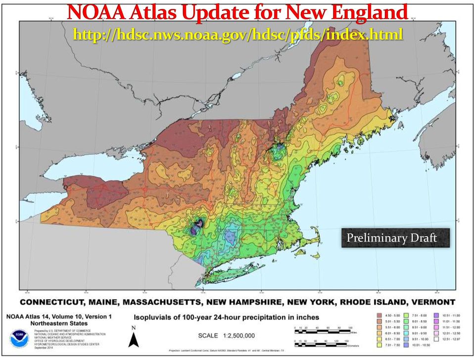
14 From the 2010 Report hr 100 yr values from TP-40, 1961 Southeast ½ of NE experience a 1 to 2 inch upward shift!

15 Preliminary Draft

16 Small watersheds feeling the effects Changes in frequency/magnitude Part land use/urbanization Compounded by encroachment in the floodplain Part changing climate Larger basins with flood control haven t seen as noticeable a shift Most USACE reservoirs are built for 6-8 inch runoff events Greater capacity to handle more rain Perkins Avenue, Warwick, RI Tuesday, March 30, 2010 Flooding along the Housatonic River following Lee, Sept 8, Photo: A. Driscoll, Connecticut Post

17 Mathias Collins NOAA NFMS Restoration center 2009 study of 28 watersheds with minimal human influences Results indicate basins in central and western Maine experienced increased peak annual flows Strongest statistical trends noted by the large blue triangles Spatial distribution of trend directions & magnitudes for based with minimal human influences. Reference: M. Collins, Journal of The American Water Resources Association (JAWRA) April 2009.

18 Mathias Collins NOAA NFMS Restoration center 2011 study of 23 watersheds with minimal human influences Examined peaks over defined thresholds per water year (direct measure of flood frequency) More frequent flooding at 22 of 23 locations Increasing flood magnitude at 17 of 23 locations Spatial Distribution of Flood Frequency as measured by peaks over threshold per water year. Reference: W. Armstrong, M. Collins, and N. Snyder Journal of The American Water Resources Association (JAWRA) April 2011.

19

20
21
22
23

24 The Northeast has become a hot spot for record floods & heavy rainfall in the past 10 years Noticeable trends include increased yearly rainfall and increased annual temperatures Southeast New Hampshire has experienced a 1.5 to 2.5 inch shift upwards in the 100 yr 24 hour rainfall Smaller watersheds & those with significant urbanization are most vulnerable to increased river & stream flooding
25 Floodplain, land use, infrastructure, dam spillway requirements, drainage requirements, non-point source runoff, bridge clearances, hardening of critical facilities in the floodplain, property values etc Flood Insurance work to increase participation How much risk are we willing to insure and accept? Graphic courtesy of Cameron Wake University of New Hampshire
26 David R. Vallee Hydrologist-in-Charge NOAA/NWS Northeast River Forecast Center Providence Street West Warwick, RI at 1030 am Wednesday 3/31/10
Climate Trends In New England and Its Impact on Storm Behavior; Riverine and Coastal Flood Impacts
 2 ND ANNUAL CAPE COASTAL CONFERENCE JUNE 6 Linking Science with Local Solutions and Decision-Making Climate Trends In New England and Its Impact on Storm Behavior; Riverine and Coastal Flood Impacts David
Flood After Fire Fact Sheet
 FACT SHEET Flood After Fire Fact Sheet Risks and Protection Floods are the most common and costly natural hazard in the nation. Whether caused by heavy rain, thunderstorms, or the tropical storms, the
SITE SPECIFIC WEATHER ANALYSIS REPORT
 SAMPLE FLOOD ANALYSIS REPORT SITE SPECIFIC WEATHER ANALYSIS REPORT PREPARED FOR: Law Offices of Oliver Wendell Douglas Oliver Wendell Douglas PREPARED BY: November 29, 2007 CASE REFERENCE: Arnold Ziffel
The IPCC Special Report on Managing the Risks of Extreme Events and Disasters to Advance Climate Change Adaptation
 The IPCC Special Report on Managing the Risks of Extreme Events and Disasters to Advance Climate Change Adaptation A changing climate leads to changes in extreme weather and climate events 2 How do changes
Climate Change on the Prairie:
 Climate Change on the Prairie: A Basic Guide to Climate Change in the High Plains Region - UPDATE Global Climate Change Why does the climate change? The Earth s climate has changed throughout history and
Heavy Rainfall from Hurricane Connie August 1955 By Michael Kozar and Richard Grumm National Weather Service, State College, PA 16803
 Heavy Rainfall from Hurricane Connie August 1955 By Michael Kozar and Richard Grumm National Weather Service, State College, PA 16803 1. Introduction Hurricane Connie became the first hurricane of the
SECTION 3.2 CLIMATE AND PRECIPITATION
 SECTION 3.2 CLIMATE AND PRECIPITATION Ulster County Climate Data A preliminary analysis of the Preserve s weather data shows that the average temperature has risen about two degrees over the past 114 years.
Projections, Predictions, or Trends?
 Projections, Predictions, or Trends? The challenges of projecting changes to fire regimes under climate change Bec Harris 9-11 th October, 2013 What are we looking for? Aims differ, and are more or less
Town of Warwick, Village of Florida, Village of Greenwood Lake and Village of Warwick MULTI JURISIDICTIONAL, MULTI HAZARD MITIGATION PLAN DRAFT
 Town of Warwick, Village of Florida, Village of Greenwood Lake and Village of Warwick MULTI JURISIDICTIONAL, MULTI HAZARD MITIGATION PLAN DRAFT Appendix B Historical Hazard Documentation Rev #0 May 2013
Using probability to understand 100-year storms
 1 + Using probability to understand 100-year storms Grade Level: 5-7 Activity Duration: 30-45 minutes Overview: I. Storm stories II. 100-year Storm Probability III. Delineating Storms in NE Minnesota Summary:
Climate Extremes Research: Recent Findings and New Direc8ons
 Climate Extremes Research: Recent Findings and New Direc8ons Kenneth Kunkel NOAA Cooperative Institute for Climate and Satellites North Carolina State University and National Climatic Data Center h#p://assessment.globalchange.gov
Antecedent Conditions:
 Antecedent Conditions: Record to Near Record Heat occurred across Northeast & North Central Colorado September 2-8. A cold front moved across Northeast Colorado the morning of the 9 th, and deeper subtropical
2013 Annual Climate Summary for the Southeast United States
 Months of heavy rain forced the U.S. Army Corp of Engineers to open the spillways at Lake Hartwell, located at the headwaters of the Savannah River along the South Carolina-Georgia border, on July 9,.
Climate Change Long Term Trends and their Implications for Emergency Management August 2011
 Climate Change Long Term Trends and their Implications for Emergency Management August 2011 Overview A significant amount of existing research indicates that the world s climate is changing. Emergency
2. The map below shows high-pressure and low-pressure weather systems in the United States.
 1. Which weather instrument has most improved the accuracy of weather forecasts over the past 40 years? 1) thermometer 3) weather satellite 2) sling psychrometer 4) weather balloon 6. Wind velocity is
Multi-Jurisdictional Hazard Mitigation Plan
 Flooding General Flooding is the leading cause of death among all types of natural disasters throughout the United States, with its ability to roll boulders the size of cars, tear out trees, and destroy
ROSE CREEK WATERSHED HYDROLOGIC, HYDRAULIC, SEDIMENT TRANSPORT, AND GEOMORPHIC ANALYSES TASK 1 EXISTING DATA AND INFORMATION SUMMARY REPORT BACKGROUND
 ROSE CREEK WATERSHED HYDROLOGIC, HYDRAULIC, SEDIMENT TRANSPORT, AND GEOMORPHIC ANALYSES TASK 1 EXISTING DATA AND INFORMATION SUMMARY REPORT BACKGROUND The Rose Creek Watershed (RCW) consists of three planning
National Dam Safety Program Technical Seminar #22. When is Flood Inundation Mapping Not Applicable for Forecasting
 National Dam Safety Program Technical Seminar #22 Thursday February 19 th 2015 Emmittsburg, MD When is Flood Inundation Mapping Not Applicable for Forecasting Victor Hom Hydrologic Services Division National
Texas Department of Public Safety Texas Division of Emergency Management. Texas State Operations Center
 Texas Department of Public Safety Texas Division of Emergency Management Texas State Operations Center Situation Awareness Brief Saturday, July 20 th 2013 As of 0900 CDT Tropical Weather Outlook For the
Basics of weather interpretation
 Basics of weather interpretation Safety at Sea Seminar, April 2 nd 2016 Dr. Gina Henderson Oceanography Dept., USNA ghenders@usna.edu Image source: http://earthobservatory.nasa.gov/naturalhazards/view.php?id=80399,
7613-1 - Page 1. Weather Unit Exam Pre-Test Questions
 Weather Unit Exam Pre-Test Questions 7613-1 - Page 1 Name: 1) Equal quantities of water are placed in four uncovered containers with different shapes and left on a table at room temperature. From which
Dirk Nyland - Chief Engineer BC Ministry of Transportation and Infrastructure NRCan - CCIAD Presentation 9 September 2014
 Considerations for Addressing Climate Change Adaptation for Transportation Infrastructure in Highway Management, Design, Operation and Maintenance in British Columbia Dirk Nyland - Chief Engineer BC Ministry
Flash Flood Science. Chapter 2. What Is in This Chapter? Flash Flood Processes
 Chapter 2 Flash Flood Science A flash flood is generally defined as a rapid onset flood of short duration with a relatively high peak discharge (World Meteorological Organization). The American Meteorological
Presented by: Michael DePue, PE, CFM Annual Georgia Association of Floodplain Management Conference Lake Lanier Islands, Georgia March 23, 2010
 Flood Types and Characteristics Presented by: Michael DePue, PE, CFM Annual Georgia Association of Floodplain Management Conference Lake Lanier Islands, Georgia March 23, 2010 Agenda Why study flood types?
Section 5 CLIMATE TABLES
 Section Section CLIMATE SOURCES OF DATA... -1 HISTORICAL CONTEXT... -1 PRECIPITATION... -2 TEMPERATURES... -3 EVAPOTRANSPIRATION... -3 WIND SPEED AND DIRECTION... -4 DEGREE DAYS...-4 CONCLUSIONS AND RECOMMENDATIONS...
FLOOD FORECASTING PRACTICE IN NORTHERN CALIFORNIA
 FLOOD FORECASTING PRACTICE IN NORTHERN CALIFORNIA California Department of Water Resources Post Office Box 219000, Sacramento, California 95821 9000 USA By Maurice Roos, Chief Hydrologist ABSTRACT Although
CLIMATE, WATER & LIVING PATTERNS THINGS
 CLIMATE, WATER & LIVING PATTERNS NAME THE SIX MAJOR CLIMATE REGIONS DESCRIBE EACH CLIMATE REGION TELL THE FIVE FACTORS THAT AFFECT CLIMATE EXPLAIN HOW THOSE FACTORS AFFECT CLIMATE DESCRIBE HOW CLIMATES
sample The IPCC Special Report on Managing the Risks of Extreme Events and Disasters to Advance Climate Change Adaptation
 sample The IPCC Special Report on Managing the Risks of Extreme Events and Disasters to Advance Climate Change Adaptation A changing climate leads to changes in extreme weather and climate events 2 Impacts
Burnt River Black River and Gull River Flood Contingency Plan
 Burnt River Black River and Gull River Flood Contingency Plan Objective: The objective of this plan is to preplan and prepare for flooding events in the Burnt River, Black River and Gull River area of
Climate of Illinois Narrative Jim Angel, state climatologist. Introduction. Climatic controls
 Climate of Illinois Narrative Jim Angel, state climatologist Introduction Illinois lies midway between the Continental Divide and the Atlantic Ocean, and the state's southern tip is 500 miles north of
Next Generation Flood Alert in Houston
 Next Generation Flood Alert in Houston Philip B. Bedient Civil and Environmental Eng., Rice University Houston, TX Major Causes of Urban Flooding (Excess Water that Inundates) Highly Developed (urbanized)
Reservoir Simulations for the Delaware River Basin Flood of June, 2006
 Reservoir Simulations for the Delaware River Basin Flood of June, 2006 Middle Atlantic River Forecast Center State College, PA August 2007 (Revised 9/13/07) Introduction: In the late spring of 2005, the
DRAFT NATIONAL ACTION PLAN:
 DRAFT NATIONAL ACTION PLAN: PRIORITIES FOR MANAGING FRESHWATER RESOURCES IN A CHANGING CLIMATE INTERAGENCY CLIMATE CHANGE ADAPTATION TASK FORCE June 2, 2011 The Mississippi River at Lansing, Iowa Photo
Climate Change and Infrastructure Planning Ahead
 Climate Change and Infrastructure Planning Ahead Climate Change and Infrastructure Planning Ahead Infrastructure the physical facilities that support our society, such as buildings, roads, railways, ports
WEATHER AND CLIMATE WHY DOES IT MATTER?
 WEATHER AND CLIMATE Rising global average temperature is associated with widespread changes in weather patterns. Scientific studies indicate that extreme weather events such as heat waves and large storms
Argonne National Laboratory
 Argonne National Laboratory Using Climate Data to Inform Critical Infrastructure Resilience and Urban Sustainability Decisionmaking National Academy of Sciences Roundtable on Science and Technology for
Climate, Drought, and Change Michael Anderson State Climatologist. Managing Drought Public Policy Institute of California January 12, 2015
 Climate, Drought, and Change Michael Anderson State Climatologist Managing Drought Public Policy Institute of California January 12, 2015 Oroville Reservoir January 2009 Presentation Overview The Rules
THE SEARCH FOR T RENDS IN A GLOBAL CATALOGUE
 THE SEARCH FOR T RENDS IN A GLOBAL CATALOGUE OF NORMALIZED W EATHER-RELATED CATASTROPHE LOSSES Robert-Muir Wood, Stuart Miller, Auguste Boissonade Risk Management Solutions London, UK Abstract I n order
Climate Change. Lauma M. Jurkevics - DWR, Southern Region Senior Environmental Scientist
 Climate Change A n o t h e r F a c t o r i n M a n a g i n g S o u t h e r n C a l i f o r n i a s W a t e r R e s o u r c e s Lauma M. Jurkevics - DWR, Southern Region Senior Environmental Scientist USEPA-Region
Facing an Uncertain Future: Increasing Resilience at Marinas and Harbors. Recreational Boating Educational Conference December 11, 2014
 Facing an Uncertain Future: Increasing Resilience at Marinas and Harbors Recreational Boating Educational Conference December 11, 2014 Operators Face Change and Challenges Environmental Conditions Fluctuating
How To Predict Climate Change
 A changing climate leads to changes in extreme weather and climate events the focus of Chapter 3 Presented by: David R. Easterling Chapter 3:Changes in Climate Extremes & their Impacts on the Natural Physical
ARkStorm: California s Other Big One!
 ARkStorm: California s Other Big One! Understanding the Impacts of Massive Winter Storms Mark Jackson Meteorologist in Charge NOAA/National Weather Service Los Angeles/Oxnard What is ARkStorm? Emergency-preparedness
climate science A SHORT GUIDE TO This is a short summary of a detailed discussion of climate change science.
 A SHORT GUIDE TO climate science This is a short summary of a detailed discussion of climate change science. For more information and to view the full report, visit royalsociety.org/policy/climate-change
Geography affects climate.
 KEY CONCEPT Climate is a long-term weather pattern. BEFORE, you learned The Sun s energy heats Earth s surface unevenly The atmosphere s temperature changes with altitude Oceans affect wind flow NOW, you
Types of flood risk. What is flash flooding? 3/16/2010. GG22A: GEOSPHERE & HYDROSPHERE Hydrology. Main types of climatically influenced flooding:
 GG22A: GEOSPHERE & HYDROSPHERE Hydrology Types of flood risk Main types of climatically influenced flooding: 1. Flash (rapid-onset) 2. Lowland (slow-rise) 3. Coastal (not covered here) But! Causal factors
Deke Arndt Climate Monitoring Branch Na6onal Clima6c Data Center 25 June 2013
 Deke Arndt Climate Monitoring Branch Na6onal Clima6c Data Center 25 June 2013 The National Climatic Data Center The World s Largest Archive of Weather & Climate Data NCDC is located in Asheville, North
[ Climate Data Collection and Forecasting Element ] An Advanced Monitoring Network In Support of the FloodER Program
![[ Climate Data Collection and Forecasting Element ] An Advanced Monitoring Network In Support of the FloodER Program](/thumbs/33/16326315.jpg "[ Climate Data Collection and Forecasting Element ] An Advanced Monitoring Network In Support of the FloodER Program") [ Climate Data Collection and Forecasting Element ] An Advanced Monitoring Network In Support of the FloodER Program December 2010 1 Introduction Extreme precipitation and the resulting flooding events
[ Climate Data Collection and Forecasting Element ] An Advanced Monitoring Network In Support of the FloodER Program December 2010 1 Introduction Extreme precipitation and the resulting flooding events
THE FOUR RIVERS RESTORATION PROJECT AND ITS IMPLICATIONS TO THE CHAO PHRAYA RIVER
 KOREA S EXEMPLARY CASE OF FLOOD PREVENTION THE FOUR RIVERS RESTORATION PROJECT AND ITS IMPLICATIONS TO THE CHAO PHRAYA RIVER Office of National River Restoration, Korea MLTM Republic of Korea CONTENTS
Assiniboine River and Lake Manitoba Basins Flood Mitigation Study: Providing Greater Protection For Manitobans From Flood Risks
 Assiniboine River and Lake Manitoba Basins Flood Mitigation Study: Providing Greater Protection For Manitobans From Flood Risks Welcome! Manitoba Infrastructure and Transportation is studying flooding
Climate Change Adaptation in London. Alex Nickson, Policy & Programmes Manager Climate Change Adaptation & Water, Greater London Authority
 Climate Change Adaptation in London Alex Nickson, Policy & Programmes Manager Climate Change Adaptation & Water, Greater London Authority Why adapt? We are not very well adapted to our existing climate
The AIR Inland Flood Model for the United States In Spring 2011, heavy rainfall and snowmelt produced massive flooding along the Mississippi River,
 The AIR Inland Flood Model for the United States In Spring 2011, heavy rainfall and snowmelt produced massive flooding along the Mississippi River, inundating huge swaths of land across seven states. As
POTENTIAL IMPACTS OF CLIMATE CHANGE ON FLOODING IN WISCONSIN
 POTENTIAL IMPACTS OF CLIMATE CHANGE ON FLOODING IN WISCONSIN Ken Potter and Zach Schuster Department of Civil & Environmental Engineering University of Wisconsin Madison, WI OUTLINE Typical flood scenarios
Stormwater management around the world Lessons from Novatech 2010 Dennis Corbett and Marion Urrutiaguer
 Stormwater management around the world Lessons from Novatech 2010 Dennis Corbett and Marion Urrutiaguer Novatech 2010, the 7th international conference on sustainable techniques and strategies in urban
Standard Operating Procedures for Flood Preparation and Response
 Standard Operating Procedures for Flood Preparation and Response General Discussion Hurricanes, tropical storms and intense thunderstorms support a conclusion that more severe flooding conditions than
Development of Technical Data For Long Term Flood Solutions For the Red River Basin
 IDENTIFYING WHAT WE DIDN T KNOW Development of Technical Data For Long Term Flood Solutions For the Red River Basin LTFS Study Area U.S. Portion of Red River Basin (MN, ND & SD) Main Stem Red River Tributaries
Climate Change in North Carolina
 Climate Change in North Carolina Dr. Chip Konrad Director of the The Southeast Regional Climate Center Associate Professor Department of Geography University of North Carolina at Chapel Hill The Southeast
Monsoon Variability and Extreme Weather Events
 Monsoon Variability and Extreme Weather Events M Rajeevan National Climate Centre India Meteorological Department Pune 411 005 rajeevan@imdpune.gov.in Outline of the presentation Monsoon rainfall Variability
Design and Deployment of Specialized Visualizations for Weather-Sensitive Electric Distribution Operations
 Fourth Symposium on Policy and Socio-Economic Research 4.1 Design and Deployment of Specialized Visualizations for Weather-Sensitive Electric Distribution Operations Lloyd A. Treinish IBM, Yorktown Heights,
Great Plains and Midwest Climate Outlook 19 March 2015
 Great Plains and Midwest Climate Outlook 19 March 2015 Wendy Ryan Assistant State Climatologist Colorado State University wendy.ryan@colostate.edu Grass fire in SE Nebraska 13 March 2015 General Information
Climate, Vegetation, and Landforms
 Climate, Vegetation, and Landforms Definitions Climate is the average weather of a place over many years Geographers discuss five broad types of climates Moderate, dry, tropical, continental, polar Vegetation:
21 st Century Approaches to CSO & Water Quality Restoration. Paul L. Freedman, P.E., BCEE
 21 st Century Approaches to CSO & Water Quality Restoration Paul L. Freedman, P.E., BCEE Wet Weather Partnership & NACWA April 26-27, 2007 Burning Cuyahoga Traditional CWA Approach to Water Quality Protection,
Please see the Seasonal Changes module description.
 Overview Children will measure and graph the precipitation on the playground throughout the year using a rain gauge. Children will also observe satellite images of clouds and begin to investigate how clouds
WEATHER AND CLIMATE practice test
 WEATHER AND CLIMATE practice test Multiple Choice Identify the choice that best completes the statement or answers the question. 1. What role does runoff play in the water cycle? a. It is the process in
Jessica Blunden, Ph.D., Scientist, ERT Inc., Climate Monitoring Branch, NOAA s National Climatic Data Center
 Kathryn Sullivan, Ph.D, Acting Under Secretary of Commerce for Oceans and Atmosphere and NOAA Administrator Thomas R. Karl, L.H.D., Director,, and Chair of the Subcommittee on Global Change Research Jessica
Vulnerability Assessment of New England Streams: Developing a Monitoring Network to Detect Climate Change Effects
 Vulnerability Assessment of New England Streams: Developing a Monitoring Network to Detect Climate Change Effects National Water Quality Monitoring Council 2012 Meeting Britta Bierwagen, National Center
Prattsville Berm Removal Project. 1.0 Project Location
 Prattsville Berm Removal Project 1.0 Project Location The project site is located between the New York State Route 23 Bridge over the Schoharie Creek and the Schoharie Reservoir. The restoration plan encompassed
COMMON CORE Lessons & Activities
 T E AC H I T SA M PL E COMMON CORE Lessons & Activities DAY! O T Common Core Lessons & Activities: Weather By Carole Marsh Published by Gallopade International, Inc. Carole Marsh/Gallopade Printed in the
CGC1D1: Interactions in the Physical Environment Factors that Affect Climate
 Name: Date: Day/Period: CGC1D1: Interactions in the Physical Environment Factors that Affect Climate Chapter 12 in the Making Connections textbook deals with Climate Connections. Use pages 127-144 to fill
AZ EGER-PATAK HIDROLÓGIAI VIZSGÁLATA, A FELSZÍNI VÍZKÉSZLETEK VÁRHATÓ VÁLTOZÁSÁBÓL ADÓDÓ MÓDOSULÁSOK AZ ÉGHAJLATVÁLTOZÁS HATÁSÁRA
 AZ EGER-PATAK HIDROLÓGIAI VIZSGÁLATA, A FELSZÍNI VÍZKÉSZLETEK VÁRHATÓ VÁLTOZÁSÁBÓL ADÓDÓ MÓDOSULÁSOK AZ ÉGHAJLATVÁLTOZÁS HATÁSÁRA GÁBOR KEVE 1, GÉZA HAJNAL 2, KATALIN BENE 3, PÉTER TORMA 4 EXTRAPOLATING
Healthy Forests Resilient Water Supply Vibrant Economy. Ecological Restoration Institute
 Healthy Forests Resilient Water Supply Vibrant Economy Ecological Restoration Institute How Water Gets to Your Home MOST OF THE VALLEY S WATER SUPPLY comes from winter precipitation and runoff from Arizona
Critical Assets and Extreme Weather Process & Lessons
 Critical Assets and Extreme Weather Process & Lessons Steven Olmsted Intermodal Transportation Division Arizona Department of Transportation 2014 Transportation Asset Management Conference April 28-30,
Hydrologic Engineering Techniques for Regional Water Resources Planning
 US Army Corps of Engineers Hydrologic Engineering Center Hydrologic Engineering Techniques for Regional Water Resources Planning October 1969 Approved for Public Release. Distribution Unlimited. TP-17
FOUR RIVERS RESTORATION PROJECT
 MLTM Republic of Korea Making Every Drop Count International Workshop on Integrated Urban Water Management WATER & GREEN GROWTH FOUR RIVERS RESTORATION PROJECT Office of National River Restoration, Korea
Arizona Climate Summary February 2015 Summary of conditions for January 2015
 Arizona Climate Summary February 2015 Summary of conditions for January 2015 January 2015 Temperature and Precipitation Summary January 1 st 14 th : January started off with a very strong low pressure
Methods for Determination of Safe Yield and Compensation Water from Storage Reservoirs
 US Army Corps of Engineers Hydrologic Engineering Center Methods for Determination of Safe Yield and Compensation Water from Storage Reservoirs October 1966 Approved for Public Release. Distribution Unlimited.
CRS 610 Ventura County Flood Warning System Website
 CRS 610 Ventura County Flood Warning System Website Purpose This document gives instructions and a description of the information available via the Ventura County Watershed Protection District s (VCWPD)
How To Predict Climate Change In Tonga
 Niuatoputapu Niuafo'ou Late Island Vava u Group South Pacific Ocean Tofua Island Kotu Group Nomuka Group Ha apai Group NUKU ALOFA Eua Island Tongatapu Group Current and future climate of Tonga > Tonga
The State of the Climate And Extreme Weather. Deke Arndt NOAA s National Climatic Data Center
 The State of the Climate And Extreme Weather Deke Arndt June Feb 2013 2011 1 The world s largest archive of weather and climate data NCDC is located in Asheville, North Carolina A place of active retirement
Pennsylvania Flood Safety Awareness Week March 6-10th, 2015
 Pennsylvania Flood Safety Awareness Week March 6-10th, 2015 David J. Nicosia Warning Coordination Meteorologist National Weather Service Binghamton, NY Flooding is a coast to coast threat to the United
Climate vulnerability assessment Risks from urban flooding Interactive science and policy assessment
 Climate vulnerability assessment Risks from urban flooding Interactive science and policy assessment Flood risk from extreme precipitation in Copenhagen - Modelling results Per Skougaard Kaspersen, DTU
10/4/2012. 40 slide sample of Presentation. Key Principles to Current Stormwater Management
 40 slide sample of Presentation Please contact mhoalton@pacewater.com if you would like the complete presentation Key Principles to Current Stormwater Management Distributed Control Measures Integrated
FACTS ABOUT CLIMATE CHANGE
 FACTS ABOUT CLIMATE CHANGE 1. What is climate change? Climate change is a long-term shift in the climate of a specific location, region or planet. The shift is measured by changes in features associated
THE ECOSYSTEM - Biomes
 Biomes The Ecosystem - Biomes Side 2 THE ECOSYSTEM - Biomes By the end of this topic you should be able to:- SYLLABUS STATEMENT ASSESSMENT STATEMENT CHECK NOTES 2.4 BIOMES 2.4.1 Define the term biome.
Preliminary advances in Climate Risk Management in China Meteorological Administration
 Preliminary advances in Climate Risk Management in China Meteorological Administration Gao Ge Guayaquil,Ecuador, Oct.2011 Contents China Framework of Climate Service Experience in Climate/disaster risk
Flood Facts 2F.1. Flood Facts
 Flood Facts 2F.1 Engage Flood Facts To introduce students to the causes and effects of flooding in Western Australia. Flooding occurs in the Australian environment as part of the natural water or hydrologic
5.14 Floodplains and Drainage/Hydrology
 I-70 East Final EIS 5.14 Floodplains and Drainage/Hydrology 5.14 Floodplains and Drainage/Hydrology This section discusses floodplain and drainage/hydrology resources and explains why they are important
Armenian State Hydrometeorological and Monitoring Service
 Armenian State Hydrometeorological and Monitoring Service Offenbach 1 Armenia: IN BRIEF Armenia is located in Southern Caucasus region, bordering with Iran, Azerbaijan, Georgia and Turkey. The total territory
Standardized Runoff Index (SRI)
") Standardized Runoff Index (SRI) Adolfo Mérida Abril Javier Gras Treviño Contents 1. About the SRI SRI in the world Methodology 2. Comments made in Athens on SRI factsheet 3. Last modifications of the factsheet
Standardized Runoff Index (SRI) Adolfo Mérida Abril Javier Gras Treviño Contents 1. About the SRI SRI in the world Methodology 2. Comments made in Athens on SRI factsheet 3. Last modifications of the factsheet
Adaptation to a Changing Climate
 Adaptation to a Changing Climate City Infrastructure Preparedness David MacLeod City of Toronto Environment Office March 3, 2011 WHAT IS CITY INFRASTRUCTURE? Physical (Hard) Infrastructure Buildings Municipal
South Africa. General Climate. UNDP Climate Change Country Profiles. A. Karmalkar 1, C. McSweeney 1, M. New 1,2 and G. Lizcano 1
 UNDP Climate Change Country Profiles South Africa A. Karmalkar 1, C. McSweeney 1, M. New 1,2 and G. Lizcano 1 1. School of Geography and Environment, University of Oxford. 2. Tyndall Centre for Climate
Southern AER Atmospheric Education Resource
 Southern AER Atmospheric Education Resource Vol. 9 No. 5 Spring 2003 Editor: Lauren Bell In this issue: g Climate Creations exploring mother nature s remote control for weather and Climate. g Crazy Climate
Queensland rainfall past, present and future
 Queensland rainfall past, present and future Historically, Queensland has had a variable climate, and recent weather has reminded us of that fact. After experiencing the longest drought in recorded history,
Flooding in Singapore: An Overview
 Flooding in Singapore: An Overview FUTURE FLOODS: An Exploration of a Cross-Disciplinary Approach to Flood Risk Forecasting Prepared by Claire Kennedy of Impact Forecasting Agenda Section 1 Section 2 Section
Risk and vulnerability assessment of the build environment in a dynamic changing society
 Risk and vulnerability assessment of the build environment in a dynamic changing society Limnei Nie SINTEF Building and infrastructure, P.O.Box 124 Blindern, NO-0314 Oslo, Norway. linmei.nie@sintef.no
Pre-Kyle Severe Flooding Across Southeastern Puerto Rico
 Althea Austin-Smith Service Hydrologist San Juan, Puerto Rico Notes I want to acknowledge members of our staff for assistance with graphics photos etc. Inland Flooding While storm surge is always a potential
6. Base your answer to the following question on the graph below, which shows the average monthly temperature of two cities A and B.
 1. Which single factor generally has the greatest effect on the climate of an area on the Earth's surface? 1) the distance from the Equator 2) the extent of vegetative cover 3) the degrees of longitude
RE: James vs. ABC Company Greentown, NJ D/A: February 20, 2011
 PO Box 7100 Hackettstown, NJ 07840 Phone: 1 800 427 3456 Fax: 908-850-8664 http://www.weatherworksinc.com June 16, 2012 Attn: John Doe Law Offices of John Doe 123 Fourth Street Smithtown, NJ 04506 RE:
Screening Transportation Assets for Vulnerability
 Screening Transportation Assets for Vulnerability Impacts of Climate Change and Variability on Transportation Systems & Infrastructure (Gulf Coast Study, Phase 2) FHWA Office of Planning Environment and
Agenda Northeast Regional Operational Workshop XIV Albany, New York Tuesday, December 10, 2013
 Agenda Northeast Regional Operational Workshop XIV Albany, New York Tuesday, December 10, 2013 10:00 am Welcoming Remarks Raymond G. O Keefe, Meteorologist In Charge Warren R. Snyder, Science & Operations
Flood risk assessment through a detailed 1D/2D coupled model
 CORFU Project Barcelona Case Study Final Workshop 19 th of May 2014 Flood risk assessment through a detailed 1D/2D coupled model Beniamino Russo Aqualogy Urban Drainage Direction Introduction and general