Laser Scanning Surveying and Ground Penetrating Radar The Full Three Dimensional Picture Above and Below Ground
|
|
|
- Adam Townsend
- 7 years ago
- Views:
Transcription
1 Laser Scanning Surveying and Ground Penetrating Radar The Full Three Dimensional Picture Above and Below Ground

2 CIVILEX 2009 Mark Hudson, Director, Coastway, FInstCES MRICS MIS BTS Jeff Hott, Laser Scanning & Survey Manager, Coastway, BSc Dr James Hodgson, Senior Geophysicist, Minerex, Phd BSc

3 Laser Scanning Surveying & Ground Penetrating Radar The full 3 dimensional picture - above and below ground Bring the added deliverable benefits of surface topographical laser scanning to the underground world of utilities Surface laser scanning Ground Penetrating Radar 2D to 3D Sub-surface laser scanning The full picture - 3D model deliverable in 'real co-ordinates'

4 Coastway Ltd. Coastway are the leading Geospatial Engineering surveying company in Ireland covering the following sectors: Geospatial Engineering High Definition Laser Scanning Structural Monitoring Environmental Monitoring Ground Penetrating Radar 3D Modelling & Visualisation Minerex are leading Ground Penetrating Radar geophysicists

5 Minerex Geophysics Ltd. Minerex Geophysics Ltd. are a specialist geophysical and utility mapping consultancy. Our experienced geophysical staff have over 20 years experience in all aspects of geophysical surveying and consultancy. Geophysical Services Consulting Surveying Data Processing Interpretation Reporting Project Management Dr. James A. Hodgson Unit F4, Maynooth Business Campus, Maynooth, Co. Kildare, Ireland TEL: FAX: e mail: Info@mgx.ie

6 Ground Penetrating Radar GPR is an electromagnetic (EM) geophysical method which is non destructive EM energy is transmitting into the ground and a receiver measures energy that is reflected back to the surface from a buried body or interface Very useful for locating buried object pipes, ducts, watermains, gas lines etc and defining subsurface structures.

7 GPR Principle of Operation

8 Top 400 MHz, Bottom 900 MHz GPR 2D Example section

9 Minerex Geophysics Ltd operates a GSSI SIR 3000 system 400MHz Antenna in hand towed configuration In average Irish soil conditions penetrates to 1 1.5m, possibly 2.5 3m GPR Equipment

10 GPR Equipment Minerex Geophysics Ltd operates a GSSI SIR 3000 system 270MHz antenna ~ 4 5m penetration 100 MHz 6 9m penetration

11 GPR Grids
12 GPR Geological Mapping

13 GPR Cavity/Void Detection

14 GPR Basements/Coal Stores

15 GPR 3D Depth Slice GPR data collected in a series of profiles / grid data can be processed as a series of depth slices or as a 3D data Cube.

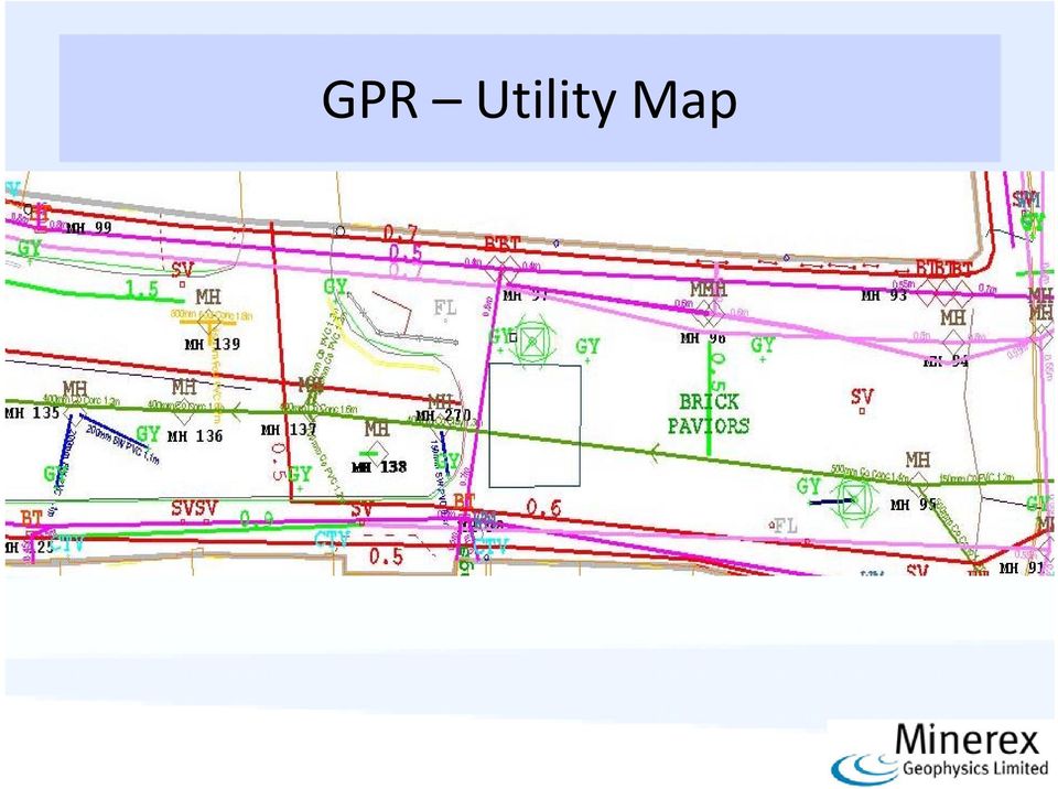
16 GPR Utility Map
17 3D GPR CAD Image

18 Laser Scanning Laser Scanning is a method of collecting large numbers of survey points in a relatively short space of time. The principle of measurement is the same as conventional EDM total station measurement technology in that the laser scanner emits a laser beam and then measures the angle and distance of the return laser beam by extremely accurately measuring of the time of the return laser beam. However a laser scanner can capture data at up to 500,000 points/second as opposed to single point measurements with a reflectorless total station. High definition 3D Laser Scanning is unparalleled in the capture of large numbers of points in a grid system that can be defined by the operator. The density of this point grid allows the analysis of deflection and movement in areas not possible to be determined by conventional methods. It is possible to create a surface model of the point cloud data that will accurately reflect the surface of the scanned area. Changes in the surface can be measured, analysed and compared to previous surveys and relative to a specific plane.

19 HDS Laser Scanning Applications Fast, Accurate, Detailed Geometry Capture of Sites, Scene and Structures Building & Heritage As built 3D models As built 2D drawings Full colour visualisation Industrial Plant Intelligent 3D CAD as builts Revamp design clash detection Construction planning Civil & Survey Topographic road, rail surveys Volumes Tunnel surveys Forensics Crash investigation Collapse analysis Security planning

20 Utility Chamber Surveys Applications Providing accurate measurable point cloud data Condition surveys of the access chambers Incoming/Outgoing pipe locations with diameters

21 Previous Methods Photographic Evidence Sketches Confined Area Training 2D Plan Drawings
22 HDS Scanning Method Applications HDS 6000 Laser Scanner Phased base scanner with the ability to scan 500k points per second. Inverted Tri-pod Lower the scanner to between 3 and 4 metres Remote Access Control the scanner by cable or by wireless connection
23 Utility Chamber Surveys Benefits Faster, safer, more accurate, and more complete surveys of underground chambers Non-contact, remote survey reduces potential health and safety risks and improves survey safety Reduces site visits needed for data capture Full-3D point cloud dataset
24 Above and Below Ground Data Complete Survey Redundant Data Set
25 Above and Below Ground Data
26 Deliverables Point Cloud Data Cloudworx Other Software; GeoMagic, Pointools, etc ASCII Data X,Y & Z Coordinates Tab, Space or Comma Delimited Modelled Pipe Runs Automatic Pipe Creation Combine GPR and Laser Scan Data Cross Sections Create Sections to Specific Thickness Step Through Data for Analysis Quickly Generate CAD Linework Modelled Surfaces Model Point Cloud Data such as Roads, Buildings and Footpaths Generate Grid of Levels 2D and 3D Drawings Simple Plan Drawings Create 3D Linework of Features Overlay Point Cloud with OSI Data Video Flythru s Presentations Planning TruViews Extract Real 3D Coordinates Easy to Use Free to End User
27 3D Modelled Pipes
28 Cross Sections
29 2D Plan Drawings
30 3D Drawings
31 Modelled Surfaces Mesh Model Created From Laser Scan Point Cloud Data Grid of Points at 100mm Spacing Created From The Mesh Model
32 TruView Extract Real 3D Coordinates Accurately Measure Distances Save And Share Views And Mark-ups Easy Measuring, Markups and Hyperlinks View TruView File Sets Locally Or Via The Web TruView Is Available As A Free Download
33 TruView
34 Contact Details Toughers Business Park Newhall Naas, Co. Kildare, Ireland TEL: FAX: Unit F4, Maynooth Business Campus, Maynooth, Co. Kildare, Ireland TEL: FAX:
3D Laser Scanning Technology. Rugged hardware and powerful software combined with streamlined survey workflow
 3D Laser Scanning Technology Rugged hardware and powerful software combined with streamlined survey workflow Maptek specialises in the research, development and application of 3D laser scanning technology.
DAMAGED ROAD TUNNEL LASER SCANNER SURVEY
 University of Brescia - ITALY DAMAGED ROAD TUNNEL LASER SCANNER SURVEY Prof. Giorgio Vassena giorgio.vassena@unibs.it WORKFLOW - Demand analysis - Instruments choice - On field operations planning - Laser
Matt Harris, Golder Associates (NZ) Ltd. The value of geophysics as a non-intrusive method for site characterisation
 Ltd. The value of geophysics as a non-intrusive method for site characterisation") Matt Harris, Golder Associates (NZ) Ltd. The value of geophysics as a non-intrusive method for site characterisation Presentation Outline What is geophysics and how can it help me? Electrical Resistivity
Matt Harris, Golder Associates (NZ) Ltd. The value of geophysics as a non-intrusive method for site characterisation Presentation Outline What is geophysics and how can it help me? Electrical Resistivity
This presentation reports on the progress made during the first year of the Mapping the Underworld project. As multiple Universities and Departments
 This presentation reports on the progress made during the first year of the Mapping the Underworld project. As multiple Universities and Departments are involved with the project, a single speaker will
COBRA WiFi. 2 CHANNEL GPR Detect both shallow and deep pipes
 COBRA WiFi 2 CHANNEL GPR Detect both shallow and deep pipes WiFi operation no cables needed Dual Channel GPR, 250/500 MHz Complete GPR-system all inclusive Included Post Processing Software GPS Path Finder
MONITORING THE GPR RESPONSE OF CURING CONCRETE T. De Souza 1, A.P. Annan 1, J.D. Redman 1, and N. Hu 1 1 Sensors & Software Inc., Mississauga, Canada
 MONITORING THE GPR RESPONSE OF CURING CONCRETE T. De Souza 1, A.P. Annan 1, J.D. Redman 1, and N. Hu 1 1 Sensors & Software Inc., Mississauga, Canada Abstract: Ground penetrating radar (GPR) is becoming
technical notes trimble realworks software
 technical notes trimble realworks software A POWERFUL 3D LASER SCANNING OFFICE SOFTWARE SUITE Designed for today s multifaceted scanning professional, Trimble RealWorks is a powerful office software that
Thickness estimation of road pavement layers using Ground Penetrating Radar
 Dr. Eng. Audrey Van der Wielen Environment Concrete Roads Geotechnics & Surface Characteristics Division Belgian Road Research Centre (BRRC) a.vanderwielen@brrc.be Thickness estimation of road pavement
Trimble Realworks Software
 TECHNICAL NOTES Trimble Realworks Software A Powerful 3D Laser Scanning Office Software Suite DESIGNED FOR TODAY S MULTIFACETED SCANNING PROFESSIONAL, TRIMBLE REALWORKS IS A POWERFUL OFFICE SOFTWARE THAT
DOCUMENTATION AND VISUALIZATION OF AN AS-BUILT TUNNEL BY COMBINING 3D LASER SCANNING AND WEB MAPPING
 DOCUMENTATION AND VISUALIZATION OF AN AS-BUILT TUNNEL BY COMBINING 3D LASER SCANNING AND WEB MAPPING Chengyi Zhang a, *, David Arditi b, Zhong Chen c a Graduate student, Dept. of Civil, Architectural,
Ground Penetrating Radar Survey of a Portion of the Riverside Cemetery, Hopkinsville, Kentucky
 Ground Penetrating Radar Survey of a Portion of the Riverside Cemetery, Hopkinsville, Kentucky October 2012 Report prepared by Anthony L. Ortmann, Ph.D. Assistant Professor Department of Geosciences Murray
F A R O L a s e r S c a n n e r F o c u s 3 D
 F A R O L a s e r S c a n n e r F o c u s 3 D 02 The World s Most Advanced 3D Laser Scanner 04 A Revolution in 3D Laser Scanning 06 A Multitude of Features 08 Real-World Applications 22 The New SCENE 24
Specifying Laser Scanning Services. A Quantapoint White Paper
 A Quantapoint White Paper ABSTRACT Specifying Laser Scanning Services to Help Ensure Trusted and Accurate Results As-built documentation created using laser scanning is rapidly being adopted as the tool
IP-S3 HD1. Compact, High-Density 3D Mobile Mapping System
 IP-S3 HD1 Compact, High-Density 3D Mobile Mapping System Integrated, turnkey solution Ultra-compact design Multiple lasers minimize scanning shades Unparalleled ease-of-use No user calibration required
www.smap3d Plant Design.com
 www.smap3d Plant Design.com Successful projects with Smap3D Plant Design "Our partner has solved all questions of detail with a homogenous complete solution. We are already impressed by the usability and
RIEGL VZ-400 NEW. Laser Scanners. Latest News March 2009
 Latest News March 2009 NEW RIEGL VZ-400 Laser Scanners The following document details some of the excellent results acquired with the new RIEGL VZ-400 scanners, including: Time-optimised fine-scans The
Proper Implementation of Industrial CT Scanning to Reduce Inspection Costs & Get to Production Faster. Jesse Garant, JG&A Metrology Center
 Proper Implementation of Industrial CT Scanning to Reduce Inspection Costs & Get to Production Faster Jesse Garant, JG&A Metrology Center Traditional Metrology and Inspection Tactile Devices (Touch Probe)
A new approach to rail asset management.
 A new approach to rail asset management. Geotechnical and structural monitoring via satellite for the rail industry. With mounting pressures on the UK s ageing infrastructure networks from ever increasing
Automotive Applications of 3D Laser Scanning Introduction
 Automotive Applications of 3D Laser Scanning Kyle Johnston, Ph.D., Metron Systems, Inc. 34935 SE Douglas Street, Suite 110, Snoqualmie, WA 98065 425-396-5577, www.metronsys.com 2002 Metron Systems, Inc
I-SiTE - Laser Scanning Revolutionises Site Survey
 I-SiTE - Laser Scanning Revolutionises Site Survey I.K. Kapageridis Maptek/KRJA Systems Ltd, United Kingdom ABSTRACT: MAPTEK's revolutionary I-SiTE 3D Laser Imaging System, presented in this paper, is
Geophysical Survey at MIMA, The Bull Tavern Site Lexington, MA 2010. Draft
 Geophysical Survey at MIMA, The Bull Tavern Site Lexington, MA 2010. Draft By William A. Griswold, Ph.D., RPA Archeologist, National Park Service Northeast Region Archeology Program Heritage Preservation,
Figure 1: SITCRIM location. Thirteenth International Congress of the Brazilian Geophysical Society
 First Brazilian Federal Police Test Site for Forensic Geophysical Research BLUM, Marcelo de Lawrence Bassay, Departamento de Polícia Federal CAVALCANTI, Márcio Maciel, Universidade de Brasília RUSSO, Daniel,
hs2 Ground A non-technical guide
 hs2 Ground Investigations A non-technical guide Contents HS2 ground investigations 1 Essential Q&A 2 2 In-ground investigation techniques 9 2.1 Cable percussion borehole 10 2.2 Rotary core borehole 12
Moultrie Group Subsurface Geophysical Surveys
 Moultrie Group Subsurface Geophysical Surveys Martin Brook Moultrie Geology, Banyo, Brisbane, QLD 04 37887 362 mbrook@moultrie.com.au Subsurface Geophysical Surveys Martin Brook / Senior Project Geologist
Kwan Lam CHOW, HKSAR, China
 Engineering Survey Applications of Terrestrial Laser Scanner in Highways Department of the Government of Kwan Lam CHOW, HKSAR, China Key words: Terrestrial Laser Scanner SUMMARY This paper describes about
GPR Polarization Simulation with 3D HO FDTD
 Progress In Electromagnetics Research Symposium Proceedings, Xi an, China, March 6, 00 999 GPR Polarization Simulation with 3D HO FDTD Jing Li, Zhao-Fa Zeng,, Ling Huang, and Fengshan Liu College of Geoexploration
EFCOG Best Practice #84. Point of Contact: David Inskeep, (208) 526-4724, david.inskeep@inl.gov or Clark Scott, (208) 526-2919, clark.scott@inl.
 526-4724, david.inskeep@inl.gov or Clark Scott, (208) 526-2919, clark.scott@inl.") EFCOG Best Practice #84 Best Practice Title: Subsurface Investigations Facility: Idaho National Laboratory Point of Contact: David Inskeep, (208) 526-4724, david.inskeep@inl.gov or Clark Scott, (208) 526-2919,
EFCOG Best Practice #84 Best Practice Title: Subsurface Investigations Facility: Idaho National Laboratory Point of Contact: David Inskeep, (208) 526-4724, david.inskeep@inl.gov or Clark Scott, (208) 526-2919,
Application Example: Quality Control. Turbines: 3D Measurement of Water Turbines
 Application Example: Quality Control Turbines: 3D Measurement of Water Turbines Measuring Systems: ATOS, TRITOP Keywords: Kaplan, Francis, Pelton, angles 3D scanning of turbines was performed successfully
Software solutions for Lynxs, Ilris and ALTM sensors data fusion Matteo Sgrenzaroli, Eng Phd, - Marco Fiocco Eng Giorgio Vassena, Prof.
 Software solutions for Lynxs, Ilris and ALTM sensors data fusion Matteo Sgrenzaroli, Eng Phd, - Marco Fiocco Eng Giorgio Vassena, Prof. Eng Who we are Gexcel stands for Geomatics & Excellence is a spin
BSc (Hons) in Geomatics (Surveying & Mapping) DT112
 in Geomatics (Surveying & Mapping) DT112") School of Spatial Planning DEPARTMENT OF SPATIAL INFORMATION SCIENCES BSc (Hons) in Geomatics (Surveying & Mapping) December 2011 HAVE YOU EVER WONDERED? How Sat-Nav systems work? geekanoids.co.uk Imagery
School of Spatial Planning DEPARTMENT OF SPATIAL INFORMATION SCIENCES BSc (Hons) in Geomatics (Surveying & Mapping) December 2011 HAVE YOU EVER WONDERED? How Sat-Nav systems work? geekanoids.co.uk Imagery
BSc (Hons) in Geomatics (Surveying & Mapping) DT112
 in Geomatics (Surveying & Mapping) DT112") School of Spatial Planning DEPARTMENT OF SPATIAL INFORMATION SCIENCES BSc (Hons) in Geomatics (Surveying & Mapping) How Sat-Nav systems work? December 2011 geekanoids.co.uk Imagery by baboom.ie How the
School of Spatial Planning DEPARTMENT OF SPATIAL INFORMATION SCIENCES BSc (Hons) in Geomatics (Surveying & Mapping) How Sat-Nav systems work? December 2011 geekanoids.co.uk Imagery by baboom.ie How the
From 3D Laser Scanning to Revit. Processes, Products and Questions
 From 3D Laser Scanning to Revit Processes, Products and Questions Topics Scanning Overview Recommended Processes Best Practices Up-front questions to ask Tools and Technologies, including the new Scan
3D SCANNING SOLUTION FOR PIPELINE INTEGRIT Y ASSESSMENT!
 NDT SOLUTIONS 3D SCANNING SOLUTION FOR PIPELINE INTEGRIT Y ASSESSMENT! CODE-COMPLIANT Pipeline operators and NDT service companies must deal with increasing pressure from regulation authorities and environmentalists
Big Data for smart infrastructure: London Bridge Station Redevelopment. Sinan Ackigoz & Krishna Kumar 10.09.15 Cambridge, UK
 Big Data for smart infrastructure: London Bridge Station Redevelopment Sinan Ackigoz & Krishna Kumar 10.09.15 Cambridge, UK Redeveloping the redeveloped station 1972 vision 2012 vision 1972 Vision: Two
Letter Report Geophysical Subsurface Investigation Activities and Results Suspected Burial Site, Corpus Christi, Texas W.O. No. 02444.019.005.
 Weston Solutions, Inc. 2705 Bee Cave Road, Suite 100 Austin, Texas 78746 512-651-7100 Fax 512-651-7101 www.westonsolutions.com Mr. Omar Valdez Project Manager Texas Commission on Environmental Quality
Construction layout and scanning solutions for the MEP contractor
 Middle East Construction layout and scanning solutions for the MEP contractor Trimble Field Solutions Trimble Robotic Total Stations and 3D scanners allow you to both layout your MEP services as designed,
Presentation outline
 An Unified Approach of Non Destructive Testing and Evaluation on Building, Civil Engineering and Underground Utility Structures and Materials at HKIE (Buildings) Division (5 Sep 2013) Ir. Dr. Wallace W.L.
Synthetic Sensing: Proximity / Distance Sensors
 Synthetic Sensing: Proximity / Distance Sensors MediaRobotics Lab, February 2010 Proximity detection is dependent on the object of interest. One size does not fit all For non-contact distance measurement,
Using a Digital Cone Penetrometer to Locate Clandestine Grave Sites
 Using a Digital Cone Penetrometer to Locate Clandestine Grave Sites Abstract Law enforcement officials face the problem of locating suspected burial sites connected to criminal activity. Two case studies
3D Laser Scanning for Manufacturing Facilities Developing the Business Case. By Bill Campbell Founder, Digital Dimensions 360, LLC
 3D Laser Scanning for Manufacturing Facilities Developing the Business Case By Bill Campbell Founder, Digital Dimensions 360, LLC Table of Contents Introduction The Importance of Accuracy Workflow and
Soil degradation monitoring by active and passive remote-sensing means: examples with two degradation processes
 Soil degradation monitoring by active and passive remote-sensing means: examples with two degradation processes Naftaly Goldshleger, *Eyal Ben-Dor,* *Ido Livne,* U. Basson***, and R.Ben-Binyamin*Vladimir
Irish Water meters and AMR technology
 Irish Water meters and AMR technology IW/MP/EMF/B/V1/0714 If you have any questions or require further information please contact Irish Water: Web: www.water.ie Twitter: @IrishWater Telephone: LoCall 1890
Description of field acquisition of LIDAR point clouds and photos. CyberMapping Lab UT-Dallas
 Description of field acquisition of LIDAR point clouds and photos CyberMapping Lab UT-Dallas Description of field acquisition of LIDAR point clouds and photos Objective: Introduce the basic steps that
Full-Resolution GPR Imaging Applied to Utility Surveying: Insights from Multi-Polarization Data Obtained over a Test Pit
 Full-Resolution GPR Imaging Applied to Utility Surveying: Insights from Multi-Polarization Data Obtained over a Test Pit Roger Roberts, David Cist, and Andreas Kathage GSSI 12 Industrial Way, Salem, H,
BIM Department. BIM Modeling Using Faro Focus3D Laser Scanner
 BIM Modeling Using Faro Focus3D Laser Scanner Contents What is Laser Scanning? Advantages of Laser Scanning BIM Workflow Process Scanner Unit Set-up and Scanning Processing Scan Files BIM Software Creating
POTENTIAL AND LIMITATIONS OF THE ARCHAEO-GEOPHYSICAL TECHNIQUES
 Geoarchaeology and Archaeomineralogy (Eds. R. I. Kostov, B. Gaydarska, M. Gurova). 2008. Proceedings of the International Conference, 29-30 October 2008 Sofia, Publishing House St. Ivan Rilski, Sofia,
ARCHIVING ARCHAEOLOGY: INTRODUCING THE GUIDES TO GOOD PRACTICE
 ARCHIVING ARCHAEOLOGY: INTRODUCING THE GUIDES TO GOOD PRACTICE Jenny Mitcham Kieron Niven Julian Richards Archaeology Data Service ABSTRACT This paper looks at some of the domain specific preservation
TABLE OF CONTENTS FIGURES
 TABLE OF CONTENTS INTRODUCTION... 1 METHODS AND SURVEY DESIGN... 1 Ground Penetrating Radar Survey... 1 LiDAR Data Analysis... 2 RESULTS AND INTERPRETATIONS... 5 Geophysical Results... 5 CONCLUSIONS...
GPR Antenna. Conduit. Also known as: Surface/Ground Probing Radar, Surface/Subsurface Penetrating Radar (SPR).
.") GPR Method N D E G R O U N D P E N E T R A T I N G R A D A R [ G P R] A PPLICATION The Ground Penetrating Radar (GPR) method is primarily applied to locate and measure the depth of steel reinforcement,
GPR Method N D E G R O U N D P E N E T R A T I N G R A D A R [ G P R] A PPLICATION The Ground Penetrating Radar (GPR) method is primarily applied to locate and measure the depth of steel reinforcement,
2. THE TEORRETICAL OF GROUND PENETRATING RADAR:
 Sixteenth International Water Technology Conference, IWTC 16 2012, Istanbul, Turkey 1 THE USE OF GROUND PENETRATING RADAR WITH A FREQUENCY 1GHZ TO DETECT WATER LEAKS FROM PIPELINES Alaa Ezzat Hasan Ministry
Groundwater exploration WATEX applications with Ground Penetrating Radars. Dr.Saud Amer USGS Dr.Alain Gachet Radar Technologies France
 Groundwater exploration WATEX applications with Ground Penetrating Radars Dr.Saud Amer USGS Dr.Alain Gachet Radar Technologies France GPR is a technology that allows rapid and non destructive collection
Spatially Enabling an Asset Management Database
 Spatially Enabling an Asset Management Database John Woollett, GIS Manager (Operations) Tube Lines Ralph Diment Intergraph UK Helen Neaves Intergraph UK Bruce Aquila Intergraph Introduction Background
Seminole Geography. Using GIS as a Tool for. Tribal Historic Preservation Office
 Seminole Geography Using GIS as a Tool for Tribal Historic Preservation Offices Presentation at the 2008 ESRI International User Conference San Diego, California Juan J. Cancel, B.A. & Paul N. Backhouse
Pipeline External Corrosion Analysis Using a 3D Laser Scanner
 Pipeline Technology Conference 2013 Pipeline External Corrosion Analysis Using a 3D Laser Scanner Pierre-Hugues ALLARD, Charles MONY Creaform, www.creaform3d.com 5825 rue St-Georges, Lévis (QC), Canada,
3D Drawing. Single Point Perspective with Diminishing Spaces
 3D Drawing Single Point Perspective with Diminishing Spaces The following document helps describe the basic process for generating a 3D representation of a simple 2D plan. For this exercise we will be
The process components and related data characteristics addressed in this document are:
 TM Tech Notes Certainty 3D November 1, 2012 To: General Release From: Ted Knaak Certainty 3D, LLC Re: Structural Wall Monitoring (#1017) rev: A Introduction TopoDOT offers several tools designed specifically
Best practice use of GI within utility companies From Desktop to the Field
 Best practice use of GI within utility companies From Desktop to the Field Agenda IMGS Introduction Historical Use of GI in utilities New Utility Trends GI - Moving off the island into the enterprise Integrated
A PHOTOGRAMMETRIC APPRAOCH FOR AUTOMATIC TRAFFIC ASSESSMENT USING CONVENTIONAL CCTV CAMERA
 A PHOTOGRAMMETRIC APPRAOCH FOR AUTOMATIC TRAFFIC ASSESSMENT USING CONVENTIONAL CCTV CAMERA N. Zarrinpanjeh a, F. Dadrassjavan b, H. Fattahi c * a Islamic Azad University of Qazvin - nzarrin@qiau.ac.ir
Leica SmartNet UK & Ireland Network RTK User Guide
 Leica SmartNet UK & Ireland Network RTK User Guide Contents Background.. Page 3 Single Base RTK.... Page 3 Advantages & Disadvantages of Single Base RTK Page 4 Network RTK... Page 4 Advantages & Disadvantages
LANDWorksCAD for AutoCAD and Bricscad. Professional Landscape Design Software. Reference and User Manual. CAD International
 LANDWorksCAD for AutoCAD and Bricscad Professional Landscape Design Software Reference and User Manual CAD International www.cad.com.au www.cadinternational.com 2006-2012 - All rights reserved This page
Radiological characterisation by means of 3D-laser modelling and positioning of measurements
 Radiological characterisation by means of 3D-laser modelling and positioning of measurements Robert Hedvall 1, Patrik Johansson 1, Peter Erixon 1, Fredrik Ekenborg 1, Feng Quanhong 2 and PA Andersson 3
Paul Bryan UK Representative for CIPA English Heritage Metric Survey Team Tanner Row York, UK E-mail: paul.bryan@english-heritage.org.
 LASER SCANNING AND PHOTOGRAMMETRY: 21 ST CENTURY METROLOGY KEY WORDS: laser scanning, photogrammetry, integration David Barber, Dr Jon Mills Department of Geomatics University of Newcastle upon Tyne Newcastle
Leica Public Safety Solutions Versatile. Durable. Admissible. Services
 Leica Public Safety Solutions Versatile. Durable. Admissible Services Public Safety Solutions 3D Laser Scanners Software Training and Consulting Services Leica ScanStation PS Series Professional Grade
3D Engineering Solutions from Iowa State University CTRE. Center for Transportation Research and Education
 VIRTUAL REALITY & LASER SCANNING APPLICATIONS 3D Engineering Solutions from Iowa State University Center for Transportation Research and Education Iowa State University Edward Jaselskis Associate Professor
Engineering/Quality Management
 Engineering/Quality Management Third Level Courses Certificate in Quality Management, Lean Six Sigma and Creativity Certificate in Fundamentals of Quality Assurance Certificate in Quality Management Certificate
INTEGRATED GEOPHYSICAL AND REMOTE SENSING STUDIES ON GROTTA GIGANTE SHOW CAVE (TRIESTE ITALY) P. Paganini, A. Pavan, F. Coren, A.
 P. Paganini, A. Pavan, F. Coren, A.") INTEGRATED GEOPHYSICAL AND REMOTE SENSING STUDIES ON GROTTA GIGANTE SHOW CAVE (TRIESTE ITALY) P. Paganini, A. Pavan, F. Coren, A. Fabbricatore Aerial lidar survey - strumentation Piper Seneca II - PA34
INTEGRATED GEOPHYSICAL AND REMOTE SENSING STUDIES ON GROTTA GIGANTE SHOW CAVE (TRIESTE ITALY) P. Paganini, A. Pavan, F. Coren, A. Fabbricatore Aerial lidar survey - strumentation Piper Seneca II - PA34
GroundRod AC Substation Earthing Tutorial
 1 GroundRod AC Substation Earthing Tutorial 1. Functions of an earthing system The two primary functions of a safe earthing system are: To ensure that a person who is in the vicinity of earthed facilities
CASE STUDY LANDSLIDE MONITORING
 Introduction Monitoring of terrain movements (unstable slopes, landslides, glaciers, ) is an increasingly important task for today s geotechnical people asked to prevent or forecast natural disaster that
Rev9 TOPCON Global Marketing Group
 Quick Start Guide Rev9 TOPCON Global Marketing Group 1/18 The flow of Data Processing 1-1 Create a new project Obtain data by remote-controlling the GLS-1000 Obtain data by standalone 2-A-1 Connect PC
Applications of Integrated Vessel-based LiDAR, Multibeam Bathymetry, and Geophysical Surveys for Geohazard Assessments and Site Characterization
 Applications of Integrated Vessel-based LiDAR, Multibeam Bathymetry, and Geophysical Surveys for Geohazard Assessments and Site Characterization James Fisher Engineering Geologist Todd Mitchell Survey
THE TRULY PORTABLE METROLOGY-GRADE 3D SCANNERS
 METROLOGY SOLUTIONS THE TRULY PORTABLE METROLOGY-GRADE 3D SCANNERS What will you print tomorrow? The HandySCAN 3DTM handheld scanners of new generation have been optimized to meet the needs of product
Laser Scanning for an Integrated BIM
 Laser Scanning for an Integrated BIM By: Duane Gleason Lake Constance 5D-Conference 2013 Constance, 28th-29th of October Introduction The application of laser scanning technology has been popular in the
Active and Passive Microwave Remote Sensing
 Active and Passive Microwave Remote Sensing Passive remote sensing system record EMR that was reflected (e.g., blue, green, red, and near IR) or emitted (e.g., thermal IR) from the surface of the Earth.
Advancements in GPR for a Sustainable Tomorrow
 Advancements in GPR for a Sustainable Tomorrow Shawn Lapain, BSc. E., EIT Pavement Specialist Applied Research Associates Inc. 5401 Eglinton Avenue West, Suite 105, Toronto, ON, Canada, M9C 5K6 Tel: 416-621-9555,
The successful integration of 3D seismic into the mining process: Practical examples from Bowen Basin underground coal mines
 Geophysics 165 Troy Peters The successful integration of 3D seismic into the mining process: Practical examples from Bowen Basin underground coal mines This paper discusses how mine staff from a number
APPENDIX I WORLEYPARSONS GPR REPORT (ISSUED IN ELECTRONIC FORM)
") Angela MacPherson, TCPL July 27, 2011 Northwest Mainline Loop, Timberwolf Section Geotechnical Assessment Report Project: 0098-101-01-06 APPENDIX I WORLEYPARSONS GPR REPORT (ISSUED IN ELECTRONIC FORM)
Angela MacPherson, TCPL July 27, 2011 Northwest Mainline Loop, Timberwolf Section Geotechnical Assessment Report Project: 0098-101-01-06 APPENDIX I WORLEYPARSONS GPR REPORT (ISSUED IN ELECTRONIC FORM)
3D SCANNING SOLUTION FOR PIPELINE INTEGRIT Y ASSESSMENT!
 NDT SOLUTIONS 3D SCANNING SOLUTION FOR PIPELINE INTEGRIT Y ASSESSMENT! CODE-COMPLIAN T PORTABLE 3D MEASUREMENT SOLUTIONS Pipeline operators and NDT service companies must deal with increasing pressure
Available in Base or Survey Standard or Survey Professional series with different modules add-ons to suit your technical requirement and budget.
 World First Leading the Surveying and Civil Engineering software application, civilcad 6 is the world first application of its kind to run in the Plug and Go concept. Delivered pre-installed on a customised
Introduction. Overview Topcon Technologies
 FORENSIC CATALOGUE Introduction Topcon Technologies Always innovative Overview Topcon Technologies Forensic Data Capture The scene of a crime or major disaster is an extremely taxing environment with many
Hitachi Visualization. Twin Cities Public Safety Presentation
 Hitachi Visualization Twin Cities Public Safety Presentation Safer, Smarter, More Efficient Communities INTEGRATED REPORTING AND ANALYTICS: ACTIONABLE INSIGHT ENERGY UTILITY VEHICLE TRANSIT PUBLIC SAFETY
Results of Archaeogeophysical Surveying at the Great Friends Meeting House in Newport, Rhode Island
 Results of Archaeogeophysical Surveying at the Great Friends Meeting House in Newport, Rhode Island Prepared for: Cultural and Historic Preservation Program Salve Regina University 100 Ochre Point Avenue
Hexagon Ventures offers the next generation of smart solutions for business verticals.
 1 2 Hexagon Geosystems offers products and services from leading brands such as Leica Geosystems. solutions are trusted worldwide to capture, analyse, and present spatial information. Hexagon Geospatial
3D Drawing. Single Point Perspective with Diminishing Spaces
 3D Drawing Single Point Perspective with Diminishing Spaces The following document helps describe the basic process for generating a 3D representation of a simple 2D plan. For this exercise we will be
Characterization of Three Algorithms for Detecting Surface Flatness Defects from Dense Point Clouds
 Characterization of Three Algorithms for Detecting Surface Flatness Defects from Dense Point Clouds Pingbo Tang, Dept. of Civil and Environ. Eng., Carnegie Mellon Univ. Pittsburgh, PA 15213, USA, Tel:
Ground Penetrating Radar (GPR) Investigations at Fort Pulaski National Monument, Chatham County, Georgia. Prepared for:
 Investigations at Fort Pulaski National Monument, Chatham County, Georgia. Prepared for:") Ground Penetrating Radar (GPR) Investigations at Fort Pulaski National Monument, Chatham County, Georgia Prepared for: Fort Pulaski National Monument P.O. Box 30757 Savannah, GA 31410-0757 And: Southeast
Ground Penetrating Radar (GPR) Investigations at Fort Pulaski National Monument, Chatham County, Georgia Prepared for: Fort Pulaski National Monument P.O. Box 30757 Savannah, GA 31410-0757 And: Southeast
MODERN CONCEPTS OF 3D MODELING IN GEODETIC WORKS
 G. Rusu, C. C. Mu at Modern concepts of 3D modeling in geodetic works MODERN CONCEPTS OF 3D MODELING IN GEODETIC WORKS Georgiana RUSU, Ph.D. Student Politehnica University of Timi oara, georgianarusu85@yahoo.com
INTRODUCTION FIGURE 1 1. Cosmic Rays. Gamma Rays. X-Rays. Ultraviolet Violet Blue Green Yellow Orange Red Infrared. Ultraviolet.
 INTRODUCTION Fibre optics behave quite different to metal cables. The concept of information transmission is the same though. We need to take a "carrier" signal, identify a signal parameter we can modulate,
Specification for Water Leakage Detection Survey
 HKIUS Guidelines for Requirements for Water Leakage Detection Foreword Incorporated as a Non profit Making Organisation Specification for Water Leakage Detection References 1. 16/WSD/97, Leakage Detection
ANNEX D1 BASIC CONSIDERATIONS FOR REVIEWING STUDIES IN THE DETAILED RISK ASSESSMENT FOR SAFETY
 ANNEX D1 BASIC CONSIDERATIONS FOR REVIEWING STUDIES IN THE DETAILED RISK ASSESSMENT FOR SAFETY ANNEX D1: BASIC CONSIDERATIONS FOR REVIEWING STUDIES IN DRA FOR SAFETY D1-1 ANNEX D1 BASIC CONSIDERATIONS
CITY OF POWAY REQUEST FOR PROPOSALS (RFP) FOR GEOGRAPHIC INFORMATION SYSTEM (GIS) WATER / WASTEWATER SYSTEM DATA CONVERSION PROJECT ADDENDUM SIX
 FOR GEOGRAPHIC INFORMATION SYSTEM (GIS) WATER / WASTEWATER SYSTEM DATA CONVERSION PROJECT ADDENDUM SIX") CITY OF POWAY REQUEST FOR PROPOSALS (RFP) FOR GEOGRAPHIC INFORMATION SYSTEM (GIS) WATER / WASTEWATER SYSTEM DATA CONVERSION PROJECT ADDENDUM SIX In reference to the Request for Proposals for Geographic
CITY OF POWAY REQUEST FOR PROPOSALS (RFP) FOR GEOGRAPHIC INFORMATION SYSTEM (GIS) WATER / WASTEWATER SYSTEM DATA CONVERSION PROJECT ADDENDUM SIX In reference to the Request for Proposals for Geographic
HIGH-PERFORMANCE INSPECTION VEHICLE FOR RAILWAYS AND TUNNEL LININGS. HIGH-PERFORMANCE INSPECTION VEHICLE FOR RAILWAY AND ROAD TUNNEL LININGS.
 HIGH-PERFORMANCE INSPECTION VEHICLE FOR RAILWAYS AND TUNNEL LININGS. HIGH-PERFORMANCE INSPECTION VEHICLE FOR RAILWAY AND ROAD TUNNEL LININGS. The vehicle developed by Euroconsult and Pavemetrics and described
Settlement of Precast Culverts Under High Fills; The Influence of Construction Sequence and Structural Effects of Longitudinal Strains
 Settlement of Precast Culverts Under High Fills; The Influence of Construction Sequence and Structural Effects of Longitudinal Strains Doug Jenkins 1, Chris Lawson 2 1 Interactive Design Services, 2 Reinforced
The complete provider for. Gauging Products and Measurement Systems
 The complete provider for Gauging Products and Measurement Systems The Gauging Requirement Effective clearance assessment is something that concerns all railways and demands for significantly increased
3D Laser Scanning For Digital Modeling & Documentation
 3D Laser Scanning For Digital Modeling & Documentation Company Profile Direct Dimensions is dedicated to tackling the most difficult challenges with the most advanced 3D technologies available. Direct
NEW DIGITAL TERRAIN MODELING (DTM) TOOLS FOR CABLE ROUTE PLANNING by Dr. Jose M. Andres Makai Ocean Engineering Inc.
 TOOLS FOR CABLE ROUTE PLANNING by Dr. Jose M. Andres Makai Ocean Engineering Inc.") NEW DIGITAL TERRAIN MODELING (DTM) TOOLS FOR CABLE ROUTE PLANNING by Dr. Jose M. Andres Makai Ocean Engineering Inc. EXISTING CABLE ROUTE PLANNING TOOLS In recent years, methods used for submarine cable
NEW DIGITAL TERRAIN MODELING (DTM) TOOLS FOR CABLE ROUTE PLANNING by Dr. Jose M. Andres Makai Ocean Engineering Inc. EXISTING CABLE ROUTE PLANNING TOOLS In recent years, methods used for submarine cable
Various Technics of Liquids and Solids Level Measurements. (Part 3)
") (Part 3) In part one of this series of articles, level measurement using a floating system was discusses and the instruments were recommended for each application. In the second part of these articles,
(Part 3) In part one of this series of articles, level measurement using a floating system was discusses and the instruments were recommended for each application. In the second part of these articles,
Impact Echo Scanning Technology for Internal Grout Condition Evaluation in Post-Tensioned Bridge Ducts
 Impact Echo Scanning Technology for Internal Grout Condition Evaluation in Post-Tensioned Bridge Ducts Yajai Tinkey, Ph.D. Olson Engineering, Wheat Ridge, Colorado Larry D. Olson, P.E. Olson Engineering,
Manufacturing Process and Cost Estimation through Process Detection by Applying Image Processing Technique
 Manufacturing Process and Cost Estimation through Process Detection by Applying Image Processing Technique Chalakorn Chitsaart, Suchada Rianmora, Noppawat Vongpiyasatit Abstract In order to reduce the
Excavation Procedure. MIDGA Reviewed: 07/29/14 Effective: 06/20/09 Supersedes: Original Preparer: Owner: Approver: Safety Safety Safety
 Procedure No.: SOP-0203 Page: 1 of 5 Preparer: Owner: Approver: Safety Safety Safety 1. PURPOSE The purposes of this procedure is to ensure safe excavation, reduce the potential of damaging underground
Developments in Geomatics Education. Spatial Information Sciences
 Developments in Geomatics Education Spatial Information Sciences FSCSI FRICS Education in Spatial Information Sciences in Ireland 1. Third-Level Education in Ireland 2. Third-Level Education in the UK