DAMAGED ROAD TUNNEL LASER SCANNER SURVEY
|
|
|
- Myron McCarthy
- 8 years ago
- Views:
Transcription
1 University of Brescia - ITALY DAMAGED ROAD TUNNEL LASER SCANNER SURVEY Prof. Giorgio Vassena giorgio.vassena@unibs.it

2 WORKFLOW - Demand analysis - Instruments choice - On field operations planning - Laser Measuring session - Georeferencing the scans - Data processing - Extraction of geometrical information - Graphic elaboration

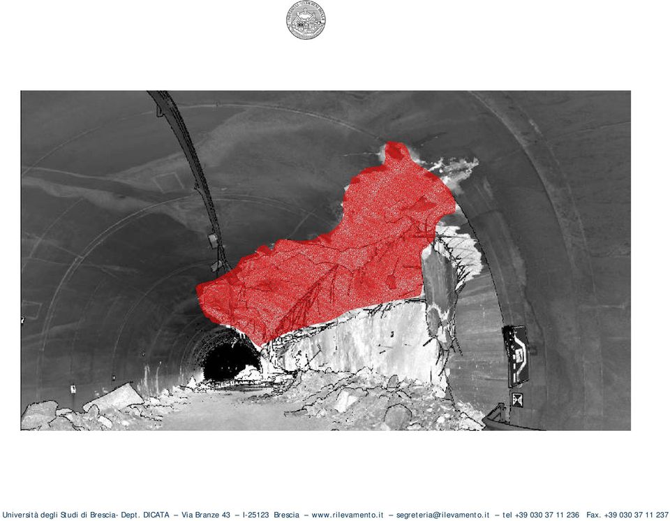
3 CASE STUDY ROAD TUNNEL: - 10 meters inside diameter - Structural collapsing of concrete coating and overhanging rock mass detachment in the roadside rest area

4
5 DEMAND ANALYSIS ACQUIRED DATA FEATURE EXTRACTION PURPOSES DEMAND COMPLETE GEOMETRY EXTRACT MORPHOLOGICAL INFORMATION GRAPHICS REPRESENTATION 3D MODEL PLANS SECTIONS REFLACTANCE VALUES DIGITAL IMAGES LOCALIZE INTERESTING ZONES POSITIONING DIFFERENT MATERIALS CONSTR. PARTICULAR RED FAULT - STEEL BARS POSITION

6 - Instruments choice LASER SCANNER For this kind of application a phase shift laser scanner, with a fast rate of point acquisition combined by a good accuracy and resolution is suggested. In this application the characteristics of the hardware are as follow: Phase shift laser scanner - Range: 53 m - Field of view: 360 x 310 degrees - Speed: up to 500,000 pts/sec - Resolution: 350 micro-radians min. angular step

7 - Instruments choice TOTAL STATION As total station, to measure the target point, we suggest an instruments with a RL (reflector less) distanziometer. The total station must have at least an accuracy of 1,5 mgon in angle and 2+2 ppm in distance accuracy.

8 - Software choice SOFTWARE - Laser control To manage the laser scanner data the software Reconstructor developed by the JRC (Joint Research Centre of the European Commission) has been used - Pre-processing - Registration - Meshing/Integration -Texture/Texture Mapping - Inspection - File view

9 On field operations planning COLLAPSED ZONE PLANNING THE SCAN POSITIONS ON A NOT COLLAPSED ZONE 38 m

10 On field operations planning PLANNING THE SCAN POSITIONS ON A NOT COLLAPSED ZONE UNDAMAGED ZONE 38 m 1 2

11 Laser Measuring session CHARACTERISTICS OF ACQUIRED CLOUDS OF POINTS POINT CLOUD RESOLUTION: The obtained point clouds have around 7mm points spacing Small Elements are observable and can be measured 7mm at 6 m

12 Georeferencing the scans GEOREFERENCING THE ACQUIRED POINT CLOUDS The clouds of points are placed in a local or cartographic reference system The best fitting of the different scans is optimized thanks to the ICP (automatic registration)

13 Data processing 3D JRC Reconstructor DATA PROCESSING WITH RECONSTRUCTOR 1/2 Besides their georeferencing and mutual registration, the point clouds of the scans have been processed according to the following operations: 1. Normal computation: the local surface normal is computed 2. Confidence computation: calculate the reliability for each single measured point. 3. Edge detection: angular and distance discontinuity have been computed and represented with edges. 4. Noise reduction: this operation has been needful to reduce the presence of noise in the scan range using filters.

14 Data processing 3D JRC Reconstructor DATA PROCESSING WITH RECONSTRUCTOR 2/2 5. Data clustering: the creation of a hierarchical structures has been performed. 6. Integration: during this phase the processing software has to remove the redundancy introduced through overlapping scans. 7. Meshing: this process has finally converted the set of raw 3D points into a continuous surface. 8. Texture Processing: the integration of the 3D measurements from the laser scanner with 2D information taken with an external camera has been carried out.

15 Extraction of geometrical information EXTRACTION OF GEOMETRICAL INFORMATION Realisation of cross-sections a) In this case study the extraction of the DWG files has been carried on by the surveyor. b) The University of Brescia has also tested its own developed software 3D Manager. The research is going in the way to permit to the final user, not to expert in 3D laser scanning data, to extract by himself the information from the 3D model. In this way the 3D model can be really used not only by the laser scanner expert but also by civil engineers, geologists, architects, that means by what can be called the final user of the survey.

16 Extraction of geometrical information EXTRACTION OF GEOMETRICAL INFORMATION Realisation of cross-sections Sectioning planes are defined by their geometrical position specifying n : the normal unit vector. n

17 Extraction of geometrical information EXTRACTION OF GEOMETRICAL INFORMATION Realisation of the plans

18 Extraction of geometrical information EXTRACTION OF GEOMETRICAL INFORMATION Positioning the main steel bars and the red fault Steel bars position (x,y,z) Red fault contour
 Red")
19 CONCLUSIONS immediate structures restoring acquisition of all the considerable geometric features Possibility to survey and represent quickly complex geometry situations: provides to associate the geometry to the visual information precise surveying of the main geological and structural units can be conveniently adopted in road and rail tunnels in order to minimize the influence on the regular traffic

20 University of Brescia Department DICATA Sede legale: Unviersity of Brescia Deparment DICATA Via Branze 43 I Brescia - segreteria@rilevamento.it tel/fax From Monday to Friday P.M. More information and didactic presentation in

Software solutions for Lynxs, Ilris and ALTM sensors data fusion Matteo Sgrenzaroli, Eng Phd, - Marco Fiocco Eng Giorgio Vassena, Prof.
 Software solutions for Lynxs, Ilris and ALTM sensors data fusion Matteo Sgrenzaroli, Eng Phd, - Marco Fiocco Eng Giorgio Vassena, Prof. Eng Who we are Gexcel stands for Geomatics & Excellence is a spin
RIEGL VZ-400 NEW. Laser Scanners. Latest News March 2009
 Latest News March 2009 NEW RIEGL VZ-400 Laser Scanners The following document details some of the excellent results acquired with the new RIEGL VZ-400 scanners, including: Time-optimised fine-scans The
technical notes trimble realworks software
 technical notes trimble realworks software A POWERFUL 3D LASER SCANNING OFFICE SOFTWARE SUITE Designed for today s multifaceted scanning professional, Trimble RealWorks is a powerful office software that
The process components and related data characteristics addressed in this document are:
 TM Tech Notes Certainty 3D November 1, 2012 To: General Release From: Ted Knaak Certainty 3D, LLC Re: Structural Wall Monitoring (#1017) rev: A Introduction TopoDOT offers several tools designed specifically
Trimble Realworks Software
 TECHNICAL NOTES Trimble Realworks Software A Powerful 3D Laser Scanning Office Software Suite DESIGNED FOR TODAY S MULTIFACETED SCANNING PROFESSIONAL, TRIMBLE REALWORKS IS A POWERFUL OFFICE SOFTWARE THAT
3D Laser Scanning Technology. Rugged hardware and powerful software combined with streamlined survey workflow
 3D Laser Scanning Technology Rugged hardware and powerful software combined with streamlined survey workflow Maptek specialises in the research, development and application of 3D laser scanning technology.
Determining the Roughness Angles of Surfaces Using Laser Scanners
 , TURKEY Keywords: Laser Scanner, 3D Model, DEM, Geology, Surface Roughness SUMMARY Terrestrial laser scanners are measuring instruments providing the detailed 3D object geometry directly and fastly. The
HIGH-PERFORMANCE INSPECTION VEHICLE FOR RAILWAYS AND TUNNEL LININGS. HIGH-PERFORMANCE INSPECTION VEHICLE FOR RAILWAY AND ROAD TUNNEL LININGS.
 HIGH-PERFORMANCE INSPECTION VEHICLE FOR RAILWAYS AND TUNNEL LININGS. HIGH-PERFORMANCE INSPECTION VEHICLE FOR RAILWAY AND ROAD TUNNEL LININGS. The vehicle developed by Euroconsult and Pavemetrics and described
IP-S2 Compact+ 3D Mobile Mapping System
 IP-S2 Compact+ 3D Mobile Mapping System 3D scanning of road and roadside features Delivers high density point clouds and 360 spherical imagery High accuracy IMU options without export control Simple Map,
Description of field acquisition of LIDAR point clouds and photos. CyberMapping Lab UT-Dallas
 Description of field acquisition of LIDAR point clouds and photos CyberMapping Lab UT-Dallas Description of field acquisition of LIDAR point clouds and photos Objective: Introduce the basic steps that
ASSESSMENT OF VISUALIZATION SOFTWARE FOR SUPPORT OF CONSTRUCTION SITE INSPECTION TASKS USING DATA COLLECTED FROM REALITY CAPTURE TECHNOLOGIES
 ASSESSMENT OF VISUALIZATION SOFTWARE FOR SUPPORT OF CONSTRUCTION SITE INSPECTION TASKS USING DATA COLLECTED FROM REALITY CAPTURE TECHNOLOGIES ABSTRACT Chris Gordon 1, Burcu Akinci 2, Frank Boukamp 3, and
Distributors Meeting Singapore 2015
 Gexcel is located in Italy inside technology parks, in the Sardinia island and in Brescia. More then 20% of the annual budget of Gexcel is spent in Research & Development activities. Distributors Meeting
3D MODELING OF LARGE AND COMPLEX SITE USING MULTI-SENSOR INTEGRATION AND MULTI-RESOLUTION DATA
 3D MODELING OF LARGE AND COMPLEX SITE USING MULTI-SENSOR INTEGRATION AND MULTI-RESOLUTION DATA G. Guidi 1, F. Remondino 2, 3, M. Russo 1, F. Menna 4, A. Rizzi 3 1 Dept.INDACO, Politecnico of Milano, Italy
Point cloud processing - scanning, analysing and validating
 Point cloud processing - scanning, analysing and validating NPL Freeform Centre of Excellence launch -1 st October Andy Robinson Contents Heat shield tile measurements Laser scanner performance analysis
Drawing Accurate Ground Plans from Laser Scan Data
 Drawing Accurate Ground Plans from Laser Scan Data Kevin Cain Institute for the Study and Integration of Graphical Heritage Techniques (INSIGHT) Abstract. In addition to the kinds of standard documentation
IP-S3 HD1. Compact, High-Density 3D Mobile Mapping System
 IP-S3 HD1 Compact, High-Density 3D Mobile Mapping System Integrated, turnkey solution Ultra-compact design Multiple lasers minimize scanning shades Unparalleled ease-of-use No user calibration required
MODERN VOXEL BASED DATA AND GEOMETRY ANALYSIS SOFTWARE TOOLS FOR INDUSTRIAL CT
 MODERN VOXEL BASED DATA AND GEOMETRY ANALYSIS SOFTWARE TOOLS FOR INDUSTRIAL CT C. Reinhart, C. Poliwoda, T. Guenther, W. Roemer, S. Maass, C. Gosch all Volume Graphics GmbH, Heidelberg, Germany Abstract:
DELPH v3.0. seabed mapping software suite
 DELPH v3.0 seabed mapping software suite DELPH seabed mapping software suite DELPH SEISMIC, DELPH SONAR and DELPH MAG are complete software packages with dedicated acquisition, processing and interpretation
I-SiTE - Laser Scanning Revolutionises Site Survey
 I-SiTE - Laser Scanning Revolutionises Site Survey I.K. Kapageridis Maptek/KRJA Systems Ltd, United Kingdom ABSTRACT: MAPTEK's revolutionary I-SiTE 3D Laser Imaging System, presented in this paper, is
3D Scanner using Line Laser. 1. Introduction. 2. Theory
 . Introduction 3D Scanner using Line Laser Di Lu Electrical, Computer, and Systems Engineering Rensselaer Polytechnic Institute The goal of 3D reconstruction is to recover the 3D properties of a geometric
IP-S2 HD. High Definition 3D Mobile Mapping System
 IP-S2 HD High Definition 3D Mobile Mapping System Integrated, turnkey solution High Density, Long Range LiDAR sensor for ultimate in visual detail High Accuracy IMU and DMI Odometry for positional accuracy
LASER SCANNER APPLICATION ON COMPLEX SHAPES OF ARCHITECTURE. PROFILES EXTRACTION PROCESSING AND 3D MODELLING.
 LASER SCANNER APPLICATION ON COMPLEX SHAPES OF ARCHITECTURE. PROFILES EXTRACTION PROCESSING AND 3D MODELLING. Carlo MONTI Full Professor E-mail: carlo.monti@polimi.it Luigi FREGONESE Research Assegnist
How To Fuse A Point Cloud With A Laser And Image Data From A Pointcloud
 REAL TIME 3D FUSION OF IMAGERY AND MOBILE LIDAR Paul Mrstik, Vice President Technology Kresimir Kusevic, R&D Engineer Terrapoint Inc. 140-1 Antares Dr. Ottawa, Ontario K2E 8C4 Canada paul.mrstik@terrapoint.com
Using Optech LMS to Calibrate Survey Data Without Ground Control Points
 Challenge An Optech client conducted an airborne lidar survey over a sparsely developed river valley. The data processors were finding that the data acquired in this survey was particularly difficult to
Detection of water leakage using laser images from 3D laser scanning data
 Detection of water leakage using laser images from 3D laser scanning data QUANHONG FENG 1, GUOJUAN WANG 2 & KENNERT RÖSHOFF 3 1 Berg Bygg Konsult (BBK) AB,Ankdammsgatan 20, SE-171 43, Solna, Sweden (e-mail:feng@bergbyggkonsult.se)
Efficient Storage, Compression and Transmission
 Efficient Storage, Compression and Transmission of Complex 3D Models context & problem definition general framework & classification our new algorithm applications for digital documents Mesh Decimation
Optical Digitizing by ATOS for Press Parts and Tools
 Optical Digitizing by ATOS for Press Parts and Tools Konstantin Galanulis, Carsten Reich, Jan Thesing, Detlef Winter GOM Gesellschaft für Optische Messtechnik mbh, Mittelweg 7, 38106 Braunschweig, Germany
LANDSLIDE MONITORING IN THE CONTEXT OF SUSTAINABLE DEVELOPMENT
 LANDSLIDE MONITORING IN THE CONTEXT OF SUSTAINABLE DEVELOPMENT S.I. HERBAN1, Clara-Beatrice VÎLCEANU2 1,2 Politehnica University of Timişoara, Faculty of Civil Engineering, Department of Land Measurements
Laser Scanning Surveying and Ground Penetrating Radar The Full Three Dimensional Picture Above and Below Ground
 Laser Scanning Surveying and Ground Penetrating Radar The Full Three Dimensional Picture Above and Below Ground CIVILEX 2009 Mark Hudson, Director, Coastway, FInstCES MRICS MIS BTS Jeff Hott, Laser Scanning
ENGN 2502 3D Photography / Winter 2012 / SYLLABUS http://mesh.brown.edu/3dp/
 ENGN 2502 3D Photography / Winter 2012 / SYLLABUS http://mesh.brown.edu/3dp/ Description of the proposed course Over the last decade digital photography has entered the mainstream with inexpensive, miniaturized
3D MODELLING OF GEOLOGICAL STRUCTURES FOR UNDERGROUND CAVERNS : A NEW AND SIMPLE METHODOLOGY
 N 250 3D MODELLING OF GEOLOGICAL STRUCTURES FOR UNDERGROUND CAVERNS : A NEW AND SIMPLE METHODOLOGY P. VASKOU (Géostock) J. MORRUZZI (Géostock) 6 th ARMS (Asian Rock Mechanic Symposium) 23-27 October 2010
A Simple Guide To Understanding 3D Scanning Technologies
 A Simple Guide To Understanding 3D Scanning Technologies First Edition www.lmi3d.com Table of Contents Introduction At LMI Technologies, solving complex problems in a simple way is the philosophy that
Leeds the Automation Degree in the Processing of Laser Scan Data to Better Final Products?
 Leeds the Automation Degree in the Processing of Laser Scan Data to Better Final Products? Ivo MILEV, Germany Key words: Terrestrial Laser scanning for engineering survey, site surveying, data processing
Types of 3D Scanners and 3D Scanning Technologies.
 Types of 3D Scanners and 3D Scanning Technologies. There are many types of 3D scanners and 3D scanning technologies. Some are ideal for short range scanning while others are better suited for mid or long
Laser Scanning. Efficient solutions for complex challenges
 Laser Scanning Efficient solutions for complex challenges 3D scatter plot DMT laser scanning the faster and more cost-effective way to reach your goals In many areas of industrial surveying laser scanning
High speed 3D capture for Configuration Management DOE SBIR Phase II Paul Banks Paul.banks@tetravue.com
 High speed 3D capture for Configuration Management DOE SBIR Phase II Paul Banks Paul.banks@tetravue.com Advanced Methods for Manufacturing Workshop September 29, 2015 1 TetraVue does high resolution 3D
Photogrammetry and 3D Car Navigation
 Strassenburg-Kleciak 309 Photogrammetry and 3D Car Navigation MAREK STRASSENBURG-KLECIAK, Hamburg ABSTRACT The technological development of recent hardware systems of car navigation systems allows the
GEOENGINE MSc in Geomatics Engineering (Master Thesis) Anamelechi, Falasy Ebere
 Anamelechi, Falasy Ebere") Master s Thesis: ANAMELECHI, FALASY EBERE Analysis of a Raster DEM Creation for a Farm Management Information System based on GNSS and Total Station Coordinates Duration of the Thesis: 6 Months Completion
Master s Thesis: ANAMELECHI, FALASY EBERE Analysis of a Raster DEM Creation for a Farm Management Information System based on GNSS and Total Station Coordinates Duration of the Thesis: 6 Months Completion
3D Laser Scanner. Extra long range laser scanner combined with a high resolution digital panoramic camera
 3D Laser Scanner Fast, PORTABLE, accurate Extra long range laser scanner combined with a high resolution digital panoramic camera INTRODUCING THE MAPTEK I-SITE 8800 LASER SCANNER > From Pit to Mine Model
Arm2. Arm Arm22. Articulated Arm. machines MEASURING. tridimensional measuring FRATELLI ROTONDI
 Arm Arm22 2 Arm2 tridimensional measuring Articulated Arm MEASURING machines FRATELLI ROTONDI Arm2 MEASURING Arm2Arm2 SOFTWARE Software in WINDOWS environment: sura tridimesio - elements with definite
DOCUMENTATION AND VISUALIZATION OF AN AS-BUILT TUNNEL BY COMBINING 3D LASER SCANNING AND WEB MAPPING
 DOCUMENTATION AND VISUALIZATION OF AN AS-BUILT TUNNEL BY COMBINING 3D LASER SCANNING AND WEB MAPPING Chengyi Zhang a, *, David Arditi b, Zhong Chen c a Graduate student, Dept. of Civil, Architectural,
A. OPENING POINT CLOUDS. (Notepad++ Text editor) (Cloud Compare Point cloud and mesh editor) (MeshLab Point cloud and mesh editor)
 (Cloud Compare Point cloud and mesh editor) (MeshLab Point cloud and mesh editor)") MeshLAB tutorial 1 A. OPENING POINT CLOUDS (Notepad++ Text editor) (Cloud Compare Point cloud and mesh editor) (MeshLab Point cloud and mesh editor) 2 OPENING POINT CLOUDS IN NOTEPAD ++ Let us understand
MeshLAB tutorial 1 A. OPENING POINT CLOUDS (Notepad++ Text editor) (Cloud Compare Point cloud and mesh editor) (MeshLab Point cloud and mesh editor) 2 OPENING POINT CLOUDS IN NOTEPAD ++ Let us understand
3D BYZANTINEB 3D ARCHAEOA. 3D Crypts. 3D Sub Divo RCHAEO
 Electronic Imaging 2003 20/01/2003 Electronic Imaging 2003 Santa Clara, California Videometrics VII Wednesday 22 January Santa Clara, USA J-A Beraldin(1), Picard(1), El-Hakim(1), M. S.F. G. V. Valzano(2),
ACCURACY ASSESSMENT OF BUILDING POINT CLOUDS AUTOMATICALLY GENERATED FROM IPHONE IMAGES
 ACCURACY ASSESSMENT OF BUILDING POINT CLOUDS AUTOMATICALLY GENERATED FROM IPHONE IMAGES B. Sirmacek, R. Lindenbergh Delft University of Technology, Department of Geoscience and Remote Sensing, Stevinweg
VERSATILE AND EASY-TO-USE 3D LASER SCANNERS > >
 VERSATILE AND EASY-TO-USE 3D LASER SCANNERS > > A WORLD OF APPLICATIONS 3D Systems, producers of the industry s fastest, easiest-to-use and most versatile 3D scanners, makes 3D scanning ideal for a wide
Manufacturing Process and Cost Estimation through Process Detection by Applying Image Processing Technique
 Manufacturing Process and Cost Estimation through Process Detection by Applying Image Processing Technique Chalakorn Chitsaart, Suchada Rianmora, Noppawat Vongpiyasatit Abstract In order to reduce the
Digital Remote Sensing Data Processing Digital Remote Sensing Data Processing and Analysis: An Introduction and Analysis: An Introduction
 Digital Remote Sensing Data Processing Digital Remote Sensing Data Processing and Analysis: An Introduction and Analysis: An Introduction Content Remote sensing data Spatial, spectral, radiometric and
A PHOTOGRAMMETRIC APPRAOCH FOR AUTOMATIC TRAFFIC ASSESSMENT USING CONVENTIONAL CCTV CAMERA
 A PHOTOGRAMMETRIC APPRAOCH FOR AUTOMATIC TRAFFIC ASSESSMENT USING CONVENTIONAL CCTV CAMERA N. Zarrinpanjeh a, F. Dadrassjavan b, H. Fattahi c * a Islamic Azad University of Qazvin - nzarrin@qiau.ac.ir
Synthetic Sensing: Proximity / Distance Sensors
 Synthetic Sensing: Proximity / Distance Sensors MediaRobotics Lab, February 2010 Proximity detection is dependent on the object of interest. One size does not fit all For non-contact distance measurement,
3D SCANNING: A NEW APPROACH TOWARDS MODEL DEVELOPMENT IN ADVANCED MANUFACTURING SYSTEM
 3D SCANNING: A NEW APPROACH TOWARDS MODEL DEVELOPMENT IN ADVANCED MANUFACTURING SYSTEM Dr. Trikal Shivshankar 1, Patil Chinmay 2, Patokar Pradeep 3 Professor, Mechanical Engineering Department, SSGM Engineering
ZEISS T-SCAN Automated / COMET Automated 3D Digitizing - Laserscanning / Fringe Projection Automated solutions for efficient 3D data capture
 ZEISS T-SCAN Automated / COMET Automated 3D Digitizing - Laserscanning / Fringe Projection Automated solutions for efficient 3D data capture ZEISS 3D Digitizing Automated solutions for efficient 3D data
Quality management of 3D cultural heritage replicas with CIDOC-CRM
 Quality management of 3D cultural heritage replicas with CIDOC-CRM Nicola Amico 1, Paola Ronzino 1, Achille Felicetti 1, Franco Niccolucci 2 1 PIN, VAST-LAB, Prato, Italy {nicola.amico, paola.ronzino,
Petra documentation project using Laser Scanning
 Petra documentation project using Laser Scanning The Zamani research group in the Geomatics Division at the University of Cape Town has completed the third phase of the documentation of the UNESCO World
Characterization of Three Algorithms for Detecting Surface Flatness Defects from Dense Point Clouds
 Characterization of Three Algorithms for Detecting Surface Flatness Defects from Dense Point Clouds Pingbo Tang, Dept. of Civil and Environ. Eng., Carnegie Mellon Univ. Pittsburgh, PA 15213, USA, Tel:
Kwan Lam CHOW, HKSAR, China
 Engineering Survey Applications of Terrestrial Laser Scanner in Highways Department of the Government of Kwan Lam CHOW, HKSAR, China Key words: Terrestrial Laser Scanner SUMMARY This paper describes about
Title: The leading fusion of Laser scanning and Close range Photogrammetry Subtitle: Laser-Photogrammetric mapping of Bam Citadel (Arg-E-Bam)
") Title: The leading fusion of Laser scanning and Close range Photogrammetry Subtitle: Laser-Photogrammetric mapping of Bam Citadel (Arg-E-Bam) Abstract In the last days of the year 2003 a terrible earth
Title: The leading fusion of Laser scanning and Close range Photogrammetry Subtitle: Laser-Photogrammetric mapping of Bam Citadel (Arg-E-Bam) Abstract In the last days of the year 2003 a terrible earth
3D Building Roof Extraction From LiDAR Data
 3D Building Roof Extraction From LiDAR Data Amit A. Kokje Susan Jones NSG- NZ Outline LiDAR: Basics LiDAR Feature Extraction (Features and Limitations) LiDAR Roof extraction (Workflow, parameters, results)
ELEMENTS OF SOFTWARE INTEGRATION OF PRODUCTION SYSTEMS IN INDUSTRIAL PRODUCT CONTROL AND DIDACTICS 1. INTRODUCTION
 Journal of Machine Engineering, Vol. 13, No. 4, 2013 part inspection, coordinate instruments, optical scanner Halina NIECIĄG 1 Piotr DUDEK 1 ELEMENTS OF SOFTWARE INTEGRATION OF PRODUCTION SYSTEMS IN INDUSTRIAL
University Rd., Tainan, Taiwan, R.O.C., hsiao_na@hotmail.com
 THE DIGITAL RECONSTRUCTION OF A LARGE-SCALE CONSTRUCTION SIMULATED BY USING 3D LASER SCANNING TECHNOLOGY A BRICK KILN S CHIMNEY IN KAOHSIUNG CITY OF TAIWAN AS AN EXAMPLE Yi-Chun LIN 1, Tsung-Chiang WU
HIGH AND LOW RESOLUTION TEXTURED MODELS OF COMPLEX ARCHITECTURAL SURFACES
 HIGH AND LOW RESOLUTION TEXTURED MODELS OF COMPLEX ARCHITECTURAL SURFACES E. K. Stathopoulou a, A. Valanis a, J. L. Lerma b, A. Georgopoulos a a Laboratory of Photogrammetry, National Technical University
Digital Terrain Model Grid Width 10 m DGM10
 Digital Terrain Model Grid Width 10 m Status of documentation: 23.02.2015 Seite 1 Contents page 1 Overview of dataset 3 2 Description of the dataset contents 4 3 Data volume 4 4 Description of the data
Automotive Applications of 3D Laser Scanning Introduction
 Automotive Applications of 3D Laser Scanning Kyle Johnston, Ph.D., Metron Systems, Inc. 34935 SE Douglas Street, Suite 110, Snoqualmie, WA 98065 425-396-5577, www.metronsys.com 2002 Metron Systems, Inc
Model Repair. Leif Kobbelt RWTH Aachen University )NPUT $ATA 2EMOVAL OF TOPOLOGICAL AND GEOMETRICAL ERRORS !NALYSIS OF SURFACE QUALITY
NPUT $ATA 2EMOVAL OF TOPOLOGICAL AND GEOMETRICAL ERRORS !NALYSIS OF SURFACE QUALITY") )NPUT $ATA 2ANGE 3CAN #!$ 4OMOGRAPHY 2EMOVAL OF TOPOLOGICAL AND GEOMETRICAL ERRORS!NALYSIS OF SURFACE QUALITY 3URFACE SMOOTHING FOR NOISE REMOVAL 0ARAMETERIZATION 3IMPLIFICATION FOR COMPLEXITY REDUCTION
)NPUT $ATA 2ANGE 3CAN #!$ 4OMOGRAPHY 2EMOVAL OF TOPOLOGICAL AND GEOMETRICAL ERRORS!NALYSIS OF SURFACE QUALITY 3URFACE SMOOTHING FOR NOISE REMOVAL 0ARAMETERIZATION 3IMPLIFICATION FOR COMPLEXITY REDUCTION
CASE STUDY LANDSLIDE MONITORING
 Introduction Monitoring of terrain movements (unstable slopes, landslides, glaciers, ) is an increasingly important task for today s geotechnical people asked to prevent or forecast natural disaster that
VERSATILE AND EASY-TO-USE 3D LASER SCANNERS > >
 VERSATILE AND EASY-TO-USE 3D LASER SCANNERS > > A WORLD OF APPLICATIONS Z Corporation, producers of the industry s fastest, easiest-to-use and most versatile 3D scanners, makes 3D scanning ideal for a
In Flight ALS Point Cloud Georeferencing using RTK GPS Receiver
 Integration of Geodetic Sensors In Flight ALS Point Cloud Georeferencing using RTK GPS Receiver Yannick Stebler, Philipp Schär, Jan Skaloud, Bertrand Merminod E mail: yannick.stebler@epfl.ch Web: http://topo.epfl.ch
INTERNATIONAL SYMPOSIUM ON. Bali, Indonesia, June 1 ST 6 TH, 2014
 Abstract Number : 446 INTERNATIONAL SYMPOSIUM ON Bali, Indonesia, June 1 ST 6 TH, 2014 MODERN TOOLS FOR THE MONITORING OF DAMS hhdttjjhkljdjjsgshjhfsdkjhskslsl;s;s;;s;;s;;sjsjkjffffrtttttttfggjfgjgkfkjkjf
Land Mobile Mapping & Survey
 Land Mobile Mapping & Survey Trimble Geospatial Solutions Trimble s geospatial solution portfolio has been designed to put information to work. Mobile sensors on the land, in the air or indoors capture
VENETOREGION ROAD NETWORK ROAD MAPPING LASER SCANNING FACILITY MANAGEMENT
 VENETOREGION ROAD NETWORK ROAD MAPPING LASER SCANNING FACILITY MANAGEMENT ing. Augusto Burchi burchi@sitecoinf.it Siteco profile Italian software house specialized in GIS and RDBMS dedicated to Road networks
CAD / CAM Dr. P. V. Madhusuthan Rao Department of Mechanical Engineering Indian Institute of Technology, Delhi Lecture No. # 12 Reverse Engineering
 CAD / CAM Dr. P. V. Madhusuthan Rao Department of Mechanical Engineering Indian Institute of Technology, Delhi Lecture No. # 12 Reverse Engineering So what we will do in today s lecture is basically take
Fast, Reliable, Highly Precise: Image processing system for beverage and food industry
 ISRA Vision Group, the market leader in many areas of industrial image processing, presents a new turn-key inspection system that provides 100% inline quality control of metal packages for the beverage
Creation of an Unlimited Database of Virtual Bone. Validation and Exploitation for Orthopedic Devices
 Creation of an Unlimited Database of Virtual Bone Population using Mesh Morphing: Validation and Exploitation for Orthopedic Devices Najah Hraiech 1, Christelle Boichon 1, Michel Rochette 1, 2 Thierry
GOM Optical Measuring Techniques. Deformation Systems and Applications
 GOM Optical Measuring Techniques Deformation Systems and Applications ARGUS Forming Analysis ARGUS Deformation analysis in sheet metal and forming industry Forming Characteristics of Sheet Metals Material
Multiphysics Software Applications in Reverse Engineering
 Multiphysics Software Applications in Reverse Engineering *W. Wang 1, K. Genc 2 1 University of Massachusetts Lowell, Lowell, MA, USA 2 Simpleware, Exeter, United Kingdom *Corresponding author: University
Digital Documentation of Cultural Heritage Objects using hybrid recording techniques
 The 7th International Symposium on Virtual Reality, Archaeology and Cultural Heritage VAST (2006) M. Ioannides, D. Arnold, F. Niccolucci, K. Mania (Editors) Project Papers Digital Documentation of Cultural
3D SCANNING SOLUTION FOR PIPELINE INTEGRIT Y ASSESSMENT!
 NDT SOLUTIONS 3D SCANNING SOLUTION FOR PIPELINE INTEGRIT Y ASSESSMENT! CODE-COMPLIANT Pipeline operators and NDT service companies must deal with increasing pressure from regulation authorities and environmentalists
Teaching and Learning Strategies for 3D Urban and Landscape Modelling
 Teaching and Learning Strategies for 3D Urban and Landscape Modelling Martin SMITH, Andrew BURTON, and Nikolaos KOKKAS, United Kingdom Key words: 3D modelling, visualization, teaching, learning SUMMARY
Innovative capture and modeling of existing building conditions using 3D laser scanning. Entry B Submission
 Innovative capture and modeling of existing building conditions using 3D laser scanning Entry B Submission Executive Summary As a large owner organization, understanding and developing new technologies
A System for Capturing High Resolution Images
 A System for Capturing High Resolution Images G.Voyatzis, G.Angelopoulos, A.Bors and I.Pitas Department of Informatics University of Thessaloniki BOX 451, 54006 Thessaloniki GREECE e-mail: pitas@zeus.csd.auth.gr
A HYBRID GROUND DATA MODEL TO SUPPORT INTERACTION IN MECHANIZED TUNNELING
 A HYBRID GROUND DATA MODEL TO SUPPORT INTERACTION IN MECHANIZED TUNNELING F. HEGEMANN P. MANICKAM K. LEHNER M. KÖNIG D. HARTMANN Department of Civil and Environmental Engineering, Ruhr-University of Bochum,44780
AutoCAD i 3D Samordningsmodell Tips og Triks for tegning i 3D med AutoCAD
 AutoCAD i 3D Samordningsmodell Tips og Triks for tegning i 3D med AutoCAD Tesfaye Kebede Vianova systems AutoCAD 3D AutoCAD - 3D Samordningsmodell - Course Contents - New Features 3D AutoCAD 2013 - Sheet
Differentiation of 3D scanners and their positioning method when applied to pipeline integrity
 11th European Conference on Non-Destructive Testing (ECNDT 2014), October 6-10, 2014, Prague, Czech Republic More Info at Open Access Database www.ndt.net/?id=16317 Differentiation of 3D scanners and their
Application Example: Quality Control. Turbines: 3D Measurement of Water Turbines
 Application Example: Quality Control Turbines: 3D Measurement of Water Turbines Measuring Systems: ATOS, TRITOP Keywords: Kaplan, Francis, Pelton, angles 3D scanning of turbines was performed successfully
Application Report. Propeller Blade Inspection Station
 34935 SE Douglas Street, Suite, Snoqualmie, WA 9874 Ph: 425-396-5577 Fax: 425-396-586 Application Report Propeller Blade Inspection Station Prepared By Kyle Johnston, Ph. D. Metron Systems Inc.5.5 3 2.5
Collision Prevention and Area Monitoring with the LMS Laser Measurement System
 Collision Prevention and Area Monitoring with the LMS Laser Measurement System PDF processed with CutePDF evaluation edition www.cutepdf.com A v o i d...... collisions SICK Laser Measurement Systems are
Multi-Resolution Digital 3D Imaging & Modelling applied to the Documentation of rock art sites: Grotta dei Cervi in Italy
 Multi-Resolution Digital 3D Imaging & Modelling applied to the Documentation of rock art sites: Grotta dei Cervi in Italy J.-A. Beraldin 1, V. Valzano 2, A. Bandiera 2 1 IIT, National Research Council
Palmprint Recognition. By Sree Rama Murthy kora Praveen Verma Yashwant Kashyap
 Palmprint Recognition By Sree Rama Murthy kora Praveen Verma Yashwant Kashyap Palm print Palm Patterns are utilized in many applications: 1. To correlate palm patterns with medical disorders, e.g. genetic
The X100. Safe and fully automatic. Fast and with survey accuracy. revolutionary mapping. create your own orthophotos and DSMs
 The X100 revolutionary mapping Safe and fully automatic create your own orthophotos and DSMs Fast and with survey accuracy operates even in harsh weather conditions (up to 65 km/h wind & light rain) Image
Pipeline External Corrosion Analysis Using a 3D Laser Scanner
 Pipeline Technology Conference 2013 Pipeline External Corrosion Analysis Using a 3D Laser Scanner Pierre-Hugues ALLARD, Charles MONY Creaform, www.creaform3d.com 5825 rue St-Georges, Lévis (QC), Canada,
Topographic Change Detection Using CloudCompare Version 1.0
 Topographic Change Detection Using CloudCompare Version 1.0 Emily Kleber, Arizona State University Edwin Nissen, Colorado School of Mines J Ramón Arrowsmith, Arizona State University Introduction CloudCompare
REGIONAL CENTRE FOR TRAINING IN AEROSPACE SURVEYS (RECTAS) MASTER IN GEOINFORMATION PRODUCTION AND MANAGEMENT
 MASTER IN GEOINFORMATION PRODUCTION AND MANAGEMENT") REGIONAL CENTRE FOR TRAINING IN AEROSPACE SURVEYS (RECTAS) MASTER IN GEOINFORMATION PRODUCTION AND MANAGEMENT PROGRAMME DESCRIPTION October 2014 1. The programme The academic programme shall be referred
REGIONAL CENTRE FOR TRAINING IN AEROSPACE SURVEYS (RECTAS) MASTER IN GEOINFORMATION PRODUCTION AND MANAGEMENT PROGRAMME DESCRIPTION October 2014 1. The programme The academic programme shall be referred
Alphacam Art combines Vectric s Aspire artistic design software with the market leading Alphacam manufacturing software.
 Alphacam Art Alphacam Art - CNC Routing For Artists & Ideal Jewellery Cad Cam Software Alphacam Art combines Vectric s Aspire artistic design software with the market leading Alphacam manufacturing software.
Surface Curvature from Laser Triangulation Data. John Rugis ELECTRICAL & COMPUTER ENGINEERING
 Surface Curvature from Laser Triangulation Data John Rugis ELECTRICAL & COMPUTER ENGINEERING 1) Laser scan data? Application: Digital archive, preserve, restore. Cultural and scientific heritage. Michelangelo
Tunnelling & Underground. Specialists
 Tunnelling & Underground Specialists Mined Tunnels Excavation at Ayer Rajah Avenue, Singapore Introduction Amberg & TTI Engineering Pte Ltd (AETTI) was established in Singapore in 2002 by Amberg Engineering
Automatic Wheel Profile Measuring Device for Tramway Vehicles
 Automatic Wheel Profile Measuring Device for Tramway Vehicles Technical description The automatic wheel profile measuring device is used to measure the wheel profile and diameter whilst a tramway vehicle
MetropoGIS: A City Modeling System DI Dr. Konrad KARNER, DI Andreas KLAUS, DI Joachim BAUER, DI Christopher ZACH
 MetropoGIS: A City Modeling System DI Dr. Konrad KARNER, DI Andreas KLAUS, DI Joachim BAUER, DI Christopher ZACH VRVis Research Center for Virtual Reality and Visualization, Virtual Habitat, Inffeldgasse
Processing the point cloud with RiscanPro or Riprofile. CyberMapping Lab UT-Dallas
 Processing the point cloud with RiscanPro or Riprofile CyberMapping Lab UT-Dallas RiScanPro Overview of how to import and display scans Table of Contents Window Start New Project Right Click SCANS New
XXI International CIPA Symposium, 01-06 October, Athens, Greece
 2 DIFFERENT TECHNIQUES OF SCANNING CULTURAL HERITAGE 1. CLOSE-RANGE-SCANNING OF 250 CLAYFIGURINES IN XIAN, CHINA 2. LASER-SCANNING OF 3.200 DINOSAUR-STEPS IN SUCRE, BOLIVIA Stefan Linsinger a Dipl.-Ing.
Modelling, Extraction and Description of Intrinsic Cues of High Resolution Satellite Images: Independent Component Analysis based approaches
 Modelling, Extraction and Description of Intrinsic Cues of High Resolution Satellite Images: Independent Component Analysis based approaches PhD Thesis by Payam Birjandi Director: Prof. Mihai Datcu Problematic