Matt Harris, Golder Associates (NZ) Ltd. The value of geophysics as a non-intrusive method for site characterisation
|
|
|
- Darcy Sharp
- 8 years ago
- Views:
Transcription
1 Matt Harris, Golder Associates (NZ) Ltd. The value of geophysics as a non-intrusive method for site characterisation

2 Presentation Outline What is geophysics and how can it help me? Electrical Resistivity Imaging (ERI) Landfill case study Electromagnetic (EM) surveying Landfill case studies Ground Penetrating Radar (GPR) Service detection case study Magnetic surveying Buried waste case study Considerations for geophysical surveying Conclusions Question Time

3 What is Geophysics and How Can It Help Me? Approach: Non-intrusive, remote-sensing Advantages: Complements intrusive investigation Covers large areas easily (fills in the gaps) Manages the risk in the selection of boreholes/test pits Fast way to identify localised impacts (drums, services, UST ) Limitation: Physical contrast (electrical, electromagnetic, magnetic, density or other properties) required between the target and host material
 Limitation: Physical contrast (electrical, electromagnetic,")
4 Introduction to Geophysical methods Electrical Resistivity Imaging (ERI) Electromagnetic (EM) surveying Ground Penetrating Radar (GPR) Magnetic surveying
 Magnetic")
5 Electrical Resistivity Imaging (ERI) THEORY ERI maps differences in the electrical properties of subsurface. Differences can result from variations in rock type, water content, water chemistry (i.e. leachate, salinity), buried material, or voids. APPLICATIONS Hydrogeological investigations Contaminant plumes Landfill investigations Geological mapping Depth to bedrock

6 Electrical Resistivity Imaging (ERI) EQUIPMENT Modern ERI systems consist of a switching unit connected to an array of electrodes emplaced in the ground. Powered by batteries or generator. Laptop used to download data Survey in 2D or 3D ACQUISITION RATE ~120 min / 100 m COST ~$ / 100 m


7 Sample 3D ERI Results

8 ERI Example Landfill #1 ERI used to provide supporting information for a hydrogeological model at boundary of landfill site Objective was to identify preferential pathways for leachate flow The results correlated with data from boreholes The results refined the interpolation between boreholes, contributing to the conceptual site model

9 ERI Example Landfill #1 Potential flowpaths Relatively impermeable Profile collected at 90 to presumed flowpath, adjacent to landfill

10 Electromagnetic (EM) Surveying THEORY Method is sensitive to changes in ground conductivity. Alternating current used to produce a time-varying magnetic field. This field in turn induces current to flow in the ground. The induced currents produce a secondary time-varying magnetic field, which is sensed by a receiver coil. No electrodes or ground contact necessary APPLICATIONS Metals, moisture, clays, dissolved ions Leachate if conditions allow (low noise)

11 Electromagnetic (EM) Surveying EQUIPMENT Several different approaches to EM surveying exist: EM31: 0-6 m depth. Quadrature (ground conductivity), in-phase (metal) responses EM34: up to 60 m depth. Groundwater, contaminant plumes EM61: 3-4 m depth. Buried metal (TEM) Large time domain loops (TDEM) can be used for hydrogeologic studies. ACQUISITION RATE ~ 5-10 min / 100 m COST ~$50 / 100 m (EM31)
 Large time domain loops (TDEM) can be used for hydrogeologic studies.")
12 Electromagnetic (EM) Surveying Equipment EQUIPMENT SHALLOW - EM31 (length = 4 m) DEEP - terratem INTERMEDIATE - EM34
 DEEP -")
13 EM/ERI Example - Landfill #2 Electromagnetic (EM31) and resistivity surveys carried out over historic waste site at former sand/gravel quarry Investigation to identify lateral and vertical extent of waste EM line spacing 3m (~6 m depth penetration) ERI electrode spacing 2 m (~30 m depth penetration) Three days of surveying on site
 ERI electrode spacing 2 m (~30 m depth penetration) Three days of")
14 Landfill #2 EM31 Quadrature Response


15 Landfill #2 EM31 Interpretation


16 Landfill #2 ERI Results (Line 3) Possible Boulder Clays/Till Moderately low and variable resistivity indicative of waste materials, thickness up to 5 m. Higher values likely represent C&D waste. Low resistivity clay zone interpreted to be original base of the quarried sand/gravel.

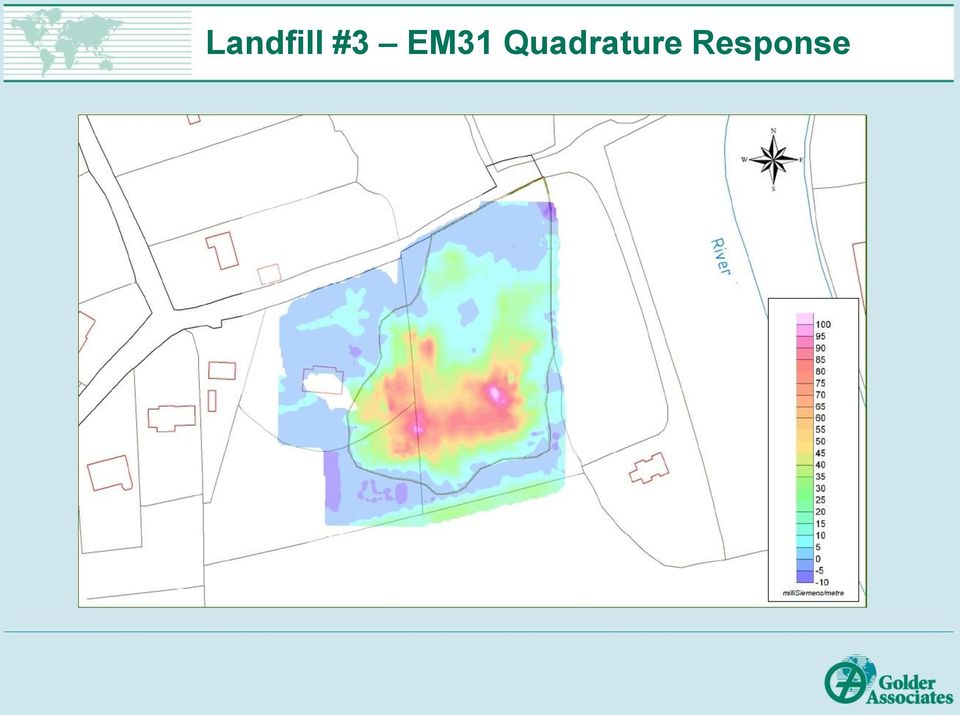
17 EM/ERI Example - Landfill #3 Electromagnetic (EM31) and resistivity surveys carried out over historic waste site at former rock quarry Investigation to identify lateral, vertical extents of waste. Used to guide intrusive investigations. EM line spacing 3 m, referenced by DGPS (~6 m depth penetration) ERI electrode spacing 2 m (~30 m depth penetration) Two days of surveying on site Resistivity effective at delineating vertical extents of waste, EM surveys useful for lateral extents.

18 Landfill #3 EM31 Quadrature Response

19 Landfill #3 EM31 Interpretation


20 Landfill #3 ERI Results (Line 3) Possible Boulder Clays/till Boulder clays (till) at 3 m to 7 m depth, indicated by higher resistivity Lower resistivity indicative of waste materials, thickness 5 m to 7 m ERI results correspond well with EM results

21 Ground Penetrating Radar (GPR) THEORY Use of radar pulses to image the subsurface (0-30 m depth) Sensitive to changes in the dielectric properties of the ground Typical frequencies employed are 25 MHz to 1000 MHz Frequency depends on desired depth penetration - Lower frequencies give greater penetration, but decreased resolution Depth penetration is influenced by ground conductivity highly conductive ground (clay, water) will reduce penetration significantly APPLICATIONS Effective at identifying buried utilities, also defining landfill boundaries (clay). If conditions allow, hydrocarbon plumes may be delineated Also archaeological and forensic investigations, shallow geology work
22 Ground Penetrating Radar (GPR) ACQUISITION RATE ~ 15 min / 100 m 400 MHz cart-mounted GPR antenna EQUIPMENT 200 MHz draggable GPR antenna with survey wheel COST ~$100 / 100 m
23 GPR Example Service Detection Large site that had seen a range of industrial land use activities for over a century Site featured multiple fuel storage areas and numerous service lines GPR was deployed as one component of comprehensive site investigation between two Golder teams Objective to identify potential sources and pathway for contaminant migration, develop site conceptual model

24 GPR Example Service Detection Survey
25 GPR Example Service Detection Results Diffractions off underground services GPR signal observed over underground storage tank (UST)
26 Magnetic Surveying THEORY Sensitive to magnetic minerals, iron bearing materials Total magnetic field or gradient may be measured Gradient more sensitive to small variations, removes need for base measurements Typical anomalies of single bodies are dipolar APPLICATIONS Can be effectively used to identify locations of buried iron/steel. e.g. buried drums, cars, etc. Also geological mapping, archaeology, mineral exploration
27 Magnetic Surveying EQUIPMENT Photo shows a magnetic gradiometry survey in progress Two sensors are mounted a fixed distance apart, to measure the vertical gradient of the magnetic field Standard magnetometry uses a single sensor ACQUISITION RATE ~ 5-15 min / 100 m COST ~$50 / 100 m
28 Magnetic/GPR Example - Buried Waste Investigation of a site that was suspected to contain illegally dumped waste in steel drums Essential that investigations carried out in non-intrusive manner Rapid survey required Magnetic gradiometry survey conducted, complemented by a 200 MHz GPR survey Surveys located using DGPS Results indicated one area worthy of further investigation
29 Magnetic/GPR Example - Buried Waste Magnetic Gradient GPR slice Dipolar anomaly Coincident GPR anomaly Steel fence
30 Considerations for Geophysical Surveying CONSIDERATIONS Anticipated physical contrast - dictates selection of appropriate geophysical technique Depth of target and geology Time and cost Sources of noise (e.g. power lines EM methods. Steel magnetometry) Site access - vegetation and topography can present problems Timing of survey best to carry out geophysics early in site investigation BENEFITS Extensive 2D or 3D data, as opposed to 1D data achieved by drilling Large, continuous areal coverage Non-intrusive, relatively discreet Speed of investigation
31 Conclusions Geophysics an be used to complement or to target intrusive investigations Aids in development of site conceptual model Wide range of techniques available Technique and survey parameters must be selected to suit site conditions, desired depth penetration and survey objectives
32 Question Time?
Moultrie Group Subsurface Geophysical Surveys
 Moultrie Group Subsurface Geophysical Surveys Martin Brook Moultrie Geology, Banyo, Brisbane, QLD 04 37887 362 mbrook@moultrie.com.au Subsurface Geophysical Surveys Martin Brook / Senior Project Geologist
Letter Report Geophysical Subsurface Investigation Activities and Results Suspected Burial Site, Corpus Christi, Texas W.O. No. 02444.019.005.
 Weston Solutions, Inc. 2705 Bee Cave Road, Suite 100 Austin, Texas 78746 512-651-7100 Fax 512-651-7101 www.westonsolutions.com Mr. Omar Valdez Project Manager Texas Commission on Environmental Quality
COBRA WiFi. 2 CHANNEL GPR Detect both shallow and deep pipes
 COBRA WiFi 2 CHANNEL GPR Detect both shallow and deep pipes WiFi operation no cables needed Dual Channel GPR, 250/500 MHz Complete GPR-system all inclusive Included Post Processing Software GPS Path Finder
hs2 Ground A non-technical guide
 hs2 Ground Investigations A non-technical guide Contents HS2 ground investigations 1 Essential Q&A 2 2 In-ground investigation techniques 9 2.1 Cable percussion borehole 10 2.2 Rotary core borehole 12
Groundwater Training Course SOPAC, April 2005. Electromagnetic (EM) Induction method for Groundwater Investigations
 Induction method for Groundwater Investigations") Groundwater Training Course SOPAC, April 2005 Electromagnetic (EM) Induction method for Groundwater Investigations Electromagnetic (EM) Induction Method Basic principle: An AC electric current is applied
Groundwater Training Course SOPAC, April 2005 Electromagnetic (EM) Induction method for Groundwater Investigations Electromagnetic (EM) Induction Method Basic principle: An AC electric current is applied
NuGeneration Ltd Site Investigations
 NuGeneration Ltd Site Investigations Introducing the site assessment and radiological characterisation project NuGen has commissioned an engineering consortium - which is a joint venture of IBERDROLA Ingeniería
This presentation reports on the progress made during the first year of the Mapping the Underworld project. As multiple Universities and Departments
 This presentation reports on the progress made during the first year of the Mapping the Underworld project. As multiple Universities and Departments are involved with the project, a single speaker will
Application of Geophysical Methods for Site Characterization
 State of Ohio Environmental Protection Agency Division of Drinking and Ground Waters Technical Guidance Manual for Ground Water Investigations Chapter 6 Application of Geophysical Methods for Site Characterization
Triad Issue Paper: Using Geophysical Tools to Develop the Conceptual Site Model December 2008
 Triad Issue Paper: Using Geophysical Tools to Develop the Conceptual Site Model December 2008 PURPOSE AND AUDIENCE This technology bulletin explains how hazardouswaste site professionals can use geophysical
Electromagnetic surveying
 Electromagnetic surveying Dr. Laurent Marescot laurent@tomoquest.com 1 Introduction Electrical surveying Resistivity method Induced polarization method (IP) Self-potential (SP) method Higher frequency
The successful integration of 3D seismic into the mining process: Practical examples from Bowen Basin underground coal mines
 Geophysics 165 Troy Peters The successful integration of 3D seismic into the mining process: Practical examples from Bowen Basin underground coal mines This paper discusses how mine staff from a number
APPENDIX I WORLEYPARSONS GPR REPORT (ISSUED IN ELECTRONIC FORM)
") Angela MacPherson, TCPL July 27, 2011 Northwest Mainline Loop, Timberwolf Section Geotechnical Assessment Report Project: 0098-101-01-06 APPENDIX I WORLEYPARSONS GPR REPORT (ISSUED IN ELECTRONIC FORM)
Angela MacPherson, TCPL July 27, 2011 Northwest Mainline Loop, Timberwolf Section Geotechnical Assessment Report Project: 0098-101-01-06 APPENDIX I WORLEYPARSONS GPR REPORT (ISSUED IN ELECTRONIC FORM)
Module 1 : Site Exploration and Geotechnical Investigation. Lecture 5 : Geophysical Exploration [ Section 5.1 : Methods of Geophysical Exploration ]
![Module 1 : Site Exploration and Geotechnical Investigation. Lecture 5 : Geophysical Exploration [ Section 5.1 : Methods of Geophysical Exploration ]](/thumbs/40/20679662.jpg "Module 1 : Site Exploration and Geotechnical Investigation. Lecture 5 : Geophysical Exploration [ Section 5.1 : Methods of Geophysical Exploration ]") Objectives In this section you will learn the following General Overview Different methods of geophysical explorations Electrical resistivity method Seismic refraction method 5 Geophysical exploration
Objectives In this section you will learn the following General Overview Different methods of geophysical explorations Electrical resistivity method Seismic refraction method 5 Geophysical exploration
GPR Antenna. Conduit. Also known as: Surface/Ground Probing Radar, Surface/Subsurface Penetrating Radar (SPR).
.") GPR Method N D E G R O U N D P E N E T R A T I N G R A D A R [ G P R] A PPLICATION The Ground Penetrating Radar (GPR) method is primarily applied to locate and measure the depth of steel reinforcement,
GPR Method N D E G R O U N D P E N E T R A T I N G R A D A R [ G P R] A PPLICATION The Ground Penetrating Radar (GPR) method is primarily applied to locate and measure the depth of steel reinforcement,
Groundwater exploration WATEX applications with Ground Penetrating Radars. Dr.Saud Amer USGS Dr.Alain Gachet Radar Technologies France
 Groundwater exploration WATEX applications with Ground Penetrating Radars Dr.Saud Amer USGS Dr.Alain Gachet Radar Technologies France GPR is a technology that allows rapid and non destructive collection
Ground Penetrating Radar Survey of a Portion of the Riverside Cemetery, Hopkinsville, Kentucky
 Ground Penetrating Radar Survey of a Portion of the Riverside Cemetery, Hopkinsville, Kentucky October 2012 Report prepared by Anthony L. Ortmann, Ph.D. Assistant Professor Department of Geosciences Murray
MONITORING THE GPR RESPONSE OF CURING CONCRETE T. De Souza 1, A.P. Annan 1, J.D. Redman 1, and N. Hu 1 1 Sensors & Software Inc., Mississauga, Canada
 MONITORING THE GPR RESPONSE OF CURING CONCRETE T. De Souza 1, A.P. Annan 1, J.D. Redman 1, and N. Hu 1 1 Sensors & Software Inc., Mississauga, Canada Abstract: Ground penetrating radar (GPR) is becoming
GAS WELL/WATER WELL SUBSURFACE CONTAMINATION
 GAS WELL/WATER WELL SUBSURFACE CONTAMINATION Rick Railsback Professional Geoscientist CURA Environmental & Emergency Services rick@curaes.com And ye shall know the truth and the truth shall make you free.
Thickness estimation of road pavement layers using Ground Penetrating Radar
 Dr. Eng. Audrey Van der Wielen Environment Concrete Roads Geotechnics & Surface Characteristics Division Belgian Road Research Centre (BRRC) a.vanderwielen@brrc.be Thickness estimation of road pavement
STRENGTHS AND WEAKNESSES OF GRAVITY AND MAGNETICS AS EXPLORATION TOOLS FOR GEOTHERMAL ENERGY
 Presented at Short Course V on Exploration for Geothermal Resources, organized by UNU-GTP, GDC and KenGen, at Lake Bogoria and Lake Naivasha, Kenya, Oct. 29 Nov. 19, 2010. GEOTHERMAL TRAINING PROGRAMME
Geophysical Survey at MIMA, The Bull Tavern Site Lexington, MA 2010. Draft
 Geophysical Survey at MIMA, The Bull Tavern Site Lexington, MA 2010. Draft By William A. Griswold, Ph.D., RPA Archeologist, National Park Service Northeast Region Archeology Program Heritage Preservation,
DETECTION OF WATER LEAKS USING GROUND PENETRATING RADAR
 DETECTION OF WATER LEAKS USING GROUND PENETRATING RADAR Sami Eyuboglu, Hanan Mahdi, and Haydar Al-Shukri Department of Applied Science University of Arkansas at Little Rock Little Rock, AR, 72204, USA
PREDICTIVE MODELLING AND MONITORING NATURAL ATTENUATION TO SAVE REMEDIAL COSTS
 PREDICTIVE MODELLING AND MONITORING NATURAL ATTENUATION TO SAVE REMEDIAL COSTS A.Aziz Shaikh, Brian Tsang, Greg Sutor and Thomas Dance Abstract This paper describes the multidisciplinary components of
MEMORANDUM. Further discussion regarding the Community s solid waste facility is described further in this memorandum.
 MEMORANDUM File: Sanikiluaq Improvement of the Existing Wastewater Treatment Facility To: Government of Nunavut Department of Community and Government Services Attention: Mr. Grigor Hope,, Project Officer
SUBSURFACE INVESTIGATION USING GROUND PENETRATING RADAR
 SUBSURFACE INVESTIGATION USING GROUND PENETRATING RADAR Steve Cardimona Department of Geology and Geophysics, University of Missouri-Rolla, Rolla, MO ABSTRACT The ground penetrating radar geophysical method
Monitoring strategies for CO 2. Nick Riley Jonathan Pearce. Storage
 Monitoring strategies for CO 2 storage Nick Riley Jonathan Pearce Outline of talk Why do we need to monitor CO 2? How & what do we monitor? Monitoring strategies Summary EU CCS Directive Overriding consideration
Ground Penetrating Radar Fundamentals
 Ground Penetrating Radar Fundamentals by Jeffrey J. Daniels, Department of Geological Sciences, The Ohio State University Prepared as an appendix to a report to the U.S.EPA, Region V Nov. 25, 2000 Introduction
Figure 1: SITCRIM location. Thirteenth International Congress of the Brazilian Geophysical Society
 First Brazilian Federal Police Test Site for Forensic Geophysical Research BLUM, Marcelo de Lawrence Bassay, Departamento de Polícia Federal CAVALCANTI, Márcio Maciel, Universidade de Brasília RUSSO, Daniel,
GROUND-PENETRATING RADAR SURVEY
 GROUND-PENETRATING RADAR SURVEY BANTEAY CHHMAR, CAMBODIA. For the Global Heritage Fund Till F. Sonnemann Archaeological Prospection Group, University of Sydney December 2009 EXECUTIVE SUMMARY Till Sonnemann
Treatment and longevity in Norwegian soil treatment units
 Treatment and longevity in Norwegian soil treatment units Nordisk konferens Små avlopp Malmø 8-9 feb 2011 Gro Bioforsk Jord og miljø Avdeling for Miljøteknologi og renseprosesser Outline: Wastewater soil
Developing a Safety Case for Ontario Power Generation s L&ILW Deep Geologic Repository
 Developing a Safety Case for Ontario Power Generation s L&ILW Deep Geologic Repository T. Kempe, P. Gierszewski, R. Heystee, M. Jensen and H. Leung Ontario Power Generation, Canada NEA/EC/IAEA Symposium
Presented by: Craig Puerta, PE, MBA December 12, 2012
 Presented by: Craig Puerta, PE, MBA December 12, 2012 Established in 2010 under charter from New York State to transfer lower priority sites from State s program. First municipally-run brownfield cleanup
Delineation and Resolution of Cemetery Graves Using a Conductivity Meter and Ground-Penetrating Radar
 Using a Conductivity Meter and Ground-Penetrating Radar Charles A. Dionne, Dennis K. Wardlaw, and John J. Schultz ABSTRACT This study was designed to compare the applicability of two geophysical instruments,
Laser Scanning Surveying and Ground Penetrating Radar The Full Three Dimensional Picture Above and Below Ground
 Laser Scanning Surveying and Ground Penetrating Radar The Full Three Dimensional Picture Above and Below Ground CIVILEX 2009 Mark Hudson, Director, Coastway, FInstCES MRICS MIS BTS Jeff Hott, Laser Scanning
POTENTIAL AND LIMITATIONS OF THE ARCHAEO-GEOPHYSICAL TECHNIQUES
 Geoarchaeology and Archaeomineralogy (Eds. R. I. Kostov, B. Gaydarska, M. Gurova). 2008. Proceedings of the International Conference, 29-30 October 2008 Sofia, Publishing House St. Ivan Rilski, Sofia,
Groundwater Potential of Basement Aquifers in Part of Southwestern Nigeria
 American International Journal of Contemporary Research Vol. 3 No. 3; March 2013 Groundwater Potential of Basement Aquifers in Part of Southwestern Nigeria Yinusa Ayodele Asiwaju-Bello Department of Marine
(1) Discuss the determination of the need for public visitation. Visitor center density within 100 miles.
 Discuss the determination of the need for public visitation. Visitor center density within 100 miles.") Chapter 4 Specifications Designs 3. Visitors Centers 3. Visitors Centers. The Introduction (Chapter 1) for these design data collection guidelines contains additional information concerning: preparing
Chapter 4 Specifications Designs 3. Visitors Centers 3. Visitors Centers. The Introduction (Chapter 1) for these design data collection guidelines contains additional information concerning: preparing
Development of a geophysical method for quantitative risk assessment
 Development of a geophysical method for quantitative risk assessment Innovative methods for the quantification of mine tailing in roads Authors: dr. R.L. Koomans (Medusa Explorations), ing. M. van Houten
Soil degradation monitoring by active and passive remote-sensing means: examples with two degradation processes
 Soil degradation monitoring by active and passive remote-sensing means: examples with two degradation processes Naftaly Goldshleger, *Eyal Ben-Dor,* *Ido Livne,* U. Basson***, and R.Ben-Binyamin*Vladimir
2. THE TEORRETICAL OF GROUND PENETRATING RADAR:
 Sixteenth International Water Technology Conference, IWTC 16 2012, Istanbul, Turkey 1 THE USE OF GROUND PENETRATING RADAR WITH A FREQUENCY 1GHZ TO DETECT WATER LEAKS FROM PIPELINES Alaa Ezzat Hasan Ministry
GPR Polarization Simulation with 3D HO FDTD
 Progress In Electromagnetics Research Symposium Proceedings, Xi an, China, March 6, 00 999 GPR Polarization Simulation with 3D HO FDTD Jing Li, Zhao-Fa Zeng,, Ling Huang, and Fengshan Liu College of Geoexploration
Full-Resolution GPR Imaging Applied to Utility Surveying: Insights from Multi-Polarization Data Obtained over a Test Pit
 Full-Resolution GPR Imaging Applied to Utility Surveying: Insights from Multi-Polarization Data Obtained over a Test Pit Roger Roberts, David Cist, and Andreas Kathage GSSI 12 Industrial Way, Salem, H,
WELL LOGGING TECHNIQUES WELL LOGGING DEPARTMENT OIL INDIA LIMITED
 WELL LOGGING TECHNIQUES WELL LOGGING DEPARTMENT OIL INDIA LIMITED The Hydrocarbon E & P Process In the exploration process, a most probable hydrocarbon bearing rock structure is defined based on seismic
CIVL451. Soil Exploration and Characterization
 CIVL451 Soil Exploration and Characterization 1 Definition The process of determining the layers of natural soil deposits that will underlie a proposed structure and their physical properties is generally
Advancements in GPR for a Sustainable Tomorrow
 Advancements in GPR for a Sustainable Tomorrow Shawn Lapain, BSc. E., EIT Pavement Specialist Applied Research Associates Inc. 5401 Eglinton Avenue West, Suite 105, Toronto, ON, Canada, M9C 5K6 Tel: 416-621-9555,
APPLICATION OF THE GEO-EMR METHOD IN HYDROGEOPHYSICS
 NOVITOVI ALEKSANDAR 1, ŠESTAK ALEKSANDAR 1 APPLICATION OF THE GEO-EMR METHOD IN HYDROGEOPHYSICS During the recent decade, several new geophysical techniques have been introduced for mapping subsurface
GROUNDWATER INVESTIGATION IN SITE ASSESSMENT. Technical Guidance for Contaminated Sites
 GROUNDWATER INVESTIGATION IN SITE ASSESSMENT Technical Guidance for Contaminated Sites Submitted to: Land Remediation Section 10470 152nd Street Surrey, BC, Canada V3R 0Y3 REPORT Report Number: 07-1412-0162
Chapter 3. Exploration Results at the Krang Kor Site
 Chapter 3. Exploration Results at the Krang Kor Site Akihiro Kaneda Center for Archaeological Operations Nara National Research Institute for Cultural Properties Introduction Using the research method
ANNEX D1 BASIC CONSIDERATIONS FOR REVIEWING STUDIES IN THE DETAILED RISK ASSESSMENT FOR SAFETY
 ANNEX D1 BASIC CONSIDERATIONS FOR REVIEWING STUDIES IN THE DETAILED RISK ASSESSMENT FOR SAFETY ANNEX D1: BASIC CONSIDERATIONS FOR REVIEWING STUDIES IN DRA FOR SAFETY D1-1 ANNEX D1 BASIC CONSIDERATIONS
GPR survey and field work summary in Siilinjärvi Mine during July 2014 Samrit Luoma, Juha Majaniemi, Tiina Nurminen, and Antti Pasanen
 GEOLOGICAL SURVEY OF FINLAND Southern Finland Office Espoo 74/2014 31.3.2015 GPR survey and field work summary in Siilinjärvi Mine during July 2014 Samrit Luoma, Juha Majaniemi, Tiina Nurminen, and Antti
Hydrologic Data Program Overview. Rio Grande Estuary, and Lower Laguna Madre Basin and Bay Area Stakeholder Committee (BBASC)
") Hydrologic Data Program Overview Rio Grande Estuary, and Lower Laguna Madre Basin and Bay Area Stakeholder Committee (BBASC) J. Mark Null Chief South Texas Program Office USGS Texas Water Science Center
Hydrologic Data Program Overview Rio Grande Estuary, and Lower Laguna Madre Basin and Bay Area Stakeholder Committee (BBASC) J. Mark Null Chief South Texas Program Office USGS Texas Water Science Center
Assessment of Groundwater Vulnerability to Landfill Leachate Induced Arsenic Contamination in Maine, US - Intro GIS Term Project Final Report
 Assessment of Groundwater Vulnerability to Landfill Leachate Induced Arsenic Contamination in Maine, US - Intro GIS Term Project Final Report Introduction Li Wang Dept. of Civil & Environmental Engineering
Evaluation of Site-Specific Criteria for Determining Potability
 Evaluation of Site-Specific Criteria for Determining Potability and Cleanup Goals for Impacted Groundwater This paper presents considerations used to evaluate site-specific criteria for determining groundwater
Presentation from the 2013 World Water Week in Stockholm
 Presentation from the 2013 World Water Week in Stockholm www.worldwaterweek.org The Author(s), all rights reserved www.siwi.org Groundwater Resources Management Support Program Why is groundwater protection
Stop Treating Diffractions as Noise Use them for Imaging of Fractures and Karst*
 Stop Treating Diffractions as Noise Use them for Imaging of Fractures and Karst* Mark Grasmueck 1, Tijmen Jan Moser 2, and Michael A. Pelissier 3 Search and Discovery Article #120057 (2012) Posted December
GPR detection of karst and archaeological targets below the historical centre of Merida, Yucatán, Mexico
 Studia Universitatis Babeş-Bolyai, Geologia, 2009, 54 (2), 27 31 GPR detection of karst and archaeological targets below the historical centre of Merida, Yucatán, Mexico Luis BARBA 1*, Jorge BLANCAS 1,
Applications of Integrated Vessel-based LiDAR, Multibeam Bathymetry, and Geophysical Surveys for Geohazard Assessments and Site Characterization
 Applications of Integrated Vessel-based LiDAR, Multibeam Bathymetry, and Geophysical Surveys for Geohazard Assessments and Site Characterization James Fisher Engineering Geologist Todd Mitchell Survey
NON-DESTRUCTIVE METHODS. CE 165: Concrete Materials and Concrete Construction
 NON-DESTRUCTIVE METHODS NON-DESTRUCTIVE METHODS Purpose: quick assessment of the structure Non-Destructive Techniques Many industrialized nations currently dedicate a considerable portion of the construction
Application of Nuclear Magnetic Resonance in Petroleum Exploration
 Application of Nuclear Magnetic Resonance in Petroleum Exploration Introduction Darko Tufekcic, consultant email: darkotufekcic@hotmail.com Electro-magnetic resonance method (GEO-EMR) is emerging as the
INVESTIGATION OF BRIDGE FOUNDATION SITES IN KARST TERRANE VIA MULTI-ELECTRODE ELECTRICAL RESISTIVITY
 INVESTIGATION OF BRIDGE FOUNDATION SITES IN KARST TERRANE VIA MULTI-ELECTRODE ELECTRICAL RESISTIVITY Dennis R. Hiltunen (drh5@psu.edu) 1 and Mary J. S. Roth (rothm@lafayette.edu) 2 1 Associate Professor
Anirudhan I.V. Geotechnical Solutions, Chennai
 Anirudhan I.V. Geotechnical Solutions, Chennai Often inadequate In some cases, excess In some cases, disoriented Bad investigation Once in a while good ones Depends on one type of investigation, often
Ground Penetrating Radar (GPR): an application for evaluating the state of maintenance of the building coating
: an application for evaluating the state of maintenance of the building coating") ANNALS OF GEOPHYSICS, VOL. 46, N. 3, June 2003 Ground Penetrating Radar (GPR): an application for evaluating the state of maintenance of the building coating Giovanni Leucci, Sergio Negri and Maria Teresa
ANNALS OF GEOPHYSICS, VOL. 46, N. 3, June 2003 Ground Penetrating Radar (GPR): an application for evaluating the state of maintenance of the building coating Giovanni Leucci, Sergio Negri and Maria Teresa
Benefits of high speed GPR to manage trackbed assets and renewal strategies
 Benefits of high speed GPR to manage trackbed assets and renewal strategies Asger Eriksen, Ben Venables, Jon Gascoyne & Shubho Bandyopadhyay Zetica Rail, Holdan House, 26 Bridge Street, Witney Oxon OX28
A Federal Approach to Contaminated Sites
 Government Gouvernement of Canada du Canada By: Dillon Consulting Limited Ottawa, Ontario November 1999 A Publication of the CSMWG Printed November 2000 The (CSMWG) established under the auspices of the
A new generation of 3D detection devices. Made in Germany
 A new generation of 3D detection devices. Made in Germany There are still a lot of treasures to be discovered... About us Your success is our satisfaction! Tero Vido UG (LLC) is an aspiring start-up, led
1 Mobilisation and demobilisation 1 Deep boring sum 2 Cone penetration tests sum 3 Miscellenous tests sum
 Malaysian Civil Engineering Standard Method of Measurement (MyCESMM) CLASS D: SITE INVESTIGATION WORK Measurement covered under other classes: Excavation not carried out for the purpose of soil investigation
Experiment Measurements for Packet Reception Rate in Wireless Underground Sensor Networks
 International Journal of Recent Trends in Engineering, Vol, No., November 009 Experiment Measurements for Packet Reception Rate in Wireless Underground Sensor Networks Adel Ali Ahmed 1, Norsheila Fisal
2. Electrical resistivity methods
 2. Electrical resistivity methods The resistivity method is used in the study of horizontal and vertical discontinuities in the electrical properties of the ground. It utilizes direct currents or low frequency
Assessment. Ian Uglow Technical Director, SLR Consulting iuglow@slrconsulting.com. 7 th October 2010
 Peat Stability Risk and Hazard Assessment Ian Uglow Technical Director, SLR Consulting iuglow@slrconsulting.com 7 th October 2010 What goes into a Peat Stability Risk Assessment? You will need: An understanding
Ground Penetrating Radar (GPR) Study Over Specific Medium
 Study Over Specific Medium") Ground Penetrating Radar (GPR) Study Over Specific Medium Marwan Lecturer, Geophysics Section, Department of Physics, Faculty of Sciences, Syiah Kuala University, Banda Aceh, Indonesia e-mail: marwan.fisika@gmail.com
Ground Penetrating Radar (GPR) Study Over Specific Medium Marwan Lecturer, Geophysics Section, Department of Physics, Faculty of Sciences, Syiah Kuala University, Banda Aceh, Indonesia e-mail: marwan.fisika@gmail.com
P02 Calibration of Density Driven Flow Model for the Freshwater Lens beneath the North Sea Island Borkum by Geophysical Data
 P02 Calibration of Density Driven Flow Model for the Freshwater Lens beneath the North Sea Island Borkum by Geophysical Data H. Sulzbacher (LIAG), H. Wiederhold* (LIAG), M. Grinat (LIAG), J. Igel (LIAG),
GUIDELINES FOR GEOTECHNICAL INVESTIGATION OF BRIDGE STRUCTURES. Materials Engineering Report No. 2009-8M (Supersedes Report No.
 GUIDELINES FOR GEOTECHNICAL INVESTIGATION OF BRIDGE STRUCTURES Materials Engineering Report No. 2009-8M (Supersedes Report No. 21) F CHOWDHURY GEOMECHANICS AND STRUCTURAL MATERIALS ENGINEER S REHMAN GEOTECHNICAL
INDIRECT METHODS SOUNDING OR PENETRATION TESTS. Dr. K. M. Kouzer, Associate Professor in Civil Engineering, GEC Kozhikode
 INDIRECT METHODS SOUNDING OR PENETRATION TESTS STANDARD PENETRATION TEST (SPT) Reference can be made to IS 2131 1981 for details on SPT. It is a field edtest to estimate e the penetration e resistance
Securing the future of decom
 R E Q U I R E D R E A D I N G F O R T H E G L O B A L O I L & G A S I N D U S T R Y S I N C E 1 9 7 5 AUGUST 2011 Deep thinking on the Latin American beat Floating production tales of the unexpected OFFSHORE
Plan Requirement Guidance for Quartz Mining Projects
 Plan Requirement Guidance for Quartz Mining Projects Executive Summary A quartz mining project requires the submission of environmental protection plans and operational plans for the development, operation,
Groundwater flow systems theory: an unexpected outcome of
 Groundwater flow systems theory: an unexpected outcome of early cable tool drilling in the Turner Valley oil field K. Udo Weyer WDA Consultants Inc. weyer@wda-consultants.com Introduction The Theory of
Results of Archaeogeophysical Surveying at the Great Friends Meeting House in Newport, Rhode Island
 Results of Archaeogeophysical Surveying at the Great Friends Meeting House in Newport, Rhode Island Prepared for: Cultural and Historic Preservation Program Salve Regina University 100 Ochre Point Avenue
CHAPTER 13 LAND DISPOSAL
 CHAPTER 13 LAND DISPOSAL Supplemental Questions: Which of Shakespeare's plays is the source of the opening quote? The Tempest [1611-1612],Act: I, Scene: i, Line: 70. 13-1. Cite four reasons landfills remain
Development of EM simulator for sea bed logging applications using MATLAB
 Indian Journal of Geo-Marine Sciences Vol. 40 (2), April 2011, pp. 267-274 Development of EM simulator for sea bed logging applications using MATLAB Hanita Daud 1*, Noorhana Yahya 2, & Vijanth Asirvadam
How To Explore A Hot Spring
 Exploration Techniques The Geothermal Institute University of Auckland Bridget Lynne Santiago de Chile, 26-29 May 2014 Exploration Techniques Bridget Y. Lynne New techniques in geothermal exploration NZ
Remedial Investigation
 Remedial Investigation Contents Remedial Investigation... 1 Introduction... 1 Remedial Investigation Goals... 1 RIs may be Completed in Phases... 2 Request for an Initial RI CAP... 2 RI Report... 2 Request
ENVIRONMENT ACT PROPOSED TERMS OF REFERENCE FOR PUBLIC REVIEW AND COMMENT NOVA SCOTIA DEPARTMENT OF TRANSPORTATION AND PUBLIC WORKS
 ENVIRONMENT ACT PROPOSED TERMS OF REFERENCE FOR PUBLIC REVIEW AND COMMENT NOVA SCOTIA DEPARTMENT OF TRANSPORTATION AND PUBLIC WORKS Beaver Bank Bypass Highway 101 to the Beaver Bank Road Halifax County,
TABLE OF CONTENTS FIGURES
 TABLE OF CONTENTS INTRODUCTION... 1 METHODS AND SURVEY DESIGN... 1 Ground Penetrating Radar Survey... 1 LiDAR Data Analysis... 2 RESULTS AND INTERPRETATIONS... 5 Geophysical Results... 5 CONCLUSIONS...
Field Test to Demonstrate Real-Time In-Situ Detection of Volatile Organic Compounds Hazmat Spill Center, Nevada Test Site September 19-25, 2001
 Field Test to Demonstrate Real-Time In-Situ Detection of Volatile Organic Compounds Hazmat Spill Center, Nevada Test Site September 19-2, 21 Clifford K. Ho Sandia National Laboratories Albuquerque, NM
SOUTHERN SIERRA CRITICAL ZONE OBSERVATORY - KREW PROJECT REQUEST FORM
 SOUTHERN SIERRA CRITICAL ZONE OBSERVATORY - KREW PROJECT REQUEST FORM Project Director/Principal Investigator (include contact information): Aniela Chamorro, PhD Student, Department of Geology & Geophysics,
Monitoring top soil moisture through remote sensing to aid hydrologic modelling
 Monitoring top soil moisture through remote sensing to aid hydrologic modelling N. Verhoest 1, H. Lievens 1, L. Hoffmann 2, P. Matgen 2, M. Montanari 2, M. Vanclooster 3, S. Lambot 3, J. Minet 3, B. De
CONTAMINANT SOURCES. JUNE 1998 Printed on recycled paper
 Rural Wellhead Protection Protection Fact Sheet Fact Sheet CONTAMINANT SOURCES JUNE 1998 Printed on recycled paper INTRODUCTION More than 75 percent of Wyoming s population relies on groundwater for part
Nutrient Reduction by Use of Industrial Deep Injection Wells, Miami-Dade County, Florida
 GWPC September 27, 2015 Nutrient Reduction by Use of Industrial Deep Injection Wells, Miami-Dade County, Florida Virginia Walsh, PhD, P.G. Miami-Dade Water and Sewer Department Ed Rectenwald, P.G. MWH
Sustainable Groundwater Management for Tomorrow s Livelihoods
 Groundwater Resources and Management Sustainable Groundwater Management for Tomorrow s Livelihoods Strategies and Products Federal Institute for Geosciences and Natural Resources (BGR), Germany Commissioned
Development of Tunnel Electrical Resistivity Prospecting System and its Applicaton
 Development of Tunnel Electrical Resistivity Prospecting System and its Applicaton HEE-HWAN RYU 1, GYE-CHUN CHO 2, SUNG-DON YANG 3 and HYUN-KANG SHIN 4 1 Professor, Korea Advanced Institute of Science
ELECTRONIC METAL LOCATORS
 ELECTRONIC METAL LOCATORS Basic Types and Design Factors Here is a rundown on what s available for the non-military user. Comparative characteristics and performance of the beat- frequency, induction-balance,
New York Science Journal, 2009, 2(3), ISSN 1554-0200 http://www.sciencepub.net/newyork, sciencepub@gmail.com
, ISSN 1554-0200 http://www.sciencepub.net/newyork, sciencepub@gmail.com") Electrical Method in Engineering and Environmental Studies: A Case Study of Gbagada Area, Lagos State, Nigeria. Oyedele, K.F and Ojo, A.O Dept of physics (Geophysics Programme) University of Lagos, Lagos
Electrical Method in Engineering and Environmental Studies: A Case Study of Gbagada Area, Lagos State, Nigeria. Oyedele, K.F and Ojo, A.O Dept of physics (Geophysics Programme) University of Lagos, Lagos
Use of Alternate Concentration Limits (ACLs) to Determine Cleanup or Regulatory Levels Under RCRA and CERCLA
 to Determine Cleanup or Regulatory Levels Under RCRA and CERCLA") U.S. Department of Energy Office of Environmental Policy and Assistance ACL Information Brief DOE/EH-413-9912 (December 1999) DEPARTMENT OF ENERGY UN ITED STATES OF AMERICA Use of Alternate Concentration
U.S. Department of Energy Office of Environmental Policy and Assistance ACL Information Brief DOE/EH-413-9912 (December 1999) DEPARTMENT OF ENERGY UN ITED STATES OF AMERICA Use of Alternate Concentration
IEAGHG Monitoring Network Updates from June meeting
 IEAGHG Monitoring Network Updates from June meeting Tim Dixon US DOE Carbon Storage R&D Project Review Meeting 18 th August 2015 Pittsburgh 10 th Monitoring Network Meeting Hosts: Lawrence Berkeley National
Introduction to Electricity & Magnetism. Dr Lisa Jardine-Wright Cavendish Laboratory
 Introduction to Electricity & Magnetism Dr Lisa Jardine-Wright Cavendish Laboratory Examples of uses of electricity Christmas lights Cars Electronic devices Human body Electricity? Electricity is the presence
Design, Testing and Automated Monitoring of ACIP Piles in Residual Soils
 Design, Testing and Automated Monitoring of ACIP Piles in Residual Soils Stephen W. Lacz 1, M. ASCE, P.E. and Richard C. Wells 2, F. ASCE, P.E. 1 Senior Professional, Trigon Kleinfelder, Inc., 313 Gallimore
Eurocode 7 - Geotechnical design - Part 2 Ground investigation and testing
 Brussels, 18-20 February 2008 Dissemination of information workshop 1 Eurocode 7 - Geotechnical design - Part 2 Ground investigation and testing Dr.-Ing. Bernd Schuppener, Federal Waterways Engineering
RFID applied to the built environment: Buried Asset Tagging and Tracking System
 RFID applied to the built environment: Buried Asset Tagging and Tracking System K. Dziadak, J. Sommerville & B. Kumar School of the Built and Natural Environment, Glasgow Caledonian University, Glasgow,
How To Monitor Deep Co2
 International Monitoring Updates from IEAGHG Monitoring Network US DOE Carbon Storage R&D Project Review Meeting 12 th 14 th August 2014 Pittsburgh Panel Don White, Geological Survey of Canada, NRCAN Katherine
EXCAVATION AND PILING NEAR SEWERS, STORMWATER DRAINS AND WATER MAINS
 NMP 1.4 EXCAVATION AND PILING NEAR SEWERS, STORMWATER DRAINS AND WATER MAINS Index Purpose... 2 Application... 2 Referral Agency... 2 Associated Requirements... 2 Referenced Standards...2 Definitions...