F A R O L a s e r S c a n n e r F o c u s 3 D
|
|
|
- Albert Mills
- 10 years ago
- Views:
Transcription
1 F A R O L a s e r S c a n n e r F o c u s 3 D

2 02 The World s Most Advanced 3D Laser Scanner 04 A Revolution in 3D Laser Scanning 06 A Multitude of Features

3 08 Real-World Applications 22 The New SCENE 24 FARO WebShare 26 About FARO 28 The FARO Experience The World s Most Advanced 3D Laser Scanner The new FARO Laser Scanner Focus 3D combined with the redesigned SCENE software offers you the fastest and most easy-to-use phase shift laser scanning solution in the marketplace. The Focus 3D, utilizing non-contact laser technology, generates highly detailed virtual three-dimensional images of complex environments and large scale geometries in a matter of minutes. The resulting 3D image of the Focus 3D is a collaboration of millions of 3D measurements providing an accurate digital documentation of as-built conditions. Scanning at the blistering rate of 976,000 points per second with a reach of 120m, the Focus 3D offers the most efficient method for recreating the real world and defining it within a virtual space. Traditional measuring methods such as tape measures, laser range finders, digital cameras and total stations require more effort and risk to ensure a pure data capture. The Laser Scanner Focus 3D provides exact measurements in three dimensions right at your fingertip. 2

4 A Revolution in 3D Laser Scanning One of the brightest spots in geospatial technologies is the continuous development of 3D laser scanning. The world as we know it today is evolving from 2D to 3D. Industries and users who traditionally work with two-dimensional plans and schematic diagrams are increasingly discovering the advantages of three-dimensional planning and documentation tools. With the continuous advancements in 3D software programs, the FARO Focus 3D provides instantaneous high resolution imagery with extreme clarity and full color. Whether it is laser scanning for accident reconstruction, as-built documentation, crime scene & forensic investigation, inspection/reverse engineering, power & process, surveying or tunnel & mining 3D documentation by means of laser scanners offers significant advantages compared with any conventional measuring method. With suitable plug-ins the 3D image can be directly imported into a wide range of software applications. With the Focus 3D, FARO now offers a revolutionary laser scanner that can be simply and intuitively operated using its fully integrated touch-screen. Furthermore, it is significantly more compact and more cost-effective than previous models. The Focus 3D thus offers everything you might expect from a professional 3D laser scanner with a previously unknown level of simplicity.

5 Small and compact The Focus 3D is the smallest and most compact laser scanner ever built Intuitive touch-screen display With its brilliant color display for intuitive touch-operation, FARO sets a completely new standard in user friendliness Integrated color camera Photo-realistic 3D scans with up to 70 megapixel of parallax-free color overlay Storage on SD card SD cards allow you to securely manage and transfer scan data to your PC in seconds Data processing and interfaces Data is automatically processed using auto-registration and transferred to industry standard softwares Built-in powerful battery Enables up to five hours operation without a main power supply, charges quickly and can be charged while in operation 4

6 The FARO Laser Scanner was chosen to perform these scans because of its ability to scan from a significant distance and produce accurate data. Penny Anstey, President - SightLine LLC

7 W i t h t h e r e v o l u t i o n a r y F o c u s 3 D, FA R O p r o v i d e s a r c h i t e c t s, c i v i l e n g i n e e r s a n d p l a n t d e s i g n e r s w i t h a n e f f i c i e n t t o o l f o r r a p i d, s e a m l e s s a n d p r e c i s e d o c u m e n t a t i o n o f t h e c u r r e n t s t a t u s o f b u i l d i n g s, p l a n t s a n d c o n s t r u c t i o n s i t e s o f e v e r y k i n d. T h e F o c u s 3 D o f f e r s a l l t h e f u n c t i o n a l i t i e s r e q u i r e d b y a p r o f e s s i o n a l u s e r w i t h a p r e v i o u s l y u n k n o w n l e v e l o f u s a b i l i t y a n d s i m p l i c i t y. J a y F r e e l a n d, C E O - FA R O Te c h n o l o g i e s One Laser Scanner A Multitude of Features The FARO Laser Scanner Focus 3D is the most innovative phase shift laser scanner ever released. Its new advancements in design and functionality provide a longer scanning range, faster scanning speeds and higher optimization for exceptional image quality in indoor and outdoor environments. Despite all of these advancements in technology, the Focus 3D is still easy enough for anyone to use. The Focus 3D is the smallest and lightest laser scanner ever built. It is four times lighter and five times smaller than any previous laser scanner model. Since the Focus 3D is entirely self-contained, there is no need for additional devices, cables, or laptops, making it completely mobile in any environment. With an intuitive touch-screen display, the user can easily set up parameters and scanning functions for any application. The Focus 3D makes laser scanning as easy as using a digital camera. The Focus 3D deploys an integrated color camera with automatic and parallax-free color overlay for photorealistic 3D scans. Its integrated lithium-ion high-performance battery provides up to five hours of battery life and can be charged during operation. Furthermore, all scans are stored on a SD card enabling easy and secure data transfer to any computer. The Focus 3D is compatible with many common software applications. The flexible interfaces of SCENE, the scan processing software included with the Focus 3D, enable connection to AutoCAD Architecture and Plant3D as well as many other CAD applications such as ArchiCAD, AVEVA, GeoMagic, Intergraph, Microstation, Nemetschek, PDMS, PDS, PolyWorks, Rapidform, REVIT and Rhino. 6

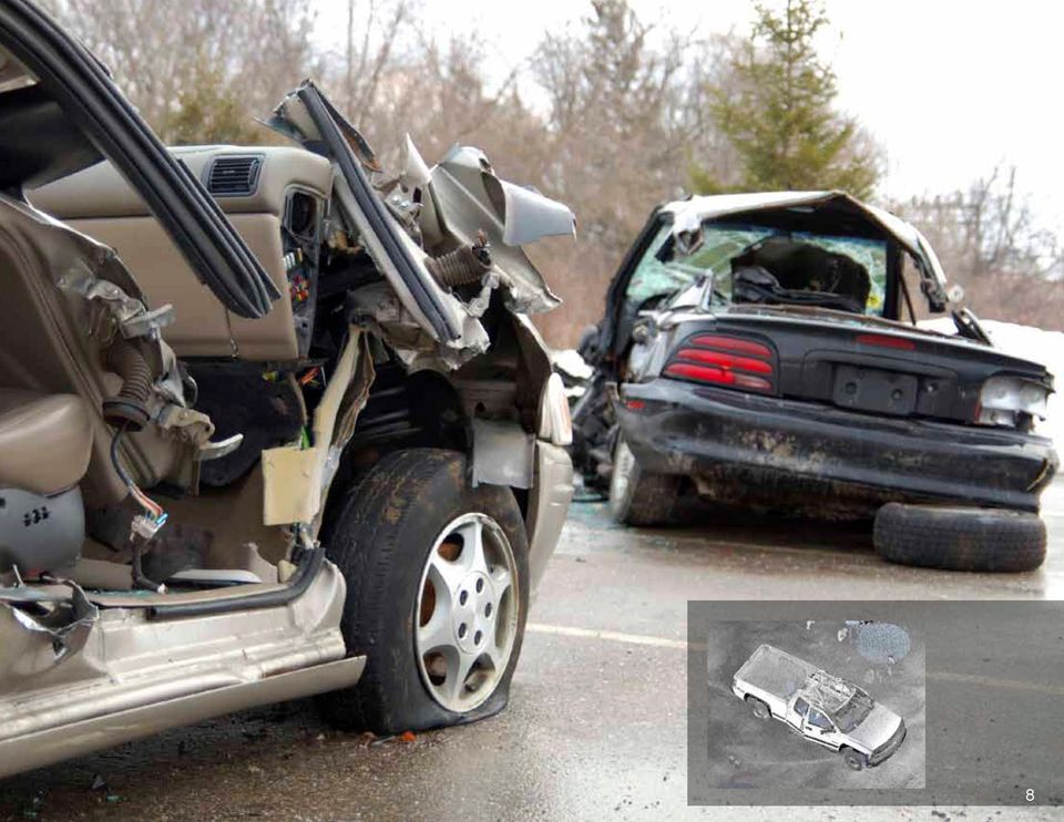
8 Real World Applications Accident Reconstruction Accident Reconstruction is the determination of the sequence of events which resulted in an accident or failure through analysis, observation and study. Applying the Laser Scanner Focus 3D will allow you to: Gather vast amounts of data quickly and bring the virtual scene back to the office Easily share data with clients over the web with one-click publishing Perform virtual surveying to support legacy workflows Create true-to-life visual recreations Analyze line of sight and environmental factors from various vantage points Compare scan data with OEM CAD files for vehicle deformation analysis Save time and produce superior deliverables Industries Served: Accident Investigation, Biomechanics Research, Fire Investigation, Forensic Engineering, Law Enforcement

9 8
10

11 Real World Applications As-Built Documentation As-Built Documentation is the process of describing an object or structure as it appears in its current state in the real world through the use of manual or digital documentation. Applying the Laser Scanner Focus 3D will allow you to: Bring the facility or object back to the office to avoid return site trips Create conceptual fly through videos blending existing and proposed structures to sell projects Extract as much or little information as you need, when you need it Create accurate 2D and 3D documentation for architects or engineers to facilitate renovations, additions, or repurposing Create a Building Information Model (BIM) for contractor collaboration, energy studies, facility management, and more Monitor construction for accuracy and create close out as-built documentation after each trade or phase is finished Perform off-site pre-fabrication of building components Monitor structures over time for attrition and settling Save time and produce superior deliverables Industries Served: Architecture, Civil Engineering, Construction, Facility Management, Heritage, Real Estate 10

12 W e k n e w h o w f a s t t h e FA R O L a s e r S c a n n e r w o r k e d a n d i t s e x t r e m e d e t a i l o f t h e i m a g e s t h a t i t p r o d u c e d. I t s e e m e d l i k e a n a t u r a l f i t f o r r e c o n s t r u c t i n g c r i m e o r a c c i d e n t s c e n e s. D o u g U r s e l, O p e r a t i o n s M a n a g e r P i n e F a l l Te c h n i c a l S e r v i c e s Real World Applications Crime Scene & Forensic Crime Scene & Forensic Investigation involves the use of scientific methods, physical evidence, deductive reasoning, and their inter-relationships to gain explicit knowledge of the series of events that surround the crime. Applying the Laser Scanner Focus 3D will allow you to: Quickly and thoroughly document a crime scene in color Virtually visit a crime scene again and again to verify witness testimony or evaluate hypotheses Work with the diagramming tools you are already familiar with Easily create annotated fly-through videos for court presentation Analyze line of sight, blood spatter, bullet trajectories, and offender s height (from video surveillance) Return scene to civilian use quickly Save time and produce superior deliverables Industries Served: Crime Investigation, Insurance, Law Enforcement, Legal, Military

13 12

14
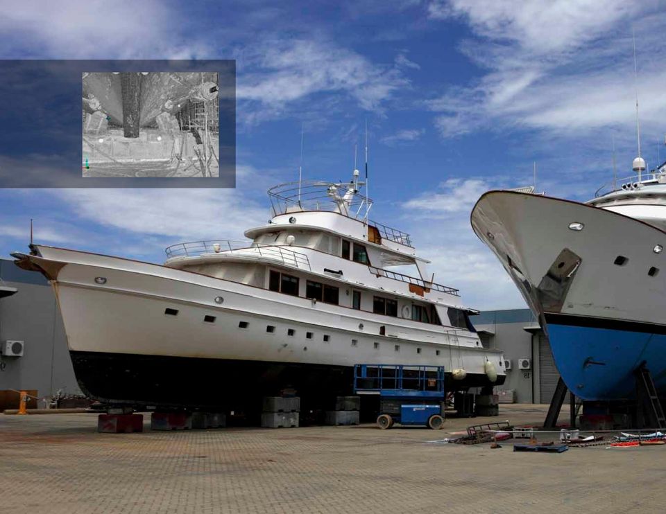
15 O u r n e w h i g h - s p e e d l a s e r s c a n n i n g c a p a b i l i t i e s g i v e s u s a n e f f i c i e n t, c o s t - e f f e c t i v e p r o c e s s f o r r e c o r d i n g s u r v e y i n f o r m a t i o n i n a p o w e r f u l, p r e v i o u s l y u n e x p l o i t e d f o r m a t. B M T s c u s t o m e r s h a v e a l w a y s a p p r e c i a t e d o u r i n n o v a t i v e, w o r k a b l e s o l u t i o n s a n d t h e FA R O L a s e r S c a n n e r c e r t a i n l y h e l p s u s t o m e e t t h e i r b u d g e t s a n d n e e d s. S t e v e C a r t e r, S e n i o r E n g i n e e r - B M T D e f e n s e S e r v i c e s Real World Applications Inspection/Reverse Engineering Inspection is the process of examining a part to determine if it conforms to outlined specifications during or after the production cycle. Reverse Engineering is the process of analyzing details on design, construction and operation to produce a copy or improved version of a product. Applying the Laser Scanner Focus 3D will allow you to: Generate precise 3D CAD documentation of complex machine components, molds, patterns, and fixtures Reverse engineer copies of large scale products and components when there is no existing CAD data available Quickly measure large, organic surfaces for inspection Measure red-hot objects at a safe distance, avoiding expensive cool down cycles Integrate the scanner with automation equipment and routines Extend time between relining of furnaces and ore crushers Pre-fabricate components, scan, and fit-up virtually in CAD Save time and produce superior deliverables Industries Served: Aerospace, Automotive, Boats & Yachts, Defense, Foundry, General Manufacturing, Ship-Building 14

16 Real World Applications Power & Process Power and Process is the function of documenting complex machinery, electrical components, piping, and associated equipment. Applying the Laser Scanner Focus 3D will allow you to: Accurately document as-built conditions to support engineering, even in very tight or complex spaces Reduce return visits to the site Simulate component replacement in 3D to minimize production downtime and avoid errors Perform nuclear walk-downs Identify piping tie-in points and clearances Perform clash detection between new designs and existing conditions Improve safety by remotely measuring difficult or dangerous areas, such as substations or hot zones Validate installations are to plan Provide physical data for asset management Monitor structural deflection Save time and produce superior deliverables Industries Served: Chemical, Food Processing, Energy, Mechanical Engineering, Petrochemical

17 12 16

18
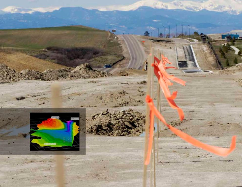
19 Real World Applications Surveying Surveying is the technique and science of accurately determining the terrestrial or three-dimensional position of points and the distances and angles between them. Applying the Laser Scanner Focus 3D will allow you to: Create topographical maps Generate accurate 2D CAD plan views, elevations, and section profiles Create 3D models Measure distances, areas, and volumes Map assets and check for clearance Detect construction deficiencies and deformations Produce navigation models for construction planning and tie-in identification Perform curb and gutter and field-to-finish work in the comfort of the office through virtual surveying Save time and produce superior deliverables Industries Served: Architecture, Civil Engineering, Construction, Heritage 18

20 Real World Applications Tunnel & Mining Tunnel and Mining is the process of excavating large amounts of earth to either mine resources or construct an underground passage for the transportation of vehicles, rail or water. Applying the Laser Scanner Focus 3D will allow you to: Capture the real tunnel profile and centerline for comparison with theoretical design Evaluate tunnel capacity for new demands Measure volume of extracted material Calculate tunnel grouting, shotcrete thickness, or reinforcements Gather geometric information of the cavity such as length, volume and shape Perform geological mapping in color Control machinery for accurate materials removal Save time and produce superior deliverables Industries Served: Construction, Energy, Infrastructure/DOT, Mining

21 12 20
22
23 Redesigned SCENE Software With the redesigned SCENE software, the time needed for post processing is dramatically minimized. Target recognition, target naming and scan registration are now automated. Therefore, the user only needs to check the final output of the automatic registration process and in many cases has the project complete upon return. In addition, the Focus 3D 120/20 laser scanners and SCENE now offer automatic 100% parallax-free, high-resolution, full quality color overlays. SCENE Software features: Fully automatic scan placement with or without reference targets Automatic digital level compensation to save up to 50% of targets Parallax-free automatic color overlay Cluster registration and geo-referencing supported Automatic generation of WebShare database Available for 64-bit Windows operating systems Improved color handling for Photon and Focus 3D scanners 22
24 FARO WebShare With the new SCENE software, the time needed for post processing is dramatically minimized. The new WebShare functionality is natively built into the SCENE software and requires no additional software to publish the scan data on the web. Scanned 3D images can now be put securely (password protected) on the Internet through password protection, thus enabling industries such as architecture, engineering and law enforcement to share scan information with engineers, owners, operators and clients without the need of additional software. Authorized users can view and download FARO laser scans of extensive projects using any standard web browser from anywhere in the world. FARO s QuickView offers the user a three-dimensional 360 photographic perspective of the FARO laser scan. Other advanced features of WebShare include: Overview map enables users to quickly find scan positions Transition points included in each scan makes it easy to switch from one scan to the next Authorized users can download scans for further analyzing using the free SCENE LT software WebShare is included with SCENE and is completely free
25 24
26
27 About FARO FARO is a global technology company that develops portable 3D measurement instruments for inspection, imaging, reverse engineering, and surveying. Our focus is on simplifying our customers work with tools that empower them to dramatically reduce their on-site measuring time and lower their overall costs. As the pioneer in portable computer-aided measurement, we apply our unique knowledge and understanding of our clients business goals to help them succeed. We empower our clients to exceed the demands placed upon them by applying the latest advances in technology to make FARO s industry leading product offerings more accurate, reliable, and easier to use. Our commitment to our customers extends well beyond product performance with FARO you have 3D measurement peace of mind. Each FARO team member is completely focused on simplifying our customers work, championing their innovation and ours, so our customers and their businesses can be more prosperous. 26
28 O n e o f t h e b i g g e s t r e a s o n s t h a t w e k e e p r e t u r n i n g t o FA R O f o r s o l u t i o n s i s b e c a u s e o f t h e s u p p o r t t h a t h a s b e e n p r o v i d e d t o u s o v e r t h e y e a r s. T h i s s u p p o r t h a s b e e n u n s u r p a s s e d. M A G C i n c i n n a t i The FARO Experience Your purchase is just the beginning of your partnership with FARO. Our employees are known for building relationships visiting your facility, getting to know your business, your processes, and providing measurement plans and training to help you get the most out of your FARO system. FARO operates service and calibration facilities around the world and all are ISO 9001:2001 certified and ISO laboratory registered to service FARO s products. Each center provides warranty and postwarranty services. At FARO, our goal is to service, inspect, calibrate, and return your equipment within a timely manner. FARO s training equips you with the knowledge necessary to execute measurements with confidence. From product setup, basic measurements, working with alignments and nominals, to advanced procedures and programming, we offer basic and advanced level classes at a FARO training center, or at your own facility. FARO also has experienced customer service representatives who offer telephone support for equipment or application-related questions. FARO and the FARO Logo are trademarks and registered trademarks of FARO Technologies Inc FARO Technologies Inc. All Rights Reserved. SFDC_04MKT_0241.pdf Created: 11/22/10
29 12 28
30 w w w. f a r o. c o m
BIM Department. BIM Modeling Using Faro Focus3D Laser Scanner
 BIM Modeling Using Faro Focus3D Laser Scanner Contents What is Laser Scanning? Advantages of Laser Scanning BIM Workflow Process Scanner Unit Set-up and Scanning Processing Scan Files BIM Software Creating
3D Laser Scanning Software Solutions
 3D Laser Scanning Software Solutions www.lfm-software.com LFM Software Overview Realise the true value of your laser scan data. Outside the EPC environment, Owner Operators are now also recognising the
3D Laser Scanning Technology. Rugged hardware and powerful software combined with streamlined survey workflow
 3D Laser Scanning Technology Rugged hardware and powerful software combined with streamlined survey workflow Maptek specialises in the research, development and application of 3D laser scanning technology.
IP-S3 HD1. Compact, High-Density 3D Mobile Mapping System
 IP-S3 HD1 Compact, High-Density 3D Mobile Mapping System Integrated, turnkey solution Ultra-compact design Multiple lasers minimize scanning shades Unparalleled ease-of-use No user calibration required
VERSATILE AND EASY-TO-USE 3D LASER SCANNERS > >
 VERSATILE AND EASY-TO-USE 3D LASER SCANNERS > > A WORLD OF APPLICATIONS 3D Systems, producers of the industry s fastest, easiest-to-use and most versatile 3D scanners, makes 3D scanning ideal for a wide
VERSATILE AND EASY-TO-USE 3D LASER SCANNERS > >
 VERSATILE AND EASY-TO-USE 3D LASER SCANNERS > > A WORLD OF APPLICATIONS Z Corporation, producers of the industry s fastest, easiest-to-use and most versatile 3D scanners, makes 3D scanning ideal for a
Trimble Realworks Software
 TECHNICAL NOTES Trimble Realworks Software A Powerful 3D Laser Scanning Office Software Suite DESIGNED FOR TODAY S MULTIFACETED SCANNING PROFESSIONAL, TRIMBLE REALWORKS IS A POWERFUL OFFICE SOFTWARE THAT
Specifying Laser Scanning Services. A Quantapoint White Paper
 A Quantapoint White Paper ABSTRACT Specifying Laser Scanning Services to Help Ensure Trusted and Accurate Results As-built documentation created using laser scanning is rapidly being adopted as the tool
technical notes trimble realworks software
 technical notes trimble realworks software A POWERFUL 3D LASER SCANNING OFFICE SOFTWARE SUITE Designed for today s multifaceted scanning professional, Trimble RealWorks is a powerful office software that
Laser Scanning for an Integrated BIM
 Laser Scanning for an Integrated BIM By: Duane Gleason Lake Constance 5D-Conference 2013 Constance, 28th-29th of October Introduction The application of laser scanning technology has been popular in the
Certified Instructors & Curriculum
 Our Promise. TPM is dedicated to provide the most extensive and high-quality training programs to help you maximize your investment. Although the investment in time and money may seem substantial, it will
Innovative capture and modeling of existing building conditions using 3D laser scanning. Entry B Submission
 Innovative capture and modeling of existing building conditions using 3D laser scanning Entry B Submission Executive Summary As a large owner organization, understanding and developing new technologies
3D Laser Scanning For Digital Modeling & Documentation
 3D Laser Scanning For Digital Modeling & Documentation Company Profile Direct Dimensions is dedicated to tackling the most difficult challenges with the most advanced 3D technologies available. Direct
PRODUCT BROCHURE SPATIAL ANALYZER. Powerful, traceable and easy-to-use metrology and analysis software
 PRODUCT BROCHURE SPATIAL ANALYZER Powerful, traceable and easy-to-use metrology and analysis software SPATIAL ANALYZER SpatialAnalyzer (SA) is a powerful, traceable and easy to use metrology and analysis
Leica Public Safety Solutions Versatile. Durable. Admissible. Services
 Leica Public Safety Solutions Versatile. Durable. Admissible Services Public Safety Solutions 3D Laser Scanners Software Training and Consulting Services Leica ScanStation PS Series Professional Grade
3D REVERSE ENGINEERING SOFTWARE
 3D REVERSE ENGINEERING SOFTWARE PRODUCT WORKFLOWS GEOMAGIC STUDIO WORKFLOW SCAN AND PROBE Collect 3D point cloud and probe data from physical objects to form the basis of the new 3D model. PROCESS Use
Olilo's AEC Design Services. SrinSoft Inc, Partners of
 Olilo's AEC Design Services SrinSoft Inc, Partners of Olilo provides design services that include design and analysis, cost estimation, 3D modeling, 2D drafting, conversion from 2D to 2D, quantity take-off,
Construction layout and scanning solutions for the MEP contractor
 Middle East Construction layout and scanning solutions for the MEP contractor Trimble Field Solutions Trimble Robotic Total Stations and 3D scanners allow you to both layout your MEP services as designed,
Laser Scanning Surveying and Ground Penetrating Radar The Full Three Dimensional Picture Above and Below Ground
 Laser Scanning Surveying and Ground Penetrating Radar The Full Three Dimensional Picture Above and Below Ground CIVILEX 2009 Mark Hudson, Director, Coastway, FInstCES MRICS MIS BTS Jeff Hott, Laser Scanning
IP-S2 Compact+ 3D Mobile Mapping System
 IP-S2 Compact+ 3D Mobile Mapping System 3D scanning of road and roadside features Delivers high density point clouds and 360 spherical imagery High accuracy IMU options without export control Simple Map,
Product and Service Catalog 2009 Direct Dimensions, Inc.
 Product and Service Catalog 2009 LASER SCANNERS... 4 SURPHASER LASER SCANNER... 4 DIMENSIONAL IMAGING DI3D... 4 VIALUX Z-SNAPPER 3D CAMERA... 4 KONICA MINOLTA RANGE7 3D DIGITIZER... 4 KONICA MINOLTA VIVID
High speed 3D capture for Configuration Management DOE SBIR Phase II Paul Banks [email protected]
 High speed 3D capture for Configuration Management DOE SBIR Phase II Paul Banks [email protected] Advanced Methods for Manufacturing Workshop September 29, 2015 1 TetraVue does high resolution 3D
Hexagon Ventures offers the next generation of smart solutions for business verticals.
 1 2 Hexagon Geosystems offers products and services from leading brands such as Leica Geosystems. solutions are trusted worldwide to capture, analyse, and present spatial information. Hexagon Geospatial
Revit MEP. Autodesk Navisworks
 What is BIM? Autodesk BIM is an intelligent model-based process that helps owners and service providers achieve business results by enabling more accurate, accessible, and actionable insight throughout
I-SiTE - Laser Scanning Revolutionises Site Survey
 I-SiTE - Laser Scanning Revolutionises Site Survey I.K. Kapageridis Maptek/KRJA Systems Ltd, United Kingdom ABSTRACT: MAPTEK's revolutionary I-SiTE 3D Laser Imaging System, presented in this paper, is
The crime scene sketch is an invaluable aid in recording
 Chapter 4 Crime Scene Sketch The crime scene sketch is an invaluable aid in recording investigative data. It is a permanent record that provides supplemental information that is not easily accomplished
3D Laser Scanning for Manufacturing Facilities Developing the Business Case. By Bill Campbell Founder, Digital Dimensions 360, LLC
 3D Laser Scanning for Manufacturing Facilities Developing the Business Case By Bill Campbell Founder, Digital Dimensions 360, LLC Table of Contents Introduction The Importance of Accuracy Workflow and
Go!SCAN 3D: FAST AND EASY 3D SCANNING
 Go!SCAN 3D: FAST AND EASY 3D SCANNING PORTABLE 3D MEASUREMENT SOLUTIONS The statue is part of the heritage of the Fabrique Saint-Augustin (Saint-Augustin-de-Desmaures) Creaform presents Go!SCAN 3D, a simple,
Optical Digitizing by ATOS for Press Parts and Tools
 Optical Digitizing by ATOS for Press Parts and Tools Konstantin Galanulis, Carsten Reich, Jan Thesing, Detlef Winter GOM Gesellschaft für Optische Messtechnik mbh, Mittelweg 7, 38106 Braunschweig, Germany
3D Laser Scanner. Extra long range laser scanner combined with a high resolution digital panoramic camera
 3D Laser Scanner Fast, PORTABLE, accurate Extra long range laser scanner combined with a high resolution digital panoramic camera INTRODUCING THE MAPTEK I-SITE 8800 LASER SCANNER > From Pit to Mine Model
CAD Techniques Helping To Enhance NDT Workflow
 CAD Techniques Helping To Enhance NDT Workflow Steve McCarley Eclipse Sientific Products Inc. www.eclipsescientific.com This document will show you some applied techniques and uses of CAD to solve some
Automotive Applications of 3D Laser Scanning Introduction
 Automotive Applications of 3D Laser Scanning Kyle Johnston, Ph.D., Metron Systems, Inc. 34935 SE Douglas Street, Suite 110, Snoqualmie, WA 98065 425-396-5577, www.metronsys.com 2002 Metron Systems, Inc
APPLICATION OF CLOSE RANGE PHOTOGRAMMETRY IN CRIME SCENE INVESTIGATION (C.S.I.) MAPPING USING IWITNESS AND CRIME ZONE SOFTWARE
 MAPPING USING IWITNESS AND CRIME ZONE SOFTWARE") APPLICATION OF CLOSE RANGE PHOTOGRAMMETRY IN CRIME SCENE INVESTIGATION (C.S.I.) MAPPING USING IWITNESS AND CRIME ZONE SOFTWARE Saiful Adilin Bin Ab Aziz, Zulkepli Bin Majid, Halim Bin Setan UTM-Photogrammetry
APPLICATION OF CLOSE RANGE PHOTOGRAMMETRY IN CRIME SCENE INVESTIGATION (C.S.I.) MAPPING USING IWITNESS AND CRIME ZONE SOFTWARE Saiful Adilin Bin Ab Aziz, Zulkepli Bin Majid, Halim Bin Setan UTM-Photogrammetry
for AutoCAD The professional s choice for Building Services
 for AutoCAD The professional s choice for Building Services With MagiCAD, all modelling is highly automated, fast and accurate. Checking the model and simulating the operation of different systems is easy
VISUALISATION Bring your concepts to life
 The Igloo 360 is a fullyimmersive, highly-engaging visualisation platform. You can step right inside your Computer-aided Design (CAD) and Business Information Modelling (BIM) data. You can get a palpable
Land Mobile Mapping & Survey
 Land Mobile Mapping & Survey Trimble Geospatial Solutions Trimble s geospatial solution portfolio has been designed to put information to work. Mobile sensors on the land, in the air or indoors capture
Industrial Metrology and Engineering Applications in the Wind Turbine Industry
 Industrial Metrology and Engineering Applications in the Wind Turbine Industry 1. Company Introduction M-7 Technologies is a privately owned, ISO 9001 certified company offering engineered solutions for
SPAR emedia Marketing Kit
 SPAR emedia Marketing Kit The online media platform for SPAR Point Group AUDIENCE Who are they? Project Managers Design Leaders Asset Managers Engineering Managers Maintenance Managers Survey Heads LIDAR
Proper Implementation of Industrial CT Scanning to Reduce Inspection Costs & Get to Production Faster. Jesse Garant, JG&A Metrology Center
 Proper Implementation of Industrial CT Scanning to Reduce Inspection Costs & Get to Production Faster Jesse Garant, JG&A Metrology Center Traditional Metrology and Inspection Tactile Devices (Touch Probe)
INTEGRATING BIM AND GIS FOR ASSET MANAGEMENT
 INTEGRATING BIM AND GIS FOR ASSET MANAGEMENT Andy Chan MHKIBIM Project Manager Spatial Technology Limited Agenda Introduction of Asset Management Why GIS is not sufficient for Asset Management Data model
3D SCANNING: A NEW APPROACH TOWARDS MODEL DEVELOPMENT IN ADVANCED MANUFACTURING SYSTEM
 3D SCANNING: A NEW APPROACH TOWARDS MODEL DEVELOPMENT IN ADVANCED MANUFACTURING SYSTEM Dr. Trikal Shivshankar 1, Patil Chinmay 2, Patokar Pradeep 3 Professor, Mechanical Engineering Department, SSGM Engineering
Types of 3D Scanners and 3D Scanning Technologies.
 Types of 3D Scanners and 3D Scanning Technologies. There are many types of 3D scanners and 3D scanning technologies. Some are ideal for short range scanning while others are better suited for mid or long
Autodesk Revit LEARNING PATH BUILDING DESIGN SUITE
 Autodesk Revit LEARNING PATH FUNDAMENTALS Duration: 3 days Cost: R5 500 (excl VAT) Revit MEP Duration: 3 days Cost: R5 500 (excl VAT) Revit Structure Duration: 3 days Cost: R5 500 (excl VAT) REVIT ADVANCED
3D SCANNING SOLUTION FOR PIPELINE INTEGRIT Y ASSESSMENT!
 NDT SOLUTIONS 3D SCANNING SOLUTION FOR PIPELINE INTEGRIT Y ASSESSMENT! CODE-COMPLIAN T PORTABLE 3D MEASUREMENT SOLUTIONS Pipeline operators and NDT service companies must deal with increasing pressure
The Shorten AutoCAD the road solution for mechanical, electrical, to done. and plumbing engineering. AutoCAD AutoCAD.
 The Shorten AutoCAD the road solution for mechanical, electrical, to done. and plumbing engineering. AutoCAD AutoCAD Civil 3D MEP 2009 More Productivity, Same Skills Michigan-based Peter Basso Associates
IP-S2 HD. High Definition 3D Mobile Mapping System
 IP-S2 HD High Definition 3D Mobile Mapping System Integrated, turnkey solution High Density, Long Range LiDAR sensor for ultimate in visual detail High Accuracy IMU and DMI Odometry for positional accuracy
Building Information Modeling (BIM) Requirements for PT Projects Today s Capabilities for a BIM based Design
 Requirements for PT Projects Today s Capabilities for a BIM based Design") Building Information Modeling (BIM) Requirements for PT Projects Today s Capabilities for a BIM based Design Florian Aalami CEO ADAPT Corporation [email protected] What is BIM? The ability to model
Building Information Modeling (BIM) Requirements for PT Projects Today s Capabilities for a BIM based Design Florian Aalami CEO ADAPT Corporation [email protected] What is BIM? The ability to model
University Rd., Tainan, Taiwan, R.O.C., [email protected]
 THE DIGITAL RECONSTRUCTION OF A LARGE-SCALE CONSTRUCTION SIMULATED BY USING 3D LASER SCANNING TECHNOLOGY A BRICK KILN S CHIMNEY IN KAOHSIUNG CITY OF TAIWAN AS AN EXAMPLE Yi-Chun LIN 1, Tsung-Chiang WU
Pipeline External Corrosion Analysis Using a 3D Laser Scanner
 Pipeline Technology Conference 2013 Pipeline External Corrosion Analysis Using a 3D Laser Scanner Pierre-Hugues ALLARD, Charles MONY Creaform, www.creaform3d.com 5825 rue St-Georges, Lévis (QC), Canada,
SMARTPLANT ENTERPRISE
 INDUSTRY SMARTPLANT ENTERPRISE For the Metals and Mining Industry INDUSTRY CHALLENGES Metals and mining facilities are increasingly complex and large in scope, with mega-projects becoming the norm. There
How To Use Autocad Design Suite 2013
 AutoCAD Design Suite 2013 Questions and Answers For the people who shape and create the world around us, AutoCAD Design Suite 2013 includes the most powerful AutoCAD software ever, plus tools to help you
DAMAGED ROAD TUNNEL LASER SCANNER SURVEY
 University of Brescia - ITALY DAMAGED ROAD TUNNEL LASER SCANNER SURVEY Prof. Giorgio Vassena [email protected] WORKFLOW - Demand analysis - Instruments choice - On field operations planning - Laser
SMART Collaboration Solutions A better way to work together
 SMART Collaboration Solutions A better way to work together Intuitive displays and projectors Turn virtually any environment into a dynamic collaboration space. SMART Room System for Microsoft Lync Combine
Computer Aided Design and Drafting (CAD)
") Oakland Community College 2015-2016 Catalog 1 Computer Aided Design and Drafting (CAD) CAD 1050 Geometric Dimensioning and Tolerancing (GD&T) This course is designed to cover the fundamentals as well as
Oakland Community College 2015-2016 Catalog 1 Computer Aided Design and Drafting (CAD) CAD 1050 Geometric Dimensioning and Tolerancing (GD&T) This course is designed to cover the fundamentals as well as
Design without compromise. Autodesk Revit. Architecture 2010
 Design without compromise. Autodesk Revit Architecture 2010 BIM Simply a Better Way of Working Deliver projects faster, more economically, and with enhanced potential for reduced environmental impact.
Differentiation of 3D scanners and their positioning method when applied to pipeline integrity
 11th European Conference on Non-Destructive Testing (ECNDT 2014), October 6-10, 2014, Prague, Czech Republic More Info at Open Access Database www.ndt.net/?id=16317 Differentiation of 3D scanners and their
T-REDSPEED White paper
 T-REDSPEED White paper Index Index...2 Introduction...3 Specifications...4 Innovation...6 Technology added values...7 Introduction T-REDSPEED is an international patent pending technology for traffic violation
Types of Engineering Jobs
 What Do Engineers Do? Engineers apply the theories and principles of science and mathematics to the economical solution of practical technical problems. I.e. To solve problems Often their work is the link
Building Information Modeling for MEP Engineering. Revit MEP 2008
 Building Information Modeling for MEP Engineering Revit MEP 2008 Design Intuitively with Tools That Work the Way Engineers Think Revit MEP software is an intuitive design tool that works the way engineers
The PTC Creo Suite of NC and Tooling Solutions
 The PTC Creo Suite What you need to capitalize on global manufacturing excellence of NC and Tooling Solutions To gain a competitive edge in product development, companies are increasingly leveraging globally
Autodesk Solutions for Environmental Engineering. Engineering a better environment
 Autodesk Solutions for Environmental Engineering Engineering a better environment Better Engineering, Faster Design and deliver environmental engineering projects better, faster, and more economically.
USING MOBILE LIDAR TO SURVEY A RAILWAY LINE FOR ASSET INVENTORY INTRODUCTION
 USING MOBILE LIDAR TO SURVEY A RAILWAY LINE FOR ASSET INVENTORY a Michael Leslar, Sales and Marketing Support Engineer b Gordon Perry, Senior Project Manager b Keith McNease, Principal a Optech Incorporated
Autodesk Revit Architecture. Design without compromise.
 Autodesk Revit Architecture Design without compromise. Definitive Design From conception to construction documentation, design projects within an intuitive environment. Building information modeling and
A Simple Guide To Understanding 3D Scanning Technologies
 A Simple Guide To Understanding 3D Scanning Technologies First Edition www.lmi3d.com Table of Contents Introduction At LMI Technologies, solving complex problems in a simple way is the philosophy that
ASSESSMENT OF VISUALIZATION SOFTWARE FOR SUPPORT OF CONSTRUCTION SITE INSPECTION TASKS USING DATA COLLECTED FROM REALITY CAPTURE TECHNOLOGIES
 ASSESSMENT OF VISUALIZATION SOFTWARE FOR SUPPORT OF CONSTRUCTION SITE INSPECTION TASKS USING DATA COLLECTED FROM REALITY CAPTURE TECHNOLOGIES ABSTRACT Chris Gordon 1, Burcu Akinci 2, Frank Boukamp 3, and
TRIMBLE 3D SCANNING FOR SURVEYORS
 TRIMBLE 3D SCANNING FOR SURVEYORS T. LEMMON & P. BIDDISCOMBE TRIMBLE SURVEY, WESTMINSTER, COLORADO, USA ABSTRACT 3D Scanning is a powerful technology that uses advanced laser measurement technology to
Application Report. Propeller Blade Inspection Station
 34935 SE Douglas Street, Suite, Snoqualmie, WA 9874 Ph: 425-396-5577 Fax: 425-396-586 Application Report Propeller Blade Inspection Station Prepared By Kyle Johnston, Ph. D. Metron Systems Inc.5.5 3 2.5
Adobe Anywhere for video Collaborate without boundaries
 Introducing Adobe Anywhere for video Collaborate without boundaries As a professional video producer, you face a growing demand for more content on a widening variety of devices and platforms. Today s
2012 BIM Guidelines and Standards (Rev. 00) University at Albany
 University at Albany") A. Building Information Modeling (BIM) Guidelines: The Office of AECM will require the submission of BIM modeling files as part of an electronic file submission to the AECM project manager as requested
A. Building Information Modeling (BIM) Guidelines: The Office of AECM will require the submission of BIM modeling files as part of an electronic file submission to the AECM project manager as requested
Advancements in Close-Range Photogrammetry for Crime Scene Reconstruction
 Advancements in Close-Range Photogrammetry for Crime Scene Reconstruction Lee F. DeChant [email protected] Abstract: Police investigators and forensic technicians often face challenges in obtaining
PreciTrack3D GmbH. PRECI 3D TRACK PRECI 3D GUN PRECI 3D SCAN PRECI 3D ROBOGUN PRECI 3D CONFOCAL PRECI 3D REF Tube Inspection & Measurements PRODUCTS
 HIGHLIGHTS 3D Real Time Tracking Quality Control & Inspection Reverse Engineering ID 2D 3D Scanning PRODUCTS PRECI 3D TRACK PRECI 3D SCAN PRECI 3D CONFOCAL PRECI 3D REF Tube Inspection & Measurements PRECI
Property Management and Data Visualization Solution with Autodesk and the Oracle E-Business Suite
 Property Management & Visualization White Paper Property Management and Visualization Solution with Autodesk and the Oracle E-Business Suite This paper presents the value and benefits of the integrated
GEOGRAPHIC INFORMATION SYSTEMS (GIS): THE BEDROCK OF NG9-1-1
: THE BEDROCK OF NG9-1-1") GEOGRAPHIC INFORMATION SYSTEMS (GIS): THE BEDROCK OF NG9-1-1 THE TIME IS NOW FOR PSAPS AND REGIONAL AGENCIES TO TAKE ADVANTAGE OF THE ACCURATE GEOSPATIAL DATABASES THAT WILL BE KEY TO NEXT GENERATION EMERGENCY
GEOGRAPHIC INFORMATION SYSTEMS (GIS): THE BEDROCK OF NG9-1-1 THE TIME IS NOW FOR PSAPS AND REGIONAL AGENCIES TO TAKE ADVANTAGE OF THE ACCURATE GEOSPATIAL DATABASES THAT WILL BE KEY TO NEXT GENERATION EMERGENCY
The user forum is an excellent community in which to bounce questions off other professional users, like you.
 INTRODUCTION Thank you for your interest in MicroSurvey Point Prep Point Prep is a simple to use desktop based product designed specifically for the construction layout professional. Point Prep is used
Rule-Based Ship Design
 Rule-Based Ship Design A White Paper Process, Power & Marine, a division of Intergraph Table of Contents 1. Introduction... 1 2. Advantages to Rule-Based Design... 2 2.1 Embedding Design Practices...2
Design without compromise. Autodesk Revit. Architecture
 Design without compromise. Autodesk Revit Architecture Definitive Design From conception to construction documentation, design projects within an intuitive environment. Building information modeling and
1. Introduction. 2. The benefit of IP Technology. 2.1 Market trend. 2.2 Analog video surveillance system
 WHITE PAPER Upgrading Analog Video Surveillance System with IP Technology Panasonic Video surveillance systems Table of contents 1. Introduction 3 2. The benefit of IP Technology 3 3. Upgrade strategies
BIM: FOR PROJECT MANAGERS. 2011 CSI Southwest Region Conference Program 1B 8:45am 11:00am
 BIM: FOR PROJECT MANAGERS ANA BAKER BRANDON GARRETT 2011 CSI Southwest Region Conference Program 1B 8:45am 11:00am 1 2 3 4 BIM Overview BIM Level of Development Evolution of the Drawing Process BIM Workflow
Performance by design. Autodesk Revit MEP
 Performance by design. Autodesk Revit MEP Step up to the challenge. Autodesk Revit MEP software helps mechanical, electrical, and plumbing engineering firms meet the heightened demands of today s global
3D SCANNING SOLUTION FOR PIPELINE INTEGRIT Y ASSESSMENT!
 NDT SOLUTIONS 3D SCANNING SOLUTION FOR PIPELINE INTEGRIT Y ASSESSMENT! CODE-COMPLIANT Pipeline operators and NDT service companies must deal with increasing pressure from regulation authorities and environmentalists
How SolidWorks Speeds Consumer Product Design
 white paper How SolidWorks Speeds Consumer Product Design inspiration SUMMARY SolidWorks Premium bridges the gap between industrial design and engineering by providing powerful surfacing capabilities,
Tuxedo Touch INFORMATION FOR SECURITY DEALERS. Connect to Opportunity with the Connected Home and Business
 Tuxedo Touch INFORMATION FOR SECURITY DEALERS Connect to Opportunity with the Connected Home and Business Tuxedo Touch and Honeywell Total Connect a Great New Opportunity! Advanced home and business security
The use of BIM in plumbing projects creates deeper project knowledge, delivers a more robust product, and can reduce total project costs.
 BIM for plumbing design The use of BIM in plumbing projects creates deeper project knowledge, delivers a more robust product, and can reduce total project costs. BY JUNCHENG (JAMES) YANG, PE, CPD, LEED
T-SERIES. thermal IMAGING CAMERAS FoR PREDICtIVE MAINtENANCE UNLEASH THE ULTIMATE POWER OF FLIR
 T-SERIES thermal IMAGING CAMERAS FoR PREDICtIVE MAINtENANCE UNLEASH THE ULTIMATE POWER OF FLIR T-SERIES the ultimate thermal IMAGER PRoDuCtIVItY boost Touchscreen tools as intuitive as a smartphone s Simple
Manufacturing Process and Cost Estimation through Process Detection by Applying Image Processing Technique
 Manufacturing Process and Cost Estimation through Process Detection by Applying Image Processing Technique Chalakorn Chitsaart, Suchada Rianmora, Noppawat Vongpiyasatit Abstract In order to reduce the
Integration Services
 Integration Services EXPERIENCED TEAM ADVANCED TECHNOLOGY PROVEN SOLUTIONS Integrations for large scale metrology applications Metris metrology to streamline your CAPABILITIES Advanced systems design Engineering
Responsibilities of Engineering Surveyors under ISO 9000 in Hong Kong Construction Industry
 Responsibilities of Engineering Surveyors under ISO 9000 in Hong Kong Construction Industry Steve Y. W. Lam and Conrad H. W. Tang Department of Land Surveying & Geo-Informatics Hong Kong Polytechnic University,
Asset Data: A New Beginning, A New AURIZON. OmniSurveyor3D - The one source of truth
 Asset Data: A New Beginning, A New AURIZON OmniSurveyor3D - The one source of truth Gerard Buckett Program Manager, Asset Management Improvement, Aurizon Network 30 years experience in rail engineering
PRODUCT INFORMATION. SICK LifeTime Services. LifeTime Services for Machines and Systems
 PRODUCT INFORMATION SICK LifeTime Services LifeTime Services for Machines and Systems Ordering Information Place your trust in us... SICK LifeTime Services Place your trust in us... SICK LifeTime Services
A Conceptual Methodology and Practical Guidelines for Managing Data and Documents on Hydroelectric Projects
 A Conceptual Methodology and Practical Guidelines for Managing Data and Documents on Hydroelectric Projects Alan Hodgkinson SoftXS GmbH Alpensrasse 14 CH-6300 Zug Switzerland Joseph J Kaelin Pöyry Infra
FLIR i-series Point-and-Shoot Thermal Imaging Cameras
 FLIR i-series Point-and-Shoot Thermal Imaging Cameras Missing insulation and water damage. Hot electrical component. Hot pipe and water leak in wall. Compact and Rugged Groundbreaking Affordability Easy
Effective Collaboration using Revit Structure and AutoCAD MEP
 REVIT STRUCTURE Effective Collaboration using Revit Structure and AutoCAD MEP This white paper explains how structural engineers using Revit Structure software and mechanical/electrical/plumbing (MEP)
Press Release. Superior bending
 Superior bending An array of new features makes TRUMPF s new TruBend Series 5000 more productive and user-friendly than ever before. Using a new control concept, the machines are amazingly easy to operate.
City Surveillance and the Cloud
 Keep Watch on Your Projects Through the Cloud, 24/7/365 Unlock the all the potential tools of a modern enterprise video surveillance system with a costeffective and elegantly simple cloud video surveillance
Digital Prototyping: Questions and Answers
 Autodesk Manufacturing Digital Prototyping: Questions and Answers 1. What is a digital prototype? A digital prototype is created with Autodesk Inventor software and is a digital simulation of a product
Pipeline Engineering. Natural Gas Distribution
 R Pipeline Engineering Natural Gas Distribution Gas Distribution Engineering Services Our team of professionals at EN Engineering has been designing, upgrading and maintaining distribution system assets
Geospatial Technologies integrated with Building Information Modelling on Large Construction Site for Health and Safety Management
 Geo-IT: The Enabler Ingredient in the Infrastructure Construction Project Life Cycle Mix Geospatial Technologies integrated with Building Information Modelling on Large Construction Site for Health and