Latitude, Longitude, and Time Zones
|
|
|
- Caren Robertson
- 9 years ago
- Views:
Transcription
1 Latitude, Longitude, and Time Zones
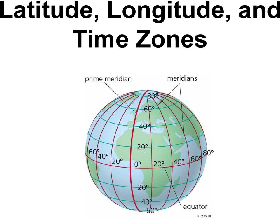
2 Typical Graph This is an example of a typical graph. It is made up of points that are connected by a line.

3 Y axis Typical Graph Each point has two values: (4,7) An X value that runs along the horizontal X axis and... A Y value that runs along the vertical Y axis X axis Each point is expressed as an X value and a Y value with the X value written first. For example... and... 7,5)

4 Typical Graph (-X,+Y) Y (+X,+Y) X Graphs may be divided into quadrants with the X and Y values being either positive (+) or negative (-) depending on the quadrant in which they are located. (-X,-Y) (+X,-Y) Now let s apply the same principles to latitude and longitude.
 (+X,-Y) Now let s apply the same principles to latitude")
5 90 N What is latitude? Latitude is the distance from the equator along the Y axis. It is expressed in degrees. 90 S 0 The north pole is 90 N The south pole is 90 S And remember that the equator is 0 latitude. What is the maximum possible latitude on Earth? 90 is maximum. You could be at 90 N or 90 S but there is no greater latitude on Earth (or anywhere else)

6 What is longitude? Longitude is the distance from the prime meridian along the X axis. Just like latitude, longitude is measured in degrees. The prime meridian is And if you go half way around the world you will reach the 180 longitude line. Understand that there aren t two 180 lines. On this FLAT map it just looks that way. It s the SAME line. What is the maximum possible longitude on Earth? 180 is the maximum possible longitude on Earth.

7 On the map horizontal lines are lines of latitude and... vertical lines are lines of longitude. The X axis is the equator Equator and the Y axis which runs through Greenwich, England is the Prime Meridian* Prime Meridian * A MERIDIAN is another name for a line of longitude

8 Any location north of the equator is a NORTH LATITUDE Where do most people on earth live?

9 Any location south of the equator is a SOUTH LATITUDE

10 Any location west of the prime meridian is a WEST LONGITUDE

11 Any location east of the prime meridian is an EAST LONGITUDE

12 We can divide the Earth into quadrants: NW where all latitudes are NORTH and all longitudes are WEST. Notice that EVERY point in the United States will have a NORTH latitude and a WEST longitude since we are in the NW quadrant.

13 60 N, 30 W 75 S, 75 E 15 S, 105 W Each box on this map is 15. With that in mind how can we identify specific locations (red dots)? Remember, write latitude first! (It s the x coordinate) What are the coordinates of location...a What are the coordinates of location...b What are the coordinates of location...c But what about location D? It s in the middle of a box. What do we do now?

14 43 N Let s look at Ithaca, NY, the home of Cornell University. 77 W 76 W The latitude is more than 42 N but less than 43 N and the longitude is more than 76 W but less than 77 W Ithaca 42 N We need to be more precise. We can do that by subdividing each degree into 60 smaller units called minutes.

15 If there are 60 minutes in each degree then half a degree would be 30 minutes. Let s draw in the 30 minute (30 ) line. See these 2 marks? They are half way (30 ) between 42 N and 43 N. Using a ruler, connect them. The line you just drew is N. Now let s look at lines of longitude. See these 2 marks? They are half way (30 ) between 76 W and 77 W. Using a ruler, connect them. The line you just drew is W. Now let s see if we can locate Ithaca more precisely.
 between 76 W and 77 W. Using a ruler, connect them. The line you just drew is 76 30 W.")
16 First comes latitude. Notice that Ithaca is just south of the N line. If it s not quite 30 then let s call it 25. Ithaca is located N. Now we ll do longitude which, for Ithaca is easy since it s located right on the W line. Ithaca s longitude is W. Now we ll put latitude and longitude together to give a precise location: Ithaca is N, W.

17 Here are some things to remember: > Latitude is written first and must always include N (north) or S (south) of the equator. > Longitude is written next and must always include E (east) or W (west) of the prime meridian. > Each degree of latitude or longitude can be divided into 60 minutes. > A minute, as used here, is a unit of distance on the earth s surface. It is not a unit of time. > Most of the time it will be impossible to be absolutely precise. Your best estimate might have to be to the nearest 5 or 10 minutes. In other words, an estimate of W is OK but W is trying to be more accurate than is reasonably possible.

18 Degrees and minutes Here is how you write degrees and minutes N (latitude) W (longitude) TOGETHER> N, W Latitude is always given first, followed by longitude. MNEMONIC Head for the HILLSS : High-Low Latitude, then Side to Side (longitude) Typing tip: for the degree symbol, ALT-0176 (Try it!)

19 LONGITUDE AND LATITUDE LATITUDE EQUATOR LONGITUDE MERIDIAN DEGREES

20 TIME ZONES

21 Why is an accurate system of time so important in our world? TRAVEL and TRANSPORTATION COMMUNICATIONS FINANCE??? I = PRT
22 PRIME MERIDIAN
23 INTERNATIONAL DATE LINE MONDAY SUNDAY Why the zigzag line? MNEMONIC Go EAST a day earlier; go West way later.
24 TIME ZONES Time zones are measured by reference to a specific point, namely the prime meridian which runs through Greenwich, England. The time at the prime meridian is referred to as Greenwich Mean TimeNote-taking -- GMT tip Key term on left In recent years it is becoming more common to use the more Followed by a dash accurate Coordinated Universal Time (abbreviated then paraphrase as UTC) which uses an atomic time clock to regulate world time. UTC at the prime meridian is used as a starting point to determine time worldwide. So, for example, if a country is stated as having the time UTC+3, this means that when it is 1:00 PM in Greenwich, it is 4:00 PM in that country.
25 There are 24* primary world time zones Each time zone spans approximately 15 degrees of longitude * Because of local and political considerations there are actually more than 24 officially recognized time zones
26 WORLD CLOCK
27 UTC-ZULU* time? If it s 12:00 PM GMT or UTC-ZULU time, what is the time in Los Angeles? In Ankara, Turkey? *Used by the military and others to indicate GMT time at the 0 meridian (prime meridian)
28 It s all the SAME! GMT = UTC-0 = UTC-ZULU
29 GMT = 2:00 PM So what time is it in UTC = 2:00 PM UTC-Zulu = 2:00 PM See page 25 in your NWAt OSLO, Norway? (UTC+1) = BOMBAY, India? (UTC+5) = CHICAGO? (UTC-6) = LOS ANGELES? (UTC-8) = UTC-0 time is now 2:00 PM
30 JET LAG? Many travelers find that they suffer from a condition known as 'jet lag' when they have crossed time zones. This is a physiological condition triggered by the body becoming out of sync with the usual light and dark patterns to which it is accustomed. The condition is characterized by numerous symptoms, such as extreme fatigue, disorientation and loss of appetite. Jet lag often takes many days to recover; a rough medical guideline being one day per time zone. Sleep is seen as one of the best cures for jet lag, as is exposure to sunlight.
31 US TIME ZONES
32 FOUR US TIME ZONES
33 ABBREVIATIONS EST EDT* CST CDT* MST PST AST HST *DST= Daylight Savings Time
34 24-Hour Time Often referred to as MILITARY or RAILROAD time. Based on 24-hour day 12:05 AM = 00:05 WHAT TIME IS IT? 1:00 AM = 01:00 (1) 3:30 AM = 2:00 AM = 02:00 (2) 2:00 PM = 2:45 AM = 02:45 (3) 11:20 AM = 7:30 AM = 07:30 (4) 7:52 PM = 12:00 PM = 12:00 (5) 11:59 PM = 1:00 PM = 13:00 (6) 12:15 AM = 8:30 PM = 16:30 (7) 12:15 PM =
35 Back to the INTERNATIONAL DATE LINE (IDL) What day is it here? MONDAY SUNDAY 11:59PM 12:00AM MNEMONIC Go EAST a day earlier; go West way later.
36 IDL explained (I hope!)
Activity 1 Reading Universal Time Level 2 http://www.uni.edu/storm/activities/level2/index.shtml
 Activity 1 Reading Universal Time Level 2 http://www.uni.edu/storm/activities/level2/index.shtml National Science Education Standards: As a result of activities in grades 5-8, all students should develop
Plotting Earthquake Epicenters an activity for seismic discovery
 Plotting Earthquake Epicenters an activity for seismic discovery Tammy K Bravo Anne M Ortiz Plotting Activity adapted from: Larry Braile and Sheryl Braile Department of Earth and Atmospheric Sciences Purdue
Lines of Latitude and Longitude
 ED 5661 Mathematics & Navigation Teacher Institute Keith Johnson Lesson Plan Lines of Latitude and Longitude Lesson Overview: This lesson plan will introduce students to latitude and longitude along with
Activity 10 - Universal Time
 Activity 10 - Universal Time Teacher s Guide Scientists use the Universal Time reference to talk about data that is taken around the globe. Universal Time is the time kept in the time zone centered on
The Globe Latitudes and Longitudes
 INDIAN SCHOOL MUSCAT MIDDLE SECTION DEPARTMENT OF SOCIAL SCIENCE The Globe Latitudes and Longitudes NAME: CLASS VI SEC: ROLL NO: DATE:.04.2015 I NAME THE FOLLOWING: 1. A small spherical model of the Earth:
World Map Lesson 4 - The Global Grid System - Grade 6+
 World Map Lesson 4 - The Global Grid System - Grade 6+ Activity Goal To use the global grid system of latitude and longitude to find specific locations on a world map. Materials Needed: A pencil, a ruler,
OBJECTIVES. Identify the means by which latitude and longitude were created and the science upon which they are based.
 Name: Key OBJECTIVES Correctly define: isolines, gradient, topographic map, contour interval, hachured lines, profile, latitude, longitude, hydrosphere, lithosphere, atmosphere, elevation, model EARTH
Fantasy flight. Investigation 7. Understanding the Investigation
 Investigation 7 Fantasy flight You have won a dre trip around the world, providing you with 50 000 km of free air travel to four major cities. Unfortunately, there is a catch! You have to pay for your
Basic Coordinates & Seasons Student Guide
 Name: Basic Coordinates & Seasons Student Guide There are three main sections to this module: terrestrial coordinates, celestial equatorial coordinates, and understanding how the ecliptic is related to
Noon Sun Angle = 90 Zenith Angle
 Noon Sun Angle Worksheet Name Name Date Subsolar Point (Latitude where the sun is overhead at noon) Equinox March 22 nd 0 o Equinox September 22 nd 0 o Solstice June 22 nd 23.5 N Solstice December 22 nd
Lines on Maps and Globes. Cross Curricular Writing Activity Social Studies Grade 4
 Lines on Maps and Globes Cross Curricular Writing Activity Social Studies Grade 4 Fourth Grade Social Studies Standard Map: Chart/Globe The learner will be able to use maps, charts, graphs, and globes
Sun Earth Relationships
 1 ESCI-61 Introduction to Photovoltaic Technology Sun Earth Relationships Ridha Hamidi, Ph.D. Spring (sun aims directly at equator) Winter (northern hemisphere tilts away from sun) 23.5 2 Solar radiation
Motion & The Global Positioning System (GPS)
") Grade Level: K - 8 Subject: Motion Prep Time: < 10 minutes Duration: 30 minutes Objective: To learn how to analyze GPS data in order to track an object and derive its velocity from positions and times.
Grade Level: K - 8 Subject: Motion Prep Time: < 10 minutes Duration: 30 minutes Objective: To learn how to analyze GPS data in order to track an object and derive its velocity from positions and times.
Astromechanics. 1 solar day = 1.002737909350795 sidereal days
 Astromechanics 13. Time Considerations- Local Sidereal Time The time that is used by most people is that called the mean solar time. It is based on the idea that if the Earth revolved around the Sun at
Celestial Observations
 Celestial Observations Earth experiences two basic motions: Rotation West-to-East spinning of Earth on its axis (v rot = 1770 km/hr) (v rot Revolution orbit of Earth around the Sun (v orb = 108,000 km/hr)
Lesson 26: Reflection & Mirror Diagrams
 Lesson 26: Reflection & Mirror Diagrams The Law of Reflection There is nothing really mysterious about reflection, but some people try to make it more difficult than it really is. All EMR will reflect
EARTHQUAKES. Compressional Tensional Slip-strike
 Earthquakes-page 1 EARTHQUAKES Earthquakes occur along faults, planes of weakness in the crustal rocks. Although earthquakes can occur anywhere, they are most likely along crustal plate boundaries, such
The Earth Really is Flat! The Globe and Coordinate Systems. Long History of Mapping. The Earth is Flat. Long History of Mapping
 The Earth Really is Flat! The Globe and Coordinate Systems Intro to Mapping & GIS The Earth is Flat Day to day, we live life in a flat world sun rises in east, sets in west sky is above, ground is below
What Causes Climate? Use Target Reading Skills
 Climate and Climate Change Name Date Class Climate and Climate Change Guided Reading and Study What Causes Climate? This section describes factors that determine climate, or the average weather conditions
An Introduction to Coordinate Systems in South Africa
 An Introduction to Coordinate Systems in South Africa Centuries ago people believed that the earth was flat and notwithstanding that if this had been true it would have produced serious problems for mariners
Solar Angles and Latitude
 Solar Angles and Latitude Objectives The student will understand that the sun is not directly overhead at noon in most latitudes. The student will research and discover the latitude ir classroom and calculate
Earth-Sun Relationships. The Reasons for the Seasons
 Earth-Sun Relationships The Reasons for the Seasons Solar Radiation The earth intercepts less than one two-billionth of the energy given off by the sun. However, the radiation is sufficient to provide
APPENDIX D: SOLAR RADIATION
 APPENDIX D: SOLAR RADIATION The sun is the source of most energy on the earth and is a primary factor in determining the thermal environment of a locality. It is important for engineers to have a working
Newton s Law of Gravity
 Gravitational Potential Energy On Earth, depends on: object s mass (m) strength of gravity (g) distance object could potentially fall Gravitational Potential Energy In space, an object or gas cloud has
Introduction to Geography
 High School Unit: 1 Lesson: 1 Suggested Duration: 3 days Introduction to Lesson Synopsis: The purpose of this lesson is to introduce students to geography and geography terminology, to teach students about
ATOMIC CLOCK WITH MOON PHASE. MODEL 86730 Instruction Manual
 ATOMIC CLOCK WITH MOON PHASE MODEL 86730 Instruction Manual FEATURES: WWVB Radio controlled time with manual time setting 12/24 hour time display Time display: hour, minute, second Alarm setting with snooze
Session 7 Bivariate Data and Analysis
 Session 7 Bivariate Data and Analysis Key Terms for This Session Previously Introduced mean standard deviation New in This Session association bivariate analysis contingency table co-variation least squares
Earth Coordinates & Grid Coordinate Systems
 Earth Coordinates & Grid Coordinate Systems How do we model the earth? Datums Datums mathematically describe the surface of the Earth. Accounts for mean sea level, topography, and gravity models. Projections
2.2 Derivative as a Function
 2.2 Derivative as a Function Recall that we defined the derivative as f (a) = lim h 0 f(a + h) f(a) h But since a is really just an arbitrary number that represents an x-value, why don t we just use x
Coordinate Systems. Orbits and Rotation
 Coordinate Systems Orbits and Rotation Earth orbit. The earth s orbit around the sun is nearly circular but not quite. It s actually an ellipse whose average distance from the sun is one AU (150 million
FIRST GRADE 1 WEEK LESSON PLANS AND ACTIVITIES
 FIRST GRADE 1 WEEK LESSON PLANS AND ACTIVITIES UNIVERSE CYCLE OVERVIEW OF FIRST GRADE UNIVERSE WEEK 1. PRE: Describing the Universe. LAB: Comparing and contrasting bodies that reflect light. POST: Exploring
Measuring Your Latitude from the Angle of the Sun at Noon
 Measuring Your Latitude from the Angle of the Sun at Noon Background: You can measure your latitude in earth's northern hemisphere by finding out the altitude of the celestial equator from the southern
Full credit for this chapter to Prof. Leonard Bachman of the University of Houston
 Chapter 6: SOLAR GEOMETRY Full credit for this chapter to Prof. Leonard Bachman of the University of Houston SOLAR GEOMETRY AS A DETERMINING FACTOR OF HEAT GAIN, SHADING AND THE POTENTIAL OF DAYLIGHT PENETRATION...
Linear Equations. Find the domain and the range of the following set. {(4,5), (7,8), (-1,3), (3,3), (2,-3)}
, (7,8), (-1,3), (3,3), (2,-3)}") Linear Equations Domain and Range Domain refers to the set of possible values of the x-component of a point in the form (x,y). Range refers to the set of possible values of the y-component of a point in
Linear Equations Domain and Range Domain refers to the set of possible values of the x-component of a point in the form (x,y). Range refers to the set of possible values of the y-component of a point in
Date / Time Arithmetic with Oracle
 Date / Time Arithmetic with Oracle If you store date and time information in Oracle, you have two different options for the column's datatype - DATE and TIMESTAMP. DATE is the datatype that we are all
Mobile App User Guide
 Mobile App User Guide Contents 2 Contents Introduction... 4 OneTouch Reveal mobile app...4 Supported Devices and System Requirements...4 Android Legal Notice...4 Google Play Legal Notice...4 Bluetooth
Stellarium a valuable resource for teaching astronomy in the classroom and beyond
 Stellarium 1 Stellarium a valuable resource for teaching astronomy in the classroom and beyond Stephen Hughes Department of Physical and Chemical Sciences, Queensland University of Technology, Gardens
One positive experience I've had in the last 24 hours: Exercise today:
 Name - Day 1 of 21 Sunday, June 29, 2014 3:34 PM journal template Page 1 Name - Day 1 of 21 Sunday, June 29, 2014 3:34 PM journal template Page 2 Name - Day 2 of 21 2:27 PM journal template Page 3 Name
Phases of the Moon. Preliminaries:
 Phases of the Moon Sometimes when we look at the Moon in the sky we see a small crescent. At other times it appears as a full circle. Sometimes it appears in the daylight against a bright blue background.
Navigation: Latitude and Longitude
 Sextants and Chronometers Help Sailors Find Their Position at Sea Latitude lines run horizontally across the globe and are used to measure distances north and south of the equator. Sailors used a sextant
4 The Rhumb Line and the Great Circle in Navigation
 4 The Rhumb Line and the Great Circle in Navigation 4.1 Details on Great Circles In fig. GN 4.1 two Great Circle/Rhumb Line cases are shown, one in each hemisphere. In each case the shorter distance between
Pre and post-visit activities - Navigating by the stars
 Pre and post-visit activities - Navigating by the stars Vocabulary List Adult Education at Scienceworks Pre-visit Activity 1: What is longitude and latitude? Activity 2: Using the Southern Cross to find
The following words and their definitions should be addressed before completion of the reading:
 Seasons Vocabulary: The following words and their definitions should be addressed before completion of the reading: sphere any round object that has a surface that is the same distance from its center
Best Practices for Leap Second Event Occurring on 30 June 2015
 Best Practices for Leap Second Event Occurring on 30 June 2015 26 May 2015 Sponsored by the National Cybersecurity and Communications Integration Center in coordination with the United States Naval Observatory,
Answer: The relationship cannot be determined.
 Question 1 Test 2, Second QR Section (version 3) In City X, the range of the daily low temperatures during... QA: The range of the daily low temperatures in City X... QB: 30 Fahrenheit Arithmetic: Ranges
Math 215 Project (25 pts) : Using Linear Algebra to solve GPS problem
 : Using Linear Algebra to solve GPS problem") Due Thursday March 1, 2012 NAME(S): Math 215 Project (25 pts) : Using Linear Algebra to solve GPS problem 0.1 Introduction The age old question, Where in the world am I? can easily be solved nowadays by
Due Thursday March 1, 2012 NAME(S): Math 215 Project (25 pts) : Using Linear Algebra to solve GPS problem 0.1 Introduction The age old question, Where in the world am I? can easily be solved nowadays by
ENGLISH. Lightphoria 10,000LUX Energy Light Lamp SP9982 version 2.4
 ENGLISH Lightphoria 10,000LUX Energy Light Lamp SP9982 version 2.4 1 Light and your body Light means life. Many of the processes of life are influenced by light and its intensity. As many of you may experience
Time Synchronization & Timekeeping
 70072-0111-14 TECHNICAL NOTE 06/2009 Time Synchronization & Timekeeping Time synchronization lets you synchronize the internal clocks of all networked PowerLogic ION meters and devices. Once synchronized,
THE UNIVERSAL GRID SYSTEM
 NGA Office of GEOINT Sciences Coordinate Systems Analysis (CSAT) Phone: 314-676-9124 Unclassified Email: [email protected] March 2007 THE UNIVERSAL GRID SYSTEM Universal Transverse Mercator (UTM) Military
SIMPLIFYING ALGEBRAIC FRACTIONS
 Tallahassee Community College 5 SIMPLIFYING ALGEBRAIC FRACTIONS In arithmetic, you learned that a fraction is in simplest form if the Greatest Common Factor (GCF) of the numerator and the denominator is
Valor Christian High School Mrs. Bogar Biology Graphing Fun with a Paper Towel Lab
 1 Valor Christian High School Mrs. Bogar Biology Graphing Fun with a Paper Towel Lab I m sure you ve wondered about the absorbency of paper towel brands as you ve quickly tried to mop up spilled soda from
LINES AND PLANES IN R 3
 LINES AND PLANES IN R 3 In this handout we will summarize the properties of the dot product and cross product and use them to present arious descriptions of lines and planes in three dimensional space.
SIGHT REDUCTION FOR NAVIGATION
 SIGHT REDUCTION FOR NAVIGATION Table of Contents I. Time A. Time Itself 2 B. Time and the Noon Sight 1. Latitude by Mer Pass at Lan 3 2. Longitude by Mer Pass, Sunrise or Sunset 3 II. The Navigational
CONTENTS. Page 3 What is orienteering? Page 4 Activity: orienteering map bingo. Page 5 Activity: know your colours. Page 6 Choosing your compass
 THE RIGHT DIRECTION SCOUT ORIENTEER ACTIVITY BADGE CONTENTS Page What is orienteering? Page 4 Activity: orienteering map bingo Page 5 Activity: know your colours Page 6 Choosing your compass Page 7 Activity:
Which month has larger and smaller day time?
 ACTIVITY-1 Which month has larger and smaller day time? Problem: Which month has larger and smaller day time? Aim: Finding out which month has larger and smaller duration of day in the Year 2006. Format
How do you find a place on a globe? How do you look up a place based on latitude and longitude?
 Why are globes tilted? Most Replogle globes are made to tilt at an angle of 23.5º to match the actual tilt of the earth in relationship to our sun. Incidentally, it is this tilting of the earth relative
What does the number m in y = mx + b measure? To find out, suppose (x 1, y 1 ) and (x 2, y 2 ) are two points on the graph of y = mx + b.
 and (x 2, y 2 ) are two points on the graph of y = mx + b.") PRIMARY CONTENT MODULE Algebra - Linear Equations & Inequalities T-37/H-37 What does the number m in y = mx + b measure? To find out, suppose (x 1, y 1 ) and (x 2, y 2 ) are two points on the graph of
PRIMARY CONTENT MODULE Algebra - Linear Equations & Inequalities T-37/H-37 What does the number m in y = mx + b measure? To find out, suppose (x 1, y 1 ) and (x 2, y 2 ) are two points on the graph of
Inside Earth Chapter 3
 Name Hour Due Date Inside Earth Chapter Page 1 Volcanoes and Plate Tectonics Page 2 Volcanic Activity Page - Mapping Earthquakes and Volcanoes Page 4 Mapping Earthquakes and Volcanoes table Page 5 - Mapping
Graphing Linear Equations in Two Variables
 Math 123 Section 3.2 - Graphing Linear Equations Using Intercepts - Page 1 Graphing Linear Equations in Two Variables I. Graphing Lines A. The graph of a line is just the set of solution points of the
Clock Commands on Cisco IOS XR Software
 Clock Commands on Cisco IOS XR Software This chapter describes the commands used to set and display the internal clock settings in the Cisco IOS XR software. For more information about manually setting
How Do Oceans Affect Weather and Climate?
 How Do Oceans Affect Weather and Climate? In Learning Set 2, you explored how water heats up more slowly than land and also cools off more slowly than land. Weather is caused by events in the atmosphere.
Adding and Subtracting Positive and Negative Numbers
 Adding and Subtracting Positive and Negative Numbers Absolute Value For any real number, the distance from zero on the number line is the absolute value of the number. The absolute value of any real number
LINEAR INEQUALITIES. less than, < 2x + 5 x 3 less than or equal to, greater than, > 3x 2 x 6 greater than or equal to,
 LINEAR INEQUALITIES When we use the equal sign in an equation we are stating that both sides of the equation are equal to each other. In an inequality, we are stating that both sides of the equation are
Finding Stars and Constellations Earth & Sky
 Finding Stars and Constellations Earth & Sky Name: Introduction If you carefully watched the night sky over a period of time, you would notice that it s not always the same. There are certain changes that
Lesson 1: Phases of the Moon
 Lesson 1: Phases of the Moon The moon takes 29.5 days to revolve around the earth. During this time, the moon you see in the sky appears to change shape. These apparent changes, which are called phases,
ISA HELP BOOKLET AQA SCIENCE NAME: Class:
 ISA HELP BOOKLET AQA SCIENCE NAME: Class: Controlled Assessments: The ISA This assessment is worth 34 marks in total and consists of three parts: A practical investigation and 2 written test papers. It
SOLAR CALCULATIONS (2)
") OLAR CALCULATON The orbit of the Earth is an ellise not a circle, hence the distance between the Earth and un varies over the year, leading to aarent solar irradiation values throughout the year aroximated
OLAR CALCULATON The orbit of the Earth is an ellise not a circle, hence the distance between the Earth and un varies over the year, leading to aarent solar irradiation values throughout the year aroximated
RADIO CONTROLLED DIGITAL CLOCK MODELS 88905 / 88906
 RADIO CONTROLLED DIGITAL CLOCK MODELS 88905 / 88906 QUICK SETUP GUIDE IMPORTANT! INSTALL BATTERIES IN THE OUTDOOR TRANSMITTER BEFORE INSTALLING BATTERIES IN THE RADIO-CONTROLLED CLOCK. ALKALINE BATTERIES
Shadows, Angles, and the Seasons
 Shadows, Angles, and the Seasons If it's cold in winter, why is Earth closer to the Sun? This activity shows the relationship between Earth-Sun positions and the seasons. From The WSU Fairmount Center
The Basics of Navigation
 The Basics of Navigation Knowledge of map reading and the use of the compass is an indispensable skill of bushcraft. Without this skill, a walker is a passenger and mere follower on a trip. To become a
Power functions: f(x) = x n, n is a natural number The graphs of some power functions are given below. n- even n- odd
 = x n, n is a natural number The graphs of some power functions are given below. n- even n- odd") 5.1 Polynomial Functions A polynomial unctions is a unction o the orm = a n n + a n-1 n-1 + + a 1 + a 0 Eample: = 3 3 + 5 - The domain o a polynomial unction is the set o all real numbers. The -intercepts
5.1 Polynomial Functions A polynomial unctions is a unction o the orm = a n n + a n-1 n-1 + + a 1 + a 0 Eample: = 3 3 + 5 - The domain o a polynomial unction is the set o all real numbers. The -intercepts
Grades 3-5. Benchmark A: Use map elements or coordinates to locate physical and human features of North America.
 Grades 3-5 Students use knowledge of geographic locations, patterns and processes to show the interrelationship between the physical environment and human activity, and to explain the interactions that
The Force Table Introduction: Theory:
 1 The Force Table Introduction: "The Force Table" is a simple tool for demonstrating Newton s First Law and the vector nature of forces. This tool is based on the principle of equilibrium. An object is
What are the specific demands of ultra running on trails and mountainous terrain?
 Guide to training for the Montane Lakeland 50 & 100 Many people entering ultra running events will already be accomplished long distance walkers and runners, whilst others may be less experienced. In this
Essential Question. Enduring Understanding
 Earth In Space Unit Diagnostic Assessment: Students complete a questionnaire answering questions about their ideas concerning a day, year, the seasons and moon phases: My Ideas About A Day, Year, Seasons
Section 1.1 Linear Equations: Slope and Equations of Lines
 Section. Linear Equations: Slope and Equations of Lines Slope The measure of the steepness of a line is called the slope of the line. It is the amount of change in y, the rise, divided by the amount of
The purposes of this experiment are to test Faraday's Law qualitatively and to test Lenz's Law.
 260 17-1 I. THEORY EXPERIMENT 17 QUALITATIVE STUDY OF INDUCED EMF Along the extended central axis of a bar magnet, the magnetic field vector B r, on the side nearer the North pole, points away from this
Areas of Polygons. Goal. At-Home Help. 1. A hockey team chose this logo for their uniforms.
 -NEM-WBAns-CH // : PM Page Areas of Polygons Estimate and measure the area of polygons.. A hockey team chose this logo for their uniforms. A grid is like an area ruler. Each full square on the grid has
Topographic Maps Practice Questions and Answers Revised October 2007
 Topographic Maps Practice Questions and Answers Revised October 2007 1. In the illustration shown below what navigational features are represented by A, B, and C? Note that A is a critical city in defining
China Airlines Flight Schedule
 China Airlines Flight Schedule Exclusively Prepared for World Spree Travelers The scheduled departures of World Spree Tour feature transpacific flights with China Airlines (code CI). China Airlines operates
How to Graph Trigonometric Functions
 How to Graph Trigonometric Functions This handout includes instructions for graphing processes of basic, amplitude shifts, horizontal shifts, and vertical shifts of trigonometric functions. The Unit Circle
Quantitative vs. Categorical Data: A Difference Worth Knowing Stephen Few April 2005
 Quantitative vs. Categorical Data: A Difference Worth Knowing Stephen Few April 2005 When you create a graph, you step through a series of choices, including which type of graph you should use and several
EPSG. Coordinate Reference System Definition - Recommended Practice. Guidance Note Number 5
 European Petroleum Survey Group EPSG Guidance Note Number 5 Coordinate Reference System Definition - Recommended Practice Revision history: Version Date Amendments 1.0 April 1997 First release. 1.1 June
The Doctor-Patient Relationship
 The Doctor-Patient Relationship It s important to feel at ease with your doctor. How well you are able to talk with your doctor is a key part of getting the care that s best for you. It s also important
Unit 6 Direction and angle
 Unit 6 Direction and angle Three daily lessons Year 4 Spring term Unit Objectives Year 4 Recognise positions and directions: e.g. describe and find the Page 108 position of a point on a grid of squares
PLOTTING DATA AND INTERPRETING GRAPHS
 PLOTTING DATA AND INTERPRETING GRAPHS Fundamentals of Graphing One of the most important sets of skills in science and mathematics is the ability to construct graphs and to interpret the information they
Determine If An Equation Represents a Function
 Question : What is a linear function? The term linear function consists of two parts: linear and function. To understand what these terms mean together, we must first understand what a function is. The
EdExcel Decision Mathematics 1
 EdExcel Decision Mathematics 1 Linear Programming Section 1: Formulating and solving graphically Notes and Examples These notes contain subsections on: Formulating LP problems Solving LP problems Minimisation
CELESTIAL CLOCK - THE SUN, THE MOON, AND THE STARS
 INTRODUCTION CELESTIAL CLOCK - THE SUN, THE MOON, AND THE STARS This is a scientific presentation to provide you with knowledge you can use to understand the sky above in relation to the earth. Before
USING MAPS AND GLOBES
 USING MAPS AND GLOBES Grade Level or Special Area: 4 th Grade Written by: Krystal Kroeker, Colorado Springs Charter Academy, Colorado Springs, CO Length of Unit: Five lessons (approximately one week (five
Performance Watch User Guide
 W-188 589-095006 NA p e r f o r m a n c e w a t c h u s e r g u i d e BODYLINK SYSTEM Performance Watch User Guide English page 1 Français page 81 Español página 159 Português página 239 2005 Timex Corporation
Examples of Data Representation using Tables, Graphs and Charts
 Examples of Data Representation using Tables, Graphs and Charts This document discusses how to properly display numerical data. It discusses the differences between tables and graphs and it discusses various
An Introduction to Astronomy and Cosmology. 1) Astronomy - an Observational Science
 Astronomy - an Observational Science") An Introduction to Astronomy and Cosmology 1) Astronomy - an Observational Science Why study Astronomy 1 A fascinating subject in its own right. The origin and Evolution of the universe The Big Bang formation
An Introduction to Astronomy and Cosmology 1) Astronomy - an Observational Science Why study Astronomy 1 A fascinating subject in its own right. The origin and Evolution of the universe The Big Bang formation
Use WITH Investigation 4, Part 2, Step 2
 INVESTIGATION 4 : The Sundial Project Use WITH Investigation 4, Part 2, Step 2 EALR 4: Earth and Space Science Big Idea: Earth in Space (ES1) Projects: Tether Ball Pole Sundial Globe and a Light Indoors
Grade 4 Unit 3: Multiplication and Division; Number Sentences and Algebra
 Grade 4 Unit 3: Multiplication and Division; Number Sentences and Algebra Activity Lesson 3-1 What s My Rule? page 159) Everyday Mathematics Goal for Mathematical Practice GMP 2.2 Explain the meanings
LATITUDE GNOMON AND QUADRANT FOR THE WHOLE YEAR
 LATITUDE GNOMON AND QUADRANT FOR THE WHOLE YEAR Sakari Ekko EAAE Summer School Working Group (Finland) Abstract In this workshop, we examine the correlation between our latitude and the altitude of the
Heat Transfer. Energy from the Sun. Introduction
 Introduction The sun rises in the east and sets in the west, but its exact path changes over the course of the year, which causes the seasons. In order to use the sun s energy in a building, we need to
SECOND GRADE 1 WEEK LESSON PLANS AND ACTIVITIES
 SECOND GRADE 1 WEEK LESSON PLANS AND ACTIVITIES UNIVERSE CYCLE OVERVIEW OF SECOND GRADE UNIVERSE WEEK 1. PRE: Discovering stars. LAB: Analyzing the geometric pattern of constellations. POST: Exploring
Cathay Pacific Flight Schedule
 Cathay Pacific Flight Schedule Exclusively Prepared for World Spree Travelers The scheduled departures of World Spree Tour feature transpacific flights with Cathay Pacific (code CX), which is the largest