BASICS OF PRECISION AGRICULTURE (PA)
|
|
|
- Daniela Fletcher
- 7 years ago
- Views:
Transcription
1 BASICS OF PRECISION AGRICULTURE (PA) specific production on particular place specific production, from foot to foot... Same sense: data collection and decision making for small pieces of the field. Particular field pieces Usual average data for whole field (yield, nitrogen content, fertilizing rate... - per ha) PP principle identifying of particular part of the field for data collection and analysis precise and reliable decision making Homogenous parts with significant differences and parts of the uniform network Decisions and data for one part don t apply to another parts of the same field. 10/15/2013 1
 PP principle identifying of particular part of the field for data collection and analysis precise and reliable decision making Homogenous")
2 Particular parts of the fields 10/15/2013 2

3 Spatial variability - driving force of precision agriculture Specific procedures for each part of the field, not applicable for the other parts. Soil type, slope, porosity, surface layer depth, sand content, nutrients content, soil compaction, acidity.... Different attributes (characteristics) Map of ph values: lighter parts present acid (lower) ph (under 7.0) and vice versa 10/15/2013 3

4 Spatially based questions for decision making: Farming with conventional or zero soil tillage what is more profitable? Which crop will give maximum yield on particular soil type? Where will soil compaction affect the yield and profit? Which crops should be replaced to increase productivity? Example: Non efficient application of constant mineral fertilizers rate variability causes over/under fertilizing. Application of variable rates instead specific fertilizing rate on specific part of the field. 10/15/2013 4

5 Technology Technical devices on the tractor - GPS, monitors, controlers, communication devices... 10/15/2013 5

6 Benefits Environment Reduced and variable input costs. Procedures that decrease environmental pollution. Economy More profit, intensive financial turnover and less expenses, by higher yields and lower inputs for chemicals and fertilizers. Analysis of machinery efficiency fuel, lubricants, maintenance Analysis of profitability of particular crops Agriculture demands balance between environment and economy. Sustainability of agriculture, natural resources, economy 10/15/2013 6

7 Tools of precision agriculture Global positioning system (GPS) Geo-informational system (GIS) Remote Sensing (RS) Intelligent Devices and Implements (IDI) Computers 10/15/2013 7
 Computers")
8 Global Positioning System (GPS) GPS system positioning based on 24 NAVSTAR satellites in orbit around the Earth and GPS receivers on the ground. Distance (R) of each satellite is calculated according to the time and signal velocity, which defines 4 values: X, Y, Z 3 spatial coordinates for 3-dimensional spatial positioning and time T. 10/15/2013 8

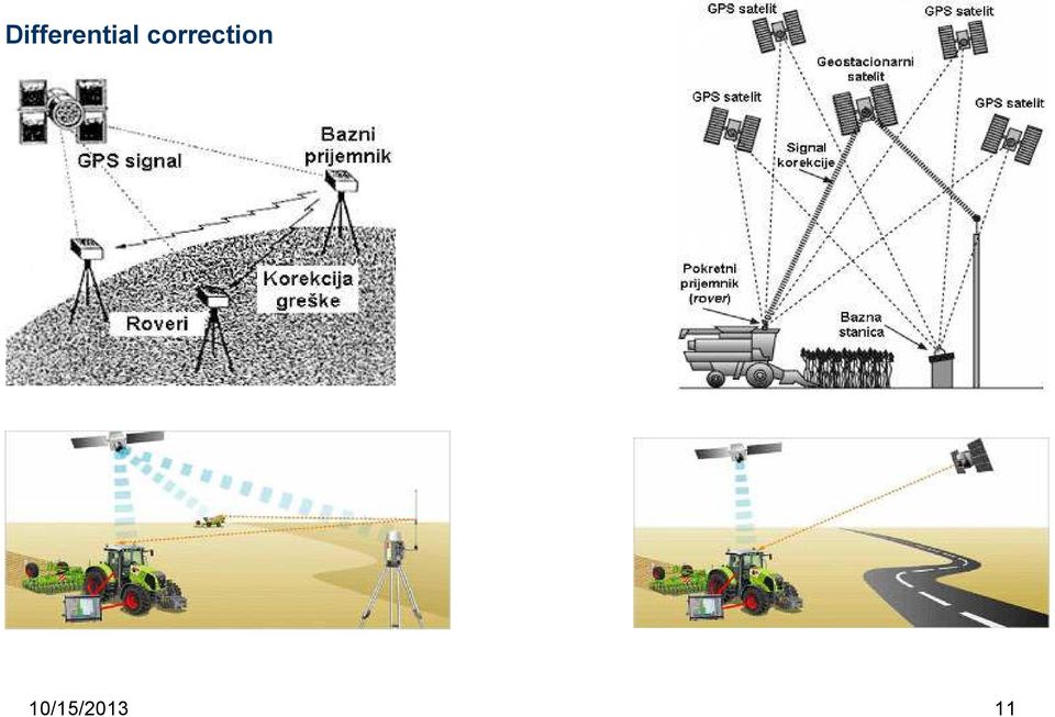
9 GPS error and correction defines the accuracy of positioning Accuracy m (even 100 m) at autonomous GPS (no correction), Accuracy under 25 mm with differentially corrected GPS-signal. Differential correction of positioning Based on the other GPS-receiver - BASE at known position. Any difference between the real and calculated latitude and longitude is recognized as differential error. 10/15/2013 9

10 10/15/

11 Differential correction 10/15/
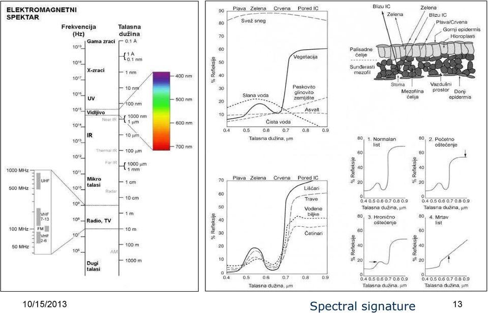
12 Remote sensing Remote sensing is the acquisition of information about an object or phenomenon without making physical contact with the object. Remote sensing relies on wave length of reflected EM radiation emitted from aircraft or satellites. 10/15/

13 10/15/2013 Spectral signature 13
14 BASIC PROCEDURES Data collection Yield monitoring and recording (automatic device on the harvester) Soil sampling Surveillance Data analysis Application 10/15/

15 MAPS BASICS You are nowhere without geography " Coordinate systems Rows and columns in ordinary table. Combination of the letter and number (coordinates) is exact address/position of the cell in the table. 10/15/

16 10/15/

17 Geographic Coordinate System - GCS Imagined network over the Earth surface, consisted of latitudes and longitudes. Latitudes rows of GCS horizontal circles parallel with Equator. North and south latitude distance from Equator zero latitude. Values (angle measures): 0 (Equator) 90 (North pole) -90 (South pole) Longitudes columns of GCS half circles from pole to pole. East and west longitude distance from Greenwich/zero meridian Values (angle measures): 0 (Greenwich) 180 (to east) -180 (to west) 10/15/
: 0 (Greenwich) 180 (to east) -180 (to")
18 10/15/

19 Formats of GCS coordinates DD format - decimal degrees degrees north latitude degrees west longitude DM format - degrees minutes degrees 33.6 minutes north latitude degrees 28.8 minutes west longitude DMS format - degrees minutes seconds degrees 33 minutes i 36 seconds north latitude degrees 28 minutes 48 seconds west longitude 10/15/

20 Scale The ratio of a distance on the map to the corresponding distance on the ground. Example: 1: cm at the map presents cm in field. Scale deals with details! Large scale map (up to 1: ) small region with many details Small scale map (1: and more) large region with less details. 10/15/
 small region with many details Small scale map (1:1.000.000 and more) large region with less details.")


21 1 : : : : : : /15/
22 Types op maps Reference map Some basic objects and features in Serbia. (larger cities, roads, rivers) Thematic map Presents values of some attribute. (number of men per 1000 women, by municipality) 10/15/
23 GIS (Geographic Informational System) Map and data base two components in GIS. Map and data base are functionally connected. Each poligon on the map has its row in the data base table. The rows contains the attributes of each poligon. Each field (column) in the data base table presents one attribute. SCSS0IL5 SOILNAME LCC PRIMELND LEAGFMLND CSR CORNYLD SOYBNYLD OATYLD WHEATYLD IA0048 KENYON 2E P P IA0071 COLO 2W P5 P IA0071 COLO 2W P5 P IA0048 KENYON 3E S P XS0381 KLINGER-MAXFIELD SICL 2W P2 P IA0066 DINSDALE 2E P P /15/ IA0066 DINSDALE 3E S P
24 GEOGRAPHIC INFORMATIONAL SYSTEM (GIS) What is GIS? Too simple electronic map. Exactly system of: computer, software, personnel, peripheral equipment and data. GIS system enables user to identify complex spatial relationships 10/15/
25 GIS map Set of overlaid layers. Each layer is digital presentation of one object - feature. One layer can contain thousands of features. Layers can be imagined as clean transparent sheets, overlaid one over another. 10/15/
26 Layers form a map 10/15/
27 GIS data base Each layer in the map has its own data base FID Shape WPT_NUMBERR WPT_NAME LATITUDE LONGITUDE DATE PHS98 BPHS98 OMS98 PS9S HKS98 CAS98 MGS98 CECS98 0 Point /5/ Point /5/ Point /5/ Point /5/ Point /5/ Point /5/ Point /5/ Point /5/ Point /5/ Each row in the table presents one feature in the map. Each column (field) in the table presents one attribute in the map. Attribute values of each feature are functionally connected with its feature in the map. GIS data base stores, organizes, searches and analyzes those data. 10/15/
28 DATA STRUCTURE Data format determines how will the data (attributes and locations) will be stored and presented in GIS. Attribute data are characteristics of the feature: tree diameter, number of grains in the corn cob ph value of the soil sample. Location data are coordinates for precise geographic positioning of that feature on the map. Base of those data is used for their storage, but in which format are those data presented? Vector and raster are two usual and well known data formats for presenting and storage. 10/15/
29 Vector data Vector layer contains: - points, - lines and - polygons. Any feature in the map can be identified by one of those three vector shapes. Object is physical entity in real world. Feature is vector presentation of of that entity on the map (point, line, polygon). 10/15/
30 Sources of vector data GPS - Global Positioning System Digitalization of paper maps Vector data from internet 10/15/
31 Raster data Rasters formats store the data in the mesh series of rows and collumns In there intersections are formed mesh cells. Each cell has location data and only one attribute value. Each value or interval of values is presented and visualized by different color data visualization. Mesh covers the whole surface of the area. vector raster 10/15/
32 Digital elevation model example of a raster mesh Attribute value of each mesh cell is altitude. 10/15/
33 Example from Google Earth: error in digitalization of the raster image of river banks and island in vector format lines Left layers list. Active layers: - Primary Database (raster) - Roads (vector lines) - Water Bodies (vector - lines) 10/15/
GPS Applications in Agriculture. Gary T. Roberson Agricultural Machinery Systems
 GPS Applications in Agriculture Gary T. Roberson Agricultural Machinery Systems What is a Positioning System? A position information system enables the user to determine absolute or relative location of
Remote Sensing Applications for Precision Agriculture
 Remote Sensing Applications for Precision Agriculture Farm Progress Show Chris J. Johannsen, Paul G. Carter and Larry L. Biehl Department of Agronomy and Laboratory for Applications of Remote Sensing (LARS)
SESSION 8: GEOGRAPHIC INFORMATION SYSTEMS AND MAP PROJECTIONS
 SESSION 8: GEOGRAPHIC INFORMATION SYSTEMS AND MAP PROJECTIONS KEY CONCEPTS: In this session we will look at: Geographic information systems and Map projections. Content that needs to be covered for examination
Learning about GPS and GIS
 Learning about GPS and GIS Standards 4.4 Understand geographic information systems (G.I.S.). B12.1 Understand common surveying techniques used in agriculture (e.g., leveling, land measurement, building
Motion & The Global Positioning System (GPS)
") Grade Level: K - 8 Subject: Motion Prep Time: < 10 minutes Duration: 30 minutes Objective: To learn how to analyze GPS data in order to track an object and derive its velocity from positions and times.
Grade Level: K - 8 Subject: Motion Prep Time: < 10 minutes Duration: 30 minutes Objective: To learn how to analyze GPS data in order to track an object and derive its velocity from positions and times.
Understanding Raster Data
 Introduction The following document is intended to provide a basic understanding of raster data. Raster data layers (commonly referred to as grids) are the essential data layers used in all tools developed
ADWR GIS Metadata Policy
 ADWR GIS Metadata Policy 1 PURPOSE OF POLICY.. 3 INTRODUCTION.... 4 What is metadata?... 4 Why is it important? 4 When to fill metadata...4 STANDARDS. 5 FGDC content standards for geospatial metadata...5
Introduction to GIS (Basics, Data, Analysis) & Case Studies. 13 th May 2004. Content. What is GIS?
 & Case Studies. 13 th May 2004. Content. What is GIS?") Introduction to GIS (Basics, Data, Analysis) & Case Studies 13 th May 2004 Content Introduction to GIS Data concepts Data input Analysis Applications selected examples What is GIS? Geographic Information
Introduction to GIS (Basics, Data, Analysis) & Case Studies 13 th May 2004 Content Introduction to GIS Data concepts Data input Analysis Applications selected examples What is GIS? Geographic Information
Introduction to GIS. http://libguides.mit.edu/gis
 Introduction to GIS http://libguides.mit.edu/gis 1 Overview What is GIS? Types of Data and Projections What can I do with GIS? Data Sources and Formats Software Data Management Tips 2 What is GIS? 3 Characteristics
GIS EXAM #2 QUERIES. Attribute queries only looks at the records in the attribute tables to some kind of
 GIS EXAM #2 QUERIES - Queries extracts particular records from a table or feature class for use; - Queries are an essential aspect of GIS analysis, and allows us to interrogate a dataset and look for patterns;
Natural Resources. Air and Water Resources
 Natural Resources Key Concepts Why is it important to manage air and water resources wisely? How can individuals help manage air and water resources wisely? Air and Water Resources What do you think? Read
WHAT IS GIS - AN INRODUCTION
 WHAT IS GIS - AN INRODUCTION GIS DEFINITION GIS is an acronym for: Geographic Information Systems Geographic This term is used because GIS tend to deal primarily with geographic or spatial features. Information
GIS: Geographic Information Systems A short introduction
 GIS: Geographic Information Systems A short introduction Outline The Center for Digital Scholarship What is GIS? Data types GIS software and analysis Campus GIS resources Center for Digital Scholarship
Chapter Contents Page No
 Chapter Contents Page No Preface Acknowledgement 1 Basics of Remote Sensing 1 1.1. Introduction 1 1.2. Definition of Remote Sensing 1 1.3. Principles of Remote Sensing 1 1.4. Various Stages in Remote Sensing
4 The Rhumb Line and the Great Circle in Navigation
 4 The Rhumb Line and the Great Circle in Navigation 4.1 Details on Great Circles In fig. GN 4.1 two Great Circle/Rhumb Line cases are shown, one in each hemisphere. In each case the shorter distance between
Remote Sensing and GIS Application In Change Detection Study In Urban Zone Using Multi Temporal Satellite
 Remote Sensing and GIS Application In Change Detection Study In Urban Zone Using Multi Temporal Satellite R.Manonmani, G.Mary Divya Suganya Institute of Remote Sensing, Anna University, Chennai 600 025
Raster to Vector Conversion for Overlay Analysis
 Raster to Vector Conversion for Overlay Analysis In some cases, it may be necessary to perform vector-based analyses on a raster data set, or vice versa. The types of analyses that can be performed on
Topographic Maps Practice Questions and Answers Revised October 2007
 Topographic Maps Practice Questions and Answers Revised October 2007 1. In the illustration shown below what navigational features are represented by A, B, and C? Note that A is a critical city in defining
Stage 4. Geography. Blackline Masters. By Karen Devine
 1 Devine Educational Consultancy Services Stage 4 Geography Blackline Masters By Karen Devine Updated January 2010 2 This book is intended for the exclusive use in NSW Secondary Schools. It is meant to
Raster Data Structures
 Raster Data Structures Tessellation of Geographical Space Geographical space can be tessellated into sets of connected discrete units, which completely cover a flat surface. The units can be in any reasonable
Sun Earth Relationships
 1 ESCI-61 Introduction to Photovoltaic Technology Sun Earth Relationships Ridha Hamidi, Ph.D. Spring (sun aims directly at equator) Winter (northern hemisphere tilts away from sun) 23.5 2 Solar radiation
Using Handheld GPS Units in the Field Overview
 Using Handheld GPS Units in the Field Overview Most recently revised 3/13/12 Equipment to have with you in the field PC laptop loaded with: - ESRI ArcMap 10 (get from Tufts GIS Support) - DNR Garmin (freeware
Earth-Sun Relationships. The Reasons for the Seasons
 Earth-Sun Relationships The Reasons for the Seasons Solar Radiation The earth intercepts less than one two-billionth of the energy given off by the sun. However, the radiation is sufficient to provide
Remote Sensing, GPS and GIS Technique to Produce a Bathymetric Map
 Remote Sensing, GPS and GIS Technique to Produce a Bathymetric Map Mark Schnur EES 5053 Remote Sensing Fall 2007 University of Texas at San Antonio, Department of Earth and Environmental Science, San Antonio,
The Map Grid of Australia 1994 A Simplified Computational Manual
 The Map Grid of Australia 1994 A Simplified Computational Manual The Map Grid of Australia 1994 A Simplified Computational Manual 'What's the good of Mercator's North Poles and Equators, Tropics, Zones
Improving Data Mining of Multi-dimension Objects Using a Hybrid Database and Visualization System
 Improving Data Mining of Multi-dimension Objects Using a Hybrid Database and Visualization System Yan Xia, Anthony Tung Shuen Ho School of Electrical and Electronic Engineering Nanyang Technological University,
Digital Remote Sensing Data Processing Digital Remote Sensing Data Processing and Analysis: An Introduction and Analysis: An Introduction
 Digital Remote Sensing Data Processing Digital Remote Sensing Data Processing and Analysis: An Introduction and Analysis: An Introduction Content Remote sensing data Spatial, spectral, radiometric and
Accuracy Assessment of Land Use Land Cover Classification using Google Earth
 American Journal of Environmental Protection 25; 4(4): 9-98 Published online July 2, 25 (http://www.sciencepublishinggroup.com/j/ajep) doi:.648/j.ajep.2544.4 ISSN: 228-568 (Print); ISSN: 228-5699 (Online)
Data Visualization Techniques and Practices Introduction to GIS Technology
 Data Visualization Techniques and Practices Introduction to GIS Technology Michael Greene Advanced Analytics & Modeling, Deloitte Consulting LLP March 16 th, 2010 Antitrust Notice The Casualty Actuarial
Grades 3-5. Benchmark A: Use map elements or coordinates to locate physical and human features of North America.
 Grades 3-5 Students use knowledge of geographic locations, patterns and processes to show the interrelationship between the physical environment and human activity, and to explain the interactions that
Model Virginia Map Accuracy Standards Guideline
 Commonwealth of Virginia Model Virginia Map Accuracy Standards Guideline Virginia Information Technologies Agency (VITA) Publication Version Control Publication Version Control: It is the user's responsibility
What is GIS? Geographic Information Systems. Introduction to ArcGIS. GIS Maps Contain Layers. What Can You Do With GIS? Layers Can Contain Features
 What is GIS? Geographic Information Systems Introduction to ArcGIS A database system in which the organizing principle is explicitly SPATIAL For CPSC 178 Visualization: Data, Pixels, and Ideas. What Can
Digital Cadastral Maps in Land Information Systems
 LIBER QUARTERLY, ISSN 1435-5205 LIBER 1999. All rights reserved K.G. Saur, Munich. Printed in Germany Digital Cadastral Maps in Land Information Systems by PIOTR CICHOCINSKI ABSTRACT This paper presents
Cultivating Agricultural Information Management System Using GIS Technology
 Hitachi Review Vol. 58 (2009), No. 6 265 Cultivating Agricultural Information Management System Using GIS Technology Improving Agricultural Efficiency through Information Technology Osamu Nishiguchi Noriko
Implementation Planning
 Implementation Planning presented by: Tim Haithcoat University of Missouri Columbia 1 What is included in a strategic plan? Scale - is this departmental or enterprise-wide? Is this a centralized or distributed
Lecture 2. Map Projections and GIS Coordinate Systems. Tomislav Sapic GIS Technologist Faculty of Natural Resources Management Lakehead University
 Lecture 2 Map Projections and GIS Coordinate Systems Tomislav Sapic GIS Technologist Faculty of Natural Resources Management Lakehead University Map Projections Map projections are mathematical formulas
Image Analysis CHAPTER 16 16.1 ANALYSIS PROCEDURES
 CHAPTER 16 Image Analysis 16.1 ANALYSIS PROCEDURES Studies for various disciplines require different technical approaches, but there is a generalized pattern for geology, soils, range, wetlands, archeology,
Representing Geography
 3 Representing Geography OVERVIEW This chapter introduces the concept of representation, or the construction of a digital model of some aspect of the Earth s surface. The geographic world is extremely
APPLY EXCEL VBA TO TERRAIN VISUALIZATION
 APPLY EXCEL VBA TO TERRAIN VISUALIZATION 1 2 Chih-Chung Lin( ), Yen-Ling Lin ( ) 1 Secretariat, National Changhua University of Education. General Education Center, Chienkuo Technology University 2 Dept.
The farm: Placed in the middle of Sealand 250 hektar 5000 pigs 30-110 kg produced Soiltype: JB 6
 The farm: Placed in the middle of Sealand 250 hektar 5000 pigs 30-110 kg produced Soiltype: JB 6 (app. 14% clay, 14 silt, 45% fine sand, 27% sand) The principles of Conservation Agriculture (CA): - Minimum
Modern Agricultural Digital Management Network Information System of Heilongjiang Reclamation Area Farm
 Modern Agricultural Digital Management Network Information System of Heilongjiang Reclamation Area Farm Xi Wang, Chun Wang, Wei Dong Zhuang, and Hui Yang Engineering Collage, Heilongjiang August the First
Newton s Law of Gravity
 Gravitational Potential Energy On Earth, depends on: object s mass (m) strength of gravity (g) distance object could potentially fall Gravitational Potential Energy In space, an object or gas cloud has
ENERGY IN FERTILIZER AND PESTICIDE PRODUCTION AND USE
 Farm Energy IQ Conserving Energy in Nutrient Use and Pest Control INTRODUCTION Fertilizers and pesticides are the most widely used sources of nutrients and pest control, respectively. Fertilizer and pesticides
American-Eurasian Journal of Sustainable Agriculture
 Copyright 2015, American-Eurasian Network for Scientific Information publisher American-Eurasian Journal of Sustainable Agriculture ISSN: 1995-0748 JOURNAL home page: http://www.aensiweb.com/aejsa 2015
World Map Lesson 4 - The Global Grid System - Grade 6+
 World Map Lesson 4 - The Global Grid System - Grade 6+ Activity Goal To use the global grid system of latitude and longitude to find specific locations on a world map. Materials Needed: A pencil, a ruler,
Seasonal & Daily Temperatures. Seasons & Sun's Distance. Solstice & Equinox. Seasons & Solar Intensity
 Seasonal & Daily Temperatures Seasons & Sun's Distance The role of Earth's tilt, revolution, & rotation in causing spatial, seasonal, & daily temperature variations Please read Chapter 3 in Ahrens Figure
Pre and post-visit activities - Navigating by the stars
 Pre and post-visit activities - Navigating by the stars Vocabulary List Adult Education at Scienceworks Pre-visit Activity 1: What is longitude and latitude? Activity 2: Using the Southern Cross to find
The Basics of Navigation
 The Basics of Navigation Knowledge of map reading and the use of the compass is an indispensable skill of bushcraft. Without this skill, a walker is a passenger and mere follower on a trip. To become a
Answer Keys to Unit Tests
 Reading Geography Series Answer Keys to Unit Tests Unit 1 The Five Themes of Geography Unit 2 Patterns in Physical Geography Unit 3 Natural Resources 7 Portage & Main Press Unit Test for The Five Themes
2. Orbits. FER-Zagreb, Satellite communication systems 2011/12
 2. Orbits Topics Orbit types Kepler and Newton laws Coverage area Influence of Earth 1 Orbit types According to inclination angle Equatorial Polar Inclinational orbit According to shape Circular orbit
Unit A: General Agricultural Machinery. Lesson 1: Machinery and Equipment
 Unit A: General Agricultural Machinery Lesson 1: Machinery and Equipment Student Learning Objectives: Instruction in this lesson should result in students achieving the following objectives: 1. Explain
Measuring the Earth Using a GPS M. Scott Wilkerson & M. Beth Wilkerson, DePauw University, May 10, 2007
 Measuring the Earth Using a GPS M. Scott Wilkerson & M. Beth Wilkerson, DePauw University, May 10, 2007 Modified from: Kerski, J.J., 2007, Measuring the Earth s Circumference with GPS, Copyright ESRI,
High Resolution RF Analysis: The Benefits of Lidar Terrain & Clutter Datasets
 0 High Resolution RF Analysis: The Benefits of Lidar Terrain & Clutter Datasets January 15, 2014 Martin Rais 1 High Resolution Terrain & Clutter Datasets: Why Lidar? There are myriad methods, techniques
From Satellite to Silo: The impact of EGNOS on Precision Farming
 From Satellite to Silo: The impact of EGNOS on Precision Farming Dr Sally Basker, Booz Allen Hamilton Dr Javier Ventura-Traveset, ESA Toulouse Mr Giorgio Solari, ESA Brussels Mr Richard Reed, LH Agro (UK)
Determining the Use of Technology in World Food and Fiber Production
 Lesson A8 1 Determining the Use of Technology in World Food and Fiber Production Unit A. Mechanical Systems and Technology Problem Area 8. Technology Systems Lesson 1. Determining the Use of Technology
PHY121 #8 Midterm I 3.06.2013
 PHY11 #8 Midterm I 3.06.013 AP Physics- Newton s Laws AP Exam Multiple Choice Questions #1 #4 1. When the frictionless system shown above is accelerated by an applied force of magnitude F, the tension
Environmental Remote Sensing GEOG 2021
 Environmental Remote Sensing GEOG 2021 Lecture 4 Image classification 2 Purpose categorising data data abstraction / simplification data interpretation mapping for land cover mapping use land cover class
FCC Management Software Field Manager PRO 360
 FCC Management Software Field Manager PRO 360 Mapping Guide Setup Defining the main farm address To define the main farm address (internet connection required): 1. Click on the Setup menu. 2. Select Fields.
Worksheet to Review Vector and Scalar Properties
 Worksheet to Review Vector and Scalar Properties 1. Differentiate between vectors and scalar quantities 2. Know what is being requested when the question asks for the magnitude of a quantity 3. Define
GEOGRAPHIC INFORMATION SYSTEMS CERTIFICATION
 GEOGRAPHIC INFORMATION SYSTEMS CERTIFICATION GIS Syllabus - Version 1.2 January 2007 Copyright AICA-CEPIS 2009 1 Version 1 January 2007 GIS Certification Programme 1. Target The GIS certification is aimed
A GIS helps you answer questions and solve problems by looking at your data in a way that is quickly understood and easily shared.
 A Geographic Information System (GIS) integrates hardware, software, and data for capturing, managing, analyzing, and displaying all forms of geographically referenced information. GIS allows us to view,
11.1. Objectives. Component Form of a Vector. Component Form of a Vector. Component Form of a Vector. Vectors and the Geometry of Space
 11 Vectors and the Geometry of Space 11.1 Vectors in the Plane Copyright Cengage Learning. All rights reserved. Copyright Cengage Learning. All rights reserved. 2 Objectives! Write the component form of
Navigation: Latitude and Longitude
 Sextants and Chronometers Help Sailors Find Their Position at Sea Latitude lines run horizontally across the globe and are used to measure distances north and south of the equator. Sailors used a sextant
EDMONDS COMMUNITY COLLEGE ASTRONOMY 100 Winter Quarter 2007 Sample Test # 1
 Instructor: L. M. Khandro EDMONDS COMMUNITY COLLEGE ASTRONOMY 100 Winter Quarter 2007 Sample Test # 1 1. An arc second is a measure of a. time interval between oscillations of a standard clock b. time
CHAPTER 2 HYDRAULICS OF SEWERS
 CHAPTER 2 HYDRAULICS OF SEWERS SANITARY SEWERS The hydraulic design procedure for sewers requires: 1. Determination of Sewer System Type 2. Determination of Design Flow 3. Selection of Pipe Size 4. Determination
Name: PLSOIL 105 & 106 First Hour Exam February 27, 2012. Part A. Place answers on bubble sheet. 2 pts. each.
 Name: PLSOIL 105 & 106 First Hour Exam February 27, 2012 Part A. Place answers on bubble sheet. 2 pts. each. 1. A soil with 15% clay and 20% sand would belong to what textural class? A. Clay C. Loamy sand
What is GIS? Why Geography?
 Geographic Information System (GIS), What is GIS? contributed by the Spatial Data Management Division, secretariat of the Land Information Council of Jamaica (LICJ), Ministry of Agriculture. Contact Ms.
Practical, Easy-to-Use, Free GIS and Remote Sensing Tools for Resource Management
 Practical, Easy-to-Use, Free GIS and Remote Sensing Tools for Resource Management Andrew Lister Research Forester 11 Campus Blvd, Ste. 200 Newtown Square, PA 19073 alister@fs.fed.us Abstract: Geographic
Interaction of Energy and Matter Gravity Measurement: Using Doppler Shifts to Measure Mass Concentration TEACHER GUIDE
 Interaction of Energy and Matter Gravity Measurement: Using Doppler Shifts to Measure Mass Concentration TEACHER GUIDE EMR and the Dawn Mission Electromagnetic radiation (EMR) will play a major role in
MEASUREMENT. Historical records indicate that the first units of length were based on people s hands, feet and arms. The measurements were:
 MEASUREMENT Introduction: People created systems of measurement to address practical problems such as finding the distance between two places, finding the length, width or height of a building, finding
Experiment 5: Magnetic Fields of a Bar Magnet and of the Earth
 MASSACHUSETTS INSTITUTE OF TECHNOLOGY Department of Physics 8.02 Spring 2005 Experiment 5: Magnetic Fields of a Bar Magnet and of the Earth OBJECTIVES 1. To examine the magnetic field associated with a
Seventh Grade Science Content Standards and Objectives
 Seventh Grade Science Content Standards and Objectives Standard 2: Nature of Science Students will demonstrate an understanding of the history of science and the evolvement of scientific knowledge. SC.S.7.1
Using Technology and Big Data to Improve Profits. Matt Darr, Agricultural & Biosystems Engineering
 Using Technology and Big Data to Improve Profits Matt Darr, Agricultural & Biosystems Engineering 2015 THE YEAR OF BIG DATA Why the New Emphasis on Data Today? Autosteering and swath control technology
APPENDIX D: SOLAR RADIATION
 APPENDIX D: SOLAR RADIATION The sun is the source of most energy on the earth and is a primary factor in determining the thermal environment of a locality. It is important for engineers to have a working
EPSG. Coordinate Reference System Definition - Recommended Practice. Guidance Note Number 5
 European Petroleum Survey Group EPSG Guidance Note Number 5 Coordinate Reference System Definition - Recommended Practice Revision history: Version Date Amendments 1.0 April 1997 First release. 1.1 June
Connected Farm Field Services. Dan Rooney InfoAg Conference, July 30, 2014
 Connected Farm Field Services Dan Rooney InfoAg Conference, July 30, 2014 What is Connected Farm? Connected Farm is an integrated operations management solution that combines industry-leading hardware,
CHAPTER 9 SURVEYING TERMS AND ABBREVIATIONS
 CHAPTER 9 SURVEYING TERMS AND ABBREVIATIONS Surveying Terms 9-2 Standard Abbreviations 9-6 9-1 A) SURVEYING TERMS Accuracy - The degree of conformity with a standard, or the degree of perfection attained
OBJECTIVES. Identify the means by which latitude and longitude were created and the science upon which they are based.
 Name: Key OBJECTIVES Correctly define: isolines, gradient, topographic map, contour interval, hachured lines, profile, latitude, longitude, hydrosphere, lithosphere, atmosphere, elevation, model EARTH
From Whitehall to orbit and back again: using space in government
 From Whitehall to orbit and back again: using space in government 18 th June 2014 Bristol 25 th June 2014 Liverpool 3 rd July 2014 -Newcastle Space for Smarter Government Programme (ssgp@sa.catapult.org.uk)
6 th Grade Vocabulary-ALL CAMPUSES
 6 th Grade Vocabulary-ALL CAMPUSES 6.1 History. The student understands that historical events influence contemporary events. (B) analyze the historical background of the United States to evaluate relationships
Geographical Information Systems (GIS) and Economics 1
 and Economics 1") Geographical Information Systems (GIS) and Economics 1 Henry G. Overman (London School of Economics) 5 th January 2006 Abstract: Geographical Information Systems (GIS) are used for inputting, storing,
Geographical Information Systems (GIS) and Economics 1 Henry G. Overman (London School of Economics) 5 th January 2006 Abstract: Geographical Information Systems (GIS) are used for inputting, storing,
Coordinate Systems. Orbits and Rotation
 Coordinate Systems Orbits and Rotation Earth orbit. The earth s orbit around the sun is nearly circular but not quite. It s actually an ellipse whose average distance from the sun is one AU (150 million
Fertility Guidelines for Hops in the Northeast Dr. Heather Darby, University of Vermont Extension Agronomist
 Fertility Guidelines for Hops in the Northeast Dr. Heather Darby, University of Vermont Extension Agronomist The increasing acreage of hops in the Northeast has prompted the need for fertility guidelines
NRI Soil Monitoring Network
 NRI Soil Monitoring Network Stephen Ogle, Keith Paustian, Karolien Denef, Ram Gurung, F. Jay Breidt Colorado State University Mike Sucik and Daryl Lund USDA Natural Resources Conservation Service Goals
Overview. What is EMR? Electromagnetic Radiation (EMR) LA502 Special Studies Remote Sensing
 LA502 Special Studies Remote Sensing") LA502 Special Studies Remote Sensing Electromagnetic Radiation (EMR) Dr. Ragab Khalil Department of Landscape Architecture Faculty of Environmental Design King AbdulAziz University Room 103 Overview What
LA502 Special Studies Remote Sensing Electromagnetic Radiation (EMR) Dr. Ragab Khalil Department of Landscape Architecture Faculty of Environmental Design King AbdulAziz University Room 103 Overview What
Tutorial 8 Raster Data Analysis
 Objectives Tutorial 8 Raster Data Analysis This tutorial is designed to introduce you to a basic set of raster-based analyses including: 1. Displaying Digital Elevation Model (DEM) 2. Slope calculations
Spatial Distribution of Precision Farming Technologies in Tennessee. Burton C. English Roland K. Roberts David E. Sleigh
 Spatial Distribution of Precision Farming Technologies in Tennessee Burton C. English Roland K. Roberts David E. Sleigh Research Report 00-08 February 2000 Department of Agricultural Economics and Rural
Map Patterns and Finding the Strike and Dip from a Mapped Outcrop of a Planar Surface
 Map Patterns and Finding the Strike and Dip from a Mapped Outcrop of a Planar Surface Topographic maps represent the complex curves of earth s surface with contour lines that represent the intersection
Assessment of Groundwater Vulnerability to Landfill Leachate Induced Arsenic Contamination in Maine, US - Intro GIS Term Project Final Report
 Assessment of Groundwater Vulnerability to Landfill Leachate Induced Arsenic Contamination in Maine, US - Intro GIS Term Project Final Report Introduction Li Wang Dept. of Civil & Environmental Engineering
Institute of Natural Resources Departament of General Geology and Land use planning Work with a MAPS
 Institute of Natural Resources Departament of General Geology and Land use planning Work with a MAPS Lecturers: Berchuk V.Y. Gutareva N.Y. Contents: 1. Qgis; 2. General information; 3. Qgis desktop; 4.
Math 215 Project (25 pts) : Using Linear Algebra to solve GPS problem
 : Using Linear Algebra to solve GPS problem") Due Thursday March 1, 2012 NAME(S): Math 215 Project (25 pts) : Using Linear Algebra to solve GPS problem 0.1 Introduction The age old question, Where in the world am I? can easily be solved nowadays by
Due Thursday March 1, 2012 NAME(S): Math 215 Project (25 pts) : Using Linear Algebra to solve GPS problem 0.1 Introduction The age old question, Where in the world am I? can easily be solved nowadays by
Basic Coordinates & Seasons Student Guide
 Name: Basic Coordinates & Seasons Student Guide There are three main sections to this module: terrestrial coordinates, celestial equatorial coordinates, and understanding how the ecliptic is related to
Introduction: Growth analysis and crop dry matter accumulation
 PBIO*3110 Crop Physiology Lecture #2 Fall Semester 2008 Lecture Notes for Tuesday 9 September How is plant productivity measured? Introduction: Growth analysis and crop dry matter accumulation Learning
Introduction to Geography
 High School Unit: 1 Lesson: 1 Suggested Duration: 3 days Introduction to Lesson Synopsis: The purpose of this lesson is to introduce students to geography and geography terminology, to teach students about
APLS 2011. GIS Data: Classification, Potential Misuse, and Practical Limitations
 APLS 2011 GIS Data: Classification, Potential Misuse, and Practical Limitations GIS Data: Classification, Potential Misuse, and Practical Limitations Goals & Objectives Develop an easy to use geospatial
Cookbook 23 September 2013 GIS Analysis Part 1 - A GIS is NOT a Map!
 Cookbook 23 September 2013 GIS Analysis Part 1 - A GIS is NOT a Map! Overview 1. A GIS is NOT a Map! 2. How does a GIS handle its data? Data Formats! GARP 0344 (Fall 2013) Page 1 Dr. Carsten Braun 1) A
How can information technology play a role in primary industries climate resilience?
 Manage Data. Harvest Information. How can information technology play a role in primary industries climate resilience? CHALLENGES FOR WORLD AGRICULTURE 9 Billion people on earth by 2040 Up to 40% of food
The Status of Geospatial Information Management in China
 The Status of Geospatial Information Management in China Submitted by the National Administration of Surveying, Mapping and Geoinformation of China 1. Administration System The National Administration
A quick overview of geographic information systems (GIS) Uwe Deichmann, DECRG <udeichmann@worldbank.org>
 Uwe Deichmann, DECRG <udeichmann@worldbank.org>") A quick overview of geographic information systems (GIS) Uwe Deichmann, DECRG Why is GIS important? A very large share of all types of information has a spatial component ( 80
A quick overview of geographic information systems (GIS) Uwe Deichmann, DECRG Why is GIS important? A very large share of all types of information has a spatial component ( 80
compass Encyclopedic Entry
 This website would like to remind you: Your browser (Apple Safari 7) is out of date. Update your browser for more security, comfort and the best experience on this site. Encyclopedic Entry compass For