VALIDATION OF THE SUNY SATELLITE MODEL IN A METEOSAT ENVIRONMENT
|
|
|
- Annabella Lynch
- 9 years ago
- Views:
Transcription
1 VALIDATION OF THE SUNY SATELLITE MODEL IN A METEOSAT ENVIRONMENT Richard Perez ASRC, 251 Fuller Rd Albany, NY, [email protected],edu Jim Schlemmer ASRC [email protected],edu Shannon Cowlin NREL [email protected] Ray George NREL [email protected] David Renne NREL, 1617 Cole Blvd. Golden, CO [email protected] Bibek Bandyopadhyay Solar Energy Centre New Delhi, India [email protected] ABSTRACT The paper presents a validation of the SUNY satellite-toirradiance model against four ground-truth stations from the Indian solar radiation network located in and around the province of Rajasthan, India. The SUNY model had initially been developed and tested to process US weather satellite data from the GOES series and has been used as part of the production of the US National Solar Resource Data Base (NSRDB). Here the model is applied to processes data from the European weather satellites Meteosat 5 and INTODUCTION The SUNY satellite model [1, 2] was developed to produce surface irradiances from the visible channel of the GOES weather satellites series -- the GOES satellites include two operational units located respectively at the longitudes of the American East Coast (75 o West) and West Coast (135 o West) The model has been extensively validated for the western hemisphere [e.g., 3] and was recently used to produce the high resolution data distributed as part of the National Solar Radiation Data Base [3]. In this paper we evaluate the model s performance with another set of satellites: the European Meteosat 5 and 7 satellites which are positioned at the longitude of central Asia (57.5 o East). This evaluation was undertaken as part of the production of high resolution irradiance maps for Northwestern India as an activity of the New Technology and Renewable Energy Working Group under the US India Energy Dialogue [4]. In addition to markedly different climatic conditions, there are small but significant differences between the treatment of GOES and Meteosat images which can impact the accuracy of the model. The GOES visible channel data used in the US model are pre-processed for better visual appearance by application of a square-root filter to image pixel counts. The treatment of the Meteosat archives was not known and had to be inferred from the data signature with respect to solar geometry; the analysis revealed that, in all likelihood, no filter had been applied. Another pertinent difference between the two sets of satellites is a wider visible channel spectral range for the European satellite ( μ, against μ for GOES). 2. EXPERIMENTAL DATA 2.1 Satellite Data Hourly visible channel frames covering western India from December 2002 through January 31, 2007 were subsampled onto a 0.1 o x 0.1 o latitude-longitude grid analogous to the

2 US operational grid. Data are from Meteosat 5 up to January 25, 2007, and from Meteosat 7 thereafter. 2.2 Ancillary Model Input Data The gridded ancillary data used by the SUNY model include: Monthly climatological broad-band Aerosol optical Depth (AOD) Monthly climatological precipitable water Monthly climatological ozone Terrain elevation Daily Snow Cover The first two inputs, AOD and precipitable water, are used to parameterize turbidity (AOD being the more influential of the two). AOD was obtained from the Aqua satellite s MODIS [5] sensor modeled via GOCART [6]. 2.3 Ground Truth Data Hourly solar radiation measurements from the Indian Meteorological Department network [7] were received for the year 2006 for four western India stations: Bhopal, Jaipur, Delhi and Jaisalmer (see locations in Fig. 5 and 6). GHI is measured at all stations, but DNI was only recorded in Jaipur and Bhopal during the considered period. Data availability was quasi complete (>85%) for all sites, except Delhi where over 70% of the GHI data were missing. Instrumentation consists of thermopile pyranometers and pyrheliometers. 3. VALIDATION Model performance is summarized in Table 1 where overall Root Mean Square and Mean Bias Errors (RMSE and MBE) are presented. The results indicate that the model works well for GHI prediction. The GHI scatter plots shown in Fig.1 visually confirm that performance is on par with the North American sites previously used for model evaluation [2]. The model tends to overestimate slightly (2-3%) -- this slight overestimation could be remedied by moderately increasing turbidity. The positive MBE is larger in Delhi, but evidence indicates that this may be traceable to instrument calibration: see for instance the comparison between Jaipur and Delhi for time coincident GHI data in Figure 2 (left). The clean, systematic departure from the one-to-one line expected between the two sites is more symptomatic of a calibration difference than weather differences; in fact a simple linear adjustment suffices to bring the satellite model to agreement with the Delhi data (see Figure 2, right). For DNI, both the results in table 1 and the scatter plots in Figure 3 show a strong model overestimation: +100% in Bhopal, and +80% in Jaipur. Is this overestimation real and reflective of a massively underestimated turbidity, or simply reflective of measurement uncertainty? The turbidity argument is difficult to defend, because increasing AOD so as to eliminate the DNI bias results in a considerable underestimation of GHI; indeed the GHI-DNI relationship observed from measurements in both Jaipur and Bhopal is markedly different from that observed, understood and validated in the western hemisphere and Europe,). This unknown difference between the Indian sites and the U.S. site is illustrated Figure 4 where the Kb-Kt relationship for Jaipur and a US site (Penn State) are intercompared. At this time, given the data available to us, it is not possible to put this question to rest. Its answer will first require a controlled in-situ experiment comparing ongoing ground measurements with referenced standards to first ascertain the quality of the measured data, and then as appropriate, refine the GHI-DNI relationships to reflect a different type of environment. TABLE 1 Model Validation Summary BHOPAL JAIPUR DHELI JAISALMER GHI DNI GHI DNI GHI DNI GHI DNI MEAN na 246 na yearly data recovery 91% 91% 99% 99% 28% na 86% na MBE na 6 na RMSE na 46 na MBE% 3.5% 107.2% 3.3% 81.1% 10.7% na 2.5% na RMSE% 24% 198% 27% 173% 30% na 19% na
. AOD was obtained from the Aqua satellite s MODIS [5] sensor modeled via GOCART [6]. 2.")
3 \ Figure 1: Satellite vs. measured GHI Figure 2: Comparing Delhi and Jaipur GHI (left), and satellite vs. ground data in Delhi using a single calibration correction factor (right)

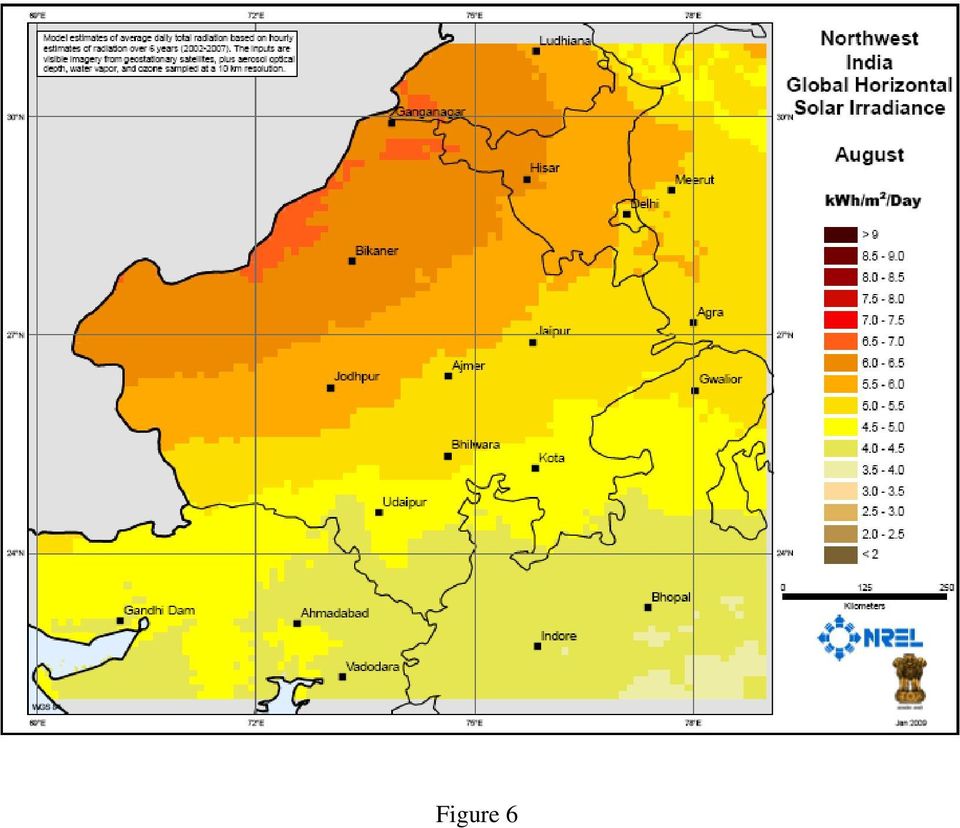
4 Figure 3: Satellite-derived vs. measured DNI Figure 4: Comparing Kb-Kt relationship observed from the Indian network to a typical relationship in the US 4. RAJAHSTAN SOLAR RESOURCE The solar resource data from this project are available through NREL [8]. With the DNI caveat discussed above, and the confidence acquired in GHI modeling, we were able to produce six years of high resolution irradiances for the Rajasthan. Examples of this effort are shown in Figs. 5 and 6 where the mean daily GHI for August and February are compared, showing a very intense monsoon effect and a complete reversal of the province s north-south gradient in summer. 5. CONCLUSION This study indicates that SUNY model works adequately with Meteosat data. The performance of the GHI model is comparable to that observed in the western hemisphere.

5 A big unknown remains with DNI modeling which will require further investigation. Is this a measurement issue? or does the radiative environment of Western India characterized by high turbidity from high dust content -- warrant a revision of well known GHI-to-DNI models? 6. ACKNOWLEDGEMENT This work was done under NREL Subcontract No. AEK Thanks to Steve Wilcox for insightful comments. 7. REFERENCE 1. Perez R., P. Ineichen, K. Moore, M. Kmiecik, C. Chain, R. George and F. Vignola, (2002): A New Operational Satellite-to-Irradiance Model. Solar Energy 73, 5, pp Perez R., P. Ineichen, M. Kmiecik, K. Moore, R. George and D. Renné, (2004): Producing satellitederived irradiances in complex arid terrain. Solar Energy 77, 4, Myers, D., S. Wilcox, W. Marion, R. George, M. Anderberg, Broadband Model Performance for an Updated National Solar Radiation Data Base in the United States of America, Proc. Solar World Congress, International Solar Energy Society, Yu H., et al., Annual cycle of global distributions of aerosol optical depth from integration of MODIS retrievals and GOCART model simulations. J. Geophys. Res., 108D, 4128, doi: /2002jd002717, Chin M., Tropospheric aerosol optical thickness from the GOCART model and comparisons with satellite and sun photometer measurements. J. Atmos. Sci., 59, , Solar Radiation Handbook (2008): Typical Climatic Data for Selected Radiation Stations. A joint Project of Solar Energy Centre, MNRE Indian Metrological Department 8. Figure 5
: A New Operational Satellite-to-Irradiance Model. Solar Energy 73, 5, pp. 307-317 2. Perez R., P. Ineichen, M. Kmiecik, K. Moore, R. George and D.")
6 Figure 6
REDUCING UNCERTAINTY IN SOLAR ENERGY ESTIMATES
 REDUCING UNCERTAINTY IN SOLAR ENERGY ESTIMATES Mitigating Energy Risk through On-Site Monitoring Marie Schnitzer, Vice President of Consulting Services Christopher Thuman, Senior Meteorologist Peter Johnson,
Vaisala 3TIER Services Global Solar Dataset / Methodology and Validation
 ENERGY Vaisala 3TIER Services Global Solar Dataset / Methodology and Validation Global Horizontal Irradiance 70 Introduction Solar energy production is directly correlated to the amount of radiation received
Progress on an Updated National Solar Radiation Data Base
 March 2004 NREL/CP-560-36038 Progress on an Updated National Solar Radiation Data Base Preprint S. Wilcox, M. Anderberg, R. George, W. Marion, D. Myers, and D. Renne National Renewable Energy Laboratory
VALIDATION OF SHORT AND MEDIUM TERM OPERATIONAL SOLAR RADIATION FORECASTS IN THE US
 VALIDATION OF SHORT AND MEDIUM TERM OPERATIONAL SOLAR RADIATION FORECASTS IN THE US Richard Perez, Sergey Kivalov, James Schlemmer, Karl Hemker Jr., ASRC, University at Albany David Renné National Renewable
Solar Radiation Measurement. Bruce W Forgan, WMO RAV Metrology Workshop, Melbourne, Novemberr 2011
 Solar Radiation Measurement Bruce W Forgan, WMO RAV Metrology Workshop, Melbourne, Novemberr 2011 Why Do We Need Data on Solar Energy? Global Climate System Climate Energy Balance Solar Exposure and Irradiance
EVALUATION OF NUMERICAL WEATHER PREDICTION SOLAR IRRADIANCE FORECASTS IN THE US
 EVALUATION OF NUMERICAL WEATHER PREDICTION SOLAR IRRADIANCE FORECASTS IN THE US Richard Perez ASRC, Albany, NY, [email protected],edu Mark Beauharnois ASRC, Albany, NY [email protected],edu Karl Hemker,
EVALUATING SOLAR ENERGY PLANTS TO SUPPORT INVESTMENT DECISIONS
 EVALUATING SOLAR ENERGY PLANTS TO SUPPORT INVESTMENT DECISIONS Author Marie Schnitzer Director of Solar Services Published for AWS Truewind October 2009 Republished for AWS Truepower: AWS Truepower, LLC
Solar Input Data for PV Energy Modeling
 June 2012 Solar Input Data for PV Energy Modeling Marie Schnitzer, Christopher Thuman, Peter Johnson Albany New York, USA Barcelona Spain Bangalore India Company Snapshot Established in 1983; nearly 30
Meteorological Forecasting of DNI, clouds and aerosols
 Meteorological Forecasting of DNI, clouds and aerosols DNICast 1st End-User Workshop, Madrid, 2014-05-07 Heiner Körnich (SMHI), Jan Remund (Meteotest), Marion Schroedter-Homscheidt (DLR) Overview What
by Ben Bourne 2009 PVSim and Solar Energy System Performance Modeling
 by Ben Bourne 2009 PVSim and Solar Energy System Performance Modeling EXECUTIVE SUMMARY SunPower Corporation develops and maintains a custom photovoltaic (PV) simulation tool called SunPower PVSim for
Solar Irradiance Forecasting Using Multi-layer Cloud Tracking and Numerical Weather Prediction
 Solar Irradiance Forecasting Using Multi-layer Cloud Tracking and Numerical Weather Prediction Jin Xu, Shinjae Yoo, Dantong Yu, Dong Huang, John Heiser, Paul Kalb Solar Energy Abundant, clean, and secure
User Perspectives on Project Feasibility Data
 User Perspectives on Project Feasibility Data Marcel Šúri Tomáš Cebecauer GeoModel Solar s.r.o., Bratislava, Slovakia [email protected] http://geomodelsolar.eu http://solargis.info Solar Resources
Solarstromprognosen für Übertragungsnetzbetreiber
 Solarstromprognosen für Übertragungsnetzbetreiber Elke Lorenz, Jan Kühnert, Annette Hammer, Detlev Heienmann Universität Oldenburg 1 Outline grid integration of photovoltaic power (PV) in Germany overview
T.A. Tarasova, and C.A.Nobre
 SEASONAL VARIATIONS OF SURFACE SOLAR IRRADIANCES UNDER CLEAR-SKIES AND CLOUD COVER OBTAINED FROM LONG-TERM SOLAR RADIATION MEASUREMENTS IN THE RONDONIA REGION OF BRAZIL T.A. Tarasova, and C.A.Nobre Centro
Influence of Solar Radiation Models in the Calibration of Building Simulation Models
 Influence of Solar Radiation Models in the Calibration of Building Simulation Models J.K. Copper, A.B. Sproul 1 1 School of Photovoltaics and Renewable Energy Engineering, University of New South Wales,
FROM GLOBAL HORIZONTAL TO GLOBAL TILTED IRRADIANCE: HOW ACCURATE ARE SOLAR ENERGY ENGINEERING PREDICTIONS IN PRACTICE?
 FROM GLOBAL HORIZONTAL TO GLOBAL TILTED IRRADIANCE: HOW ACCURATE ARE SOLAR ENERGY ENGINEERING PREDICTIONS IN PRACTICE? Christian A. Gueymard Solar Consulting Services P.O. Box 392 Colebrook, NH 03576,
Power Output Analysis of Photovoltaic Systems in San Diego County Mohammad Jamaly, Juan L Bosch, Jan Kleissl
 1 Power Output Analysis of Photovoltaic Systems in San Diego County Mohammad Jamaly, Juan L Bosch, Jan Kleissl Abstract Aggregate ramp rates of 86 distributed photovoltaic (PV) systems installed in Southern
Cloud detection and clearing for the MOPITT instrument
 Cloud detection and clearing for the MOPITT instrument Juying Warner, John Gille, David P. Edwards and Paul Bailey National Center for Atmospheric Research, Boulder, Colorado ABSTRACT The Measurement Of
Climatology of aerosol and cloud properties at the ARM sites:
 Climatology of aerosol and cloud properties at the ARM sites: MFRSR combined with other measurements Qilong Min ASRC, SUNY at Albany MFRSR: Spectral irradiances at 6 six wavelength passbands: 415, 500,
The Next Generation Flux Analysis: Adding Clear-Sky LW and LW Cloud Effects, Cloud Optical Depths, and Improved Sky Cover Estimates
 The Next Generation Flux Analysis: Adding Clear-Sky LW and LW Cloud Effects, Cloud Optical Depths, and Improved Sky Cover Estimates C. N. Long Pacific Northwest National Laboratory Richland, Washington
Broadband and Spectral Shortwave Calibration Results from ARESE II
 Broadband and Spectral Shortwave Calibration Results from ARESE II Introduction J. J. Michalsky, P. W. Kiedron, and J. L. Berndt State University of New York Albany, New York T. L. Stoffel, D. Myers, I.
Partnership to Improve Solar Power Forecasting
 Partnership to Improve Solar Power Forecasting Venue: EUPVSEC, Paris France Presenter: Dr. Manajit Sengupta Date: October 1 st 2013 NREL is a national laboratory of the U.S. Department of Energy, Office
Cloud Climatology for New Zealand and Implications for Radiation Fields
 Cloud Climatology for New Zealand and Implications for Radiation Fields G. Pfister, R.L. McKenzie, J.B. Liley, A. Thomas National Institute of Water and Atmospheric Research, Lauder, New Zealand M.J. Uddstrom
The APOLLO cloud product statistics Web service The APOLLO cloud product statistics Web service
 The APOLLO cloud product statistics Web service Introduction DLR and Transvalor are preparing a new Web service to disseminate the statistics of the APOLLO cloud physical parameters as a further help in
Solar Resource Assessment
 Introduction to Resource Assessments Carsten Hoyer-Klick Folie 1 Solar Resource Assessment Folie 2 1 Global Horizontal Irradiation (GHI) Direct Horizontal Irradiation (DHI) Diffuse Irradiation (DIF) GHI
Method to Calculate Uncertainties in Measuring Shortwave Solar Irradiance Using Thermopile and Semiconductor Solar Radiometers
 Method to Calculate Uncertainties in Measuring Shortwave Solar Irradiance Using Thermopile and Semiconductor Solar Radiometers Ibrahim Reda NREL is a national laboratory of the U.S. Department of Energy,
SATELLITE IMAGES IN ENVIRONMENTAL DATA PROCESSING
 SATELLITE IMAGES IN ENVIRONMENTAL DATA PROCESSING Magdaléna Kolínová Aleš Procházka Martin Slavík Prague Institute of Chemical Technology Department of Computing and Control Engineering Technická 95, 66
Development of a. Solar Generation Forecast System
 ALBANY BARCELONA BANGALORE 16 December 2011 Development of a Multiple Look ahead Time Scale Solar Generation Forecast System John Zack Glenn Van Knowe Marie Schnitzer Jeff Freedman AWS Truepower, LLC Albany,
Solar radiation data validation
 Loughborough University Institutional Repository Solar radiation data validation This item was submitted to Loughborough University's Institutional Repository by the/an author. Citation: MCKENNA, E., 2009.
An Analysis of Siting Opportunities for Concentrating Solar Power Plants in the Southwestern United States
 An of Siting Opportunities for Concentrating Solar Power Plants in the Southwestern United States Mark S. Mehos National Renewable Energy Laboratory Golden, Colorado Phone: 303-384-7458 Email: [email protected]
The Effect of Droplet Size Distribution on the Determination of Cloud Droplet Effective Radius
 Eleventh ARM Science Team Meeting Proceedings, Atlanta, Georgia, March 9-, The Effect of Droplet Size Distribution on the Determination of Cloud Droplet Effective Radius F.-L. Chang and Z. Li ESSIC/Department
STAR Algorithm and Data Products (ADP) Beta Review. Suomi NPP Surface Reflectance IP ARP Product
 Beta Review. Suomi NPP Surface Reflectance IP ARP Product") STAR Algorithm and Data Products (ADP) Beta Review Suomi NPP Surface Reflectance IP ARP Product Alexei Lyapustin Surface Reflectance Cal Val Team 11/26/2012 STAR ADP Surface Reflectance ARP Team Member
STAR Algorithm and Data Products (ADP) Beta Review Suomi NPP Surface Reflectance IP ARP Product Alexei Lyapustin Surface Reflectance Cal Val Team 11/26/2012 STAR ADP Surface Reflectance ARP Team Member
Climatology and Monitoring of Dust and Sand Storms in the Arabian Peninsula
 Climatology and Monitoring of Dust and Sand Storms in the Arabian Peninsula Mansour Almazroui Center of Excellence for Climate Change Research (CECCR) King Abdulaziz University, Jeddah, Saudi Arabia E-mail:
USING CLOUD CLASSIFICATION TO MODEL SOLAR VARIABILITY
 USING CLOUD CLASSIFICATION TO MODEL SOLAR VARIABILITY Matthew J. Reno Sandia National Laboratories Georgia Institute of Technology 777 Atlantic Drive NW Atlanta, GA 3332-25, USA [email protected]
The APOLLO cloud product statistics Web service
 The APOLLO cloud product statistics Web service Introduction DLR and Transvalor are preparing a new Web service to disseminate the statistics of the APOLLO cloud physical parameters as a further help in
Analysis of Cloud Variability and Sampling Errors in Surface and Satellite Measurements
 Analysis of Cloud Variability and Sampling Errors in Surface and Satellite Measurements Z. Li, M. C. Cribb, and F.-L. Chang Earth System Science Interdisciplinary Center University of Maryland College
Monsoon Variability and Extreme Weather Events
 Monsoon Variability and Extreme Weather Events M Rajeevan National Climate Centre India Meteorological Department Pune 411 005 [email protected] Outline of the presentation Monsoon rainfall Variability
Small PV Systems Performance Evaluation at NREL's Outdoor Test Facility Using the PVUSA Power Rating Method
 National Renewable Energy Laboratory Innovation for Our Energy Future A national laboratory of the U.S. Department of Energy Office of Energy Efficiency & Renewable Energy Small PV Systems Performance
BSRN Station Sonnblick
 Spawning the Atmosphere Measurements, 22-23 Jan 2014, Bern BSRN Station Sonnblick Baseline surface radiation network station Sonnblick Marc Olefs, Wolfgang Schöner ZAMG Central Institute for Meteorology
Evaluation of the Effect of Upper-Level Cirrus Clouds on Satellite Retrievals of Low-Level Cloud Droplet Effective Radius
 Evaluation of the Effect of Upper-Level Cirrus Clouds on Satellite Retrievals of Low-Level Cloud Droplet Effective Radius F.-L. Chang and Z. Li Earth System Science Interdisciplinary Center University
Cloud Thickness Estimation from GOES-8 Satellite Data Over the ARM-SGP Site
 Cloud Thickness Estimation from GOES-8 Satellite Data Over the ARM-SGP Site V. Chakrapani, D. R. Doelling, and A. D. Rapp Analytical Services and Materials, Inc. Hampton, Virginia P. Minnis National Aeronautics
Solar Energy Forecasting Using Numerical Weather Prediction (NWP) Models. Patrick Mathiesen, Sanyo Fellow, UCSD Jan Kleissl, UCSD
 Models. Patrick Mathiesen, Sanyo Fellow, UCSD Jan Kleissl, UCSD") Solar Energy Forecasting Using Numerical Weather Prediction (NWP) Models Patrick Mathiesen, Sanyo Fellow, UCSD Jan Kleissl, UCSD Solar Radiation Reaching the Surface Incoming solar radiation can be reflected,
Solar Energy Forecasting Using Numerical Weather Prediction (NWP) Models Patrick Mathiesen, Sanyo Fellow, UCSD Jan Kleissl, UCSD Solar Radiation Reaching the Surface Incoming solar radiation can be reflected,
FRESCO. Product Specification Document FRESCO. Authors : P. Wang, R.J. van der A (KNMI) REF : TEM/PSD2/003 ISSUE : 3.0 DATE : 30.05.
 REF : TEM/PSD2/003 ISSUE : 3.0 DATE : 30.05.") PAGE : 1/11 TITLE: Product Specification Authors : P. Wang, R.J. van der A (KNMI) PAGE : 2/11 DOCUMENT STATUS SHEET Issue Date Modified Items / Reason for Change 0.9 19.01.06 First Version 1.0 22.01.06
PAGE : 1/11 TITLE: Product Specification Authors : P. Wang, R.J. van der A (KNMI) PAGE : 2/11 DOCUMENT STATUS SHEET Issue Date Modified Items / Reason for Change 0.9 19.01.06 First Version 1.0 22.01.06
Data processing (3) Cloud and Aerosol Imager (CAI)
 Cloud and Aerosol Imager (CAI)") Data processing (3) Cloud and Aerosol Imager (CAI) 1) Nobuyuki Kikuchi, 2) Haruma Ishida, 2) Takashi Nakajima, 3) Satoru Fukuda, 3) Nick Schutgens, 3) Teruyuki Nakajima 1) National Institute for Environmental
Data processing (3) Cloud and Aerosol Imager (CAI) 1) Nobuyuki Kikuchi, 2) Haruma Ishida, 2) Takashi Nakajima, 3) Satoru Fukuda, 3) Nick Schutgens, 3) Teruyuki Nakajima 1) National Institute for Environmental
A SURVEY OF CLOUD COVER OVER MĂGURELE, ROMANIA, USING CEILOMETER AND SATELLITE DATA
 Romanian Reports in Physics, Vol. 66, No. 3, P. 812 822, 2014 ATMOSPHERE PHYSICS A SURVEY OF CLOUD COVER OVER MĂGURELE, ROMANIA, USING CEILOMETER AND SATELLITE DATA S. STEFAN, I. UNGUREANU, C. GRIGORAS
Estimating Firn Emissivity, from 1994 to1998, at the Ski Hi Automatic Weather Station on the West Antarctic Ice Sheet Using Passive Microwave Data
 Estimating Firn Emissivity, from 1994 to1998, at the Ski Hi Automatic Weather Station on the West Antarctic Ice Sheet Using Passive Microwave Data Mentor: Dr. Malcolm LeCompte Elizabeth City State University
MODIS IMAGES RESTORATION FOR VNIR BANDS ON FIRE SMOKE AFFECTED AREA
 MODIS IMAGES RESTORATION FOR VNIR BANDS ON FIRE SMOKE AFFECTED AREA Li-Yu Chang and Chi-Farn Chen Center for Space and Remote Sensing Research, National Central University, No. 300, Zhongda Rd., Zhongli
Deutsches Zentrum für Luft- und Raumfahrt (DLR) Earth Observation Center (EOC) Deutsches Fernerkundungsdatenzentrum (DFD)
 Earth Observation Center (EOC) Deutsches Fernerkundungsdatenzentrum (DFD)") Evaluierung von Global- und Direktstrahlungsvorhersagen des ECMWF insbesondere auch von Strahlungsvorhersagen basierend auf den neuen MACC Aerosolvorhersagen Deutsches Zentrum für Luft- und Raumfahrt (DLR)
Evaluierung von Global- und Direktstrahlungsvorhersagen des ECMWF insbesondere auch von Strahlungsvorhersagen basierend auf den neuen MACC Aerosolvorhersagen Deutsches Zentrum für Luft- und Raumfahrt (DLR)
MSG-SEVIRI cloud physical properties for model evaluations
 Rob Roebeling Weather Research Thanks to: Hartwig Deneke, Bastiaan Jonkheid, Wouter Greuell, Jan Fokke Meirink and Erwin Wolters (KNMI) MSG-SEVIRI cloud physical properties for model evaluations Cloud
IMPROVEMENT OF THE WEATHER RESEARCH AND FORECASTING (WRF) MODEL FOR SOLAR RESOURCE ASSESSMENTS AND FORECASTS UNDER CLEAR SKIES
 MODEL FOR SOLAR RESOURCE ASSESSMENTS AND FORECASTS UNDER CLEAR SKIES") World Renewable Energy Forum, Denver, CO, 2012 IMPROVEMENT OF THE WEATHER RESEARCH AND FORECASTING (WRF) MODEL FOR SOLAR RESOURCE ASSESSMENTS AND FORECASTS UNDER CLEAR SKIES José A. Ruiz-Arias NCAR/MMM,
World Renewable Energy Forum, Denver, CO, 2012 IMPROVEMENT OF THE WEATHER RESEARCH AND FORECASTING (WRF) MODEL FOR SOLAR RESOURCE ASSESSMENTS AND FORECASTS UNDER CLEAR SKIES José A. Ruiz-Arias NCAR/MMM,
NCDC s SATELLITE DATA, PRODUCTS, and SERVICES
 **** NCDC s SATELLITE DATA, PRODUCTS, and SERVICES Satellite data and derived products from NOAA s satellite systems are available through the National Climatic Data Center. The two primary systems are
Developing Continuous SCM/CRM Forcing Using NWP Products Constrained by ARM Observations
 Developing Continuous SCM/CRM Forcing Using NWP Products Constrained by ARM Observations S. C. Xie, R. T. Cederwall, and J. J. Yio Lawrence Livermore National Laboratory Livermore, California M. H. Zhang
The NASA NEESPI Data Portal to Support Studies of Climate and Environmental Changes in Non-boreal Europe
 The NASA NEESPI Data Portal to Support Studies of Climate and Environmental Changes in Non-boreal Europe Suhung Shen NASA Goddard Space Flight Center/George Mason University Gregory Leptoukh, Tatiana Loboda,
Collection 005 Change Summary for MODIS Aerosol (04_L2) Algorithms
 Algorithms") Collection 005 Change Summary for MODIS Aerosol (04_L2) Algorithms Lorraine Remer, Yoram Kaufman, Didier Tanré Shana Mattoo, Rong-Rong Li, J.Vanderlei Martins, Robert Levy, D. Allen Chu, Richard Kleidman,
Collection 005 Change Summary for MODIS Aerosol (04_L2) Algorithms Lorraine Remer, Yoram Kaufman, Didier Tanré Shana Mattoo, Rong-Rong Li, J.Vanderlei Martins, Robert Levy, D. Allen Chu, Richard Kleidman,
Expert System for Solar Thermal Power Stations. Deutsches Zentrum für Luft- und Raumfahrt e.v. Institute of Technical Thermodynamics
 Expert System for Solar Thermal Power Stations Institute of Technical Thermodynamics Stuttgart, July 2001 - Expert System for Solar Thermal Power Stations 2 Solar radiation and land resources for solar
EXPLORING NASA AND ESA ATMOSPHERIC DATA USING GIOVANNI, THE ONLINE VISUALIZATION AND ANALYSIS TOOL
 EXPLORING NASA AND ESA ATMOSPHERIC DATA USING GIOVANNI, THE ONLINE VISUALIZATION AND ANALYSIS TOOL Gregory Leptoukh (1), Steve Cox (2), John Farley (2), Arun Gopalan (2), Jianping Mao (2), Stephen Berrick
II. Related Activities
 (1) Global Cloud Resolving Model Simulations toward Numerical Weather Forecasting in the Tropics (FY2005-2010) (2) Scale Interaction and Large-Scale Variation of the Ocean Circulation (FY2006-2011) (3)
Is Overproduction Costing You?
 Is Overproduction Costing You? A review of the impacts of solar resource data on financing and revenues for PV plants Presented by: Marie Schnitzer Vice President of Consulting Services Paul Thienpont
The study of cloud and aerosol properties during CalNex using newly developed spectral methods
 The study of cloud and aerosol properties during CalNex using newly developed spectral methods Patrick J. McBride, Samuel LeBlanc, K. Sebastian Schmidt, Peter Pilewskie University of Colorado, ATOC/LASP
How to calculate reflectance and temperature using ASTER data
 How to calculate reflectance and temperature using ASTER data Prepared by Abduwasit Ghulam Center for Environmental Sciences at Saint Louis University September, 2009 This instructions walk you through
meteonorm Global Meteorological Database
 meteonorm Global Meteorological Database Version 7 Software and Data for Engineers, Planners and Education The Meteorological Reference for Solar Energy Applications, Building Design, Heating & Cooling
NOAA flight planning support and satellite aerosol and cloud retrieval validation during TORERO
 NOAA flight planning support and satellite aerosol and cloud retrieval validation during TORERO R. Bradley Pierce and Andrew Heidinger NOAA/NESDIS/STAR Allen Lenzen 1, Todd Schaack 1, Ryan Spackman 2,
DUST DETECTION ALGORITHM USING MODIS DATA AND HYDRA SOFTWARE
 PRESENT ENVIRONMENT AND SUSTAINABLE DEVELOPMENT, NR. 4, 2010 DUST DETECTION ALGORITHM USING MODIS DATA AND HYDRA SOFTWARE Marzia Boccone 1 Keywords: MODIS, remote sensing, dust, linear combination bands,
Synoptic assessment of AMV errors
 NWP SAF Satellite Application Facility for Numerical Weather Prediction Visiting Scientist mission report Document NWPSAF-MO-VS-038 Version 1.0 4 June 2009 Synoptic assessment of AMV errors Renato Galante
Modeling of System of Systems via Data Analytics Case for Big Data in SoS 1
 Modeling of System of Systems via Data Analytics Case for Big Data in SoS 1 Barnabas K. Tannahill Aerospace Electronics and Information Technology Division Southwest Research Institute San Antonio, TX,
Overview of the IR channels and their applications
 Ján Kaňák Slovak Hydrometeorological Institute [email protected] Overview of the IR channels and their applications EUMeTrain, 14 June 2011 Ján Kaňák, SHMÚ 1 Basics in satellite Infrared image interpretation
Cloud Model Verification at the Air Force Weather Agency
 2d Weather Group Cloud Model Verification at the Air Force Weather Agency Matthew Sittel UCAR Visiting Scientist Air Force Weather Agency Offutt AFB, NE Template: 28 Feb 06 Overview Cloud Models Ground
How To Forecast Solar Power
 Forecasting Solar Power with Adaptive Models A Pilot Study Dr. James W. Hall 1. Introduction Expanding the use of renewable energy sources, primarily wind and solar, has become a US national priority.
Improvement in the Assessment of SIRS Broadband Longwave Radiation Data Quality
 Improvement in the Assessment of SIRS Broadband Longwave Radiation Data Quality M. E. Splitt University of Utah Salt Lake City, Utah C. P. Bahrmann Cooperative Institute for Meteorological Satellite Studies
163 ANALYSIS OF THE URBAN HEAT ISLAND EFFECT COMPARISON OF GROUND-BASED AND REMOTELY SENSED TEMPERATURE OBSERVATIONS
 ANALYSIS OF THE URBAN HEAT ISLAND EFFECT COMPARISON OF GROUND-BASED AND REMOTELY SENSED TEMPERATURE OBSERVATIONS Rita Pongrácz *, Judit Bartholy, Enikő Lelovics, Zsuzsanna Dezső Eötvös Loránd University,
Name of research institute or organization: École Polytechnique Fédérale de Lausanne (EPFL)
") Name of research institute or organization: École Polytechnique Fédérale de Lausanne (EPFL) Title of project: Study of atmospheric ozone by a LIDAR Project leader and team: Dr. Valentin Simeonov, project
Name of research institute or organization: École Polytechnique Fédérale de Lausanne (EPFL) Title of project: Study of atmospheric ozone by a LIDAR Project leader and team: Dr. Valentin Simeonov, project
APPLICATIONS OF RESOURCE ASSESSMENT FOR SOLAR ENERGY
 APPLICATIONS OF RESOURCE ASSESSMENT FOR SOLAR ENERGY Joseph McCabe PE ASES Fellow PO Box 270594 Littleton, CO 80127 [email protected] ABSTRACT There are many data sets and numbers quantifying the potential
Clear Sky Radiance (CSR) Product from MTSAT-1R. UESAWA Daisaku* Abstract
 Product from MTSAT-1R. UESAWA Daisaku* Abstract") Clear Sky Radiance (CSR) Product from MTSAT-1R UESAWA Daisaku* Abstract The Meteorological Satellite Center (MSC) has developed a Clear Sky Radiance (CSR) product from MTSAT-1R and has been disseminating
Clear Sky Radiance (CSR) Product from MTSAT-1R UESAWA Daisaku* Abstract The Meteorological Satellite Center (MSC) has developed a Clear Sky Radiance (CSR) product from MTSAT-1R and has been disseminating
RESULTS FROM A SIMPLE INFRARED CLOUD DETECTOR
 RESULTS FROM A SIMPLE INFRARED CLOUD DETECTOR A. Maghrabi 1 and R. Clay 2 1 Institute of Astronomical and Geophysical Research, King Abdulaziz City For Science and Technology, P.O. Box 6086 Riyadh 11442,
International coordination for continuity and interoperability: a CGMS perspective
 International coordination for continuity and interoperability: a CGMS perspective Peng Zhang, CGMS WG-III Co-Chair NSMC/CMA In Cooperation with Suzanne Hilding, CGMS WG-III Co-Chair OPPA/NESDIS/NOAA 1
Electromagnetic Radiation (EMR) and Remote Sensing
 and Remote Sensing") Electromagnetic Radiation (EMR) and Remote Sensing 1 Atmosphere Anything missing in between? Electromagnetic Radiation (EMR) is radiated by atomic particles at the source (the Sun), propagates through
Electromagnetic Radiation (EMR) and Remote Sensing 1 Atmosphere Anything missing in between? Electromagnetic Radiation (EMR) is radiated by atomic particles at the source (the Sun), propagates through
Radiative effects of clouds, ice sheet and sea ice in the Antarctic
 Snow and fee Covers: Interactions with the Atmosphere and Ecosystems (Proceedings of Yokohama Symposia J2 and J5, July 1993). IAHS Publ. no. 223, 1994. 29 Radiative effects of clouds, ice sheet and sea
Estimation of satellite observations bias correction for limited area model
 Estimation of satellite observations bias correction for limited area model Roger Randriamampianina Hungarian Meteorological Service, Budapest, Hungary [email protected] Abstract Assimilation of satellite radiances
Studying cloud properties from space using sounder data: A preparatory study for INSAT-3D
 Studying cloud properties from space using sounder data: A preparatory study for INSAT-3D Munn V. Shukla and P. K. Thapliyal Atmospheric Sciences Division Atmospheric and Oceanic Sciences Group Space Applications
Denis Botambekov 1, Andrew Heidinger 2, Andi Walther 1, and Nick Bearson 1
 Denis Botambekov 1, Andrew Heidinger 2, Andi Walther 1, and Nick Bearson 1 1 - CIMSS / SSEC / University of Wisconsin Madison, WI, USA 2 NOAA / NESDIS / STAR @ University of Wisconsin Madison, WI, USA
Saharan Dust Aerosols Detection Over the Region of Puerto Rico
 1 Saharan Dust Aerosols Detection Over the Region of Puerto Rico ARLENYS RAMÍREZ University of Puerto Rico at Mayagüez, P.R., 00683. Email:[email protected] ABSTRACT. Every year during the months
Satellite remote sensing using AVHRR, ATSR, MODIS, METEOSAT, MSG
 Satellite remote sensing using AVHRR, ATSR, MODIS, METEOSAT, MSG Ralf Meerkötter, Luca Bugliaro, Knut Dammann, Gerhard Gesell, Christine König, Waldemar Krebs, Hermann Mannstein, Bernhard Mayer, presented
LANDSAT 8 Level 1 Product Performance
 Réf: IDEAS-TN-10-QualityReport LANDSAT 8 Level 1 Product Performance Quality Report Month/Year: January 2016 Date: 26/01/2016 Issue/Rev:1/9 1. Scope of this document On May 30, 2013, data from the Landsat
MODELING DISTRIBUTION SYSTEM IMPACTS OF SOLAR VARIABILIY AND INTERCONNECTION LOCATION
 MODELING DISTRIBUTION SYSTEM IMPACTS OF SOLAR VARIABILIY AND INTERCONNECTION LOCATION Matthew J. Reno Sandia National Laboratories Georgia Institute of Technology P.O. Box 5800 MS 1033 Albuquerque, NM
Radiation models for the evaluation of the UV radiation at the ground
 Radiation models for the evaluation of the UV radiation at the ground Peter Koepke UV-Group Meteorological Institute Munich Ludwig-Maximilians-University [email protected] www. jostjahn. de Natural UV
MOD09 (Surface Reflectance) User s Guide
 User s Guide") MOD09 (Surface ) User s Guide MODIS Land Surface Science Computing Facility Principal Investigator: Dr. Eric F. Vermote Web site: http://modis-sr.ltdri.org Correspondence e-mail address: [email protected]
MOD09 (Surface ) User s Guide MODIS Land Surface Science Computing Facility Principal Investigator: Dr. Eric F. Vermote Web site: http://modis-sr.ltdri.org Correspondence e-mail address: [email protected]