Daily Operations Briefing Sunday, May 24, :30 a.m. EDT
|
|
|
- Suzan Lucas
- 10 years ago
- Views:
Transcription
1 Daily Operations Briefing Sunday, May 24, :30 a.m. EDT

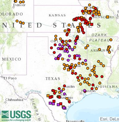
2 Significant Activity May Significant Events: Flooding Southern Plains Tropical Activity: Atlantic Tropical cyclone activity not expected next 48 hours Eastern Pacific Area 1 (Low, 30%); Area 2 (Medium, 50%) Central Pacific Tropical cyclone activity not expected next 48 hours Significant Weather: Severe thunderstorms possible Southern Plains to Lower/Middle Mississippi Valley Flash flooding possible Central/Southern Plains to Middle Mississippi Valley Rain & thunderstorms Northern Intermountain/Northern Plains, Southwest and Southeast, Great Lakes to Ohio/Tennessee valleys Elevated fire weather Northeast Red Flag Warnings AK Space Weather: Past 24 hours: no space weather storms observed; next 24 hours: none predicted Declaration Activity: None

 report road and highway closures with homes and businesses impacted and numerous high")
3 Flooding Southern Plains Situation: Heavy rain (over 5 inches) continues; ground is extremely saturated Major flooding in TX and OK with record levels reported in some areas Additional rain and flooding expected to spread into LA and AR today Impacts: Hardest hit counties in TX and OK (graphics at right) report road and highway closures with homes and businesses impacted and numerous high water rescues Media reports mandatory evacuations in effect for areas along Blanco River near Wimberley, TX (Hays County) due to flooding and rapid rise in river levels City of San Marcos, TX (Hays County) evacuating residents along the river Mandatory evacuations for residents near Lewis Creek Dam (Montgomery County TX) 1 confirmed firefighter fatality in OK during high water rescue Power outages: 45K customers across FEMA Region VI (DOE EAGLE-I as of 8:30 a.m. EDT) US Coast Guard Liaison to FEMA Hardest hit counties
 evacuating residents along the river Mandatory evacuations for residents near Lewis Creek Dam (Montgomery County TX) 1 confirmed firefighter fatality in OK during high water rescue Power")
 Flood preparation & response currently being handled by local emergency managers; state resources on alert TX EOC at Level I, Full Activation")

4 Flooding Southern Plains State/Local Response: 7 shelters open with 90 occupants in TX; 1 shelter open with no occupants in OK (ARC Shelter Report, 3:00 am EDT, May 24) Flood preparation & response currently being handled by local emergency managers; state resources on alert TX EOC at Level I, Full Activation AR & OK EOCs at Level III, Monitoring FEMA Response: Region VI RRCC at Level III (12:00-8:00 pm CDT) RWC at Enhanced Watch (7:00 am-12:00 pm CDT) LNOs deployed to TX; LNOs on standby to OK, AR & LA No requests for FEMA assistance US Coast Guard Liaison to FEMA Activated State EOCs River gages at Major Flood Stage

 Located 1,400 miles SE of Big Island of Hawaii Moving slowly W; could cross into Central Pacific basin later today Chance for development decreasing Probability of tropical cyclone development:")
5 2-Day Tropical Outlook Eastern Pacific Area 1 (as of 5:00 a.m. EDT) Located 1,400 miles SE of Big Island of Hawaii Moving slowly W; could cross into Central Pacific basin later today Chance for development decreasing Probability of tropical cyclone development: Next 48 hours: Low (30%) Next 5 days: Low (30%) Area 2 (as of 5:00 a.m. EDT) Located 1,500 miles WSW of Southern tip of Baja California Moving WNW at mph Some slow development could occur next day or so Probability of tropical cyclone development: Next 48 hours: Medium (50%) Next 5 days: Medium (50%) Area 3 (as of 5:00 a.m. EDT) Expected to form several hundred miles S of coast of Mexico next few days Moving WNW to NW Probability of tropical cyclone development: Next 48 hours: Low (near 0%) Next 5 days: Low (30%)
 Next 5 days: Low (30%) Area 2 (as of 5:00 a.m.")

6 Open Field Offices as of May 24

7 Disaster Requests & Declarations Declaration Requests in Process Requests APPROVED (since last report) Requests DENIED (since last report) 1 Date Requested 0 0 OK DR Severe Storms, Tornadoes, Straight-line Winds & Flooding May 19, 2015

8 Joint Preliminary Damage Assessments Region VI VII IX State / Location OK NE Guam CNMI Event Severe Storms and Flooding May 4-11, 2015 Severe Storms May 3-11, 2015 Typhoon Dolphin May 15-17, 2015 Typhoon Dolphin May 15-17, 2015 IA/PA Number of Counties Requested Complete Start End IA 4 4 5/14 5/15 PA /19 TBD PA /25 05/29 IA 1 0 5/17 TBD PA 1 0 5/17 TBD PA 1 0 5/19 TBD


9 National Weather Forecast Day 1 al_forecast/natfcst.php Today Tomorrow


10 Active Watches/Warnings


11 Precipitation Forecast, 1-3 Day Day 1 Day 2 Day 3


12 Precipitation Forecast, 7 Day


13 River Forecast ype=fcst&conus_map=d_map


14 Significant River Flood Outlook


15 Severe Weather Outlook, Days 1-3 Day 1 Day 2 Day 3 Categories Thunderstorms Marginal Risk Slight Risk Enhanced Risk Moderate Risk High Risk


16 Fire Weather Outlook, Days 1-8 Day 1 Day 2 Days 3-8

17 6-10 Day Outlooks y/610temp.new.gif prcp.new.gif Temperature Probability Precipitation Probability


18 Space Weather None Past 24 Hours Current Next 24 Hours Space Weather Activity: None None None Geomagnetic Storms None None None Solar Radiation Storms None None None Radio Blackouts None None None HF Communication Impact Sunspot Activity

19 FEMA Readiness Deployable Teams /Assets Deployable Teams/Assets Resource Status Total FMC Available Partially Available Not Available Detailed, Deployed, Activated Comments Rating Criterion FCO % FDRC % US&R % NM-TF1 (Red) Personnel shortages CA-TF2 (Green) Returned from Nepal TN-TF1 (Green) Completed rehab from Exercise OH-TF1 (Yellow) Rehab from Exercise National IMAT % IMAT East 1 Deployed to Guam Regional IMAT % MCOV % Region II (Blue) Training in AL Region III (Blue) Deployed to WV Region IX (Blue) Deployed to Guam Not Mission Capable (Red): Regions IV-3, VI-2 & IX-1 OFDC Readiness: FCO Green Yellow Red Type Type Type FDRC Green = Available/FMC Yellow = Available/PMC Red = Out-of-Service Blue = Assigned/Deployed Green: 3 avail Yellow: 1-2 avail Red: 0 avail (Individual N-IMAT red if 50% of Section Chiefs and/or Team Leader is unavailable for deployment.) Green: 7 or more avail Yellow: 4-6 teams available Red: > 8 teams deployed/unavailable R-IMAT also red if TL Ops/Log Chief is unavailable & has no qualified replacement Green = % avail Yellow = 60 79% avail Red = 59% or below avail Readiness remains 95%
: Regions IV-3, VI-2 & IX-1 OFDC Readiness: FCO Green Yellow Red Type 1 3+ 2 1 Type 2 4+ 3 2 Type 3 4 3 2 FDRC 3 2 1 Green = Available/FMC Yellow =")
20 FEMA Readiness National/Regional Teams Resource Status Total FMC Available Partially Available National/Regional Teams Not Available Deployed/ Activated NWC % 0 0 Not Activated NRCC % 0 44 Not Activated Comments Rating Criterion Green = FMC Yellow = PMC Red = NMC HLT 1 N/A N/A 0 0 Not Activated DEST Not Activated RRCCs % 0 0 Activated RWCs/MOCs % 0 0 Activated Region VI RRCC at Level III (12:00-8:00 pm CDT) Region VI RWC at Enhanced Watch (7:00 am-12:00 pm CDT)
 Region VI RWC at Enhanced Watch (7:00")
21 Hurricane Preparedness Week Be Prepared Get A PLAN! Know Your Evacuation Zone Hurricane Hazards: The primary hazards from hurricanes are storm surge flooding, inland flooding from heavy rains, destructive winds, tornadoes, and high surf and rip currents While hurricanes pose the greatest threat to life and property, tropical storms and depressions can also be devastating US Coast Guard Liaison to FEMA Vital resources: Tropical Cyclone Preparedness Guide (PDF) Hurricanes.gov, which provides critical hurricane advisories and marine forecasts Weather.gov for the latest forecasts for your part of the country Ready.gov for additional preparedness information National Hurricane Center Outreach Resources Weather-Ready Nation Kids (PDF) Ready.gov Kids

22
Daily Operations Briefing Wednesday, October 7, 2015 8:30 a.m. EDT
 Daily Operations Briefing Wednesday, October 7, 2015 8:30 a.m. EDT Flooding Southeast Situation: Most rivers, streams & creeks have crested in central SC Rivers are rising in eastern SC with crests expected
Daily Operations Briefing Saturday, September 3, 2016 8:30 a.m. EDT
 Daily Operations Briefing Saturday, September 3, 2016 8:30 a.m. EDT Significant Activity - Sept 2-3 Significant Events: See Tropical Activity Tropical Activity: Atlantic Tropical Storm Gaston; Tropical
Texas Department of Public Safety Texas Division of Emergency Management. Texas State Operations Center
 Texas Department of Public Safety Texas Division of Emergency Management Texas State Operations Center Situation Awareness Brief Saturday, July 20 th 2013 As of 0900 CDT Tropical Weather Outlook For the
Weather Briefing for Southeast Texas October 24 th, 2015
 Weather Briefing for Southeast Texas October 24 th, 2015 Dangerous Flash Flood Event Saturday through Sunday 8:16 AM Overview Ongoing: record deep moisture in place, elevated seas, rip currents, high surf,
Texas Department of Public Safety Texas Division of Emergency Management. Texas State Operations Center
 Texas Department of Public Safety Texas Division of Emergency Management Texas State Operations Center Situation Awareness Brief Saturday, October 26 th 2013 As of 0900 CDT Tropical Weather Outlook Incidents
Disaster Risk Reduction through people centered National Multi-hazard Early Warning System in the context of Maldives
 Disaster Risk Reduction through people centered National Multi-hazard Early Warning System in the context of Maldives Abdul Muhusin, Deputy Director Department of Meteorology, Maldives Fourth Technical
CRS 610 Ventura County Flood Warning System Website
 CRS 610 Ventura County Flood Warning System Website Purpose This document gives instructions and a description of the information available via the Ventura County Watershed Protection District s (VCWPD)
Preparing for A Flood
 Preparing for A Flood 1. Know if you are in a flood prone area. 2. Each year, update flood procedures to be followed by your company, employees and tenants: Including Emergency Contacts Evacuation Plans
Department of Commerce National Oceanic & Atmospheric Administration National Weather Service
 Department of Commerce National Oceanic & Atmospheric Administration National Weather Service NATIONAL WEATHER SERVICE WESTERN REGION SUPPLEMENT 2-2009 APPLICABLE TO INSTRUCTION NWSI 10-602 May 17, 2013
Antecedent Conditions:
 Antecedent Conditions: Record to Near Record Heat occurred across Northeast & North Central Colorado September 2-8. A cold front moved across Northeast Colorado the morning of the 9 th, and deeper subtropical
Multi-Jurisdictional Hazard Mitigation Plan
 Flooding General Flooding is the leading cause of death among all types of natural disasters throughout the United States, with its ability to roll boulders the size of cars, tear out trees, and destroy
Glossary. ambulance: a vehicle equipped for transportation of sick and injured persons. believe: to accept as true or real
 act: the process of doing or performing something ambulance: a vehicle equipped for transportation of sick and injured persons believe: to accept as true or real cascading disaster: the effects of one
Emergency Management is responsible for coordinating the City of Houston s preparation for and response to emergency situations.
 CITY OF HOUSTON Office of Emergency Management October 2004 Emergency Management is responsible for coordinating the City of Houston s preparation for and response to emergency situations. Houston is exposed
RISD Hurricane Preparedness
 RISD Hurricane Preparedness Hurricane It is the policy of RISD to view each hurricane threat as an extremely hazardous condition. As such, our goal is to minimize the risk to personnel consistent with
Flood After Fire Fact Sheet
 FACT SHEET Flood After Fire Fact Sheet Risks and Protection Floods are the most common and costly natural hazard in the nation. Whether caused by heavy rain, thunderstorms, or the tropical storms, the
Draft 8/1/05 SYSTEM First Rev. 8/9/05 2 nd Rev. 8/30/05 EMERGENCY OPERATIONS PLAN
 Draft 8/1/05 SYSTEM First Rev. 8/9/05 2 nd Rev. 8/30/05 EMERGENCY OPERATIONS PLAN I. INTRODUCTION A. PURPOSE - The University of Hawaii System Emergency Operations Plan (EOP) provides procedures for managing
Flood Hazard Mitigation
 District of Columbia Homeland Security and Emergency Management Agency Flood Hazard Mitigation DC Homeland Security and Emergency Management Agency 2720 Martin Luther King Jr., Avenue, SE Washington, DC
Flood Protection Tips
 Flood Protection Tips Information About Floodplains and Flood Prevention What is a floodplain? Floodplains serve many useful purposes, and those that are preserved in their natural or nearly natural state
CEMP Criteria for Residential Treatment Facilities
 CEMP Criteria for Residential Treatment Facilities Lee County Emergency Management The following minimum criteria are to be used when Comprehensive Emergency Management Plans (CEMP) for all Residential
Emergency Management Planning Criteria For Residential Treatment Facilities
 Emergency Management Planning Criteria For Residential Treatment Facilities The following minimum criteria are to be used for Comprehensive Emergency Management Plans (CEMP) for Therapeutic Group Homes
Georgia College Emergency Notification System Activation Protocols
 Georgia College Emergency Notification System Activation Protocols Georgia College & State University Office of Emergency Preparedness and Occupational Safety December 2013 I. Introduction and Purpose
City of Salinas Flood Response Preparations
 City of Salinas Flood Response Preparations Winter Preparations Goals for 2015/2016 Community Preparedness in the event of flooding Media cooperation on safety and preparedness, public information sharing
Zurich easy-tough guide to starting a hurricane emergency action plan
 2-7.017 October 2008 Zurich easy-tough guide to starting a hurricane emergency action plan Introduction Is your building located in a hurricane-prone region? Do you need to prepare a hurricane emergency
Department of Commerce National Oceanic & Atmospheric Administration National Weather Service
 Department of Commerce National Oceanic & Atmospheric Administration National Weather Service NATIONAL WEATHER SERVICE WESTERN REGION SUPPLEMENT 17-2003 APPLICABLE TO NWSI 10-701 MARCH 16, 2015 Operations
The IPCC Special Report on Managing the Risks of Extreme Events and Disasters to Advance Climate Change Adaptation
 The IPCC Special Report on Managing the Risks of Extreme Events and Disasters to Advance Climate Change Adaptation A changing climate leads to changes in extreme weather and climate events 2 How do changes
Homeland Security Plan for Iowa State University Extension Field Offices
 Homeland Security Plan for Iowa State University Extension Field Offices Homeland security covers natural disaster events such as a flood, drought, or winter storm, as well as terrorist events from a physical,
A.4 SEVERE WEATHER PLAN
 Page 1 of 5 A.4 SEVERE WEATHER PLAN 1.0 Purpose 1.1 The purpose of this Severe Weather Response Plan is to minimize the impact on the University from a severe weather incident 2.0 Applicability 2.1 This
Town of Amherst Flood Plan Annex
 Town of Amherst Flood Plan Annex The following document is an annex to the Town of Amherst Disaster Plan and is specifically used as a guideline for Flooding events Flood Plans can enable a flexible response
Hurricanes. Characteristics of a Hurricane
 Hurricanes Readings: A&B Ch. 12 Topics 1. Characteristics 2. Location 3. Structure 4. Development a. Tropical Disturbance b. Tropical Depression c. Tropical Storm d. Hurricane e. Influences f. Path g.
A Mariner s Guide to Marine Weather Services Great Lakes
 A Mariner s Guide to Marine Weather Services Great Lakes U.S. DEPARTMENT OF COMMERCE National Oceanic and Atmospheric Administration National Weather Service NOAA PA 98053 Introduction Few people are affected
EMERGENCY MANAGEMENT PLANNING CRITERIA FOR AMBULATORY SURGICAL CENTERS
 EMERGENCY MANAGEMENT PLANNING CRITERIA FOR AMBULATORY SURGICAL CENTERS The following criteria are to be used when developing Comprehensive Emergency Management Plans (CEMP) for all ambulatory surgical
Storms Short Study Guide
 Name: Class: Date: Storms Short Study Guide Multiple Choice Identify the letter of the choice that best completes the statement or answers the question. 1. A(n) thunderstorm forms because of unequal heating
El Nino in the OC. Orange County Sheriff s Department Emergency Management Division
 El Nino in the OC Orange County Sheriff s Department Emergency Management Division The mission of the Orange County Sheriff s Department s Emergency Management Division is to promote, facilitate, and support
HURRICANE ISAAC. National Disaster Recovery Framework (NDRF) Long Term Recovery Group (LTRG) Citizens Advisory Committee (CAC)
 Long Term Recovery Group (LTRG) Citizens Advisory Committee (CAC)") HURRICANE ISAAC National Disaster Recovery Framework (NDRF) Long Term Recovery Group (LTRG) Citizens Advisory Committee (CAC) 1 ABOUT ST. JOHN THE BAPTIST PARISH Population: 45,924 Cities: LaPlace, Reserve,
HURRICANE ISAAC National Disaster Recovery Framework (NDRF) Long Term Recovery Group (LTRG) Citizens Advisory Committee (CAC) 1 ABOUT ST. JOHN THE BAPTIST PARISH Population: 45,924 Cities: LaPlace, Reserve,
2013 Annual Climate Summary for the Southeast United States
 Months of heavy rain forced the U.S. Army Corp of Engineers to open the spillways at Lake Hartwell, located at the headwaters of the Savannah River along the South Carolina-Georgia border, on July 9,.
Chapter 6. Emergency Services
 Chapter 6. Emergency Services Most communities appoint an emergency manager or emergency services coordinator. This person is usually part time, although many communities make it an extra duty for a full-time
Probability Magnitude/Severity Warning Time Duration CPRI Flood 3.25 2.88 2.50 3.13 3.01
 3.7.8 FLOOD Probability Magnitude/Severity Warning Time Duration CPRI Flood 3.25 2.88 2.50 3.13 3.01 Description Flooding is the most frequent and costly natural hazard in the United States. During the
Hurricanes and Storm Surge www.hcfcd.org/tropicalweather
 Hurricanes and Storm Surge www.hcfcd.org High-level winds fl ow outward Strong surface winds spiral inward EYE Calm, sometimes cloudfree, sinking air Air sinks in calm area at the storm s eye THUNDERSTORMS
Emergency Preparedness Tips and Actions for the Workplace
 Emergency Preparedness Tips and Actions for the Workplace Is Your Business Disaster Ready? Disaster and emergencies can happen anytime and anywhere in Minnesota. 52 Presidential Disaster Declarations between
MARCH 31, 2010 - WEDNESDAY
 MARCH 31, 2010 - WEDNESDAY GENERAL SESSIONS Buffalo Plane Crash This session will focus on the emergency manager s overview of the Buffalo New York plane crash of Continental 3407. Overview of November
The Pennsylvania Observer
 The Pennsylvania Observer August 3, 2009 July 2009 - Pennsylvania Weather Recap Written by: Dan DePodwin After a cool month of June, some hoped July would bring usual summertime warmth to the state of
Improved Warnings for Natural Hazards: A Prototype System for Southern California
 Improved Warnings for Natural Hazards: A Prototype System for Southern California Yehuda Bock Research Geodesist Scripps Institution of Oceanography University of California San Diego, La Jolla, Calif.
Heavy Rainfall from Hurricane Connie August 1955 By Michael Kozar and Richard Grumm National Weather Service, State College, PA 16803
 Heavy Rainfall from Hurricane Connie August 1955 By Michael Kozar and Richard Grumm National Weather Service, State College, PA 16803 1. Introduction Hurricane Connie became the first hurricane of the
Anyone Else Notice That Its Been Windy Lately?
 National Weather Service Aberdeen, South Dakota January 2014 Inside this issue: Has it Been Windy Lately or What? 2013 Year in Review 2013 Year in Review (cont.) 1 2 3 Has it Been Windy Lately or What?
Town of Warwick, Village of Florida, Village of Greenwood Lake and Village of Warwick MULTI JURISIDICTIONAL, MULTI HAZARD MITIGATION PLAN DRAFT
 Town of Warwick, Village of Florida, Village of Greenwood Lake and Village of Warwick MULTI JURISIDICTIONAL, MULTI HAZARD MITIGATION PLAN DRAFT Appendix B Historical Hazard Documentation Rev #0 May 2013
Tropical Program Update
 Tropical Program Update Mark Tew Chief, Marine and Coastal Weather Services Branch Office of Climate, Water, and Weather Services [email protected] 301-713-1677 x 125 Changes to the Tropical Warning Program
Situation Report #2 Hurricane Irene impact on Turks and Caicos Islands and The Bahamas (as at 5:00 p.m.)
") Situation Report #2 Hurricane Irene impact on Turks and Caicos Islands and The Bahamas (as at 5:00 p.m.) Hurricane Irene impacting the Turks and Caicos Islands and Bahamas Message: Hurricane Irene a Category
Situation Report #2 Hurricane Irene impact on Turks and Caicos Islands and The Bahamas (as at 5:00 p.m.) Hurricane Irene impacting the Turks and Caicos Islands and Bahamas Message: Hurricane Irene a Category
Hurricanes: Nature's Wildest Storms by Erin Ryan
 Name: : Nature's Wildest Storms by Erin Ryan You may already know that hurricanes are major tropical storms that can cause devastating waves, wind, and rain. They happen during Hurricane Season, which
Flood Emergency Response Planning: How to Protect Your Business from a Natural Disaster RIC005
 Flood Emergency Response Planning: How to Protect Your Business from a Natural Disaster RIC005 Speakers: Tom Chan, CEO, Global Risk Miyamoto Greg Bates, Principal, Global Risk Consultants Learning Objectives
Emergency Management Planning Criteria for Assisted Living Facilities (State Criteria Form)
") Emergency Management Planning Criteria for Assisted Living Facilities (State Criteria Form) FACILITY INFORMATION: FACILITY NAME: FIELD (ALF Company) ST. LIC. NO.: FIELD (Lic. #) FAC. TYPE: ALF STATE RULE:
Emergency Management Planning Criteria for Assisted Living Facilities (State Criteria Form) FACILITY INFORMATION: FACILITY NAME: FIELD (ALF Company) ST. LIC. NO.: FIELD (Lic. #) FAC. TYPE: ALF STATE RULE:
Follow That Hurricane!
 Discover Your World With NOAA Follow That Hurricane! What You Will Do Devastating damage expected A most Track a hurricane on the same powerful hurricane with unprecedented type of chart used at the strength
CHAPTER 7. EMERGENCY SERVICES
 CHAPTER 7. EMERGENCY SERVICES Although better forecasts and warning processes have helped save lives by providing more lead time to evacuate, the tremendous growth of development and human population in
NATHAN world map of natural hazards. 2011 version
 world map of natural hazards 2011 version World Map of Natural Hazards Geointelligence for your business A new name but the recipe for success is the same: In the 2011 version, we are offering both proven
7) Coastal Storms: Multi-Hazard Analysis for New York City
 Coastal Storms: Multi-Hazard Analysis for New York City") 7) Coastal Storms: Multi-Hazard Analysis for New York City a) Hazard Profile i) Hazard Description Coastal storms, including nor'easters, tropical storms, and hurricanes, can and do affect New York City.
7) Coastal Storms: Multi-Hazard Analysis for New York City a) Hazard Profile i) Hazard Description Coastal storms, including nor'easters, tropical storms, and hurricanes, can and do affect New York City.
Climate Change in North Carolina
 Climate Change in North Carolina Dr. Chip Konrad Director of the The Southeast Regional Climate Center Associate Professor Department of Geography University of North Carolina at Chapel Hill The Southeast
CITY OF HUMBLE OFFICE OF EMERGENCY MANAGEMENT. 110 W. Main St. Humble, Tx. 77338 ph. 281 446 4928 Email; [email protected]
 CITY OF HUMBLE OFFICE OF EMERGENCY MANAGEMENT 110 W. Main St. Humble, Tx. 77338 ph. 281 446 4928 Email; [email protected] Emergency Management Director: Mayor Donnie McMannes Emergency Management
OVERSIGHT HEARING ON THE LIFESAVING ROLE OF ACCURATE HURRICANE PREDICTION
 WRITTEN TESTIMONY OF MR. MAX MAYFIELD, DIRECTOR TROPICAL PREDICTION CENTER/NATIONAL HURRICANE CENTER NATIONAL WEATHER SERVICE NATIONAL OCEANIC AND ATMOSPHERIC ADMINISTRATION U. S. DEPARTMENT OF COMMERCE
Emergency Management
 LESSON PLAN 5 Be Disaster Safe Learning that there is a system in place and that agencies cooperate to take care of the community s needs during emergencies and disasters reassures and supports students.
Real-time Ocean Forecasting Needs at NCEP National Weather Service
 Real-time Ocean Forecasting Needs at NCEP National Weather Service D.B. Rao NCEP Environmental Modeling Center December, 2005 HYCOM Annual Meeting, Miami, FL COMMERCE ENVIRONMENT STATE/LOCAL PLANNING HEALTH
A Review of Power Outages and Restoration Following the June 2012 Derecho
 A Review of Power Outages and Restoration Following the June 2012 Derecho Infrastructure Security and Energy Restoration Office of Electricity Delivery and Energy Reliability U.S. Department of Energy
HAZARD VULNERABILITY & RISK ASSESSMENT
 Hazard Vulnerability Analysis Purpose and Scope A Hazard Vulnerability Analysis (HVA) evaluates risk associated with a specific hazard. During this analysis, the hazard is evaluated for its probability
SEPTEMBER 20-23, 2009
 ATLANTA FLOODS: SEPTEMBER 20-23, 2009 Melissa Tuttle Carr - Freelance Meteorologist, CNN GAFM Annual Conference, March 24, 2010 Why I m Here Meteorologist with emphasis in communications Work to integrate
PACIFIC CATASTROPHE RISK ASSESSMENT AND FINANCING INITIATIVE
 PACIFIC CATASTROPHE RISK ASSESSMENT AND FINANCING INITIATIVE NIUE SEPTEMBER 11 COUNTRY RISK PROFILE: NIUE Niue is expected to incur, on average,.9 million USD per year in losses due to earthquakes and
Franklin County Emergency Management Department (FCEMD) All County Emergency Response Team (CERT) Agencies. Table of Contents
 All County Emergency Response Team (CERT) Agencies. Table of Contents") Concept of Operations Lead Agency Support Agency Standard Operating Procedures Emergency Operations Center (EOC) Franklin County Emergency Management Department (FCEMD) All County Emergency Response Team
Concept of Operations Lead Agency Support Agency Standard Operating Procedures Emergency Operations Center (EOC) Franklin County Emergency Management Department (FCEMD) All County Emergency Response Team
Climate Change in Mexico implications for the insurance and reinsurance market
 Climate Change in Mexico implications for the insurance and reinsurance market Eberhard Faust Geo Risks Research Munich Reinsurance Company 1980 April 2008: Billion & Ten Billion Dollar Losses The costliest
EMERGENCY MANAGEMENT PLANNING & COMPLIANCE REVIEW CRITERIA FOR NURSING HOMES [FL RULE CHAPTER 59A-4.126 F.A.C]
![EMERGENCY MANAGEMENT PLANNING & COMPLIANCE REVIEW CRITERIA FOR NURSING HOMES [FL RULE CHAPTER 59A-4.126 F.A.C]](/thumbs/33/16547086.jpg "EMERGENCY MANAGEMENT PLANNING & COMPLIANCE REVIEW CRITERIA FOR NURSING HOMES [FL RULE CHAPTER 59A-4.126 F.A.C]") EMERGENCY MANAGEMENT PLANNING & COMPLIANCE REVIEW CRITERIA FOR NURSING HOMES [FL RULE CHAPTER 59A-4.126 F.A.C] Notice: Facilities must submit their plans with the appropriate page numbers shown in the
EMERGENCY MANAGEMENT PLANNING & COMPLIANCE REVIEW CRITERIA FOR NURSING HOMES [FL RULE CHAPTER 59A-4.126 F.A.C] Notice: Facilities must submit their plans with the appropriate page numbers shown in the
FLOOD FORECASTING PRACTICE IN NORTHERN CALIFORNIA
 FLOOD FORECASTING PRACTICE IN NORTHERN CALIFORNIA California Department of Water Resources Post Office Box 219000, Sacramento, California 95821 9000 USA By Maurice Roos, Chief Hydrologist ABSTRACT Although
AMBULATORY SURGICAL CENTERS (Based upon AHCA Form # 3130-2003 JUL 94)
") (Based upon AHCA Form # 3130-2003 JUL 94) The document below is the cross-reference used by Palm Beach County Division of Emergency Management for the annual review and re-certification of your CEMP. Review
(Based upon AHCA Form # 3130-2003 JUL 94) The document below is the cross-reference used by Palm Beach County Division of Emergency Management for the annual review and re-certification of your CEMP. Review
HURRICANE EVACUATION GUIDE
 booklet-final 6/30/00 9:41 AM Page 1 E M E R G E N C Y P R E P A R E D N E S S HURRICANE EVACUATION GUIDE Vital information you need to know in case of a hurricane evacuation. Information brought to you
With a combination of soaking rain, flying debris, high winds, and tidal surges, Hurricanes and tropical storms can pack a powerful punch.
 With a combination of soaking rain, flying debris, high winds, and tidal surges, Hurricanes and tropical storms can pack a powerful punch. Besides causing extensive damage in coastal areas, hurricanes
Communications Systems Used in the USA TARNS. Chris Hill, Meteorologist in Charge (ret) National Weather Service Seattle, Washington, USA
 National Weather Service Seattle, Washington, USA") Communications Systems Used in the USA TARNS Chris Hill, Meteorologist in Charge (ret) National Weather Service Seattle, Washington, USA Washington Faces Many Non-Weather Hazards Earthquakes Tsunamis Terrorism
Communications Systems Used in the USA TARNS Chris Hill, Meteorologist in Charge (ret) National Weather Service Seattle, Washington, USA Washington Faces Many Non-Weather Hazards Earthquakes Tsunamis Terrorism
EMERGENCY MANAGEMENT PLANNING CRITERIA FOR HOSPITALS
 EMERGENCY MANAGEMENT PLANNING CRITERIA FOR HOSPITALS The following minimum criteria are to be used when developing Comprehensive Emergency Management Plans (CEMP) for all hospitals. These criteria will
Challenges. Estimated Damages from 100-Year Flood
 Suffield Suffield is a rural community located along the Massachusetts border. It encompasses about 42.2 square miles and has a population of about 15,735. Suffield s terrain rises from an elevation of
NURSING HOME STATUE RULE CRITERIA
 NURSING HOME STATUE RULE CRITERIA Page 1 of 11 Nursing Homes Statutory Reference 8 400.23 (2)(g), Florida Statutes Rules; criteria; Nursing Home Advisory Committee; evaluation and rating system; fee for
AMBULATORY SURGICAL CENTERS
 AMBULATORY SURGICAL CENTERS STATUTE RULE CRITERIA Current until changed by State Legislature or AHCA Hospitals and Ambulatory Surgical Centers Statutory Reference 3 395.1055 (1)(c), Florida Statutes Rules
Emergency Management Planning Criteria for Ambulatory Surgical Centers (State Criteria Form)
") Emergency Management Planning Criteria for Ambulatory Surgical Centers (State Criteria Form) FACILITY INFORMATION: FACILITY NAME: FIELD (Company) FAC. TYPE: ASC STATE RULE: 59A-5, F.A.C CONTACT PERSON:
Emergency Management Planning Criteria for Ambulatory Surgical Centers (State Criteria Form) FACILITY INFORMATION: FACILITY NAME: FIELD (Company) FAC. TYPE: ASC STATE RULE: 59A-5, F.A.C CONTACT PERSON:
HURRICANE EMERGENCY PLAN (Updated 04/28/11)
") DEPARTMENT OF LAND AND NATURAL RESOURCES (DLNR) DIVISION OF BOATING AND OCEAN RECREATION (DOBOR) HURRICANE EMERGENCY PLAN (Updated 04/28/11) I. Purpose The following is intended to inform affected parties
DEPARTMENT OF LAND AND NATURAL RESOURCES (DLNR) DIVISION OF BOATING AND OCEAN RECREATION (DOBOR) HURRICANE EMERGENCY PLAN (Updated 04/28/11) I. Purpose The following is intended to inform affected parties
Climate Change Long Term Trends and their Implications for Emergency Management August 2011
 Climate Change Long Term Trends and their Implications for Emergency Management August 2011 Overview A significant amount of existing research indicates that the world s climate is changing. Emergency
A. Service Description: Background
 National Weather Service (NWS) Service Description Document (SDD) Proposed Enhanced Impact-Based Decision Support Services, for the Emergency Management Community and Government Core Partners, Supporting
MEDIA RELEASE No.4 SEVERE TROPICAL CYCLONE ULA AND TROPICAL DEPRESSION 07F A TROPICAL CYCLONE ALERT IS NOW INFORCE FOR THE LAU GROUP.
 MEDIA RELEASE No.4 SEVERE TROPICAL CYCLONE ULA AND TROPICAL DEPRESSION 07F 4pm Friday 01 st January 2016 A TROPICAL CYCLONE ALERT IS NOW INFORCE FOR THE LAU GROUP. At 1pm today, Severe Tropical Cyclone
How To Assess Natural Hazards In Houston County, Minn.
 Natural Hazards Assessment Houston County, MN Prepared by: NOAA / National Weather Service La Crosse, WI Natural Hazards Assessment for Houston County, MN Prepared by NOAA / National Weather Service La