Primary author: Kaspar, Frank (DWD - Deutscher Wetterdienst), [email protected]
|
|
|
- Amber Watkins
- 10 years ago
- Views:
Transcription
1 Primary author: Kaspar, Frank (DWD - Deutscher Wetterdienst), [email protected] Co-authors: Johannes Behrendt (DWD - Deutscher Wetterdienst), Klaus-Jürgen Schreiber (DWD - Deutscher Wetterdienst) Abstract ID: 1O2 The Climate Data Centre of Deutscher Wetterdienst (DWD) In 2009 the German meteorological service (Deutscher Wetterdienst, DWD) has started to set up a Climate Data Centre (CDC) in order to provide homogeneous access to its variety of climate data especially to users from research, educational and public institutions. CDC acts as a central point of contact to various data collections of DWD. These include observations from German weather stations and DWD's observatories, special data from hydroclimatology, agro-climatology and medical climatology, but also from international activities of DWD, such as the Global Precipitation Climatology Center (GPCC), EUMETSAT's Satellite Application Facility on Climate Monitoring (CM-SAF) or marine climatological data (ship and buoy observations) of the Global Collecting Centre for Marine Climatological Data. Data are based on conventional surface observations over land and ocean as well as on various remote sensing methods, such as satellite observation. The major part consists of climate data from the past, but CDC will also include results from scenario calculations and projections for the future. In addition to pure observational data, CDC offers derived statistical parameters and spatial analyses as gridded datasets. As first step, a central data catalogue provides standardised descriptions and information on data access. It follows national and international rules for the description of geo-referenced data (GDI- DE; INSPIRE). DWD has also started activities to provide data in standardised file formats. Considering the needs of different user communities, DWD decided to provide its gridded datasets in NetCDF following the Climate and Forecast Convention (CF). As users would benefit from a concerted decision of European meteorological services, we welcome any discussion of this issue.

2 The Climate Data Center of DWD Frank Kaspar

3 Overview Motivation for the new Climate Data Center Existing data centers at DWD Aims & concept of CDC Catalogue for metadata (GeoNetwork-Opensource) Concepts for access to data Some related internal activities (standardized data formats and projections; digital object identifiers) 2

4 Motivation for the new Climate Data Center Initital situation: Several individual data centers exit at DWD due to a number of national and international activities of DWD Increasing interest from climate research community for various data. New national and international standards and regulation for geo-referenced data (e.g. INSPIRE) 3
 3")
5 Existing individual data centers at DWD 4

6 Overview of data pools at DWD (1/6) DWD s National Climate Data Centre (NKDZ) Traditional climate data from German weather stations, based on the station network of DWD. Accessible via WebWerdis (Web-Based Weather Request and Distribution System) See talk of Johannes Behrendt (next talk) Bremen mean annual temperature Air temperature August
 Bremen mean annual temperature Air temperature")
7 Overview of data pools at DWD (2/6) Global climate data from weather stations, available from the archive of worldwide CLIMAT data (freely available global data set, monthly values) Global marine climatological data (ship and buoy observations) of the Global Collecting Centre for Marine Climatological Data) (Wolfgang Gloeden, member of that department, is in the audience) About 188 million weather observations of ships are in the DWD-archives (conditions ). 6
 About 188 million weather observations of ships are in the DWD-archives (conditions 31.")
8 Overview of data pools at DWD (3/6) physical data from the Lindenberg Meteorological Observatory air chemistry data from the Hohenpeißenberg Meteorological Observatory special hydroclimatological data (radar precipitation measurements, ombrometer data,...) from Germany. special agro-climatological data (phenology, soil moisture,...) from Germany special data for medical climatology (under construction: pollen monitoring, particulate matter,...) for Germany. special climatological data for technical applications (wind data, climate factors for energy performance certificates, degree-day indices, test reference years, ) for Germany 7
 from Germany special data for medical climatology (under construction: pollen monitoring, particulate matter,...) for Germany.")
9 Overview of data pools at DWD (4/6) Satellite Application Facility on Climate Monitoring (CM-SAF; component of EUMETSAT s ground segment): regional and global satellite-based climate monitoring products (see Poster of Kaspar et al., tomorrow). Surface radiation budget / Wm Monthly mean cloud cover June 2007 derived from AVHRR (polar orbiters) Monthly mean surface radiation budget for September 2007 derived from Meteosat- 9/SEVIRI (geostationary satellite) 8
 Monthly mean surface radiation budget for September 2007 derived from Meteosat- 9/SEVIRI (geostationary")
10 Overview of data pools at DWD (5/6) Global Precipitation Climatology Centre (GPCC): gridded global precipitation products 9

11 Overview of data pools at DWD (6/6) data on climate change from regional climate monitoring activities for Germany and Europe (observed) data on climate change from regional climate projections for Germany (future, model based) 10

12 Problems: All data centers with individual (technical) ways (or none at all) to access the data (ftp, direct download, online ordering, WebWerdis, ). Difficult to get an overview over existing data from DWD homepage. Different data policy (e.g. within national and international activities; depending on user status). Different data formats and structures

13 Conceptof theclimatedatacenter 12

14 Concept and long-term objectives of CDC concentration of all access possibilities to past, current and projected climate data of the DWD and other data providers provision of a central, uniform interface for the access to climate data creation of an extensive data catalogue taking account of national and international rules and standards relating to the description of geo-referenced data (GDI-DE; INSPIRE) Current focus on research and education 13
 Current focus on research and")
15 Need for standardized metadata INSPIRE (EU: Infrastructure for Spatial Information in the European Community) WMO also asks for standardized metadata for usage in their WMO Information System (WIS): Global Information System Centres (GISC) Data Collection und Production Centres (DCPC) National Centres (NC) 14
 Data Collection und Production Centres (DCPC) National")
16 First step: catalogue for Metadata based on GeoNetwork-opensource Developed and published by Food and Agriculture Organization of the UN (FAO) Editing and publishing of metadata in standardised format Exchange of metadata between distributed catalogues Direct download of data User management 15

17 16

18 Examples from CDC catalogue 17

19 Homepage of CDC Overview About CDC Subject-related data sets CDC data catalogue Access to data Contact 18

20 Metadata catalogue 19
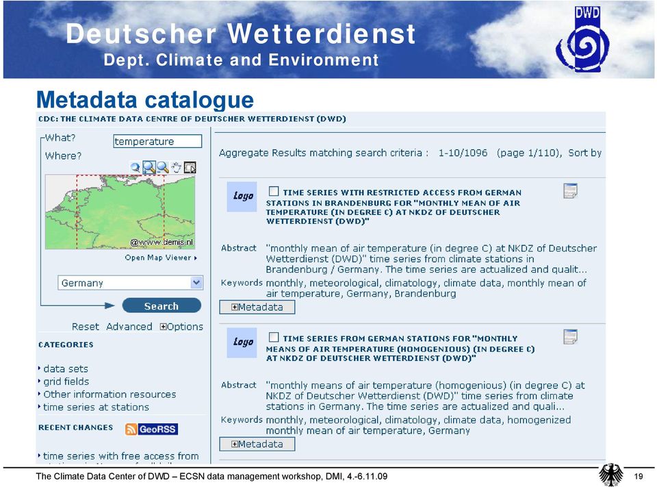
21 Example for details of metadata 20
22 CDC-catalogue: Distribution info 21
23 CDC-catalogue: Regional extent, data quality 22
24 CDC-Katalog Beispiele: More metadata / point of contact 23
25 CDC-catalogue: Direct download Interactive map (not yet implemented) 24
26 CDC-catalogue: Set of files for download 25
27 CDC-catalogue: Direct download. 26
28 CDC-catalogue: Advanced search e.g. show only entries with downloadable data 27
29 CDC-catalogue Group-specific permissions 28
30 CDC-catalogue Editing Metadata 29
31 CDC-catalogue XML-output 30
32 Conclusions: CDC catalogue Catalogue is based on GeoNetwork-opensource Editing of standardized metadata can be done by data providers Metadata in standardised format allows exchange between distributed catalogues Direct download of data (later: visualisation within catalogue) is possible Group-/user-specfic permissions can be set These activities also support requirements of WMO Information System 31
33 Some related activites 32
34 Standardized file format for raster data: netcdf? What Is netcdf? NetCDF (network Common Data Form) is a set of interfaces for array-oriented data access and a freely-distributed collection of data access libraries for C, Fortran, C++, Java, and other languages. The netcdf libraries support a machine-independent format for representing scientific data. Together, the interfaces, libraries, and format support the creation, access, and sharing of scientific data. NetCDF data is: Self-Describing. A netcdf file includes information about the data it contains. Portable. A netcdf file can be accessed by computers with different ways of storing integers, characters, and floating-point numbers. Scalable. A small subset of a large dataset may be accessed efficiently. Appendable. Data may be appended to a properly structured netcdf file without copying the dataset or redefining its structure. Sharable. One writer and multiple readers may simultaneously access the same netcdf file. Archivable. Access to all earlier forms of netcdf data will be supported by current and future versions of the software. 33
35 NetCDF Climate and Forecast (CF) Metadata Convention defines a standard for the internal structure of NetCDF-files, and therefore allows to build generic software tools to analyse such data. 34
36 Example for simple handling of CF-data. Use of climate data operators for very simple implementation of file-based data analysis. Example : Select grid cells of an administrative unit, and calculate mean precipitation of that area. cdo -eqc,27 verw_epm.nc select27.nc cdo -fldmean -mul precip_01_1961_30.nc select27.nc fldmean27.nc 35
37 Citable publication of scientific data based on digital object identifiers : Advantages: data are visible in library catalogue, data can be cited in scientific studies with a reliable reference, data provider guarantees that data will not change. 36
38 Thank you for your attention! 37
Structure? Integrated Climate Data Center How to use the ICDC? Tools? Data Formats? User
 Integrated Climate Data Center? Data Formats?? Tools???? visits Structure???? User Contents Which Data Formats do we offer? What is the Structure of our data center? Which Tools do we provide? Our Aims
Observation Metadata and its Use in the DWD Weather Data Request Broker
 Observation Metadata and its Use in the DWD Weather Data Request Broker Jürgen Seib Deutscher Wetterdienst e-mail: [email protected] What kind of metadata is needed for the discovery of observation data?
DATA ACCESS AT EUMETSAT
 1 EUM/OPS/VWG/15/793789 v1a DATA ACCESS AT EUMETSAT Copernicus Climate Data Store Workshop ECMWF 3-6 March 2015 Harald Rothfuss Overview of Presentation 1. Introduction to EUMETSAT 2. EUMETSAT Data Access
PART 1. Representations of atmospheric phenomena
 PART 1 Representations of atmospheric phenomena Atmospheric data meet all of the criteria for big data : they are large (high volume), generated or captured frequently (high velocity), and represent a
"CLIMATE DATA OPERATORS" AS A USER-FRIENDLY PROCESSING TOOL FOR CMSAF'S SATELLITE-DERIVED CLIMATE MONITORING PRODUCTS
 "CLIMATE DATA OPERATORS" AS A USER-FRIENDLY PROCESSING TOOL FOR CMSAF'S SATELLITE-DERIVED CLIMATE MONITORING PRODUCTS Frank Kaspar 1, Uwe Schulzweida 2, Ralf Müller 2 1 Satellite Application Facility on
Scientific Data Management and Dissemination
 Federal GIS Conference February 9 10, 2015 Washington, DC Scientific Data Management and Dissemination John Fry Solution Engineer, Esri [email protected] Agenda Background of Scientific Data Management through
Baudouin Raoult, Iryna Rozum, Dick Dee
 ECMWF contribution to the EU funded CHARME Project: A Significant Event Viewer tool Matthew Manoussakis Baudouin Raoult, Iryna Rozum, Dick Dee 5th Workshop on the use of GIS/OGC standards in meteorology
ICSU/WMO World Data Center for Remote Sensing of the Atmosphere (WDC RSAT)
") ICSU/WMO World Data Center for Remote Sensing of the Atmosphere (WDC RSAT) Beate Hildenbrand (et al.) German Aerospace Center (DLR) GAW 2009, Geneva, 05 07 May 2009 http://wdc.dlr.de WDC RSAT overview
ICSU/WMO World Data Center for Remote Sensing of the Atmosphere (WDC RSAT) Beate Hildenbrand (et al.) German Aerospace Center (DLR) GAW 2009, Geneva, 05 07 May 2009 http://wdc.dlr.de WDC RSAT overview
The European (RA VI) Regional Climate Centre Node on Climate Monitoring
 Regional Climate Centre Node on Climate Monitoring") The European (RA VI) Regional Climate Centre Node on Climate Monitoring Peter Bissolli Deutscher Wetterdienst, Germany WMO RA VI Regional Climate Centre (RCC) 1 Outline 1. Overview of the Regional Climate
The European (RA VI) Regional Climate Centre Node on Climate Monitoring Peter Bissolli Deutscher Wetterdienst, Germany WMO RA VI Regional Climate Centre (RCC) 1 Outline 1. Overview of the Regional Climate
NCDC s SATELLITE DATA, PRODUCTS, and SERVICES
 **** NCDC s SATELLITE DATA, PRODUCTS, and SERVICES Satellite data and derived products from NOAA s satellite systems are available through the National Climatic Data Center. The two primary systems are
EUMETSAT Satellite Programmes
 EUMETSAT Satellite Programmes Nowcasting Applications Developing Countries Marianne König [email protected] WSN-12 Rio de Janeiro 06-10 August 2012 27 Member States & 4 Cooperating States Member
Norwegian Satellite Earth Observation Database for Marine and Polar Research http://normap.nersc.no USE CASES
 Norwegian Satellite Earth Observation Database for Marine and Polar Research http://normap.nersc.no USE CASES The NORMAP Project team has prepared this document to present functionality of the NORMAP portal.
The Current Status of the EUMETNET Programme UNIDART
 The Current Status of the EUMETNET Programme UNIDART Jürgen Seib Deutscher Wetterdienst Database Management Department e-mail: [email protected] The main goal Development of a Web-based information system
Armenian State Hydrometeorological and Monitoring Service
 Armenian State Hydrometeorological and Monitoring Service Offenbach 1 Armenia: IN BRIEF Armenia is located in Southern Caucasus region, bordering with Iran, Azerbaijan, Georgia and Turkey. The total territory
NCDC Strategic Vision
 NOAA s National Climatic Data Center World s Largest Archive of Climate and Weather Data Presented to: Coastal Environmental Disasters Data Management Workshop September 16, 2014 Stephen Del Greco Deputy
Proposal for a Discovery-level WMO Metadata Standard
 WORLD METEOROLOGICAL ORGANIZATION MEETING OF EXPERT TEAM ON INTEGRATED DATA MANAGEMENT GENEVA, 17-20 SEPTEMBER 2001 ET-IDM/Doc. 3(1) (12.VI.2001) ITEM: 1.2 ENGLISH ONLY Proposal for a Discovery-level WMO
ANALYSIS OF DATA EXCHANGE PROBLEMS IN GLOBAL ATMOSPHERIC AND HYDROLOGICAL NETWORKS SUMMARY REPORT 1. June 2004
 ANALYSIS OF DATA EXCHANGE PROBLEMS IN GLOBAL ATMOSPHERIC AND HYDROLOGICAL NETWORKS SUMMARY REPORT 1 June 2004 Global Climate Observing System (GCOS) Secretariat 1 This summary report is based on a study
Product Navigator User Guide
 Product Navigator User Guide Table of Contents Contents About the Product Navigator... 1 Browser support and settings... 2 Searching in detail... 3 Simple Search... 3 Extended Search... 4 Browse By Theme...
Open Source Visualisation with ADAGUC Web Map Services
 Open Source Visualisation with ADAGUC Web Map Services Maarten Plieger Ernst de Vreede John van de Vegte, Wim Som de Cerff, Raymond Sluiter, Ian van der Neut, Jan Willem Noteboom 1 ADAGUC project Cooperative
Basic Climatological Station Metadata Current status. Metadata compiled: 30 JAN 2008. Synoptic Network, Reference Climate Stations
 Station: CAPE OTWAY LIGHTHOUSE Bureau of Meteorology station number: Bureau of Meteorology district name: West Coast State: VIC World Meteorological Organization number: Identification: YCTY Basic Climatological
http://www.isac.cnr.it/~ipwg/
 The CGMS International Precipitation Working Group: Experience and Perspectives Vincenzo Levizzani CNR-ISAC, Bologna, Italy and Arnold Gruber NOAA/NESDIS & Univ. Maryland, College Park, MD, USA http://www.isac.cnr.it/~ipwg/
The Arctic Observing Network and its Data Management Challenges Florence Fetterer (NSIDC/CIRES/CU), James A. Moore (NCAR/EOL), and the CADIS team
, James A. Moore (NCAR/EOL), and the CADIS team") The Arctic Observing Network and its Data Management Challenges Florence Fetterer (NSIDC/CIRES/CU), James A. Moore (NCAR/EOL), and the CADIS team Photo courtesy Andrew Mahoney NSF Vision What is AON? a
The Arctic Observing Network and its Data Management Challenges Florence Fetterer (NSIDC/CIRES/CU), James A. Moore (NCAR/EOL), and the CADIS team Photo courtesy Andrew Mahoney NSF Vision What is AON? a
Expert System for Solar Thermal Power Stations. Deutsches Zentrum für Luft- und Raumfahrt e.v. Institute of Technical Thermodynamics
 Expert System for Solar Thermal Power Stations Institute of Technical Thermodynamics Stuttgart, July 2001 - Expert System for Solar Thermal Power Stations 2 Solar radiation and land resources for solar
AGRICULTURAL METEOROLOGICAL DATA, THEIR PRESENTATION AND STATISTICAL ANALYSIS
 CHAPTER 3 AGRICULTURAL METEOROLOGICAL DATA, THEIR PRESENTATION AND STATISTICAL ANALYSIS 3.1 INTRODUCTION Agricultural meteorology is the science that applies knowledge in weather and climate to qualitative
Australia s National Carbon Accounting System. Dr Gary Richards Director and Principal Scientist
 Australia s National Carbon Accounting System Dr Gary Richards Director and Principal Scientist Government Commitment The Australian Government has committed to a 10 year, 3 phase, ~$35M program for a
13.2 THE INTEGRATED DATA VIEWER A WEB-ENABLED APPLICATION FOR SCIENTIFIC ANALYSIS AND VISUALIZATION
 13.2 THE INTEGRATED DATA VIEWER A WEB-ENABLED APPLICATION FOR SCIENTIFIC ANALYSIS AND VISUALIZATION Don Murray*, Jeff McWhirter, Stuart Wier, Steve Emmerson Unidata Program Center, Boulder, Colorado 1.
Development of an Integrated Data Product for Hawaii Climate
 Development of an Integrated Data Product for Hawaii Climate Jan Hafner, Shang-Ping Xie (PI)(IPRC/SOEST U. of Hawaii) Yi-Leng Chen (Co-I) (Meteorology Dept. Univ. of Hawaii) contribution Georgette Holmes
meteonorm Global Meteorological Database
 meteonorm Global Meteorological Database Version 7 Software and Data for Engineers, Planners and Education The Meteorological Reference for Solar Energy Applications, Building Design, Heating & Cooling
Data Management in support of Climate Services @ MeteoSwiss
 Eidgenössisches Departement des Innern EDI Bundesamt für Meteorologie und Klimatologie MeteoSchweiz Data Management in support of Climate Services @ MeteoSwiss Estelle Grueter, Heike Kunz (MeteoSwiss)
Meteorological Forecasting of DNI, clouds and aerosols
 Meteorological Forecasting of DNI, clouds and aerosols DNICast 1st End-User Workshop, Madrid, 2014-05-07 Heiner Körnich (SMHI), Jan Remund (Meteotest), Marion Schroedter-Homscheidt (DLR) Overview What
World Data Center for Remote Sensing of the Atmosphere, WDC-RSAT
 World Data Center for Remote Sensing of the Atmosphere, WDC-RSAT Michael Bittner http://wdc.dlr.de Folie 1 WDC-RSAT Mission Provide a portal for free and simplified access to atmosphere related satellite
Data-Intensive Science and Scientific Data Infrastructure
 Data-Intensive Science and Scientific Data Infrastructure Russ Rew, UCAR Unidata ICTP Advanced School on High Performance and Grid Computing 13 April 2011 Overview Data-intensive science Publishing scientific
BASIC APPROACH TO CLIMATE MONITORING PRODUCTS AND CLIMATE MONITORING PRODUCTS IN WMO RA VI
 BASIC APPROACH TO CLIMATE MONITORING PRODUCTS AND CLIMATE MONITORING PRODUCTS IN WMO RA VI Mesut DEMIRCAN Geodesy and Photogrametry Engineer Turkish State Meteorological Service Agrometeorology and Climatological
Satellite remote sensing using AVHRR, ATSR, MODIS, METEOSAT, MSG
 Satellite remote sensing using AVHRR, ATSR, MODIS, METEOSAT, MSG Ralf Meerkötter, Luca Bugliaro, Knut Dammann, Gerhard Gesell, Christine König, Waldemar Krebs, Hermann Mannstein, Bernhard Mayer, presented
How To Write An Nccwsc/Csc Data Management Plan
 Guidance and Requirements for NCCWSC/CSC Plans (Required for NCCWSC and CSC Proposals and Funded Projects) Prepared by the CSC/NCCWSC Working Group Emily Fort, Data and IT Manager for the National Climate
New challenges of water resources management: Title the future role of CHy
 New challenges of water resources management: Title the future role of CHy by Bruce Stewart* Karl Hofius in his article in this issue of the Bulletin entitled Evolving role of WMO in hydrology and water
Environmental Data Services for Delaware:
 Environmental Data Services for Delaware: Serving Emergency Responders, Planners, and Researchers Network Delaware Day November 6, 2013 Overview Operational Data Services More than just research DEOS and
J9.6 GIS TOOLS FOR VISUALIZATION AND ANALYSIS OF NEXRAD RADAR (WSR-88D) ARCHIVED DATA AT THE NATIONAL CLIMATIC DATA CENTER
 ARCHIVED DATA AT THE NATIONAL CLIMATIC DATA CENTER") J9.6 GIS TOOLS FOR VISUALIZATION AND ANALYSIS OF RADAR (WSR-88D) ARCHIVED DATA AT THE NATIONAL CLIMATIC DATA CENTER Steve Ansari * STG Incorporated, Asheville, North Carolina Stephen Del Greco NOAA National
J9.6 GIS TOOLS FOR VISUALIZATION AND ANALYSIS OF RADAR (WSR-88D) ARCHIVED DATA AT THE NATIONAL CLIMATIC DATA CENTER Steve Ansari * STG Incorporated, Asheville, North Carolina Stephen Del Greco NOAA National
Introduction to IODE Data Management. Greg Reed Past Co-Chair IODE
 Introduction to IODE Data Management Greg Reed Past Co-Chair IODE Outline Background - Introduction to IOC and IODE - IODE activities Oceanographic data management - End to end data management - Data stewardship
The distribution of marine OpenData via distributed data networks and Web APIs. The example of ERDDAP, the message broker and data mediator from NOAA
 The distribution of marine OpenData via distributed data networks and Web APIs. The example of ERDDAP, the message broker and data mediator from NOAA Dr. Conor Delaney 9 April 2014 GeoMaritime, London
HTAP & MACC Tools. IEK 8, Research Center Jülich, Germany. Martin Schultz, Snehal Waychal, Michael Decker Olaf Stein
 HTAP & MACC Tools Martin Schultz, Snehal Waychal, Michael Decker Olaf Stein IEK 8, Research Center Jülich, Germany 1 WP6.2: Naming conventions and metadata coordination Organized GEO AQ CoP workshop on
Data Management Framework for the North American Carbon Program
 Data Management Framework for the North American Carbon Program Bob Cook, Peter Thornton, and the Steering Committee Image courtesy of NASA/GSFC NACP Data Management Planning Workshop New Orleans, LA January
Analysis of Climatic and Environmental Changes Using CLEARS Web-GIS Information-Computational System: Siberia Case Study
 Analysis of Climatic and Environmental Changes Using CLEARS Web-GIS Information-Computational System: Siberia Case Study A G Titov 1,2, E P Gordov 1,2, I G Okladnikov 1,2, T M Shulgina 1 1 Institute of
European Soil Data Centre (ESDAC) Marc Van Liedekerke Land Management and Natural Harzards Unit
 Marc Van Liedekerke Land Management and Natural Harzards Unit") European Soil Data Centre (ESDAC) Marc Van Liedekerke Land Management and Natural Harzards Unit 1 Outline 1. What is ESDAC? 2. Requirements 3. Information providers; Inventory 4. ESDAC Repository 5. Implementation
European Soil Data Centre (ESDAC) Marc Van Liedekerke Land Management and Natural Harzards Unit 1 Outline 1. What is ESDAC? 2. Requirements 3. Information providers; Inventory 4. ESDAC Repository 5. Implementation
Integrated Climate Data Center How to use our data center? Integrated Climate Data Center - Remon Sadikni - [email protected]
 Integrated Climate Data Center How to use our data center? Contents Which Data Formats do we offer? Which Tools do we provide? What is the Structure of our data center? Data Formats Data Formats ASCII
OGC at KNMI: Current use and plans Available products
 OGC at KNMI: Current use and plans Available products Maarten Plieger KNMI R&D Ernst de Vreede, John van de Vegte, Wim Som de Cerff, Ian van der Neut, Raymond Sluiter, Jan Willem Noteboom Contents 1. ADAGUC
How To Monitor Radiation
 The World Radiation Monitoring Center at the Alfred Wegener Institute Main WRMC Objectives: Collecting uniform and consistent measurements throughout the Baseline Surface Radiation Network (BSRN) to: 1.
Volcanic Ash Monitoring: Product Guide
 Doc.No. Issue : : EUM/TSS/MAN/15/802120 v1a EUMETSAT Eumetsat-Allee 1, D-64295 Darmstadt, Germany Tel: +49 6151 807-7 Fax: +49 6151 807 555 Date : 2 June 2015 http://www.eumetsat.int WBS/DBS : EUMETSAT
Best practices for RGB compositing of multi-spectral imagery
 Best practices for RGB compositing of multi-spectral imagery User Service Division, EUMETSAT Introduction Until recently imagers on geostationary satellites were limited to 2-3 spectral channels, i.e.
CLOUD BASED N-DIMENSIONAL WEATHER FORECAST VISUALIZATION TOOL WITH IMAGE ANALYSIS CAPABILITIES
 CLOUD BASED N-DIMENSIONAL WEATHER FORECAST VISUALIZATION TOOL WITH IMAGE ANALYSIS CAPABILITIES M. Laka-Iñurrategi a, I. Alberdi a, K. Alonso b, M. Quartulli a a Vicomteh-IK4, Mikeletegi pasealekua 57,
ANALYSIS OF DATA EXCHANGE PROBLEMS IN GLOBAL ATMOSPHERIC AND HYDROLOGICAL NETWORKS
 WORLD METEOROLOGICAL ORGANIZATION INTERGOVERNMENTAL OCEANOGRAPHIC COMMISSION ANALYSIS OF DATA EXCHANGE PROBLEMS IN GLOBAL ATMOSPHERIC AND HYDROLOGICAL NETWORKS February 2005 GCOS - 96 (WMO/TD No. 1255)
SOLAR IRRADIANCE FORECASTING, BENCHMARKING of DIFFERENT TECHNIQUES and APPLICATIONS of ENERGY METEOROLOGY
 SOLAR IRRADIANCE FORECASTING, BENCHMARKING of DIFFERENT TECHNIQUES and APPLICATIONS of ENERGY METEOROLOGY Wolfgang Traunmüller 1 * and Gerald Steinmaurer 2 1 BLUE SKY Wetteranalysen, 4800 Attnang-Puchheim,
MyOcean Copernicus Marine Service Architecture and data access Experience
 MyOcean Copernicus Marine Service Architecture and data access Experience Sophie Besnard CLS, Toulouse, France February 2015 MyOcean Story MyOcean Challenge & Success MyOcean Service MyOcean System MyOcean
II. Related Activities
 (1) Global Cloud Resolving Model Simulations toward Numerical Weather Forecasting in the Tropics (FY2005-2010) (2) Scale Interaction and Large-Scale Variation of the Ocean Circulation (FY2006-2011) (3)
MSG Cloud Physical Properties retrieval and visualization
 MSG Cloud Physical Properties retrieval and visualization Jan Fokke Meirink Maarten Plieger John van de Vegte The MSG-CPP Project Goal: Provide an operational service for all products that are derived
CIESIN Columbia University
 Conference on Climate Change and Official Statistics Oslo, Norway, 14-16 April 2008 The Role of Spatial Data Infrastructure in Integrating Climate Change Information with a Focus on Monitoring Observed
SeaDataNet pan-european infrastructure for ocean and marine data management. Dick M.A. Schaap MARIS
 SeaDataNet pan-european infrastructure for ocean and marine data management By Dick M.A. Schaap MARIS SeaDataNet II Technical Coordinator Co-authors: Michele Fichaut (Ifremer) and Giuseppe Manzella (ENEA)
Overview of Data Visualization Tools. (Submitted by the Secretariat) Summary and Purpose of Document
 Summary and Purpose of Document") WORLD METEOROLOGICAL ORGANIZATION COMMISSION FOR BASIC SYSTEMS OPEN PROGRAMME AREA GROUP ON INTEGRATED OBSERVING SYSTEMS EXPERT TEAM ON SATELLITE UTILIZATION AND PRODUCTS SCOPE-Nowcasting Ad-hoc Steering
WORLD METEOROLOGICAL ORGANIZATION COMMISSION FOR BASIC SYSTEMS OPEN PROGRAMME AREA GROUP ON INTEGRATED OBSERVING SYSTEMS EXPERT TEAM ON SATELLITE UTILIZATION AND PRODUCTS SCOPE-Nowcasting Ad-hoc Steering
Joint Polar Satellite System (JPSS)
") Joint Polar Satellite System (JPSS) John Furgerson, User Liaison Joint Polar Satellite System National Environmental Satellite, Data, and Information Service National Oceanic and Atmospheric Administration
Joint Polar Satellite System (JPSS) John Furgerson, User Liaison Joint Polar Satellite System National Environmental Satellite, Data, and Information Service National Oceanic and Atmospheric Administration
Use of Geographic Information Systems in late blight warning service in Germany. Kleinhenz, Zeuner, Jung, Martin, Röhrig, Endler
 Use of Geographic Information Systems in late blight warning service in Germany Kleinhenz, Zeuner, Jung, Martin, Röhrig, Endler Structure of ZEPP 14 Crop Protection Services of the German Federal States
Steve Ansari *, Stephen Del Greco, Brian Nelson, and Helen Frederick NOAA National Climatic Data Center, Asheville, North Carolina 2.
 11.4 THE SEVERE WEATHER DATA INVENTORY (SWDI): SPATIAL QUERY TOOLS, WEB SERVICES AND DATA PORTALS AT NOAA S NATIONAL CLIMATIC DATA CENTER (NCDC) Steve Ansari *, Stephen Del Greco, Brian Nelson, and Helen
MSG-SEVIRI cloud physical properties for model evaluations
 Rob Roebeling Weather Research Thanks to: Hartwig Deneke, Bastiaan Jonkheid, Wouter Greuell, Jan Fokke Meirink and Erwin Wolters (KNMI) MSG-SEVIRI cloud physical properties for model evaluations Cloud
The NOAA National Climatic Data Center Data availability, WDC-A, and GCOS data sets
 NEESPI Regional Science Team Meeting, Helsinki, Finland 2-6 June 2008 The NOAA National Climatic Data Center Data availability, WDC-A, and GCOS data sets Dr. Karsten A. Shein Data Quality Administrator
Overview of the IR channels and their applications
 Ján Kaňák Slovak Hydrometeorological Institute [email protected] Overview of the IR channels and their applications EUMeTrain, 14 June 2011 Ján Kaňák, SHMÚ 1 Basics in satellite Infrared image interpretation
P2.7 Online Weather Studies in a 2-year program in Applied Meteorology at West Virginia State University
 P2.7 Online Weather Studies in a 2-year program in Applied Meteorology at West Virginia State University Tina J. Cartwright * and Steven Fleegel West Virginia State University 1. INTRODUCTION West Virginia
Estimating Firn Emissivity, from 1994 to1998, at the Ski Hi Automatic Weather Station on the West Antarctic Ice Sheet Using Passive Microwave Data
 Estimating Firn Emissivity, from 1994 to1998, at the Ski Hi Automatic Weather Station on the West Antarctic Ice Sheet Using Passive Microwave Data Mentor: Dr. Malcolm LeCompte Elizabeth City State University
SAFNWC/MSG Cloud type/height. Application for fog/low cloud situations
 SAFNWC/MSG Cloud type/height. Application for fog/low cloud situations 22 September 2011 Hervé LE GLEAU, Marcel DERRIEN Centre de météorologie Spatiale. Lannion Météo-France 1 Fog or low level clouds?
Preliminary advances in Climate Risk Management in China Meteorological Administration
 Preliminary advances in Climate Risk Management in China Meteorological Administration Gao Ge Guayaquil,Ecuador, Oct.2011 Contents China Framework of Climate Service Experience in Climate/disaster risk
NCDC's Application of Climate Data to Tourism Business Decision-Making
 NCDC's Application of Climate Data to Tourism Business Decision-Making Climate, Weather, and Tourism Workshop November 14-15, 2008 East Carolina University Greenville, NC Neal Lott NOAA s National Climatic
Nevada NSF EPSCoR Track 1 Data Management Plan
 Nevada NSF EPSCoR Track 1 Data Management Plan August 1, 2011 INTRODUCTION Our data management plan is driven by the overall project goals and aims to ensure that the following are achieved: Assure that
Satellite'&'NASA'Data'Intro'
 Satellite'&'NASA'Data'Intro' Research'vs.'Opera8ons' NASA':'Research'satellites' ' ' NOAA/DoD:'Opera8onal'Satellites' NOAA'Polar'Program:'NOAA>16,17,18,19,NPP' Geosta8onary:'GOES>east,'GOES>West' DMSP'series:'SSM/I,'SSMIS'
Big Data at ECMWF Providing access to multi-petabyte datasets Past, present and future
 Big Data at ECMWF Providing access to multi-petabyte datasets Past, present and future Baudouin Raoult Principal Software Strategist ECMWF Slide 1 ECMWF An independent intergovernmental organisation established
GLOBAL CLIMATE MONITOR
 FP7 INCO- 2011 7 INCO- LAB project 294947 https://swanproject.arizona.edu/ GLOBAL CLIMATE MONITOR Natalia Limones ([email protected]) José I. Alvarez ([email protected]) Juan M. Camarillo ([email protected])
Report to 8 th session of OOPC. By Dr. Alan R. Thomas, Director, GCOS Secretariat
 Report to 8 th session of OOPC By Dr. Alan R. Thomas, Director, GCOS Secretariat The GCOS is comprised of the climate components of the domain based observing systems including both satellite and in situ