European Soil Data Centre (ESDAC) Marc Van Liedekerke Land Management and Natural Harzards Unit
|
|
|
- Lorin Young
- 10 years ago
- Views:
Transcription
1 European Soil Data Centre (ESDAC) Marc Van Liedekerke Land Management and Natural Harzards Unit 1

2 Outline 1. What is ESDAC? 2. Requirements 3. Information providers; Inventory 4. ESDAC Repository 5. Implementation 6. ESDAC and other data centres 2

3 What is ESDAC? One centre in the new system of European Data Centers for the environment, decided by the group of four (DG ENV, ESTAT, JRC, EEA) EEA Climate Change Water Air Land use Biodiversity DG ENV Data requirements EUROSTAT Waste Natural resources IPP JRC Soil Forest 3

4 What is ESDAC? The technical arrangement in the Go4 specifies that : a data centre will act as the primary data contact point for DG ENV in order to fulfill DG ENV s information needs. It will have the task of ensuring that the collected data fit DG ENV s requirements, that data collection is organized in an efficient way, that the necessary quality assurance is performed and that all relevant existing data are accessible to other parties. It will thus have the primary responsibility for organizing the availability and quality of the data required for policy. Data collection and quality control avtivities in relation to such data need to be fully co-ordinated with the data centre, which should also take steps to ensure that user needs are taken fully into account 4

5 DG ENV Requirements for ESDAC DG ENV, being the first customer of ESDAC has expressed its overall requirements as following : scientific and technical support for issues in relation to the proposed Soil Framework Directive Guidelines on the identification of risk areas Guidelines on data issues (quality, methods, access, data-exchange formats) scientific and technical support for the development of European datasets (e.g. maps of risk for the different soil threats in the EU) access to soil related data, maps, information at EU level All existing and new data and information generated during the course of providing support to DG ENV plus any other relevant soil related data and information will become part of ESDAC. Information sources and Information providers ESDAC Repository for information 5
 access to soil related data, maps, information at EU level All existing and new data and information generated during the course of providing")
6 Potential Information providers 6
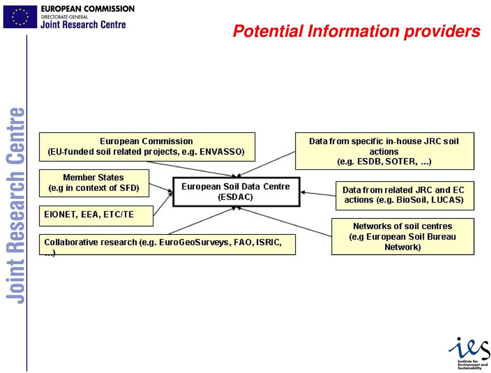
7 Inventory JRC ESTAT EEA, EIONET, ETC/TE EC Member States European Soil Regions Soil regions of Europe (scale 1:5,000,000) European Soil Database (ESDB) and derived products PESERA OCTOP Various datasets at 1:250,000 Various soil profile datasets (point data) European Digital Archive of Soil Maps (EuDASM) Forest Focus, BioSoil SINFO Soil data from LUCAS project Soil geometry and attribute data for Eurasia obtained through harmonization of national soil data (scale 1:1,000,000) Soil erosion map for Europe (1k cells) Organic Carbon map for Europe (1k cells) Italy, Albania, Odra basin, Meuse basin Soil Profile Analytical Databases for Europe (SPADE), Danube basin Archive of >5000 scanned soil related maps for all continents. Forest soil (point )data Data on progress in management of contaminated sites for EU ESDB data expanded for the Crop Growth Monitoring System (CGMS) Compiled data related to the following indicators: Soil sealing, Diffuse contamination ( Heavy metal accumulation and Sewage sludge application ), Soil erosion Data from various EC funded soil related projects (e.g. ENVASSO (Environmental Assessment of soil for monitoring)) Currently : existing soil data documented in EUR Reports "Soil Resources in Europe" Future : possibly risk area data for major soil threats identified in context of Soil Thematic Strategy and Soil Framework Directive 7
, Danube basin Archive of >5000 scanned soil related maps for all continents.")
8 Inventory metadata example Title Subject Keywords Publisher Status Description Datasource Type Format Coverage Scale/Resolution Frequence of Updates The ESDBv2 Raster Library - 1km x 1km Prepared raster images for 73 soil attributes of the European Soil Database v2.0 (ESDBv2) Soil, Raster, Grid, SGDBE, Soil Geographical Database, PTRDB, Pedotransfer Rules Database, LAEA, INSPIRE European Commission DG JRC and European Soil Bureau Network Final The library contains raster (or grid) data files (in native ESRI GRID format) for most attributes (73 in total) of the SGDBE and PTRDB databases of the ESDB v2.0; cell sizes are 1km x 1km and the grid is aligned with the reference grid recommended during the 1st Workshop on European Reference Grids in the context of the INSPIRE (Infrastructure for Spatial Information in Europe) initiative.. European Soil Databasev2.0 Rasters (grids) ESRI GRID The grid origin is defined ,0 m west of the projection centre point (52N, 10 E), and ,0 m south of projection centre point (52N 10 E). The grid extent is such that it covers all EU25 countries. Width : ,0 m ; Height : ,0 m ; 7500 columns, 5500 rows. Cell sizes of 1km x 1km One time effort Last update April 2006 Contact Marc Van Liedekerke ([email protected]), JRC Rights / Accessibility Free for download after registration URL 8
 data files (in native ESRI GRID format) for most attributes (73 in total) of the SGDBE and PTRDB databases of the ESDB v2.")
9 ESDAC Repository 9
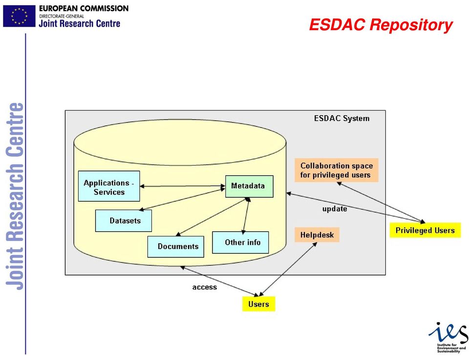
10 ESDAC Repository - precursor European Soil Portal ( is pre-cursor of the ESDAC Repository It operates already a soil data and information service It makes available: data (mainly products derived from the European Soil Database) ; documents (written in the context of JRC institutional work, many in collaboration with ESBN partners) ; applications (web mapping applications that use available soil data); scanned maps (archive of soil-related maps); Help Desk operated for data distribution and problem solving Download of data: anonymous for some data; other data are protected and access is subject to registration ; User base : 600+ users have been registered for 5 large datasets. Communication with User Base: Mailing list, free subscription Regular mails for communication of updates 10
; Help Desk operated for data distribution and problem solving Download of data: anonymous for some data; other data are protected and access is subject to registration ; User base")
11 ESDAC Repository example Link to 11
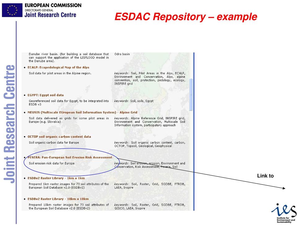
12 ESDAC Repository example This page links then to a page for further download of the data 12

13 ESDAC Implementation For the period , an implementation plan has been proposed by JRC; comments from DG ENV, EEA and ESTAT have been integrated stating that : ESDAC will become the single focal point for policy relevant soil data and information at EU level by hosting relevant EU soil products and by providing web-based tools for the access to and the update of information located at the ESDAC ESDAC will be based on the extensive experience gained by the JRC in establishing a functional system of soil data and information in support of European policy requirements will allow for the incorporation of information from National and Regional soil data providers fully complying with the INSPIRE principle of delocalized data systems in a networked approach European views for various content aspects of soil (like functional maps for Europe) will be produced by JRC/EEA and quality-controlled and hosted in the ESDAC 13

14 ESDAC Implementation According to a number of principles (1): Report or submit data once (to a central place) and use many ; use of harmonised data reporting tools ESDAC will integrate with State-of-the-Environment (SoE) work for Europe and be compliant with future EU soil protection legislation (and where appropriate other) reporting data flows. ESDAC will be one node in a system consisting of distributed data nodes: as a soil data node, it will hold soil data at European level, while other soil data nodes at regional, national or global level will focus on data of different scales. Users can build own services and connect their data to ESDAC or access ESDAC data (interoperability) 14

15 ESDAC Implementation More principles (2): ESDAC will develop in close relationship to the INSPIRE Directive and will be integrated into the broader context of spatial information sharing Environmental Data should be stored at different nodes and information should be shared between all participating nodes. For the sake of information sharing and exchange all participating nodes have to be interoperable, data should be exchangeable and services should be able to access and process data from different nodes. Data should be maintained at the most appropriate level and shared between all other levels. (subsidiarity) It should be possible to discover easily data and services. Users should be able to determine data s fitness for use and the conditions of usage should be clearly described. 15
 It should be possible to discover easily data and services.")
16 ESDAC Implementation More principles (3): ESDAC major tasks will be the collection and interpretation of data and information needs, the subsequent collection and compilation of data, checking and improving of data quality and making data available to the users. Additionally,when required, it will also perform assessments of the stored data and information. ESDAC will be in principle decentralized, meaning that aggregated data and information will reside physically on ESDAC servers located at the JRC, while the original data will stay with the data owner. Provisions will be made so that soil data products, which may be accessed elsewhere, will be visible in the ESDAC through its metadata. Quality control of the original data is under responsibility of the data provider; if ESDAC intends to aggregate such data in value-added products, it will conduct an additional quality check in line with its QA/QC policies. The user access policy will be aligned with Go4 developments related to the DC common architecture, the SEIS and INSPIRE. 16

17 ESDAC Implementation More principles (4): In order to be interoperable with other emerging services, metadata will be created according to a metadata model in line with agreed international standards and possible applications will be developed as interoperable as possible. The ESDAC will be as open as legally possible, meaning that if data and information resident in the ESDAC can legally be published, the system will do. Even when a product is protected for access by only privileged users, efforts will be made in order to present its metadata to the user. In the future, ESDAC could become one soil data centre in a group of cooperating soil data centres including the World Soil Data Centre (ISRIC), National Soil Data Centres (at Member State level) and Regional Soil Data providers, providing policy relevant soil information for different scales. The ESDAC will adapt in order to be interoperable with these centres. 17

18 ESDAC development Preparation phase (2006) JRC defined the ESDAC to the largest possible extent and compiled an inventory of its soil data holdings and other European and national level soil data held at JRC, other DG s of the European Commission and EEA. The technical component of ESDAC was defined in relation to the current soil data and information service that the JRC LMNH Unit is operating through the European Soil Portal (eusoils.jrc.it); Collaboration for soil isues at European level: Collaboration Agreement with the World Data Centre for Soil (at ISRIC) MoU with FAO prepared MoU between JRC and EuroGeoSurveys has been signed A framework contract for soil data provision is under preparation to allow the JRC to acquire in a flexible manner soil data from a consortium of soil data providers. 18
; Collaboration for soil isues at European level: Collaboration Agreement with the World Data Centre for Soil (at ISRIC) MoU with FAO prepared MoU between JRC and EuroGeoSurveys has been signed A")
19 ESDAC development Construction phase ( ) - implementation of the ESDAC technical platform - population of ESDAC with currently available data and information - integration in ESDAC of BioSoil and other future data elaborated by JRC - integration of LUCAS data (developed by Eurostat) - collection of requirements for new data and information from DG ENV; organization of data collection and integration in ESDAC - definition of a mechanism for the transfer of results (data and information) from soil related EU projects to ESDAC (with DG ENV and DG RTD) - definition of the working link between EEA and ESDAC in relation to contaminated land/sites (collection of requirements for new data and information from EEA; SoE Report requirements, paneuropean requirements) - implementation of the collaboration with ISRIC, FAO and EuroGeoSurveys - development of a system to host data reported by Member States, in relation to the soil FWD - if specifically required by DG ENV: European reporting to international conventions 19
 - implementation of")
20 ESDAC development ESDAC technical platform: Before the end of 2007: Improved version of the current repository at eusoils.jrc.it Based on ISO metadata standard for spatial data (supported by INSPIRE) Using existing spatial data metadata catalogue software (KonTerra) Search 1 catalogue During 2008: Extension of the 2007 version in order to inter-operate with other catalogues, based on software which is already under development at LMNH unit Search multiple catalogues 20
 Search 1 catalogue During 2008: Extension of the 2007 version in order to inter-operate")
21 ESDAC development No. Data origin Responsible Go4 partner Timetable for inclusion 1 JRC in-house data/info JRC Already available 2 BioSoil data JRC End LUCAS JRC/ESTAT From 2007, as data become available 4 Data and information elaborated for DG ENV JRC Elaboration during 2007; integration during 2008 and Data and information from EU projects JRC From 2007, as results become available. 6 Data from EEA JRC/EEA From 2007, as data become available. 7 Data stemming from collaboration with Word Data Centre for Soil 8 Data stemming from collaboration with FAO 9 Data stemming from collaboration with EuroGeoSurveys JRC 2008 JRC 2008 JRC
22 ESDAC and other Go4 data centres Common Web Portal Functionalities to assure Interoperabilty EFDAC ESDAC M Metadata M Metadata D Data repository D Data repository A -Derived datasets -Integr. Assessment -Scenario modeling -Graphs, maps A -Derived datasets -Integr. Assessment -Scenario modeling -Graphs, maps M M M M M P GMES RTD M M M M M P GMES RTD 22
23 ESDAC and other Go4 data centres Common web portal Common access point for users searching and viewing information distributed in different DCs What will be included? Integrated Catalog of Metadata - Harvested metadata collected and maintained by various DC - Direct hosting of metadata (if a DC is not managing its own catalog) Discovery services (search data using keywords, themes, geographical extent, geo-location) View services (view data stored in different DC and partners) 23
24 ICSU/ISRIC/FAO/UNEP ESDAC and other soil data centres Data centers providing policy relevant soil information for different scales 1:5,000,000 World Data Centre for Soil (WDC Soil) Operated by ISRIC on behalf of ICSU EU Member States Regions 1:1,000,000 European Soil Data Centre (ESDAC) Operated by JRC National Soil Data Centre to be defined Regional Soil Data Centre to be defined Communes Soil Monitoring Sites 24
The European Soil Data Center 欧 洲 土 壤 数 据 中 心
 The European Soil Data Center 欧 洲 土 壤 数 据 中 心 Gergely Tóth, Panos Panagos, Marc van Liedekerke,, Luca Montanarella EUROPEAN COMMISSION JOINT RESEARCH CENTRE Institute for Environment and Sustainability
JOINT RESEARCH CENTER. European Forest Data Center (EFDAC)
") Institute for Environment and Sustainability 1 JOINT RESEARCH CENTER European Forest Data Center (EFDAC) Gerimantas Gaigalas [email protected] BACKGROUND Institute for Environment and Sustainability
Institute for Environment and Sustainability 1 JOINT RESEARCH CENTER European Forest Data Center (EFDAC) Gerimantas Gaigalas [email protected] BACKGROUND Institute for Environment and Sustainability
JRC on 9 November 2009 Biosoil Conference 1. http://forest.jrc.ec.europa.eu/
 JRC on 9 November 2009 Biosoil Conference 1 The European Forest Data Centre (EFDAC) Jesús San-Miguel-Ayanz http://forest.jrc.ec.europa.eu/ Outline FOREST Action 2 1. Role of the European Commission Joint
Knowledge innovation project (KIP) on Accounting for natural capital and ecosystem services - scoping paper Public version 22 June 2015
 on Accounting for natural capital and ecosystem services - scoping paper Public version 22 June 2015") Knowledge innovation project (KIP) on Accounting for natural capital and ecosystem services - scoping paper Public version 22 June 2015 Abstract Establishing a sound method of natural capital accounting
Knowledge innovation project (KIP) on Accounting for natural capital and ecosystem services - scoping paper Public version 22 June 2015 Abstract Establishing a sound method of natural capital accounting
Guidelines for filling in the Excel Template for Monitoring INSPIRE by the contributing authorities
 Guidelines for filling in the Excel Template for Monitoring INSPIRE by the contributing authorities WARNING: in order to allow for an automated upload into the data base it is necessary that strict formatting
An Esri White Paper June 2011 ArcGIS for INSPIRE
 An Esri White Paper June 2011 ArcGIS for INSPIRE Esri, 380 New York St., Redlands, CA 92373-8100 USA TEL 909-793-2853 FAX 909-793-5953 E-MAIL [email protected] WEB esri.com Copyright 2011 Esri All rights reserved.
Guidance for Reporting under the Floods Directive (2007/60/EC)
") Technical Report - 2013-071 Guidance for Reporting under the Floods Directive Guidance Document No. 29 A compilation of reporting sheets adopted by Water Directors Common Implementation Strategy for the
Technical Report - 2013-071 Guidance for Reporting under the Floods Directive Guidance Document No. 29 A compilation of reporting sheets adopted by Water Directors Common Implementation Strategy for the
Provisional European Soil Data
 Provisional European Soil Data Infrastructure the GS Soil approach Katharina Feiden (PortalU, project coordination) Presented by Rainer Baritz (WP 4 leader) Federal Institute for Geosciences and Natural
European Forest Information and Communication Platform
 1 Metadata Model for the European Forest Information and Communication Platform D. Tilsner 1, C. Figueiredo 1, H. Silva 2, B. Chartier 3, J. San-Miguel 4, A. Camia 4, M. Millot 4 1 EDISOFT, S.A., Lisbon,
The Biodiversity Information System for Europe - BISE -
 The Biodiversity Information System for Europe - BISE - Sabine Roscher Dominique Richard European Topic Centre Biological Diversity (ETC/BD) Meeting of the Group of experts on Protected Areas and ecological
ProSUM Prospecting Secondary raw materials in the Urban mine and Mining wastes
 ProSUM Prospecting Secondary raw materials in the Urban mine and Mining wastes Background Project Summary The use of secondary raw materials and recycling was recommended to the European Commission as
CDI/THREDDS Interoperability: the SeaDataNet developments. P. Mazzetti 1,2, S. Nativi 1,2, 1. CNR-IMAA; 2. PIN-UNIFI
 CDI/THREDDS Interoperability: the SeaDataNet developments P. Mazzetti 1,2, S. Nativi 1,2, 1. CNR-IMAA; 2. PIN-UNIFI Outline Interoperability Issues in SeaDataNet A broker solution for CDI/THREDDS interoperability
Metadata for Data Discovery: The NERC Data Catalogue Service. Steve Donegan
 Metadata for Data Discovery: The NERC Data Catalogue Service Steve Donegan Introduction NERC, Science and Data Centres NERC Discovery Metadata The Data Catalogue Service NERC Data Services Case study:
A. Document repository services for EU policy support
 A. Document repository services for EU policy support 1. CONTEXT Type of Action Type of Activity Service in charge Associated Services Project Reusable generic tools DG DIGIT Policy DGs (e.g. FP7 DGs,
Description of the table of the in-situ data requirements of GMES services
 Description of the table of the in-situ data requirements of GMES services 1. In-situ data requirement: Contains short description of each in-situ data (including spatial data) requirement defined by GMES
 European Forest Data Centre Biosoil/Biodiversity Forest Type Map 2006 P. Kempeneers, JRC T. Durant F. Sedano, JRC L. Seebach, JRC J. San-Miguel-Ayanz, JRC EC -, IES Land Management and Natural Hazard Unit
The Role of Spatial Data in EU Agricultural Policy Analysis
 The Role of Spatial Data in EU Agricultural Policy Analysis Wolfgang Britz Institute for Food and Resource Economics, University Bonn Geospatial Open Source Hosting of Agriculture, Resource and Environmental
How To Write An Inspire Directive
 INSPIRE Infrastructure for Spatial Information in Europe Detailed definitions on the INSPIRE Network Services Title Detailed definitions on the INSPIRE Network Services Creator Date 2005-07-22 Subject
PDOK Kaart, the Dutch Mapping API
 PDOK Kaart, the Dutch Mapping API Haico van der Vegt*, Leo van der Sluijs* * Cadastre, Land Registry and Mapping Agency of the Netherlands Abstract. PDOK (public services on the map) is a partnership of
How To Use The Alabama Data Portal
 113 The Alabama Metadata Portal: http://portal.gsa.state.al.us By Philip T. Patterson Geological Survey of Alabama 420 Hackberry Lane P.O. Box 869999 Tuscaloosa, AL 35468-6999 Telephone: (205) 247-3611
ArcGIS Data Models Practical Templates for Implementing GIS Projects
 ArcGIS Data Models Practical Templates for Implementing GIS Projects GIS Database Design According to C.J. Date (1995), database design deals with the logical representation of data in a database. The
EXPLORING AND SHARING GEOSPATIAL INFORMATION THROUGH MYGDI EXPLORER
 EXPLORING AND SHARING GEOSPATIAL INFORMATION THROUGH MYGDI EXPLORER Subashini Panchanathan Malaysian Centre For Geospatial Data Infrastructure ( MaCGDI ) Ministry of National Resources and Environment
MyOcean Copernicus Marine Service Architecture and data access Experience
 MyOcean Copernicus Marine Service Architecture and data access Experience Sophie Besnard CLS, Toulouse, France February 2015 MyOcean Story MyOcean Challenge & Success MyOcean Service MyOcean System MyOcean
REACCH PNA Data Management Plan
 REACCH PNA Data Management Plan Regional Approaches to Climate Change (REACCH) For Pacific Northwest Agriculture 875 Perimeter Drive MS 2339 Moscow, ID 83844-2339 http://www.reacchpna.org [email protected]
GIS Data Models for INSPIRE and ELF
 GIS Data Models for INSPIRE and ELF Paul Hardy Roberto Lucchi EuroSDR/ELF Copenhagen Data Modelling and Model Driven Implementation of Data Distribution 28 Jan 2015 ArcGIS for INSPIRE Extends ArcGIS for
Enabling embedded maps
 Enabling embedded maps Case: National geoportal of Finland Antti Rainio National Land Survey of Finland Trends: Web Services, Mapping Mashup, Open Source, Open Data Decentralised data s Service interfaces
EUROPEAN UNION RAW MATERIALS KNOWLEDGE BASE (EURMKB) first steps
 first steps") EUROPEAN UNION RAW MATERIALS KNOWLEDGE BASE (EURMKB) first steps Workshop on Best practices on mining policies and technologies 12-13 June 2014, Brussels Slavko SOLAR, Claudia WULZ European Commission,
EUROPEAN UNION RAW MATERIALS KNOWLEDGE BASE (EURMKB) first steps Workshop on Best practices on mining policies and technologies 12-13 June 2014, Brussels Slavko SOLAR, Claudia WULZ European Commission,
JRC and GMES GIO-EMS
 Joint Research Centre JRC and GMES GIO-EMS Guido Lemoine, Jan Kucera, Marco Broglia JRC, Ispra 1st GMES NATIONAL USER FORUM DAY Prague, 29-30 May 2012 Serving society Stimulating innovation Supporting
GIS Initiative: Developing an atmospheric data model for GIS. Olga Wilhelmi (ESIG), Jennifer Boehnert (RAP/ESIG) and Terri Betancourt (RAP)
, Jennifer Boehnert (RAP/ESIG) and Terri Betancourt (RAP)") GIS Initiative: Developing an atmospheric data model for GIS Olga Wilhelmi (ESIG), Jennifer Boehnert (RAP/ESIG) and Terri Betancourt (RAP) Unidata seminar August 30, 2004 Presentation Outline Overview
GIS Initiative: Developing an atmospheric data model for GIS Olga Wilhelmi (ESIG), Jennifer Boehnert (RAP/ESIG) and Terri Betancourt (RAP) Unidata seminar August 30, 2004 Presentation Outline Overview
INSPIRE Dashboard. Technical scenario
 INSPIRE Dashboard Technical scenario Technical scenarios #1 : GeoNetwork catalogue (include CSW harvester) + custom dashboard #2 : SOLR + Banana dashboard + CSW harvester #3 : EU GeoPortal +? #4 :? + EEA
EFAS European Flood Awareness System
 EFAS European Flood Awareness System http://www.efas.eu/ EFAS Partner Network The first operational hydrological network in Europe Cristina Alionte Eklund Coordinator EFAS Dissemination Center History
Databases & Data Infrastructure. Kerstin Lehnert
 + Databases & Data Infrastructure Kerstin Lehnert + Access to Data is Needed 2 to allow verification of research results to allow re-use of data + The road to reuse is perilous (1) 3 Accessibility Discovery,
Origins and causes of river basin sediment degradation and available remediation and mitigation options. Feedback from the Riskbase workshop
 Origins and causes of river basin sediment degradation and available remediation and mitigation options Feedback from the Riskbase workshop Corinne Merly 1, Olivier Cerdan 1, Laurence Gourcy 1 Emmanuelle
Data access and management
 B Data access and management CONTENTS B.1 Introduction... B-1 B.2 Data requirements and availability... B-1 B.3 Data access... B-2 B.4 Overall procedures... B-2 B.5 Data tools and management... B-4 Appendix
UK Location Programme
 Location Information Interoperability Board Data Publisher How To Guide Understand the background to establishing an INSPIRE View Service using GeoServer DOCUMENT CONTROL Change Summary Version Date Author/Editor
COMMISSION STAFF WORKING DOCUMENT. Elements of the Union greenhouse gas inventory system and the Quality Assurance and Control (QA/QC) programme
 programme") EUROPEAN COMMISSION Brussels, 12.8.2013 SWD(2013) 308 final COMMISSION STAFF WORKING DOCUMENT Elements of the Union greenhouse gas inventory system and the Quality Assurance and Control (QA/QC) programme
EUROPEAN COMMISSION Brussels, 12.8.2013 SWD(2013) 308 final COMMISSION STAFF WORKING DOCUMENT Elements of the Union greenhouse gas inventory system and the Quality Assurance and Control (QA/QC) programme
Emergency Management Service. early warning FLOOD AND FIRE ALERTS. Space
 Emergency Management Service early warning FLOOD AND FIRE ALERTS Space 1 Copernicus at a Glance Copernicus is the European Union s Earth Observation programme: a user-driven space programme under civil
Nevada NSF EPSCoR Track 1 Data Management Plan
 Nevada NSF EPSCoR Track 1 Data Management Plan August 1, 2011 INTRODUCTION Our data management plan is driven by the overall project goals and aims to ensure that the following are achieved: Assure that
MONITORING OF HABITATS AT THE LEVEL OF A NATURA 2000 SITE MOHANA MOBILE AND WEB APP. Francisco Gutierres 1. May of 2016
 MONITORING OF HABITATS AT THE LEVEL OF A NATURA 2000 SITE MOHANA MOBILE AND WEB APP Francisco Gutierres 1 May of 2016 1 Ph.D. in Physical Geography, Institute of Geography Spatial Planning of the University
The Nordic way to International standardization ISO/TC 211
 «Think Local - Act Global» Why engagement in international standards development is important A Nordic Perspective The Nordic way to International standardization Olaf Magnus Østensen Chair of Norway SOSI
HydroDesktop Overview
 HydroDesktop Overview 1. Initial Objectives HydroDesktop (formerly referred to as HIS Desktop) is a new component of the HIS project intended to address the problem of how to obtain, organize and manage
ArcGIS Online School Locator
 ArcGIS Online School Locator G-Cloud Services RM 1557vi Service Definition Esri UK G-Cloud 6 Lot 3 SaaS Services Crown Commercial Service Acknowledgement Esri and ArcGIS are trademarks, registered trademarks,
Sextant. Spatial Data Infrastructure for Marine Environment. C. Satra Le Bris, E. Quimbert, M. Treguer
 Sextant On-Line information system for marine geographical information E. Quimbert, M. Bellouis, F. Lecuy, M. Treguer Centre de Bretagne BP 70, Plouzané 29280 France E-mail: [email protected] Sextant
SeaDataNet pan-european infrastructure for ocean and marine data management. Dick M.A. Schaap MARIS
 SeaDataNet pan-european infrastructure for ocean and marine data management By Dick M.A. Schaap MARIS SeaDataNet II Technical Coordinator Co-authors: Michele Fichaut (Ifremer) and Giuseppe Manzella (ENEA)
Pan-European infrastructure for management of marine and ocean geological and geophysical data
 Pan-European infrastructure for management of marine and ocean geological and geophysical data By Dick M.A. Schaap Geo-Seas Technical Coordinator March 2010 Supported by the European Commission FP7 - Research
Primary author: Kaspar, Frank (DWD - Deutscher Wetterdienst), [email protected]
, Frank.Kaspar@dwd.de") Primary author: Kaspar, Frank (DWD - Deutscher Wetterdienst), [email protected] Co-authors: Johannes Behrendt (DWD - Deutscher Wetterdienst), Klaus-Jürgen Schreiber (DWD - Deutscher Wetterdienst) Abstract
Primary author: Kaspar, Frank (DWD - Deutscher Wetterdienst), [email protected] Co-authors: Johannes Behrendt (DWD - Deutscher Wetterdienst), Klaus-Jürgen Schreiber (DWD - Deutscher Wetterdienst) Abstract
Geoscientific spatial data
 SDIC European Sustainable Development related policies and legislation INSPIRE and geoscientific data P. Christmann, K. Asch, Rafaelle Pignone, I. Jackson, F. Robida, P. Ryghaug, R. Tomas, L. Persson,
NATIONAL CLIMATE CHANGE & WILDLIFE SCIENCE CENTER & CLIMATE SCIENCE CENTERS DATA MANAGEMENT PLAN GUIDANCE
 NATIONAL CLIMATE CHANGE & WILDLIFE SCIENCE CENTER & CLIMATE SCIENCE CENTERS DATA MANAGEMENT PLAN GUIDANCE Prepared by: NCCWSC/CSC Data Management Working Group US Geological Survey February 26, 2013 Version
Air Pollution. Copenhagen, 3 rd September 2014. Valentin Foltescu Project manager air quality European Environment Agency
 Air Pollution Copenhagen, 3 rd September 2014 Valentin Foltescu Project manager air quality European Environment Agency Air pollution, transport and noise MAWP Strategic Area 1.1 Objective To support and
Building a SDI for small countries the Portuguese example
 Building a SDI for small countries the Portuguese example Rui Pedro Julião Instituto Geográfico Português Deputy Director-General [email protected] Abstract Portugal was one of the SDI pioneers in the beginning
Standard 5: Use a consistent data management framework in accordance with internal and partner organization data standards.
 Standard 5: Use a consistent data management framework in accordance with internal and partner organization data standards. [conceptualize]1 Rationale Establishing and using a consistent data management
General concepts: DDI
 General concepts: DDI Irena Vipavc Brvar, ADP SEEDS Kick-off meeting, Lausanne, 4. - 6. May 2015 How to describe our survey What we learned so far: If we want to use data at some point in the future,
Norwegian Satellite Earth Observation Database for Marine and Polar Research http://normap.nersc.no USE CASES
 Norwegian Satellite Earth Observation Database for Marine and Polar Research http://normap.nersc.no USE CASES The NORMAP Project team has prepared this document to present functionality of the NORMAP portal.
Cadastre in the context of SDI and INSPIRE
 Cadastre in the context of SDI and INSPIRE Dr. Markus Seifert Bavarian Administration for Surveying and Cadastre Cadastre in the digital age the approach in Germany 3 rd CLGE Conference, Hanover, 11.10.2012
GeoNetwork User Manual
 GeoNetwork User Manual Release 2.10.4-0 GeoNetwork July 06, 2015 Contents 1 Preface 3 1.1 About this Project..................................... 3 1.2 License Information....................................
INSPIRE INfrastructure for SPatial InfoRmation in Europe
 INSPIRE INfrastructure for SPatial InfoRmation in Europe Realisation Aspects at BEV in Austria Dr. techn. Markus Jobst Team INSPIRE/BEV Agenda INSPIRE common understanding at BEV/AT Infrastructure Framework
SeaDataNet pan-european infrastructure for ocean and marine data management and its relation to EMODNet and GEOSS
 SeaDataNet pan-european infrastructure for ocean and marine data management and its relation to EMODNet and GEOSS By Dick M.A. Schaap MARIS SeaDataNet Technical Coordinator Madrid Spain, 26 January 2012,
Portal Version 1 - User Manual
 Portal Version 1 - User Manual V1.0 March 2016 Portal Version 1 User Manual V1.0 07. March 2016 Table of Contents 1 Introduction... 4 1.1 Purpose of the Document... 4 1.2 Reference Documents... 4 1.3 Terminology...
African European Georesources Observation System
 African European Georesources Observation System Spatial Data Infrastructure (SDI) Dr. Andreas Barth, Bernd Torchala Beak, Germany Outline Project Overview AEGOS SDI data / services hardware / software
DISMAR implementing an OpenGIS compliant Marine Information Management System
 DISMAR implementing an OpenGIS compliant Marine Information Management System Éamonn Ó T uama, Coastal & Marine Resources Centre, ERI, University College Cork. DISMAR DISMAR (Data Integration System for
How To Write An Nccwsc/Csc Data Management Plan
 Guidance and Requirements for NCCWSC/CSC Plans (Required for NCCWSC and CSC Proposals and Funded Projects) Prepared by the CSC/NCCWSC Working Group Emily Fort, Data and IT Manager for the National Climate
EUROPEAN COMMISSION. Better Regulation "Toolbox" This Toolbox complements the Better Regulation Guideline presented in in SWD(2015) 111
 111") EUROPEAN COMMISSION Better Regulation "Toolbox" This Toolbox complements the Better Regulation Guideline presented in in SWD(2015) 111 It is presented here in the form of a single document and structured
EUROPEAN COMMISSION Better Regulation "Toolbox" This Toolbox complements the Better Regulation Guideline presented in in SWD(2015) 111 It is presented here in the form of a single document and structured
7th Framework Programme Theme 6 Environment (including climate change)
") 7th Framework Programme Theme 6 Environment (including climate change) «Environnement» et «Énergie» Programme D. Deybe DG RTD Environment Directorate 1 Cooperation Collaborative Research Ten themes 1.
7th Framework Programme Theme 6 Environment (including climate change) «Environnement» et «Énergie» Programme D. Deybe DG RTD Environment Directorate 1 Cooperation Collaborative Research Ten themes 1.
Spatial Data Infrastructure. A Collaborative Network
 Spatial Data Infrastructure A Collaborative Network Solving Challenges Takes Collaboration Social challenges, environmental issues, and economic downturns all take cooperation to solve. Working together
Cookbook 23 September 2013 GIS Analysis Part 1 - A GIS is NOT a Map!
 Cookbook 23 September 2013 GIS Analysis Part 1 - A GIS is NOT a Map! Overview 1. A GIS is NOT a Map! 2. How does a GIS handle its data? Data Formats! GARP 0344 (Fall 2013) Page 1 Dr. Carsten Braun 1) A
Local Loading. The OCUL, Scholars Portal, and Publisher Relationship
 Local Loading Scholars)Portal)has)successfully)maintained)relationships)with)publishers)for)over)a)decade)and)continues) to)attract)new)publishers)that)recognize)both)the)competitive)advantage)of)perpetual)access)through)
THE EUROPEAN DATA PORTAL
 European Public Sector Information Platform Topic Report No. 2016/03 UNDERSTANDING THE EUROPEAN DATA PORTAL Published: February 2016 1 Table of Contents Keywords... 3 Abstract/ Executive Summary... 3 Introduction...
Data Harmonization and Management System for the Institute for Prospective Technological Studies
 Data Harmonization and Management System for the Institute for Prospective Technological Studies Customer profile Research Centre (JRC). Its mission is to provide customer-driven support to the EU policy-making
Building up a SDI What is needed? Ulla Kronborg Mazzoli Danish ministry for the Environment National Survey and Cadastre
 Building up a SDI What is needed? Ulla Kronborg Mazzoli Danish ministry for the Environment National Survey and Cadastre He who knows all the answers has not yet been asked all the questions. - Author
DATA QUALITY AND SCALE IN CONTEXT OF EUROPEAN SPATIAL DATA HARMONISATION
 DATA QUALITY AND SCALE IN CONTEXT OF EUROPEAN SPATIAL DATA HARMONISATION Katalin Tóth, Vanda Nunes de Lima European Commission Joint Research Centre, Ispra, Italy ABSTRACT The proposal for the INSPIRE
ICCD/COP(12)/CST/INF.5
/CST/INF.5") United Nations Convention to Combat Desertification ICCD/COP(12)/CST/INF.5 Distr.: General 13 August 2015 English only Conference of the Parties Committee on Science and Technology Twelfth session Ankara,
United Nations Convention to Combat Desertification ICCD/COP(12)/CST/INF.5 Distr.: General 13 August 2015 English only Conference of the Parties Committee on Science and Technology Twelfth session Ankara,
INTERNATIONAL CONFERENCE: SDI & SIM 2013. Spatial Data Infrastructures & Spatial Information Management 2013
 INTERNATIONAL CONFERENCE: Spatial Data Infrastructures & Spatial Information Management 2013 And Commission 3 Annual Meeting The 2013 Annual 'FIG Commission 3' Workshop and Meeting is joined by the 'FIG
Learn about OverDrive APIs and how they can benefit search, discovery and reporting services at your library. Contact: training@overdrive.
 v.10012010 v.10042013 v.11012010 OverDrive, Inc. 2010 2013 Page 1 1 OverDrive APIs Learn about OverDrive APIs and how they can benefit search, discovery and reporting services at your library. Contact:
Product Navigator User Guide
 Product Navigator User Guide Table of Contents Contents About the Product Navigator... 1 Browser support and settings... 2 Searching in detail... 3 Simple Search... 3 Extended Search... 4 Browse By Theme...