Australia s National Carbon Accounting System. Dr Gary Richards Director and Principal Scientist
|
|
|
- Marianna Andrews
- 9 years ago
- Views:
Transcription
1 Australia s National Carbon Accounting System Dr Gary Richards Director and Principal Scientist

2

3 Government Commitment The Australian Government has committed to a 10 year, 3 phase, ~$35M program for a national, comprehensive (all pools, gases and processes) and integrated (mass balance, process driven) capability to: account for all land based emissions (C & N) singular multi-scale (bottom-up) project to national sub-hectare monthly reporting provide projections and scenario capability
 project to national sub-hectare monthly reporting provide projections and scenario")
4 Ten Year 3 Stage Plan Phase 1 ( ) Establish comprehensive framework Provide Land Use Change 1990 baseline primarily CO2 Transitional ( ) Consolidate Phase 1 Development Activities for Phase 2 (particularly n-cycle) Phase 2 ( ) Develop comprehensive capability (all pools, gases and activities) Public tools and data dissemination
 Public tools and data")
5 Key Characteristics Centralised and integrated national programs to support a spatially based, mass balance process model (FullCAM) Based around CO2Fix, RothC, Gendec, Century, 3PG, Gorcam, Boundary Line, Founded on key national datasets 13 Landsat coverages Monthly climate surfaces Physical inventories Land management, land use data

6 Implementation Critical mass and coordination Remote sensing at < 20% of benchmark costs Structured programs for verification, continuous improvement and uncertainty management Systems of relationships for data and human resources Focus on extending applications and therefore partnerships Public accessibility to support individual action

7 Barriers Data availability Model capability Systems and business models Skills technical and administrative Governance issues largely around whole of government support and usage

8 National Carbon Accounting System the process

9 Time Series Change (02 backdrop)

10 Forest Conversion 1995 conversion 2000

11 Resource Inventory (eg Soil Carbon) Initial Soil C inventory from available data

12 Climate (eg Rainfall)

13 Average Temperature

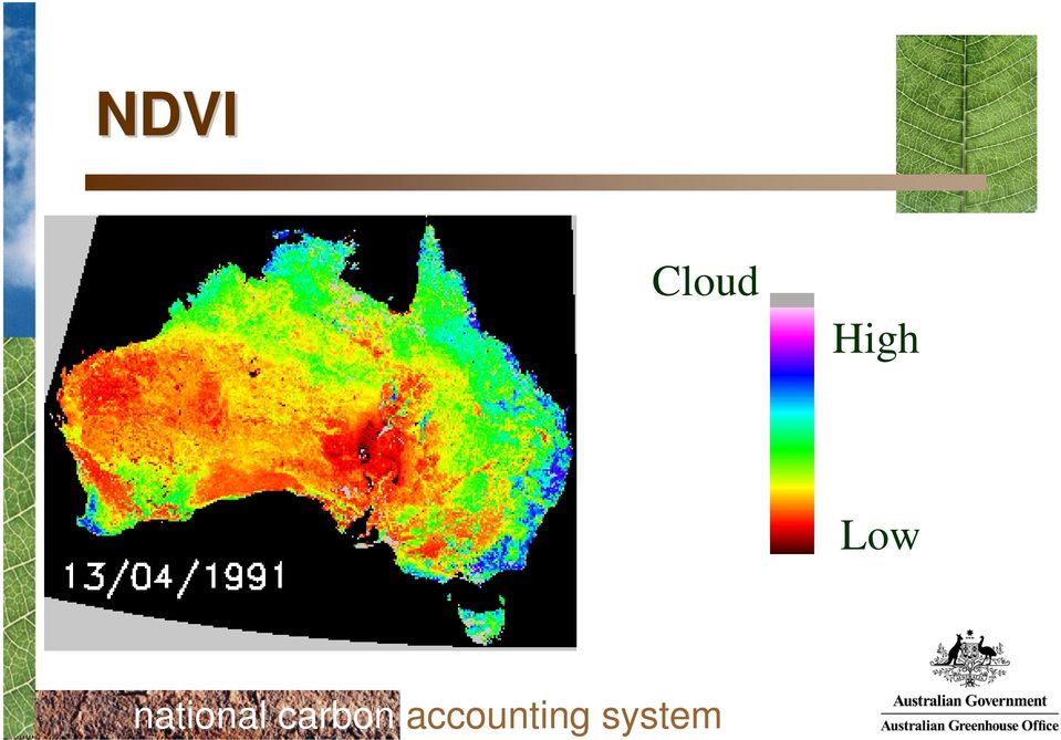
14 NDVI Cloud High Low
15 Model subroutines (eg Forest Productivity Index)

16 Land Use Currently by regional survey of agricultural and forestry management practices mapped to soil types Proposed move from regional survey to spatially relevant mapping using historic (remote sensing) AVHRR and current MODIS data
 AVHRR and current")
17 Land Use & Management

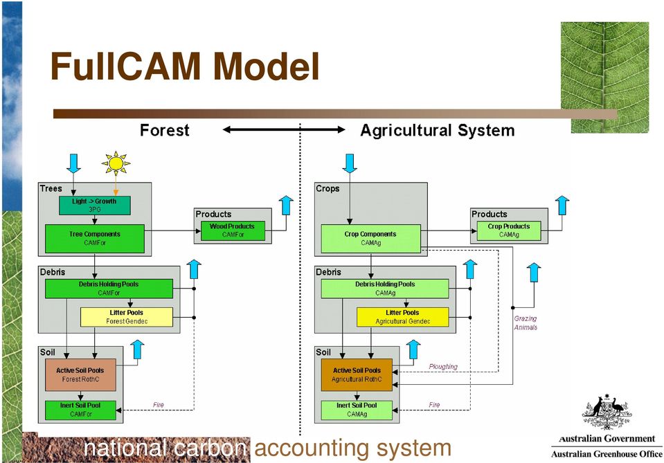
18 FullCAM Model
19 Carbon Stock Change Output

20 Verification Principles Physically measurable Transparent and visible Contribute to continuous improvement Progressively reduce uncertainty Provide input to sensitivity analysis Top-down & bottom-up

21 Remote Sensing - Verification Recent clearing
22 Biomass Verification
23 Soil Model Verification
24 Current Developments a non-co2 national account coupled to current carbon accounts provide a publicly available carbon accounting toolbox representing full NCAS capability further develop the Image Viewer product as the primary vehicle for general dissemination of NCAS data; and provide ready access to the NCAS data library integrate carbon accounting and economic scenarios to provide a sound biophysical and economic basis for greenhouse emissions projections review, maintain and enhance system hardware and software capability and systematize and catalogue the recording and access to data holdings
25 Product Releases Base natural resource and satellite data via Geoscience Australia In 2005 (March): NCAT FullCAM model and webserver and database access to the NCAS data holdings NCAS Technical support documentation in a searchable format Image Viewer vers time series of satellite data Select spatial data Regionalised statistics (natural resource and economic)
5.5 QUALITY ASSURANCE AND QUALITY CONTROL
 0 0 0. QUALITY ASSURANCE AND QUALITY CONTROL.. Introduction The IPCC Good Practice Guidance and Uncertainty Management (GPG000, IPCC, 000), Chapter, Quality Assurance and Quality Control, defines quality
VCS REDD Methodology Module. Methods for monitoring forest cover changes in REDD project activities
 1 VCS REDD Methodology Module Methods for monitoring forest cover changes in REDD project activities Version 1.0 May 2009 I. SCOPE, APPLICABILITY, DATA REQUIREMENT AND OUTPUT PARAMETERS Scope This module
5 day Training on Climate Change and Adaptation
 Training Programme 5 day Training on and Adaptation Developed by: Bangladesh Centre for Advanced Studies (BCAS) [A comprehensive training module along with guideline for trainers aiming to enhance capacity
Using Remote Sensing to Monitor Soil Carbon Sequestration
 Using Remote Sensing to Monitor Soil Carbon Sequestration E. Raymond Hunt, Jr. USDA-ARS Hydrology and Remote Sensing Beltsville Agricultural Research Center Beltsville, Maryland Introduction and Overview
NEW ZEALAND. Submission to the Ad Hoc Working Group on the Durban Platform for Enhanced Action. Work Stream 1 March 2014
 NEW ZEALAND Submission to the Ad Hoc Working Group on the Durban Platform for Enhanced Action Work Stream 1 March 2014 Context This submission responds to the invitation from the Ad Hoc Working Group on
Report of the technical assessment of the proposed forest reference emission level of Brazil submitted in 2014
 United Nations FCCC/TAR/2014/BRA Distr.: General 1 December 2014 English only Report of the technical assessment of the proposed forest reference emission level of Brazil submitted in 2014 Summary This
CDI SSF Category 1: Management, Policy and Standards
 CDI SSF Category 1: Management, Policy and Standards Developing a Data Management Plan for Implementation: Best Practices for the Collection, Management, Storing, and Sharing of Geospatial and Non-geospatial
Improving global data on forest area & change Global Forest Remote Sensing Survey
 Improving global data on forest area & change Global Forest Remote Sensing Survey work by FAO and partners - Adam Gerrand, E. Lindquist, R. D Annunzio, M. Wilkie, FAO, - F. Achard et al. TREES team at
Data Processing Flow Chart
 Legend Start V1 V2 V3 Completed Version 2 Completion date Data Processing Flow Chart Data: Download a) AVHRR: 1981-1999 b) MODIS:2000-2010 c) SPOT : 1998-2002 No Progressing Started Did not start 03/12/12
Data Management Framework for the North American Carbon Program
 Data Management Framework for the North American Carbon Program Bob Cook, Peter Thornton, and the Steering Committee Image courtesy of NASA/GSFC NACP Data Management Planning Workshop New Orleans, LA January
Technical paper. Summary
 UNITED NATIONS Distr. GENERAL FCCC/TP/2009/1 31 May 2009 ENGLISH ONLY Cost of implementing methodologies and monitoring systems relating to estimates of emissions from deforestation and forest degradation,
Data Management for the North American Carbon Program
 Image courtesy of NASA/GSFC Data Management for the North American Carbon Program Bob Cook, Eric Sundquist, Tom Boden,, and Peter Thornton RS in NACP Workshop Missoula, MT August 20, 2004 NACP Data and
Integrated Global Carbon Observations. Beverly Law Prof. Global Change Forest Science Science Chair, AmeriFlux Network Oregon State University
 Integrated Global Carbon Observations Beverly Law Prof. Global Change Forest Science Science Chair, AmeriFlux Network Oregon State University Total Anthropogenic Emissions 2008 Total Anthropogenic CO 2
Review for Introduction to Remote Sensing: Science Concepts and Technology
 Review for Introduction to Remote Sensing: Science Concepts and Technology Ann Johnson Associate Director [email protected] Funded by National Science Foundation Advanced Technological Education program [DUE
National Inventory System
 Regional workshop for the Capacity Development for sustainable national Greenhouse Gas Inventories AFOLU sector (CD-REDD II) Programme National Inventory System Daniela Romano Institute for Environmental
CIESIN Columbia University
 Conference on Climate Change and Official Statistics Oslo, Norway, 14-16 April 2008 The Role of Spatial Data Infrastructure in Integrating Climate Change Information with a Focus on Monitoring Observed
A Guide to Woodland Carbon for Business
 A Guide to Woodland Carbon for Business Contents: 1. Investing in Woodland Carbon: an overview 2. Why Woodland Carbon? 3. How much does it cost? 4. Woodland Carbon Code 5. Woodland Carbon compliance 6.
National and Sub-national Carbon monitoring tools developed at the WHRC
 National and Sub-national Carbon monitoring tools developed at the WHRC Nadine Laporte Woods Hole Research Center A. Baccini, W. Walker, S. Goetz, M. Sun, J. Kellndorfer Kigali, 20 th June 2011 Why measuring
CLIMATE CHANGE & FORESTS; STATUS OF SCIENCE, POLICY & RESEARCH. Prof. Ravindranath Indian Institute of Science Bangalore
 CLIMATE CHANGE & FORESTS; STATUS OF SCIENCE, POLICY & RESEARCH Prof. Ravindranath Indian Institute of Science Bangalore Forests and climate change 1. Deforestation and land use change contribute to CO
Global environmental information Examples of EIS Data sets and applications
 METIER Graduate Training Course n 2 Montpellier - february 2007 Information Management in Environmental Sciences Global environmental information Examples of EIS Data sets and applications Global datasets
INTENDED NATIONALLY DETERMINED CONTRIBUTIONS (INDCs)
") UNITED REPUBLIC OF TANZANIA INTENDED NATIONALLY DETERMINED CONTRIBUTIONS (INDCs) 1. Introduction The United Republic of Tanzania, which comprises of Tanzania Mainland and Zanzibar, brings forth her Intended
UNITED REPUBLIC OF TANZANIA INTENDED NATIONALLY DETERMINED CONTRIBUTIONS (INDCs) 1. Introduction The United Republic of Tanzania, which comprises of Tanzania Mainland and Zanzibar, brings forth her Intended
Forestry Thematic Exploitation Platform Earth Observation Open Science 2.0
 Forestry Thematic Exploitation Platform Earth Observation Open Science 2.0 Tuomas Häme VTT Technical Research of Finland Ltd and the Forestry TEP Team Objective One-stop shop for forestry remote sensing
Scope 1 describes direct greenhouse gas emissions from sources that are owned by or under the direct control of the reporting entity;
 9 Greenhouse Gas Assessment 9.1 Introduction This chapter presents an assessment of the potential greenhouse gas emissions associated with the Simandou Railway and evaluates the significance of these in
Climate Change and Renewable Energy A Perspective from a Measurements Viewpoint
 Climate Change and Renewable Energy A Perspective from a Measurements Viewpoint Regional Workshop on Metrology and Technology Challenges of Climate Change and Renewable Energy Guatemala City, Guatemala
The Greenhouse Gas Protocol
 The Greenhouse Gas Protocol Introduction to the Greenhouse Gas Protocol Corporate Accounting and Reporting Standard The Greenhouse Gas (GHG) Protocol Corporate Accounting and Reporting Standard provides
Technology Implications of an Instrumented Planet presented at IFIP WG 10.4 Workshop on Challenges and Directions in Dependability
 Technology Implications of an Instrumented Planet presented at IFIP WG 10.4 Workshop on Challenges and Directions in Dependability Nick Bowen Colin Harrison IBM June 2008 1 Background Global Technology
Jeongho SEO, Kyeonghak LEE, Raehyun KIM Korea Forest Research Institute. 6~8. Sept. 2007 Kuala Lumpur, Malaysia
 5 th Workshop on GHG Inventory in Asia Jeongho SEO, Kyeonghak LEE, Raehyun KIM Korea Forest Research Institute 6~8. Sept. 2007 Kuala Lumpur, Malaysia Contents 1/ 32 Background 2/ 32 Land Use and Forestry
Time Series Analysis of Remote Sensing Data for Assessing Response to Community Based Rangeland Management
 Time Series Analysis of Remote Sensing Data for Assessing Response to Community Based Rangeland Management Jay Angerer Texas A&M University MOR2 Annual Meeting June, 2013 Research Questions During the
IPCC Support to National GHG Inventories
 Task Force on National Greenhouse Gas Inventories IPCC Support to National GHG Inventories WRI MAPT Workshop 2 December, 2012 Nalin SRIVASTAVA Technical Support Unit, IPCC TFI Contents Who we are: The
Primary author: Kaspar, Frank (DWD - Deutscher Wetterdienst), [email protected]
, Frank.Kaspar@dwd.de") Primary author: Kaspar, Frank (DWD - Deutscher Wetterdienst), [email protected] Co-authors: Johannes Behrendt (DWD - Deutscher Wetterdienst), Klaus-Jürgen Schreiber (DWD - Deutscher Wetterdienst) Abstract
Primary author: Kaspar, Frank (DWD - Deutscher Wetterdienst), [email protected] Co-authors: Johannes Behrendt (DWD - Deutscher Wetterdienst), Klaus-Jürgen Schreiber (DWD - Deutscher Wetterdienst) Abstract
Land Use/Land Cover Map of the Central Facility of ARM in the Southern Great Plains Site Using DOE s Multi-Spectral Thermal Imager Satellite Images
 Land Use/Land Cover Map of the Central Facility of ARM in the Southern Great Plains Site Using DOE s Multi-Spectral Thermal Imager Satellite Images S. E. Báez Cazull Pre-Service Teacher Program University
CCX Forestry Carbon Offset Programs
 CCX Forestry Carbon Offset Programs Status of the U.S. Carbon Market A developing, voluntary market No national, regulatory greenhouse gas reduction scheme YET! Many local, state, and regional systems
REPUBLIC OF TURKEY INTENDED NATIONALLY DETERMINED CONTRIBUTION
 REPUBLIC OF TURKEY INTENDED NATIONALLY DETERMINED CONTRIBUTION In accordance with decisions 1/CP.19 and 1/CP.20, the Republic of Turkey hereby presents its Intended Nationally Determined Contribution (INDC)
Tracking Tool for SFM/REDD- Plus Projects. Guidance Note v0.2
 Tracking Tool for SFM/REDD- Plus Projects Guidance Note v0.2 Introduction The SFM/REDD- plus tracking tool (TT) aims to measure progress in achieving the impacts and outcomes established at the portfolio
NEW ZEALAND. Submission to the ADP. New Zealand s Intended Nationally Determined Contribution. 7 July 2015
 NEW ZEALAND Submission to the ADP New Zealand s Intended Nationally Determined Contribution 7 July 2015 New Zealand hereby communicates its intended nationally determined contribution and the accompanying
ACCOUNTING FOR ASIA S NATURAL CAPITAL
 ACCOUNTING FOR S NATURAL CAPITAL DRIVING THE TRANSITION TO A RESOURCE-EFFICIENT GREEN ECONOMY Asia s rapid economic growth during recent decades has been accompanied by serious depletion of the region
Analysis of Climatic and Environmental Changes Using CLEARS Web-GIS Information-Computational System: Siberia Case Study
 Analysis of Climatic and Environmental Changes Using CLEARS Web-GIS Information-Computational System: Siberia Case Study A G Titov 1,2, E P Gordov 1,2, I G Okladnikov 1,2, T M Shulgina 1 1 Institute of
FCCC/SBSTA/2016/1. United Nations. Provisional agenda and annotations. I. Provisional agenda
 United Nations FCCC/SBSTA/2016/1 Distr.: General 7 March 2016 Original: English Subsidiary Body for Scientific and Technological Advice Forty-fourth session Bonn, 16 26 May 2016 Item 2 of the provisional
INVESTIGA I+D+i 2013/2014
 INVESTIGA I+D+i 2013/2014 SPECIFIC GUIDELINES ON AEROSPACE OBSERVATION OF EARTH Text by D. Eduardo de Miguel October, 2013 Introducction Earth observation is the use of remote sensing techniques to better
Nordea Asset Management. Our Approach on Climate Change
 Nordea Asset Management Our Approach on Climate Change Introduction Scientific fact base The Intergovernmental Panel on Climate Change (IPCC) Fifth Assessment Report concludes that Climate change and
Mondelēz International Palm Oil Action Plan. Contents
 Mondelēz International Palm Oil Action Plan Contents 1. MDLZ principles and position for palm oil 2. Supplier engagement 3. Timeline to achieve a physical supply of sustainably sourced palm oil 4. Innovation
FIRST NATIONAL COMMUNICATIONS OF KENYA PROBLEMS AND CONSTRAINTS
 FIRST NATIONAL COMMUNICATIONS OF KENYA PROBLEMS AND CONSTRAINTS CONTENT OF THE 1 ST NATIONAL COMMUNICATION 9 Chapters Executive Summary National Circumstances Sustainable Development GHG Inventory Vulnerability
Tools for National Forest Monitoring Systems in the context of REDD+
 Tools for National Forest Monitoring Systems in the context of REDD+ Dr. Inge JONCKHEERE UN-REDD Team (FAO HQ Rome, Italy) INPE/FUNCATE Team (Sao Jose dos Campos, Brasil) ECOWAS GBEP REGIONAL BIOMASS RESOURCE
Agriculture and Land use (ALU) Software: A tool for GHG Inventory and LEDS
 Software: A tool for GHG Inventory and LEDS") Agriculture and Land use (ALU) Software: A tool for GHG Inventory and LEDS Asia Low Emission Development Strategies (LEDS) Forum: Catalyzing an Era of Green Growth (18-21 September 2012, Bangkok, Thailand
Agriculture and Land use (ALU) Software: A tool for GHG Inventory and LEDS Asia Low Emission Development Strategies (LEDS) Forum: Catalyzing an Era of Green Growth (18-21 September 2012, Bangkok, Thailand
GEOGG142 GMES Calibration & validation of EO products
 GEOGG142 GMES Calibration & validation of EO products Dr. Mat Disney [email protected] Pearson Building room 113 020 7679 0592 www.geog.ucl.ac.uk/~mdisney Outline Calibration & validation Example:
Climate modelling. Dr. Heike Huebener Hessian Agency for Environment and Geology Hessian Centre on Climate Change
 Hessisches Landesamt für Umwelt und Geologie Climate modelling Dr. Heike Huebener Hessian Agency for Environment and Geology Hessian Centre on Climate Change Climate: Definition Weather: momentary state
Clouds and the Energy Cycle
 August 1999 NF-207 The Earth Science Enterprise Series These articles discuss Earth's many dynamic processes and their interactions Clouds and the Energy Cycle he study of clouds, where they occur, and
Task Force on National Greenhouse Gas Inventories IPCC TFI: Recent Activities
 Task Force on National Greenhouse Gas Inventories IPCC TFI: Recent Activities Baasansuren Jamsranjav, IPCC TFI TSU The 11 th Workshop on GHG Inventories in Asia (WGIA11) - Capacity building for measurability,
MATTERS RELATED TO THE UNITED NATIONS FRAMEWORK CONVENTION ON CLIMATE CHANGE (UNFCCC) AND OTHER INTERNATIONAL BODIES
 AND OTHER INTERNATIONAL BODIES") FORTY-THIRD SESSION OF THE IPCC Nairobi, Kenya, 11-13 April 2016 IPCC-XLIII/INF. 4 (9.III.2016) Agenda Item: 7.1 ENGLISH ONLY MATTERS RELATED TO THE UNITED NATIONS FRAMEWORK CONVENTION ON CLIMATE CHANGE
FORTY-THIRD SESSION OF THE IPCC Nairobi, Kenya, 11-13 April 2016 IPCC-XLIII/INF. 4 (9.III.2016) Agenda Item: 7.1 ENGLISH ONLY MATTERS RELATED TO THE UNITED NATIONS FRAMEWORK CONVENTION ON CLIMATE CHANGE
Processing of Fire Service Products for Wildfire Monitoring in Tanzania at MESA TAFORI Fire Station: The use of ArcGIS Software
 Processing of Fire Service Products for Wildfire Monitoring in Tanzania at MESA TAFORI Fire Station: The use of ArcGIS Software 1 S. Ernest* 1 Tanzania Forestry Research Institute (TAFORI), P.O Box 1854,
Annex 26 GUIDELINES FOR COMPLETING THE PROJECT DESIGN DOCUMENT FORM FOR CARBON CAPTURE AND STORAGE CDM PROJECT ACTIVITES. (Version 01.
 Page 1 GUIDELINES FOR COMPLETING THE PROJECT DESIGN DOCUMENT FORM FOR CARBON CAPTURE AND STORAGE CDM PROJECT ACTIVITES (Version 01.0) CONTENTS Paragraphs Page I. Introduction... 1-4 2 A. Background...
Mitigation Potential and Costs for Global Agricultural Greenhouse Gas Emissions
 Mitigation Potential and Costs for Global Agricultural Greenhouse Gas Emissions Robert Beach, RTI International Benjamin DeAngelo and Steven Rose, US EPA William Salas, Applied Geosolutions Changsheng
climate science A SHORT GUIDE TO This is a short summary of a detailed discussion of climate change science.
 A SHORT GUIDE TO climate science This is a short summary of a detailed discussion of climate change science. For more information and to view the full report, visit royalsociety.org/policy/climate-change
The European Renewable Energy Directive and international Trade. Laurent Javaudin Delegation of the European Commission to the U.S.
 The European Renewable Energy Directive and international Trade Laurent Javaudin Delegation of the European Commission to the U.S. The European Union 27 Member States 490 million people 2 Outline The Present:
KYOTO PROTOCOL TO THE UNITED NATIONS FRAMEWORK CONVENTION ON CLIMATE CHANGE
 KYOTO PROTOCOL TO THE UNITED NATIONS FRAMEWORK CONVENTION ON CLIMATE CHANGE UNITED NATIONS 1998 KYOTO PROTOCOL TO THE UNITED NATIONS FRAMEWORK CONVENTION ON CLIMATE CHANGE The Parties to this Protocol,
CHAPTER 2 Energy and Earth
 CHAPTER 2 Energy and Earth This chapter is concerned with the nature of energy and how it interacts with Earth. At this stage we are looking at energy in an abstract form though relate it to how it affect
Climate Extremes Research: Recent Findings and New Direc8ons
 Climate Extremes Research: Recent Findings and New Direc8ons Kenneth Kunkel NOAA Cooperative Institute for Climate and Satellites North Carolina State University and National Climatic Data Center h#p://assessment.globalchange.gov
Expert System for Solar Thermal Power Stations. Deutsches Zentrum für Luft- und Raumfahrt e.v. Institute of Technical Thermodynamics
 Expert System for Solar Thermal Power Stations Institute of Technical Thermodynamics Stuttgart, July 2001 - Expert System for Solar Thermal Power Stations 2 Solar radiation and land resources for solar
Need for up-to-date data to support inventory compilers in implementing IPCC methodologies to estimate emissions and removals for AFOLU Sector
 Task Force on National Greenhouse Gas Inventories Need for up-to-date data to support inventory compilers in implementing IPCC methodologies to estimate emissions and removals for AFOLU Sector Joint FAO-IPCC-IFAD
The Challenges of Geospatial Analytics in the Era of Big Data
 The Challenges of Geospatial Analytics in the Era of Big Data Dr Noordin Ahmad National Space Agency of Malaysia (ANGKASA) CITA 2015: 4-5 August 2015 Kuching, Sarawak Big datais an all-encompassing term
Fleet Management Information Systems. Presentation for: Ron Katz SVP, North American Sales. www.chevinfleet.com
 Fleet Management Information Systems Presentation for: Ron Katz SVP, North American Sales Fleet Sustainability Meaningful fleet sustainability initiatives require a detailed understanding of the relationships
New options for material flow accounting in the ecoinvent database
 New options for material flow accounting in the ecoinvent database Bo Weidema The ecoinvent Centre, CH-9014 St. Gallen, Switzerland [email protected] Abstract Embedding the ecoinvent process database
South African experience in developing the national GHG inventory system: SAAQIS
 South African experience in developing the national GHG inventory system: SAAQIS A summary of ERC research December 2 nd, 2012, WRI: capacity building for national GHG inventories Anthony Dane & Dr. Britta
Evaluation of Wildfire Duration Time Over Asia using MTSAT and MODIS
 Evaluation of Wildfire Duration Time Over Asia using MTSAT and MODIS Wataru Takeuchi * and Yusuke Matsumura Institute of Industrial Science, University of Tokyo, Japan Ce-504, 6-1, Komaba 4-chome, Meguro,
Carbon Credits: An Opportunity for Forest Landowners. Hughes Simpson Texas Forest Service
 Carbon Credits: An Opportunity for Forest Landowners Hughes Simpson Texas Forest Service Carbon and Greenhouse Gases How can we mitigate Carbon / GHGs? Reduce emissions Stop burning fossil fuels Improve
MASS PROCESSING OF REMOTE SENSING DATA FOR ENVIRONMENTAL EVALUATION IN EUROPE
 MASS PROCESSING OF REMOTE SENSING DATA FOR ENVIRONMENTAL EVALUATION IN EUROPE Lic. Adrián González Applications Research Earth Science Conference 2014 29.07.2014 Earth Science San Conference Francisco
Submission by Norway to the ADP
 Submission by Norway to the ADP Norway s Intended Nationally Determined Contribution 1. Introduction Norway is fully committed to the UNFCCC negotiation process towards adopting at COP21 a protocol, another
MODIS IMAGES RESTORATION FOR VNIR BANDS ON FIRE SMOKE AFFECTED AREA
 MODIS IMAGES RESTORATION FOR VNIR BANDS ON FIRE SMOKE AFFECTED AREA Li-Yu Chang and Chi-Farn Chen Center for Space and Remote Sensing Research, National Central University, No. 300, Zhongda Rd., Zhongli
Forest Inventory Strategic Plan
 February 2013 Ministry of Forests, Lands and Natural Resource Operations Forest Inventory Strategic Plan The forest inventory program outlined in this strategic plan will help the Ministry of Forests,
10 S TEPS FOR C ARBON C REDIT S UPPORTED PROJECTS:
 10 S TEPS FOR C ARBON C REDIT S UPPORTED PROJECTS: Mercy Corps supports initiatives that fulfil our development mandate; where these also reduce greenhouse gas emissions we can look for financial support
GHG data management issues in an Oil Company. Maria Mantini, Corporate HSE Leonardo Gelpi, Corporate M2M Oil & Gas Session New Delhi, 4 th March 2010
 GHG data management issues in an Oil Company Maria Mantini, Corporate HSE Leonardo Gelpi, Corporate M2M Oil & Gas Session New Delhi, 4 th March 2010 Agenda Boundaries and approaches definition GHG data
II. Related Activities
 (1) Global Cloud Resolving Model Simulations toward Numerical Weather Forecasting in the Tropics (FY2005-2010) (2) Scale Interaction and Large-Scale Variation of the Ocean Circulation (FY2006-2011) (3)
Remote Sensing an Introduction
 Remote Sensing an Introduction Seminar: Space is the Place Referenten: Anica Huck & Michael Schlund Remote Sensing means the observation of, or gathering information about, a target by a device separated
Technology For Adaptation. Forestry Conservation Management. Dr. Javier Aliaga Lordemann
 Technology For Adaptation. Forestry Conservation Management Dr. Javier Aliaga Lordemann Forests has more carbon store than the currently carbon free atmosphere. By contrast, are important sources of emissions
Remote sensing and GIS applications in coastal zone monitoring
 Remote sensing and GIS applications in coastal zone monitoring T. Alexandridis, C. Topaloglou, S. Monachou, G.Tsakoumis, A. Dimitrakos, D. Stavridou Lab of Remote Sensing and GIS School of Agriculture
REPORT OF THE CONFERENCE OF THE PARTIES ON ITS THIRD SESSION, HELD AT KYOTO FROM 1 TO 11 DECEMBER 1997. Addendum
 UNITED NATIONS Distr. GENERAL FCCC/CP/1997/7/Add.1 25 March 1998 Original: ENGLISH CONFERENCE OF THE PARTIES REPORT OF THE CONFERENCE OF THE PARTIES ON ITS THIRD SESSION, HELD AT KYOTO FROM 1 TO 11 DECEMBER
OVERVIEW of the ETHIOPIA S CLIMATE RESILENT GREEN ECONOMY STRATEGY
 FEDERAL DEMOCRATIC REPUBLIC OF ETHIOPIA OVERVIEW of the ETHIOPIA S CLIMATE RESILENT GREEN ECONOMY STRATEGY Wondwossen Tadesse 1. Introduction Like most countries,ethiopia is experiencing the effects of
Greening REDD+ Challenges and opportunities for forest biodiversity conservation. Workshop summary
 Greening REDD+ Challenges and opportunities for forest biodiversity conservation Workshop summary D. Benick 1 *, S. Entenmann 2 *, T. Pistorius 1, C.B. Schmitt 2 1 Institute of Forest and Environmental
Implications of Abundant Natural Gas
 Implications of Abundant Natural Gas JAE EDMONDS AND HAEWON MCJEON APRIL 2013 May 29, 2013 1 Background May 29, 2013 2 The natural gas revolution The application of technologies for accessing unconventional
FINDINGS AND RECOMMENDATIONS OF THE SURVEY OF ENGINEERING ENTERPRISE LEADERS GROUP ENERGY EFFICIENCY AND GREENHOUSE GAS REDUCTIONS
 FINDINGS AND RECOMMENDATIONS OF THE SURVEY OF ENGINEERING ENTERPRISE LEADERS GROUP ENERGY EFFICIENCY AND GREENHOUSE GAS REDUCTIONS Contact: Lynne Reeder Senior Policy Analyst ph: 02 62706581 email: [email protected]
of bioenergy and actions
 SustainabILITY of bioenergy Fortum s POSITION and actions The key opinions and actions in the sustainable utilisation of bioenergy at Fortum are presented below. The guidelines contribute to Fortum s Sustainability
JOINT RESEARCH CENTER. European Forest Data Center (EFDAC)
") Institute for Environment and Sustainability 1 JOINT RESEARCH CENTER European Forest Data Center (EFDAC) Gerimantas Gaigalas [email protected] BACKGROUND Institute for Environment and Sustainability
Institute for Environment and Sustainability 1 JOINT RESEARCH CENTER European Forest Data Center (EFDAC) Gerimantas Gaigalas [email protected] BACKGROUND Institute for Environment and Sustainability
GLOBAL ALLIANCE FOR CLIMATE-SMART AGRICULTURE (GACSA)
") GLOBAL ALLIANCE FOR CLIMATE-SMART AGRICULTURE (GACSA) FRAMEWORK DOCUMENT Version 01 :: 1 September 2014 I Vision 1. In today s world there is enough food produced for all to be well-fed, but one person
GLOBAL ALLIANCE FOR CLIMATE-SMART AGRICULTURE (GACSA) FRAMEWORK DOCUMENT Version 01 :: 1 September 2014 I Vision 1. In today s world there is enough food produced for all to be well-fed, but one person