Sen-2 Agri System : Champion Users and Site Managers feedback
|
|
|
- Edward Preston
- 8 years ago
- Views:
Transcription
1 Sen-2 Agri System : Champion Users and Site Managers feedback 2 nd Sen2-Agri UsersWorkshop Nov Brussels, Belgium

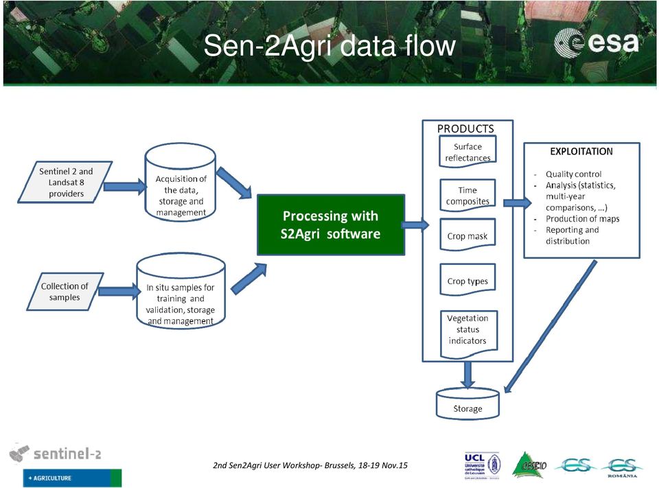
2 Sen-2Agri data flow
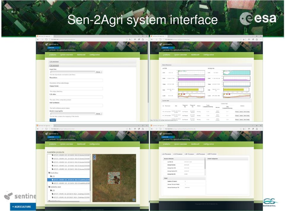
3 Sen-2Agri system interface
4 Skills requirement to run the system Different skillsare required for operating the system: Skills in computer system and networks Skills in routine processing Skills in remote sensing; Skills in field campaigns (planning, data collection, management); Skills for downstream uses of the products uses (to be tailored to user needs); Depending on the needs, skills for developing GIS tools for the analysis and exploitation of the S2Agri products; Supervision skills. These skills can be shared by different people and conversely, a single person can have different skills. Therefore, this list does not inform about the size of the team.

5 In which context do you plan to use the system: operational or scientific? Operational (Pilot) Is the Sen2Agri system matching your expectations? We have a system but if this will improve efficiency, accuracy that would be a big advantage Do you imagine to operate the system in your facility or would you prefer using only the products delivered by an external entity? We will use it as part of our existing system (in house) If you plan to operate the system, would you go for an automatic or rather a manual system operating? Probably with manual intervention.

6 What are the critical points to make this system operational according to your experience? Image management (Access, download, storage) Scale (small and large fields) climate non dependency (Drought vs excessive rain) What are the key points of attention for your institution (including the feasibility of a cloud-computing solution)? Security of results, Reliability of imagery (Landsat / Sentinel redundancy is good) Are you interested by some reprocessing capabilities? If yes, what would be the reasons for re-processing? And do you think it will be needed for all or specific products? Possibly improved algorithms, loss of archive, all products Will you expect a Sen2-Agri Graphical User Interface for products visualization? Would be nice.
 Are you interested by some reprocessing capabilities?")
7 Sudan Nora Khojali In which context do you plan to use the system: operational or scientific? First: Operationally, Next Steps Scientific Integrate tool for Agric- Surveys Is the Sen2Agri system matching your expectations? Yes! Do you imagine to operate the system in your facility or would you prefer using only the products delivered by an external entity? By our Institution facility If you plan to operate the system, would you go for an automatic or rather a manual system operating? Both of them according to our circumstance we will face

8 Sudan Nora Khojali What are the critical points to make this system operational according to your experience? - Robust Intent connection solutions = DDS -Standardization of the crops code varieties-(e.g:giews. Sudan node)-( on line helps desk) -What are the key points of attention for your institution (including the feasibility of a cloud-computing solution)? Accuracies Issues planning : Crop type map; Estimation of Agric and food production + Availability in the relevant time Are you interested by some reprocessing capabilities? If yes, what would be the reasons for re-processing? And do you think it will be needed for all or specific products? First No : latter one may be for the cloud products in the rainy season

9 Dokuchaev Soil Science Institute Igor Savin In which context do you plan to use the system: operational or scientific? Scientific and operational Is the Sen2Agri system matching your expectations? 80% Do you imagine to operate the system in your facility or would you prefer using only the products delivered by an external entity? Both If you plan to operate the system, would you go for an automatic or rather a manual system operating? Automatic

10 What are the critical points to make this system operational according to your experience? Field data availability What are the key points of attention for your institution (including the feasibility of a cloud-computing solution)? Are you interested by some reprocessing capabilities? If yes, what would be the reasons for re-processing? And do you think it will be needed for all or specific products? Yes. We are interested in open soil surface images. Will you expect a Sen2-Agri Graphical User Interface for products visualization? Yes Dokuchaev Soil Science Institute Igor Savin

11 RADI Miao Zhang In which context do you plan to use the system: operational or scientific? Local use case, more scientific than operational Is the Sen2Agri system matching your expectations? Beyond me expectation Do you imagine to operate the system in your facility or would you prefer using only the products delivered by an external entity? We can operate the system to produce products in our local case If you plan to operate the system, would you go for an automatic or rather a manual system operating? Automatic way but can be monitored, controlled

12 RADI Miao Zhang What are the critical points to make this system operational according to your experience? Continuous input What are the key points of attention for your institution (including the feasibility of a cloud-computing solution)? Reliability of the products; parallel calculation/cloud-computing Are you interested by some reprocessing capabilities? If yes, what would be the reasons for re-processing? And do you think it will be needed for all or specific products? Maybe Will you expect a Sen2-Agri Graphical User Interface for products visualization? Yes, this can leverage S2-Agri project and also improve the impact of JECAM site

13 CIRAD A. Bégué& V. Lebourgeois In which context do you plan to use the system: operational or scientific? Scientific Is the Sen2Agri system matching your expectations? Yes, but how customizable is it (use of VHSR data, radar data, thematic layers, stratification, object approach )? Do you imagine to operate the system in your facility or would you prefer using only the products delivered by an external entity? To operate it If you plan to operate the system, would you go for an automatic or rather a manual system operating? Both

14 CIRAD A. Bégué& V. Lebourgeois What are the critical points to make this system operational according to your experience? Data infrastructure (storage, backup, ) and software related issues (software installation, computing time ) What are the key points of attention for your institution (including the feasibility of a cloud-computing solution)?? Are you interested by some reprocessing capabilities? If yes, what would be the reasons for re-processing? And do you think it will be needed for all or specific products?? Will you expect a Sen2-Agri Graphical User Interface for products visualization? yes

15 Kamal LABBASSI Chouaib Doukkali University, Morocco 1-In which context do you plan to use the system: operational or scientific? Both scientific and operational (specific needs in consultation with our partners-managers). 2-Is the Sen2Agri system matching your expectations? Yes, useful for irrigation management and crop monitoring. 3-Do you imagine to operate the system in your facility or would you prefer using only the products delivered by an external entity? Operate the system in your facility/ disseminate to partners? 4-If you plan to operate the system, would you go for an automatic or rather a manual system operating? Manual at first, with a view to automatic operation in the future.

16 Kamal LABBASSI Chouaib Doukkali University, Morocco 5-What are the critical points to make this system operational according to your experience? - Format, type and origin of data (Geospatial Standards). - Interoperability with other systems. 6- What are the key points of attention for your institution (including the feasibility of a cloud-computing solution)? Development of research in the fields of geo-information and ITC. 7-Are you interested by some reprocessing capabilities? If yes, what would be the reasons for re-processing? And do you think it will be needed for all or specific products? Fusion between S1 /S2 data for enhancing and improving early-season crop classification and crop status monitoring. 8 - Will you expect a Sen2-Agri Graphical User Interface for products visualization? Yes, very practical.

17 INTA Diego de Abelleyra, Santiago Verón In which context do you plan to use the system: operational or scientific? Scientific at least in a first stage Is the Sen2Agri system matching your expectations? Yes. Provides automatizationfor RS frequent activities (e.g. cropland / crop type maps) and not so frequent (Atmospheric correction for S2, biophysical parameters estimation). Do you imagine to operate the system in your facility or would you prefer using only the products delivered by an external entity? Operate the system. Need help in distributed computing configuration with local infrastructure. Is it possible to customize the code for local situations? If you plan to operate the system, would you go for an automatic or rather a manual system operating? Automatic. We are moving towards automatization of image processing at INTA.

18 INTA Diego de Abelleyra, Santiago verón What are the critical points to make this system operational according to your experience? Time required for processing a study area, particularly for big areas (country, province level). What are the key points of attention for your institution (including the feasibility of a cloudcomputing solution)? Keep control of the processing steps. Is it possible to run remotely the system (with a particular configuration) located in a cluster? Ground truth data policy for cloud computing? Are you interested by some reprocessing capabilities? If yes, what would be the reasons for re-processing? And do you think it will be needed for all or specific products? Some times it is necessary to reprocess a product (multiple reasons). Base reflectance atmospheric correction orthorectifieddata needs to be available (not necesarilyraw data). If the system is open source, the code could be adapted for particular cases (e.g. local classification methods). Will you expect a Sen2-Agri Graphical User Interface for products visualization? Useful for non expert users. Reduced automatization?
 located in a cluster? Ground truth data policy for cloud computing? Are you interested by some reprocessing capabilities?")
19 Guido Lemoine JRC Operational use mostly, there's not too much science in NDVI in LAI (left). Complement to low resolution trends analysis to add crop specific area components to our methodology. It is still unclear whether it is a system or a toolbox. We prefer an extension of S2TBX, not a separate tool/system. In this way, there is more likelihood that it will be maintained and extended by the user community. We would run a toolbox extension as part of our internal infrastructure. Free data + open source for maximum scalability. Implementation should support both ad hoc processing (i.e. via toolbox interface) and batch processing linked with programmed downloads (e.g. OpenSearch + gpt). Proven concept for S1A.
 and batch processing linked with programmed downloads (e.")
20 Guido Lemoine - JRC Critical points for an operational system are spatial and temporal consistency of the products for arbitrary areas extending beyond single S2A coverage [but in the same agro-ecological zone]. This requires robust pre-processing (as part of S2TBX) in cloud masking, atmospheric correction and [post-classification] composition, including gap filling. Sentinel data will very likely end up in generic hosted computing infrastructures (Google Earth Engine, Amazon, etc.). Thus methods should be portable into those environments. The open source nature of the S2Agri toolbox facilitates that. We will think about re-processing after we have seen the processing outputs and understand upgrading requirements, if any. Maximum compatibility with S2TBX GUI should be aimed at.

21 FAO, Rome John Latham, Antonio Di Gregorio, Lorenzo De Simone In which context do you plan to use the system: operational or scientific? 1. Scientific to exploit system as Research User Operational synchronizing with Landsat 8 2. Operational as High level Analyst to support existing agriculture/allied departments (Operator level users) to supported all previously mentioned applications Is the Sen2Agri system matching your expectations? Yes, this will further strengthen the ongoing system development activities in FAO Do you imagine to operate the system in your facility or would you prefer using only the products delivered by an external entity? Independent operating facility at FAO, independent operational facility at FAO/ mirror site depending on plans of Google. Local, central and cloud deployment options are all feasible If you plan to operate the system, would you go for an automatic or rather a manual system operating? both for operational system for SDG targets, Agric statistics, NRM, Early Warning, DDR, Cooperative program between ESA and FAO.
22 FAO, Rome John Latham, Antonio Di Gregorio, Lorenzo De Simone What are the critical points to make this system operational according to your experience? 1. Synchronization with other critical satellites. 2. Integration with other Sentinels to overcome cloud issue 3. Proba-V sensor data integration to improvement, validation of crop calendars & monitoring of Crop phenology 4. Resource availability to operate system on local site What are the key points of attention for your institution (including the feasibility of a cloudcomputing solution)? 1. Global and regional and national agricultural and natural resource monitoring and reporting, improved capacity development at regional and national level 2. Local site based system deployment as cloud computing access is only suitable for operator level user which may be required for deployment at agriculture departments/academia only. Are you interested by some reprocessing capabilities? If yes, what would be the reasons for reprocessing? And do you think it will be needed for all or specific products? Yes, we need reprocessing capabilities (a) to improve the crop type mapping at subnational and local scale based on validation process & (b) Biophysical parameters like LAI, fapar need validation for major crop types of economic importance. Will you expect a Sen2-Agri Graphical User Interface for products visualization? Yes, GUI option will be an additional advantage for the operational use of the system.
23 SUPARCO, Pakistan Ibrar ul Hassan Akhtar & Ijaz Ahmad In which context do you plan to use the system: operational or scientific? 1. Scientific to exploit system as Research User 2. Operational as High level Analyst to support existing agriculture/allied departments (Operator level users) for food security and agriculture statistics. Is the Sen2Agri system matching your expectations? Yes, this will further strengthen the ongoing system development activities in SUPARCO Do you imagine to operate the system in your facility or would you prefer using only the products delivered by an external entity? Independent operating facility at SUPARCO, Islamabad office If you plan to operate the system, would you go for an automatic or rather a manual system operating? Automatic system will be preferred to ensure implementation of Sen2-Agri System as an operational system for crops monitoring, rapid crops damage assessments due to floods & Droughts and ensure food security in Pakistan.
24 SUPARCO, Pakistan Ibrar ul Hassan Akhtar & Ijaz Ahmad What are the critical points to make this system operational according to your experience? 1. Integration with microwave Sentinel1 satellite data to overcome the cloud issues in Monsoon. 2. Proba-V sensor data integration to establish the local crop calendars & Crop phenology for efficient/effective data acquisition plans. 3. Resource availability to operate system on local site What are the key points of attention for your institution (including the feasibility of a cloudcomputing solution)? 1. Local site based system deployment as cloud computing access is only suitable for operator level user which may be required for deployment at agriculture departments/academia only. 2. Capacity building for the customization of the system Are you interested by some reprocessing capabilities? If yes, what would be the reasons for reprocessing? And do you think it will be needed for all or specific products? Yes, we need reprocessing capabilities (a) to improve the crop type mapping at subnational and local scale based on validation process & (b) Biophysical parameters like LAI, fapar need validation for major crop types of economic importance. Will you expect a Sen2-Agri Graphical User Interface for products visualization? Yes, GUI option will be an additional advantage for the operational use of the system.
25 USDA/ARS Andrew French In which context do you plan to use the system: operational or scientific? Scientific research and demonstration Is the Sen2Agri system matching your expectations? No experience yet. Do you imagine to operate the system in your facility or would you prefer using only the products delivered by an external entity? Yes, self-sufficiency desirable. If you plan to operate the system, would you go for an automatic or rather a manual system operating? Automated system preferred.
26 ICRISAT P.C.S. Traore In which context do you plan to use the system: operational or scientific? Both: discovery level for advisory services in Koutiala district, and operational support for governmental agricultural statistics (national scale) Is the Sen2Agri system matching your expectations? Partially crop-dependent LAI response, crop type determination based on previous year s data would be welcome; possible tradeoffs between bandwidth and field data collection Do you imagine to operate the system in your facility or would you prefer using only the products delivered by an external entity? Both in situ and cloud based depends on how well the national team will be able to control bandwidth usage on site If you plan to operate the system, would you go for an automatic or rather a manual system operating? Both automatic for statistics department, with manual option in collaboration with research institutions
27 ICRISAT P.C.S. Traore What are the critical points to make this system operational according to your experience? Adequate level of proximal backstopping in use of the system What are the key points of attention for your institution (including the feasibility of a cloud-computing solution)? Building trust regarding ownership of cloud-based data Are you interested by some reprocessing capabilities? If yes, what would be the reasons for re-processing? And do you think it will be needed for all or specific products? Yes crop-specific LAI and phenology metrics Will you expect a Sen2-Agri Graphical User Interface for products visualization? yes
28 Manobi Madieye In which context do you plan to use the system: operational or scientific? As we partner with scientific faculties, our experimentation would be an action-research. But we plan to put an emphasis on operational test of the system since our aim is to transform all this data into usable products for crop management. Is the Sen2Agri system matching your expectations? Not tested yet Do you imagine to operate the system in your facility or would you prefer using only the products delivered by an external entity? In our own facility; Manobi already develops mobile applications and server incorporating remote sensing data. So we already have the structure and know-how to operate this system. If you plan to operate the system, would you go for an automatic or rather a manual system operating? Automated system preferred. Solutions we already developed provide automated gateway between server collecting RS data and software processing that data and transforming it into intermediate data. Similar functioning would be used within this project, where an automated use with predefined expected contents would be the way to go.
29 Manobi Madieye What are the critical points to make this system operational according to your experience? Test during the demonstration phase the possibility to use this data for concrete purposes such as index insurance, agronomic advice etc. Are you interested by some reprocessing capabilities? If yes, what would be the reasons for re-processing? And do you think it will be needed for all or specific products? Depending on the use of the data reprocessing might be needed to adjust the outputs to the objectives. Will you expect a Sen2-Agri Graphical User Interface for products visualization? Yes
30 World Food Program Rogerio Bonifacio In which context do you plan to use the system: operational or scientific? Operational humanitarian applications. Some focused applied research may be undertaken Is the Sen2Agri system matching your expectations? Yes (but new to this type of data) Do you imagine to operate the system in your facility or would you prefer using only the products delivered by an external entity? TBD. External products in early stages, but strong interest in HQ-level in situ operations. WFP Regional Bureaus (if using) limited to delivered products If you plan to operate the system, would you go for an automatic or rather a manual system operating? Initially automatic, but likely to experiment manual system operation at some stage
31 World Food Program Rogerio Bonifacio What are the critical points to make this system operational according to your experience? Field data acquisition poses problems due to i) mandate, ii) major interest lies in areas of restricted access or government capacity What are the key points of attention for your institution (including the feasibility of a cloud-computing solution)? Distributed geographical scope of WFP ROIs. Cloud relevant for non-hq Are you interested by some reprocessing capabilities? If yes, what would be the reasons for re-processing? And do you think it will be needed for all or specific products? For historical data? Not an immediate priority, but could prove relevant. 3 to 6 month lookbacks are operationally very important Will you expect a Sen2-Agri Graphical User Interface for products visualization? If it offers features that cannot be found in available software
IMAGINES_VALIDATIONSITESNETWORK ISSUE 1.00. EC Proposal Reference N FP7-311766. Name of lead partner for this deliverable: EOLAB
 Date Issued: 26.03.2014 Issue: I1.00 IMPLEMENTING MULTI-SCALE AGRICULTURAL INDICATORS EXPLOITING SENTINELS RECOMMENDATIONS FOR SETTING-UP A NETWORK OF SITES FOR THE VALIDATION OF COPERNICUS GLOBAL LAND
Copernicus Space Component Data Access Architecture. Meeting with Austria 27 May 2014, Vienna
 Copernicus Space Component Data Access Architecture Meeting with Austria 27, Vienna Copernicus Data Policy Users shall have free, full and open access to Copernicus dedicated Sentinel data and Copernicus
JECAM Site Ukraine. 21 23 July 2014. Team Leader: Kussul Nataliia. JECAM/GEOGLAM Science Meeting Ottawa, Canada
 Site Ukraine /GEOGLAM Science, Canada 21 23 July Team Leader: Kussul Nataliia Members: Shelestov Andrii, Skakun Sergii Site Description Kyiv oblast (SRI, area 28,000 km 2 ) & intensive observation sub-site
An Esri White Paper June 2011 ArcGIS for INSPIRE
 An Esri White Paper June 2011 ArcGIS for INSPIRE Esri, 380 New York St., Redlands, CA 92373-8100 USA TEL 909-793-2853 FAX 909-793-5953 E-MAIL info@esri.com WEB esri.com Copyright 2011 Esri All rights reserved.
gebruiken voor aardse toepassingen
 26/03/2014 Satellietgegevens gebruiken voor aardse toepassingen Dirk Van Speybroeck dirk.vanspeybroeck@vito.be VITO, VIsion on TechnOlogy» een op Europees vlak toonaangevend, onafhankelijk onderzoeks-
Copernicus Space Component ESA Data Access Overview J. Martin (ESA), R. Knowelden (Airbus D&S)
, R. Knowelden (Airbus D&S)") Copernicus Space Component ESA Data Access Overview J. Martin (ESA), R. Knowelden (Airbus D&S) Introduction and Context Operational Scenarios Translation into interfaces Translation into services Current
Copernicus Space Component ESA Data Access Overview J. Martin (ESA), R. Knowelden (Airbus D&S) Introduction and Context Operational Scenarios Translation into interfaces Translation into services Current
Digital Remote Sensing Data Processing Digital Remote Sensing Data Processing and Analysis: An Introduction and Analysis: An Introduction
 Digital Remote Sensing Data Processing Digital Remote Sensing Data Processing and Analysis: An Introduction and Analysis: An Introduction Content Remote sensing data Spatial, spectral, radiometric and
Forestry Thematic Exploitation Platform Earth Observation Open Science 2.0
 Forestry Thematic Exploitation Platform Earth Observation Open Science 2.0 Tuomas Häme VTT Technical Research of Finland Ltd and the Forestry TEP Team Objective One-stop shop for forestry remote sensing
GIS Initiative: Developing an atmospheric data model for GIS. Olga Wilhelmi (ESIG), Jennifer Boehnert (RAP/ESIG) and Terri Betancourt (RAP)
, Jennifer Boehnert (RAP/ESIG) and Terri Betancourt (RAP)") GIS Initiative: Developing an atmospheric data model for GIS Olga Wilhelmi (ESIG), Jennifer Boehnert (RAP/ESIG) and Terri Betancourt (RAP) Unidata seminar August 30, 2004 Presentation Outline Overview
GIS Initiative: Developing an atmospheric data model for GIS Olga Wilhelmi (ESIG), Jennifer Boehnert (RAP/ESIG) and Terri Betancourt (RAP) Unidata seminar August 30, 2004 Presentation Outline Overview
Global environmental information Examples of EIS Data sets and applications
 METIER Graduate Training Course n 2 Montpellier - february 2007 Information Management in Environmental Sciences Global environmental information Examples of EIS Data sets and applications Global datasets
Geospatial intelligence and data fusion techniques for sustainable development problems
 Geospatial intelligence and data fusion techniques for sustainable development problems Nataliia Kussul 1,2, Andrii Shelestov 1,2,4, Ruslan Basarab 1,4, Sergii Skakun 1, Olga Kussul 2 and Mykola Lavreniuk
Linking Sensor Web Enablement and Web Processing Technology for Health-Environment Studies
 Linking Sensor Web Enablement and Web Processing Technology for Health-Environment Studies Simon Jirka 1, Stefan Wiemann 2, Johannes Brauner 2, and Eike Hinderk Jürrens 1 1 52 North Initiative for Geospatial
Welcome to NASA Applied Remote Sensing Training (ARSET) Webinar Series
 Webinar Series") Welcome to NASA Applied Remote Sensing Training (ARSET) Webinar Series Introduction to Remote Sensing Data for Water Resources Management Course Dates: October 17, 24, 31 November 7, 14 Time: 8-9 a.m.
Welcome to NASA Applied Remote Sensing Training (ARSET) Webinar Series Introduction to Remote Sensing Data for Water Resources Management Course Dates: October 17, 24, 31 November 7, 14 Time: 8-9 a.m.
The Challenges of Geospatial Analytics in the Era of Big Data
 The Challenges of Geospatial Analytics in the Era of Big Data Dr Noordin Ahmad National Space Agency of Malaysia (ANGKASA) CITA 2015: 4-5 August 2015 Kuching, Sarawak Big datais an all-encompassing term
The USGS Landsat Big Data Challenge
 The USGS Landsat Big Data Challenge Brian Sauer Engineering and Development USGS EROS bsauer@usgs.gov U.S. Department of the Interior U.S. Geological Survey USGS EROS and Landsat 2 Data Utility and Exploitation
Task AR-09-01a Progress and Contributions
 Doug Nebert, POC U.S. Geological Survey ddnebert@usgs.gov March 2010 Task AR-09-01a Progress and Contributions Background and scope for AR-09-01a This Task defines the minimum, common technical capabilities
Review for Introduction to Remote Sensing: Science Concepts and Technology
 Review for Introduction to Remote Sensing: Science Concepts and Technology Ann Johnson Associate Director ann@baremt.com Funded by National Science Foundation Advanced Technological Education program [DUE
Automatic land-cover map production of agricultural areas using supervised classification of SPOT4(Take5) and Landsat-8 image time series.
 and Landsat-8 image time series.") Automatic land-cover map production of agricultural areas using supervised classification of SPOT4(Take5) and Landsat-8 image time series. Jordi Inglada 2014/11/18 SPOT4/Take5 User Workshop 2014/11/18
Automatic land-cover map production of agricultural areas using supervised classification of SPOT4(Take5) and Landsat-8 image time series. Jordi Inglada 2014/11/18 SPOT4/Take5 User Workshop 2014/11/18
CROSS PLATFORM AUTOMATIC FILE REPLICATION AND SERVER TO SERVER FILE SYNCHRONIZATION
 1 E N D U R A D A T A EDpCloud: A File Synchronization, Data Replication and Wide Area Data Distribution Solution CROSS PLATFORM AUTOMATIC FILE REPLICATION AND SERVER TO SERVER FILE SYNCHRONIZATION 2 Resilient
SPOT4 (Take 5) first validation and application results
 first validation and application results") SPOT4 (Take 5) first validation and application results O.Hagolle CESBIO/CNES, M.Huc CESBIO/CNRS, M.Kadiri CESBIO/THEIA ; J.Inglada CESBIO/CNES, C. Marais-Sicre CESBIO/CNRS, J.Osman CESBIO/CNES (PhD),
SPOT4 (Take 5) first validation and application results O.Hagolle CESBIO/CNES, M.Huc CESBIO/CNRS, M.Kadiri CESBIO/THEIA ; J.Inglada CESBIO/CNES, C. Marais-Sicre CESBIO/CNRS, J.Osman CESBIO/CNES (PhD),
BLACKBRIDGE SATELLITE IMAGERY THROUGH CLOUD COMPUTING
 BLACKBRIDGE SATELLITE IMAGERY THROUGH CLOUD COMPUTING Jason Setzer Cloud Product Manager Slide 1 THE RAPID EYE CONSTELLATION 5 Identical Satellites in same obit Up to 5 million km² collected daily 1 billion
The Agroclimate Impact Reporter
 The Agroclimate Impact Reporter Allan Howard, P. Cherneski, T. Hadwen, S. Sutherland and D. Chobanyk Natrional Agroclimate Information Service, Science & Technology Branch Agriculture and Agri Food Canada
SatelliteRemoteSensing for Precision Agriculture
 SatelliteRemoteSensing for Precision Agriculture Managing Director WasatSp. z o.o. Copernicus the road to economic development Warsaw, 26-27 February 2015 Activitiesof WasatSp. z o.o. The company provides
Big Data in the context of Preservation and Value Adding
 Big Data in the context of Preservation and Value Adding R. Leone, R. Cosac, I. Maggio, D. Iozzino ESRIN 06/11/2013 ESA UNCLASSIFIED Big Data Background ESA/ESRIN organized a 'Big Data from Space' event
Sentinels Operations Konzept und Prinzipien des Datenzugangs - Copernicus Space Component Data Access Overview
 Sentinels Operations Konzept und Prinzipien des Datenzugangs - Copernicus Space Component Data Overview B. Hoersch Ground Segment and Mission Operations Department, Earth Observation Programmes Directorate,
GIS BASED LAND INFORMATION SYSTEM FOR MANDAL SOUM, SELENGE AIMAG OF MONGOLIA
 GIS BASED LAND INFORMATION SYSTEM FOR MANDAL SOUM, SELENGE AIMAG OF MONGOLIA B. Tuul GTZ, Land Management and Fiscal Cadastre project, Government building 12, ALAGCaC, Ulaanbaatar, Mongolia tuul1119@yahoo.com,
Operational Space- Based Crop Mapping Protocols at AAFC A. Davidson, H. McNairn and T. Fisette.
 Operational Space- Based Crop Mapping Protocols at AAFC A. Davidson, H. McNairn and T. Fisette. Science & Technology Branch. Agriculture and Agri-Food Canada. 1. Introduction Space-Based Crop Mapping at
Emergency Management Service. early warning FLOOD AND FIRE ALERTS. Space
 Emergency Management Service early warning FLOOD AND FIRE ALERTS Space 1 Copernicus at a Glance Copernicus is the European Union s Earth Observation programme: a user-driven space programme under civil
Managing Large Imagery Databases via the Web
 'Photogrammetric Week 01' D. Fritsch & R. Spiller, Eds. Wichmann Verlag, Heidelberg 2001. Meyer 309 Managing Large Imagery Databases via the Web UWE MEYER, Dortmund ABSTRACT The terramapserver system is
Big Data and Official Statistics The UN Global Working Group
 Big Data and Official Statistics The UN Global Working Group Dr. Ronald Jansen Chief, International Trade Statistics United Nations Statistics Division jansen1@un.org Overview What is Big Data? What is
Remote sensing information cloud service: research and practice
 Remote sensing information cloud service: research and practice Yang Banghui Dr., Ren Fuhu Prof. and Wang jinnian Prof. yangbh@radi.ac.cn +8613810963452 Content 1 Background 2 Studying and Designing 3
Monitoring Overview with a Focus on Land Use Sustainability Metrics
 Monitoring Overview with a Focus on Land Use Sustainability Metrics Canadian Roundtable for Sustainable Crops. Nov 26, 2014 Agriclimate, Geomatics, and Earth Observation Division (ACGEO). Presentation
GLOBAL MONITORING FOR FOOD SECURITY IM SUDAN
 GLOBAL MONITORING FOR FOOD SECURITY IM SUDAN GMFS 3 Carsten Haub & Klaus-Ulrich Komp 18.11.2010 www.eftas.com 1 World hunger World Summit on Food Security FAO, Rome 11.2009 Mehr als 1 Milliarde Mensche
EO data hosting and processing core capabilities and emerging solutions
 EO data hosting and processing core capabilities and emerging solutions Andrew Groom 4 th March 2015 Contents An introduction to Airbus Defence and Space, Geo-Intelligence Elements of the C3S vision EO
Big Data and Cloud Computing for GHRSST
 Big Data and Cloud Computing for GHRSST Jean-Francois Piollé (jfpiolle@ifremer.fr) Frédéric Paul, Olivier Archer CERSAT / Institut Français de Recherche pour l Exploitation de la Mer Facing data deluge
SNOWTOOLS RESEARCH AND DEVELOPMENT OF REMOTE SENSING METHODS FOR SNOW HYDROLOGY
 SNOWTOOLS RESEARCH AND DEVELOPMENT OF REMOTE SENSING METHODS FOR SNOW HYDROLOGY Tore Guneriussen 1, Rune Solberg 2, Sjur Kolberg 3, Martti Hallikainen 4, Jarkko Koskinen 4, Daniel Hiltbrunner 5, Christian
Monitoring Global Crop Condition Indicators Using a Web-Based Visualization Tool
 Monitoring Global Crop Condition Indicators Using a Web-Based Visualization Tool Bob Tetrault, Regional Commodity Analyst, and Bob Baldwin, GIS Specialist, USDA, Foreign Agricultural Service, Washington,
Digital image processing
 746A27 Remote Sensing and GIS Lecture 4 Digital image processing Chandan Roy Guest Lecturer Department of Computer and Information Science Linköping University Digital Image Processing Most of the common
A Future Scenario of interconnected EO Platforms How will EO data be used in 2025?
 A Future Scenario of interconnected EO Platforms How will EO data be used in 2025? ESA UNCLASSIFIED For Official Use European EO data asset Heritage missions Heritage Core GS (data preservation, curation
SCIENCE DATA ANALYSIS ON THE CLOUD
 SCIENCE DATA ANALYSIS ON THE CLOUD ESIP Cloud Computing Cluster Thomas Huang and Phil Yang Agenda Invited speakers Petr Votava, NASA Earth Exchange (NEX): Early Observations on Community Engagement in
The needs on big data management for Operational Geo-Info Services: Emergency Response, Maritime surveillance, Agriculture Management
 Copernicus Big-Data Workshop 2014, 13/14 March The needs on big data management for Operational Geo-Info Services: Emergency Response, Maritime surveillance, Agriculture Management Marco Corsi e-geos 1
JRC and GMES GIO-EMS
 Joint Research Centre JRC and GMES GIO-EMS Guido Lemoine, Jan Kucera, Marco Broglia JRC, Ispra 1st GMES NATIONAL USER FORUM DAY Prague, 29-30 May 2012 Serving society Stimulating innovation Supporting
Implementation of information system to respond to a nuclear emergency affecting agriculture and food products - Case of Morocco
 Centre National de l énergie des sciences et techniques nucléaires (CNESTEN-Morocco) Implementation of information system to respond to a nuclear emergency affecting agriculture and food products - Case
Big Data Infrastructures for Processing Sentinel Data
 Big Data Infrastructures for Processing Sentinel Data Wolfgang Wagner Department for Geodesy and Geoinformation Technische Universität Wien Earth Observation Data Centre for Water Resources Monitoring
Moderate- and high-resolution Earth Observation data based forest and agriculture monitoring in Russia using VEGA Web-Service
 Moderate- and high-resolution Earth Observation data based forest and agriculture monitoring in Russia using VEGA Web-Service Sergey BARTALEV and Evgeny LOUPIAN Space Research Institute, Russian Academy
Improving global data on forest area & change Global Forest Remote Sensing Survey
 Improving global data on forest area & change Global Forest Remote Sensing Survey work by FAO and partners - Adam Gerrand, E. Lindquist, R. D Annunzio, M. Wilkie, FAO, - F. Achard et al. TREES team at
Big data and Earth observation New challenges in remote sensing images interpretation
 Big data and Earth observation New challenges in remote sensing images interpretation Pierre Gançarski ICube CNRS - Université de Strasbourg 2014 Pierre Gançarski Big data and Earth observation 1/58 1
I.Jonckheere, E. Lindquist & A. Pekkarinen FAO Forestry Department
 Space Data Management System (SDMS) Acquire, Query, Process and Deliver Earth Observation Data and Forest Information Products to Developing Countries Pilot & Project I.Jonckheere, E. Lindquist & A. Pekkarinen
APPLICATION OF GOOGLE EARTH FOR THE DEVELOPMENT OF BASE MAP IN THE CASE OF GISH ABBAY SEKELA, AMHARA STATE, ETHIOPIA
 APPLICATION OF GOOGLE EARTH FOR THE DEVELOPMENT OF BASE MAP IN THE CASE OF GISH ABBAY SEKELA, AMHARA STATE, ETHIOPIA Abineh Tilahun Department of Geography and environmental studies, Adigrat University,
On Demand Satellite Image Processing
 On Demand Satellite Image Processing Next generation technology for processing Terabytes of imagery on the Cloud WHITEPAPER MARCH 2015 Introduction Profound changes are happening with computing hardware
13 th EC GI & GIS Workshop WIN: A new OGC compliant SOA. for risk management. GMV, 2007 Property of GMV All rights reserved
 13 th EC GI & GIS Workshop WIN: A new OGC compliant SOA for risk management GMV, 2007 Property of GMV All rights reserved Content 1. Introduction 2. Objectives 3. Architecture and Model 4. Technical aspects
GEOSPATIAL DIGITAL ASSET MANAGEMENT A SOLUTION INTEGRATING IMAGERY AND GIS WHERE WILL ALL THE PIXELS GO?(AND HOW WILL WE EVER FIND THEM?
 GEOSPATIAL DIGITAL ASSET MANAGEMENT A SOLUTION INTEGRATING IMAGERY AND GIS WHERE WILL ALL THE PIXELS GO?(AND HOW WILL WE EVER FIND THEM?) Dr. Joan Lurie, GCC, Inc. 30 West 61 st Street, Apt 9A New York,
The Use of Geographic Information Systems in Risk Assessment
 The Use of Geographic Information Systems in Risk Assessment With Specific Focus on the RiVAMP Methodology Presented by Nadine Brown August 27, 2012 Climate Studies Group Mona Climate Change Workshop Presentation
Accuracy Assessment of Land Use Land Cover Classification using Google Earth
 American Journal of Environmental Protection 25; 4(4): 9-98 Published online July 2, 25 (http://www.sciencepublishinggroup.com/j/ajep) doi:.648/j.ajep.2544.4 ISSN: 228-568 (Print); ISSN: 228-5699 (Online)
AAFC Medium-Resolution EO Data Activities for Agricultural Risk Assessment
 AAFC Medium-Resolution EO Data Activities for Agricultural Risk Assessment North American Drought Monitor (NADM) Ottawa, Ontario, Canada. October 15-17 2008. A. Davidson 1, A. Howard 1,2, K. Sun 1, M.
ENVI THE PREMIER SOFTWARE FOR EXTRACTING INFORMATION FROM GEOSPATIAL IMAGERY.
 ENVI THE PREMIER SOFTWARE FOR EXTRACTING INFORMATION FROM GEOSPATIAL IMAGERY. ENVI Imagery Becomes Knowledge ENVI software uses proven scientific methods and automated processes to help you turn geospatial
Strategic Plan FY 2014-2016
 Strategic Plan FY 2014-2016 CONTENTS SUMMARY 3 ACADEMIC SERVICES 4 DATA MANAGEMENT & REPORTING 6 COMMUNICATIONS & COLLABORATION 7 IT SERVICES 8 INFRASTRUCTURE 9 SECURITY 10 BRAND BUILDING 11 INITIATION
Cloud Computing for SCADA
 Cloud Computing for SCADA Moving all or part of SCADA applications to the cloud can cut costs significantly while dramatically increasing reliability and scalability. A White Paper from InduSoft Larry
Virtual constellations, time series, and cloud screening opportunities for Sentinel 2 and Landsat
 Virtual constellations, time series, and cloud screening opportunities for Sentinel 2 and Landsat Sentinel 2 for Science Workshop 20 22 May 2014 ESA ESRIN, Frascati (Rome), Italy 1 Part 1: Title: Towards
VCS REDD Methodology Module. Methods for monitoring forest cover changes in REDD project activities
 1 VCS REDD Methodology Module Methods for monitoring forest cover changes in REDD project activities Version 1.0 May 2009 I. SCOPE, APPLICABILITY, DATA REQUIREMENT AND OUTPUT PARAMETERS Scope This module
A Web Service based U.S. Cropland Visualization, Dissemination and Querying System
 A Web Service based U.S. Cropland Visualization, Dissemination and Querying System Rick Mueller, Zhengwei Yang, and Dave Johnson USDA/National Agricultural Statistics Service Weiguo Han and Liping Di GMU/Center
Data access and management
 B Data access and management CONTENTS B.1 Introduction... B-1 B.2 Data requirements and availability... B-1 B.3 Data access... B-2 B.4 Overall procedures... B-2 B.5 Data tools and management... B-4 Appendix
Breeze Development. Wind Resource Assessment System. Modern software for wind energy site evaluation and management.
 Breeze Development Wind Resource Assessment System Modern software for wind energy site evaluation and management. PRODUCT OVERVIEW Contents Contents 2 Company Overview 4 Increase Data Availability 5 Value
A New Cloud-based Deployment of Image Analysis Functionality
 243 A New Cloud-based Deployment of Image Analysis Functionality Thomas BAHR 1 and Bill OKUBO 2 1 Exelis Visual Information Solutions GmbH, Gilching/Germany thomas.bahr@exelisvis.com 2 Exelis Visual Information
Land Use/ Land Cover Mapping Initiative for Kansas and the Kansas River Watershed
 Land Use/ Land Cover Mapping Initiative for Kansas and the Kansas River Watershed Kansas Biological Survey Kansas Applied Remote Sensing Program April 2008 Previous Kansas LULC Projects Kansas LULC Map
Using D2K Data Mining Platform for Understanding the Dynamic Evolution of Land-Surface Variables
 Using D2K Data Mining Platform for Understanding the Dynamic Evolution of Land-Surface Variables Praveen Kumar 1, Peter Bajcsy 2, David Tcheng 2, David Clutter 2, Vikas Mehra 1, Wei-Wen Feng 2, Pratyush
LEOworks - a freeware to teach Remote Sensing in Schools
 LEOworks - a freeware to teach Remote Sensing in Schools Wolfgang Sulzer Institute for Geography and Regional Science University of Graz Heinrichstrasse 36, A-8010 Graz/Austria wolfgang.sulzer@uni-graz.at
Enterprise GIS Solutions to GIS Data Dissemination
 Enterprise GIS Solutions to GIS Data Dissemination ESRI International User Conference July 13 17, 2009 Wendy M. Turner Senior GIS Engineer & Program Manager Freedom Consulting Group, LLC Building the Enterprise
Advanced Metering Information Systems
 e Executive Brief: Advanced ing Information s Introduction e s mission is to help utilities maximize the value of their advanced metering infrastructure ( AMI ) and fixed network 1 investments. Most utilities
The premier software for extracting information from geospatial imagery.
 Imagery Becomes Knowledge ENVI The premier software for extracting information from geospatial imagery. ENVI Imagery Becomes Knowledge Geospatial imagery is used more and more across industries because
Cost effective methods of test environment management. Prabhu Meruga Director - Solution Engineering 16 th July SCQAA Irvine, CA
 Cost effective methods of test environment management Prabhu Meruga Director - Solution Engineering 16 th July SCQAA Irvine, CA 2013 Agenda Basic complexity Dynamic needs for test environments Traditional
Database-driven web mapping using jquery, PHP, PostgreSQL & SDE
 Database-driven web mapping using jquery, PHP, PostgreSQL & SDE By, Jon Nordling, Michael Humber Inbal Becker-Reshef, Brian Barker, Katie McGaughey, Chris Justice University of Maryland College Park http://geoglam-crop-monitor.org/
GEO Joint Experiment for Crop Assessment and Monitoring (JECAM): Template for Research Progress Report
: Template for Research Progress Report") GEO Joint Experiment for Crop Assessment and Monitoring (JECAM): Template for Research Progress Report Date: 17 th February 2015 JECAM Test Site Name: Bambey, Sénégal Team Leader and Members: Cirad Valérie
GEO Joint Experiment for Crop Assessment and Monitoring (JECAM): Template for Research Progress Report Date: 17 th February 2015 JECAM Test Site Name: Bambey, Sénégal Team Leader and Members: Cirad Valérie
ENVI Services Engine: Scientific Data Analysis and Image Processing for the Cloud
 ENVI Services Engine: Scientific Data Analysis and Image Processing for the Cloud Bill Okubo, Greg Terrie, Amanda O Connor, Patrick Collins, Kevin Lausten The information contained in this document pertains
Schneider Electric North America. Boston, Massachusetts
 Schneider Electric North America Boston, Massachusetts Testimony of Ron Sznaider, Senior Vice President, Weather Division, Schneider Electric IN SUPPORT OF How Can We Better Communicate Weather to Enhance
The Role of GARNET-E in supporting Disaster Management and Emergency Response for Africa
 The Role of GARNET-E in supporting Disaster Management and Emergency Response for Africa Presented by Prof. Isi Ikhuoria Regional Centre for Training in Aerial Surveys (RECTAS), Nigeria at The 9 th EUMETSAT
Providing On-Demand Situational Awareness
 ITT Exelis Geospatial Intelligence Solutions Providing On-Demand Situational Awareness Use of U.S. Department of Defense (DoD) and U.S. Army imagery in this brochure does not constitute or imply DoD or
Can Cloud Technology Help You to Improve Performance, Scalability, and Cost of Geo- Spatial Applications When Your Budget is shrinking?
 Creating Value Can Cloud Technology Help You to Improve Performance, Scalability, and Cost of Geo- Spatial Applications When Your Budget is shrinking? Delivering Solutions Overview of the Presentation
Long Term Preservation of Earth Observation Space Data. Preservation Workflow
 Long Term Preservation of Earth Observation Space Data Preservation Workflow CEOS-WGISS Doc. Ref.: CEOS/WGISS/DSIG/PW Data Stewardship Interest Group Date: March 2015 Issue: Version 1.0 Preservation Workflow
Application of Space Technology for Disaster monitoring and assessment current state in Vietnam
 Application of Space Technology for Disaster monitoring and assessment current state in Vietnam Lai Anh Khoi SPACE TECHNOLOGY INSTITUTE 8th GEOSS Asian Pacific Symposium Beijing, Sep. 09-11, 2015 Types
Developing Fleet and Asset Tracking Solutions with Web Maps
 Developing Fleet and Asset Tracking Solutions with Web Maps Introduction Many organizations have mobile field staff that perform business processes away from the office which include sales, service, maintenance,
VMware Business Continuity and Disaster Recovery Technology Consulting Services
 VMware Business Continuity and Disaster Recovery Technology Consulting Services VMware Technology Consulting Services for Business Continuity and Disaster Recovery CIOs need people both internal staff
Asia and Pacific Commission on Agricultural Statistics
 October 2012 APCAS/12/22 Asia and Pacific Commission on Agricultural Statistics Twenty-fourth Session Da Lat, Viet Nam, 8-12 October 2012 Agenda Item 9 Use of Smart-phones for food and agricultural price
INVESTIGA I+D+i 2013/2014
 INVESTIGA I+D+i 2013/2014 SPECIFIC GUIDELINES ON AEROSPACE OBSERVATION OF EARTH Text by D. Eduardo de Miguel October, 2013 Introducction Earth observation is the use of remote sensing techniques to better
November 3-4, 2015. The BioMA platform and applications. European Project n 613817 Workshop November 3 rd 2015. Marcello Donatelli (CREA)
") European Project n 613817 Workshop November 3 rd 2015 The BioMA platform and applications Marcello Donatelli (CREA) November 3-4, 2015 Outline Do we need a modelling framework? What is BioMA? BioMA applications
European Project n 613817 Workshop November 3 rd 2015 The BioMA platform and applications Marcello Donatelli (CREA) November 3-4, 2015 Outline Do we need a modelling framework? What is BioMA? BioMA applications
VITO Centre of Image Processing
 07/11/2013 VITO Centre of Image Processing Towards an Improved Scientific Exploitation of EO Data Sources in Support of Vegetation Monitoring Erwin Goor, VITO nv Outline» Introduction» The role & and objectives
Geospatial Software Solutions for the Environment and Natural Resources
 Geospatial Software Solutions for the Environment and Natural Resources Manage and Preserve the Environment and its Natural Resources Our environment and the natural resources it provides play a growing
ArcGIS. Server. A Complete and Integrated Server GIS
 ArcGIS Server A Complete and Integrated Server GIS ArcGIS Server A Complete and Integrated Server GIS ArcGIS Server enables you to distribute maps, models, and tools to others within your organization
LEVERAGE VBLOCK SYSTEMS FOR Esri s ArcGIS SYSTEM
 Leverage Vblock Systems for Esri's ArcGIS System Table of Contents www.vce.com LEVERAGE VBLOCK SYSTEMS FOR Esri s ArcGIS SYSTEM August 2012 1 Contents Executive summary...3 The challenge...3 The solution...3
Chapter Contents Page No
 Chapter Contents Page No Preface Acknowledgement 1 Basics of Remote Sensing 1 1.1. Introduction 1 1.2. Definition of Remote Sensing 1 1.3. Principles of Remote Sensing 1 1.4. Various Stages in Remote Sensing
ESA Earth Observation Big Data R&D Past, Present, & Future Activities
 ESA Earth Observation Big Data R&D Past, Present, & Future Activities [Sveinung.Loekken, Jordi.Farres]@esa.int Ground Segment and Mission Operations Department, Earth Observation Programmes Directorate,
Remote Sensing in Natural Resources Mapping
 Remote Sensing in Natural Resources Mapping NRS 516, Spring 2016 Overview of Remote Sensing in Natural Resources Mapping What is remote sensing? Why remote sensing? Examples of remote sensing in natural
THE STRATEGIC PLAN OF THE HYDROMETEOROLOGICAL PREDICTION CENTER
 THE STRATEGIC PLAN OF THE HYDROMETEOROLOGICAL PREDICTION CENTER FISCAL YEARS 2012 2016 INTRODUCTION Over the next ten years, the National Weather Service (NWS) of the National Oceanic and Atmospheric Administration
GXP WebView GEOSPATIAL EXPLOITATION PRODUCTS (GXP )
") GEOSPATIAL EXPLOITATION PRODUCTS (GXP ) GXP WebView A Web-based, full-resolution image viewing tool for visualization, annotation, measurement, and publishing providing access to remote data from any location.
GEOSPATIAL EXPLOITATION PRODUCTS (GXP ) GXP WebView A Web-based, full-resolution image viewing tool for visualization, annotation, measurement, and publishing providing access to remote data from any location.
ForeCAST : Use of VHR satellite data for forest cartography
 ForeCAST : Use of VHR satellite data for forest cartography I-MAGE CONSULT UCL- Dpt Sciences du Milieu et de l Aménagement du Territoire Description of the partnership I-MAGE Consult Private partner Team
Cloud Computing for Architects
 Cloud Computing for Architects This four day, hands-on boot camp begins with an examination of the Cloud Computing concept, the structure and key characteristics of Clouds, and takes a look under the hood
Food security services - GMFS GMES services element. Using ENVISAT MERIS and ASAR for monitoring Agriculture in Africa. http://www.gmfs.
 Food security services - GMFS GMES services element Using ENVISAT MERIS and ASAR for monitoring Agriculture in Africa This presentation - Food (in)security? - Policies, global and european actions - Information
Norwegian Satellite Earth Observation Database for Marine and Polar Research http://normap.nersc.no USE CASES
 Norwegian Satellite Earth Observation Database for Marine and Polar Research http://normap.nersc.no USE CASES The NORMAP Project team has prepared this document to present functionality of the NORMAP portal.
Deploying a Geospatial Cloud
 Deploying a Geospatial Cloud Traditional Public Sector Computing Environment Traditional Computing Infrastructure Silos of dedicated hardware and software Single application per silo Expensive to size
A case study in cloud computing
 A case study in cloud computing Greg Levow President & Chief Operating Officer Agronomic Technology Corp greg@agronomic.com November 3, 2014 Topics: What is the cloud? What it means for companies and users