Database-driven web mapping using jquery, PHP, PostgreSQL & SDE
|
|
|
- Antony Baldwin
- 10 years ago
- Views:
Transcription
1 Database-driven web mapping using jquery, PHP, PostgreSQL & SDE By, Jon Nordling, Michael Humber Inbal Becker-Reshef, Brian Barker, Katie McGaughey, Chris Justice University of Maryland College Park

2 Overview About the GEOGLAM Crop Monitor Look at different phases of development as the application advanced Understanding the roles of the different technologies used jquery, PHP, PostgreSQL & SDE, etc. Developing ArcGIS Mapping application with total customization flexibility

3 About GEOGLAM Group on Earth Observations (GEO) Global Agricultural Monitoring Initiative Objective: Strengthen the international community s capacity to produce and disseminate relevant information on agricultural production at national, regional and global scales, through earth observations (EO) Adopted by the G-20 in 2011 as part of the Action Plan on Food Price Volatility & Agriculture along with the AMIS (Agricultural Market Information System)
 http://www.earthobservations.")
4 About GEOGLAM Crop Monitor Objective: develop transparent, timely, crop condition assessments in primary agricultural production areas highlighting potential hotspots of stress/bumper crop These assessments reflect an international consensus of crop conditions Crop Monitor assessments are published monthly in the AMIS Market Monitor, with supplemental information available on the GEOGLAM Crop Monitor website Coordinated by Inbal Becker-Reshef and Chris Justice, Center for Global Agricultural Monitoring Research, UMD

5 Application

6 Collect and organize data on server Configure and set up tables and spatial databases PHP, jquery, HTML5, ESRI Maps Communicate with end users for testing Data Aggregation Database Infrastructure Interface Design Usability & testing Raster Layers NDVI Temperature Rainfall Imagery Feature Layer User input comments (db) Crop Calendars Postgres Database SDE WebGIS/ESRI User Testin g
 Crop Calendars Postgres Database SDE WebGIS/ESRI")
7 Dashboard

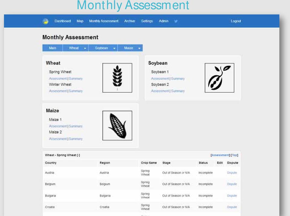
8 Monthly Assessment
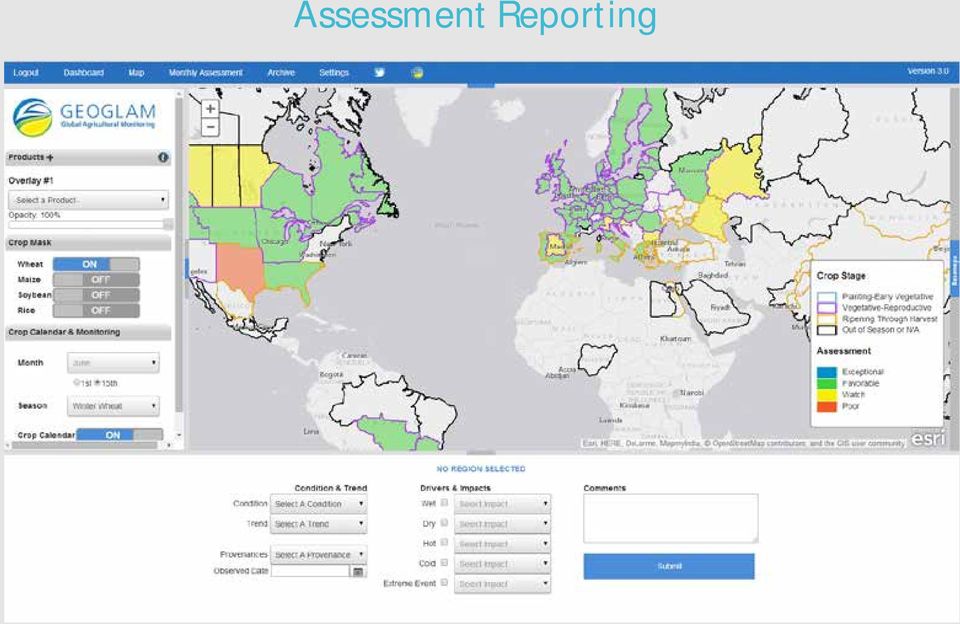
9 Assessment Reporting

10 Archive

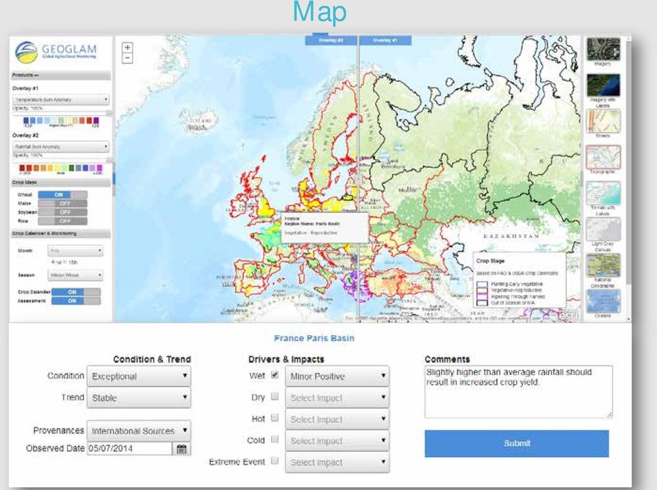
11 Map
12

13 Assessment Reporting
14

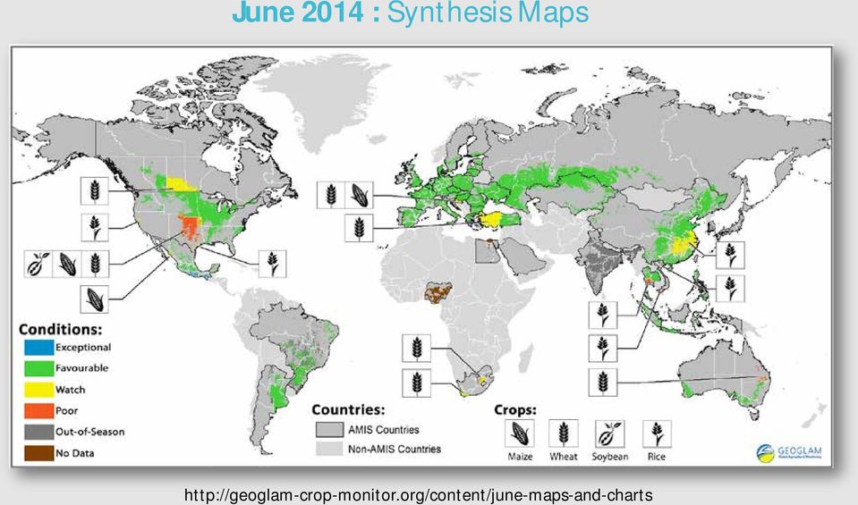
15 June 2014 : Synthesis Maps
16 June 2014 :Drivers and Impacts

17 Contributing to the Market Monitor

18 EO Data FAO UMD/NASA JRC JRC

19 Development

20 Description Tech Specs Development Phases: Version 1 Simple web map to visualize data layers NDVI Rain Sum Temperature Sum Crop Calendar Purpose: **Only to visualize data ArcGIS Server REST jquery HTML

21 Everything was hard coded
22 Early summer 2013
23 Development Phases: Version 2 Description Visualized data layers Use interface to collect data Purpose: Visualize dataset Collect Crop condition information Based on Crop Calendars Tech Specs ArcGIS Server REST jquery & Ajax Application functionality To make php requests PHP Query results from database MySQL Reference Table HTML
24 PHP Integration: Allowed server side functionality Allowed us to manipulate the interface dynamically. Data Collection Submission from client side to server side. Database Query s!!!!!!!!!!!!!!!!!!!! MySQL Database: Fast set up time Works great with PHP Great way to store REST URL ** Made things way easier for populating the interface User Login/ Registration New Challenge: Crop Calendars To many REST Services Performance Expandability
25
26 Development Phases: Version 3 Description Visualized data layers. Use interface to collect data Different levels of users Admin Reporters, etc. Dynamically store spatial data Data product expandability! Tech Specs ArcGIS Server REST jquery & Ajax Application functionality To make php requests PHP Query results from database PostgreSQL with SDE Relational DB model HTML
27 Enterprise-level database Leveraging the schemas Relational database model PostgreSQL PostgreSQL is perceived as more powerful, more focused on data integrity, and stricter at complying with SQL specifications, but correspondingly slower and more complicated to use.
28 ArcSDE Contains one master geometry table that defines the boundaries of the administrative units. The boundaries are used when visualizing the data. Using Databases views to connect geometry to other DB tables Complex Joins Data Export We are only storing the geometry once.
29 Proxy & Security
30 Code Examples
31
32 Thank You Technical Contact General Information
Spatial Database Support
 Page 1 of 11 Spatial Database Support Global Mapper can import vector data from and export vector data to the following spatial databases: Esri ArcSDE Geodatabase Esri File Geodatabase Esri Personal Geodatabases
GIS Databases With focused on ArcSDE
 Linköpings universitet / IDA / Div. for human-centered systems GIS Databases With focused on ArcSDE Imad Abugessaisa [email protected] 20071004 1 GIS and SDBMS Geographical data is spatial data whose
Chapter 1: Introduction to ArcGIS Server
 Chapter 1: Introduction to ArcGIS Server At a high level you can think of ArcGIS Server as software that helps you take your geographic information and make it available to others. This data can be distributed
Cookbook 23 September 2013 GIS Analysis Part 1 - A GIS is NOT a Map!
 Cookbook 23 September 2013 GIS Analysis Part 1 - A GIS is NOT a Map! Overview 1. A GIS is NOT a Map! 2. How does a GIS handle its data? Data Formats! GARP 0344 (Fall 2013) Page 1 Dr. Carsten Braun 1) A
ArcGIS 10.1 Geodatabase Administration. Gordon Sumerling & Christopher Brown
 ArcGIS 10.1 Geodatabase Administration Gordon Sumerling & Christopher Brown Key Improvements at ArcGIS 10.1 1. Easier Administration through Graphic Interfaces 2. Greater Seamless integration with Open
Pennsylvania Geospatial Data Sharing Standards (PGDSS) V 2.5
 V 2.5") Submitted to: Pennsylvania Geospatial Data Sharing Standards (PGDSS) V 2.5 Spatial Data Migration Tools Report May 2, 2007 Table of Contents 1.0 Document Purpose...B-1 2.0 Overview of Spatial Data Migration
Submitted to: Pennsylvania Geospatial Data Sharing Standards (PGDSS) V 2.5 Spatial Data Migration Tools Report May 2, 2007 Table of Contents 1.0 Document Purpose...B-1 2.0 Overview of Spatial Data Migration
DIPLOMA IN WEBDEVELOPMENT
 DIPLOMA IN WEBDEVELOPMENT Prerequisite skills Basic programming knowledge on C Language or Core Java is must. # Module 1 Basics and introduction to HTML Basic HTML training. Different HTML elements, tags
Leveraging Cartegraph Data for the Management of Public Works Assets for the City of Grapevine
 Leveraging Cartegraph Data for the Management of Public Works Assets for the City of Grapevine Presented By: Suja Joseph & Julie Paine Public Works City of Grapevine Overview of Cartegraph System for the
Geodatabase Programming with SQL
 DevSummit DC February 11, 2015 Washington, DC Geodatabase Programming with SQL Craig Gillgrass Assumptions Basic knowledge of SQL and relational databases Basic knowledge of the Geodatabase We ll hold
How To Use Arcgis For Free On A Gdb 2.2.2 (For A Gis Server) For A Small Business
 For A Small Business") Esri Middle East and Africa User Conference December 10 12 Abu Dhabi, UAE Understanding ArcGIS in Virtualization and Cloud Environments Marwa Mabrouk Powerful GIS capabilities Delivered as Web services
Esri Middle East and Africa User Conference December 10 12 Abu Dhabi, UAE Understanding ArcGIS in Virtualization and Cloud Environments Marwa Mabrouk Powerful GIS capabilities Delivered as Web services
ArcGIS. Server. A Complete and Integrated Server GIS
 ArcGIS Server A Complete and Integrated Server GIS ArcGIS Server A Complete and Integrated Server GIS ArcGIS Server enables you to distribute maps, models, and tools to others within your organization
Basics on Geodatabases
 Basics on Geodatabases 1 GIS Data Management 2 File and Folder System A storage system which uses the default file and folder structure found in operating systems. Uses the non-db formats we mentioned
GIS Architecture and Data Management Practices Boone County GIS Created and Maintained by the Boone County Planning Commission GIS Services Division
 GIS Architecture and Data Management Practices Boone County GIS Created and Maintained by the Boone County Planning Commission June 2008 Background Boone County s GIS program has been in existence for
Sisense. Product Highlights. www.sisense.com
 Sisense Product Highlights Introduction Sisense is a business intelligence solution that simplifies analytics for complex data by offering an end-to-end platform that lets users easily prepare and analyze
A Web services solution for Work Management Operations. Venu Kanaparthy Dr. Charles O Hara, Ph. D. Abstract
 A Web services solution for Work Management Operations Venu Kanaparthy Dr. Charles O Hara, Ph. D Abstract The GeoResources Institute at Mississippi State University is leveraging Spatial Technologies and
Developing Business Intelligence and Data Visualization Applications with Web Maps
 Developing Business Intelligence and Data Visualization Applications with Web Maps Introduction Business Intelligence (BI) means different things to different organizations and users. BI often refers to
Case Study. Insurance Plan Management System with Mobility. www.brainvire.com 2016 Brainvire Infotech Pvt. Ltd Page 1 of 1
 Case Study Insurance Plan Management System with Mobility www.brainvire.com 2016 Brainvire Infotech Pvt. Ltd Page 1 of 1 Client Requirement The client is an insurance plan provider offering warranty protection
Enterprise GIS Solutions to GIS Data Dissemination
 Enterprise GIS Solutions to GIS Data Dissemination ESRI International User Conference July 13 17, 2009 Wendy M. Turner Senior GIS Engineer & Program Manager Freedom Consulting Group, LLC Building the Enterprise
Supported DBMS platforms DB2. Informix. Enterprise ArcSDE Technology. Oracle. GIS data. GIS clients DB2. SQL Server. Enterprise Geodatabase 9.
 ArcSDE Administration for PostgreSQL Ale Raza, Brijesh Shrivastav, Derek Law ESRI - Redlands UC2008 Technical Workshop 1 Outline Introduce ArcSDE technology for PostgreSQL Implementation PostgreSQL performance
Lecture 8. Online GIS
 Lecture 8 Online GIS Lecture 8: Outline I. Online GIS 1. Google Earth 2. MSN Live Maps II. Open Source GIS III. ArcGIS Server and the ESRI suite of online software utility options IV. Advanced Data Mining
Texas Develops Online Geospatial Data Repository to Support Emergency Management
 Bing Maps for Enterprise Microsoft Customer Solution Case Study Texas Develops Online Geospatial Data Repository to Support Emergency Management Overview Country or Region: United States Industry: Government
Adam Rauch Partner, LabKey Software [email protected]. Extending LabKey Server Part 1: Retrieving and Presenting Data
 Adam Rauch Partner, LabKey Software [email protected] Extending LabKey Server Part 1: Retrieving and Presenting Data Extending LabKey Server LabKey Server is a large system that combines an extensive set
ArcGIS Data Models Practical Templates for Implementing GIS Projects
 ArcGIS Data Models Practical Templates for Implementing GIS Projects GIS Database Design According to C.J. Date (1995), database design deals with the logical representation of data in a database. The
Institute of Computational Modeling SB RAS
 Institute of Computational Modeling SB RAS ORGANIZATION OF ACCESS TO OBSERVATIONAL DATA USING WEB SERVICES FOR MONITORING SYSTEMS THE STATE OF THE ENVIRONMENT Kadochnikov Aleksey A. Russia, Krasnoyarsk
Big Data and Analytics: Getting Started with ArcGIS. Mike Park Erik Hoel
 Big Data and Analytics: Getting Started with ArcGIS Mike Park Erik Hoel Agenda Overview of big data Distributed computation User experience Data management Big data What is it? Big Data is a loosely defined
DATA SHARING AND SPATIAL QUERY
 Technical Memorandum No. 2 DATA SHARING AND SPATIAL QUERY Raghavan Srinivasan Spatial Sciences Laboratory Texas Agricultural Experiment Station, Texas A&M University Submitted to El Paso Water Utilities
OIT 307/ OIT 218: Web Programming
 OIT 307/ OIT 218: Web Programming 1.0 INTRODUCTION Many applications nowadays work really well as a web application. Web programming is the practice of writing applications that run on a web server and
CERN Summer Student Program 2013 Report
 CERN Summer Student Program 2013 Report Stanislav Pelák E-mail: [email protected] / [email protected] Abstract. This report describes the work and achievements of Stanislav Pelák, during his stay
ESRI Technical Certification Overview. Amy Daniels Instructor, Greenville Tech
 ESRI Technical Certification Overview Amy Daniels Instructor, Greenville Tech Why have certification by ESRI? It communicates your proficiency in ESRI software Similar to Microsoft Certification, it can
ArcSDE Spatial Data Management Roles and Responsibilities
 ArcSDE Spatial Data Management Roles and The following discussion outlines the major roles and responsibilities involved in deploying your spatial data and geographic information system (GIS) applications
Implementing a Web-based Transportation Data Management System
 Presentation for the ITE District 6 Annual Meeting, June 2006, Honolulu 1 Implementing a Web-based Transportation Data Management System Tim Welch 1, Kristin Tufte 2, Ransford S. McCourt 3, Robert L. Bertini
Oracle Application Express MS Access on Steroids
 Oracle Application Express MS Access on Steroids Jules Lane Principal Consultant Tactical Database Development options Spreadsheets Encourage data duplication and inconsistency, clog
HTML5. Turn this page to see Quick Guide of CTTC
 Programming SharePoint 2013 Development Courses ASP.NET SQL TECHNOLGY TRAINING GUIDE Visual Studio PHP Programming Android App Programming HTML5 Jquery Your Training Partner in Cutting Edge Technologies
GIS AS A DECISION SUPPORT FOR SUPPLY CHAIN MANAGEMENT
 Paper Reference No.: PN-253 GIS AS A DECISION SUPPORT FOR SUPPLY CHAIN MANAGEMENT Sanjay Kumar 1 and Suneeta Agrawal 2 1. M. Tech. (GIS & Remote Sensing); GIS Cell; MNNIT, Allahabad, India (E-mail: [email protected])
!"#$%&%'($)*+,-",!./01#'/",'",234045'0'#6,4"7, 21&&/%#,
*+,-,!./01#'/,',234045'0'#6,47, 21&&/%#,") !"#$%&%'($)*+,-",!./01#'/",'",234045'0'#6,4"7, 21&&/%#, Judith Hurwitz A HURWITZ Perspective 1 1 Copyright 2009, Hurwitz & Associates 2 2 All rights reserved. No part of this publication may be reproduced
!"#$%&%'($)*+,-",!./01#'/",'",234045'0'#6,4"7, 21&&/%#, Judith Hurwitz A HURWITZ Perspective 1 1 Copyright 2009, Hurwitz & Associates 2 2 All rights reserved. No part of this publication may be reproduced
Case Study. SaaS Based Multi-Store Market Place. www.brainvire.com 2013 Brainvire Infotech Pvt. Ltd Page 1 of 5
 Case Study SaaS Based Multi-Store Market Place Page 1 of 5 Client Requirement Magento Multi-Store Ecommerce Management is a web based virtual mall. It s an e- commerce virtual mall cum SaaS based model
Izenda & SQL Server Reporting Services
 Izenda & SQL Server Reporting Services Comparing an IT-Centric Reporting Tool and a Self-Service Embedded BI Platform vv Izenda & SQL Server Reporting Services The reporting tools that come with the relational
PHP and MongoDB Web Development Beginners Guide by Rubayeet Islam
 PHP and MongoDB Web Development Beginners Guide by Rubayeet Islam Projects-Oriented Book Combine the power of PHP and MongoDB to build dynamic web 2.0 applications Learn to build PHP-powered dynamic web
How To Use The Alabama Data Portal
 113 The Alabama Metadata Portal: http://portal.gsa.state.al.us By Philip T. Patterson Geological Survey of Alabama 420 Hackberry Lane P.O. Box 869999 Tuscaloosa, AL 35468-6999 Telephone: (205) 247-3611
[ DISTRIBUTING AVL USING ARCIMS
 [ DISTRIBUTING AVL USING ARCIMS The Chicago MAGIC Project ] GIS-T 2003 Colorado Springs presented by Louis Schoolkate Transportation Division Manager GeoAnalytics, Inc. 2002 [ Presentation Overview ] Project
SUMMER SCHOOL ON ADVANCES IN GIS
 SUMMER SCHOOL ON ADVANCES IN GIS Six Workshops Overview The workshop sequence at the UMD Center for Geospatial Information Science is designed to provide a comprehensive overview of current state-of-the-art
Esri Maps for Business Intelligence (BI)
") 2013 Esri International User Conference July 8 12, 2013 San Diego, California Technical Workshop Esri Maps for Business Intelligence (BI) Pierre Seguin Patrick Brennan Esri UC2013. Technical Workshop.
2013 Esri International User Conference July 8 12, 2013 San Diego, California Technical Workshop Esri Maps for Business Intelligence (BI) Pierre Seguin Patrick Brennan Esri UC2013. Technical Workshop.
GeoManitoba Spatial Data Infrastructure Update. Presented by: Jim Aberdeen Shawn Cruise
 GeoManitoba Spatial Data Infrastructure Update Presented by: Jim Aberdeen Shawn Cruise Organization Overview Manitoba Innovation Energy and Mines Business Transformation and Technology (BTT) Application
Configuring an Alternative Database for SAS Web Infrastructure Platform Services
 Configuration Guide Configuring an Alternative Database for SAS Web Infrastructure Platform Services By default, SAS Web Infrastructure Platform Services is configured to use SAS Framework Data Server.
ArcGIS Server Best Practices and Guidelines
 ArcGIS Server Best Practices and Guidelines NEARC 2007 ESRI Technical Session ESRI, Boston Agenda Components and Deployment OS User Groups and Directory Configuration Service Architectures GIS Security
The Importance of Data Quality in your Enterprise
 Federal GIS Conference February 9 10, 2015 Washington, DC The Importance of Data Quality in your Enterprise Heather Murnane & Sherry Fagin Workshop Agenda Importance of Data Quality What is ArcGIS Data
ArcGIS for. Intelligence
 ArcGIS for ArcGIS for solutions.arcgis.com/intelligence Copyright 2015 Esri. All rights reserved. 146660 DUAL3M7/15rk Briefing Book ArcGIS for Briefing Book ArcGIS Web Application ArcGIS for Create and
ARIZONA DEPARTMENT OF TRANSPORTATION. Presented by Lonnie D. Hendrix, P.E. Assistant State Engineer, Maintenance
 ARIZONA DEPARTMENT OF TRANSPORTATION Presented by Lonnie D. Hendrix, P.E. Assistant State Engineer, Maintenance Prepared by Feature Inventory Services Team July 2013 FIS Database Feature Inventory System
Harvard Data Visualization Project
 Esri User Conference, July 12-15, San Diego California Harvard Data Visualization Project Spatio-Temporal Visualization of Global Phenomena: 1850 to the Present Harvard Business School Geoffrey Jones Walter
NatureServe s Environmental Review Tool
 NatureServe s Environmental Review Tool A Repeatable Online Software Solution for Agencies For More Information, Contact: Lori Scott Rob Solomon [email protected] [email protected] 703-908-1877
GIS: Geographic Information Systems A short introduction
 GIS: Geographic Information Systems A short introduction Outline The Center for Digital Scholarship What is GIS? Data types GIS software and analysis Campus GIS resources Center for Digital Scholarship
Scientific Data Management and Dissemination
 Federal GIS Conference February 9 10, 2015 Washington, DC Scientific Data Management and Dissemination John Fry Solution Engineer, Esri [email protected] Agenda Background of Scientific Data Management through
GIS Initiative: Developing an atmospheric data model for GIS. Olga Wilhelmi (ESIG), Jennifer Boehnert (RAP/ESIG) and Terri Betancourt (RAP)
, Jennifer Boehnert (RAP/ESIG) and Terri Betancourt (RAP)") GIS Initiative: Developing an atmospheric data model for GIS Olga Wilhelmi (ESIG), Jennifer Boehnert (RAP/ESIG) and Terri Betancourt (RAP) Unidata seminar August 30, 2004 Presentation Outline Overview
GIS Initiative: Developing an atmospheric data model for GIS Olga Wilhelmi (ESIG), Jennifer Boehnert (RAP/ESIG) and Terri Betancourt (RAP) Unidata seminar August 30, 2004 Presentation Outline Overview
INTEROPERABLE IMAGE DATA ACCESS THROUGH ARCGIS SERVER
 INTEROPERABLE IMAGE DATA ACCESS THROUGH ARCGIS SERVER Qian Liu Environmental Systems Research Institute 380 New York Street Redlands, CA92373, U.S.A - [email protected] KEY WORDS: OGC, Standard, Interoperability,
ArcGIS Reference Document
 Migration of GIS Data to ArcSDE Page 1 of 10 Table of Contents A Brief Summary of DEP s GIS Data Storage o The Y Drive o ArcSDE (Spatial Database) Keeping Your GIS Project Data Current o Checking Your
Analysing Big Data in ArcGIS
 OIL & GAS Analysing Big Data in ArcGIS AIS based risk modelling Esri European Petroleum GIS Conference 2014 Karl John Pedersen 7th November 2014 1 DNV GL 2014 7th November 2014 SAFER, SMARTER, GREENER
Administering Your Microsoft SQL Server Geodatabase
 Administering Your Microsoft SQL Server Geodatabase Shannon Shields Chet Dobbins Esri UC 2014 Technical Workshop Agenda News since the last UC How do I - Configure SQL Server to support geodatabases? -
GIS: Transforming the Business. Presented by: Catherine Fitzgerald Manager, Information Services Municipality of Chatham-Kent
 GIS: Transforming the Business Presented by: Catherine Fitzgerald Manager, Information Services Municipality of Chatham-Kent Organization Overview Municipality of Chatham-Kent Single Tier Local Government
Spatial data models (types) Not taught yet
 Not taught yet") Spatial data models (types) Not taught yet A new data model in ArcGIS Geodatabase data model Use a relational database that stores geographic data A type of database in which the data is organized across
Spatial data models (types) Not taught yet A new data model in ArcGIS Geodatabase data model Use a relational database that stores geographic data A type of database in which the data is organized across
graphics Dezino Graphics Tel:. +91 99301 87365 Email:. [email protected] URL.: www.dezinographics.in Web Design Packages Shopping Cart Packages
 Web Design Packages Starter 1 Page Website $75 Only Go Get It 3 Page Website Online Contact US form $100 Only Do More 5 Page Website Online Contact US form $199 Only Do More Plus 5 to 15 Pages Website
Choosing the right GIS framework for an informed Enterprise Web GIS Solution
 13 ANNUAL INTERNATIONAL CONFERENCE AND EXHIBITION ON GEOSPATIAL INFORMATION TECHNOLOGY AND APPLICATIONS Epicentre; Gurgaon, India; 19-21 January, 2010 Choosing the right GIS framework for an informed Enterprise
Database Web Development ITP 300 (3 Units)
") Database Web Development ITP 300 (3 Units) Fall 2014 Section 32031R Objective In this class students will learn to build dynamic, database- driven web sites. They will learn how to structure content for
Database Web Development ITP 300 (3 Units) Fall 2014 Section 32031R Objective In this class students will learn to build dynamic, database- driven web sites. They will learn how to structure content for
To increase scalability, the following features can be integrated:
 Client Requirements Magento Multi Store Ecommerce Management system is an online virtual mall using is Saas based model based Ecommerce Platform where merchants and retailers can sign up and easily create
MARICOPA COUNTY ASSESSOR S OFFICE
 AARON JUDY, GISP Esri Certified Enterprise Geodatabase Management Professional GIS Certification Institute (GISCI) GIS Professional Certification Certified Scrum Master Ninja (No, really!) MARICOPA COUNTY
Novell File Reporter 2.5 Who Has What?
 Novell File Reporter 2.5 Who Has What? Richard Cabana Senior Systems Engineer File Access & Mgmt Solution Principal Attachmate Novell North America [email protected] Joe Marton Senior Systems Engineer
Administering your PostgreSQL Geodatabase
 Jim Gough and Jim McAbee [email protected] [email protected] Agenda Workshop will be structured in 2 parts Part 1: Scenario Using Postgres for your Enterprise Geodatabase and how to get started. Part 2: Advanced
A Tool for Evaluation and Optimization of Web Application Performance
 A Tool for Evaluation and Optimization of Web Application Performance Tomáš Černý 1 [email protected] Michael J. Donahoo 2 [email protected] Abstract: One of the main goals of web application
White Paper. Freeance Mobile for Cityworks
 White Paper Freeance Mobile for Cityworks Version 1.1 May 2012 Freeance Mobile for Cityworks Freeance Mobile for Cityworks 2012.1 is a mobile application for the following smartphones and tablets: iphone
Certified PHP/MySQL Web Developer Course
 Course Duration : 3 Months (120 Hours) Day 1 Introduction to PHP 1.PHP web architecture 2.PHP wamp server installation 3.First PHP program 4.HTML with php 5.Comments and PHP manual usage Day 2 Variables,
Release Notes. Postgres Plus Solution Pack v9.1
 Release Notes Solution Pack v9.1 Table of Contents I. Release Summary...1 II. Solution Pack Component Release Notes...2 III. PostgreSQL Release Notes...4 IV. Solution Pack Documentation...4 V. Platform
Connect to MySQL or Microsoft SQL Server using R
 Connect to MySQL or Microsoft SQL Server using R 1 Introduction Connecting to a MySQL database or Microsoft SQL Server from the R environment can be extremely useful. It allows a research direct access
How To Use Gis
 Welcome Understanding Purpose Creating Relationships You A Global Community of GIS Professionals Changing the World Together Applying Geography Everywhere Your WORK Showcasing Your Web Apps Vision Applying
ArcGIS Server 9.3.1 mashups
 Welcome to ArcGIS Server 9.3.1: Creating Fast Web Mapping Applications With JavaScript Scott Moore ESRI Olympia, WA [email protected] Seminar agenda ArcGIS API for JavaScript: An Overview ArcGIS Server Resource
ECOMMERCE SITE LIKE- GRAINGER.COM
 12/19/2012 ITFLEXSOLUTIONS ECOMMERCE SITE LIKE- GRAINGER.COM Developed by : IT Flex Solutions www.itflexsolutions.com *Please note that this is not a final proposal only an estimate of the time and type
How We Did It. Unique data model abstraction layer to integrate, but de-couple EHR data from patient website design.
 EHR Accessibility The Big Idea: Provide a standardized and improved user experience for ALL disabled and abled patients while interacting with their providers Electronic Health Records System (EHR). The
Developing Fleet and Asset Tracking Solutions with Web Maps
 Developing Fleet and Asset Tracking Solutions with Web Maps Introduction Many organizations have mobile field staff that perform business processes away from the office which include sales, service, maintenance,
Remote Sensing Image Server for GMS (Greater Mekong Sub-Region) Countries
 Countries") Remote Sensing Image Server for GMS (Greater Mekong Sub-Region) Countries Kiyoshi HONDA, Sarawut Ninsawat, Teerayut Horanont, Ryuzo Yokoyama, Amor V.M. Ines Space Technology Applications and Research (STAR)
Remote Sensing Image Server for GMS (Greater Mekong Sub-Region) Countries Kiyoshi HONDA, Sarawut Ninsawat, Teerayut Horanont, Ryuzo Yokoyama, Amor V.M. Ines Space Technology Applications and Research (STAR)
General principles and architecture of Adlib and Adlib API. Petra Otten Manager Customer Support
 General principles and architecture of Adlib and Adlib API Petra Otten Manager Customer Support Adlib Database management program, mainly for libraries, museums and archives 1600 customers in app. 30 countries
Overview of Databases On MacOS. Karl Kuehn Automation Engineer RethinkDB
 Overview of Databases On MacOS Karl Kuehn Automation Engineer RethinkDB Session Goals Introduce Database concepts Show example players Not Goals: Cover non-macos systems (Oracle) Teach you SQL Answer what
An Esri White Paper October 2010 Esri Production Mapping Product Library: Spatially Enabled Document Management System
 An Esri White Paper October 2010 Esri Production Mapping Product Library: Spatially Enabled Document Management System Esri, 380 New York St., Redlands, CA 92373-8100 USA TEL 909-793-2853 FAX 909-793-5953
Students who successfully complete the Health Science Informatics major will be able to:
 Health Science Informatics Program Requirements Hours: 72 hours Informatics Core Requirements - 31 hours INF 101 Seminar Introductory Informatics (1) INF 110 Foundations in Technology (3) INF 120 Principles
Using Microsoft Business Intelligence Dashboards and Reports in the Federal Government
 Using Microsoft Business Intelligence Dashboards and Reports in the Federal Government A White Paper on Leveraging Existing Investments in Microsoft Technology for Analytics and Reporting June 2013 Dev
Editing Strategies for Enterprise Geodatabase
 Federal GIS Conference February 9 10, 2015 Washington, DC Editing Strategies for Enterprise Geodatabase Ty Fabling Esri Solution Engineer A Complete Platform Enabling GIS Everywhere Desktop Web Device
Build an ArcGIS Online Application
 Build an ArcGIS Online Application Sign into ArcGIS Online for Maryland 1. Open a web browser 2. Go to URL http://maryland.maps.arcgis.com/ 3. Click Sign In in the upper right corner of the web page 4.
AV-18 Introduction of the GIS Integration
 Slide 1 AV-18 Introduction of the GIS Integration Authors Victor Lough Dan Marsillo Geoff Tarcha social.invensys.com @InvensysOpsMgmt / #SoftwareRevolution /InvensysVideos /InvensysOpsMgmt /company/invensys
Data Validation Online References
 Data Validation Online References Submitted To: Program Manager GeoConnections Victoria, BC, Canada Submitted By: Jody Garnett Brent Owens Refractions Research Inc. Suite 400, 1207 Douglas Street Victoria,
How to connect to ArcSDE spatial database using OpenOffice and Microsoft Office suites
 How to connect to ArcSDE spatial database using OpenOffice and Microsoft Office suites I. Introduction The use of GIS specific software does not limit the input of non-gis users. Current office suites
What is GIS? Geographic Information Systems. Introduction to ArcGIS. GIS Maps Contain Layers. What Can You Do With GIS? Layers Can Contain Features
 What is GIS? Geographic Information Systems Introduction to ArcGIS A database system in which the organizing principle is explicitly SPATIAL For CPSC 178 Visualization: Data, Pixels, and Ideas. What Can
Version 1.6. MDweb installation and configuration (scripts databases) Linux Platform. 1.3 Authors: Jean Christophe Desconnets (jcd@teledetection.
 Linux Platform. 1.3 Authors: Jean Christophe Desconnets (jcd@teledetection.") Version 1.6 MDweb installation and configuration (scripts databases) Linux Platform Version Comments 1 Authors : Jean Christophe Desconnets ([email protected]) Translation : Kim Agrawal ([email protected])
Version 1.6 MDweb installation and configuration (scripts databases) Linux Platform Version Comments 1 Authors : Jean Christophe Desconnets ([email protected]) Translation : Kim Agrawal ([email protected])
TG Web. Technical FAQ
 TG Web Technical FAQ About this FAQ We encourage you to contact us if. You can't find the information you're looking for. You would like to discuss your specific testing requirements in more detail. You
Course Title: Reporting in Microsoft Dynamics CRM 2011
 Course Code: SSM80445 Course Title: Reporting in Microsoft Dynamics CRM 2011 Duration: 1 Day About this Course This one-day instructor-led course, Reporting in Microsoft Dynamics CRM 2011, provides students
Creating a GIS based learning tool for the Faculty of Forest & Environment at the HNE Eberswalde
 Creating a GIS based learning tool for the Faculty of Forest & Environment at the HNE Eberswalde G. Singelnstein / H. Plesse University of Applied Sciences in Eberswalde 14.04.2011 Introduction I What