University of Arkansas Libraries ArcGIS Desktop Tutorial. Section 4: Preparing Data for Analysis
|
|
|
- Oliver Webb
- 7 years ago
- Views:
Transcription
1 : Preparing Data for Analysis When a user acquires a particular data set of interest, it is rarely in the exact form that is needed during analysis. This tutorial describes how to change the data to make it more appropriate to the scope of the project. Data can be prepared using ArcToolbox accessible through either ArcCatalog or ArcMap for the purposes of this tutorial we have chosen to use ArcMap to interface with ArcToolbox. Selecting Features: It is often the case that we are only interested in a particular feature or features of an acquired data set and that the others are unnecessary to our purposes. We can extract only those features we need by selecting them and saving them in a new output feature class. To select a feature of interest, the user must click the ArcToolbox Analysis Tools menu followed by Extract and then Select. Page 1

2 Page 2
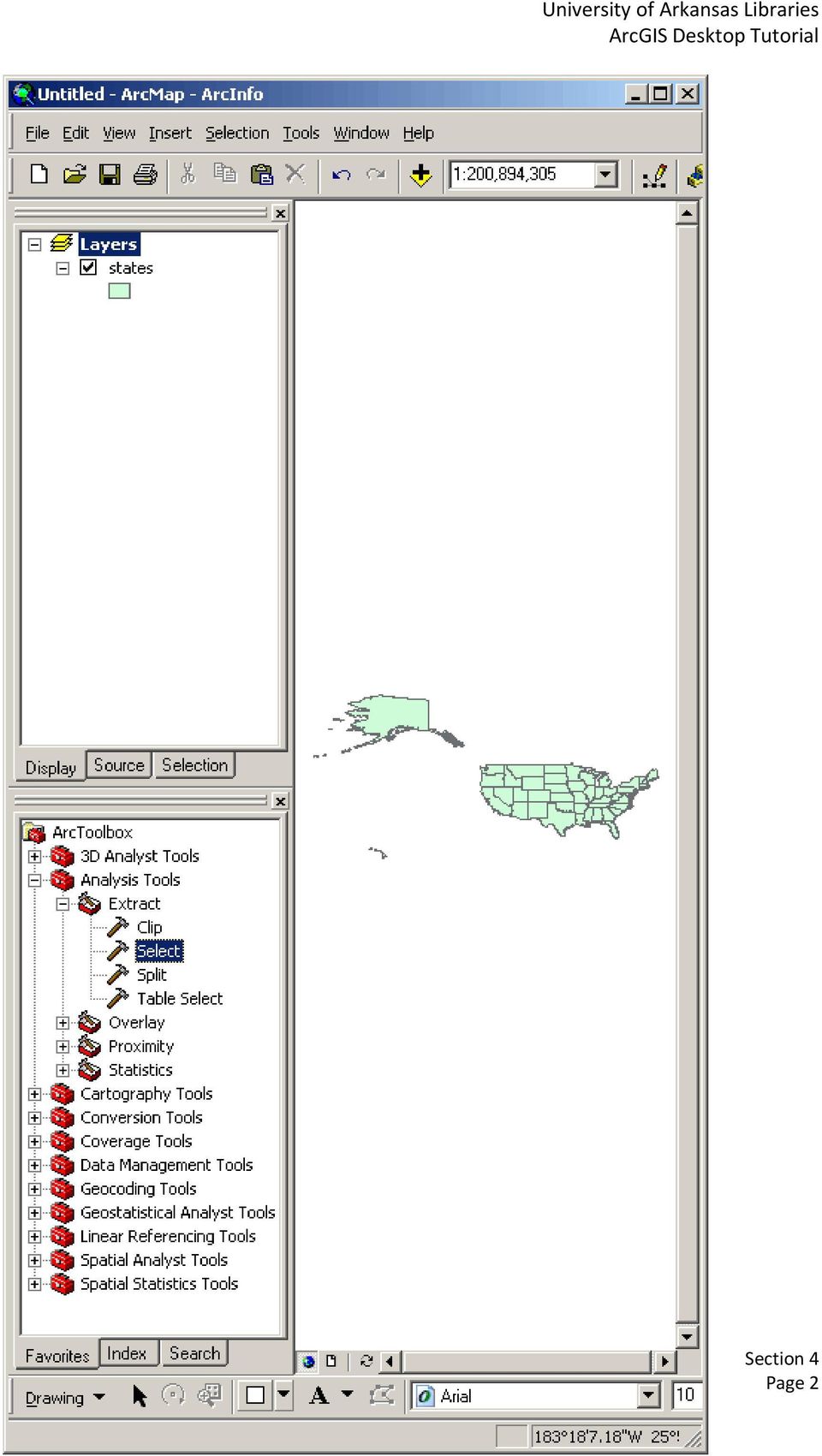
3 The Select tool dialog box opens. In the Select tool dialog box, you may select the Input Features from the drop down menu or browse to the feature. After specifying a name and location for the Output Feature Class move next to the Expression option. If you are not familiar or don't know the fields with which to structure an expression use the Query Builder accessible through the SQL button. From the list of fields, operators, and unique values put together an SQL query statement to select which features you want. Once the statement has been formulated, the OK button on the Query Builder should be clicked. Then the OK button on the Select dialog box. The output is automatically added to the map display. If the user wishes to learn more about the dissolve operation, the Help button should be selected. Page 3

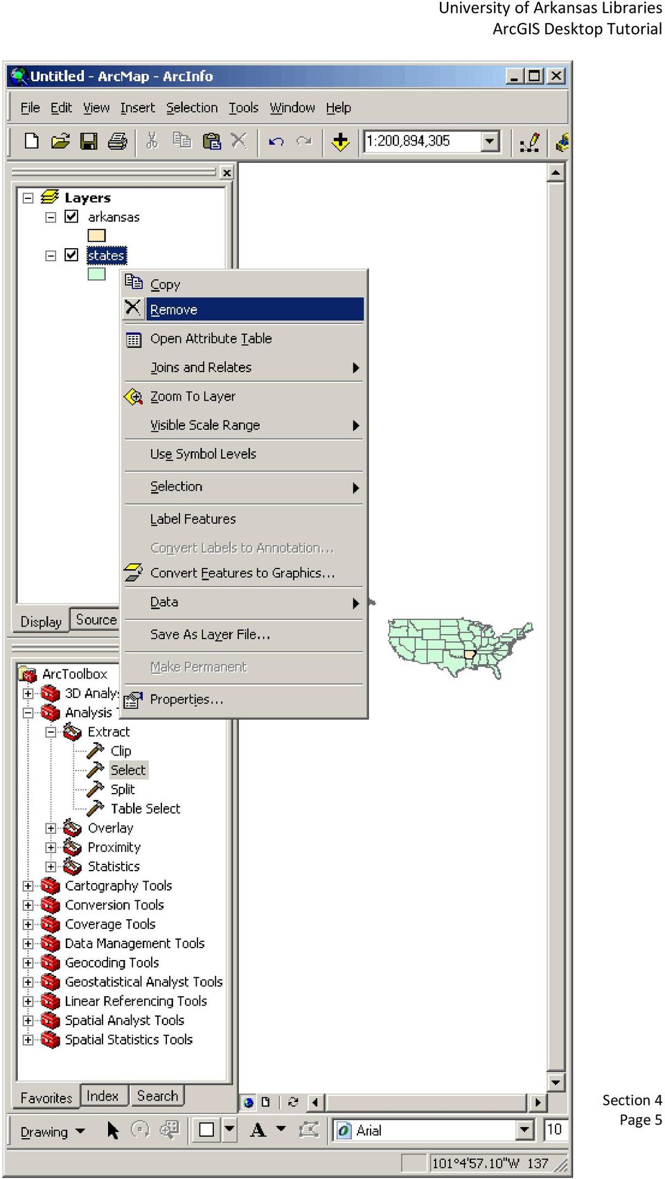
4 Remove the layer that you are no longer in need of by performing a right mouse click and selecting Remove from the pop up menu. Page 4

5 Page 5
6 Clipping Features: Sometimes the acquired data sets cover a greater area than the user is interested in. The data set can be clipped to the area of interest by using features in one layer to clip the features in another layer. To clip one layer based on another, the user must us Clip found in the Extract portion of Analysis Tools in ArcToolbox. Here the msa features outside the arkansas feature are not needed are therefore considered the Input Features. The arkansas features are the Clip Features or the polygon clip layer. A output shapefile or feature class should be selected, and the Finish button should be clicked. The clipped layer will appear in the ArcMap display. Page 6

7 To find out more about the Clip operation, the Help button can be clicked. In the following example a state of Arkansas polygon was used to clip a Metropolitan Statistical Area layer. The resulting layer is a clipped msa layer that only shows the Metropolitan Statistical Areas in Arkansas. Page 7

8 Page 8

9 Page 9

10 Dissolving Features: Dissolve is another tool used to trim away unnecessary detail that is not relevant to the scope of the project. Data can be simplified by dissolving several features in a layer into one. To dissolve multiple features into one, the user must click the ArcToolbox Data Management Tools menu followed by Generalization and then Dissolve. Page 10

11 Page 11

12 The Dissolve tool dialog box opens. In the Dissolve dialog box, you may select the Input Features from the drop down menu or browse to the feature. After specifying a name and location for the Output Feature Class move next to the Dissolve_Field(s) option. From the list of attributes select one or more on which to dissolve. Once selected, the OK button should be selected. The output is automatically added to the map display. If the user wishes to learn more about the dissolve operation, the Help button should be selected. Page 12

13 In the following example, boundaries separating adjoining Arkansas' MSAs (Metropolitan Statistical Area) were dissolved so that there would be no distinction between individual MSAs. Page 13

14 Page 14

15 Exporting Data: Using ArcMap, a user is capable of exporting a new data set from an existing one that contains selected features. As mentioned in the section three tutorial, once features have been selected the user can choose to create an ArcMap layer of only the selected features within a dataset. This is valuable for quick manipulation of datasets. However, if the user wishes to use this new layer within other ArcGIS applications, the selected features should actually be EXPORTED as a real dataset, instead of a layer that will only exist in ArcMap. Selected features within a dataset can be exported by right clicking on the data layer in the table of contents that contain the selected features the user wishes to export. Next, the user must point to the Data menu, and click Export Data. The Export Data Dialog Box appears. The Export drop down list is set to the Selected Features option. This is the correct option if the user wishes to export the selected features within an existing data set. The other options allow the user to export all features or all features within the view extent. Once the correct export option is chosen, the user must specify whether the new data set should have the same Coordinate System as the layer's source data, or the same Coordinate Systems as the data frame. Next, an output file path and name should be chosen, and the OK button should be clicked. Once the user clicks the OK button, ArcMap exports the features to a new feature class and prompts the user to add the exported data to the ArcMap display. Projecting Data for Display in ArcMap: A data layer's coordinate system information can be found by viewing its spatial metadata. When data sets have the same coordinate system they are correctly positioned with respect to each other in the data frame. If a data set is added to an ArcMap display that has a different coordinate system from those layers that have already been added to the data frame, ArcMap automatically changes its display so that it matches the existing layers. This change is only temporary and only exists within a particular data frame. The underlying coordinate system information DOES NOT change. Page 15

16 Projecting and Defining the Coordinate System or Spatial Reference: Though one of the principal features of ArcGIS Desktop is the ability to change a dataset, feature class, or raster file's projection "on the fly" for display and analysis purposes, if the user acquires data sets with different coordinate systems or projections, the user may wish to change them so that they all match. A user can project data to a new data set using ArcToolbox Project for features and Project Raster for raster files, or the user can define or change the projection and coordinate system of a data set using Define Projection. To project or define a projection or project data, the user must click the plus sign next to Data Management Tools, followed by a click on the plus sign next to Projections and Transformations. Page 16

17 Page 17

18 Project and Project Raster reproject input data and saves it as a new data set. Project allows the user to define or project feature classes and geodatabases. Project Raster allows the user to define or project coverages, grids, or TINs. The Define Projection tool applys coordinate system information to data sets and feature classes. For example, if the user wishes to project a feature class the Project tool (shapefiles, geodatabases) should be opened by double clicking on the option in ArcToolbox. Once the Project dialog box opens, the user must select the data set to define. This can be done by clicking the folder icon and navigating to the shapefile or geodatabase of interest. Once the data set name has been added to the dialog, the Output Coordinate System must be selected. To select a coordinate system click on the Spatial Reference Properties button highlighted by the red circle in the graphic above. The Spatial Reference Properties dialog box appears. Page 18

19 Within this dialog box, the user can select a predefined coordinate system, import a coordinate system from another data set, or create a new coordinate system. Once a coordinate system has been selected, the Spatial Reference Properties dialog box will be updated with the details of the selected coordinate system. Page 19

20 When the user clicks OK, the Output Coordinate System name appears in the Project dialog box. Page 20

21 Clicking OK produces a new data set with a different coordinate system. The new data set is automatically added to the list of layers. Though the new data set is a different coordinate system than the other layers it has been reprojected on the fly to match the other layers on screen. Page 21
University of Arkansas Libraries ArcGIS Desktop Tutorial. Section 5: Analyzing Spatial Data. Buffering Features:
 : Analyzing Spatial Data Buffering Features: A buffer operation is one of the most common spatial analysis tools. A buffer is a map feature that represents a uniform distance around a feature. When creating
Exercise 3: Building a GIS data library
 The Scenario You are preparing for an interview for a GIS position for a particular county. They asked that you present a GIS demonstration as part of your interviewing process. You decide to develop a
Personal Geodatabase 101
 Personal Geodatabase 101 There are a variety of file formats that can be used within the ArcGIS software. Two file formats, the shape file and the personal geodatabase were designed to hold geographic
1. Launch ArcCatalog, then navigate to the following location using the directory tree on the left side of the screen:
 Vector Data Analysis I: Buffering Today we will use ArcMap and ArcToolbox to manipulate vector-based geographic data. The results of these simple analyses will allow us to visualize complex spatial relationships.
RS/GIS Quick Start Guides Collaborative training materials available from the Biodiversity Informatics & Geospatial Innovation Facilities
 http://gif.berkeley.edu Collaborative training materials available from the Biodiversity Informatics & Geospatial Innovation Facilities http://biodiversityinformatics.amnh.org Using the ArcMap model builder
Knowledgebase Article
 Company web site: Support email: Support telephone: +44 20 3287-7651 +1 646 233-1163 2 EMCO Network Inventory 5 provides a built in SQL Query builder that allows you to build more comprehensive
Software: AutoCAD Civil 3D 2014, NRCS C3D 2014 template, ESRI ArcMap. Notation:Button to Press Displayed Text Icon Action {Text to Enter} Menu Item
 Overview: Use the following processes for exchanging georeferenced data between AutoCAD Civil 3D 2014 and ArcMap. The work must be based in any real world coordinate system. (This example uses NAD 83 UTM
Converting GIS Datasets into CAD Format
 Ball State University Libraries GIS Research and Map Collection Converting GIS Datasets into CAD Format Author: Angela Gibson, 6/13/2014 Overview: One of the most common requests from students is for GIS
Creating a File Geodatabase
 Creating a File Geodatabase Updated by Thomas Stieve January 06, 2012 This exercise demonstrates how to create a file geodatabase in ArcGIS 10; how to import existing data into the geodatabase, and how
Government 1008: Introduction to Geographic Information Systems. LAB EXERCISE 4: Got Database?
 Government 1008: Introduction to Geographic Information Systems Objectives: Creating geodatabases Joining attribute tables Attribute and location based queries Spatial joins Creating spatial and attribute
GEOGRAPHIC INFORMATION SYSTEMS Lecture 20: Adding and Creating Data
 Adding Existing Data Into ArcGIS - there are many different ways to get data into ArcGIS GEOGRAPHIC INFORMATION SYSTEMS Lecture 20: Adding and Creating Data Add Data - normally we use the Add Data button
INTRODUCTION to ESRI ARCGIS For Visualization, CPSC 178
 INTRODUCTION to ESRI ARCGIS For Visualization, CPSC 178 1) Navigate to the C:/temp folder 2) Make a directory using your initials. 3) Use your web browser to navigate to www.library.yale.edu/mapcoll/ and
Geocoding and Buffering Addresses in ArcGIS
 INTRODUCTION and Buffering Addresses in ArcGIS is the process of assigning location coordinates in a continuous, globlal reference system (Latitude and Longitude, for instance) to street addresses. While
Downloading SSURGO Soil Data from Internet
 Downloading SSURGO Soil Data from Internet Prepared by Venkatesh Merwade School of Civil Engineering, Purdue University vmerwade@purdue.edu September 2012 Purpose The purpose of this exercise to demonstrate
Spatial Database Support
 Page 1 of 11 Spatial Database Support Global Mapper can import vector data from and export vector data to the following spatial databases: Esri ArcSDE Geodatabase Esri File Geodatabase Esri Personal Geodatabases
Cookbook for Importing Point Information into a Polygon Shapefile using ArcGIS9
 Cookbook for Importing Point Information into a Polygon Shapefile using ArcGIS9 I. Create a Master polygon shapefile. In addition to the FID field this shapefile must have a field containing a unique ID
Web Editing Tutorial. Copyright 1995-2010 Esri All rights reserved.
 Copyright 1995-2010 Esri All rights reserved. Table of Contents Tutorial: Creating a Web editing application........................ 3 Copyright 1995-2010 Esri. All rights reserved. 2 Tutorial: Creating
ModelBuilder - Creating Tools Tutorial
 ModelBuilder - Creating Tools Tutorial Copyright 1995-2010 Esri All rights reserved. Table of Contents Tutorial: Creating tools with ModelBuilder......................... 3 Copyright 1995-2010 Esri. All
Raster to Vector Conversion for Overlay Analysis
 Raster to Vector Conversion for Overlay Analysis In some cases, it may be necessary to perform vector-based analyses on a raster data set, or vice versa. The types of analyses that can be performed on
Database Servers Tutorial
 Copyright 1995-2010 Esri All rights reserved. Table of Contents A quick tour of the database servers tutorial........................ 3 Exercise 1: Add a database server to the Catalog tree and create
ArcGIS Reference Document
 Migration of GIS Data to ArcSDE Page 1 of 10 Table of Contents A Brief Summary of DEP s GIS Data Storage o The Y Drive o ArcSDE (Spatial Database) Keeping Your GIS Project Data Current o Checking Your
NetCDF Tutorial. Copyright 1995-2010 Esri All rights reserved.
 Copyright 1995-2010 Esri All rights reserved. Table of Contents About the netcdf Tutorial............................... 3 Exercise 1: Displaying a raster layer from a netcdf file................... 4
Latin American and Caribbean Flood and Drought Monitor Tutorial Last Updated: November 2014
 Latin American and Caribbean Flood and Drought Monitor Tutorial Last Updated: November 2014 Introduction: This tutorial examines the main features of the Latin American and Caribbean Flood and Drought
What do I do first in ArcView 8.x? When the program starts Select from the Dialog box: A new empty map
 www.library.carleton.ca/find/gis Introduction Introduction to Georeferenced Images using ArcGIS Georeferenced images such as aerial photographs or satellite images can be used in many ways in both GIS
Tutorial Creating a regular grid for point sampling
 This tutorial describes how to use the fishnet, clip, and optionally the buffer tools in ArcGIS 10 to generate a regularly-spaced grid of sampling points inside a polygon layer. The steps below should
ArcFuels Supplemental Material: GIS 9.x Tips and Tricks
 ArcFuels Supplemental Material: GIS 9.x Tips and Tricks Supplemental material: GIS Tips and Tricks... 1 Shapefiles: Points, Lines, and Polygons... 2 Creating a New Shapefile (point, line, or polygon)...
2. Look for a link to ODESI data portal. In the Key Links section in the left side and double click ODESI Data Retrieval.
 Guide to convert census data from ODESI into GIS data ODESI, acronym for Ontario Data Documentation, Extraction Service and Infrastructure, is a web-based data exploration, extraction and analysis tool
Finding GIS Data and Preparing it for Use
 Finding_Data_Tutorial.Doc Page 1 of 19 Getting Ready for the Tutorial Sign Up for the GIS-L Listserv Finding GIS Data and Preparing it for Use The Yale University GIS-L Listserv is an internal University
Version 3.0, April 16, 2012, updated for ArcGIS 10.0 Produced by the Geographic Information Network of Alaska http://www.gina.alaska.
 Using the AlaskaMapped Web Services in ESRI ArcGIS Version 3.0, April 16, 2012, updated for ArcGIS 10.0 Produced by the Geographic Information Network of Alaska http://www.gina.alaska.edu AlaskaMapped
Tips & Tricks for ArcGIS. Presented by: Jim Mallard, Crime Analysis Supervisor Arlington, Texas. 2007 IACA Conference Pasadena, Ca
 Tips & Tricks for ArcGIS Presented by: Jim Mallard, Crime Analysis Supervisor Arlington, Texas 2007 IACA Conference Pasadena, Ca Table of Contents Lock & Load Labels for Maximum Speed!...2 Choose your
ArcScan Tutorial. Copyright 1995-2010 Esri All rights reserved.
 Copyright 1995-2010 Esri All rights reserved. Table of Contents Exercise 1: Interactive vectorization........................... 3 Exercise 2: Automatic vectorization........................... 12 Copyright
Tutorial 4 - Attribute data in ArcGIS
 Tutorial 4 - Attribute data in ArcGIS Note: Before beginning the tutorial, please make sure your server folder is mapped. The data you will be working with this week is contained in a winzip archive called
ESRI China (Hong Kong) Limited
 Limited") Tips for Creating 3D Graphics in ArcScene 9.x Article ID : 100003 Software : ArcGIS 3D Analyst 9.x Platform : Windows 2000, Windows XP Date : June 28, 2005 Background Prior to ArcGIS Desktop 9.0, we cannot
Tips for Creating 3D Graphics in ArcScene 9.x Article ID : 100003 Software : ArcGIS 3D Analyst 9.x Platform : Windows 2000, Windows XP Date : June 28, 2005 Background Prior to ArcGIS Desktop 9.0, we cannot
Editing Common Polygon Boundary in ArcGIS Desktop 9.x
 Editing Common Polygon Boundary in ArcGIS Desktop 9.x Article ID : 100018 Software : ArcGIS ArcView 9.3, ArcGIS ArcEditor 9.3, ArcGIS ArcInfo 9.3 (or higher versions) Platform : Windows XP, Windows Vista
Geography 3251: Mountain Geography Assignment III: Natural hazards A Case Study of the 1980s Mt. St. Helens Eruption
 Name: Geography 3251: Mountain Geography Assignment III: Natural hazards A Case Study of the 1980s Mt. St. Helens Eruption Learning Objectives: Assigned: May 30, 2012 Due: June 1, 2012 @ 9 AM 1. Learn
Government 1009: Advanced Geographical Information Systems Workshop. LAB EXERCISE 3b: Network
 Government 1009: Advanced Geographical Information Systems Workshop LAB EXERCISE 3b: Network Objective: Using the Network Analyst in ArcGIS Implementing a network functionality as a model In this exercise,
Getting Started with the ArcGIS Predictive Analysis Add-In
 Getting Started with the ArcGIS Predictive Analysis Add-In Table of Contents ArcGIS Predictive Analysis Add-In....................................... 3 Getting Started 4..............................................
Publishing Geoprocessing Services Tutorial
 Publishing Geoprocessing Services Tutorial Copyright 1995-2010 Esri All rights reserved. Table of Contents Tutorial: Publishing a geoprocessing service........................ 3 Copyright 1995-2010 ESRI,
WFP Liberia Country Office
 1 Oscar Gobbato oscar.gobbato@wfp.org oscar.gobbato@libero.it WFP Liberia Country Office GIS training - Summary Objectives 1 To introduce to participants the basic concepts and techniques in using Geographic
To successfully initialize Microsoft Outlook (Outlook) the first time, email settings need to be verified.
 the first time, email settings need to be verified.") TO: UAN CLIENTS FROM: UAN STAFF DATE: OCTOBER 8, 2008 SUBJECT: Steps for Initial Setup of Microsoft Outlook To successfully initialize Microsoft Outlook (Outlook) the first time, email settings need to
TO: UAN CLIENTS FROM: UAN STAFF DATE: OCTOBER 8, 2008 SUBJECT: Steps for Initial Setup of Microsoft Outlook To successfully initialize Microsoft Outlook (Outlook) the first time, email settings need to
Under GIS Data select Hydrography This will show all of the state-wide options for hydrography data. For this project, we want the seventh entry in
 Introductory Exercises for GIS Using ArcMap & ArcCatalog GIS Cyberinfrastructure Module EEB 5894, section 10 Please refer to the ESRI online GIS Dictionary for additional details on any of the terms in
A Tutorial for New Users of the Marine Data Model. Alyssa Aaby, Dawn Wright Oregon State University
 A Tutorial for New Users of the Marine Data Model Alyssa Aaby, Dawn Wright Oregon State University Tutorial Purpose Assist in simple data entry into MDM Starting point for project work or specific database
Data Interoperability Extension Tutorial
 Data Interoperability Extension Tutorial Copyright 1995-2010 Esri All rights reserved. Table of Contents About the Data Interoperability extension tutorial...................... 3 Exercise 1: Using direct-read
GIS II: Data Management: Creation, edition and maintenance of geographic data Module 1: Leveraging the where of your geographic data
 *** Files needed for exercise: MT_ACS09_trt.shp, and McDonalds_rr.shp Goals: After completing this exercise, you will have experience in performing spatial joins and selections and reviewed your understanding
GIS III: GIS Analysis Module 2a: Introduction to Network Analyst
 *** Files needed for exercise: nc_cty.shp; target_stores_infousa.dbf; streets.sdc (provided by street map usa); NC_tracts_2000sf1.shp Goals: To learn how to use the Network analyst tools to perform network
Tutorial 8 Raster Data Analysis
 Objectives Tutorial 8 Raster Data Analysis This tutorial is designed to introduce you to a basic set of raster-based analyses including: 1. Displaying Digital Elevation Model (DEM) 2. Slope calculations
INSTRUCTIONS FOR MAKING 3D,.DWG CONTOUR LINES
 INSTRUCTIONS FOR MAKING 3D,.DWG CONTOUR LINES A TUTORIAL FROM SPATIAL AND NUMERIC DATA SERVICES NICOLE SCHOLTZ AND GEOFF IVERSON Overview... 2 A. Get a Digital Elevation Model (DEM)... 3 B. Open ArcMap,
Publishing geospatial data to the web using the EEA infrastructure
 Publishing geospatial data to the web using the EEA infrastructure *Note: Map Services should be published using the EEA Map Services Tick Sheet for guidance. Contact Sebastien Petit (Sebastien.Petit@eea.europa.eu)
Using ArcGIS ModelBuilder to batch process files
 The ArcGIS Model Builder is a tool you can use to help process a large number of files in an automated fashion. To open a new ModelBuilder document, either choose ModelBuilder from the Geoprocessing menu,
GETTING STARTED WITH SQL SERVER
 GETTING STARTED WITH SQL SERVER Download, Install, and Explore SQL Server Express WWW.ESSENTIALSQL.COM Introduction It can be quite confusing trying to get all the pieces in place to start using SQL. If
Introduction to the ArcGIS Data Model and Application Structure
 Introduction to the ArcGIS Data Model and Application Structure RNR/GEOG 417/517 Lab 6 Presentation Overview The georelational data model Structure of ArcGIS software Structure of an ArcGIS workspace Demonstrations/previews
Syllabus AGET 782. GIS for Agricultural and Natural Resources Management
 Syllabus AGET 782 Course Title: GIS for Agricultural and Natural Resources Management Course Abbreviation: AGET 782 Course Credits: Instructor: Course Description: Required Text: 3 hours Timothy N. Burcham,
Guide to Viewing Maps in Google Earth
 Guide to Viewing Maps in Google Earth The BCT made the decision to provide the GIS (Geographic Information System) resources for Bat Groups in the form of Google Earth maps because they do not require
Microsoft Access Rollup Procedure for Microsoft Office 2007. 2. Click on Blank Database and name it something appropriate.
 Microsoft Access Rollup Procedure for Microsoft Office 2007 Note: You will need tax form information in an existing Excel spreadsheet prior to beginning this tutorial. 1. Start Microsoft access 2007. 2.
Online Digitizing and Editing of GIS Layers (On-Screen or Head s Up Digitizing)
") Online Digitizing and Editing of GIS Layers (On-Screen or Head s Up Digitizing) 2011 Charlie Schweik, Alexander Stepanov, Maria Fernandez, Lara Aniskoff Note: This work is licensed under the Creative Commons
Online Digitizing and Editing of GIS Layers (On-Screen or Head s Up Digitizing) 2011 Charlie Schweik, Alexander Stepanov, Maria Fernandez, Lara Aniskoff Note: This work is licensed under the Creative Commons
Creating Figure Ground Maps in ArcMap 10.x: Basic procedures to download, open, manipulate and print spatial data
 Creating Figure Ground Maps in ArcMap 10.x: Basic procedures to download, open, manipulate and print spatial data These procedures outline: A. Retrieving Property Data B. Uncompressing the Downloaded Files
Working with the Raster Calculator
 Working with the Raster Calculator The Raster Calculator provides you a powerful tool for performing multiple tasks. You can perform mathematical calculations using operators and functions, set up selection
ArcSDE Database Servers Tutorial
 ArcGIS 9 ArcSDE Database Servers Tutorial Copyright 2004 2008 ESRI All rights reserved. Printed in the United States of America. The information contained in this document is the exclusive property of
Spatial Analyst Tutorial
 Copyright 1995-2010 Esri All rights reserved. Table of Contents About the ArcGIS Spatial Analyst Tutorial......................... 3 Exercise 1: Preparing for analysis............................ 5 Exercise
Step 2. Open ArcMap, set Projection to State Plane NAD 83 Feet Apply
 GIS III Exercise 01 Create a Database & Map Urban Land Use Jan 2010 Student Learning Outcomes: Import table data into an MS Access database; NOTE: DOS 8.3 naming is required for files being imported into
Linear Referencing Tutorial
 Copyright 1995-2010 Esri All rights reserved. Table of Contents An overview of the linear referencing tutorial........................ 3 Exercise 1: Organizing your linear referencing data in ArcCatalog...............
Use Geodatabase Subtypes and Attribute Domains for Automatic Validation Tutorial
 Use Geodatabase Subtypes and Attribute Domains for Automatic Validation Tutorial By Marnel Taggart and Mike Ridland, ESRI Educational Services Overview This tutorial supplements the article Use Geodatabase
Bentley ArcGIS. Connector
 Bentley ArcGIS Connector Introduction ESRI, as a GIS software products company, and Bentley Systems, Incorporated, as a developer of solutions for architecture/engineering/construction (AEC) professionals,
Introduction to GIS software
 Introduction to GIS software There are a wide variety of GIS software packages available. Some of these software packages are freely available for you to download and could be used in your classroom. ArcGIS
Introduction to GIS Mapping and ESRI s ArcGIS Software
 01-Introduction To GIS Mapping And Arcgis 9.2 Software.Doc Page 1 of 25 Objectives Introduction to GIS Mapping and ESRI s ArcGIS Software In this exercise you are introduced to the ArcMap interface and
Data Visualization. Prepared by Francisco Olivera, Ph.D., Srikanth Koka Department of Civil Engineering Texas A&M University February 2004
 Data Visualization Prepared by Francisco Olivera, Ph.D., Srikanth Koka Department of Civil Engineering Texas A&M University February 2004 Contents Brief Overview of ArcMap Goals of the Exercise Computer
Week 5 Cookbook: GIS Tutorial Chapter 2 GIS Map Design: Choropleth Maps
 Week 5 Cookbook: GIS Tutorial Chapter 2 GIS Map Design: Choropleth Maps Week 5 Overview 1. Introducing Choropleth Maps 2. Introducing Map Elements 3. First Hands-On Example 4. Your Turn: GIS Tutorial Chapter
Exercise 5: Working with tables
 The Scenario You have been hired as a GIS consultant with the county school board. They need to get a better idea of where school age children live and where they should consider building additional schools.
INTRODUCTION TO ARCGIS SOFTWARE
 INTRODUCTION TO ARCGIS SOFTWARE I. History of Software Development a. Developer ESRI - Environmental Systems Research Institute, Inc., in 1969 as a privately held consulting firm that specialized in landuse
A Workflow for Creating and Sharing Maps
 A Workflow for Creating and Sharing Maps By Keith Mann, Esri What You Will Need Item Source ArcGIS Online for Organizations subscription ArcGIS 10.1 for Desktop (Any license level) ArcGIS Spatial Analyst
GIS IN ECOLOGY: GIS PROJECT ISSUES
 GIS IN ECOLOGY: GIS PROJECT ISSUES Contents Introduction... 2 Conducting a GIS Analysis... 2 GIS File Management and Software... 3 Course Data Sources... 6 Tasks... 7 Copying GIS Data... 7 Managing Data
How to Download Census Data from American Factfinder and Display it in ArcMap
 How to Download Census Data from American Factfinder and Display it in ArcMap Factfinder provides census and ACS (American Community Survey) data that can be downloaded in a tabular format and joined with
HELCOM Data and Map Service. User Manual
 HELCOM Data and Map Service User Manual Version 2.2 - February 2015 1 Table of contents 1. General Information... 3 1.1 Background... 3 1.2 Technical requirements... 3 1.3 Contact... 3 2. Accessing HELCOM
Spatial Adjustment Tools: The Tutorial
 Spatial Adjustment Tools: The Tutorial By Peter Kasianchuk, ESRI Educational Services In this exercise, you will perform some spatial adjustment and data management operations data to be used in analysis
ArcGIS online Introduction... 2. Module 1: How to create a basic map on ArcGIS online... 3. Creating a public account with ArcGIS online...
 Table of Contents ArcGIS online Introduction... 2 Module 1: How to create a basic map on ArcGIS online... 3 Creating a public account with ArcGIS online... 3 Opening a Map, Adding a Basemap and then Saving
Create a New Database in Access 2010
 Create a New Database in Access 2010 Table of Contents OVERVIEW... 1 CREATING A DATABASE... 1 ADDING TO A DATABASE... 2 CREATE A DATABASE BY USING A TEMPLATE... 2 CREATE A DATABASE WITHOUT USING A TEMPLATE...
4.4 Table Joins. Exploring Student Populations Joining Excel Table Data to an Attribute. Cherie Aukland Email Sandy Stephenson Email
 4.4 Table Joins Exploring Student Populations Joining Excel Table Data to an Attribute Cherie Aukland Email Sandy Stephenson Email Summary of skills covered: Data needed: Equipment and Software needed:
ArcGIS. Image Server tutorial
 ArcGIS 9 ArcGIS Image Server tutorial Copyright 2006, 2007, and 2008 Zanja Technologies, Inc. All rights reserved. The information contained in this work is the property of Zanja Technologies, Inc., under
Geodatabase Tutorial. Copyright 1995-2010 Esri All rights reserved.
 Copyright 1995-2010 Esri All rights reserved. Table of Contents A quick tour of the Building a geodatabase tutorial..................... 3 Exercise 1: Organizing your data in the Catalog......................
Using an Automatic Back Up for Outlook 2003 and Outlook 2007 Personal Folders
 Using an Automatic Back Up for Outlook 2003 and Outlook 2007 Personal Folders Part 1 Install the Personal Folder Backup Utility Note: You should close Outlook and any other applications before installing
Getting Started With LP360
 Getting Started With LP360 10/30/2014 1 Contents What is LP360?... 3 System Requirements... 3 Installing LP360... 4 How to Enable the LP360 Extension... 4 How to Display the LP360 Toolbar... 4 How to Import
GIS Procedural Guide Geocoding / Address Matching in ArcGIS Created by Steve Zuppa, Map Library Assistant - Serge A. Sauer Map Library, 2008
 GIS Procedural Guide Geocoding / Address Matching in ArcGIS Created by Steve Zuppa, Map Library Assistant - Serge A. Sauer Map Library, 2008 Introduction In a traditional business database, street addresses
Australian Hydrological Geospatial Fabric (Geofabric) Tutorial. Access Water Storage information
 Tutorial. Access Water Storage information") Australian Hydrological Geospatial Fabric (Geofabric) Tutorial Access Water Storage Version 2.1 November 2012 Contact details Geospatial Data Unit Bureau of Meteorology GPO Box 2334 CANBERRA ACT 2601
Australian Hydrological Geospatial Fabric (Geofabric) Tutorial Access Water Storage Version 2.1 November 2012 Contact details Geospatial Data Unit Bureau of Meteorology GPO Box 2334 CANBERRA ACT 2601
How To Create A Hyperlink In Publisher On Pc Or Macbookpress.Com (Windows) On Pc/Apple) On A Pc Or Apple Powerbook (Windows 7) On Macbook Pressbook (Apple) Or Macintosh (Windows 8
 On Pc/Apple) On A Pc Or Apple Powerbook (Windows 7) On Macbook Pressbook (Apple) Or Macintosh (Windows 8") PUBLISHER-HYPERLINKS When a hyperlink in Publisher is clicked it can open another Web page, a picture, an email message, or another program. This feature works for documents that will be saved as a PDF
PUBLISHER-HYPERLINKS When a hyperlink in Publisher is clicked it can open another Web page, a picture, an email message, or another program. This feature works for documents that will be saved as a PDF
Instructions for Importing (migrating) Data
 Data") Instructions for Importing (migrating) Data from CTAS Version 7 to CTAS Version 8 For Windows 8 and 8.1 CTAS Version 8 is designed to work with your Version 7 data if you choose to. These instructions
Instructions for Importing (migrating) Data from CTAS Version 7 to CTAS Version 8 For Windows 8 and 8.1 CTAS Version 8 is designed to work with your Version 7 data if you choose to. These instructions
Data Visualization. Brief Overview of ArcMap
 Data Visualization Prepared by Francisco Olivera, Ph.D., P.E., Srikanth Koka and Lauren Walker Department of Civil Engineering September 13, 2006 Contents: Brief Overview of ArcMap Goals of the Exercise
Microsoft Access 2007 Advanced Queries
 Microsoft Access 2007 Advanced Queries When you run a query in Microsoft Access 2007, it is not only able to display records, but also able to perform specific tasks and actions based on user defined criteria.
Geographic Information Systems Training Module I through 4
 Geographic Information Systems Training Module I through 4 ARC GIS 10.x Geographic Information Systems and GPS Training Guide Developed by Stephen P. Menard Jr, USAID/Malawi Program Officer - Original
Reading SSURGO Soils Data
 Reading SSURGO Soils Data Downloading SSURGO data 1. Download. You could google SSURGO download, or just go to the Soil Data Mart: http://soildatamart.nrcs.usda.gov/ a. Select the state (must be California
GIS Beyond the Basics: Web Maps and File Sharing Services
 GIS Beyond the Basics: Web Maps and File Sharing Services by Julie Coco, PE I. INTRODUCING WEB-BASED GIS SERVICES A GIS service, or Geoservice, provides a way to retrieve maps, images, or geoprocessing
University of Arkansas Libraries ArcGIS Desktop Tutorial. Section 2: Manipulating Display Parameters in ArcMap. Symbolizing Features and Rasters:
 : Manipulating Display Parameters in ArcMap Symbolizing Features and Rasters: Data sets that are added to ArcMap a default symbology. The user can change the default symbology for their features (point,
Publishing KML Services Tutorial
 Publishing KML Services Tutorial Copyright 1995-2010 Esri All rights reserved. Table of Contents Tutorial: Publishing a KML service............................ 3 Copyright 1995-2010 ESRI, Inc. All rights
Database Management. A Handbook on Database Management
 Database Management A Handbook on Database Management Database Management Attribute Data Entering and Coding Attribute data Linking Digital Map and Attribute Information Database and Database Management
Groundwater Chemistry
 Mapping and Modeling Groundwater Chemistry By importing Excel spreadsheets into ArcGIS 9.2 By Mike Price, Entrada/San Juan, Inc. In ArcGIS 9.2, Microsoft Excel spreadsheet data can be imported and used
Using CAD Data in ArcGIS
 Esri International User Conference San Diego, California Technical Workshops July 27, 2012 Using CAD Data in ArcGIS Jeff Reinhart & Phil Sanchez Agenda Overview of ArcGIS CAD Support Using CAD Datasets
MrSID Plug-in for 3D Analyst
 LizardTech MrSID Plug-in for 3D Analyst User Manual Copyrights Copyright 2009 2010 LizardTech. All rights reserved. Information in this document is subject to change without notice. The software described
Wyoming Geographic Information Science Center & Wyoming Game & Fish Department
 Wyoming Density and Disturbance Calculation Tool Wyoming Geographic Information Science Center & Wyoming Game & Fish Department Nicholas Graf Wyoming Geographic Information Science Center University of
RISKSCAPE TUTORIAL 4: 200 YEAR ANNUAL RETURN INTERVAL (ARI) HEATHCOTE RIVER FLOOD EVENT: MITIGATING IMPACTS ON CHRISTCHURCH BUILDINGS
 HEATHCOTE RIVER FLOOD EVENT: MITIGATING IMPACTS ON CHRISTCHURCH BUILDINGS") RISKSCAPE TUTORIAL 4: 200 YEAR ANNUAL RETURN INTERVAL (ARI) HEATHCOTE RIVER FLOOD EVENT: MITIGATING IMPACTS ON CHRISTCHURCH BUILDINGS Welcome to the RiskScape tutorial: 200 Year ARI Heathcote River Flood
RISKSCAPE TUTORIAL 4: 200 YEAR ANNUAL RETURN INTERVAL (ARI) HEATHCOTE RIVER FLOOD EVENT: MITIGATING IMPACTS ON CHRISTCHURCH BUILDINGS Welcome to the RiskScape tutorial: 200 Year ARI Heathcote River Flood
Troubleshooting Business Analyst Installation and Startup
 Troubleshooting Business Analyst Installation and Startup Contents Installation Issues..Pg 1 Licensing Issues...Pg 6 Crystal Report Issues...Pg 9 Documentation Issue.. Pg 13 Installation Issues I 1. Question:
Raster: The Other GIS Data
 04-Raster_Tutorial_Arcgis_93.Doc Page 1 of 11 Raster: The Other GIS Data Objectives Understand the raster format and how it is used to model continuous geographic phenomena Understand how projections &