National Inventory of Landscapes in Sweden
|
|
|
- Ashlyn Banks
- 10 years ago
- Views:
Transcription
1 Key messages Approaching the landscape perspective in monitoring experiences in the Swedish NILS program Johan Svensson, Future Forest Monitoring, Landscape level approaches are necessary to deal with changing premises and new challenges hll in use and management of natural resources Monitoring is needed to provide biophysical data on conditions and changes, to be combined with socio economic landscape components Data need to be timely delivered, relevant and understandable to decision makers and other stakeholders Links to landscape planning are fundamental to secure implementation and feedback Landscape scale case studies ( landscape labs ) are needed to advance existing monitoring infrastructures To be relevant and applicable, regional (local) and country specific monitoring infrastructures should form the basis for pan national approaches Communication links and tools to approach decision makers, practitioners, the public and other stakeholders need to be developed National Inventory of Landscapes in Sweden Assessment of landscape biodiversity conditions and changes in terrestrial environments in Sweden Forests Agriculture land Alpine environments Wetlands Shores Urban areas Department of Forest Resource Management, SLU Swedish Environmental Protection Agency Swedish Board of Agriculture 1
 are needed to advance existing monitoring infrastructures To be relevant and applicable, regional (local) and country")
2 #S #S #S #S #S #S #S #S #S #S #S #S #S #S #S #S 1/13/ km x 5 km 1 km x 1 km Ongoing since permanent squares 5 year inventory rotation (currently 2 years re inventoried) Remote sensing techniques combined with field inventory (Satellite images to get the coarse patterns) Aerial photos / (laser scanning) to increase the resolution Field inventory to get enough depth Scale independent (point stand landscape) monitoring Plot, transect and point methods Landscape The European Landscape Convention defines a landscape as: an area, as perceived by people, whose character is the result of the action and interaction of natural and/or human factors 2

3 Landscape The European Landscape Convention defines a landscape as: an area, as perceived by people, whose character is the result of the action and interaction of natural and/or human factors Ural Mountain foothills, Komi Republic, Russia Vilhelmina, northwest Sweden Landscape The European Landscape Convention defines a landscape as: an area, as perceived by people, whose character is the result of the action and interaction of natural and/or human factors Basically the same ecosystems and societies Differences, owing to political and governance systems, duration of land use, etc Landmanagement problems are shared Solutions are applicable, generally or in modified form A common framework for landscape monitoring approaches can be set Ural Mountain foothills, Komi Republic, Russia Vilhelmina, northwest Sweden 3

4 Vilhelmina, northwest Sweden 1958 Vilhelmina Municipality, northwest Sweden ha 66% forest land 4

5
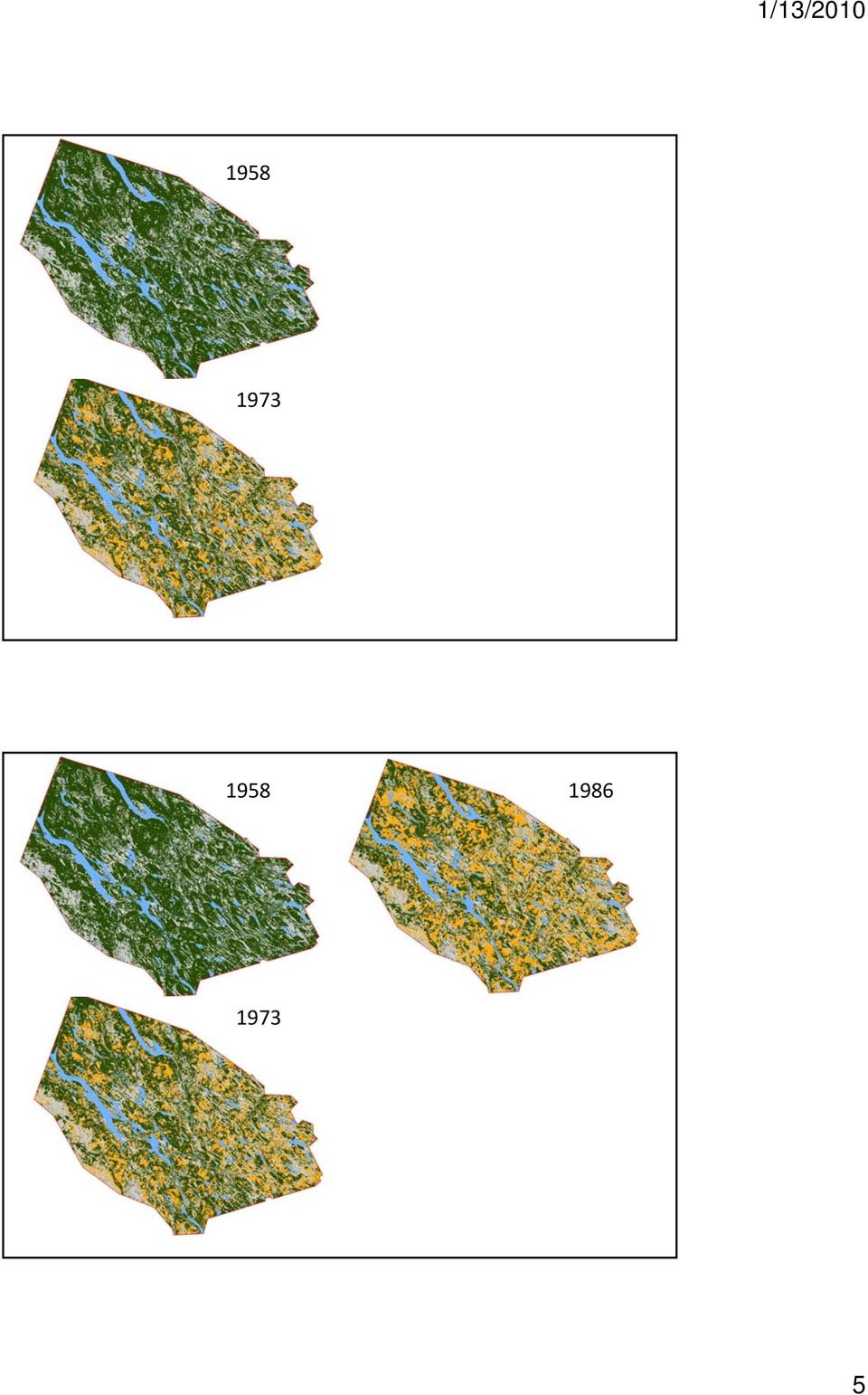
6 Vilhelmina Model Forest landscape lab Total area ha ( ha forest) Land ownership Private (family) owners: 36 % Private forest companies: 22 % State forest companies: 29 % Vilhelmina common: 10 % Church, Municipality: 3 % Land use ( ha) Forest management: 41 % Protected forest area: 21 % Non forested area: 38 % 6

7 Vilhelmina Model Forest landscape lab Total area ha ( ha forest) Vilhelmina Model Forest landscape lab Resolution is out of range Data is unknown and unused No implementation Societal benefit of the monitoring can be questioned ed Total area ha ( ha forest) Ongoing project Methodological / techological innovations Add / link to socio economic components Close cooperation with stakeholders Continuous test implementation From the ground up 7
 Ongoing project Methodological / techological innovations Add / link to socio economic components Close")
8 Monitoring approaches that allow spatial and temporal analyses of conditions and changes on landscape scale are necessary to add data into problem solving,, in particular under climate change and other global challenges 8

9 , in particular under climate change and other global challenges Protected areas in Sweden, in particular under climate change and other global challenges Protected areas in Sweden Biomes move northwards at a 5 10 km/year speed 9

10 , in particular under climate change and other global challenges Protected areas in Sweden Biomes move northwards at a 5 10 km/year speed Effect on alpine tree line in the Scandinavian Mountain range at 3 4 C increase NILS in the Scandinavian Mountain Range 144 inventory quadrats No plots Alpine tree line 50 0 Altitude (m) 10

11 Circular plots with different radius In total 356 variables, whereoff 269 in the field inventory Radius m 2 Variables 20 m 1257 Habitat type Tree cover Land use Disturbance 10 m 314 Shrub cover Field layer Bottom layer Site conditions 3.5 m 38.5 Tree regeneration Understorey trees 0.28 m 0.25 Field and bottom layer species Line intersect sampling y = A x π x m 2 x L A = area of the inventory area m = number of cross points L = total length of inventory lines 11

12 A posteriori classification Composing your own menu of variables ibl gives you the opportunity to address your specific problems and needs A posteriori classification Mixed / agricultural landscape Composing your own menu of variables ibl Mountainous / wetland landscape gives you the opportunity to address your specific problems and needs 12

13 Aerial IR photos allow for high resolution 87 variables (356) 67 for polygons 10 for line intercepts 10 for points General Habitat Categories NILS polygons Classifications into Biohab types 13

14 General Habitat Categories NILS polygons Classifications into Biohab types Communication NILS Flagships Communication hubs Test areas Landscape examples Light version data collections 14

15 For more information please visit nils.slu.se A program under development Initiation 1st rotation 2nd rotation 3rd rotation Environmental quality objectives Authorities / Researchers Landscape perspective Habitat focus Methodological adjustments Training of staff and inventory personnell Focus on field inventory Developing aerial photo interpretation Securing data quality Integration of field and aerial photo data Applications / deliverables Analyses / research Internationalization / collaboration 15

16 Environmental quality objectives Thriving wetlands Sustainable forests A varied agricultural landscape A magnificent mountain landscape A good built environment Reduced climate impact Zero eutrophication Flourishing lakes and streams A balanced marine environment, flourishing coastal areas and archipelagos A rich diversity of plant and animal life Examples of ongoing work Assessment and refinement of the environmental quality objectives Platform for other environmental monitoring and for research Inclusion of complementary inventories Continuous build up of approaches and capacity, including e.g: technology development (satellite images, laser scanning) inclusion of socio economic parameters into the monitoring system Climate change related applications Fragmentation and landscape index Historical data to expand the time series Web portal with data and analyses, free to use EU and other pan national approaches 16

Nature Values Screening Using Object-Based Image Analysis of Very High Resolution Remote Sensing Data
 Nature Values Screening Using Object-Based Image Analysis of Very High Resolution Remote Sensing Data Aleksi Räsänen*, Anssi Lensu, Markku Kuitunen Environmental Science and Technology Dept. of Biological
Application of airborne remote sensing for forest data collection
 Application of airborne remote sensing for forest data collection Gatis Erins, Foran Baltic The Foran SingleTree method based on a laser system developed by the Swedish Defense Research Agency is the first
ICP-Forests Level I grid net and its harmonization with the National Forest Inventory in Europe and in Spain
 CONVERGENCES AND COMPLEMENTARITIES OF FOREST INFORMATION SYSTEMS ICP-Forests Level I grid net and its harmonization with the National Forest Inventory in Europe and in Spain European scope Study of scenarios
Aquatic Biomes, Continued
 Aquatic Biomes, Continued Introduction Extent of Marine biomes Issues & challenges Factors influencing distribution Dynamics in time & space Depth Tour of marine biomes Issues (by biome) Freshwater biomes
Monitoring for Conservation Planning and Management. Environmental Evaluators Forum EPA Headquarters, USA June 14 15, 2007
 Monitoring for Conservation Planning and Management Environmental Evaluators Forum EPA Headquarters, USA June 14 15, 2007 Key Types of Decisions Prioritization (where Status to allocate scarce conservation
Creating Green Jobs within the Environment and Culture sector.
 Creating Green Jobs within the Environment and Culture sector. Matilda Skosana Environmental Programmes (ILO Definition): 1. DEFINITION OF GREEN JOB. Jobs are green when they help reduce negative environmental
SOKOINE UNIVERSITY OF AGRICULTURE
 SOKOINE UNIVERSITY OF AGRICULTURE FACULTY OF FORESTRY AND NATURE CONSERVATION CURRICULUM FOR MSc. (MNRSA) DEGREE PROGRAMME May 2009 MASTER OF SCIENCE IN MANAGEMENT OF NATURAL RESOURCES AND SUSTAINABLE
Review of the Availability and Accuracy. of Information about Forests: Phase I Report
 Review of the Availability and Accuracy of Information about Forests: Phase I Report Prepared by Minnesota Forest Resources Council Forest Resource Information Management Committee In partnership with
Communities, Biomes, and Ecosystems
 Communities, Biomes, and Ecosystems Before You Read Before you read the chapter, respond to these statements. 1. Write an A if you agree with the statement. 2. Write a D if you disagree with the statement.
MINNESOTA DEPARTMENT OF NATURAL RESOURCES. Division of Forestry
 MINNESOTA DEPARTMENT OF NATURAL RESOURCES Division of Forestry Other major programs: Private Forest Management Urban and Community Forestry Insect and Disease Management Urban and Community Forestry
Natural Resource-Based Planning*
 Natural Resource-Based Planning* Planning, when done well, is among the most powerful tools available to communities. A solid plan, based on good natural resource information, guides rational land-use
Remote Sensing and GIS Application In Change Detection Study In Urban Zone Using Multi Temporal Satellite
 Remote Sensing and GIS Application In Change Detection Study In Urban Zone Using Multi Temporal Satellite R.Manonmani, G.Mary Divya Suganya Institute of Remote Sensing, Anna University, Chennai 600 025
Vegetation Resources Inventory
 Vegetation Resources Inventory Guidelines for Preparing a Project Implementation Plan for Photo Interpretation Prepared by Ministry of Sustainable Resource Management Terrestrial Information Branch for
Biological Diversity and Tourism: Development of Guidelines for Sustainable Tourism in Vulnerable Ecosystems
 Biological Diversity and Tourism: Development of Guidelines for Sustainable Tourism in Vulnerable Ecosystems Secretariat of the Convention on Biological Diversity Foreword The rapid and often uncontrolled
Norwegian Forests. Policy and Resources
 Norwegian Forests Policy and Resources 21 Forestry in Norway Norway has long traditions in forestry and forest management, and for using wood in construction and as a source of energy. Sawn wood and round
Knowledge innovation project (KIP) on Accounting for natural capital and ecosystem services - scoping paper Public version 22 June 2015
 on Accounting for natural capital and ecosystem services - scoping paper Public version 22 June 2015") Knowledge innovation project (KIP) on Accounting for natural capital and ecosystem services - scoping paper Public version 22 June 2015 Abstract Establishing a sound method of natural capital accounting
Knowledge innovation project (KIP) on Accounting for natural capital and ecosystem services - scoping paper Public version 22 June 2015 Abstract Establishing a sound method of natural capital accounting
UPPER COLUMBIA BASIN NETWORK VEGETATION CLASSIFICATION AND MAPPING PROGRAM
 UPPER COLUMBIA BASIN NETWORK VEGETATION CLASSIFICATION AND MAPPING PROGRAM The Upper Columbia Basin Network (UCBN) includes nine parks with significant natural resources in the states of Idaho, Montana,
Understanding image scale and resolution
 Understanding image scale and resolution Ned Horning Version: 1.0 Creation Date: 2004-01-01 Revision Date: 2004-01-01 License: This document is licensed under a Creative Commons Attribution-Share Alike
 European Forest Data Centre Biosoil/Biodiversity Forest Type Map 2006 P. Kempeneers, JRC T. Durant F. Sedano, JRC L. Seebach, JRC J. San-Miguel-Ayanz, JRC EC -, IES Land Management and Natural Hazard Unit
CARBON BALANCE IN BIOMASS OF MAIN FOREST TREE SPECIES IN POLAND
 CARBON BALANCE IN BIOMASS OF MAIN FOREST TREE SPECIES IN POLAND PAWEŁ STRZELIŃSKI Department of Forest Management Poznan University of Life Science TOMASZ ZAWIŁA-NIEDŹWIECKI Forest Research Institute in
IMPLEMENTING ECOSYSTEM BASED INTEGRATED RESOURCE MANAGEMENT IN NOVA SCOTIA
 IMPLEMENTING ECOSYSTEM BASED INTEGRATED RESOURCE MANAGEMENT IN NOVA SCOTIA Bruce Stewart, Forest Ecologist, RPF, Peter Neily, Forest Ecologist, RPF Nova Scotia Department of Natural Resources, Truro, Nova
CONNECTIVITY CONSERVATION AND ECOLOGICAL RESTORATION ADVENTURES IN A GLOBAL BIODIVERSITY HOTSPOT
 CONNECTIVITY CONSERVATION AND ECOLOGICAL RESTORATION ADVENTURES IN A GLOBAL BIODIVERSITY HOTSPOT A presentation addressing Aichi Targets: 5 By 2020, the rate of loss of all natural habitats, including
Forest Inventory Strategic Plan
 February 2013 Ministry of Forests, Lands and Natural Resource Operations Forest Inventory Strategic Plan The forest inventory program outlined in this strategic plan will help the Ministry of Forests,
The Role of Spatial Data in EU Agricultural Policy Analysis
 The Role of Spatial Data in EU Agricultural Policy Analysis Wolfgang Britz Institute for Food and Resource Economics, University Bonn Geospatial Open Source Hosting of Agriculture, Resource and Environmental
State of Green Infrastructure in the Gauteng City-Region
 State of Green Infrastructure in the Gauteng City-Region Valuing Natural Capital Dialogue City of Johannesburg 26 th February 2014 Kerry Bobbins Researcher GCRO [email protected] Overview Structure
Using Aerial Photography to Measure Habitat Changes. Method
 Then and Now Using Aerial Photography to Measure Habitat Changes Method Subject Areas: environmental education, science, social studies Conceptual Framework Topic References: HIIIB, HIIIB1, HIIIB2, HIIIB3,
PROPERTY TAX RELIEF PROGRAMS
 PROPERTY TAX RELIEF PROGRAMS S.L. 2009-574 Studies Bill Revenue Laws Study Committee authorized to study issues relating to the effects on local units of government of enacted property tax relief programs
Barents Euro-Arctic Council (BEAC) Working Group on Environment Swedish Chairmanship 2010-2011 Work Programme Subgroup for Nature Protection
 Working Group on Environment Swedish Chairmanship 2010-2011 Work Programme Subgroup for Nature Protection") Miljödepartementet Barents Euro-Arctic Council (BEAC) Working Group on Environment Swedish Chairmanship 2010-2011 Adopted version Work Programme Subgroup for Nature Protection TABLE OF CONTENTS 1. Introduction
Miljödepartementet Barents Euro-Arctic Council (BEAC) Working Group on Environment Swedish Chairmanship 2010-2011 Adopted version Work Programme Subgroup for Nature Protection TABLE OF CONTENTS 1. Introduction
REPUBLIC OF TURKEY MINISTRY OF FORESTRY AND WATER AFFAIRS
 REPUBLIC OF TURKEY MINISTRY OF FORESTRY AND WATER AFFAIRS Turkey s position in the World Prof. Dr. Veysel EROĞLU Minister of Forestry and Water Affairs The Ministry of Forestry and Water Affairs, formerly
18 Month Summary of Progress
 18 Month Summary of Progress July 2014 1 Context Ecosystems provide humankind with a wide range of resources, goods and services. Yet the rate at which we consume and exploit these is increasing so rapidly
Broken Arrow Public Schools AP Environmental Science Objectives Revised 11-19-08
 1 st six weeks 1 Identify questions and problems that can be answered through scientific investigation. 2 Design and conduct scientific investigations to answer questions about the world by creating hypotheses;
World Data Center for Biodiversity and Ecology - ICSU WDC System. OAS/IABIN Protected Area Meeting January 23, 2007
 World Data Center for Biodiversity and Ecology - ICSU WDC System OAS/IABIN Protected Area Meeting January 23, 2007 WDCBE Partnerships ICSU World Data Center System USGS Host(s) - National Biological Information
Global Ecology and Wildlife Conservation
 Vaughan Centre for Lifelong Learning Part-Time Certificate of Higher Education in Global Ecology and Wildlife Conservation Delivered via Distance Learning FAQs What are the aims of the course? This course
EcoInformatics International Inc.
 1 von 10 03.08.2010 14:25 EcoInformatics International Inc. Home Services - solutions Projects Concepts Tools Links Contact EXPLORING BEAVER HABITAT AND DISTRIBUTION WITH GOOGLE EARTH: THE LONGEST BEAVER
Longboat Dr Noeleen Smyth. Pitcairn 24 21 41 S, 128 18 58 W. UK Overseas Territories and Crown Dependencies: 2011 Biodiversity snapshot 87
 Longboat Dr Noeleen Smyth Pitcairn 24 21 41 S, 128 18 58 W 13 UK Overseas Territories and Crown Dependencies: 2011 Biodiversity snapshot 87 Pitcairn Author: Michele Christian, Division Manager Natural
Green Infrastructure Case Study Template
 Green Infrastructure Case Study Template The aim of the exercise is to provide information on how the elements of the Green Infrastructure Strategy are implemented at national level and to provide case
Corralling the evidence about the value of Green Infrastructure. Martin Moss. Senior Advisor Green Infrastructure Operations England.
 Corralling the evidence about the value of Green Infrastructure Martin Moss. Senior Advisor Green Infrastructure Operations England. Flow of discussion. Part 1 - What do we mean by GI? Part 2 - What are
Objectives. Raster Data Discrete Classes. Spatial Information in Natural Resources FANR 3800. Review the raster data model
 Spatial Information in Natural Resources FANR 3800 Raster Analysis Objectives Review the raster data model Understand how raster analysis fundamentally differs from vector analysis Become familiar with
Revising the Nantahala and Pisgah Land Management Plan Preliminary Need to Change the Existing Land Management Plan
 Revising the Nantahala and Pisgah Land Management Plan Preliminary Need to Change the Existing Land Management Plan Throughout the Plan 1. There is a fundamental need for the revised plan to address how
Understanding Raster Data
 Introduction The following document is intended to provide a basic understanding of raster data. Raster data layers (commonly referred to as grids) are the essential data layers used in all tools developed
Since early 1994, The Northern Sacramento Valley Sustainable Landscapes
 Using Population Distribution Forecasts and GIS Technology to Assess Potential Hardwood Loss in the Northern Sacramento Valley 1 Charles W. Nelson 2 Mark Radabaugh 3 Abstract: Since its inception, The
7th Framework Programme Theme 6 Environment (including climate change)
") 7th Framework Programme Theme 6 Environment (including climate change) «Environnement» et «Énergie» Programme D. Deybe DG RTD Environment Directorate 1 Cooperation Collaborative Research Ten themes 1.
7th Framework Programme Theme 6 Environment (including climate change) «Environnement» et «Énergie» Programme D. Deybe DG RTD Environment Directorate 1 Cooperation Collaborative Research Ten themes 1.
Thank you to all of our 2015 sponsors: Media Partner
 Thank you to all of our 2015 sponsors: Media Partner Channel Naturalization: Planning and Implementation in Peel Region TRIECA March 25 & 26, 2015 Peel Region Channel Remediation Strategy An Urban Context
Landforms form an integral part
 Landform classification using GIS by Karsten Drescher, Terralogix Consulting, and Willem de Frey, Ekoinfo Refining existing landform classifications using ESRI s model builder. Landforms form an integral
TOWARDS A GLOBAL STRATEGY FOR THE ENVIRONMENTAL SUSTAINABILITY OF THE PROVINCE OF CUENCA (SPAIN)
") Boletín de la Towards Asociación a global de Geógrafos strategy for Españoles the environmental N.º 59-2012, sustainability págs. 435-440 of the province of Cuenca (Spain) I.S.S.N.: 0212-9426 TOWARDS A
Boletín de la Towards Asociación a global de Geógrafos strategy for Españoles the environmental N.º 59-2012, sustainability págs. 435-440 of the province of Cuenca (Spain) I.S.S.N.: 0212-9426 TOWARDS A
Ecosystem Services, Wetlands and Houston s Growth. Jim Lester
 Ecosystem Services, Wetlands and Houston s Growth Jim Lester Definitions (MEA 2005) Ecosystem: a dynamic complex of plant, animal, and microorganism communities and the nonliving environment interacting
Outline - needs of land cover - global land cover projects - GLI land cover product. legend. Cooperation with Global Mapping project
 Land Cover Mapping by GLI data Ryutaro Tateishi Center for Environmental Remote Sensing (CEReS) Chiba University E-mail: [email protected] Outline - needs of land cover - global land cover
A GIS PRIMER ON HOW TO ILLUSTRATE SPATIAL DATA AND INFORMATION GENERATED THROUGH NATIONAL FOREST INVENTORIES
 Forestry Department Food and Agriculture Organization of the United Nations A GIS PRIMER ON HOW TO ILLUSTRATE SPATIAL DATA AND INFORMATION GENERATED THROUGH NATIONAL FOREST INVENTORIES PREPARED BY CECILIA
Environmentally Significant Areas of Alberta. Volume 3. Prepared by: Sweetgrass Consultants Ltd. Calgary, AB. for:
 Environmentally Significant Areas of Alberta Volume 3 Prepared by: Calgary, AB for: Resource Data Division Alberta Environmental Protection Edmonton, Alberta March 1997 EXECUTIVE SUMMARY Large portions
Introduction to protection goals, ecosystem services and roles of risk management and risk assessment. Lorraine Maltby
 Introduction to protection goals, ecosystem services and roles of risk management and risk assessment. Lorraine Maltby Problem formulation Risk assessment Risk management Robust and efficient environmental
Conducting a Land Use Inventory
 Chapter 3 Conducting a Land Use Inventory Included in this chapter: Determining Current Land Use Conditions Preparing a Base Map Deciding on Land Use Categories Collecting Current Land Use Data Preparing
Ecological Restoration Strategies for Cattle Ranching Landscapes of the Azuero
 COURSE REPORT Ecological Restoration Strategies for Cattle Ranching Landscapes of the Azuero District of Pedasi, Province of Los Santos July 27-31, 2015 A field course organized by: The Environmental Leadership
THE ECOSYSTEM - Biomes
 Biomes The Ecosystem - Biomes Side 2 THE ECOSYSTEM - Biomes By the end of this topic you should be able to:- SYLLABUS STATEMENT ASSESSMENT STATEMENT CHECK NOTES 2.4 BIOMES 2.4.1 Define the term biome.
Colorado Natural Heritage Program
 CNHP s mission is to preserve the natural diversity of life by contributing the essential scientific foundation that leads to lasting conservation of Colorado's biological wealth. Colorado Natural Heritage
Chapter 3 Communities, Biomes, and Ecosystems
 Communities, Biomes, and Ecosystems Section 1: Community Ecology Section 2: Terrestrial Biomes Section 3: Aquatic Ecosystems Click on a lesson name to select. 3.1 Community Ecology Communities A biological
A pilot study - Monitoring of palsa mires in Sweden
 A pilot study - Monitoring of palsa mires in Sweden Laine Boresjö Bronge, Thomas Hedvall, Kjell Wester (Vattenfall Power Consultant) Susanne Backe (lst Norrbotten), Urban Gunnarsson (lst Dalarna), Johan
How To Manage Protected Areas
 ECHOES FROM BARILOCHE: Conclusions, Recommendations and Action Guidelines The Second Latin American Congress on National Parks and other Protected Areas aimed to asses, value and project the contribution
Appendix C. Municipal Planning and Site Restoration Considerations
 Appendix C Municipal Planning and Site Restoration Considerations 67 68 Appendix C - Municipal Planning and Site Restoration Considerations This appendix contains best practice standards for site planning
MAPPING MINNEAPOLIS URBAN TREE CANOPY. Why is Tree Canopy Important? Project Background. Mapping Minneapolis Urban Tree Canopy.
 MAPPING MINNEAPOLIS URBAN TREE CANOPY Why is Tree Canopy Important? Trees are an important component of urban environments. In addition to their aesthetic value, trees have significant economic and environmental
Madagascar: Makira REDD+
 project focus Madagascar: Makira REDD+ Madagascar is considered to be one of the top five biodiversity hotspots in the world due to more than 75% of all animal and plant species being endemic while less
Note on Draft Progress Report Template
 Note on Draft Progress Report Template The Draft Progress Report template is provided as a guide to applicants on possible reporting requirements for the Biodiversity Fund. This actual report will be provided
Origins and causes of river basin sediment degradation and available remediation and mitigation options. Feedback from the Riskbase workshop
 Origins and causes of river basin sediment degradation and available remediation and mitigation options Feedback from the Riskbase workshop Corinne Merly 1, Olivier Cerdan 1, Laurence Gourcy 1 Emmanuelle
The relationship of pastoralism to the SDGs. The land people livestock nexus
 1 The relationship of pastoralism to the SDGs. The land people livestock nexus Irene Hoffmann, FAO 16th Annual Mee-ng of the Inter-Agency Donor Group 18-20 November, GIZ, Berlin, Germany Global Land Cover-SHARE,
Improving global data on forest area & change Global Forest Remote Sensing Survey
 Improving global data on forest area & change Global Forest Remote Sensing Survey work by FAO and partners - Adam Gerrand, E. Lindquist, R. D Annunzio, M. Wilkie, FAO, - F. Achard et al. TREES team at
Wetland Mapping using High resolution Satellite Images in the Jaffna Peninsula
 Proceedings of Jaffna University International Research Conference (JUICE-2012), pp. 296-300, published: March 2014, Sri Lanka Wetland Mapping using High resolution Satellite Images in the Jaffna Peninsula
AP Environmental Science Syllabus
 Course Overview The following AP Environmental Science Syllabus will comply with all of the requirements and specifications provided by College Board aimed at preparing students for the AP exam given in
AQUATIC ECOSYSTEMS & BIOMES
 AQUATIC ECOSYSTEMS & BIOMES A) Name three general types of aquatic ecosystems and describe the salinity for each. Give an example for each. 1) 2) 3) B) MATCHING In the space provided, write the letter
LTER Portugal Network:
 Portugal LTER Portugal Network: implementation strategy and future perspectives Sociedade Portuguesa de Ecologia OUTLINE Portugal Brief history of LTER-Portugal Initiative Strategy for site selection Selected
Sustainability Brief: Water Quality and Watershed Integrity
 Sustainability Brief: and Watershed Integrity New Jersey depends on water resources for the health of our people, the strength of our economy, and the vitality of our ecosystems. The quality of our water
NATURAL RESOURCES DEGREES AND CERTIFICATES. Environmental Conservation A.S. Degree (formerly Natural Resources)
") Area: Science and Engineering Dean: Dr. Rina Roy Phone: (916) 484-8107 Counseling: (916) 484-8572 DEGREES AND CERTIFICATES Environmental Conservation A.S. Degree (formerly Natural Resources) Environmental
Area: Science and Engineering Dean: Dr. Rina Roy Phone: (916) 484-8107 Counseling: (916) 484-8572 DEGREES AND CERTIFICATES Environmental Conservation A.S. Degree (formerly Natural Resources) Environmental
WATER: ENVIRONMENTAL SCIENCE Syllabus
 WATER: ENVIRONMENTAL SCIENCE Syllabus Course Title Water: Environmental Science Course Description Central to all ecosystems, water is essential to life as we know it. It shapes our planet on every level,
Project Theory-Climate Change and Traditional Ecological Knowledge Adaption in the Klamath Basin
 Project Theory-Climate Change and Traditional Ecological Knowledge Adaption in the Klamath Basin Frank K. Lake Lead Science and TEK Mentor for project Education 1995 B.S. University of California, Davis.
Red-listed plants in semi-natural landscapes
 Red-listed plants in semi-natural landscapes Esgo Kuiper & Anders Bryn Norwegian Forest and Landscape Institute, PO Box 115, Raveien 9, NO-1431 Aas, Norway. Phone: +47 64948000, e-mail: [email protected]
CUBA CONFRONTING CLIMATE CHANGE
 CUBA CONFRONTING CLIMATE CHANGE CUBA: Main Characteristics Total population: 11.2 millions Length of the Island of Cuba: 1,200 Km. Maximum Width: 191 Km. Minimum Width: 31 Km. More than 4,000 islands and
MASS PROCESSING OF REMOTE SENSING DATA FOR ENVIRONMENTAL EVALUATION IN EUROPE
 MASS PROCESSING OF REMOTE SENSING DATA FOR ENVIRONMENTAL EVALUATION IN EUROPE Lic. Adrián González Applications Research Earth Science Conference 2014 29.07.2014 Earth Science San Conference Francisco
CRMS Website Training
 CRMS Website Training March 2013 http://www.lacoast.gov/crms Coastwide Reference Monitoring System - Wetlands CWPPRA Restoration Projects Congressionally funded in 1990 Multiple restoration techniques
News from the Inventory Section, Forest Analysis and Inventory Branch, Ministry of Forests Lands and Natural Resource Operations
 News from the Inventory Section, Forest Analysis and Inventory Branch, Ministry of Forests Lands and Natural Resource Operations January 20, 2012 Planning for 2012-13 Planning for 2012/13 is well underway
Mapping and Modelling the Impact of Land Use Planning and Management Practices on Urban and Peri-Urban Landscapes in the Greater Dublin Area
 Mapping and Modelling the Impact of Land Use Planning and Management Practices on Urban and Peri-Urban Landscapes in the Greater Dublin Area Dr. Martin Critchley Era-Maptec Ltd 36 Dame Street Dublin 2
A Developer s Guide: Watershed-Wise Development
 A Developer s Guide: Watershed-Wise Development Environmental Protection What is a watershed? It does not matter how far away you build from a creek, lake, or the ocean, you are in a watershed. Another
Chapter 5 Topographic Maps Bengt Rystedt, Sweden
 Chapter 5 Topographic Maps Bengt Rystedt, Sweden 5.1 Introduction A topographic map describes a place (topos is Greek for place). For a long time, they have been used for military purposes but are now
TERMS OF REFERENCE FOR THE RAPID EIA STUDY
 TERMS OF REFERENCE FOR THE RAPID EIA STUDY 1 SUMMARY OF EIA METHODOLOGY STEP I : SCOPING OF THE ASSESSMENT Own with prevailing regulatory setting and criteria Identification of Environmental Assessment
ENVIRONMENTAL SCIENCE CURRICULUM for CLASS IX to X
 ENVIRONMENTAL SCIENCE CURRICULUM for CLASS IX to X The Royal Society for Protection of Nature (RSPN) in collaboration with Department of Curriculum Research & Development (DCRD) of Ministry of Education