World Data Center for Biodiversity and Ecology - ICSU WDC System. OAS/IABIN Protected Area Meeting January 23, 2007
|
|
|
- Spencer Little
- 8 years ago
- Views:
Transcription
1 World Data Center for Biodiversity and Ecology - ICSU WDC System OAS/IABIN Protected Area Meeting January 23, 2007

2

3 WDCBE Partnerships ICSU World Data Center System USGS Host(s) - National Biological Information Infrastructure (NBII)/Biology - Geospatial Analysis and Monitoring (GAM)/Geography - Mapping Centers Rocky Mountain Mapping Center Global Data Tool Kit (GDT) Earth Resources Observation Systems Data Center (EROS) Rapid Landcover Mapping Tool (RLM)
 Earth Resources Observation Systems Data Center (EROS) Rapid Landcover Mapping")
4 WDCBE Partnerships GBIF (Specimens & Species distributions) - Value added data integration UNEP-WCMC (Protected Areas) - WDPA Redevelopment - Global value added databases - Tool development - IABIN (Regional data acquisition) - GAP/USGS format to IUCN data format BirdLife International (IBAs( IBAs) - Tools and global value added data sets - Data integration and analyses IABIN - tools and data input/integration/application

5 Other Joint GAM/NBII/WDCBE Activities GDT objective - web-enable enable data and allow users to easily and quickly access, update,, and apply public domain data for free Global data integration - biodiversity, ecosystems, and geophysical data Operationalization of RLCM Tool (NASA proposal) landcover change detection,ecosystem mapping, etc. (IABIN letter of support) GAP and conservation effectiveness analyses

6 Examples of Integrated Global Data (in a secure, large capacity, web-enabled enabled user oriented environment) Millennium Ecosystem Assessment (WDCBE is the formal archive) WDPA 2006 NGO Protected Areas Important Bird Area (IBA) Polygons Wilderness Areas Hotspots 2004 WWF Global 200 Terrestrial Ecosystems WWF Ecoregions Global Landcover 2000 Shaded Relief Major Rivers Major Lakes and Reservoirs Cities Landscan Global Populations Global Population Estimates 2005 Human Footprint (Human Influence Index) Etc.

7 Comparison between the PAD (national) vs. WDPA (global) Points vs. polygons Types of lands Management effectiveness

8 Protected Area polygons Open polygons Encroachment

9 Protected Area data

10 SCALE and Resolution PAD WDPA Types of management Levels of analysis PAD WDPA (US only) Polygons 344,185 10,103 Places 30,912 5,467 Granularity (resolution) of the data to support the various types of analyses
 of the data to support the various")
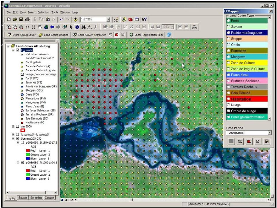
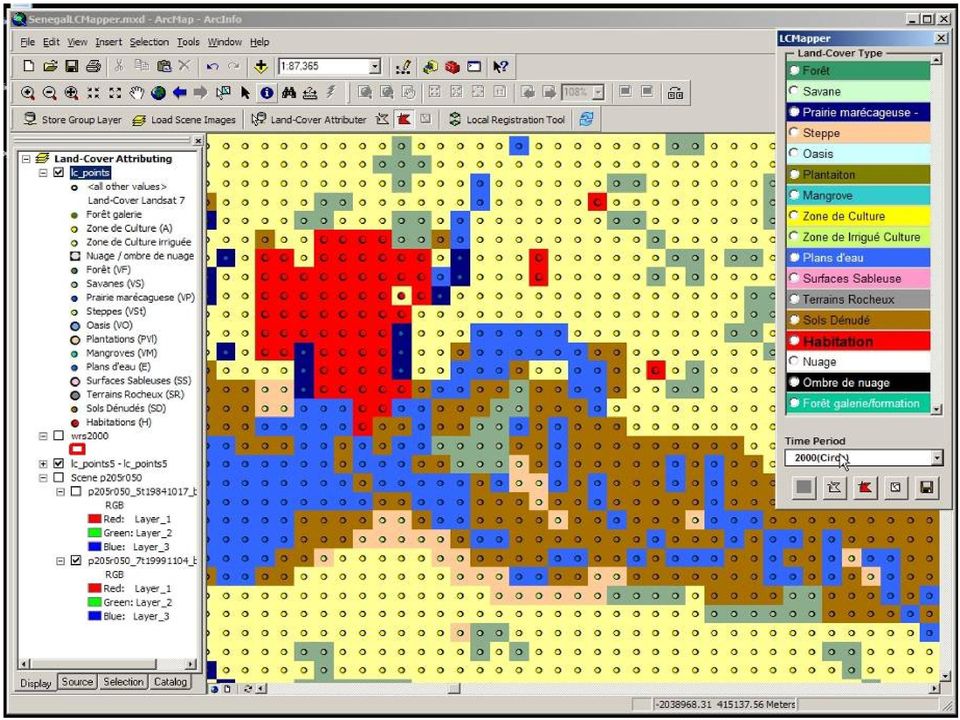
11 Rapid Landcover Mapping Tool (RLMT) USGS/EROS
")
12

13

14
15
16

17
18 Proposed IABIN Protected Area Workshop Goal: Pilot the ability of a regional organization (IABIN) and IABIN members to: Support protected area data acquisition and/or editing for global authorities (i.e., WCMC), View/process data with other integrated data sets, and Perform analyses and applications (i.e., CBD conservation measures). Location/Duration: : South/Central America for 3 days Participants: IABIN PATN and Secretariat sponsor/pilot participation IABIN National PA Coordinators (selected) data suppliers and active participation WDCBE sponsor/planning USGS/GAM/RMMC and NBII national level PA data set preparation, handouts, and course/tool instructors GEO sponsor and pilot participation WCMC pilot participation

19

20 Global Earth Observation System of Systems (GEOSS) Status Call for biodiversity and ecology task leadership/participation ( ) tasks are released USGS/WDCBE Interests/Involvement
 tasks are released USGS/WDCBE")
21 USGS/WDCBE/GAM/NBII Areas of Participation Staff secondment to GEOSS (Focus on Biodiversity and Ecology Societal Benefits) Task leadership and/or task group - Ecosystem Classification - Global Ecosystem Mapping - Tool Development - Global Biodiversity Observation Network/System (GBON)
22
23
24 GEOSS Task EC Lead and POC Roger Sayre, PhD U.S. Geological Survey Co-lead Alberto Yanosky, PhD Guyra Paraguay EC-06-02: Ecosystem Classification (from GEO Workplan) Establish an ad hoc Ecosystems Classification Task Force, covering terrestrial, freshwater, and ocean ecosystems, with a mandate to create a globally agreed, robust, and viable classification scheme for ecosystems. In parallel with the classification effort, develop, review, and initiate a mapping approach to spatially delineate the classified ecosystems.
25 Multi-tiered Ecosystems Classification Macro-scales: Land Cover, Ecoregions Meso-scales: Ecosystems Micro-scales: Vegetation
26 Ecosystems Mapping Model Step One Elevation Landforms Geology Ecosystem Footprints Step Two Ecosystems Classification Bioclimate Land Cover Labeled Ecosystems
27 South American Ecosystems Bioclimate
28 Standardized Ecosystems - Initiatives Global GEOSS Americas-wide IABIN US USGS
29 Level# Theme Terrestrial Freshwater Nearshore Neritic Oceanic 0 Domain separator Elevation > 0 (msl), latitude Elevation > 0 (msl), latitude Bathymetry 0 30m, latitude Bathymetry m, latitude Bathymetry > 200m, latitude 1 Macrobioclimate Climatic partitioning of Polar, Temperate, Tropical Climatic partitioning of Polar, Temperate, Tropical Climatic partitioning of Polar, Temperate, Tropical Climatic partitioning of Polar, Temperate, Tropical Climatic partitioning of Polar, Temperate, Tropical 2 Mesobioclimate Global land climate regions determined by climate data (biomes or plant functional types) Global land climate regions determined by climate data (tbd) Global marine climate regions defined by salinity Global marine climate regions defined by sea surface temperature, sea surface elevation, mixed layer depth, salinity Global marine climate regions defined by sea surface temperature, sea surface elevation, mixed layer depth, salinity 3 Biogeography separator Global phytogeography (Takhtajan) Global zoogeographic basins Global marine zoogeographic regions Global marine zoogeographic regions Global marine zoogeographic regions 4 Geochemical Topographic index of plant-available soil moisture; specialized substrates Ecological Drainage Units: climate/physiograp hy/substrate porosity Tidal mixing, wave energy, substrate texture Hydrochemical phenomena, seafloor landforms and substrate types 5 Biophysical structure Total biomass, vegetation structure, landscape juxtaposition Surface water character determining biotic structure (e.g., lakes, rivers, streams) e.g., Estuary, river plume, submarine groundwater discharge, reef; Biomass estimate by water column layer 6 Biotic composition Gradient from secondary vegetation to primary vegetation/undistur Macrohabitats; Fish/invertebrate communities Coastal macrohabitats Continental shelf macrohabitats Plankton communities
30 Mapping Approach Global Climate Data Global Geomorphology Data Level 1 Macroclimates Level 2 Mesoclimates Level 3 Abiotic Ecosystems
31 THANK YOU
Communities, Biomes, and Ecosystems
 Communities, Biomes, and Ecosystems Before You Read Before you read the chapter, respond to these statements. 1. Write an A if you agree with the statement. 2. Write a D if you disagree with the statement.
CIESIN Columbia University
 Conference on Climate Change and Official Statistics Oslo, Norway, 14-16 April 2008 The Role of Spatial Data Infrastructure in Integrating Climate Change Information with a Focus on Monitoring Observed
Chapter 3 Communities, Biomes, and Ecosystems
 Communities, Biomes, and Ecosystems Section 1: Community Ecology Section 2: Terrestrial Biomes Section 3: Aquatic Ecosystems Click on a lesson name to select. 3.1 Community Ecology Communities A biological
How do abiotic factors and physical processes impact life in the ocean?
 This website would like to remind you: Your browser (Apple Safari 7) is out of date. Update your browser for more security, comfort and the best experience on this site. Activitydevelop Ocean Abiotic Factors
THE ECOSYSTEM - Biomes
 Biomes The Ecosystem - Biomes Side 2 THE ECOSYSTEM - Biomes By the end of this topic you should be able to:- SYLLABUS STATEMENT ASSESSMENT STATEMENT CHECK NOTES 2.4 BIOMES 2.4.1 Define the term biome.
Monitoring for Conservation Planning and Management. Environmental Evaluators Forum EPA Headquarters, USA June 14 15, 2007
 Monitoring for Conservation Planning and Management Environmental Evaluators Forum EPA Headquarters, USA June 14 15, 2007 Key Types of Decisions Prioritization (where Status to allocate scarce conservation
Ecosystems. The two main ecosystem processes: Energy flow and Chemical cycling
 Ecosystems THE REALM OF ECOLOGY Biosphere An island ecosystem A desert spring ecosystem Biosphere Ecosystem Ecology: Interactions between the species in a given habitat and their physical environment.
Australian Antarctic Science Strategic Plan 2011-12 to 2020-21 Stream Implementation Plan November 2013
 Australian Antarctic Science Strategic Plan 2011-12 to 2020-21 Stream Implementation Plan November 2013 Stream 2.2 Stream goal Vulnerability and spatial protection To provide the scientific foundation
AQUATIC ECOSYSTEMS & BIOMES
 AQUATIC ECOSYSTEMS & BIOMES A) Name three general types of aquatic ecosystems and describe the salinity for each. Give an example for each. 1) 2) 3) B) MATCHING In the space provided, write the letter
A New Map of Global Ecological Land Units
 A New Map of Global Ecological Land Units Roger Sayre, Ph.D. Senior Scientist for Ecosystems U.S. Geological Survey rsayre@usgs.gov Dawn Wright, Ph.D. Chief Scientist dwright@esri.com Charlie Frye, M.A.
Biomes An Overview of Ecology Biomes Freshwater Biomes
 Biomes An Overview of Ecology Ecology is the scientific study of the interactions between organisms and their environments. Ecology can be divided into four increasingly comprehensive levels: Organismal
Approaches to biogeographic classification of the world s oceans. Marjo Vierros United Nations University Institute of Advanced Studies
 Approaches to biogeographic classification of the world s oceans Marjo Vierros United Nations University Institute of Advanced Studies This presentation will cover International policy developments of
Aquatic Biomes, Continued
 Aquatic Biomes, Continued Introduction Extent of Marine biomes Issues & challenges Factors influencing distribution Dynamics in time & space Depth Tour of marine biomes Issues (by biome) Freshwater biomes
A. Title of Proposed Project Development of a Protected Areas Database for Jamaica
 A. Title of Proposed Project Development of a Protected Areas Database for Jamaica B. Contact Information for Project Manager(s) Name: Sheries Simpson Address:10 Caledonia Avenue, Kingston 5. Country:
Restoration Planning and Development of a Restoration Bank
 Restoration Planning and Development of a Restoration Bank Black Creek Pioneer Village, South Theatre 8:30 a.m. to 3:30 p.m. Habitat Restoration and Environmental Monitoring Projects Section Restoration
Appendix B: Cost Estimates
 Appendix B: Estimates This appendix presents the estimated costs of the monitoring and supplemental research components presented in Section 3 of this document. A 20% quality assurance and quality control
The concepts developed in this standard include the following: Oceans cover about 70% of the surface of the Earth.
 Name Date Grade 5 SOL 5.6 Review Oceans Made by SOLpass - www.solpass.org solpass100@comcast.net Reproduction is permitted for SOLpass subscribers only. The concepts developed in this standard include
A framework for integrated wetland inventory, assessment and monitoring
 "Wetlands: water, life, and culture" 8th Meeting of the Conference of the Contracting Parties to the Convention on Wetlands (Ramsar, Iran, 1971) Valencia, Spain, 18-26 November 2002 Background Ramsar COP8
SEMESTER AT SEA COURSE SYLLABUS University of Virginia, Academic Sponsor
 Voyage: Fall 2015 Discipline: Biology Course Title: Introduction to Marine Biology Division: Lower Division Faculty Name: Dr Christine Dudgeon Credit Hours: 3; Contact Hours: 38 Pre-requisites: SEMESTER
Real-time Ocean Forecasting Needs at NCEP National Weather Service
 Real-time Ocean Forecasting Needs at NCEP National Weather Service D.B. Rao NCEP Environmental Modeling Center December, 2005 HYCOM Annual Meeting, Miami, FL COMMERCE ENVIRONMENT STATE/LOCAL PLANNING HEALTH
FRENCH ARCTIC INITIATIVE SCIENTIFIC PRIORITIES
 FRENCH ARCTIC INITIATIVE SCIENTIFIC PRIORITIES J.J. Pangrazi / Biosphoto J.J. Pangrazi / Biosphoto Conference audience Edouard Bard introductory lecture Dr. Denis-Didier Rousseau (CNRS Senior Research
Global environmental information Examples of EIS Data sets and applications
 METIER Graduate Training Course n 2 Montpellier - february 2007 Information Management in Environmental Sciences Global environmental information Examples of EIS Data sets and applications Global datasets
Introduction to protection goals, ecosystem services and roles of risk management and risk assessment. Lorraine Maltby
 Introduction to protection goals, ecosystem services and roles of risk management and risk assessment. Lorraine Maltby Problem formulation Risk assessment Risk management Robust and efficient environmental
The Integration of Hydrographic and Oceanographic Data in a Marine Geographic Information System U.S. Hydro 2015
 The Integration of Hydrographic and Oceanographic Data in a Marine Geographic Information System U.S. Hydro 2015 Karen Hart CARIS USA Oceanography and Hydrography Defined Oceanography: The branch of Earth
Ariana Sutton-Grier, Holly Bamford & Kateryna Wowk University of Maryland and National Oceanic and Atmospheric Administration
 Future of our coasts: Potential for natural and hybrid infrastructure Ariana Sutton-Grier, Holly Bamford & Kateryna Wowk University of Maryland and National Oceanic and Atmospheric Administration Green
2015 2016 Environmental Science Scope & Sequence
 2015 2016 Environmental Science Scope & Sequence The suggested time frames in this document are for a year long environmental science class with approximately 45 minute class periods. All of the material
The Next Generation Science Standards (NGSS) Correlation to. EarthComm, Second Edition. Project-Based Space and Earth System Science
 Correlation to. EarthComm, Second Edition. Project-Based Space and Earth System Science") The Next Generation Science Standards (NGSS) Achieve, Inc. on behalf of the twenty-six states and partners that collaborated on the NGSS Copyright 2013 Achieve, Inc. All rights reserved. Correlation to,
The Next Generation Science Standards (NGSS) Achieve, Inc. on behalf of the twenty-six states and partners that collaborated on the NGSS Copyright 2013 Achieve, Inc. All rights reserved. Correlation to,
National Inventory of Landscapes in Sweden
 Key messages Approaching the landscape perspective in monitoring experiences in the Swedish NILS program Johan Svensson, Future Forest Monitoring, 091112 Landscape level approaches are necessary to deal
Earth Systems. atmosphere, geosphere, biosphere, hydrosphere. Made by Liesl at homeschoolden.com
 Earth Systems atmosphere, geosphere, biosphere, hydrosphere You may make as many copies as you need for your homeschool or classroom. Feel free to link to the original post. Feel free to use the image
Vulnerability Assessment of New England Streams: Developing a Monitoring Network to Detect Climate Change Effects
 Vulnerability Assessment of New England Streams: Developing a Monitoring Network to Detect Climate Change Effects National Water Quality Monitoring Council 2012 Meeting Britta Bierwagen, National Center
GLACier-fed rivers, HYDRoECOlogy and climate change; NETwork of monitoring sites (GLAC-HYDRECO-NET).
.") Arctic Observing Summit 2013 Statement Glacier-fed rivers GLACier-fed rivers, HYDRoECOlogy and climate change; NETwork of monitoring sites (GLAC-HYDRECO-NET). Alexander Milner, School of Geography, Earth
Arctic Observing Summit 2013 Statement Glacier-fed rivers GLACier-fed rivers, HYDRoECOlogy and climate change; NETwork of monitoring sites (GLAC-HYDRECO-NET). Alexander Milner, School of Geography, Earth
Communities, Biomes, and Ecosystems
 Chapter Test A CHAPTER 3 Communities, Biomes, and Ecosystems Part A: Multiple Choice In the space at the left, write the letter of the term or phrase that best answers each question Part B: Matching 1
Web of Water. Teacher s Guide Webisode 1 Blue Ridge
 Web of Water Teacher s Guide Webisode 1 Blue Ridge Table of Contents About Blue Ridge.... 3 South Carolina Science Standards.. 4 Discussion Questions.. 10 Knowitall Resources....... 13 Credits..... 14
Broken Arrow Public Schools AP Environmental Science Objectives Revised 11-19-08
 1 st six weeks 1 Identify questions and problems that can be answered through scientific investigation. 2 Design and conduct scientific investigations to answer questions about the world by creating hypotheses;
Sustainability courses available at Florida State University
 Sustainability courses available at Florida State University (Please note be sure to consult the online course catalog each semester for course availability) Department Course Course Name Number BOT 3015
The Marine Protected Area Inventory
 The Marine Protected Area Inventory New pictures Jordan Gass, Hugo Selbie and Charlie Wahle ESRI Ocean Forum November 6, 2013 Outline What is the MPA Inventory? Purpose Data How it s used Future directions
GEOLOGY AND GEOMORPHOLOGY Level. bachelor Semester. winter ECTS 9
 GEOLOGY AND GEOMORPHOLOGY ECTS 9 The subject includes knowledge of the construction of the Earth and the natural processes occurring deeply inside and on the surface of the Earth. It contains characteristics
RUTHERFORD HIGH SCHOOL Rutherford, New Jersey COURSE OUTLINE ENVIRONMENTAL SCIENCE
 RUTHERFORD HIGH SCHOOL Rutherford, New Jersey COURSE OUTLINE ENVIRONMENTAL SCIENCE I. INTRODUCTION Environmental Science introduces students to a broad view of the biosphere and the physical parameters
RESPONSE FROM GBIF TO QUESTIONS FOR FURTHER CONSIDERATION
 RESPONSE FROM GBIF TO QUESTIONS FOR FURTHER CONSIDERATION A. Policy support tools and methodologies developed or used under the Convention and their adequacy, impact and obstacles to their uptake, as well
Environmental Science Overview
 Overview The standards establish the scientific inquiry skills and core content for all courses in DoDEA schools. The course of study provides students with a basic knowledge of the natural world that
The Global Earth Observation System of Systems (GEOSS) 10-Year Implementation Plan. (As adopted 16 February 2005)
 10-Year Implementation Plan. (As adopted 16 February 2005)") The Global Earth Observation System of Systems (GEOSS) 10-Year Implementation Plan (As adopted 16 February 2005) Preamble Understanding the Earth system its weather, climate, oceans, atmosphere, water,
The Global Earth Observation System of Systems (GEOSS) 10-Year Implementation Plan (As adopted 16 February 2005) Preamble Understanding the Earth system its weather, climate, oceans, atmosphere, water,
Climate, Vegetation, and Landforms
 Climate, Vegetation, and Landforms Definitions Climate is the average weather of a place over many years Geographers discuss five broad types of climates Moderate, dry, tropical, continental, polar Vegetation:
Greening REDD+ Challenges and opportunities for forest biodiversity conservation. Workshop summary
 Greening REDD+ Challenges and opportunities for forest biodiversity conservation Workshop summary D. Benick 1 *, S. Entenmann 2 *, T. Pistorius 1, C.B. Schmitt 2 1 Institute of Forest and Environmental
Long Term Challenges for Tidal Estuaries
 A view from a former tidal river manager expert with experience from 6 decades living at, with and from the Tidal River Elbe chairman of the European Interreg Project TIDE (Tidal River Development) Land
Data Quality Working Group
 Data Quality Working Group In order to get an overview of the issues that have been discussed so far, I have summarized them a little and added some links and references. The interesting discussion is
Environmental Science
 Environmental Science UNIT I: Introduction to Environmental Science The student will demonstrate the ability to use scientific skills necessary to identify and analyze environmental issues. a. Define environmental
Integrated Global Carbon Observations. Beverly Law Prof. Global Change Forest Science Science Chair, AmeriFlux Network Oregon State University
 Integrated Global Carbon Observations Beverly Law Prof. Global Change Forest Science Science Chair, AmeriFlux Network Oregon State University Total Anthropogenic Emissions 2008 Total Anthropogenic CO 2
COURSE OUTLINE. Geography 101 (C-ID Number: GEOG 110) Physical Geography (C-ID Title: Introduction to Physical Geography)
 Physical Geography (C-ID Title: Introduction to Physical Geography)") Degree Applicable Glendale Community College March 2013 COURSE OUTLINE Geography 101 (C-ID Number: GEOG 110) Physical Geography (C-ID Title: Introduction to Physical Geography) I. Catalog Statement Geography
Degree Applicable Glendale Community College March 2013 COURSE OUTLINE Geography 101 (C-ID Number: GEOG 110) Physical Geography (C-ID Title: Introduction to Physical Geography) I. Catalog Statement Geography
Monitoring the Critically Endangered Bird Species (White-shouldered Ibis) in Western Siem Pang Important Bird and Biodiversity Area (IBA)
 in Western Siem Pang Important Bird and Biodiversity Area (IBA)") Monitoring the Critically Endangered Bird Species (White-shouldered Ibis) in Western Siem Pang Important Bird and Biodiversity Area (IBA) Transboundary Biodiversity Landscapes (TBLs) Knowledge Meeting
Monitoring the Critically Endangered Bird Species (White-shouldered Ibis) in Western Siem Pang Important Bird and Biodiversity Area (IBA) Transboundary Biodiversity Landscapes (TBLs) Knowledge Meeting
COASTAL MONITORING & OBSERVATIONS LESSON PLAN Do You Have Change?
 Coastal Change Analysis Lesson Plan COASTAL MONITORING & OBSERVATIONS LESSON PLAN Do You Have Change? NOS Topic Coastal Monitoring and Observations Theme Coastal Change Analysis Links to Overview Essays
Resolution XII.13. Wetlands and disaster risk reduction
 12 th Meeting of the Conference of the Parties to the Convention on Wetlands (Ramsar, Iran, 1971) Punta del Este, Uruguay, 1-9 June 2015 Resolution XII.13 Wetlands and disaster risk reduction 1. RECALLING
Official Journal of the European Communities. (Acts whose publication is obligatory)
") 22.12.2000 L 327/1 I (Acts whose publication is obligatory) DIRECTIVE 2000/60/EC OF THE EUROPEAN PARLIAMT AND OF THE COUNCIL of 23 October 2000 establishing a framework for Community action in the field
22.12.2000 L 327/1 I (Acts whose publication is obligatory) DIRECTIVE 2000/60/EC OF THE EUROPEAN PARLIAMT AND OF THE COUNCIL of 23 October 2000 establishing a framework for Community action in the field
defined largely by regional variations in climate
 1 Physical Environment: Climate and Biomes EVPP 110 Lecture Instructor: Dr. Largen Fall 2003 2 Climate and Biomes Ecosystem concept physical and biological components of environment are considered as single,
SSS Soil System Sciences (#EGU15SSS) Orals Monday, 13 April
 Orals Monday, 13 April") SSS Soil System Sciences (#EGU15SSS) Orals Monday, 13 April MO1, 08:30 10:00 MO2, 10:30 12:00 MO3, 13:30 15:00 MO4, 15:30 17:00 SSS0.3, Deciphering time-dependent processes in soil and weathering profile
SSS Soil System Sciences (#EGU15SSS) Orals Monday, 13 April MO1, 08:30 10:00 MO2, 10:30 12:00 MO3, 13:30 15:00 MO4, 15:30 17:00 SSS0.3, Deciphering time-dependent processes in soil and weathering profile
CRMS Website Training
 CRMS Website Training March 2013 http://www.lacoast.gov/crms Coastwide Reference Monitoring System - Wetlands CWPPRA Restoration Projects Congressionally funded in 1990 Multiple restoration techniques
AP Environmental Science Syllabus
 Course Overview The following AP Environmental Science Syllabus will comply with all of the requirements and specifications provided by College Board aimed at preparing students for the AP exam given in
Data Integration Strategies
 Data Integration Strategies International Delta Roundtable November 2007 U.S. Department of the Interior U.S. Geological Survey USGS Data Integration Vision and Drivers USGS Science Strategy: Science in
HOW TO USE THE ES MAJOR TO CREATE YOUR OWN ENVIRONMENTAL EMPHASIS
 HOW TO USE THE ES MAJOR TO CREATE YOUR OWN ENVIRONMENTAL EMPHASIS 2011 Because of the interdisciplinary design of the Environmental Studies majors (B.A. and B.S.) students are afforded the opportunity
4. Which choice below lists the biomes in order from lowest precipitation amounts to highest precipitation amounts?
 Ecosystems and Biomes 1. All of the living organisms in a forest plus their environment is an example of A. a biome. B. a community. C. a population. D. an ecosystem. 2. Which of the following best describes
1. Michigan Geological History Presentation (Michigan Natural Resources)
") 1. Michigan Geological History Presentation (Michigan Natural Resources) The Michigan Geological History Presentation provides an overview of the approximately 3 billion years of Earth Processes that the
1. Michigan Geological History Presentation (Michigan Natural Resources) The Michigan Geological History Presentation provides an overview of the approximately 3 billion years of Earth Processes that the
Georgia Performance Standards Framework for Science Grade 6. Unit Organizer: Water in Earth s Processes. (Approximate Time: 5-6 Weeks)
") The following instructional plan is part of a GaDOE collection of Unit Frameworks, Performance Tasks, examples of Student Work, and Teacher Commentary. Many more GaDOE approved instructional plans are
The following instructional plan is part of a GaDOE collection of Unit Frameworks, Performance Tasks, examples of Student Work, and Teacher Commentary. Many more GaDOE approved instructional plans are
Multi-scale upscaling approaches of soil properties from soil monitoring data
 local scale landscape scale forest stand/ site level (management unit) Multi-scale upscaling approaches of soil properties from soil monitoring data sampling plot level Motivation: The Need for Regionalization
Newsletter January 2015
 C l i m a t e a n d L a n d U s e C h a n g e Understanding a changing world and how it impacts our natural resources, our livelihoods, and our communities Newsletter January 2015 New Map of Global Ecological
GRADE 6 SCIENCE. Demonstrate a respect for all forms of life and a growing appreciation for the beauty and diversity of God s world.
 GRADE 6 SCIENCE STRAND A Value and Attitudes Catholic Schools exist so that curriculum may be taught in the light of Gospel teachings. Teachers must reinforce Gospel truths and values so that students
Range Management Databases on the Web: Two Examples
 Range Management Databases on the Web: Two Examples George Ruyle, Chair, Rangeland & Forest Research Program, School of Renewable Natural Resources, Biological Sciences East 302, University of Arizona,
 Developing a Representative System of Marine Protected Areas in NSW 1 Developing a Representative System of Marine Protected Areas in NSW an Overview N O V E M B E R 2 0 0 1 New South Wales Developing
Nature Values Screening Using Object-Based Image Analysis of Very High Resolution Remote Sensing Data
 Nature Values Screening Using Object-Based Image Analysis of Very High Resolution Remote Sensing Data Aleksi Räsänen*, Anssi Lensu, Markku Kuitunen Environmental Science and Technology Dept. of Biological
Biology Keystone (PA Core) Quiz Ecology - (BIO.B.4.1.1 ) Ecological Organization, (BIO.B.4.1.2 ) Ecosystem Characteristics, (BIO.B.4.2.
 Quiz Ecology - (BIO.B.4.1.1 ) Ecological Organization, (BIO.B.4.1.2 ) Ecosystem Characteristics, (BIO.B.4.2.") Biology Keystone (PA Core) Quiz Ecology - (BIO.B.4.1.1 ) Ecological Organization, (BIO.B.4.1.2 ) Ecosystem Characteristics, (BIO.B.4.2.1 ) Energy Flow 1) Student Name: Teacher Name: Jared George Date:
Biology Keystone (PA Core) Quiz Ecology - (BIO.B.4.1.1 ) Ecological Organization, (BIO.B.4.1.2 ) Ecosystem Characteristics, (BIO.B.4.2.1 ) Energy Flow 1) Student Name: Teacher Name: Jared George Date:
Microclimate in the Outdoor Classroom
 Microclimate in the Outdoor Classroom 1. CONTRIBUTOR S NAME: TJ FONTAINE 2. NAME OF INQUIRY: MICROCLIMATE IN THE OUTDOOR CLASSROOM 3. GOALS AND OBJECTIVES: TEACH STUDENTS ABOUT THE SIMULARITIES AND DIFFERENCES
WATER AND DEVELOPMENT Vol. II - Types Of Environmental Models - R. A. Letcher and A. J. Jakeman
 TYPES OF ENVIRONMENTAL MODELS R. A. Letcher and A. J. Jakeman Centre for Resource and Environmental Studies, The Australian National University, Australia Keywords: environmental models, environmental
Coastwide Reference Monitoring System Wetlands (CRMS-Wetlands) Project Update
 Project Update") Coastwide Reference Monitoring System Wetlands (CRMS-Wetlands) Project Update Louisiana Department of Natural Resources Coastal Restoration Division U.S. Geological Survey National Wetlands Research Center
Coastwide Reference Monitoring System Wetlands (CRMS-Wetlands) Project Update Louisiana Department of Natural Resources Coastal Restoration Division U.S. Geological Survey National Wetlands Research Center
DATA FOR BIODIVERSITY SCENARIOS AND RELATED QUESTIONS IN WEST AFRICA
 Université NANGUI ABROGOUA West African Science Service Center on Climate Change and Adapted Land Use DATA FOR BIODIVERSITY SCENARIOS AND RELATED QUESTIONS IN WEST AFRICA Prof. Souleymane Konaté University
Biodiversity and Climate change: Policy Framework for Response and Vulnerability Assessment Report
 Biodiversity and Climate change: Policy Framework for Response and Vulnerability Assessment Report Vhalinavho Khavhagali Biodiversity Risk Management 2012 Biodiversity Planning Forum Skukuza, Kruger National
CE 110 Introduction to Environmental Engineering (3)
") Lecture Class Monday and Wednesday 3:30-4:45 pm KAP 163 Discussion Class Monday 5:00-5:50 pm KAP 163 Professor Office KAP 260 Phone 213-740-0592 Email Office Hours Class Webpage Teaching Assistant Office
Lecture Class Monday and Wednesday 3:30-4:45 pm KAP 163 Discussion Class Monday 5:00-5:50 pm KAP 163 Professor Office KAP 260 Phone 213-740-0592 Email Office Hours Class Webpage Teaching Assistant Office
Environmental Science Undergraduate programmes
 2015 Environmental Science Undergraduate programmes www.env.auckland.ac.nz Environmental Science at the University of Auckland Environmental Science is one of the core subjects offered by the School of
Coastal Drought and Water Supply in the Southeast
 Coastal Drought and Water Supply in the Southeast Jessica C. Whitehead, PhD. S.C. Sea Grant Consortium/N.C. Sea Grant 2010 Land Grant and Sea Grant National Water Conference 22 February 2010 Outline Coastal
Environmental Science & Management College of the Environment and Life Sciences (CELS) Revised April 2012
 Revised April 2012") Department: Natural Resources Science, 401-874-2495, http://www.nrs.uri.edu University College Advisor: Dr. Jose Amador, 401-874-2902; caimital@gmail.com Credits: 120 The Major: Environmental Science and
Department: Natural Resources Science, 401-874-2495, http://www.nrs.uri.edu University College Advisor: Dr. Jose Amador, 401-874-2902; caimital@gmail.com Credits: 120 The Major: Environmental Science and
Regularly offered Water Courses Please check the MSU website for current course offerings, prerequisites, and restrictions.
 AEC 829 The Economics of Environmental Resources Economic principles, theoretical models, and empirical methods related to environmental problems and policy interventions. Applications to air, land, water,
College of Science and Health ENVIRONMENTAL SCIENCE & GEOGRAPHY Course Outline
 College of Science and Health ENVIRONMENTAL SCIENCE & GEOGRAPHY Course Outline 1. TITLE OF COURSE AND COURSE NUMBER: General Geology ENV 115, 4 credits 2. DESCRIPTION OF THE COURSE: Includes the study
NOTE TO TEACHER: It is appropriate to introduce the mitochondria (where energy is made) as a major structure common to all cells.
 as a major structure common to all cells.") 5.2.1 Recall the cell as the smallest unit of life and identify its major structures (including cell membrane, cytoplasm, nucleus, and vacuole). Taxonomy level: 1.1 and 1.2-A Remember Factual Knowledge
5.2.1 Recall the cell as the smallest unit of life and identify its major structures (including cell membrane, cytoplasm, nucleus, and vacuole). Taxonomy level: 1.1 and 1.2-A Remember Factual Knowledge
Proposal for a Discovery-level WMO Metadata Standard
 WORLD METEOROLOGICAL ORGANIZATION MEETING OF EXPERT TEAM ON INTEGRATED DATA MANAGEMENT GENEVA, 17-20 SEPTEMBER 2001 ET-IDM/Doc. 3(1) (12.VI.2001) ITEM: 1.2 ENGLISH ONLY Proposal for a Discovery-level WMO
MODEL GUIDELINES FOR RIVER BASIN MANAGEMENT PLANNING IN ARMENIA
 MODEL GUIDELINES FOR RIVER BASIN MANAGEMENT PLANNING IN ARMENIA OCTOBER 2008 REPORT NO. 110 This publication was produced for review by the United States Agency for International Development. It was prepared
Mobilising Vegetation Plot Data: the National Vegetation Survey Databank. Susan Wiser April 2016 http://nvs.landcareresearch.co.nz
 Mobilising Vegetation Plot Data: the National Vegetation Survey Databank Susan Wiser April 2016 http://nvs.landcareresearch.co.nz Nationally Significant Databases and Collections http://natsigdc.landcareresearch.co.nz/natsigdc_list.html
Human Impacts on the World Ocean
 This website would like to remind you: Your browser (Safari 7) is out of date. Update your browser for more security, comfort and the best experience on this site. lesson Human Impacts on the World Ocean
STATE UNIVERSITY OF NEW YORK COLLEGE OF TECHNOLOGY CANTON, NEW YORK COURSE OUTLINE ESCI 101 - INTRODUCTION TO ENVIRONMENTAL SCIENCE
 STATE UNIVERSITY OF NEW YORK COLLEGE OF TECHNOLOGY CANTON, NEW YORK COURSE OUTLINE ESCI 101 - INTRODUCTION TO ENVIRONMENTAL SCIENCE Prepared By: Rajiv Narula, Ph.D. SCHOOL OF SCIENCE, HEALTH, AND CRIMINAL
Origins and causes of river basin sediment degradation and available remediation and mitigation options. Feedback from the Riskbase workshop
 Origins and causes of river basin sediment degradation and available remediation and mitigation options Feedback from the Riskbase workshop Corinne Merly 1, Olivier Cerdan 1, Laurence Gourcy 1 Emmanuelle
Aiding the Hydro-scheme development process. Web-links to useful information sources
 Aiding the Hydro-scheme development process. Web-links to useful information sources Web-pages are in bold. These pages aim at providing developers, land-owners, decision makers and advisors with a collation
Tourism and Biodiversity. Achieving Common Goals Towards Sustainability
 Tourism and Biodiversity Achieving Common Goals Towards Sustainability Tourism and Biodiversity Achieving Common Goals Towards Sustainability Copyright 2010 World Tourism Organization Calle Capitán Haya,
Protected Area Categories and Management Objectives
 Protected Area Categories and Management Objectives A protected area is defined as: An area of land and/or sea especially dedicated to the protection and maintenance of biological diversity, and of natural
www.basic.ncsu.edu/segap
 MANUAL FOR REVIEWING SE-GAP VERTEBRATE DATABASE/MODELS www.basic.ncsu.edu/segap TABLE OF CONTENTS TITLE PAGE IMPORTANT INFORMATION 1 OPENING THE DATABASE AND LOGGING IN 2 Opening the database, filling
Create Your Own Soil Profile Ac5vity
 Create Your Own Soil Profile Ac5vity Middle School: 5-8 Task Overview: Soil profile refers to layers of soil. A typical soil profile takes nearly 1,000 to 100,000 years to form. The formation of the soil
Ramsar COP8 DOC. 18 Information Paper English only
 "Wetlands: water, life, and culture" 8th Meeting of the Conference of the Contracting Parties to the Convention on Wetlands (Ramsar, Iran, 1971) Valencia, Spain, 18-26 November 2002 Ramsar COP8 DOC. 18
Landsat Monitoring our Earth s Condition for over 40 years
 Landsat Monitoring our Earth s Condition for over 40 years Thomas Cecere Land Remote Sensing Program USGS ISPRS:Earth Observing Data and Tools for Health Studies Arlington, VA August 28, 2013 U.S. Department
LIMNOLOGY, WATER QUALITY
 LIMNOLOGY, WATER QUALITY PA RANI ET E R S, AN D c 0 IV D IT I 0 N S AND ECOREGIONS Water Quality Parameters Nutrients are important parameters because phosphorous and nitrogen are major nutrients required
WORLD HERITAGE NOMINATION - IUCN TECHNICAL EVALUATION THE HIGH COAST (SWEDEN) ADDENDUM TO 1999 IUCN TECHNICAL EVALUATION
 ADDENDUM TO 1999 IUCN TECHNICAL EVALUATION") WORLD HERITAGE NOMINATION - IUCN TECHNICAL EVALUATION THE HIGH COAST (SWEDEN) ADDENDUM TO 1999 IUCN TECHNICAL EVALUATION 1. DOCUMENTATION The above nomination was reviewed by the 23 rd extraordinary session
WORLD HERITAGE NOMINATION - IUCN TECHNICAL EVALUATION THE HIGH COAST (SWEDEN) ADDENDUM TO 1999 IUCN TECHNICAL EVALUATION 1. DOCUMENTATION The above nomination was reviewed by the 23 rd extraordinary session
1.7.0 Floodplain Modification Criteria
 1.7.0 Floodplain Modification Criteria 1.7.1 Introduction These guidelines set out standards for evaluating and processing proposed modifications of the 100- year floodplain with the following objectives:
Belmont Forum Collaborative Research Action on Mountains as Sentinels of Change
 Belmont Forum Collaborative Research Action on Mountains as Sentinels of Change 1. Background and rationale Mountains exist in many regions of the world and are home to a significant fraction of the world
In this lesson, students will identify a local plant community and make a variety of
 MAKING COMMUNITY MEASUREMENTS: ABIOTIC FACTORS Grades 3 6 I. Introduction In this lesson, students will identify a local plant community and make a variety of measurements, preferably during two different
Multisensor Data Integration in O&G Business Lutz Petrat Hélène Lemonnier Michael Hall
 Multisensor Data in O&G Business Lutz Petrat Hélène Lemonnier Michael Hall ESA Oil and Gas Workshop 15/09/2010, Frascati, Italy Satellite Products and Services during a typical O&G project Project Life
Global Water Resources
 Global Water Resources Highlights from assessment activities over the past two decades, which are used to establish present and future water trends, reveal that: 1. Freshwater resources are unevenly distributed,