A pilot study - Monitoring of palsa mires in Sweden
|
|
|
- Violet Hudson
- 10 years ago
- Views:
Transcription
1 A pilot study - Monitoring of palsa mires in Sweden Laine Boresjö Bronge, Thomas Hedvall, Kjell Wester (Vattenfall Power Consultant) Susanne Backe (lst Norrbotten), Urban Gunnarsson (lst Dalarna), Johan Abenius (Naturvårdsverket)
, Johan Abenius")
2 Monitoring of palsa mires in Sweden Vattenfall Power Consultant AB The overall purpose is to develop an operational method based on very high-resolution satellite data in combination with detailed terrain data for monitoring of palsa mires in Sweden. Funding and project participants Funding from SEPA and Swedish National Space Board Laine Boresjö Bronge, Thomas Hedvall, Kjell Wester (Vattenfall Power Consultant) Susanne Backe (lst Norrbotten), Urban Gunnarsson (lst Dalarna), Johan Abenius (Naturvårdsverket)
 Susanne Backe (lst Norrbotten), Urban Gunnarsson (lst Dalarna), Johan Abenius")
3 Classification of the palsa mire vegetation based on the stages

4

5 Conceptual model - applied research palsa monitoring Literature review - old and recent work, often very detailed with many parameters, normally based on field work Aerial photographs historical and recent documentation of palsa mires New field work detailed documentation and calibration data for vegetation classification Laser scanning fingerprint of the current situation, base for monitoring, change analysis Satellite imagery documentation of current situation and classification of palsa vegetation To successfully put up a monitoring programme probably all these components are necessary, also to work interdisciplinary and near end users!

6 Indata Vattenfall Power Consultant AB Laserscanning (+/- 0,1 m; 0,5 m grid) July 2007, Taavavuoma August 2009, Taavavuoma + 9 st other palsa mire areas Satellite data IKONOS data, 2 July 2003, Taavavuoma QuickBird, 9 August 2009, Taavavuoma Kompsat data, 20 July 2009, Taavavuoma Kompsat data, 4 August 2009, Taavavuoma WorldView data August Digital aerial photographs Panchromatic 1963, Taavavuoma IR 1980, Taavavuoma Aerial photographs Field work, August 2009 and August 2010 Photos from helicopter Documentation (photos, field protocol, control/calibration areas)

7 Laserscanning Vattenfall Power Consultant AB Laserscanning from 700 m, 5,5 pt/m 2 (+/- 0,1 m; 0,5 m grid) July 2007, Taavavuoma August 2009, Taavavuoma + 9 st other palsa mire areas in Norrbotten Verify repeatability Documentation, presentation, analysis, monitoring changes, combine with vegetation mapping Zero -surface

8 Satellite data Vattenfall Power Consultant AB Satellite data IKONOS data, 2 July 2003, Taavavuoma QuickBird, 9 August 2009, Taavavuoma Kompsat data, 20 July 2009, Taavavuoma Kompsat data, 4 August 2009, Taavavuoma

9 Aerial photographs Vattenfall Power Consultant AB Digital aerial photographs Panchromatic 1963, Taavavuoma IR 1980, Taavavuoma

10 Field work Vattenfall Power Consultant AB Foto: Susanne Backe (lst Norrbotten)

11 Foto: Susanne Backe (lst Norrbotten)

12 Foto: Susanne Backe (lst Norrbotten)

13 Foto: Susanne Backe (lst Norrbotten)

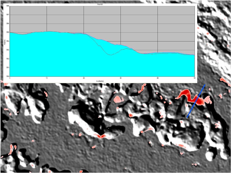
14 Laserscanning 2007 and 2009 Red areas = Differens > 20 cm in altitud between 2007 and 2009

15
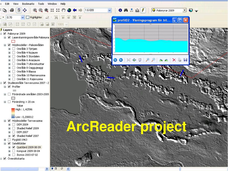
16 ArcReader project
17 Field work, augusti 2009 Vattenfall Power Consultant AB Foto: Susanne Backe (lst Norrbotten)

18 Conceptual model Vattenfall Power Consultant AB Literature review - old and recent work, often very detailed with many parameters, mainly based on field work. Aerial photographs historical and recent documentation of palsa mires Field work detailed documentation and calibration data for vegetation classification Laser scanning fingerprint of current situation, base for monitoring, change anaysis Satellite imagery documentation of current situation and classification of palsa vegetation To successfully put up a monitoring programme we think that you need all these components, also work interdisciplinary and near end users!

Spectral Response for DigitalGlobe Earth Imaging Instruments
 Spectral Response for DigitalGlobe Earth Imaging Instruments IKONOS The IKONOS satellite carries a high resolution panchromatic band covering most of the silicon response and four lower resolution spectral
Hydrographic Surveying using High Resolution Satellite Images
 Hydrographic Surveying using High Resolution Satellite Images Petra PHILIPSON and Frida ANDERSSON, Sweden Key words: remote sensing, high resolution, hydrographic survey, depth estimation. SUMMARY The
Information Contents of High Resolution Satellite Images
 Information Contents of High Resolution Satellite Images H. Topan, G. Büyüksalih Zonguldak Karelmas University K. Jacobsen University of Hannover, Germany Keywords: satellite images, mapping, resolution,
Radiological characterisation by means of 3D-laser modelling and positioning of measurements
 Radiological characterisation by means of 3D-laser modelling and positioning of measurements Robert Hedvall 1, Patrik Johansson 1, Peter Erixon 1, Fredrik Ekenborg 1, Feng Quanhong 2 and PA Andersson 3
National Inventory of Landscapes in Sweden
 Key messages Approaching the landscape perspective in monitoring experiences in the Swedish NILS program Johan Svensson, Future Forest Monitoring, 091112 Landscape level approaches are necessary to deal
Map World Forum Hyderabad, India Introduction: High and very high resolution space images: GIS Development
 Very high resolution satellite images - competition to aerial images Dr. Karsten Jacobsen Leibniz University Hannover, Germany [email protected] Introduction: Very high resolution images taken
High Resolution Digital Surface Models and Orthoimages for Telecom Network Planning
 Renouard, Lehmann 241 High Resolution Digital Surface Models and Orthoimages for Telecom Network Planning LAURENT RENOUARD, S ophia Antipolis FRANK LEHMANN, Berlin ABSTRACT DLR of Germany and ISTAR of
Files Used in this Tutorial
 Generate Point Clouds Tutorial This tutorial shows how to generate point clouds from IKONOS satellite stereo imagery. You will view the point clouds in the ENVI LiDAR Viewer. The estimated time to complete
Mapping Earth from Space Remote sensing and satellite images. Remote sensing developments from war
 Mapping Earth from Space Remote sensing and satellite images Geomatics includes all the following spatial technologies: a. Cartography "The art, science and technology of making maps" b. Geographic Information
Remote sensing is the collection of data without directly measuring the object it relies on the
 Chapter 8 Remote Sensing Chapter Overview Remote sensing is the collection of data without directly measuring the object it relies on the reflectance of natural or emitted electromagnetic radiation (EMR).
EVALUATION OF AIRBORNE LIDAR DIGITAL TERRAIN MAPPING FOR HIGHWAY CORRIDOR PLANNING AND DESIGN
 Waheed Uddin Director, Center for Advanced Infrastructure Technology, Carrier Hall 203 The University of Mississippi, University, MS 38677-1848, USA [email protected] KEY WORDS: Terrain, mapping, airborne,
UPDATING OBJECT FOR GIS DATABASE INFORMATION USING HIGH RESOLUTION SATELLITE IMAGES: A CASE STUDY ZONGULDAK
 UPDATING OBJECT FOR GIS DATABASE INFORMATION USING HIGH RESOLUTION SATELLITE IMAGES: A CASE STUDY ZONGULDAK M. Alkan 1, *, D. Arca 1, Ç. Bayik 1, A.M. Marangoz 1 1 Zonguldak Karaelmas University, Engineering
How To Make An Orthophoto
 ISSUE 2 SEPTEMBER 2014 TSA Endorsed by: CLIENT GUIDE TO DIGITAL ORTHO- PHOTOGRAPHY The Survey Association s Client Guides are primarily aimed at other professionals such as engineers, architects, planners
Resolutions of Remote Sensing
 Resolutions of Remote Sensing 1. Spatial (what area and how detailed) 2. Spectral (what colors bands) 3. Temporal (time of day/season/year) 4. Radiometric (color depth) Spatial Resolution describes how
MULTIPURPOSE USE OF ORTHOPHOTO MAPS FORMING BASIS TO DIGITAL CADASTRE DATA AND THE VISION OF THE GENERAL DIRECTORATE OF LAND REGISTRY AND CADASTRE
 MULTIPURPOSE USE OF ORTHOPHOTO MAPS FORMING BASIS TO DIGITAL CADASTRE DATA AND THE VISION OF THE GENERAL DIRECTORATE OF LAND REGISTRY AND CADASTRE E.ÖZER, H.TUNA, F.Ç.ACAR, B.ERKEK, S.BAKICI General Directorate
'Developments and benefits of hydrographic surveying using multispectral imagery in the coastal zone
 Abstract With the recent launch of enhanced high-resolution commercial satellites, available imagery has improved from four-bands to eight-band multispectral. Simultaneously developments in remote sensing
Recent advances in Satellite Imagery for Oil and Gas Exploration and Production. DESK AND DERRICK APRIL 2016 PRESENTED BY GARY CREWS---RETIRED
 Recent advances in Satellite Imagery for Oil and Gas Exploration and Production. DESK AND DERRICK APRIL 2016 PRESENTED BY GARY CREWS---RETIRED Agenda Brief review of state of the applications in 2010 Basics
Nature Values Screening Using Object-Based Image Analysis of Very High Resolution Remote Sensing Data
 Nature Values Screening Using Object-Based Image Analysis of Very High Resolution Remote Sensing Data Aleksi Räsänen*, Anssi Lensu, Markku Kuitunen Environmental Science and Technology Dept. of Biological
Understanding Raster Data
 Introduction The following document is intended to provide a basic understanding of raster data. Raster data layers (commonly referred to as grids) are the essential data layers used in all tools developed
Research On The Classification Of High Resolution Image Based On Object-oriented And Class Rule
 Research On The Classification Of High Resolution Image Based On Object-oriented And Class Rule Li Chaokui a,b, Fang Wen a,b, Dong Xiaojiao a,b a National-Local Joint Engineering Laboratory of Geo-Spatial
5.1. Spheres - A View from Above: Selected Google Earth Imagery. John R. English NARCAP Research Associate
 narcap Project Sphere 5.1 Page 1 J. R. English 5.1 Spheres - A View from Above: Selected Google Earth Imagery John R. English NARCAP Research Associate January 2009 Copyright Introduction This paper presents
Remote Sensing in Natural Resources Mapping
 Remote Sensing in Natural Resources Mapping NRS 516, Spring 2016 Overview of Remote Sensing in Natural Resources Mapping What is remote sensing? Why remote sensing? Examples of remote sensing in natural
Adaptation of High Resolution Ikonos Images to Googleearth for Zonguldak Test Field
 Adaptation of High Resolution Ikonos Images to Googleearth for Zonguldak Test Field Umut G. SEFERCIK, Murat ORUC and Mehmet ALKAN, Turkey Key words: Image Processing, Information Content, Image Understanding,
Methane to Markets Oil and Natural Gas Technology Transfer Workshop
 Methane to Markets Oil and Natural Gas Technology Transfer Workshop Airborne Differential Absorption Lidar (DIAL) Detection and Measurement of Fugitive Emissions Steven Stearns ANGEL Service ITT Space
Using Geographic Information Systems to Increment the Knowledge of Cultural Landscapes
 Congresso Nazionale AICA 2011 Torino, 15 16 17 Novembre 2011 Using Geographic Information Systems to Increment the Knowledge of Cultural Landscapes Amelia C. Sparavigna, Roberto Marazzato Politecnico di
WHAT IS GIS - AN INRODUCTION
 WHAT IS GIS - AN INRODUCTION GIS DEFINITION GIS is an acronym for: Geographic Information Systems Geographic This term is used because GIS tend to deal primarily with geographic or spatial features. Information
Coastal Engineering Indices to Inform Regional Management
 Coastal Engineering Indices to Inform Regional Management Lauren Dunkin FSBPA 14 February 2013 Outline Program overview Standard products Coastal Engineering Index Conclusion and future work US Army Corps
Using Optech LMS to Calibrate Survey Data Without Ground Control Points
 Challenge An Optech client conducted an airborne lidar survey over a sparsely developed river valley. The data processors were finding that the data acquired in this survey was particularly difficult to
The YellowScan system: A test on the oppida of Nages/Roque de Viou (Languedoc, France) Tristan Allouis, PhD Research and Development, L'Avion Jaune
 Tristan Allouis, PhD Research and Development, L'Avion Jaune") The YellowScan system: A test on the oppida of Nages/Roque de Viou (Languedoc, France) Tristan Allouis, PhD Research and Development, L'Avion Jaune L'Avion Jaune : Earth observation data provider UAVs
The YellowScan system: A test on the oppida of Nages/Roque de Viou (Languedoc, France) Tristan Allouis, PhD Research and Development, L'Avion Jaune L'Avion Jaune : Earth observation data provider UAVs
EcoInformatics International Inc.
 1 von 10 03.08.2010 14:25 EcoInformatics International Inc. Home Services - solutions Projects Concepts Tools Links Contact EXPLORING BEAVER HABITAT AND DISTRIBUTION WITH GOOGLE EARTH: THE LONGEST BEAVER
HIGH SPATIAL RESOLUTION IMAGES - A NEW WAY TO BRAZILIAN'S CARTOGRAPHIC MAPPING
 CO-192 HIGH SPATIAL RESOLUTION IMAGES - A NEW WAY TO BRAZILIAN'S CARTOGRAPHIC MAPPING BIAS E., BAPTISTA G., BRITES R., RIBEIRO R. Universicidade de Brasíia, BRASILIA, BRAZIL ABSTRACT This paper aims, from
STATE OF NEVADA Department of Administration Division of Human Resource Management CLASS SPECIFICATION
 STATE OF NEVADA Department of Administration Division of Human Resource Management CLASS SPECIFICATION TITLE PHOTOGRAMMETRIST/CARTOGRAPHER V 39 6.102 PHOTOGRAMMETRIST/CARTOGRAPHER II 33 6.110 PHOTOGRAMMETRIST/CARTOGRAPHER
Active and Passive Microwave Remote Sensing
 Active and Passive Microwave Remote Sensing Passive remote sensing system record EMR that was reflected (e.g., blue, green, red, and near IR) or emitted (e.g., thermal IR) from the surface of the Earth.
CARBON BALANCE IN BIOMASS OF MAIN FOREST TREE SPECIES IN POLAND
 CARBON BALANCE IN BIOMASS OF MAIN FOREST TREE SPECIES IN POLAND PAWEŁ STRZELIŃSKI Department of Forest Management Poznan University of Life Science TOMASZ ZAWIŁA-NIEDŹWIECKI Forest Research Institute in
A System of Shadow Detection and Shadow Removal for High Resolution Remote Sensing Images
 A System of Shadow Detection and Shadow Removal for High Resolution Remote Sensing Images G.Gayathri PG student, Department of Computer Science and Engineering, Parisutham Institute of Technology and Science,
High Resolution RF Analysis: The Benefits of Lidar Terrain & Clutter Datasets
 0 High Resolution RF Analysis: The Benefits of Lidar Terrain & Clutter Datasets January 15, 2014 Martin Rais 1 High Resolution Terrain & Clutter Datasets: Why Lidar? There are myriad methods, techniques
Methods for Monitoring Forest and Land Cover Changes and Unchanged Areas from Long Time Series
 Methods for Monitoring Forest and Land Cover Changes and Unchanged Areas from Long Time Series Project using historical satellite data from SACCESS (Swedish National Satellite Data Archive) for developing
ONE METER AND BELOW HIGH RESOLUTION SATELLITES IN PRODUCTION
 ONE METER AND BELOW HIGH RESOLUTION SATELLITES IN PRODUCTION A. Demirel, I. Bayir Inta Space Turk (Space Imaging Eurasia), Haymana Yolu 12.Km 06830 Golbasi Ankara, TURKEY ([email protected], [email protected])
Multiscale Object-Based Classification of Satellite Images Merging Multispectral Information with Panchromatic Textural Features
 Remote Sensing and Geoinformation Lena Halounová, Editor not only for Scientific Cooperation EARSeL, 2011 Multiscale Object-Based Classification of Satellite Images Merging Multispectral Information with
TUTORIAL Extraction of Geospatial Information from High Spatial Resolution Optical Satellite Sensors
 TUTORIAL Extraction of Geospatial Information from High Spatial Resolution Optical Satellite Sensors E. Baltsavias 1,L. Zhang 2, D. Holland 3, P.K. Srivastava 4, B. Gopala Krishna 4, T.P. Srinivasan 4
Nationwide forest estimates in Sweden using satellite data and airborne LiDAR. (Or: going from 2 D to 3D)
") Nationwide forest estimates in Sweden using satellite data and airborne LiDAR (Or: going from 2 D to 3D) Håkan Olsson Mats Nilsson, Johan Fransson, Henrik Persson and Mikael Egberth (SLU) Umeå Svante Larsson
Nationwide forest estimates in Sweden using satellite data and airborne LiDAR (Or: going from 2 D to 3D) Håkan Olsson Mats Nilsson, Johan Fransson, Henrik Persson and Mikael Egberth (SLU) Umeå Svante Larsson
APPLICATION OF MULTITEMPORAL LANDSAT DATA TO MAP AND MONITOR LAND COVER AND LAND USE CHANGE IN THE CHESAPEAKE BAY WATERSHED
 APPLICATION OF MULTITEMPORAL LANDSAT DATA TO MAP AND MONITOR LAND COVER AND LAND USE CHANGE IN THE CHESAPEAKE BAY WATERSHED S. J. GOETZ Woods Hole Research Center Woods Hole, Massachusetts 054-096 USA
A remote sensing instrument collects information about an object or phenomenon within the
 Satellite Remote Sensing GE 4150- Natural Hazards Some slides taken from Ann Maclean: Introduction to Digital Image Processing Remote Sensing the art, science, and technology of obtaining reliable information
From Ideas to Innovation
 From Ideas to Innovation Selected Applications from the CRC Research Lab in Advanced Geomatics Image Processing Dr. Yun Zhang Canada Research Chair Laboratory in Advanced Geomatics Image Processing (CRC-AGIP
Airborne LIDAR Digital Terrain Mapping for Transportation Infrastructure Asset Management
 Uddin and Al-Turk 1 Airborne LIDAR Digital Terrain Mapping for Transportation Infrastructure Asset Management Waheed Uddin The University of Mississippi Associate Professor of Civil Engineering Director,
RESOLUTION MERGE OF 1:35.000 SCALE AERIAL PHOTOGRAPHS WITH LANDSAT 7 ETM IMAGERY
 RESOLUTION MERGE OF 1:35.000 SCALE AERIAL PHOTOGRAPHS WITH LANDSAT 7 ETM IMAGERY M. Erdogan, H.H. Maras, A. Yilmaz, Ö.T. Özerbil General Command of Mapping 06100 Dikimevi, Ankara, TURKEY - (mustafa.erdogan;
Chapter 5 Topographic Maps Bengt Rystedt, Sweden
 Chapter 5 Topographic Maps Bengt Rystedt, Sweden 5.1 Introduction A topographic map describes a place (topos is Greek for place). For a long time, they have been used for military purposes but are now
Pima Regional Remote Sensing Program
 Pima Regional Remote Sensing Program Activity Orthophoto GIS Mapping and Analysis Implementing Agency Pima Association of Governments (Tucson, Arizona area Metropolitan Planning Organization) Summary Through
Remote Sensing Satellite Information Sheets Geophysical Institute University of Alaska Fairbanks
 Remote Sensing Satellite Information Sheets Geophysical Institute University of Alaska Fairbanks ASTER Advanced Spaceborne Thermal Emission and Reflection Radiometer AVHRR Advanced Very High Resolution
THE OBJECT-BASED APPROACH FOR URBAN LAND USE CLASSIFICATION USING HIGH RESOLUTION SATELLITE IMAGERY (A CASE STUDY ZANJAN CITY)
") Proceedings of the 4th GEOBIA, May 7-9, 2012 - Rio de Janeiro - Brazil. p.678 THE OBJECT-BASED APPROACH FOR URBAN LAND USE CLASSIFICATION USING HIGH RESOLUTION SATELLITE IMAGERY (A CASE STUDY ZANJAN CITY)
Proceedings of the 4th GEOBIA, May 7-9, 2012 - Rio de Janeiro - Brazil. p.678 THE OBJECT-BASED APPROACH FOR URBAN LAND USE CLASSIFICATION USING HIGH RESOLUTION SATELLITE IMAGERY (A CASE STUDY ZANJAN CITY)
Core Imagery Product Guide. v. 2.0
 Core Imagery Product Guide v. 2.0 Disclaimer & Copyright Copyright 2014 DigitalGlobe, Inc. All rights reserved. The DigitalGlobe s Core Imagery Product Guide is purposely designed as a general guideline
MAPPING MINNEAPOLIS URBAN TREE CANOPY. Why is Tree Canopy Important? Project Background. Mapping Minneapolis Urban Tree Canopy.
 MAPPING MINNEAPOLIS URBAN TREE CANOPY Why is Tree Canopy Important? Trees are an important component of urban environments. In addition to their aesthetic value, trees have significant economic and environmental
Digital Remote Sensing Data Processing Digital Remote Sensing Data Processing and Analysis: An Introduction and Analysis: An Introduction
 Digital Remote Sensing Data Processing Digital Remote Sensing Data Processing and Analysis: An Introduction and Analysis: An Introduction Content Remote sensing data Spatial, spectral, radiometric and
HIGH RESOLUTION REMOTE SENSING AND GIS FOR URBAN ANALYSIS: CASE STUDY BURITIS DISTRICT, BELO HORIZONTE, MINAS GERAIS
 HIGH RESOLUTION REMOTE SENSING AND GIS FOR URBAN ANALYSIS: CASE STUDY BURITIS DISTRICT, BELO HORIZONTE, MINAS GERAIS Hermann Johann Heinrich Kux Senior Researcher III INPE, Remote Sensing Division DAAD
Contributions of the geospatial fields to monitoring sustainability of urban environments John Trinder. School of Civil and Environmental Engineering
 Contributions of the geospatial fields to monitoring sustainability of urban environments John Trinder School of Civil and Environmental Engineering 2 IMPACT OF HUMAN DEVELOPMENT Humans are modifying the
Preface. Ko Ko Lwin Division of Spatial Information Science University of Tsukuba 2008
 1 Preface Remote Sensing data is one of the primary data sources in GIS analysis. The objective of this material is to provide fundamentals of Remote Sensing technology and its applications in Geographical
Presentation of the BOFORS 3P and System Concept. BOFORS 40/57 mm 3P. - Remotely Controlled Turret System. - Bushmaster IV integration
 Presentation of the BOFORS 3P and System Concept 98 40/48B SLPPRJ 90 LK 17398001 - BOFORS 40/57 mm 3P - Remotely Controlled Turret System - Bushmaster IV integration Mr Michael Borén Product Director,
PROS AND CONS OF THE ORIENTATION OF VERY HIGH RESOLUTION OPTICAL SPACE IMAGES
 PROS AND CONS OF THE ORIENTATION OF VERY HIGH RESOLUTION OPTICAL SPACE IMAGES K. Jacobsen University of Hannover [email protected] Commission I, WG I/5 KEY WORDS: Geometric Modelling, Orientation,
Advanced Image Management using the Mosaic Dataset
 Esri International User Conference San Diego, California Technical Workshops July 25, 2012 Advanced Image Management using the Mosaic Dataset Vinay Viswambharan, Mike Muller Agenda ArcGIS Image Management
FUSION OF INSAR HIGH RESOLUTION IMAGERY AND LOW RESOLUTION OPTICAL IMAGERY
 FUSION OF INSAR HIGH RESOLUTION IMAGERY AND LOW RESOLUTION OPTICAL IMAGERY J. Bryan Mercer a*, Dan Edwards a, Gang Hong b, Joel Maduck a, Yun Zhang b a Intermap Technologies Corp., Calgary, Canada, [email protected]
RESULTS OF THE PROJECT MONITORING LAND-USE DYNAMICS FOR ISTANBUL 1945 2000
 RESULTS OF THE PROJECT MONITORING LAND-USE DYNAMICS FOR ISTANBUL 1945 2000 Gerhard KEMPER*, Orhan ALTAN**, Murat CELIKOYAN **, Carlo LAVALLE***, Luca DEMICHELI*** *GGS Speyer, Geotechnik, Geoinformatik,
Technologies Enabling the Evolution of a Smart City. Brad Schmidt, Intergraph Canada
 Technologies Enabling the Evolution of a Smart City Brad Schmidt, Intergraph Canada AGENDA The Smart City Key Challenges Facing Cities Technology Challenges Smart Sensor Integration Smart Apps Smart Data
Laserscanning experiments and experiences in Norway. Håvard Tveite NOF & UMB Jan R. Lien UiB
 Laserscanning experiments and experiences in Norway Håvard Tveite NOF & UMB Jan R. Lien UiB 1 Experiences WOC 2010, Trondheim Special purpose laser scanning by Terratec Contours only 1.25 meter contour
REGIONAL CENTRE FOR TRAINING IN AEROSPACE SURVEYS (RECTAS) MASTER IN GEOINFORMATION PRODUCTION AND MANAGEMENT
 MASTER IN GEOINFORMATION PRODUCTION AND MANAGEMENT") REGIONAL CENTRE FOR TRAINING IN AEROSPACE SURVEYS (RECTAS) MASTER IN GEOINFORMATION PRODUCTION AND MANAGEMENT PROGRAMME DESCRIPTION October 2014 1. The programme The academic programme shall be referred
REGIONAL CENTRE FOR TRAINING IN AEROSPACE SURVEYS (RECTAS) MASTER IN GEOINFORMATION PRODUCTION AND MANAGEMENT PROGRAMME DESCRIPTION October 2014 1. The programme The academic programme shall be referred
Introduction to Imagery and Raster Data in ArcGIS
 Esri International User Conference San Diego, California Technical Workshops July 25, 2012 Introduction to Imagery and Raster Data in ArcGIS Simon Woo slides Cody Benkelman - demos Overview of Presentation
Image Analysis CHAPTER 16 16.1 ANALYSIS PROCEDURES
 CHAPTER 16 Image Analysis 16.1 ANALYSIS PROCEDURES Studies for various disciplines require different technical approaches, but there is a generalized pattern for geology, soils, range, wetlands, archeology,
GIS and Remote Sensing in Diachronic Study of Agriculture in Greece
 GIS and Remote Sensing in Diachronic Study of Agriculture in Greece Maria Androulidaki a, Michail Salampasis b, Vagis Samathrakis c, Christos Batzios d a Alexander Technology Educational Institute of Thessaloniki,
3D RESTITUTION AND RENDERING THROUGH HIGH RESOLUTION IMAGERY: STATE OF THE ART AND NEW CHALLENGES
 3D RESTITUTION AND RENDERING THROUGH HIGH RESOLUTION IMAGERY: STATE OF THE ART AND NEW CHALLENGES C. Valorge CNES, DSO/OT/QTIS/HR, 18, av. Belin 31401 Toulouse Cedex 4 France [email protected]
See Lab 8, Natural Resource Canada RS Tutorial web pages Tues 3/24 Supervised land cover classification See Lab 9, NR Canada RS Tutorial web pages
 SFR 406 Remote Sensing, Image Interpretation and Forest Mapping EXAM # 2 (23 April 2015) REVIEW SHEET www.umaine.edu/mial/courses/sfr406/index.htm (Lecture powerpoint & notes) TOPICS COVERED ON 2 nd EXAM:
The Idiots Guide to GIS and Remote Sensing
 The Idiots Guide to GIS and Remote Sensing 1. Picking the right imagery 1 2. Accessing imagery 1 3. Processing steps 1 a. Geocorrection 2 b. Processing Landsat images layerstacking 4 4. Landcover classification
The premier software for extracting information from geospatial imagery.
 Imagery Becomes Knowledge ENVI The premier software for extracting information from geospatial imagery. ENVI Imagery Becomes Knowledge Geospatial imagery is used more and more across industries because
Pixel-based and object-oriented change detection analysis using high-resolution imagery
 Pixel-based and object-oriented change detection analysis using high-resolution imagery Institute for Mine-Surveying and Geodesy TU Bergakademie Freiberg D-09599 Freiberg, Germany [email protected]
GEOGRAPHIC INFORMATION SYSTEMS
 GEOGRAPHIC INFORMATION SYSTEMS WHAT IS A GEOGRAPHIC INFORMATION SYSTEM? A geographic information system (GIS) is a computer-based tool for mapping and analyzing spatial data. GIS technology integrates
GEO-SPATIAL-TECHNOLOGIES", a trans-university new integrative master degree
 GEO-SPATIAL-TECHNOLOGIES", a trans-university new integrative master degree Wolfgang Sulzer Institute for Geography and Regional Science University of Graz, Austria Heinrichstrasse 36 A-8010 Graz, Austria
Using Remote Sensing Imagery to Evaluate Post-Wildfire Damage in Southern California
 Graham Emde GEOG 3230 Advanced Remote Sensing February 22, 2013 Lab #1 Using Remote Sensing Imagery to Evaluate Post-Wildfire Damage in Southern California Introduction Wildfires are a common disturbance
Global Variables. However, when global variables are used in a function block or control modules, they must be declared as external
 Global Variables You can define global variables in the Application Editor. Global variables are available in all programs. It is only possible to declare global variables on application level. Global
IP-S2 HD. High Definition 3D Mobile Mapping System
 IP-S2 HD High Definition 3D Mobile Mapping System Integrated, turnkey solution High Density, Long Range LiDAR sensor for ultimate in visual detail High Accuracy IMU and DMI Odometry for positional accuracy
ENVI THE PREMIER SOFTWARE FOR EXTRACTING INFORMATION FROM GEOSPATIAL IMAGERY.
 ENVI THE PREMIER SOFTWARE FOR EXTRACTING INFORMATION FROM GEOSPATIAL IMAGERY. ENVI Imagery Becomes Knowledge ENVI software uses proven scientific methods and automated processes to help you turn geospatial
Application of airborne remote sensing for forest data collection
 Application of airborne remote sensing for forest data collection Gatis Erins, Foran Baltic The Foran SingleTree method based on a laser system developed by the Swedish Defense Research Agency is the first
Mapping Mashup/Data Integration Development Resources Teaching with Google Earth and Google Ocean Stone Lab August 13, 2010
 Mapping Mashup/Data Integration Development Resources Teaching with Google Earth and Google Ocean Stone Lab August 13, 2010 David Hart GIS Specialist University of Wisconsin Sea Grant Institute Virtual
Mapping Mashup/Data Integration Development Resources
 Mapping Mashup/Data Integration Development Resources David Hart GIS Specialist University of Wisconsin Sea Grant Institute October 6, 2008 Virtual Globes A virtual globe is a 3D software model or representation
SAMPLE MIDTERM QUESTIONS
 Geography 309 Sample MidTerm Questions Page 1 SAMPLE MIDTERM QUESTIONS Textbook Questions Chapter 1 Questions 4, 5, 6, Chapter 2 Questions 4, 7, 10 Chapter 4 Questions 8, 9 Chapter 10 Questions 1, 4, 7