INPE s Brazilian Amazon Deforestation and Forest Degradation Program. Dalton M. Valeriano ([email protected]) Program Manager
|
|
|
- Candice Lang
- 10 years ago
- Views:
Transcription
1 INPE s Brazilian Amazon Deforestation and Forest Degradation Program Dalton M. Valeriano ([email protected]) Program Manager

2 Summary PRODES Yearly deforestation inventory DETER - Daily detection of deforestation and forest degradation DEGRAD Yearly Inventory of forest degradation (International capacity building program)

3 INPE s Amazon Deforestation Monitoring Project - PRODES

4 PRODES: INPE s Amazon Monitoring Program Fact Sheet Coverage: Wall-to wall Frequency: Yearly Integration period: Aug-Jul Brazilian Legal Amazon Region: 5 million km 2 Original forest cover: 4 million km 2 Present gross deforested area: ~ km 2 Proportion of secondary forest: ~20% (TerraClass) Resolution Landsat-class (Landsat, CBERS, DMC, SPOT) Method: Visual interpretation Minimum mapping area: 6.25 ha Delivery Schedule: 1 st estimate -90% of previous year, ~100 Scenes : November Complete map: April, next year


5 233 Landsat Images

6 PRODES: INPE s Amazon Monitoring Program A brief history st Brazilian Amazon deforestation inventory 1: Landsat B&W Hardcopies Visual interpretation Digital area calculation

7 PRODES: INPE s Amazon Monitoring Program A brief history Yearly Inventory 1: Landsat Color composites Visual interpretation Digital area calculation

8 PRODES: INPE s Amazon Monitoring Program A brief history INPE s new development in the 90 s Three bands color composite SPRING Geographic Information Processing System Features applied to PRODES: SOIL Linear Mixing Model Image Segmentation Object Oriented Classification SHADOW Raster and Vector Edition GREEN VEGETATION

9 OF (RGB) TM IMAGE PRODES: INPE s Amazon Monitoring Program A brief history SPRING based digital Landsat image analysis Linear Mixing Algorithm Image Segmentation Object oriented classification + editing Typical deforestation

 DIP+Edition: 20-40 hs (TerraAmazon)")
10 PRODES: INPE s Amazon Monitoring Program A brief history 2005-Present: Visual intepretation in TerraAmazon GDBM Platform TerraAmazon overview: Alllows multisource and multitemporal data Allows multiple interpreters Real-time GDB update Lock-in lock-out control TerraLib open code Interpretation time: (SPRING) DIP+Edition: hs (TerraAmazon) VI: 5-10 hs
 DIP+Edition: 20-40 hs")

11 Multidata approach CCD/CBERS DMC LANDSAT LANDSAT CBERS SISPRODES State boundaries


12 PRODES schedule: 1st Semester: April :Complement of 2011 inventory 2nd Semester First deforestation estimate Data Acquisition: Jun-Aug Product delivery: November (in time for UNFCCC COP)

13 Alternative to lack of Landsat DMC coverage National scale at INPE s Data Archival and Distribution Center Free access - US$ 3 Mi


14 o s Peixoto de Azevedo/MT - Landsat 225/67 Set/2010 Jul/2011


15 o s Porto dos Gaúchos/MT Landsat 227/68 Jun/2010 Ago/2011


16 PRODES: INPE s Amazon Monitoring Program Internet Access Full access to source images,maps and statistics

17 PRODES: INPE s Amazon Monitoring Program Transparency paradigm (since 2003): Public awareness Basis for spatial/temporal analysis Basis for carbon emission report Government decision making

18 Km2/year Benchmarks of PRODES products and engagement in national deforestation control program: Release of PRODES products in the internet 2003 PPCDAm conceiving and implementation - Proposal of DETER 2004 PPCDAm formalized DETER implemented 2005 on Reduced deforestation - Agreement with Norway Government AMAZON FUND (a) Yearly Deforestation in Brazilian Amazon (b) (b) (d) Year
 Yearly Deforestation in Brazilian Amazon 89 90 91 92 93 94 95 96 97 98 99 00 01 02 03 04 05 06 07 0809 10 11")
19 Média = km

20 PRODES in PPCDAm Global and regional indicator of policy efficiency Criterion for list of critical municipalities

21 Main consequences of PRODES Evaluation of efectivity of deforestation control policies Public awareness of the deforestation in the amazon ( Means for the concerned society to demand governmental action on the issue Support for policy making at regional and local scales
22 But PRODES is not enough... Results are obtained and published after the damage is done Difficulty of the government to punish ilegal deforestation after it is installed Demands for faster information production
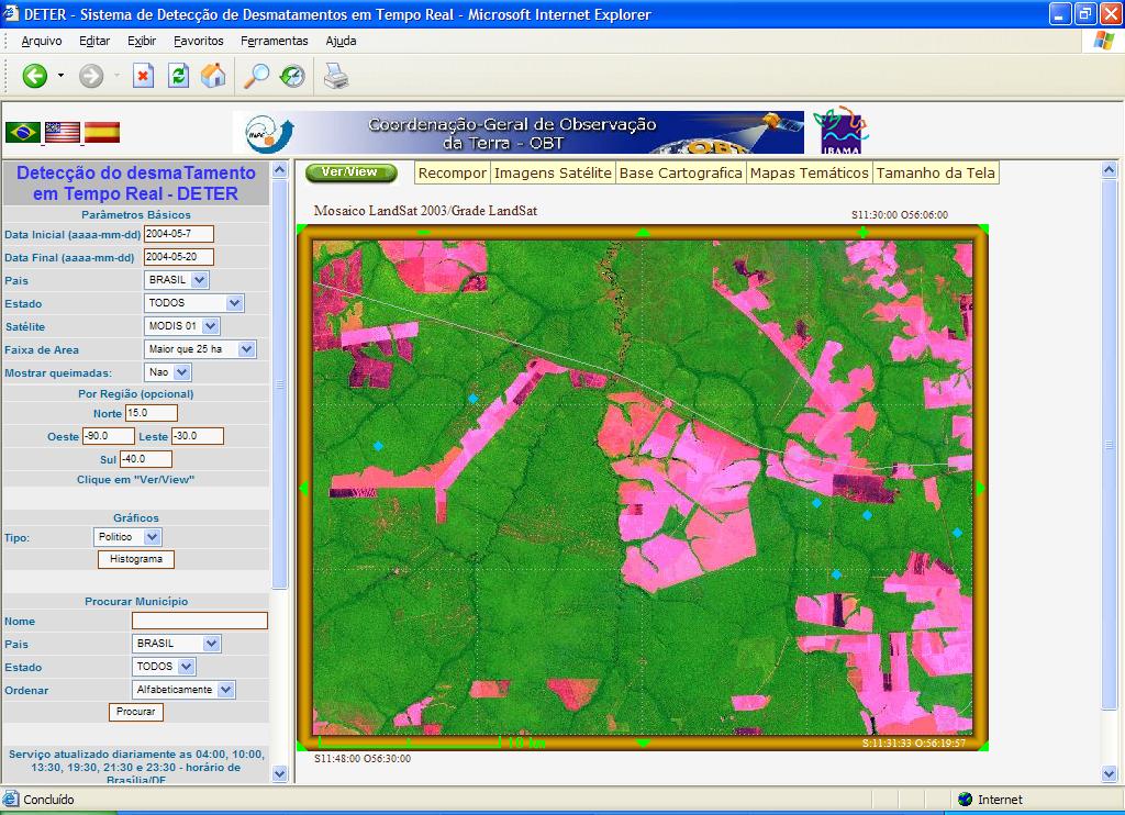
23 DETER Near Real Time Deforestation Detection with MODIS
24 EXTENSÃO TOTAL_AGOSTO 2003 SOBRE IMAGEM MODIS (22abr-07maio 2004)
25 CLASSIFICAÇÃO DA IMAGEM MODIS (mosaico 22 abril a 07 maio de 2004) EXTENSÃO TOTAL_AGOSTO MUDANÇA ATÉ 07 MAIO + IMAGEM
26 NOVA EXTENSÃO TOTAL ATÉ 07 DE MAIO DE 2004 SOBRE IMAGEM MODIS (22abr-07maio)
27 EXTENSÃO TOTAL ATÉ 07 DE MAIO DE 2004 SOBRE IMAGEM DE 21 MAIO
28 CLASSIFICAÇÃO DA IMAGEM MODIS DIÁRIA DE 21 DE MAIO DE 2004

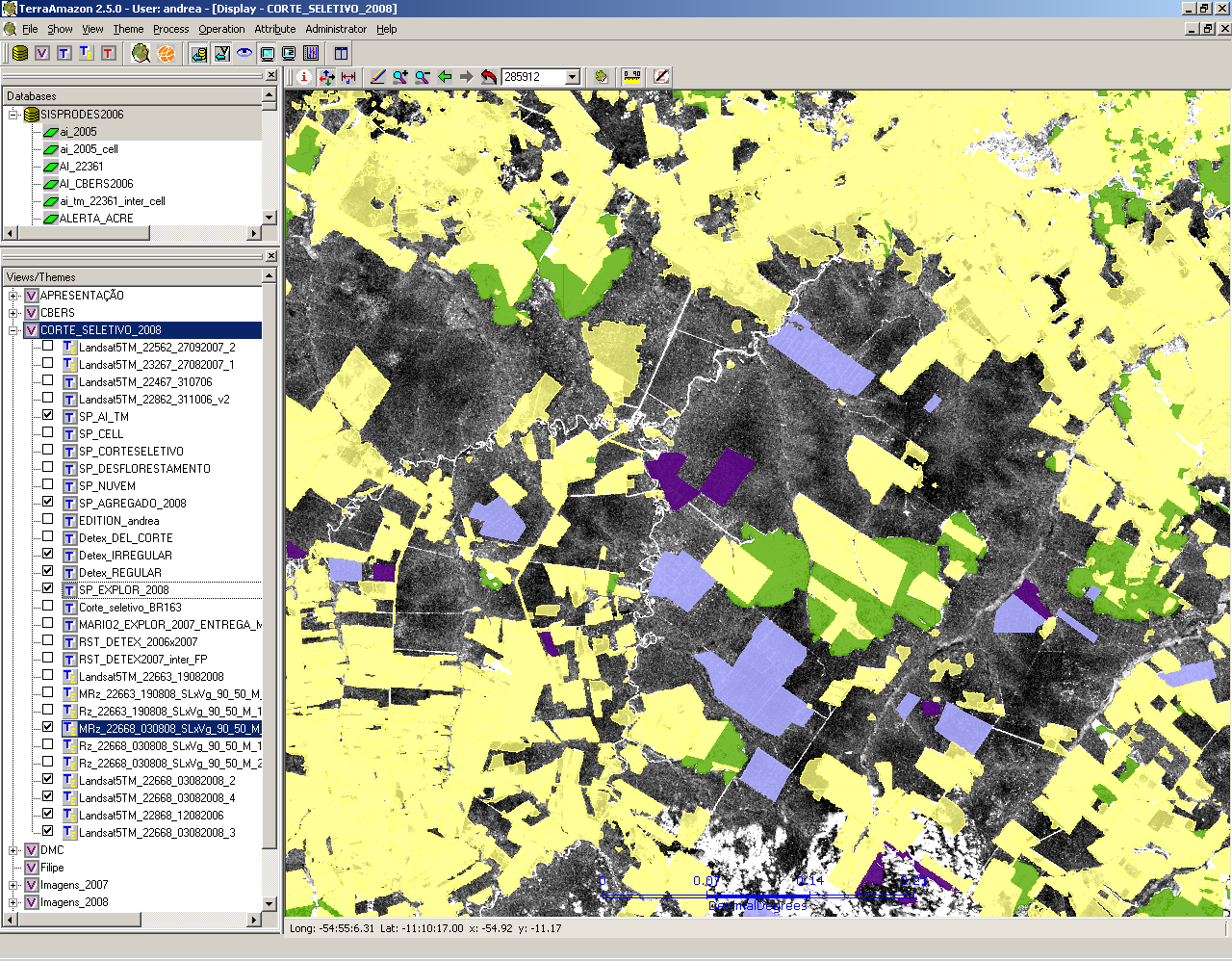
29

30

31 Report by automatic of New deforestation detected in Conservation Unities and municipalities
32 Impact of DETER Information for strategic decisions by deforestation control agencies - Federal, State and Municipal levels Better efficiency in law enforcement Immediate public awareness by monthly information dissemination (
 Amazonia-1 (40m, 5")
33 DETER New Paradigm MODIS 25 ha minimum mapping unity is today very limiting Need to move to better sensors Options ResourceSat/AWiFS DMC Future: CBERS3/AWFI (60m, 5 days) Amazonia-1 (40m, 5 days)
34 DETER-based Policies for Deforestation Control: Law Enforcement
35 Deforestation hotspots DETER 2011/INPE
36
37
38
39 Monitoring the State of the Forest: DEGRAD e DETEX
40
41
42
43
44
45 Corte seletivo Resultados Finais: 85 cenas UF 2007(KM2) 2008(KM2) Acre Amazonas Amapá Maranhão Mato Grosso Pará Rondônia Roraima Tocantins TOTAL
46 Corte seletivo Resultados Finais 2007 e 2008 Degradação em 2007 convertida a corte raso em 2008: UF Acre Amazonas Amapá Maranhão Mato Grosso Pará Rondônia Roraima Tocantins KM TOTAL
47
48 Thank you
49 INPE s Capacity Building Program in Remote Sensing Based Tropical Forest Monitoring Claudio Aparecido de Almeida Head, INPE - Regional Center for Amazonia ([email protected] )
50 Amazon Regional Center, Belem
51 Mission: INPE - Amazon Regional Center To assimilate and operate INPE s Amazon Monitoring Program To become an international reference in capacity building for satellite based tropical forest monitoring
52 INPE Amazônia Equipe Staff INPE Hired Scholarship Trainee Total

53 INPE Amazonia Staff/ Function 2011
54 Course Program (2 weeks) 1. Experience acquired with Amazon Program: PRODES, DETER, DEGRAD, TERRACLASS 2. Data base management 3. Terra family software 4. Cartography 5. Geographic data processing 6. TerraAmazon System Database administrator Digital image processing, edition, data analysis
55 INPE s open source image processing and geographic information analysis and management: TerraLib based Terra* family: SPRING
56 Participant profiles 1 - Database Administrator IT background Experience in data base management Government employee 2 - Remote Sensing Background in any Environmental Science Basic knowledge in remotes sensing Government employee
57 Current cooperation and training programs: FAO - 2 years,; 6 courses/year ; target : 200 students (Tropical countries) JICA-ABC 3 years, 3 course/year; IBAMA staff and Amazonian Countries 108 students already ACTO 2 years, 2 courses/year; ACTO countries; target 35 students and continued help-desk
58 JICA 2010 Bolivia, Colombia, Ecuador, Guatemala, Peru
59 JICA 2011 Angola, Mozambique, Paraguai
60 JICA 2011 Malasia, Thailand, Indonesia, Philippines, Cambodja e Vietnam
61 FAO Mexico, Ecuador, Guiana, FAO Headquarter
62 OTCA-2011 Bolivia, Ecuador, Colombia, Venezuela, Peru
63 FAO Inge Jonckheere (FAO) Claudio Almeida (INPE) Democratic Republic of Congo, Papua-New Guinea, Vietnam
64 Forests are not just Carbon! Biodiversity Environmental services People
65 Thank you again
Summary. Deforestation report for the Brazilian Amazon (February 2015) SAD
 SAD") Summary In February 2015, more than half (59%) of the forest area of the Brazilian Amazon was covered by clouds, a coverage lower than in February 2014 (69%). The States with the highest cloud cover were
Summary In February 2015, more than half (59%) of the forest area of the Brazilian Amazon was covered by clouds, a coverage lower than in February 2014 (69%). The States with the highest cloud cover were
National Institute for Space Research (INPE) Earth Science System Center (CCST)
 Earth Science System Center (CCST)") National Institute for Space Research (INPE) Earth Science System Center (CCST) Lincoln Muniz Alves [email protected] Acknowledgment: Ana Paula Aguiar, Milton Kampel, Simone Costa, Nelson Ferreira,
National Institute for Space Research (INPE) Earth Science System Center (CCST) Lincoln Muniz Alves [email protected] Acknowledgment: Ana Paula Aguiar, Milton Kampel, Simone Costa, Nelson Ferreira,
TerraAmazon - The Amazon Deforestation Monitoring System - Karine Reis Ferreira
 TerraAmazon - The Amazon Deforestation Monitoring System - Karine Reis Ferreira GEOSS Users & Architecture Workshop XXIV: Water Security & Governance - Accra Ghana / October 2008 INPE National Institute
INPE Spatial Data Infrastructure for Big Spatiotemporal Data Sets. Karine Reis Ferreira (INPE-Brazil)
") INPE Spatial Data Infrastructure for Big Spatiotemporal Data Sets Karine Reis Ferreira (INPE-Brazil) INPE (Brazil) and Big Data I work at INPE (Brazilian National Institute for Space Research). Main gate
INPE Spatial Data Infrastructure for Big Spatiotemporal Data Sets Karine Reis Ferreira (INPE-Brazil) INPE (Brazil) and Big Data I work at INPE (Brazilian National Institute for Space Research). Main gate
Report of the technical assessment of the proposed forest reference emission level of Brazil submitted in 2014
 United Nations FCCC/TAR/2014/BRA Distr.: General 1 December 2014 English only Report of the technical assessment of the proposed forest reference emission level of Brazil submitted in 2014 Summary This
A Hybrid Architecture for Mobile Geographical Data Acquisition and Validation Systems
 A Hybrid Architecture for Mobile Geographical Data Acquisition and Validation Systems Claudio Henrique Bogossian 1, Karine Reis Ferreira 1, Antônio Miguel Vieira Monteiro 1, Lúbia Vinhas 1 1 DPI Instituto
National and Sub-national Carbon monitoring tools developed at the WHRC
 National and Sub-national Carbon monitoring tools developed at the WHRC Nadine Laporte Woods Hole Research Center A. Baccini, W. Walker, S. Goetz, M. Sun, J. Kellndorfer Kigali, 20 th June 2011 Why measuring
Gabriel Lui (MMA - Ministry of Environment)
") Brazilian development towards forest degradation national definition and MRV system Gabriel Lui (MMA - Ministry of Environment) Dalton M. Valeriano (INPE) BMZ-DLR International Conference on MRV of REDD
Brazilian development towards forest degradation national definition and MRV system Gabriel Lui (MMA - Ministry of Environment) Dalton M. Valeriano (INPE) BMZ-DLR International Conference on MRV of REDD
ENVIRONMENTAL PERFORMANCE REVIEW OF BRAZIL. Main findings and recommendations
 ENVIRONMENTAL PERFORMANCE REVIEW OF BRAZIL Main findings and recommendations Nathalie Girouard and Ivana Capozza OECD Environment Directorate Brasília, 4 November 2015 Outline Brazil s economic and social
Analyzing temporal and spatial dynamics of deforestation in the Amazon: a case study in the Calha Norte region, State of Pará, Brazil
 Anais XV Simpósio Brasileiro de Sensoriamento Remoto - SBSR, Curitiba, PR, Brasil, 30 de abril a 05 de maio de 2011, INPE p.2756 Analyzing temporal and spatial dynamics of deforestation in the Amazon:
Tools for National Forest Monitoring Systems in the context of REDD+
 Tools for National Forest Monitoring Systems in the context of REDD+ Dr. Inge JONCKHEERE UN-REDD Team (FAO HQ Rome, Italy) INPE/FUNCATE Team (Sao Jose dos Campos, Brasil) ECOWAS GBEP REGIONAL BIOMASS RESOURCE
NEW BRAZILIAN ENVIRONMENTAL CRIMES LAW: AN ANALYSIS OF ITS EFFECTIVENESS TO PROTECT THE FORESTS OF AMAZONIA 1
 BRITO, BARRETO, ROTHMAN 285 NEW BRAZILIAN ENVIRONMENTAL CRIMES LAW: AN ANALYSIS OF ITS EFFECTIVENESS TO PROTECT THE FORESTS OF AMAZONIA 1 BRITO, BRENDA, 1 BARRETO, PAULO 2 and ROTHMAN, JOHN 3 1 Lawyer,
Manaus Free Trade Zone. Meeting with Taipei Delegation Brasília, October 25 th, 2013
 Manaus Free Trade Zone Meeting with Taipei Delegation Brasília, October 25 th, 2013 MANAUS FREE TRADE ZONE (ZFM) MANAGEMENT MODEL PRESIDENCY OF THE REPUBLIC Ministry of Development, Industry and Foreign
Using Remote Sensing to Monitor Soil Carbon Sequestration
 Using Remote Sensing to Monitor Soil Carbon Sequestration E. Raymond Hunt, Jr. USDA-ARS Hydrology and Remote Sensing Beltsville Agricultural Research Center Beltsville, Maryland Introduction and Overview
Evaluation of Wildfire Duration Time Over Asia using MTSAT and MODIS
 Evaluation of Wildfire Duration Time Over Asia using MTSAT and MODIS Wataru Takeuchi * and Yusuke Matsumura Institute of Industrial Science, University of Tokyo, Japan Ce-504, 6-1, Komaba 4-chome, Meguro,
e-sensing: Big Earth observation data analytics for land use and land cover change information
 e-sensing: Big Earth observation data analytics for land use and land cover change information Thematic Project (48 months) November 2014 October 2018 Project leader: Prof. Dr. Gilberto Câmara (INPE Instituto
Remote Sensing Method in Implementing REDD+
 Remote Sensing Method in Implementing REDD+ FRIM-FFPRI Research on Development of Carbon Monitoring Methodology for REDD+ in Malaysia Remote Sensing Component Mohd Azahari Faidi, Hamdan Omar, Khali Aziz
Selecting the appropriate band combination for an RGB image using Landsat imagery
 Selecting the appropriate band combination for an RGB image using Landsat imagery Ned Horning Version: 1.0 Creation Date: 2004-01-01 Revision Date: 2004-01-01 License: This document is licensed under a
Three Essential Strategies. For Reducing Deforestation. December 2007
 Aliança da Terra -- AT The Earth Alliance brings conscientious and committed landowners together with responsible agricultural production. The principal activity of AT is a Registry of Social-Environmental
Support period and budget frame, expenditures to date:
 1) Project Leaf - Law Enforcement Assistance for Forests 2) Project summary: Project Leaf (Law Enforcement Assistance for Forests) is a consortium forests and climate initiative on combating illegal logging
Monitoring alterations in vegetation cover and land use in the Upper Paraguay River Basin Brazilian Portion Period of Analysis: 2002 to 2008
 Monitoring alterations in vegetation cover and land use in the Upper Paraguay River Basin Brazilian Portion Period of Analysis: 2002 to 2008 Introduction The Upper Paraguay River Basin encompasses international
Changes in forest cover applying object-oriented classification and GIS in Amapa- French Guyana border, Amapa State Forest, Module 4
 Changes in forest cover applying object-oriented classification and GIS in Amapa- French Guyana border, Amapa State Forest, Module 4 Marta Vieira da Silva 1 Valdenira Ferreira dos Santos 2 Eleneide Doff
Brazil s Response to Lower Commodity Prices Will Infrastructure Improvements Support Further Expansion?
 Brazil s Response to Lower Commodity Prices Will Infrastructure Improvements Support Further Expansion? By Dr. Michael Cordonnier www.soybeansandcorn.com [email protected] 630-325-0192 (Chicago) Overview
VCS REDD Methodology Module. Methods for monitoring forest cover changes in REDD project activities
 1 VCS REDD Methodology Module Methods for monitoring forest cover changes in REDD project activities Version 1.0 May 2009 I. SCOPE, APPLICABILITY, DATA REQUIREMENT AND OUTPUT PARAMETERS Scope This module
Resolutions of Remote Sensing
 Resolutions of Remote Sensing 1. Spatial (what area and how detailed) 2. Spectral (what colors bands) 3. Temporal (time of day/season/year) 4. Radiometric (color depth) Spatial Resolution describes how
Services Help Desk for Sustainable Businesses Program in the Brazilian Amazon: An Analysis of Benefited Enterprises.
 Services Help Desk for Sustainable Businesses Program in the Brazilian Amazon: An Analysis of Benefited Enterprises (May 19, 2009) Amigos da Terra Amazônia Brasileira (DRAFT Not for Circulation) EXECUTIVE
APPLYING SATELLITE IMAGES CLASSIFICATION ALGORITHMS FOR SOIL COVER AND GEORESOURCES IDENTIFICATION IN NOVA LIMA, MINAS GERAIS - BRAZIL
 APPLYING SATELLITE IMAGES CLASSIFICATION ALGORITHMS FOR SOIL COVER AND GEORESOURCES IDENTIFICATION IN NOVA LIMA, MINAS GERAIS - BRAZIL Vladimir Diniz Vieira Ramos Universidade Federal de Minas Gerais Departamento
Integrated Global Carbon Observations. Beverly Law Prof. Global Change Forest Science Science Chair, AmeriFlux Network Oregon State University
 Integrated Global Carbon Observations Beverly Law Prof. Global Change Forest Science Science Chair, AmeriFlux Network Oregon State University Total Anthropogenic Emissions 2008 Total Anthropogenic CO 2
Admission to UNICAMP. 1. The Undergraduate Program. 1.1. Regular students. 1.1.1 The vestibular examination. 1.1.2.
 Admission to UNICAMP 1. The Undergraduate Program 1.1. Regular students To enroll as a regular student in one of UNICAMP's undergraduate courses, foreign students have to pass the entrance examination
Using Remote Sensing Imagery to Evaluate Post-Wildfire Damage in Southern California
 Graham Emde GEOG 3230 Advanced Remote Sensing February 22, 2013 Lab #1 Using Remote Sensing Imagery to Evaluate Post-Wildfire Damage in Southern California Introduction Wildfires are a common disturbance
ArcGIS Agricultural Land Use Maps from the Mississippi Cropland Data Layer
 ArcGIS Agricultural Land Use Maps from the Mississippi Cropland Data Layer Fred L. Shore, Ph.D. Mississippi Department of Agriculture and Commerce Jackson, MS, USA [email protected] Rick Mueller
TARAPOTO PROCESS ON THE AMAZON FOREST S SUSTAINABILITY CRITERIA AND INDICATORS
 TARAPOTO PROCESS ON THE AMAZON FOREST S SUSTAINABILITY CRITERIA AND INDICATORS INTERNATIONAL EXPERT MEETING ON MONITORING, ASSESSMENT AND REPORTING ON THE PROGRESS TOWARD SUSTAINABLE FOREST MANAGEMENT
REDD in Brazil: A focus on the Amazon
 Center for Strategic Studies and Management Science, Technology & Innovation REDD in Brazil: A focus on the Amazon Principles, criteria, and institutional structures for a national program for Reducing
HIGH RESOLUTION REMOTE SENSING AND GIS FOR URBAN ANALYSIS: CASE STUDY BURITIS DISTRICT, BELO HORIZONTE, MINAS GERAIS
 HIGH RESOLUTION REMOTE SENSING AND GIS FOR URBAN ANALYSIS: CASE STUDY BURITIS DISTRICT, BELO HORIZONTE, MINAS GERAIS Hermann Johann Heinrich Kux Senior Researcher III INPE, Remote Sensing Division DAAD
Forest Fire Information System (EFFIS): Rapid Damage Assessment
: Rapid Damage Assessment") Forest Fire Information System (EFFIS): Fire Danger D Rating Rapid Damage Assessment G. Amatulli, A. Camia, P. Barbosa, J. San-Miguel-Ayanz OUTLINE 1. Introduction: what is the JRC 2. What is EFFIS 3.
Forest Fire Information System (EFFIS): Fire Danger D Rating Rapid Damage Assessment G. Amatulli, A. Camia, P. Barbosa, J. San-Miguel-Ayanz OUTLINE 1. Introduction: what is the JRC 2. What is EFFIS 3.
Technical paper. Summary
 UNITED NATIONS Distr. GENERAL FCCC/TP/2009/1 31 May 2009 ENGLISH ONLY Cost of implementing methodologies and monitoring systems relating to estimates of emissions from deforestation and forest degradation,
Processing of Fire Service Products for Wildfire Monitoring in Tanzania at MESA TAFORI Fire Station: The use of ArcGIS Software
 Processing of Fire Service Products for Wildfire Monitoring in Tanzania at MESA TAFORI Fire Station: The use of ArcGIS Software 1 S. Ernest* 1 Tanzania Forestry Research Institute (TAFORI), P.O Box 1854,
The State of Forests in the Amazon Basin, Congo Basin and Southeast Asia
 The State of Forests in the Amazon Basin, Congo Basin and Southeast Asia A report prepared for the Summit of the Three Rainforest Basins Brazzaville, Republic of Congo 31 May 3 June, 2011 The State of
Industrial area with Hangar. Land area: 90.000 sqm Hangar area: 5.000 sqm Office area: 250 sqm Brazil Espírito Santo Serra Highway BR 101 North
 Industrial area with Hangar Land area: 90.000 sqm Hangar area: 5.000 sqm Office area: 250 sqm Brazil Espírito Santo Serra Highway BR 101 North Property Location Brasil, Espírito Santo, Serra - Highway
A remote sensing instrument collects information about an object or phenomenon within the
 Satellite Remote Sensing GE 4150- Natural Hazards Some slides taken from Ann Maclean: Introduction to Digital Image Processing Remote Sensing the art, science, and technology of obtaining reliable information
SPREADSHEET EDUCATION MATERIAL USING REMOTE SENSING IMAGE AND MAP IMAGE
 SPREADSHEET EDUCATION MATERIAL USING REMOTE SENSING IMAGE AND MAP IMAGE Kiyotada Sato a, *, Ryuzo Yokoyama b a Ichinoseki National College of Technology Mechanical Engineering, Hagisho Ichinoseki City,
A KNOWLEDGE-BASED APPROACH FOR REDUCING CLOUD AND SHADOW ABSTRACT
 A KNOWLEDGE-BASED APPROACH FOR REDUCING CLOUD AND SHADOW Mingjun Song, Graduate Research Assistant Daniel L. Civco, Director Laboratory for Earth Resources Information Systems Department of Natural Resources
Estimating Central Amazon forest structure damage from fire using sub-pixel analysis
 Estimating Central Amazon forest structure damage from fire using sub-pixel analysis Angélica Faria de Resende 1 Bruce Walker Nelson 1 Danilo Roberti Alves de Almeida 1 1 Instituto Nacional de Pesquisas
MODIS IMAGES RESTORATION FOR VNIR BANDS ON FIRE SMOKE AFFECTED AREA
 MODIS IMAGES RESTORATION FOR VNIR BANDS ON FIRE SMOKE AFFECTED AREA Li-Yu Chang and Chi-Farn Chen Center for Space and Remote Sensing Research, National Central University, No. 300, Zhongda Rd., Zhongli
Review for Introduction to Remote Sensing: Science Concepts and Technology
 Review for Introduction to Remote Sensing: Science Concepts and Technology Ann Johnson Associate Director [email protected] Funded by National Science Foundation Advanced Technological Education program [DUE
ANALYSIS OF FOREST CHANGE IN FIRE DAMAGE AREA USING SATELLITE IMAGES
 ANALYSIS OF FOREST CHANGE IN FIRE DAMAGE AREA USING SATELLITE IMAGES Joon Mook Kang, Professor Joon Kyu Park, Ph.D Min Gyu Kim, Ph.D._Candidate Dept of Civil Engineering, Chungnam National University 220
Remote Sensing an Introduction
 Remote Sensing an Introduction Seminar: Space is the Place Referenten: Anica Huck & Michael Schlund Remote Sensing means the observation of, or gathering information about, a target by a device separated
Improving global data on forest area & change Global Forest Remote Sensing Survey
 Improving global data on forest area & change Global Forest Remote Sensing Survey work by FAO and partners - Adam Gerrand, E. Lindquist, R. D Annunzio, M. Wilkie, FAO, - F. Achard et al. TREES team at
Votorantim Industrial Sustainability Report. External Audience
 Votorantim Industrial Sustainability Report External Audience Message from the Senior Management In Votorantim Group s 93 years of history, we have maintained stability and consistency in creating value,
Assessing Hurricane Katrina Damage to the Mississippi Gulf Coast Using IKONOS Imagery
 Assessing Hurricane Katrina Damage to the Mississippi Gulf Coast Using IKONOS Imagery Joseph P. Spruce Science Systems and Applications, Inc. John C., MS 39529 Rodney McKellip NASA Project Integration
Netherlands Climate Change Studies Assistance Programme. Kees Dorland
 Netherlands Climate Change Studies Assistance Programme Kees Dorland The Netherlands Climate Change Studies Assistance Programme funded by: the Netherlands, Dirtectorate General for Development Co-operation,
TerraColor White Paper
 TerraColor White Paper TerraColor is a simulated true color digital earth imagery product developed by Earthstar Geographics LLC. This product was built from imagery captured by the US Landsat 7 (ETM+)
Brazil February Production Update and Weekly Crop Condition Report
 February 27, 2014 Informa Economics South American Crop Reporting Service Brazil February Production Update and Weekly Crop Condition Report The Informa Economics staff in Brazil conducted its survey between
Remote Sensing and GIS Application In Change Detection Study In Urban Zone Using Multi Temporal Satellite
 Remote Sensing and GIS Application In Change Detection Study In Urban Zone Using Multi Temporal Satellite R.Manonmani, G.Mary Divya Suganya Institute of Remote Sensing, Anna University, Chennai 600 025
Australia s National Carbon Accounting System. Dr Gary Richards Director and Principal Scientist
 Australia s National Carbon Accounting System Dr Gary Richards Director and Principal Scientist Government Commitment The Australian Government has committed to a 10 year, 3 phase, ~$35M program for a
Anais XVI Simpósio Brasileiro de Sensoriamento Remoto - SBSR, Foz do Iguaçu, PR, Brasil, 13 a 18 de abril de 2013, INPE
 Image processing and land-cover change analysis in the tri-national frontier of Madre de Dios (Peru), Acre (Brazil), and Pando (Bolivia) - MAP: an increasing demand for data standardization Karla da Silva
Land Use/ Land Cover Mapping Initiative for Kansas and the Kansas River Watershed
 Land Use/ Land Cover Mapping Initiative for Kansas and the Kansas River Watershed Kansas Biological Survey Kansas Applied Remote Sensing Program April 2008 Previous Kansas LULC Projects Kansas LULC Map
WATER BODY EXTRACTION FROM MULTI SPECTRAL IMAGE BY SPECTRAL PATTERN ANALYSIS
 WATER BODY EXTRACTION FROM MULTI SPECTRAL IMAGE BY SPECTRAL PATTERN ANALYSIS Nguyen Dinh Duong Department of Environmental Information Study and Analysis, Institute of Geography, 18 Hoang Quoc Viet Rd.,
Welcome to NASA Applied Remote Sensing Training (ARSET) Webinar Series
 Webinar Series") Welcome to NASA Applied Remote Sensing Training (ARSET) Webinar Series Introduction to Remote Sensing Data for Water Resources Management Course Dates: October 17, 24, 31 November 7, 14 Time: 8-9 a.m.
Welcome to NASA Applied Remote Sensing Training (ARSET) Webinar Series Introduction to Remote Sensing Data for Water Resources Management Course Dates: October 17, 24, 31 November 7, 14 Time: 8-9 a.m.
SAMPLE MIDTERM QUESTIONS
 Geography 309 Sample MidTerm Questions Page 1 SAMPLE MIDTERM QUESTIONS Textbook Questions Chapter 1 Questions 4, 5, 6, Chapter 2 Questions 4, 7, 10 Chapter 4 Questions 8, 9 Chapter 10 Questions 1, 4, 7
Moderate- and high-resolution Earth Observation data based forest and agriculture monitoring in Russia using VEGA Web-Service
 Moderate- and high-resolution Earth Observation data based forest and agriculture monitoring in Russia using VEGA Web-Service Sergey BARTALEV and Evgeny LOUPIAN Space Research Institute, Russian Academy
How To Map Forest Change With A Gca
 Resumo. ImgTools: a software for optical remotely sensed data analysis Carlos Moreira de Souza Junior. 1 João Victor Nascimento Siqueira 1 1 Instituto do Homem e Meio Ambiente da Amazônia - Imazon Rua
Multi-Temporal Wild Fire Monitoring in Lao PDR using MODIS Data
 Multi-Temporal Wild Fire Monitoring in Lao PDR using MODIS Data Vivarad Phonekeo Ph. D. Geoinformatics Center (GIC) Asian Institute of Technology [email protected], [email protected] www.vivarad.info Thatheva
Digital image processing
 746A27 Remote Sensing and GIS Lecture 4 Digital image processing Chandan Roy Guest Lecturer Department of Computer and Information Science Linköping University Digital Image Processing Most of the common