Surface water flood forecasting and guidance in the UK: theory, performance and outlook" RainGain National Observers Group (NOG) Meeting 16 April 2013
|
|
|
- Frederica Lee
- 8 years ago
- Views:
Transcription


1 Surface water flood forecasting and guidance in the UK: theory, performance and outlook" RainGain National Observers Group (NOG) Meeting 16 April 2013 Dr Andy Lane Senior Hydrometeorologist

2 Overview Flood Forecasting Centre Developing our surface water flood forecasting capabilities Outlook

3 Flood Forecasting Centre
4 What is the FFC? Successful partnership between the Met Office and Environment Agency; Remit to forecast for all sources of flooding; Operational since April 2009 delivering 24/7 services; Combine staff expertise in hydrometeorology to provide improved and new services Agreed outcomes with three year delivery plan Permanent base in MO Exeter DEFRA funded inc. national contributions

5 Our Services Government Services England, Wales & Local Flood Advisory Services Cat 1 and 2 Services Flood Guidance Statements, Hazard Manager, Consultancy, materials and training Environment Agency English Regions and Wales Hydromet Services: Guidance, Heavy Rainfall Alerts & Forecast Met Data UKCMF Services Outlooks, alerts and consultancy for the UK coast inc Scotland & NI Public Services Public Flood Risk Forecast

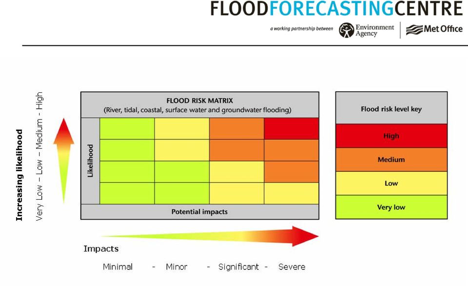
 determined using a flood risk matrix, combining likelihood and impact of flooding Email and Fax to 2500+ government and emergency")
6 Flood Guidance Statement (FGS) Five day national, county level forecast of flood risk for England & Wales Issued daily, and more frequently at times of higher risk Risk (colour) determined using a flood risk matrix, combining likelihood and impact of flooding and Fax to government and emergency responders

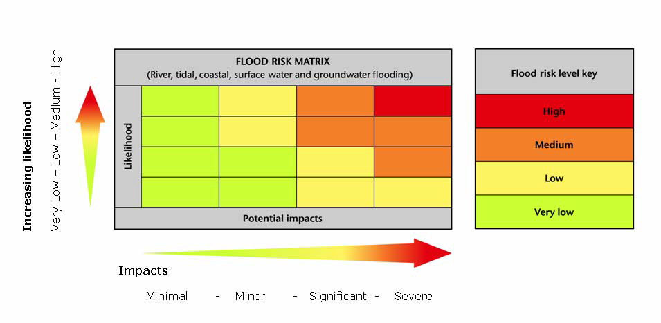
7 Determining flood risk
8 Our Delivery Plan Priorities 1. 24/7 hydrometeorological service enabling all our partners to be better prepared for flooding. 2. Understand our customers, lead in the integration of flood services and help them to understand how they can best use our products and services. 3. Develop our forecasting capabilities further 4. Develop and promote the FFC as a centre of expertise in hydrometeorology

9 Developing our surface water flood forecasting capabilities


10 1 st Generation Extreme Rainfall Alerts in 30 year return period rainfall depth-duration thresholds 30mm/hour, 40mm/3hours and 50mm/6hours Issued at county level to alert for extreme rainfall that could lead to severe surface water flooding in urban areas Issued on 20% probability of meeting the thresholds

11 2 nd Generation - Surface Water Flooding Decision Support Tool (SWFDST) present Project with Halcrow ( ) Examined rainfall and other criteria (SMD, API, Urban Extent etc) that exacerbate SWF Shortlisted main ones where data available Tested these criteria against flood and non-flood events (surface water) Iterative process to find best weightings of these criteria using POD/FAR/CSI Developed an operational tool
 Iterative process to find best weightings of these criteria using POD/FAR/CSI Developed an")
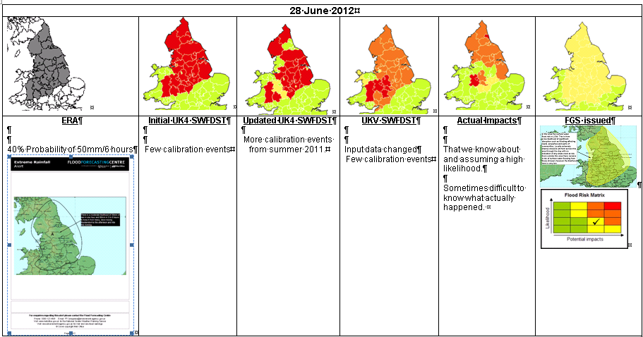
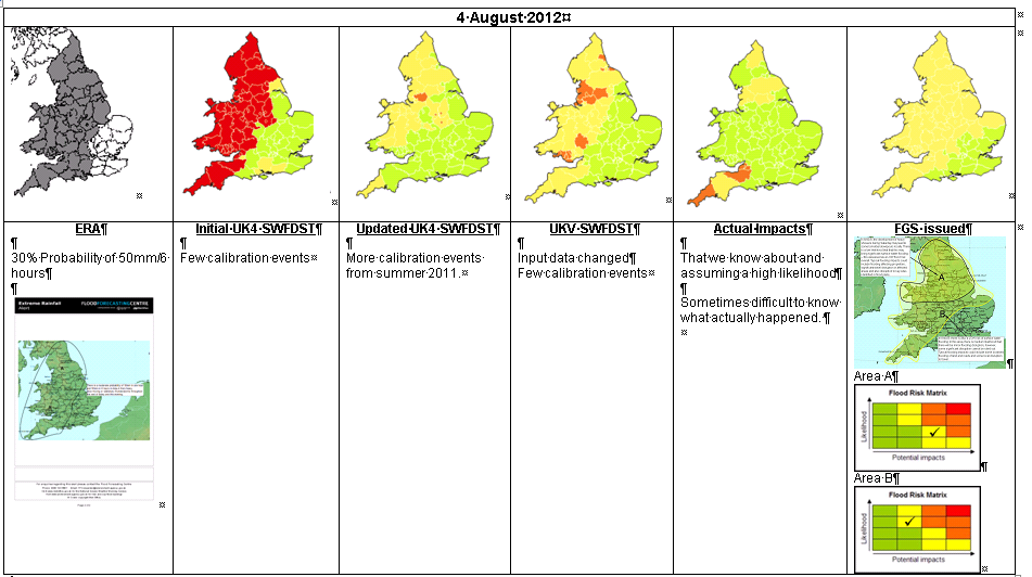
12 2 nd Generation Initial UK4 SWFDST County ID and County/Unitary Authority Blue Square % per county/unitary authority. Each 1km blue square indicates where at least 200 people, 20 businesses or 1 critical service might be flooded to a depth of 0.3m by a 1 in 200 year rainfall event (using the EA s Flood Map for Surface Water) Experienced based assessment of likely impact of meteorological hazard. For example, fast moving, single cell thunderstorms generally have less flood impact than slow moving, back building thunderstorms. Extreme Rainfall Alert probabilities from 4km NWP model. Thresholds used are 40mm/3hr and 50mm/6hr. Weighted Score equivalent to flood risk level for 3 categories of blue square % calibrated with event data

13 Winter 2011/12 2 nd Generation Updated UK4 SWFDST Recalibrated with summer 2011 rainfall and flood impact data Winter 2012/13 2 nd Generation UKV SWFDST Parameters that can exacerbate SWF re-assessed using rainfall and flood impact data collected over summer 2012 and previous years. Spreadsheet re-weighted based upon this new parameter set. Re-calibrated to use UKV 1.5km (not UK4 4km) Extreme Rainfall Alert probability data.

14 2 nd Generation UKV SWFDST County ID and County/Unitary Authority Blue Square % per county/unitary authority. Each 1km blue square indicates where at least 200 people, 20 businesses or 1 critical service might be flooded to a depth of 0.3m by a 1 in 200 year rainfall event (using the EA s Flood Map for Surface Water) Experienced based assessment of likely impact of meteorological hazard. For example, fast moving, single cell thunderstorms generally have less flood impact than slow moving, back building thunderstorms. Maximum probability value from all three 1 in 10 and all three 1 in 30 year return period UKV (1.5km NWP model) Extreme Rainfall Alert Probabilities. Soil Moisture Deficit value. <=6mm the catchment is considered wet and assigned a SMD score of 100%. >6mm 10 year return periods 30 year return periods SMD score decreases inversely (score = 6mm/SMD(mm)) 20 mm / hour 30 mm / hour 30 mm / 3 hours 40 mm / 3 hours 40mm / 6 hours Weighted Score 50mm equivalent / 6 hours to flood risk level for 3 categories of blue square % calibrated with flood event data

15 Surface Water Flood Forecasting process SWFDST Initial assessment Consultation Environment Agency regional flood forecasting teams Met Office Civil Contingency Advisors Met Office Chief Forecaster Look at other NWP models MOGREPS-UK ECMWF...etc Produce Flood Guidance Statement

16

17


18

19 Outlook


20 FFC Targets to reliably forecast at county scale: Amber - Day Red - Day


21 How could FGS be improved? There could be more regional based when Amber alerts or above are issued. e.g. West Mids very large area more detailed maps of the expected locations likely to receive the impacts would be useful Improve the visual representation of the UK. Some of the smaller geographical representations of counties are not easy to distinguish against neighbouring counties. i.e. North Somerset
22 3 rd Generation Hazard Impact Modelling
23 Natural Hazards Partnership
24
25 3 rd Generation Hazard Impact Modelling

26 3 rd Generation Hazard Impact Modelling
27 Questions?
JASPERS Networking Platform
 JASPERS Networking Platform Promoting climate change adaptation, risk prevention and management in the Water Sector UK Emergency Warning System Rachel Brisley, Technical Director & Sophie Dusting, Analyst
Real-time modelling of surface water flooding hazard and impact at countrywide scales
 Real-time modelling of surface water flooding hazard and impact at countrywide scales Steven Cole 1, Robert Moore 1, Paul Mattingley 1,Timothy Aldridge 2, Jon Millard 3,4 and Stefan Laeger 5 BHS National
Real-time hazard impact modelling for surface water flooding: some UK developments
 Real-time hazard impact modelling for surface water flooding: some UK developments Steven Cole 1, Bob Moore 1, Timothy Aldridge 2, Andy Lane 3,4 and Stefan Laeger 4 International Conference on Flood Resilience,
Surface Water Flooding
 Surface Water Flooding Nick Reynard Science Area Leader: Natural Hazards CEH Wallingford Contributions from: Bob Moore, Steve Cole, Joint COST - WssTP Strategic Conference, 17 April 2013 CEH RESEARCH ON
My presentation will be on rainfall forecast alarms for high priority rapid response catchments.
 Hello everyone My presentation will be on rainfall forecast alarms for high priority rapid response catchments. My name is Oliver Pollard. I have over 20 years hydrological experience with the Environment
APPENDIX A : 1998 Survey of Proprietary Risk Assessment Systems
 APPENDIX A : 1998 Survey of Proprietary Risk Assessment Systems In its 1997 paper, the working party reported upon a survey of proprietary risk assessment systems designed for use by UK household insurers
MOGREPS status and activities
 MOGREPS status and activities by Warren Tennant with contributions from Rob Neal, Sarah Beare, Neill Bowler & Richard Swinbank Crown copyright Met Office 32 nd EWGLAM and 17 th SRNWP meetings 1 Contents
Bolton s Flood Risk Management Strategy
 Bolton s Flood Risk Management Strategy www.bolton.gov.uk Public Summary Bolton s Flood Risk Management Strategy Public Summary Introduction Over 5.5 million properties in England and Wales are at risk
The Association of Drainage Authorities Response to the: A National Flood Emergency Framework Proposals for consultation
 Version 1.0 27.03.2009 Dr Jean Venables OBE FREng Chief Executive Please respond to: David Sisson CEng MCIWEM Operations Director Address: Wellington House, Manby Park, Louth, Lincolnshire, LN11 8UU Web:
Scottish Flood Forecasting Service. Working in partnership. Your guide to using the Flood Guidance Statement Third publication
 Scottish Flood Forecasting Service Working in partnership Your guide to using the Flood Guidance Statement Third publication Flooding in recent years, across many parts of the country, has reminded people
Verifying Extreme Rainfall Alerts for surface water flooding potential. Marion Mittermaier, Nigel Roberts and Clive Pierce
 Verifying Extreme Rainfall Alerts for surface water flooding potential Marion Mittermaier, Nigel Roberts and Clive Pierce Pluvial (surface water) flooding Why Extreme Rainfall Alerts? Much of the damage
Flash Flood Science. Chapter 2. What Is in This Chapter? Flash Flood Processes
 Chapter 2 Flash Flood Science A flash flood is generally defined as a rapid onset flood of short duration with a relatively high peak discharge (World Meteorological Organization). The American Meteorological
Managing sewer flood risk
 Managing sewer flood risk J. Ryu 1 *, D. Butler 2 1 Environmental and Water Resource Engineering, Department of Civil and Environmental Engineering, Imperial College, London, SW7 2AZ, UK 2 Centre for Water
Groundwater Flooding: a UK Perspective
 Groundwater Flooding: a UK Perspective David Macdonald British Geological Survey Maclean Building Crowmarsh Gifford Wallingford OX10 8BB Tel 01491 838800 NERC All rights reserved Talk outline Definition
Solar Performance Mapping and Operational Yield Forecasting
 Solar Performance Mapping and Operational Yield Forecasting Supported by Innovate UK Crown copyright Met Office The thing is that Project Overview A collaborative project led by the BRE National Solar
www.gov.uk/defra The National Flood Emergency Framework for England December 2014
 www.gov.uk/defra The National Flood Emergency Framework for England December 2014 Crown copyright 2014 You may re-use this information (not including logos) free of charge in any format or medium, under
Flooding from groundwater
 Flooding from groundwater Improved flood warning service - frequently asked questions General 1 - What is flooding from groundwater? 2 - Who deals with flooding from groundwater? 3 - How do I find out
Appendix C - Risk Assessment: Technical Details. Appendix C - Risk Assessment: Technical Details
 Appendix C - Risk Assessment: Technical Details Page C1 C1 Surface Water Modelling 1. Introduction 1.1 BACKGROUND URS Scott Wilson has constructed 13 TUFLOW hydraulic models across the London Boroughs
Flood Incident Management - the next ten years
 Flood Incident Management - the next ten years Consultation on the future of FlM in England and Wales, Aug Oct 2012 Table of Contents 1. About this consultation 3 1.1 Introduction 1.2 Why are we consulting?
CORRELATIONS BETWEEN RAINFALL DATA AND INSURANCE DAMAGE DATA ON PLUVIAL FLOODING IN THE NETHERLANDS
 10 th International Conference on Hydroinformatics HIC 2012, Hamburg, GERMANY CORRELATIONS BETWEEN RAINFALL DATA AND INSURANCE DAMAGE DATA ON PLUVIAL FLOODING IN THE NETHERLANDS SPEKKERS, M.H. (1), TEN
06 - NATIONAL PLUVIAL FLOOD MAPPING FOR ALL IRELAND THE MODELLING APPROACH
 06 - NATIONAL PLUVIAL FLOOD MAPPING FOR ALL IRELAND THE MODELLING APPROACH Richard Kellagher 1, Mike Panzeri 1, Julien L Homme 1, Yannick Cesses 1, Ben Gouldby 1 John Martin 2, Oliver Nicholson 2, Mark
Improved Warnings for Natural Hazards: A Prototype System for Southern California
 Improved Warnings for Natural Hazards: A Prototype System for Southern California Yehuda Bock Research Geodesist Scripps Institution of Oceanography University of California San Diego, La Jolla, Calif.
Design and Deployment of Specialized Visualizations for Weather-Sensitive Electric Distribution Operations
 Fourth Symposium on Policy and Socio-Economic Research 4.1 Design and Deployment of Specialized Visualizations for Weather-Sensitive Electric Distribution Operations Lloyd A. Treinish IBM, Yorktown Heights,
Education case study
 1 2012 brought numerous flooding events to the UK. This case study focuses on one week in November when four periods of rainfall brought widespread flooding to many parts of the UK. Meteorological situation
WET10 - THE CITY WATER DEBATE 2015. When Will London Flood? Introduction. Dr Paul Leinster, CBE
 WET10 - THE CITY WATER DEBATE 2015 When Will London Flood? Introduction Roger Hewitt, Past Master of the Water Conservators, opened the event by thanking the Worshipful Companies of the Glaziers and the
DA5a Water abstracted for agricultural use
 Observatory monitoring framework indicator data sheet Environmental impact: Water Indicator DA5: Water abstraction for agriculture This indicator shows the recorded quantity of water abstracted from surface
Monsoon Variability and Extreme Weather Events
 Monsoon Variability and Extreme Weather Events M Rajeevan National Climate Centre India Meteorological Department Pune 411 005 rajeevan@imdpune.gov.in Outline of the presentation Monsoon rainfall Variability
Flood risk assessment through a detailed 1D/2D coupled model
 CORFU Project Barcelona Case Study Final Workshop 19 th of May 2014 Flood risk assessment through a detailed 1D/2D coupled model Beniamino Russo Aqualogy Urban Drainage Direction Introduction and general
Flood warnings. What they are and what they do. A guide to the Environment Agency s flood warning codes
 Flood warnings What they are and what they do A guide to the Environment Agency s flood warning codes We are the Environment Agency. It s our job to look after your environment and make it a better place
FLOOD FORECASTING PRACTICE IN NORTHERN CALIFORNIA
 FLOOD FORECASTING PRACTICE IN NORTHERN CALIFORNIA California Department of Water Resources Post Office Box 219000, Sacramento, California 95821 9000 USA By Maurice Roos, Chief Hydrologist ABSTRACT Although
Climate Extremes Research: Recent Findings and New Direc8ons
 Climate Extremes Research: Recent Findings and New Direc8ons Kenneth Kunkel NOAA Cooperative Institute for Climate and Satellites North Carolina State University and National Climatic Data Center h#p://assessment.globalchange.gov
Assessing the Effects of Flood Resilient Technologies
 S. Golz 1, R. Schinke 1, T. Naumann 1, S. Garvin 2, I. White 3 Assessing the Effects of Flood Resilient Technologies International Conference on Flood Resilience 5-7 September 2013, Exeter (GBR) 1 Leibniz-Institute
FLOOD RISK RECENT TRENDS AND POLICY RESPONSES
 FLOOD RISK RECENT TRENDS AND POLICY RESPONSES DEVELOPING WESTMINSTER S LOCAL PLAN Booklet No. 2 LDF Consultation - CMP Revision November 2013 INTRODUCTION CLLR ROBERT DAVIS Westminster is at risk of flooding
 1 2 A very short description of the functional center network: regarding the Hydraulic and Hydrogeological risk, the national alert system is ensured by the National Civil Protection Department (DPCN),
Essex County Council Flood Investigation Report
 Essex County Council Stock City of Chelmsford Rev Date Details Author Checked and Approved By 01 February 2015 Draft report for stakeholder consultation Ed Clarke Flood Investigation Engineer Lucy Shepherd
PWS CSA 09-14 Annex B1. Appendix A.1 Detailed Output Definitions - PWS Outputs
 PWS CSA 09-14 Annex B1 Appendix A.1 Detailed Output Definitions - PWS Outputs 1a - High Impact weather forecast service - UK Requirement - To enable the UK public and emergency responders to take appropriate
chapter 9 conduct a climate change
 CONDUCT A CLIMATE RESILIENCY STUDY The following chapters recommend how to reach CRC Milestone Two, Conduct a Climate Resiliency Study. 2 MILESTONE Chapter 8: Conduct a Climate Change Vulnerability Assessment
UK Flooding April to July
 UK Flooding April to July Prepared by JBA Risk Management Limited and Met Office July JBA Risk Management Limited Met Office www.jbarisk.com www.metoffice.gov.uk Overview After a very dry start to the
Nowcasting: analysis and up to 6 hours forecast
 Nowcasting: analysis and up to 6 hours forecast Very high resoultion in time and space Better than NWP Rapid update Application oriented NWP problems for 0 6 forecast: Incomplete physics Resolution space
Application of Google Earth for flood disaster monitoring in 3D-GIS
 Disaster Management and Human Health Risk II 271 Application of Google Earth for flood disaster monitoring in 3D-GIS M. Mori & Y. L. Chan Department of Information and Computer Science, Kinki University,
River Flooding and the Grid-to-Grid Hydrological Model
 River Flooding and the Grid-to-Grid Hydrological Model Summary of Impacts Impact Mitigating the annual costs of damage from ordinary river flooding Mitigating the costs of damage from extreme river flooding
Texas Department of Public Safety Texas Division of Emergency Management. Texas State Operations Center
 Texas Department of Public Safety Texas Division of Emergency Management Texas State Operations Center Situation Awareness Brief Saturday, July 20 th 2013 As of 0900 CDT Tropical Weather Outlook For the
FLOOD CONTINGENCY PLAN
 Unrestricted Copy DERBYSHIRE LOCAL RESILIENCE FORUM FLOOD CONTINGENCY PLAN Issued January 2013 Revised Flood Contingency Plan CONTENTS CONTENTS RECORD OF AMENDMENTS CIRCULATION LIST Page i iii iv 1 BACKGROUND
Climate Change Adaptation for London s Transport System
 Climate Change Adaptation for London s Transport System Helen Woolston London Climate Change Partnership, 1 Contents This presentation will cover: London Climate Change Partnership Climate Change Adaptation
Water attenuation performance of experimental green roofs at Ruislip Gardens London Underground Depot Report 1 - July 2013
 Water attenuation performance of experimental green roofs at Ruislip Gardens London Underground Depot Report 1 - July 2013 1 Water attenuation performance of experimental green roofs at Ruislip Gardens
An innovative approach to Floods and Fire Risk Assessment and Management: the FLIRE Project
 8 th International Conference of EWRA Water Resources Management in an Interdisciplinary and Changing Context 26-29 June 2013, Porto, Portugal An innovative approach to Floods and Fire Risk Assessment
Analysis of pluvial flood damage based on data from insurance companies in the Netherlands
 Analysis of pluvial flood damage based on data from insurance companies in the Netherlands M.H. Spekkers 1, J.A.E. ten Veldhuis 1, M. Kok 1 and F.H.L.R. Clemens 1 1 Delft University of Technology, Department
FLOODALERT: A SIMPLIFIED RADAR-BASED EWS FOR URBAN FLOOD WARNING
 11 th International Conference on Hydroinformatics HIC 2014, New York City, USA FLOODALERT: A SIMPLIFIED RADAR-BASED EWS FOR URBAN FLOOD WARNING XAVIER LLORT (1), RAFAEL SÁNCHEZ-DIEZMA (1), ÁLVARO RODRÍGUEZ
Finnish Meteorological Institute s Services for Insurance Sector
 Finnish Meteorological Institute s Services for Insurance Sector Regional training workshop Role of the NMHSs in support of DRR- related activities in the field of insurance Janne Miettinen, Account Manager,
INSTALLATION OF AN AUTOMATED EARLY WARNING SYSTEM FOR ANNOTTO BAY
 TERMS OF REFERENCE INSTALLATION OF AN AUTOMATED EARLY WARNING SYSTEM FOR ANNOTTO BAY A Community Disaster Risk Reduction Project funded through the Building Disaster Resilient Communities Project (ODPEM)
Flood and risk forecasting using innovative tools. X. Llort, R. Sánchez-Diezma
 Flood and risk forecasting using innovative tools X. Llort, R. Sánchez-Diezma EWS Data Weather Radar Data NWP Data Raingauges Sensors Aditional Data Autoprotection Plans. Protocols. Impact: costs, etc.
Drought in the Czech Republic in 2015 A preliminary summary
 Drought in the Czech Republic in 2015 A preliminary summary October 2015, Prague DISCLAIMER All data used in this preliminary report are operational and might be a subject of change during quality control.
Chapter D9. Irrigation scheduling
 Chapter D9. Irrigation scheduling PURPOSE OF THIS CHAPTER To explain how to plan and schedule your irrigation program CHAPTER CONTENTS factors affecting irrigation intervals influence of soil water using
SUFFOLK COASTAL DISTRICT COUNCIL DOMESTIC FLOOD PROTECTION POLICY
 SUFFOLK COASTAL DISTRICT COUNCIL DOMESTIC FLOOD PROTECTION POLICY 1. Introduction 1.1 The Council recognises the threat to local communities from flooding following severe weather events and as a result
Types of flood risk. What is flash flooding? 3/16/2010. GG22A: GEOSPHERE & HYDROSPHERE Hydrology. Main types of climatically influenced flooding:
 GG22A: GEOSPHERE & HYDROSPHERE Hydrology Types of flood risk Main types of climatically influenced flooding: 1. Flash (rapid-onset) 2. Lowland (slow-rise) 3. Coastal (not covered here) But! Causal factors
Catastrophe Bond Risk Modelling
 Catastrophe Bond Risk Modelling Dr. Paul Rockett Manager, Risk Markets 6 th December 2007 Bringing Science to the Art of Underwriting Agenda Natural Catastrophe Modelling Index Linked Securities Parametric
Monitoring and evaluating the National Adaptation Programme Infrastructure theme:
 Title Monitoring and evaluating the National Adaptation Programme Infrastructure theme: Design and location of new infrastructure Resilience of infrastructure services a. Energy b. Public water supply
BUSINESS CONTINUITY PLANNING
 BUSINESS CONTINUITY PLANNING INDEX Description Page Index 1 Template 1 - Plan Version Control 2 Background 3 Purpose of Business Continuity Plan 3 Roles and Responsibilities 3 Complimentary Links 4 Service/
Emergency Management Service. early warning FLOOD AND FIRE ALERTS. Space
 Emergency Management Service early warning FLOOD AND FIRE ALERTS Space 1 Copernicus at a Glance Copernicus is the European Union s Earth Observation programme: a user-driven space programme under civil
Environmental Data Services for Delaware:
 Environmental Data Services for Delaware: Serving Emergency Responders, Planners, and Researchers Network Delaware Day November 6, 2013 Overview Operational Data Services More than just research DEOS and
How To Calculate Flood Damage Potential In European Landscape
 Background/Introduction RISK ANALYSIS MODULE 3, CASE STUDY 2 Flood Damage Potential at European Scale By Dr. Peter Burek There is good reason to be concerned about the growth of flood losses in Europe.
Flood After Fire Fact Sheet
 FACT SHEET Flood After Fire Fact Sheet Risks and Protection Floods are the most common and costly natural hazard in the nation. Whether caused by heavy rain, thunderstorms, or the tropical storms, the
Symposium on Climate Risk Management
 Symposium on Climate Risk Management Guayaquil, Ecuador 10 th 12 th October 2011 Session 2: Background and Objectives Deborah Hemming Met Office Hadley Centre Weather / Climate impacts on all sectors and
River Flood Damage Assessment using IKONOS images, Segmentation Algorithms & Flood Simulation Models
 River Flood Damage Assessment using IKONOS images, Segmentation Algorithms & Flood Simulation Models Steven M. de Jong & Raymond Sluiter Utrecht University Corné van der Sande Netherlands Earth Observation
AZ EGER-PATAK HIDROLÓGIAI VIZSGÁLATA, A FELSZÍNI VÍZKÉSZLETEK VÁRHATÓ VÁLTOZÁSÁBÓL ADÓDÓ MÓDOSULÁSOK AZ ÉGHAJLATVÁLTOZÁS HATÁSÁRA
 AZ EGER-PATAK HIDROLÓGIAI VIZSGÁLATA, A FELSZÍNI VÍZKÉSZLETEK VÁRHATÓ VÁLTOZÁSÁBÓL ADÓDÓ MÓDOSULÁSOK AZ ÉGHAJLATVÁLTOZÁS HATÁSÁRA GÁBOR KEVE 1, GÉZA HAJNAL 2, KATALIN BENE 3, PÉTER TORMA 4 EXTRAPOLATING
Newbiggin House Farm,
 Newbiggin House Farm, Near Waberthwaite Flood Investigation Report 32 Flood Event 30/8/2012 Cumbria County Council Version Undertaken by Reviewed by Approved by Date Preliminary Colin Parkes Anthony Lane
UK RESPONSE PLAN AND RADIOACTIVE INCIDENT MONITORING NETWORK (RIMNET) 3: BRIEFING NOTE
 3: BRIEFING NOTE") UK RESPONSE PLAN AND RADIOACTIVE INCIDENT MONITORING NETWORK (RIMNET) 3: BRIEFING NOTE 1. What is the UK Response Plan? The UK Response Plan is the UK Government's national contingency plan for dealing
UK RESPONSE PLAN AND RADIOACTIVE INCIDENT MONITORING NETWORK (RIMNET) 3: BRIEFING NOTE 1. What is the UK Response Plan? The UK Response Plan is the UK Government's national contingency plan for dealing
Weather Briefing for Southeast Texas October 24 th, 2015
 Weather Briefing for Southeast Texas October 24 th, 2015 Dangerous Flash Flood Event Saturday through Sunday 8:16 AM Overview Ongoing: record deep moisture in place, elevated seas, rip currents, high surf,
Annex H. How to prepare for a flood
 Annex H How to prepare for a flood Contents H.1 Introduction H.2 Know the risk of your property flooding H.3 Sign up for flood warning systems H.4 Ensure your contents and building insurance cover you
Land Use/Land Cover Map of the Central Facility of ARM in the Southern Great Plains Site Using DOE s Multi-Spectral Thermal Imager Satellite Images
 Land Use/Land Cover Map of the Central Facility of ARM in the Southern Great Plains Site Using DOE s Multi-Spectral Thermal Imager Satellite Images S. E. Báez Cazull Pre-Service Teacher Program University
OURIMBAH FLOOD RESPONSE PLAN
 OURIMBAH FLOOD RESPONSE PLAN February 2014 2 EMERGENCY CONTACT DETAILS Security Services for all Emergencies (24 Hours) Ourimbah 4348 4222 If not able to be reached please call Newcastle on Newcastle 4921
User's Guide. Pinless Moisture Meter. Model MO257
 User's Guide Pinless Moisture Meter Model MO257 Introduction Congratulations on your purchase of the Extech MO257 Pinless Moisture Meter. The pinless moisture sensor monitors the moisture in wood and other
End to End Multi Hazard Early Warning Systems By Curt Barrett Hydrometeorological Consultant
 End to End Multi Hazard Early Warning Systems By Curt Barrett Hydrometeorological Consultant Disaster Risk Management- East Asia and Pacific Experts Roundtable on Urban Flood Risk Management March 17,
Flood Facts 2F.1. Flood Facts
 Flood Facts 2F.1 Engage Flood Facts To introduce students to the causes and effects of flooding in Western Australia. Flooding occurs in the Australian environment as part of the natural water or hydrologic
Burnt River Black River and Gull River Flood Contingency Plan
 Burnt River Black River and Gull River Flood Contingency Plan Objective: The objective of this plan is to preplan and prepare for flooding events in the Burnt River, Black River and Gull River area of
Flash Flood Guidance Systems
 Flash Flood Guidance Systems Introduction The Flash Flood Guidance System (FFGS) was designed and developed by the Hydrologic Research Center a non-profit public benefit corporation located in of San Diego,
Community Services and Safety Scrutiny Sub-Committee 1 November 2011
 REPORT TO: Community Services and Safety Scrutiny Sub-Committee 1 November 2011 AGENDA ITEM: 6 SUBJECT: LEAD OFFICER: CABINET MEMBER: Flood Prevention Stephen McDonald Executive Director of Planning and
SIX STEPS TO PROPERTY LEVEL FLOOD RESILIENCE. Guidance for property owners
 SIX STEPS TO PROPERTY LEVEL FLOOD RESILIENCE Guidance for property owners Acknowledgements The work leading to this guidance was undertaken as part of the SMARTeST project, which looked at technologies,
Fire Weather Index: from high resolution climatology to Climate Change impact study
 Fire Weather Index: from high resolution climatology to Climate Change impact study International Conference on current knowledge of Climate Change Impacts on Agriculture and Forestry in Europe COST-WMO
Wiltshire SWMP Project Governance Framework
 Wiltshire SWMP Project Governance Framework Final Framework Prepared on behalf of This document has been prepared in accordance with the scope of Scott Wilson's appointment with its client and is subject
Submission to the inquiry on Future flood prevention by the House of Commons Select Committee on Environment, Food and Rural Affairs.
 Submission to the inquiry on Future flood prevention by the House of Commons Select Committee on Environment, Food and Rural Affairs Swenja Surminski Policy paper March 2016 ESRC Centre for Climate Change
Rational Method Hydrologic Calculations with Excel. Rational Method Hydrologic Calculations with Excel, Course #508. Presented by:
 Rational Method Hydrologic Calculations with Excel, Course #508 Presented by: PDH Enterprises, LLC PO Box 942 Morrisville, NC 27560 www.pdhsite.com Calculation of peak storm water runoff rate from a drainage
Proposals of Summer Placement Programme 2015
 Proposals of Summer Placement Programme 2015 Division Project Title Job description Subject and year of study required A2 Impact of dual-polarization Doppler radar data on Mathematics or short-term related
Flood Warning & Evacuation Plan
 1.00 Planning and Procedures for Staff / Management This Evacuation Plan records the contingency measures that have been drawn up to provide maximum safety to the management and staff using Esperanto Way
Debt advice services in the UK. A snapshot of demand and supply
 Debt advice services in the UK A snapshot of demand and supply September 2013 Introduction Since April 2012 the Money Advice Service has been responsible for co-ordinating the provision of free debt advice
New challenges of water resources management: Title the future role of CHy
 New challenges of water resources management: Title the future role of CHy by Bruce Stewart* Karl Hofius in his article in this issue of the Bulletin entitled Evolving role of WMO in hydrology and water
MIAMI-SOUTH FLORIDA National Weather Service Forecast Office http://www.weather.gov/miami
 MIAMI-SOUTH FLORIDA National Weather Service Forecast Office http://www.weather.gov/miami January Summary: Warm and Dry Winter Rolls On February 1, 2013: South Florida s warm and dry winter pattern of
Precipitation Monitoring Network:
 The Caribbean Drought and Precipitation Monitoring Network: Adrian R. Trotman Caribbean Institute for Meteorology and Hydrology CARIWIN Regional Seminar 14-15 January, 2010 Georgetown, Guyana Why Plan
Update on Asbestos. Current Issues in Contaminated Land Risk Assessment - 2014
 Update on Asbestos Current Issues in Contaminated Land Risk Assessment - 2014 2 SoBRA recommendations for further work October 2013 Focus on how to better understand the soil/air relationship for asbestos
SUFFOLK FLOOD RISK MANAGEMENT JOINT SCRUTINY PANEL ANNUAL REPORT 2010. Working in Partnership with
 SUFFOLK FLOOD RISK MANAGEMENT JOINT SCRUTINY PANEL ANNUAL REPORT 2010 Working in Partnership with Suffolk Flood Risk Management Joint Scrutiny Panel Foreword by Councillor Gary Green, Chairman of the Suffolk
1 in 30 year 1 in 75 year 1 in 100 year 1 in 100 year plus climate change (+30%) 1 in 200 year
 1 in 200 year") Appendix C1 Surface Water Modelling 1 Overview 1.1 The Drain London modelling was designed to analyse the impact of heavy rainfall events across each London borough by assessing flow paths, velocities
Appendix C1 Surface Water Modelling 1 Overview 1.1 The Drain London modelling was designed to analyse the impact of heavy rainfall events across each London borough by assessing flow paths, velocities
Disaster Risk Reduction through people centered National Multi-hazard Early Warning System in the context of Maldives
 Disaster Risk Reduction through people centered National Multi-hazard Early Warning System in the context of Maldives Abdul Muhusin, Deputy Director Department of Meteorology, Maldives Fourth Technical
Integrated Local Flood Management and Drainage Strategy OVERVIEW
 Integrated Local Flood Management and Drainage Strategy OVERVIEW Flooding is a natural phenomenon. In urban areas where drainage relies on pipe networks, open channels and creeks, flooding can cause infrastructure
National Disaster Management Institute
 National Disaster Management Institute CONTENTS one Cause of Urban Flood Disaster two Urban Flood Damage Case three Disaster Prevention Measures for Future Urban Flood four NDMI s Measures & Strategy for
Co-creation progress update and an invitation to respond. Overview of ideas from co-creation activities towards a Climate Ready UK...
 Department for Environment, Food and Rural Affairs Climate Ready Co-creation progress update and an invitation to respond July 2012 Contents Overview of ideas from co-creation activities towards a Climate
1. The Maintenance Block provides funding support for transport capital road maintenance.
 Maintenance Block Formula: explanatory note Introduction 1. The Maintenance Block provides funding support for transport capital road maintenance. 2. Once a total sum of money has been set for the Maintenance
Emergency Management is responsible for coordinating the City of Houston s preparation for and response to emergency situations.
 CITY OF HOUSTON Office of Emergency Management October 2004 Emergency Management is responsible for coordinating the City of Houston s preparation for and response to emergency situations. Houston is exposed
CARDIFF COUNCIL AGENDA ITEM: 3 CYNGOR CAERDYDD
 CARDIFF COUNCIL AGENDA ITEM: 3 CYNGOR CAERDYDD ENVIRONMENTAL SCRUTINY COMMITTEE: 17 th May 2011 PRELIMINARY FLOOD RISK ASSESSMENT Purpose of report 1. To provide Members with information of the Preliminary
Why do we need new arrangements for flood insurance?... 1. What is the Government s proposed approach?... 1. Flood Re... 1
 Department for Environment, Food and Rural Affairs Water Bill Flood Insurance November 2013 This is one of a series of briefing notes on the Water Bill. This note explains in detail what the Government