Nenad Mladineo. Marko Mladineo. Marin Stosic
|
|
|
- Dora Potter
- 10 years ago
- Views:
Transcription
1 Nenad Mladineo University of Split, Faculty of Civil Engineering, Architecture and Geodesy, Croatia Marko Mladineo University of Split, Faculty of Electrical Engineering, Mechanical, Engineering and Naval Architecture, Croatia Marin Stosic Commodore Coast Guard of the Republic of Croatia, Croatia


2 Introduction Republic of Croatia has a long and indented coast with many beautiful natural resorts, that are attracting tourists from all over the world!


3 Introduction Problem: Every year, more than tankers with more than tons of oil are on their way toward North Adriatic, and 85% of them doesn t have some Croatian port as destination Result: Republic of Croatia has a small economic benefit from tankers, but they represent enormous indirect threat to Croatia s tourism, i.e. threat to the income of 7 billion The only solution: be prepared and react quickly! vs.

4 Brief history In 2006 Ministry of Sea, Transport and Infrastructure launched the project Determination of places of refuge for ships in distress The project was led by Hydrographic Institute of the Republic of Croatia in Split in collaboration with Faculty of Civil Engineering, Architecture and Geodesy, University of Split and GISDATA d.o.o. Project resulted in the creation of GIS database ADRIA-GIS and Desktop application SPO Zaklonista. Since 2007 applications are in use at the National Maritime Search and Rescue Coordination Centre (MRCC) in Rijeka.
 in Rijeka.")
5 Operative decision-making in incident situation on sea Three main problems of operative decision-making in incident situation on sea: 1. Lot of criteria (that need to be considered) 2. Situation is constantly changing (many possible scenarios) 3. Decision-makers are not experts at everything
 3.")

6 1st problem: Lot of criteria Lenght of Vessels Grounding Suitability Navigational Approach Ability Emergency Unit Response Time Bottom Keeping Booming ability Wind protected Oil Spill Shoreline Sensitivity Socio-economic Suitability Depth on Anchorage Biological Sensitivity Port Facilities and Repairs Ability

7 2nd problem: Situation is constantly changing Drifting problems Meteorological conditions Sea forecasting Stability problems Grounding Fire or explosion on ship Collision of ships

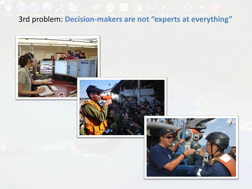
8 3rd problem: Decision-makers are not experts at everything


9 Decision Support System DSS or Decision Support System is a system that provides complete support to human decision-making process by providing all necessary information and warnings at the right time DATA MODELS INTERFACE USER


 minimizes possibility that wrong decision has been made.")
10 Wrong decisions do not affect only efficiency of the system, but consequences can be catastrophic! Consequences of right decision DSS Decision Support System (DSS) minimizes possibility that wrong decision has been made. Consequences of wrong decision
 minimizes possibility that wrong decision has been made.")
")
11 Taking into account the rapid development of Internet technology and the need for multi-user application (multi-agency model), further development of DSS has pointed to the need of transition from Desktop application to... Web application Web-based Decision Support for Incident Situation in the Adriatic Sea (WDS-ISAS)

12 Web-based Decision Support for Incident Situation in the Adriatic Sea (WDS-ISAS) WDS-ISAS is Microsoft Silverlight application based on ESRI ArcGIS Silverlight API and ArcGIS Server 10.1 WDS-ISAS is a true web mashup application, it combines many different data types from different sources Main features are: Rich GIS database on Adriatic sea Ship positioning tool Multi-Criteria Analysis tool for selection of optimal place of refugee GeoGate tool for geo-referencing of images and videos Sea Forecasting data, etc.


 ESRI Map Services ESRI Geoprocessing Services GML File Forecasting data")
13 WDS-ISAS combines all relevant data (different type from different sources) DGU layers Web Map Service Radar data Web application WDS-ISAS TXT File AIS data ADRIA-GIS data (Hydrographic Institute of the Republic of Croatia) IZOR data (Institute of Oceanography and Fisheries) ESRI Map Services ESRI Geoprocessing Services GML File Forecasting data GIF Image
 ESRI Map Services ESRI Geoprocessing Services GML File Forecasting data")
14 WDS-ISAS: live feed of vessels position using AIS data from web services and nautical charts

15 WDS-ISAS: selection of optimal place of refugee for ship in distress using Multi-Criteria Analysis module

16 WDS-ISAS: spatial search for important ecological and emergency data around ship position

17 WDS-ISAS: import of results from oil-spill prediction model GNOME using GeoGate module

18 Improving oil-spill prediction model In order to improve oil-spill predicting, a collaboration has been established with Applied Science Associates (ASA) and some experiments have been made using their OilMapWeb application

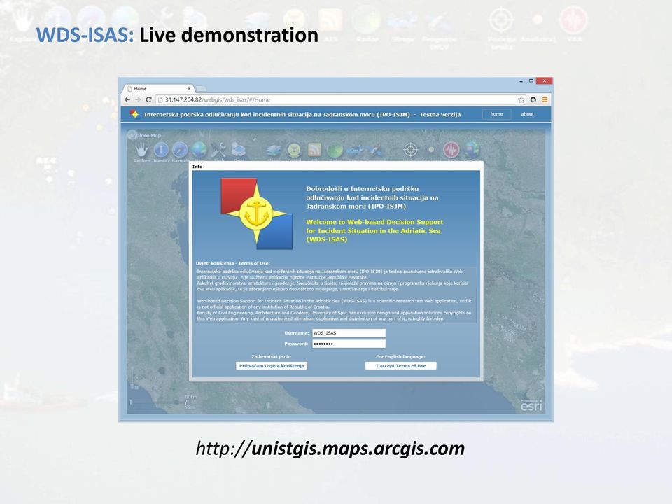
19 WDS-ISAS: Live demonstration
20 Acknowledgments Web-based Decision Support for Incident Situation in the Adriatic Sea (WDS-ISAS) is still under development and evaluation by University of Split in collaboration with Coast Guard of the Republic of Croatia

21 Contact: Prof. Nenad Mladineo, Ph.D. University of Split, Faculty of Civil Engineering, Architecture and Geodesy
Project management in mine actions using Multi-Criteria- Analysis-based decision support system
 Croatian Operational Research Review 415 CRORR 5(2014), 415 425 Project management in mine actions using Multi-Criteria- Analysis-based decision support system Marko Mladineo 1,, Nenad Mladineo 2 and Nikša
About As. In a team with the best. ESRI Bulgaria is the exclusive distributor of Esri Inc. for Bulgaria. Esri Inc.
 About As ESRI Bulgaria is an IT company, leader in the field of Geographic Information Systems (GIS) on the Bulgarian market. Offering the most advanced high-tech products, solutions and services, ESRI
Management of Marine Environment ENVS 590. Instructor Dr. Assad A. Al-Thukair
 Management of Marine Environment ENVS 590 Instructor Dr. Assad A. Al-Thukair Contingency Planning Background Elements of Contingency Planning Information gathering Strategy development Operational plan
Managing Bathymetry in the Cloud with GIS
 Esri Maritime Professional Services GEBCO Science Day Tuesday, October 4, 2011 Managing Bathymetry in the Cloud with GIS Timothy Kearns & Beata Van Esch Overview The challenges of bathymetry in GIS - What
Analysing Big Data in ArcGIS
 OIL & GAS Analysing Big Data in ArcGIS AIS based risk modelling Esri European Petroleum GIS Conference 2014 Karl John Pedersen 7th November 2014 1 DNV GL 2014 7th November 2014 SAFER, SMARTER, GREENER
A Contribution to the Analysis of Maritime Accidents with Catastrophic Consequence
 A Contribution to the Analysis of Maritime Accidents with Catastrophic Consequence Lusic Zvonimir M. Sc., Erceg Tonci Faculty of Maritime Studies Split, Croatia Zrinsko-Frankopanska 38, 21000 Split Phone:
Maritime Domain Management System
 Maritime Domain Management System A member of the SRT plc group www.srt-marinesystems.com 1 Who is SRT Marine System Solutions? The global leaders in maritime domain VTS, VMS technologies, products and
Maritime Safety and Security
 Maritime Safety and Security - A Priority Area of the EU Strategy for the Baltic Sea Region Actions and activities in the Baltic Sea Region to secure a leading role in maritime safety and security The
Off The Shelf Approach to ArcGIS Server & The Dashboard Approach to Gaining Insight to ArcGIS Server
 Off The Shelf Approach to ArcGIS Server & The Dashboard Approach to Gaining Insight to ArcGIS Server Robert Lenarcic Latitude Geographics [email protected] AGENDA Out of the box ArcGIS Server web-mapping
U.S. Coast Guard. America s Maritime Guardian
 U.S. Coast Guard America s Maritime Guardian Nov. 2009 A few armed vessels, judiciously stationed at the entrances of our ports, might at a small expense be made useful sentinels of the laws. Alexander
MEDITERRANEAN AND BLACK SEAS HYDROGRAPHIC COMMISSION XVIII CONFERENCE
 MEDITERRANEAN AND BLACK SEAS HYDROGRAPHIC COMMISSION XVIII CONFERENCE CONTRIBUTION BY MONTENEGRO INSTITUTE OF HYDROMETEOROLOGY AND SEISMOLOGY SECTOR FOR HYDROGRAPHY AND OCEANOGRAPHY TURKEY, Istanbul 25-27
A method for assessing the risk of sea transportation: Numerical examples for the Oslofjord
 A method for assessing the risk of sea transportation: Numerical examples for the Oslofjord Håvard J. Thevik*, Eirik Sørgård, and Tim Fowler * Veritasveien 1, N-1322 Høvik, Norway. [email protected]
E-navigation, process, results, status and delivery
 E-navigation, process, results, status and delivery Chile, October 2013 John Erik Hagen, Regional Director NCA Coordinator of IMO Correspondence Group on e-navigation Shipping moves into the digital world
The Nationwide Automatic Identification System Newsletter Issue #1 3 rd Quarter FY 2007
 June 2007 Issue 1 The Nationwide Automatic Identification System Newsletter Issue #1 3 rd Quarter FY 2007 W elcome to the first issue of The Guardian, a quarterly newsletter issued by the Nationwide Automatic
THE IMPROVEMENT OF WINTER NAVIGATION WITH RISK-BASED APPROACHES Tapio Nyman VTT Industrial Systems [email protected]
 THE IMPROVEMENT OF WINTER NAVIGATION WITH RISK-BASED APPROACHES Tapio Nyman VTT Industrial Systems [email protected] ICE DAY Basics of Winter Navigation in the Baltic Sea 11th and 12th February, 2004
ON JANUARY 7TH, 2012, THE COSTA CONCORDIA DEPARTED FROM THE PORT OF SAVONA TO
 ON JANUARY 7TH, 2012, THE COSTA CONCORDIA DEPARTED FROM THE PORT OF SAVONA TO BEGIN AN 8 DAY CRUISE IN THE MEDITERRANEAN SEA WITH EXPECTED RETURN IN SAVONA ON JANUARY 14TH. ON JANUARY 13TH AT 20:18 LOCAL
Maritime Domain Awareness: Mapping, Tracking, and Visualization
 Maritime Domain Awareness: Mapping, Tracking, and Visualization Authorized Distributor for: COM DEV USA and exactearth Ltd Proprietary What is Maritime Domain Awareness? Maritime Domain: All areas and
Assessment and preparedness to potential pollution scenarios within the Mediterranean basin in upstream and shipping operations
 Assessment and preparedness to potential pollution scenarios within the Mediterranean basin in upstream and shipping operations Francesca POLLA MATTIOT HSEQ Major Emergencies Rome, May 18 th 2011 eni overview
REPUBLIC OF CROATIA MINISTRY OF TOURISM
 REPUBLIC OF CROATIA MINISTRY OF TOURISM NAUTICA New legal regulations Sojourn Tax Act (Official Gazette 152/08 and 59/09 corrigendum) - Frequently asked questions - General 1. What are the advantages of
GREENLAND COMMAND. Rear Admiral Henrik Kudsk
 GREENLAND COMMAND Rear Admiral Henrik Kudsk Maritime Safety in the Arctic factors, capabilities new challenges. Agenda: Greenland Greenland Command. The Search and Rescue task. Resources for Search and
POLLUTION DAMAGE LIABILITY AND COMPENSATION ISSUES RELATED TO OFFSHORE ACTIVITIES
 POLLUTION DAMAGE LIABILITY AND COMPENSATION ISSUES RELATED TO OFFSHORE ACTIVITIES Valdas Langas [email protected] Coastal Research ad Planning Institute, Klaipėda University Palanga, December 2-3, 2010
KOTKA VTS MASTER'S GUIDE
 1 (5) KOTKA VTS MASTER'S GUIDE Vessel Traffic Services The provisions on vessel traffic services are laid down in the Vessel Traffic Service Act 623/2005 and in the Government Decree on Vessel Traffic
Curriculum for the Degree of. Bachelor of Science. Nautical Science
 Curriculum for the Degree of Bachelor of Science In Nautical Science 1 1.Name :Bachelor of Science ( Nautical Science ) Abbreviation : B.Sc.( Nautical Science ) 2.Program of Study The Bachelor of Nautical
Harbourmaster s Office Operation of Emergency Response Vessels within the Auckland Region. Navigation Safety Operating Requirements 2014
 Harbourmaster s Office Operation of Emergency Response Vessels within the Auckland Region Navigation Safety Operating Requirements 2014 Auckland Council Harbourmaster s Office Operation of Emergency Response
CONCEPT FOR ACTIVITY 1: DYNAMIC & PROACTIVE ROUTES OR GREEN-ROUTES
 TEN-T PROJECT NO: 2010-EU-21109-S CONCEPT FOR ACTIVITY 1: DYNAMIC & PROACTIVE ROUTES OR GREEN-ROUTES January 2012 TABLE OF CONTENTS 1 INTRODUCTION... 3 1.1 Scope and purpose... 3 1.2 Objectives and expected
Pollution Response RESPONDING TO AN OIL SPILL
 Pollution Response RESPONDING TO AN OIL SPILL Most oil spills within New Zealand waters are likely to happen close to the coast or in harbours. This makes it extremely difficult for responders to prevent
Security Systems EMERGENCY MANAGEMENT. In security you cannot choose the second best option. indracompany.com
 Security Systems EMERGENCY MANAGEMENT In security you cannot choose the second best option indracompany.com EMERGENCY MANAGEMENT EMERGENCY MANAGEMENT EMERGENCY C4i CENTRE Crisis management and preparednesss
GIS Management of NYC's Waterfront Infrastructure. Presented By: Stephen A. Famularo, P.E. Ocean and Coastal Consultants, Inc.
 GIS Management of NYC's Waterfront Infrastructure Presented By: Stephen A. Famularo, P.E. Ocean and Coastal Consultants, Inc. March 3, 2009 Coastal Geotools 2009 Presentation Outline Introduction Project
OPERATIONS DASHBOARD A PILOT PROJECT FOR SECURITY OPERATIONS SCAUG 2014
 OPERATIONS DASHBOARD A PILOT PROJECT FOR SECURITY OPERATIONS SCAUG 2014 ABOUT ACCESS THE NEED Access Midstream Corporate Security 24/7 Security Operations Center Tasked with ensuring employee, contractor
Chapter 1: Introduction to ArcGIS Server
 Chapter 1: Introduction to ArcGIS Server At a high level you can think of ArcGIS Server as software that helps you take your geographic information and make it available to others. This data can be distributed
Maritime accidents and safety investigations. Executive Director Dr. Veli-Pekka Nurmi
 Maritime accidents and safety investigations Executive Director Background for marine accident investigations Historically the maritime safety has improved through learning by experience. The practises
Law on Coast Guard. Art 1 Purpose. The purpose of this law is to reestablish a Coast Guard for Somalia. Art 2 Definitions
 Law No------/2015 Law on Coast Guard Art 1 Purpose The purpose of this law is to reestablish a Coast Guard for Somalia. For the purpose of this Law:. means. Art 2 Definitions Art 3 Applicability of Somali
Statistical Review of the Annual Report on the Performance of Maritime Safety Inspection in Croatia
 Statistical Review of the Annual Report on the Performance of Maritime Safety Inspection in Croatia Tatjana Stanivuk a, Boris Medić a, Marta Medić b This paper provides a detailed analysis of the annual
Implementing an Imagery Management System at Mexican Navy
 Implementing an Imagery Management System at Mexican Navy The Mexican Navy safeguards 11,000 kilometers of Mexican coastlines, inland water bodies suitable for navigation, and the territorial sea and maritime
Baltic Sea Perspective on - Building a Gas Pipeline and - Oil Spills
 Baltic Sea Perspective on - Building a Gas Pipeline and - Oil Spills Dr Juha-Markku Leppänen Head of the Monitoring and Assessment Unit, Marine Research Centre, Finnish Environment Institute (SYKE) Content
e-navigation and Geospatial Intelligence for Maritime Operations; Developing a Strategic Vision Digital Ship Athens 2014
 e-navigation and Geospatial Intelligence for Maritime Operations; Developing a Strategic Vision Digital Ship Athens 2014 Michael Rambaut for John Erik Hagen, Regional Director NCA Coordinator of IMO Correspondence
Five Steps to Better Performance
 Effective Web maps have a specific focus and are designed so users can interact with them to accomplish meaningful tasks. Five Steps to Better Performance Sample methodology for creating a great Web map
METIER Course No. 6: Remote Sensing & Hydrosphere Helsinki 6 November 2008 Kati Tahvonen Finnish Environment Institute
 The Use of Remote Sensing, Drifting Forecasts and GIS Data in Oil Response and Pollution Monitoring METIER Course No. 6: Remote Sensing & Hydrosphere Helsinki 6 November 2008 Kati Tahvonen Finnish Environment
DEVELOPMENT STRATEGY FOR INLAND WATERWAY TRANSPORT IN THE REPUBLIC OF CROATIA (2008-2018)
") REPUBLIC OF CROATIA MINISTRY OF THE SEA, TRANSPORT AND INFRASTRUCTURE DEVELOPMENT STRATEGY FOR INLAND WATERWAY TRANSPORT IN THE REPUBLIC OF CROATIA (2008-2018) April, 2008 Contents page 1 Introduction.
REPUBLIC OF CROATIA MINISTRY OF THE SEA, TRANSPORT AND INFRASTRUCTURE DEVELOPMENT STRATEGY FOR INLAND WATERWAY TRANSPORT IN THE REPUBLIC OF CROATIA (2008-2018) April, 2008 Contents page 1 Introduction.
Horn of Africa: Threat Factors for Commercial Shipping and Forecast of Pirate Activity Through 2009
 Horn of Africa: Threat Factors for Commercial Shipping and Forecast of Pirate Activity Through 2009 Scope Note This assessment of factors affecting pirate success and the ability of commercial vessels
 Enclosure (1) to NVIC 01-16 Use of official electronic charts, electronic charting systems and electronic publications This guidance applies to vessels subject to U.S. chart (or map) and publication carriage
Hydrography at IHO cat A level: Scientific Education, at Sea Training, and Interaction with the Industry. N. Debese, R. Moitié, N.
 Hydrography at IHO cat A level: Scientific Education, at Sea Training, and Interaction with the Industry N. Debese, R. Moitié, N. Seube analysis CHC 2010-2 Located in Brest: takes benefits of the French
Implementing ArcGIS for SharePoint Habitat for Humanity of Omaha April, 2013
 Ingenuity Innovation Integrity Implementing ArcGIS for SharePoint Habitat for Humanity of Omaha April, 2013 1851 Alexander Bell Drive Suite 350 Reston, VA 20191 703.463.2059 800.483.2434 www.vistronix.com
THE IMPLEMENTATION OF THE NAIROBI INTERNATIONAL CONVENTION ON REMOVAL OF WRECKS, 2007 IN THE CROATIAN LAW
 THE IMPLEMENTATION OF THE NAIROBI INTERNATIONAL CONVENTION ON REMOVAL OF WRECKS, 2007 Axel Luttenberger, Ph.D. Biserka Rukavina, Ph.D. Loris Rak University of Rijeka Faculty of Maritime Studies Rijeka
A Geographic Information Systems (GIS) Hazard Assessment Application for Recreational Diving within Lake Superior Shipwrecks
 Hazard Assessment Application for Recreational Diving within Lake Superior Shipwrecks") A Geographic Information Systems (GIS) Hazard Assessment Application for Recreational Diving within Lake Superior Shipwrecks Nathan Graham Department of Resource Analysis, Saint Mary s University of Minnesota,
A Geographic Information Systems (GIS) Hazard Assessment Application for Recreational Diving within Lake Superior Shipwrecks Nathan Graham Department of Resource Analysis, Saint Mary s University of Minnesota,
DEPARTMENT OF MARINE SERVICES AND MERCHANT SHIPPING (ADOMS) Boatmaster s Licenses
 Boatmaster s Licenses") CIRCULAR Local 2013-001 DEPARTMENT OF MARINE SERVICES AND MERCHANT SHIPPING (ADOMS) Boatmaster s Licenses Ref SCV Code. Companies operating SCV certificated vessels under the flag of Antigua and Barbuda.
CIRCULAR Local 2013-001 DEPARTMENT OF MARINE SERVICES AND MERCHANT SHIPPING (ADOMS) Boatmaster s Licenses Ref SCV Code. Companies operating SCV certificated vessels under the flag of Antigua and Barbuda.
An exactearth Technical White Paper April 2015. Satellite AIS
 An exactearth Technical White Paper April 2015 Satellite AIS Executive Summary exactearth Ltd (www.exactearth.com) is a private data services company delivering global locationbased maritime vessel tracking
Safety Management System (SMS) Guidelines
 Guidelines") Safety Management System (SMS) Guidelines What is an SMS? An SMS is a tool used to help keep people, vessels and the environment safe. It encourages the development of a safety culture where safety becomes
Safety Management System (SMS) Guidelines What is an SMS? An SMS is a tool used to help keep people, vessels and the environment safe. It encourages the development of a safety culture where safety becomes
Oil Spill Preparedness and Response: The Singapore Experience
 Oil Spill and : The Singapore Experience Capt M Segar Assistant Chief Executive (Operations) Maritime and Port Authority of Singapore Scope Introduction MPA s Strategy in Combating Oil Spill Regional Cooperation
Natural Resource Damage Assessment and Restoration
 Natural Resource Damage Assessment and Restoration Sarah Allan NOAA Office of Response and Restoration Anchorage, AK [email protected] NOAA OR&R United States Department of Commerce National Oceanic
OPRC Level II CONTINGENCY PLANNING, RESPONSE MANAGEMENT AND ORGANIZATION
 OPRC Level II CONTINGENCY PLANNING, RESPONSE MANAGEMENT AND ORGANIZATION Outline 1. Purpose and types of plans 2. Structure of a contingency plan 3. The response organization 4. Escalation of the response
I. CROATIA I.1. COUNTRY CHARACTERISTICS. Country reports
 Country reports I. CROATIA Disclaimer This document has not been adopted by the European Commission and should therefore not be relied upon as a statement of the European Commission. The purpose of this
Audit of Port Marine Safety Code compliance
 DUCHY OF CORNWALL ST MARY S HARBOUR Audit of Port Marine Safety Code compliance October 15 Marine Safety Management System by sections 1. POLICY Policy Development and Communication Approved by the Board
 CONTENTS TRAFFIC ACCIDENTS AND SAFETY POLICIES INTRODUCTION 1. Traffic Accidents in General 1 2. Promotion of Traffic Safety and Accident Trends 3 3. The Future Direction of Traffic Safety Measures 6 BOOK
REGULATION on the Maritime Traffic Service and vessel traffic monitoring and information system.
 REGULATION on the Maritime Traffic Service and vessel traffic monitoring and information system. CHAPTER I General provisions Article 1 Central administration, purpose and role The Minister of Transport
Australia's approach to emergency response and towage
 9 th Asia Pacific Heads of Maritime Safety Authorities Forum Vina Del Mar, Chile, 18-21 April 2006 Australia's approach to emergency response and towage Clive Davidson Chief Executive Australian Maritime
Evaluating ship collision risks
 Evaluating ship collision risks Silveira, P., Teixeira, A.P, & Guedes Soares, C. IRIS Project risk management: Improving risk matrices using multiple criteria decision analysis Centre for Marine Technology
Capacity building for Maritime Domain Awareness in East Africa
 1 US Naval Forces Africa Capacity building for Maritime Domain Awareness in East Africa Kirsty McLean + 39 081 568 8104 +39 335 179 6404 [email protected] Overview 2 What is NAVAF and what do we
POLAR ICE Integrated Arctic and Antarctic Sea Ice monitoring Services
 VTT TECHNICAL RESEARCH CENTRE OF FINLAND LTD Place for a photo (no lines around photo) Photo: Tapio Nyman http://www.polarice.eu/ POLAR ICE Integrated Arctic and Antarctic Sea Ice monitoring Services Robin
RUSSIAN LEGISLATION AND OIL SPILL RESPONSE
 1 RUSSIAN LEGISLATION AND OIL SPILL RESPONSE Dr. G.N. Semanov, Dr. A.A.Ivanchin CNIIMF, ltd Kavalergardskaya str., 6, St.Petersburg, 191015, Russia. RUSSIA HAS NOTICEABLY INCREASED OIL TRANSPORTATION BY
Real-time Risk Assessment for Aids to Navigation Using Fuzzy-FSA on Three-Dimensional Simulation System
 http://www.transnav.eu the International Journal on Marine Navigation and Safety of Sea Transportation Volume 8 Number 2 June 2014 DOI: 10.12716/1001.08.02.04 Real-time Risk Assessment for Aids to Navigation
ArcGIS 10.1 Web Apps and APIs. John Hasthorpe & Kai Hübner
 ArcGIS 10.1 Web Apps and APIs John Hasthorpe & Kai Hübner Overview Options for leveraging ArcGIS Server using Esri s Web APIs Alternatives to the Web ADF application builder (Gone in 10.1) When and how
Masters of Safety & Security. EUCISE2020 Industry Day Brussels September 23, 2015 SIGNALIS Presentation
 Masters of Safety & Security EUCISE2020 Industry Day Brussels September 23, 2015 SIGNALIS Presentation Ability to offer an end-to-end solution C2 Software & System Integration Electronics RADARS Sonars
SIO 296 Marine GIS Winter 2015
 SIO 296 Marine GIS Winter 2015 Instructor: Office hours: Heidi Batchelor Monday 4-5, Wednesday 11:30-12:30 [email protected] MESOM 157 Appointments suggested 858 534-1732 Course Syllabus Marine GIS is
The Gulf of Maine Ocean Observing System
 The Gulf of Maine Ocean Observing System Overview of remarks 1. Purpose of GoMOOS 2. Governance : User-Driven Nonprofit 3. User Community & Applications Purpose #1. Facilitate safe and efficient marine
Safety Management System Manual Guidebook
 Safety Management System Manual Guidebook Developed by: Commandant (G-MSO-2) U.S. Coast Guard Table of Contents Chapter 1: Introduction 1 Chapter 2: Safety and Environmental Protection Policy 3 Chapter
Congratulations and Welcome USCG Flotilla 4 76, 5NR
 Congratulations and Welcome USCG Flotilla 4 76, 5NR The United States Coast Guard Auxiliary The civilian volunteer arm of the United States Coast Guard Penn s Landing Philadelphia Safe Boating Education
Removal of Wrecks Directive 2015
 Removal of Wrecks Directive 2015 Directive 01-2015 The Director of the Department of Marine Services and Merchant Shipping (ADOMS), in exercise of the powers conferred by Section 7, sub-section (3) of
The Icelandic Coast Guard. Always Prepared
 The Icelandic Coast Guard Always Prepared The Icelandic Coast Guard The Icelandic Coast Guard (ICG) has recently undergone considerable changes and renewals. As a result of extensive strategic work, the
Perspectives of the marine and maritime open access research infrastructure development in Lithuania
 Perspectives of the marine and maritime open access research infrastructure development in Lithuania Saulius Gulbinskas, Asta Raugalienė Association Baltic Valley, Klaipeda Are EU innovation and research
REHABILITATION AND EXTENSION PROJECT FOR PORT OF LOBITO
 REHABILITATION AND EXTENSION PROJECT FOR PORT OF LOBITO Advantages of Port Lobito (1) Predominant geological locations Facing the Atlantic, Port Lobito locates around 30km north to Beguela City, and it
SUMMER SCHOOL ON ADVANCES IN GIS
 SUMMER SCHOOL ON ADVANCES IN GIS Six Workshops Overview The workshop sequence at the UMD Center for Geospatial Information Science is designed to provide a comprehensive overview of current state-of-the-art
AIS (Automatic Identification System)
") AIS (Automatic Identification System) AIS are the one of the most important aids to navigation that you can have add to your navigations system. It is an excellent tool for collision avoidance. In the
AIS (Automatic Identification System) AIS are the one of the most important aids to navigation that you can have add to your navigations system. It is an excellent tool for collision avoidance. In the
Towards a Universal Hydrographic Data Model
 http://www.transnav.eu the International Journal on Marine Navigation and Safety of Sea Transportation Volume 7 Number 4 December 2013 DOI: 10.12716/1001.07.04.12 Towards a Universal Hydrographic Data
GUIDELINES ON THE DESIGN AND USE OF PORTABLE PILOT UNITS
 IMPA 2009 1 GUIDELINES ON THE DESIGN AND USE OF PORTABLE PILOT UNITS Prepared by IMPA With Technical Input from CIRM IMPA 2009 2 GUIDELINES ON THE DESIGN AND USE OF PORTABLE PILOT UNITS FOREWORD With the
Welcome to Esri's Software Export Control Classification Number (ECCN) Matrix
 Matrix") Welcome to Esri's Software Export Control Classification Number (ECCN) Matrix Updated September 30, 2015 This portion of the Esri web site is to provide information regarding the export control classification
Welcome to Esri's Software Export Control Classification Number (ECCN) Matrix Updated September 30, 2015 This portion of the Esri web site is to provide information regarding the export control classification
State of the Art Observations: Maritime Information Systems
 State of the Art Observations: Maritime Information Systems Global Maritime Information Sharing Symposium Baltimore, MD 14-16 SEP 2010 John Mittleman, PhD Naval Research Laboratory Washington DC Where
Statistical Summary Marine Occurrences 2013
 Statistical Summary Marine Occurrences 2013 Foreword This document provides Canadians with an annual summary of selected maritime safety data. It covers commercial vessels, which include all vessels registered
DEVELOPMENT OF A WEB-BASED GIS MANAGEMENT SYSTEM FOR AGRICULTURAL AUTHORITIES IN IRAQ
 DEVELOPMENT OF A WEB-BASED GIS MANAGEMENT SYSTEM FOR AGRICULTURAL AUTHORITIES IN IRAQ Gabriele Bonaiti, Ph.D. 1 Dave Flahive 2 Guy Fipps, Ph.D., P.E. 3 ABSTRACT A Geographic Information System (GIS) is
Sperry Marine Fleet Management Enterprise Solution
 Sperry Marine Fleet Management Enterprise Solution Performance Based Navigation (PBN) Fuel Navigator Module Alan Aitken Canadian Regional Manager Definition Fleet Management A way of managing infrastructure
Guidance on vessel traffic services (VTS) in Danish waters
 in Danish waters") Translation. Only the Danish document has legal validity. Guidance no. 9680 of 16 December 2010 issued by the Danish Maritime Authority Guidance on vessel traffic services (VTS) in Danish waters Purpose
Translation. Only the Danish document has legal validity. Guidance no. 9680 of 16 December 2010 issued by the Danish Maritime Authority Guidance on vessel traffic services (VTS) in Danish waters Purpose
Editing Strategies for Enterprise Geodatabase
 Federal GIS Conference February 9 10, 2015 Washington, DC Editing Strategies for Enterprise Geodatabase Ty Fabling Esri Solution Engineer A Complete Platform Enabling GIS Everywhere Desktop Web Device
Coordinated Operation Capability Using Scalable C2
 Coordinated Operation Capability Using Scalable C2 Authors: Hüseyin KUTLUCA, İbrahim AKSU, Arda ÜNAL MilSOFT Yazılım Teknolojileri A.Ş. Teknokent, 06800 ODTU Ankara / TURKEY [email protected] [email protected]
Cloud application for water resources modeling. Faculty of Computer Science, University Goce Delcev Shtip, Republic of Macedonia
 Cloud application for water resources modeling Assist. Prof. Dr. Blagoj Delipetrev 1, Assist. Prof. Dr. Marjan Delipetrev 2 1 Faculty of Computer Science, University Goce Delcev Shtip, Republic of Macedonia
INTEGRANDO DATOS MARINOS Y MODELOS AL SERVICIO DE LA OPERATIVA PORTUARIA: EL SISTEMA SAMPA DEL PUERTO DE ALGECIRAS
 INTEGRANDO DATOS MARINOS Y MODELOS AL SERVICIO DE LA OPERATIVA PORTUARIA: EL SISTEMA SAMPA DEL PUERTO DE ALGECIRAS Operational Oceanography on the Strait of Gibraltar SAMPA and TRADE Teams Physical environment