The Gulf of Maine Ocean Observing System
|
|
|
- Charleen Tucker
- 10 years ago
- Views:
Transcription
1 The Gulf of Maine Ocean Observing System

2 Overview of remarks 1. Purpose of GoMOOS 2. Governance : User-Driven Nonprofit 3. User Community & Applications

3 Purpose #1. Facilitate safe and efficient marine operations, ensure national security, ensure sustainable food supply, manage ecosystems, mitigate natural hazards, ensure public health.

4 #2 To provide data and information that serve public and private sector needs to: Solve practical problems, Predict events, Increase public awareness, Further understand natural systems A Coastal Oceanic Analog of the National Weather Service.

5 GoMOOS is Regional and Multisector Serving all Gulf of Maine states and provinces: Nova Scotia, New Brunswick, Maine, New Hampshire, Massachusetts, on south Partners: Research Institutions Government Agencies Educational Institutions Private Industry Nonprofits

6 Technical Program Real-time monitoring: Weather -- surface winds, air temperature, visibility(fog), light flux, cloud conditions Oceanic conditions -- currents, waves, temperature, salinity Environmental quality dissolved oxygen, water clarity, turbidity, nutrients Ocean biology -- spectral irradiance, algal biomass, productivity, community structure, passive acoustics (whales) Modeling & Prediction: circulation & waves
 Modeling & Prediction: circulation")
7 GoMOOS Buoys (9 Active)

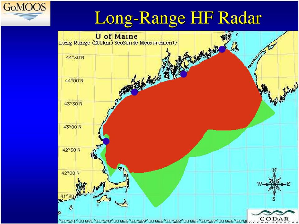
8 Long-Range HF Radar
9 1. GoMOOS Overview 2. Governance : User-Driven Nonprofit 3. User Community

10 Evolution of GoMOOS Began As: Ended As: Research project to understand GoM Science/PI organizational model Researchers as primary users Utility project to facilitate research Non-profit corporate organizational model Researchers as one user group among many

11 GoMOOS Members Research/Education: Bedford Institute of Oceanography (Canada) Bigelow Laboratory for Ocean Science Bowdoin College Dalhousie University (Canada) Maine Maritime Academy Rutgers University University of Maine University of Massachusetts, Dartmouth University of New Hampshire University of Rhode Island Woods Hole Oceanographic Institution Government: Maine Dept. of Marine Resources Maine Science & Technology Foundation Maine State Planning Office Massachusetts Coastal Zone Management Massachusetts Water Resources Authority Stellwagen Bank National Marine Sanctuary Industry: Bath Iron Works James W. Sewall Company Maine Lobstermen s Association Portland Pipe Line Corporation Satlantic, Inc. (Canada) Marine Operations: Atlantic Pilotage Authority (Canada) Eastport Port Authority Federal Marine Terminals (Canada) Penobscot Bay & River Pilots Assoc. Saint John Marine Pilots (Canada) Saint John Port Authority (Canada) Nonprofit: Gulf of Maine Aquarium Island Institute New England Aquarium

12 1. GoMOOS Overview 2. Governance : User-Driven Nonprofit 3. User Community

13 User Needs Mariners safety, rescue Shipping safety & efficiency Mammals endangered species assessment Aquaculture site selection & water quality Lobster fishing recruitment prediction Petroleum Industry spill response Shellfishing spat collection, site selection Military national security, operations test bed Coastal Management eutrophication Commercial & Sport Fishing stock assessments Research long-term observations, infrastructure

14 Maritime Shipping Industry 3,500 transits/yr 50 million tons 202,000 transit hrs $43 million ops. 1% time savings = $500,000/yr

15 Commercial Fishing Industry Time and safety Average value per fishing day = $4.1M I check for the official gale warnings, then go to the [GoMOOS] web site to see if the wind is actually blowing now. I can get a day s work in --Scalloper from Stonington, Me.

16 Connecting Fisheries to the Physical Environment Climate change Stock assessment -- chlorophyll/productivity -- circulation Aquaculture siting -- dissolved oxygen -- salinity -- sea surface temp. -- currents

17 Oil Spills: Contingency Planning, Julie N 180,000-gal. spill, Portland Harbor September 1996 Real-time -- Wind -- Waves -- Currents -- Predictive models Prevention, and Recovery

18 U. S. Coast Guard: 2 nd largest user of GoMOOS web site Search & Rescue 6000 missions/yr 500 saved lives 28 lives lost/yr 4% success after 2 hours, 1% increase in effectiveness = 6 more lives saved per year

19 Wastewater Management New Boston Harbor Sewage Outfall Boundary conditions for nutrients & currents Dissolved oxygen Helps meet costly monitoring requirements

20 Lessons Learned So Far 1. Useful information is critical Data Information. Path from Data to Information is not obvious. User participation in the design is indispensable. Tool development is create products is next 2. Stable funding stream is needed w/ local participation

21 Conclusions 1. GoMOOS can inspire and facilitate research. 2. Users (not hypotheses) will justify GoMOOS. 3. Users need a 24/7 operational system that provides useful, timely information and drives research. 4. GoMOOS cost/benefit: $(3/30)M/year. 5. A national OOS will only come to pass if Congress hears the same request from all regions!
22
An Intercampus Graduate School of Marine Sciences and Technology
 Session 2478 An Intercampus Graduate School of Marine Sciences and Technology Eugene E. Niemi, Jr. University of Massachusetts Lowell I. Introduction Four of the colleges that make up the University of
Volunteer Programs. Promoting Public Understanding, Support & Stewardship of the Channel Islands Marine Protected Areas
 Volunteer Programs Promoting Public Understanding, Support & Stewardship of the Channel Islands Marine Protected Areas By: Julie Bursek Channel Islands National Marine Sanctuary Channel Islands MPA Network
Regulating Offshore Renewable Energy Leasing and Development
 Regulating Offshore Renewable Energy Leasing and Development Robert P. LaBelle Acting Associate Director Offshore Energy and Minerals Management Bureau of Ocean Energy Management, Regulation and Enforcement
Real-time Ocean Forecasting Needs at NCEP National Weather Service
 Real-time Ocean Forecasting Needs at NCEP National Weather Service D.B. Rao NCEP Environmental Modeling Center December, 2005 HYCOM Annual Meeting, Miami, FL COMMERCE ENVIRONMENT STATE/LOCAL PLANNING HEALTH
National Data Buoy Center Cooperative Relations
 National Data Buoy Center Cooperative Relations Presentation For NGI Annual Conference May 23, 2012 Landry Bernard National Data Buoy Center Operational Mission To provide a real-time, end-to-end capability
Long-term Marine Monitoring in Willapa Bay. WA State Department of Ecology Marine Monitoring Program
 Long-term Marine Monitoring in Willapa Bay WA State Department of Ecology Marine Monitoring Program Ecology s Marine Waters Monitoring Program Goal: establish and maintain baseline environmental data Characterize
Marine Protected Areas POLICY
 Marine Protected Areas POLICY Canada March 1999 Published by: Canada Marine Ecosystems Conservation Branch Oceans Directorate Ottawa, ON K1A 0E6 DFO / 5870 Minister of Public Works and Government Service
Florida Institute of Oceanography
 Florida Institute of Oceanography Dr. William T. Hogarth, Interim Director, FIO & Dr. Jyotika I. Virmani, Associate Director, FIO National Water Quality Monitoring Council New Orleans, LA May 3-5, 2011
Malcolm L. Spaulding Professor Emeritus, Ocean Engineering University of Rhode Island Narragansett, RI 02881
 Malcolm L. Spaulding Professor Emeritus, Ocean Engineering University of Rhode Island Narragansett, RI 02881 USACE Coastal and Hydraulics Laboratory(CHL) Data Infrastructure Workshop January 23, 2014 Overview
The Integration of Hydrographic and Oceanographic Data in a Marine Geographic Information System U.S. Hydro 2015
 The Integration of Hydrographic and Oceanographic Data in a Marine Geographic Information System U.S. Hydro 2015 Karen Hart CARIS USA Oceanography and Hydrography Defined Oceanography: The branch of Earth
Finnish Marine Research Infrastructure FINMARI
 Finnish Marine Research Infrastructure FINMARI Lauri Laakso, Finnish Meteorological Institute Timo Tamminen, Finnish Environment Institute Finnish Meteorological Institute 1. National roadmap for key research
7.1 How and why are some eco-systems threatened with destruction?
 Topic 7: Oceans on the Edge 7.1 How and why are some eco-systems threatened with destruction? How are human activities degrading and destroying marine ecosystems on a global scale? Mangrove removal- over
Marine Safety and Pollution Prevention Laws and Enforcement Authorities
 A rather large number of existing federal, state and local laws, regulations and ordinances affect the LA/LB Harbor area. The Committee does not have the resources to systematically review them, but has
5.0 4.5 4.0 3.5 3.0 2.5 2.0 1.5 1.0 0.5 0.0 2009 2010 2011 2012 2013 Year
 Figures Wave Height (ft) 5.0 4.5 4.0 3.5 3.0 2.5 2.0 1.5 1.0 0.5 0.0 2009 2010 2011 2012 2013 Year Figure 1. Annual mean wave height (feet) at the Massachusetts Bay A buoy. The red line is the 2001-2009
DRAFT FINAL MITIGATED NEGATIVE DECLARATION Pursuant to Section 21080(c) Public Resources Code
 Public Resources Code") DRAFT FINAL MITIGATED NEGATIVE DECLARATION Pursuant to Section 21080(c) Public Resources Code To: Office of Planning & Research State Clearinghouse 1400 Tenth Street Sacramento, CA 95814 From: State Water
DRAFT FINAL MITIGATED NEGATIVE DECLARATION Pursuant to Section 21080(c) Public Resources Code To: Office of Planning & Research State Clearinghouse 1400 Tenth Street Sacramento, CA 95814 From: State Water
Gray Whales on the Move
 Gray Whales on the Move Students trace the migration route of a gray whale and discover the gray whale s natural history. Subjects Science GRADE LEVEL Grades 6 8 TIME 60 minutes OBJECTIVES Students will
The concepts developed in this standard include the following: Oceans cover about 70% of the surface of the Earth.
 Name Date Grade 5 SOL 5.6 Review Oceans Made by SOLpass - www.solpass.org [email protected] Reproduction is permitted for SOLpass subscribers only. The concepts developed in this standard include
AP ENVIRONMENTAL SCIENCE 2006 SCORING GUIDELINES. Question 4
 AP ENVIRONMENTAL SCIENCE 2006 SCORING GUIDELINES Question 4 (a) Identify the five-year period during which the greatest rate of decline in the fish harvest took place. For that five-year period, calculate
2012 Project Summary NORTHEAST RECREATIONAL BOATER SURVEY
 2012 Project Summary NORTHEAST RECREATIONAL BOATER SURVEY image courtesy of Urban Harbors Institute of UMass Boston A partnership among industry, government, and nongovernmental organizations conducted
PMEL Press Releases and NOAA News Stories FY09- FY14
 PMEL Press Releases and NOAA News Stories FY09- FY14 PMEL WIDE Oceanographer named to head NOAA s Seattle research laboratory http://www.noaanews.noaa.gov/stories2011/20111018_pmel.html CLIMATE THEME most
Baltic Sea Perspective on - Building a Gas Pipeline and - Oil Spills
 Baltic Sea Perspective on - Building a Gas Pipeline and - Oil Spills Dr Juha-Markku Leppänen Head of the Monitoring and Assessment Unit, Marine Research Centre, Finnish Environment Institute (SYKE) Content
INTEGRANDO DATOS MARINOS Y MODELOS AL SERVICIO DE LA OPERATIVA PORTUARIA: EL SISTEMA SAMPA DEL PUERTO DE ALGECIRAS
 INTEGRANDO DATOS MARINOS Y MODELOS AL SERVICIO DE LA OPERATIVA PORTUARIA: EL SISTEMA SAMPA DEL PUERTO DE ALGECIRAS Operational Oceanography on the Strait of Gibraltar SAMPA and TRADE Teams Physical environment
BMP Guidelines. Environmental Impact Assessment (EIA) report for activities related to hydrocarbon exploration and exploitation offshore Greenland
 report for activities related to hydrocarbon exploration and exploitation offshore Greenland") BMP Guidelines for preparing an Environmental Impact Assessment (EIA) report for activities related to hydrocarbon exploration and exploitation offshore Greenland Danish National Environmental Research
BMP Guidelines for preparing an Environmental Impact Assessment (EIA) report for activities related to hydrocarbon exploration and exploitation offshore Greenland Danish National Environmental Research
Synthesis of Regional IOOS Build-out Plans for the Next Decade
 Synthesis of Regional IOOS Build-out Plans for the Next Decade Prepared for the Integrated Ocean Observing System Association by Holly Price and Leslie Rosenfeld December 2012 Executive Summary The oceans,
Water Quality Modeling in Delaware s Inland Bays: Where Have We Been and Where Should We Go?
 Water Quality Modeling in Delaware s Inland Bays: Where Have We Been and Where Should We Go? Damian C. Brady University of Maine Center for the Inland Bays Science and Technical Advisory Committee March
User s Guide. Zuniga Point. Point Loma
 User s Guide Welcome to the Location File for San Diego Bay, located in the southwestern corner of the U.S. San Diego Bay has an excellent natural harbor, which has made it a busy commercial port. San
Coastal Resilience through Integrated Coastal Management. Alan T. White Indian Ocean Tsunami Warning System Program
 Coastal Resilience through Integrated Coastal Management Alan T. White Indian Ocean Tsunami Warning System Program The coastal zone:an endangered environment Overexploitation and destruction Unplanned
The distribution of marine OpenData via distributed data networks and Web APIs. The example of ERDDAP, the message broker and data mediator from NOAA
 The distribution of marine OpenData via distributed data networks and Web APIs. The example of ERDDAP, the message broker and data mediator from NOAA Dr. Conor Delaney 9 April 2014 GeoMaritime, London
Development of innovative tools for understanding marine biodiversity and assessing good environmental status: the progress of the EU project DEVOTES
 Development of innovative tools for understanding marine biodiversity and assessing good environmental status: the progress of the EU project DEVOTES Angel Borja Scientific Symposium 2015, 6-7 May, Malmö,
U.S. Coast Guard. America s Maritime Guardian
 U.S. Coast Guard America s Maritime Guardian Nov. 2009 A few armed vessels, judiciously stationed at the entrances of our ports, might at a small expense be made useful sentinels of the laws. Alexander
Lecture Slides Handout
 Distance Learning Program - Environmental Management http://courses.dce.harvard.edu/~environment/e101 Environmental Management ENVR E-101 - CRN 11925 Environmental Management course materials adapted for
Chapter 5. Other Accounts 5-1
 Chapter 5 Other Accounts 5-1 Other Discretionary Funds (Dollars in Thousands) FY 2006 FY 2007 Program Changes Total Other Discretionary Funds Coastal Zone Management Fund $0 $0 $0 $0 Fisherman's Contingency
Advancing the implementation of a National Water Quality Monitoring Network (The Network) for U.S. Coastal Waters and their Tributaries
 for U.S. Coastal Waters and their Tributaries") Advancing the implementation of a National Water Quality Monitoring Network (The Network) for U.S. Coastal Waters and their Tributaries Dr. Jan Newton, UW & Northwest Association of Networked Ocean Observing
Advancing the implementation of a National Water Quality Monitoring Network (The Network) for U.S. Coastal Waters and their Tributaries Dr. Jan Newton, UW & Northwest Association of Networked Ocean Observing
Operation Oil Spill Cleanup
 Name Class Date Inquiry Lab Operation Oil Spill Cleanup DESIGN YOUR OWN Offshore oil drilling and the use of supertankers for transporting oil pose the risk of oil spills. Oil spills can damage commercial
Ocean Dumping Act: A Summary of the Law
 Claudia Copeland Specialist in Resources and Environmental Policy December 15, 2010 Congressional Research Service CRS Report for Congress Prepared for Members and Committees of Congress 7-5700 www.crs.gov
Use Data Budgets to Manage Large Acoustic Datasets
 Use Data Budgets to Manage Large Acoustic Datasets Introduction Efforts to understand the health of the ocean have increased significantly in the recent past. These efforts involve among other things,
MPA NETWORKS MODULE 2 2.1 INTRODUCTION TO MPA NETWORKS. Advantages of Networks 2.2 TYPES OF MPA NETWORKS. Social Networks. Ecological Networks
 2.1 INTRODUCTION TO MPA NETWORKS Advantages of Networks 2.2 TYPES OF MPA NETWORKS Social Networks Ecological Networks Management-based Networks Case Study: A Regional Approach to MPA Development in West
SERVICES NATIONAL MARINE FISHERIES SERVICE FISHERIES MARKET NEWS HOME PAGES
 HOME PAGES The National Marine Fisheries Service provides information on programs and data available to the public and fishing industry via home page. Please use the following address for NMFS home page
Smithsonian Marine Science Network
 Smithsonian Office of the Under Secretary for Science Smithsonian Marine Science Network Michael A. Lang January 2010 1 2 Smithsonian Marine Science Network The Smithsonian Marine Science Network is a
NOAA Chesapeake Bay Office Biennial Report to Congress Fiscal Years 2011 2012
 NOAA Chesapeake Bay Office Biennial Report to Congress Fiscal Years 2011 2012 A Few Highlights from the Biennium 205 acres. The amount of oyster reef restoration work supported by NOAA Chesapeake Bay Office
Chapter 14 Quiz. Multiple Choice Identify the choice that best completes the statement or answers the question.
 Chapter 14 Quiz Multiple Choice Identify the choice that best completes the statement or answers the question. 1. Which of the following is NOT true regarding the Chesapeake Bay? a. it is one of many small
Saint Petersburg. Bayboro Marine Research Cluster
 Saint Petersburg Bayboro Marine Research Cluster Saint Petersburg At-a-Glance 4th Largest City in Florida (pop. 253,902) Median Age has dropped to 39 from 49 since 1970 $635 million Construction value
BIOLOGICAL MONITORING WITH THE WESTERN CANADIAN ODAS MARINE BUOY NETWORK
 BIOLOGICAL MONITORING WITH THE WESTERN CANADIAN ODAS MARINE BUOY NETWORK Jim Gower, Angelica Peña and Ann Gargett Institute of Ocean Sciences, P.O. Box 6, Sidney, BC, V8L 4B2 Tel: 2 363-68, Fax: 363-6746,
Julie Pullen, CSR Director Stevens Institute of Technology
 The Center for Secure and Resilient Maritime Commerce (CSR) A DHS National Center of Excellence for Maritime Security Research & Education Overview Julie Pullen, CSR Director Stevens Institute of Technology
Pollution Response RESPONDING TO AN OIL SPILL
 Pollution Response RESPONDING TO AN OIL SPILL Most oil spills within New Zealand waters are likely to happen close to the coast or in harbours. This makes it extremely difficult for responders to prevent
Coastal Modelling. Ângela Canas (MARETEC, IST)
") Ângela Canas (MARETEC, IST) Contents 1. Introduction (relevance of coastal modelling) 2. Creating a coastal model 3. MOHID Water Modelling System (theory and practice) Contents 3 case studies: Portuguese
Ângela Canas (MARETEC, IST) Contents 1. Introduction (relevance of coastal modelling) 2. Creating a coastal model 3. MOHID Water Modelling System (theory and practice) Contents 3 case studies: Portuguese
How do abiotic factors and physical processes impact life in the ocean?
 This website would like to remind you: Your browser (Apple Safari 7) is out of date. Update your browser for more security, comfort and the best experience on this site. Activitydevelop Ocean Abiotic Factors
Environmental Compliance Questionnaire for National Oceanic and Atmospheric Administration Federal Financial Assistance Applicants
 OMB Approval No.: 0648-0538 Environmental Compliance Questionnaire for National Oceanic and Atmospheric Administration Federal Financial Assistance Applicants Instructions The National Environmental Policy
BUSINESS PLAN NOVA SCOTIA FISHERIES AND AQUACULTURE LOAN BOARD
 BUSINESS PLAN NOVA SCOTIA FISHERIES AND AQUACULTURE LOAN BOARD TABLE OF CONTENTS Message from the Minister, Associate Deputy Minister and Board.......................3 Mission Statement...4 Corporate Mandate...4
Eric D. (Ric) Hines, PE February 2012 US Army Corps of Engineers BUILDING STRONG
 Hines, PE February 2012 US Army Corps of Engineers BUILDING STRONG") U.S. Army Corps of Engineers Disaster Response Missions, Roles & Readiness Eric D. (Ric) Hines, PE February 2012 US Army Corps of Engineers Briefing Overview USACE Background Emergency Roles and Responsibilities
U.S. Army Corps of Engineers Disaster Response Missions, Roles & Readiness Eric D. (Ric) Hines, PE February 2012 US Army Corps of Engineers Briefing Overview USACE Background Emergency Roles and Responsibilities
Integrating Environmental Optics into Multidisciplinary, Predictive Models of Ocean Dynamics
 DISTRIBUTION STATEMENT A. Approved for public release; distribution is unlimited. Integrating Environmental Optics into Multidisciplinary, Predictive Models of Ocean Dynamics John J. Cullen Department
The Norwegian ecosystem-based management plan for the Barents Sea and sea areas off the Lofoten Islands. The Barents Sea
 The Norwegian ecosystem-based management plan for the Barents Sea and sea areas off the Lofoten Islands By: Dr. Erik Olsen, Research Scientist The Barents Sea Continental shelf sea Average depth 230m Area
Update on EUMETSAT ocean colour services. Ewa J. Kwiatkowska
 Update on EUMETSAT ocean colour services Ewa J. Kwiatkowska 1 st International Ocean Colour Science meeting, 6 8 May, 2013 EUMETSAT space data provider for operational oceanography Operational data provider
Maritime Information Services of North America and Marine Exchange of Puget Sound at
 M I S N A Maritime Information Services of North America and Marine Exchange of Puget Sound at John Veentjer Executive Director, Puget Sound Marine Exchange President, Maritime Information Services of
Environmental Data Services for Delaware:
 Environmental Data Services for Delaware: Serving Emergency Responders, Planners, and Researchers Network Delaware Day November 6, 2013 Overview Operational Data Services More than just research DEOS and
THEMIS: MARINE RESOURCES MANAGEMENT SOFTWARE SUITE
 THEMIS: MARINE RESOURCES MANAGEMENT SOFTWARE SUITE THEMIS*, A COMPREHENSIVE FISHERIES MANAGEMENT SUITE THEMIS is a comprehensive data integration interface and a crucial tool for maintaining 24-hour fishing
AQUATIC ECOSYSTEMS & BIOMES
 AQUATIC ECOSYSTEMS & BIOMES A) Name three general types of aquatic ecosystems and describe the salinity for each. Give an example for each. 1) 2) 3) B) MATCHING In the space provided, write the letter
National Data Buoy Center Command Briefing For
 National Data Buoy Center Command Briefing For Marine Technology Society Oceans in Action August 21, 2014 Helmut H. Portmann, Director National Data Buoy Center To provide a real-time, end-to-end capability
Appendix A. The Marine Life Protection Act (MLPA)
") Appendix A. The Marine Life Protection Act (MLPA) THE PEOPLE OF THE STATE OF CALIFORNIA DO ENACT AS FOLLOWS: SECTION 1. Chapter 10.5 (commencing with Section 2850) is added to Division 3 of the Fish and
Appendix A. The Marine Life Protection Act (MLPA) THE PEOPLE OF THE STATE OF CALIFORNIA DO ENACT AS FOLLOWS: SECTION 1. Chapter 10.5 (commencing with Section 2850) is added to Division 3 of the Fish and
PE s Research activities and potential links to MM5. Red Ibérica MM5 Valencia 9th -10th June 2005
 PE s Research activities and potential links to MM5 Red Ibérica MM5 Valencia 9th -10th June 2005 PE and its R&D Area Puertos del Estado (PE) is a Public Institution that deals with the administration of
The USF College of Marine Science Integrated Model of Tampa Bay
 The USF College of Marine Science Integrated Model of Tampa Bay Mark E. Luther and Steven D. Meyers Ocean Modeling and Prediction Laboratory USF College of Marine Science 140 Seventh Avenue South St. Petersburg,
Right Whale. The Kids Times: Volume II, Issue 6. NOAA s National Marine Fisheries Service, Office of Protected Resources
 NOAA s National Marine Fisheries Service, Office of Protected Resources The Kids Times: Volume II, Issue 6 Right Whale Right whales have no dorsal fin on their backs. How did the right whale get its name?
Global Earth Observation Integrated Data Environment (GEO-IDE) Presentation to the Data Archiving and Access Requirements Working Group (DAARWG)
 Presentation to the Data Archiving and Access Requirements Working Group (DAARWG)") Global Earth Observation Integrated Data Environment (GEO-IDE) Presentation to the Data Archiving and Access Requirements Working Group (DAARWG) Ken McDonald Data Management Integration Architect National
Global Earth Observation Integrated Data Environment (GEO-IDE) Presentation to the Data Archiving and Access Requirements Working Group (DAARWG) Ken McDonald Data Management Integration Architect National
RECALLING Paragraph b of Article 13 of the Convention on the Protection of the Marine Environment of the Baltic Sea Area, 1974 (Helsinki Convention),
,") CONVENTION ON THE PROTECTION OF THE MARINE ENVIRONMENT OF THE BALTIC SEA AREA HELSINKI COMMISSION - Baltic Marine HELCOM 19/98 Environment Protection Commission 15/1 Annex 3 19th Meeting Helsinki, 23-27
CONVENTION ON THE PROTECTION OF THE MARINE ENVIRONMENT OF THE BALTIC SEA AREA HELSINKI COMMISSION - Baltic Marine HELCOM 19/98 Environment Protection Commission 15/1 Annex 3 19th Meeting Helsinki, 23-27
The Dauphin Island Sea Lab. Serving a Consortium of Alabama Public and Private Colleges and Universities
 The Dauphin Island Sea Lab Serving a Consortium of Alabama Public and Private Colleges and Universities Consortium Participants Alabama State University* Athens State University Auburn University* Auburn
Instrumentation for Monitoring around Marine Renewable Energy Devices
 Instrumentation for Monitoring around Marine Renewable Energy Devices 1 Introduction As marine renewable energy has developed, a set of consistent challenges has emerged following attempts to understand
NDBC s Smart Module Applications
 NDBC s Smart Module Applications National Data Buoy Center Stennis Space Center, MS. Rodney Riley INMARTECH 2014, Corvallis Oregon Smart Module History In 2008, started development to convert (dumb) analog
Annual Reprt 2007-2008
 University of South Florida College of Marine Science 140 7 th Avenue South Saint Petersburg, Florida 33701 Dr. William Hogarth, Dean The College of Marine Science is a GRADUATE RESEARCH program where
DAVID A. EBERT, PH.D. CURRICULUM VITAE
 DAVID A. EBERT, PH.D. CURRICULUM VITAE EDUCATION: Post-Doctorate, South African Museum, Cape Town, South Africa Ph.D., Ichthyology & Fisheries Sciences, Rhodes University, Grahamstown, South Africa M.A.,
Amherst County Public Schools. AP Environmental Science Curriculum Pacing Guide. College Board AP Environmental Science Site
 Amherst County Public Schools AP Environmental Science Curriculum Pacing Guide College Board AP Environmental Science Site REV: 8/12 1 st 9 weeks AP Objectives Energy Resources and Consumption A. Energy
Management of Marine Environment ENVS 590. Instructor Dr. Assad A. Al-Thukair
 Management of Marine Environment ENVS 590 Instructor Dr. Assad A. Al-Thukair Contingency Planning Background Elements of Contingency Planning Information gathering Strategy development Operational plan
THE CORAL TRIANGLE INITIATIVE (CTI) ON CORAL REEFS, FISHERIES AND FOOD SECURITY. 1st Sulu Sulawesi Sea (SSS) Conference 18-19 November 2015
 ON CORAL REEFS, FISHERIES AND FOOD SECURITY. 1st Sulu Sulawesi Sea (SSS) Conference 18-19 November 2015") THE CORAL TRIANGLE INITIATIVE (CTI) ON CORAL REEFS, FISHERIES AND FOOD SECURITY 1st Sulu Sulawesi Sea (SSS) Conference 18-19 November 2015 1 Introduction to CTI PRESENTATION OUTLINE State of the CTI Marine
THE CORAL TRIANGLE INITIATIVE (CTI) ON CORAL REEFS, FISHERIES AND FOOD SECURITY 1st Sulu Sulawesi Sea (SSS) Conference 18-19 November 2015 1 Introduction to CTI PRESENTATION OUTLINE State of the CTI Marine
New Canadian Oil Spill Technology
 New Canadian Oil Spill Technology First presented in Beijing, 2012 EST moon pool JBF moon pool JBF 5000 EST 25m Advantages of EST technology Oil is recovered via a stern opening. Bow strength is not compromised
Arctic Fibre Submarine Cable System
 Arctic Fibre Submarine Cable System Desktop Study & Cable Engineering 10 February 2012 Desktop Study: Phase 1 Scope Philosophy March 7, 2012 DTS Phase 1 Scope of Work Goal: Identify feasible marine survey
Canal Water Quality Restoration in the Florida Keys: One More Piece of the Puzzle in the Overall Restoration of South Florida
 Canal Water Quality Restoration in the Florida Keys: One More Piece of the Puzzle in the Overall Restoration of South Florida George Neugent Monroe County Commissioner Mike Forster Islamorada Village of
Module No. # 02. Impact of oil and gas industry on marine environment
 Health, Safety and Environmental Management in Petroleum and offshore Engineering Dr. Srinivasan Chandrasekaran Department of Ocean Engineering Indian Institute of Technology, Madras Module No. # 02 Lecture