GeoManitoba Spatial Data Infrastructure Update. Presented by: Jim Aberdeen Shawn Cruise
|
|
|
- Stuart Merritt
- 8 years ago
- Views:
Transcription


1 GeoManitoba Spatial Data Infrastructure Update Presented by: Jim Aberdeen Shawn Cruise
2 Organization Overview Manitoba Innovation Energy and Mines Business Transformation and Technology (BTT) Application Development and Integration (New) Application Management Services (Support) Infrastructure Management Services BTT - IT provider for the Province of Manitoba procurement, installation, maintenance, technical support, enhancement, upgrade, hardware, software and services negotiating services, licences and maintenance and support agreements for hardware and software.
3 Presentation Overview Spatial Data Infrastructure Data Architecture Map Services Performance Testing Scalable Architecture Geoportal Server

4 Project Description Overview The purpose for the Spatial Data Infrastructure (SDI) project is to design, build and implement a SDI that provides access to the provincial spatial framework, its users and its stakeholders. SDI Project has a Two-Stream Approach Management Framework SDI Core
5 Spatial Data Infrastructure
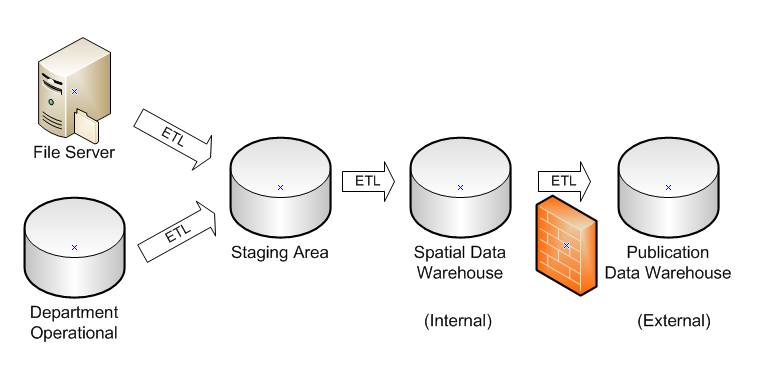
6 Data Architecture Department Operational Data maintained on the file system or preferably in an Enterprise Geodatabase Staging Area Area to review datasets before release (Internal) Spatial Data Warehouse Restricted to Internal Government consumers (External) Publication Data Warehouse Available for external consumption
7 Data Architecture
8 Map Services GIS analyst creates maps. Maps are published to ArcGIS Server as map services. Map services are delivered as web services to be consumed by many different client applications. Desktop computers Tablets Smartphones Map services can be dynamic or cached.
9 Map Services Dynamic map services read from the data store on each map request. Cached map services respond to map requests using a hierarchical set of image tiles.
10 Map Services Demo
11 Performance Testing Map service looks fine and loads fast, but how will it perform under load? Use Web Performance testing tools offered by Microsoft Visual Studio Ultimate. Define performance testing parameters How many users? What types of requests? Frequency of requests? Criteria for failure? Criteria for success?

12 Performance Testing Map service requests are URLs with parameters Bounding box parameter can be changed to request different extents Determine test area and generate random extents Group similar extents into web tests Assign a priority to each test
13 Performance Testing 50 users Half second average response time About 4 requests per second About 15 KB per map

14 Performance Testing

15 Performance Testing Slow! Fast!

16 Performance Testing Each row represents a virtual user. Length of bar is wait request time. Gaps are specified think time.

17 Performance Testing CPU utilization spikes are indicators of an inefficient map service. CPU utilization graphs should be smooth under load. Blue is number of users. Red is CPU utilization on ArcGIS Server. Orange is CPU utilization on ArcSDE.

18 Performance Testing Cause: Delay drawing large area under load Effect: Impacts otherwise fast response times Each color represents a test. X is time, Y is request service time.
19 Performance Testing Load test results suggest problems with map service as defined when displaying a larger area. ArcGIS Server and ArcSDE working too hard because of map service inefficiencies. Need to use tool like MXDPerfStat to improve map performance. Infrastructure resources must be conserved for other map services.
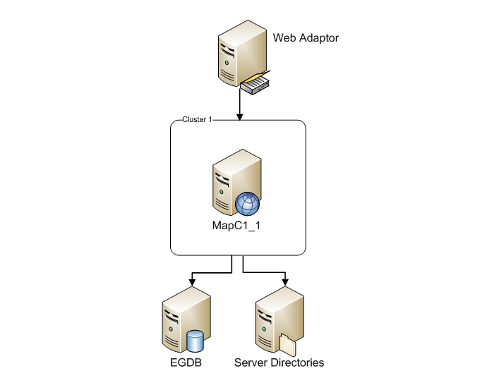
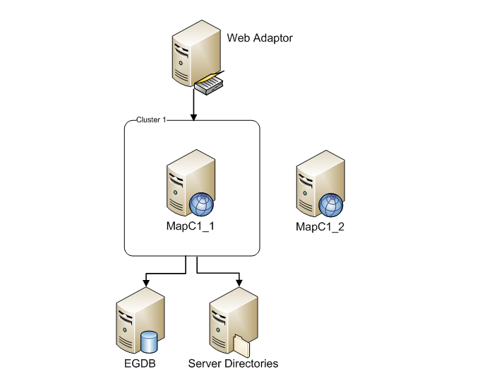
20 Scalable Architecture ArcGIS Server 10.1 is designed for scalability. Servers can be organized into groups called clusters. Infrastructure can be optimized for cluster s services. System architecture abstracts details from the end user.
21 Scalable Architecture
22 Scalable Architecture
23 Scalable Architecture
24 Scalable Architecture

25 Scalable Architecture
26
27 Esri Geoportal Server Free, open source product that enables discovery and use of geospatial resources including datasets, rasters, and Web services. With Geoportal Server you can: Reduce time and redundancy Maintain data integrity Enable easy search and discovery
28 Esri Geoportal Server Demo
29 Q & A jim.aberdeen@gov.mb.ca shawn.cruise@gov.mb.ca
ArcGIS for Server Performance and Scalability: Testing Methodologies. Andrew Sakowicz, asakowicz@esri.com Frank Pizzi, fpizzi@esri.
 ArcGIS for Server Performance and Scalability: Testing Methodologies Andrew Sakowicz, asakowicz@esri.com Frank Pizzi, fpizzi@esri.com Introductions Target audience - GIS, DB, System administrators - Testers
Enterprise GIS Solutions to GIS Data Dissemination
 Enterprise GIS Solutions to GIS Data Dissemination ESRI International User Conference July 13 17, 2009 Wendy M. Turner Senior GIS Engineer & Program Manager Freedom Consulting Group, LLC Building the Enterprise
RESPONSE TO GIS SERVICES RFP. 1. What version of ArcGIS software are you using? If it is not the latest, is there a plan to upgrade?
 RESPONSE TO GIS SERVICES RFP 1. What version of ArcGIS software are you using? If it is not the latest, is there a plan to upgrade? We are currently using ArcGIS 10.x as follows: ArcGIS for Desktop - Mixed
Manitoba Dutch Elm Disease (DED) Field Data Capture using Collector for ArcGIS and ArcGIS Online
 Field Data Capture using Collector for ArcGIS and ArcGIS Online") Manitoba Dutch Elm Disease (DED) Field Data Capture using Collector for ArcGIS and ArcGIS Online ESRI Regional User Conference Winnipeg, Manitoba April 21, 2015 1 Presentation Outline Business Problem
Manitoba Dutch Elm Disease (DED) Field Data Capture using Collector for ArcGIS and ArcGIS Online ESRI Regional User Conference Winnipeg, Manitoba April 21, 2015 1 Presentation Outline Business Problem
GIS Databases With focused on ArcSDE
 Linköpings universitet / IDA / Div. for human-centered systems GIS Databases With focused on ArcSDE Imad Abugessaisa g-imaab@ida.liu.se 20071004 1 GIS and SDBMS Geographical data is spatial data whose
Enterprise Architectures for Large Tiled Basemap Projects. Tommy Fauvell
 Enterprise Architectures for Large Tiled Basemap Projects Tommy Fauvell Tommy Fauvell Senior Technical Analyst Esri Professional Services Washington D.C Regional Office Project Technical Lead: - Responsible
ArcGIS Server Performance and Scalability Testing Methodologies. Andrew Sakowicz, Frank Pizzi
 ArcGIS Server Performance and Scalability Testing Methodologies Andrew Sakowicz, Frank Pizzi Target audience Testers Administrators (GIS, DBA, System) Developers Architects Level: Intermediate Outline
Spatial Data Infrastructure. A Collaborative Network
 Spatial Data Infrastructure A Collaborative Network Solving Challenges Takes Collaboration Social challenges, environmental issues, and economic downturns all take cooperation to solve. Working together
Chapter 1: Introduction to ArcGIS Server
 Chapter 1: Introduction to ArcGIS Server At a high level you can think of ArcGIS Server as software that helps you take your geographic information and make it available to others. This data can be distributed
An ESRI White Paper July 2009 Creating and Maintaining a Geoportal Management Considerations
 An ESRI White Paper July 2009 Creating and Maintaining a Geoportal Management Considerations ESRI 380 New York St., Redlands, CA 92373-8100 USA TEL 909-793-2853 FAX 909-793-5953 E-MAIL info@esri.com WEB
SafePeak Case Study: Large Microsoft SharePoint with SafePeak
 SafePeak Case Study: Large Microsoft SharePoint with SafePeak The benchmark was conducted in an Enterprise class organization (>2, employees), in the software development business unit, unit that widely
Choosing the right GIS framework for an informed Enterprise Web GIS Solution
 13 ANNUAL INTERNATIONAL CONFERENCE AND EXHIBITION ON GEOSPATIAL INFORMATION TECHNOLOGY AND APPLICATIONS Epicentre; Gurgaon, India; 19-21 January, 2010 Choosing the right GIS framework for an informed Enterprise
ESRI Technical Certification Overview. Amy Daniels Instructor, Greenville Tech
 ESRI Technical Certification Overview Amy Daniels Instructor, Greenville Tech Why have certification by ESRI? It communicates your proficiency in ESRI software Similar to Microsoft Certification, it can
An Esri White Paper June 2011 ArcGIS for INSPIRE
 An Esri White Paper June 2011 ArcGIS for INSPIRE Esri, 380 New York St., Redlands, CA 92373-8100 USA TEL 909-793-2853 FAX 909-793-5953 E-MAIL info@esri.com WEB esri.com Copyright 2011 Esri All rights reserved.
Deploying ArcGIS for Server Using Managed Services
 Deploying ArcGIS for Server Using Managed Services Andrew Sakowicz Erin Ross Sridhar Karra Agenda Introduction Program Overview - Overview - Methodology - Tools Customer Deployments - Architecture and
ArcGIS for Server in the Amazon Cloud. Michele Lundeen Esri
 ArcGIS for Server in the Amazon Cloud Michele Lundeen Esri What we will cover ArcGIS for Server in the Amazon Cloud Why How Extras Why do you need ArcGIS Server? Some examples Publish - Dynamic Map Services
Troubleshooting SQL Server Enterprise Geodatabase Performance Issues. Matthew Ziebarth and Ben Lin
 Troubleshooting SQL Server Enterprise Geodatabase Performance Issues Matthew Ziebarth and Ben Lin Troubleshooting SQL Server Enterprise Geodatabase Performance Issues AGENDA General configuration recommendations
ArcGIS. Server. A Complete and Integrated Server GIS
 ArcGIS Server A Complete and Integrated Server GIS ArcGIS Server A Complete and Integrated Server GIS ArcGIS Server enables you to distribute maps, models, and tools to others within your organization
ArcGIS Server Implementation HIGHS and lows
 ArcGIS Server Implementation HIGHS and lows GIS-T March 2011 Eric Abrams Iowa DOT Eric.abrams@dot.iowa.gov Agenda The Problem Timeline Future Discussion/Questions The Problem - 2006 How does Iowa DOT integrate
A Workflow for Creating and Sharing Maps
 A Workflow for Creating and Sharing Maps By Keith Mann, Esri What You Will Need Item Source ArcGIS Online for Organizations subscription ArcGIS 10.1 for Desktop (Any license level) ArcGIS Spatial Analyst
City s.R.P.A.S.R.A.R.A.R.C.A. A.C.B.B.B.A.C.B.A.C.C.A.
 CITY OF NOVI ARCGIS SERVER DEVELOPMENT & HOSTING SERVICES ADDENDUM #1 INTENT: This addendum has been issued to modify and/or interpret the original specifications for the RFP named above. Unless otherwise
Cookbook 23 September 2013 GIS Analysis Part 1 - A GIS is NOT a Map!
 Cookbook 23 September 2013 GIS Analysis Part 1 - A GIS is NOT a Map! Overview 1. A GIS is NOT a Map! 2. How does a GIS handle its data? Data Formats! GARP 0344 (Fall 2013) Page 1 Dr. Carsten Braun 1) A
FGDC, Meet the DDI. Adding Geospatial Metadata to a Numeric Data Catalog. Julie Linden Yale University
 FGDC, Meet the DDI Adding Geospatial Metadata to a Numeric Data Catalog Julie Linden Yale University Outline StatCat: numeric data catalog Why add geospatial metadata? FGDC/DDI crosswalk Implementation
Portal for ArcGIS. Satish Sankaran Robert Kircher
 Portal for ArcGIS Satish Sankaran Robert Kircher ArcGIS A Complete GIS Data Management Planning & Analysis Field Mobility Operational Awareness Constituent Engagement End to End Integration Collect, Organize,
Centre for EcologicalNoosphere Studies NAS RA CENS
 SCOPES 2009-2012 Scientific Co-operation between Eastern Europe and Switzerland Accessing Armenian Environmental data through CENS Spatial Data Infrastructure Centre for EcologicalNoosphere Studies NAS
Understanding ArcGIS Deployments in Public and Private Cloud. Marwa Mabrouk
 Understanding ArcGIS Deployments in Public and Private Cloud Marwa Mabrouk Agenda Back to Basics What are people doing? New Features Using ArcGIS in the Cloud - Private Cloud - Public Cloud Technical Demos
ArcGIS for Server: Reference Implementations Sharon Gin
 for : Reference Implementations Sharon Gin Agenda: Reference Implementations Multi-node WebGIS Federation Portal with hosting server Standalone portal Multi-node server with workload separation All in
Big Data and Analytics: Getting Started with ArcGIS. Mike Park Erik Hoel
 Big Data and Analytics: Getting Started with ArcGIS Mike Park Erik Hoel Agenda Overview of big data Distributed computation User experience Data management Big data What is it? Big Data is a loosely defined
Performance and Scalability Best Practices in ArcGIS
 2013 Europe, Middle East, and Africa User Conference October 23-25, 2013 Munich, Germany Performance and Scalability Best Practices in ArcGIS Andrew Sakowicz asakowicz@esri.com Introductions Target audience
What is ArcGIS Comprised Of?
 ArcGIS Server 9.1 What is ArcGIS Comprised Of? ArcGIS Desktop Integrated suite of GIS applications ArcGIS Engine Embeddable developer components Server GIS ArcSDE, ArcIMS, ArcGIS Server Mobile GIS ArcPad
Enterprise GIS Architecture Deployment Options. Andrew Sakowicz
 Enterprise GIS Architecture Deployment Options Andrew Sakowicz Audience Audience - Architects - Developers - Administrators - Project Managers Level: - Beginner / Intermediate Introduction Andrew Sakowicz
Lecture 8. Online GIS
 Lecture 8 Online GIS Lecture 8: Outline I. Online GIS 1. Google Earth 2. MSN Live Maps II. Open Source GIS III. ArcGIS Server and the ESRI suite of online software utility options IV. Advanced Data Mining
INCOG Transportation Planning Division Spatial Data Management Workflow GIS-T 2008
 INCOG Transportation Planning Division Spatial Data Management Workflow GIS-T 2008 Kevin Tartar, GISP Transportation Geodatabase Coordinator 201 West 5th Street, Suite 600 Tulsa, Oklahoma 74103 Phone:
INTEROPERABLE IMAGE DATA ACCESS THROUGH ARCGIS SERVER
 INTEROPERABLE IMAGE DATA ACCESS THROUGH ARCGIS SERVER Qian Liu Environmental Systems Research Institute 380 New York Street Redlands, CA92373, U.S.A - qliu@esri.com KEY WORDS: OGC, Standard, Interoperability,
Documentation of open source GIS/RS software projects
 Contract no. Workpackage Delivery Delivery Date 030776 WP1 D1.6 2007-07-02 CASCADOSS Development of a trans-national cascade training programme on Open Source GIS&RS Software for environmental applications
How To Use Arcgis For Free On A Gdb 2.2.2 (For A Gis Server) For A Small Business
 For A Small Business") Esri Middle East and Africa User Conference December 10 12 Abu Dhabi, UAE Understanding ArcGIS in Virtualization and Cloud Environments Marwa Mabrouk Powerful GIS capabilities Delivered as Web services
Esri Middle East and Africa User Conference December 10 12 Abu Dhabi, UAE Understanding ArcGIS in Virtualization and Cloud Environments Marwa Mabrouk Powerful GIS capabilities Delivered as Web services
Enterprise GIS: Designing, Testing, & Monitoring
 FedGIS Conference February 24 25, 2016 Washington, DC Enterprise GIS: Designing, Testing, & Monitoring Jim VanOstenbridge, Solution Architect jvanostenbridge@esri.com Andrew Sakowicz, Enterprise Implementation
 Mesa Community College Geographic Information Systems Technician Certificate (GISTC) Karen Blevins Faculty / GIS Program Coordinator Overview Program in brief Program development Original Program Current
Esri ArcGIS Server 10 for VMware Infrastructure
 Esri ArcGIS Server 10 for VMware Infrastructure October 2011 DEPLOYMENT AND TECHNICAL CONSIDERATIONS GUIDE Table of Contents Introduction... 3 Esri ArcGIS Server 10 Overview.... 3 VMware Infrastructure
EXPLORING AND SHARING GEOSPATIAL INFORMATION THROUGH MYGDI EXPLORER
 EXPLORING AND SHARING GEOSPATIAL INFORMATION THROUGH MYGDI EXPLORER Subashini Panchanathan Malaysian Centre For Geospatial Data Infrastructure ( MaCGDI ) Ministry of National Resources and Environment
ArcGIS Enterprise Systems: Designing, Testing and Monitoring
 Federal GIS Conference February 9 10, 2015 Washington, DC ArcGIS Enterprise Systems: Designing, Testing and Monitoring Jim VanOstenbridge, jvanostenbridge@esri.com> Martin Hamann, MHamann@esri.com Andrew
Embracing ArcGIS for Local Government. Robert Parsons Delaware County, Ohio Auditor s Office Steve Koenig Bruce Harris & Associates
 Embracing ArcGIS for Local Government Robert Parsons Delaware County, Ohio Auditor s Office Steve Koenig Bruce Harris & Associates Background Project began in April 2013 At that time ArcIMS 9.2 was the
An Esri White Paper April 2011 Esri Business Analyst Server System Design Strategies
 An Esri White Paper April 2011 Esri Business Analyst Server System Design Strategies Esri, 380 New York St., Redlands, CA 92373-8100 USA TEL 909-793-2853 FAX 909-793-5953 E-MAIL info@esri.com WEB esri.com
Implementing ArcGIS for SharePoint Habitat for Humanity of Omaha April, 2013
 Ingenuity Innovation Integrity Implementing ArcGIS for SharePoint Habitat for Humanity of Omaha April, 2013 1851 Alexander Bell Drive Suite 350 Reston, VA 20191 703.463.2059 800.483.2434 www.vistronix.com
Data Modeling Basics. John Auel GIS Technician II United Services Group
 Data Modeling Basics John Auel GIS Technician II United Services Group Background Bachelor of Science at University of Wisconsin, Steven s Point Area of Emphasis -- Cartography Been at United Services
ArcGIS Server in Practice Series: Best Practices for Creating an ArcGIS Server Web Mapping Application for Municipal/Local Government
 An Esri White Paper August 2009 ArcGIS Server in Practice Series: Esri, 380 New York St., Redlands, CA 92373-8100 USA TEL 909-793-2853 FAX 909-793-5953 E-MAIL info@esri.com WEB www.esri.com Copyright 2009
What is GIS. What is GIS? University of Tsukuba. What do you image of GIS? Copyright(C) ESRI Japan Corporation. All rights reserved.
 ESRI Japan Corporation. All rights reserved.") What is GIS University of Tsukuba Graduate School of Life and Environmental Science April 21 st, 2011 What is GIS? What do you image of GIS? Gas Insulated Switch Groupe Interventional Speciale Geographic
What is GIS University of Tsukuba Graduate School of Life and Environmental Science April 21 st, 2011 What is GIS? What do you image of GIS? Gas Insulated Switch Groupe Interventional Speciale Geographic
DATABASE ANALYST I DATABASE ANALYST II
 CITY OF ROSEVILLE DATABASE ANALYST I DATABASE ANALYST II DEFINITION To perform professional level work in designing, installing, managing, updating, and securing a variety of database systems, including
White Paper. Freeance Mobile for Cityworks
 White Paper Freeance Mobile for Cityworks Version 1.1 May 2012 Freeance Mobile for Cityworks Freeance Mobile for Cityworks 2012.1 is a mobile application for the following smartphones and tablets: iphone
Enterprise GIS: Database Planning
 John Alsup Sr. Systems Engineer Jeff DeWeese Enterprise Solutions Architect Agenda Overview Database Design Data Maintenance Infrastructure Architecture Data Distribution Learn the key planning phases
GeoCloud Project Report USGS/EROS Spatial Data Warehouse Project
 GeoCloud Project Report USGS/EROS Spatial Data Warehouse Project Description of Application The Spatial Data Warehouse project at the USGS/EROS distributes services and data in support of The National
ArcGIS Server Best Practices and Guidelines
 ArcGIS Server Best Practices and Guidelines NEARC 2007 ESRI Technical Session ESRI, Boston Agenda Components and Deployment OS User Groups and Directory Configuration Service Architectures GIS Security
HydroDesktop Overview
 HydroDesktop Overview 1. Initial Objectives HydroDesktop (formerly referred to as HIS Desktop) is a new component of the HIS project intended to address the problem of how to obtain, organize and manage
ArcGIS for Server Deployment Scenarios An ArcGIS Server s architecture tour
 ArcGIS for Server Deployment Scenarios An Arc s architecture tour Ismael Chivite Product Manager at Esri Concepts Single Machine Configurations Basic Basic with Proxy Fail-Over Load Balanced or Siloed
Making State Government IT Consolidation Work for GIS in Louisiana
 Making State Government IT Consolidation Work for GIS in Louisiana James E. Mitchell, Ph.D. Louisiana Office of Technology Services Geospatial Services Manager 2015 ESRI International Users Conference
PROJECT: ArcGIS Server Hosting
 QUOTE TO: Bridget Simpson Ohio EPA P 614.644.0043 E bridget.simpson@epa.state.oh.us angie@swova.com QUOTE DATE: June 11, 2010 QUOTE PRICE EXPIRES: 90 days from Quote Date Based on your request, Swova has
Spatial data models (types) Not taught yet
 Not taught yet") Spatial data models (types) Not taught yet A new data model in ArcGIS Geodatabase data model Use a relational database that stores geographic data A type of database in which the data is organized across
Spatial data models (types) Not taught yet A new data model in ArcGIS Geodatabase data model Use a relational database that stores geographic data A type of database in which the data is organized across
A Solution to MOP/MAOP Data Management in PODS
 2013 Esri International User Conference July 8 12, 2013 San Diego, California A Solution to MOP/MAOP Data Management in PODS Chevron Pipe Line Company Nathan Marx, GIS Project Manager Marsh Wong, IT Systems
An Esri White Paper June 2010 Tracking Server 10
 An Esri White Paper June 2010 Tracking Server 10 Esri 380 New York St., Redlands, CA 92373-8100 USA TEL 909-793-2853 FAX 909-793-5953 E-MAIL info@esri.com WEB www.esri.com Copyright 2010 Esri All rights
STATE OF NEW YORK PRICELIST August 2015 Net Price NY
 CLIN Number Esri Part Number Section Product Description Price 1 ArcGIS for Desktop Concurrent Use Licenses STATE OF NEW YORK PRICELIST August 2015 Net Price NY GIS0001 52382 ArcGIS for Desktop Advanced
LEVERAGE VBLOCK SYSTEMS FOR Esri s ArcGIS SYSTEM
 Leverage Vblock Systems for Esri's ArcGIS System Table of Contents www.vce.com LEVERAGE VBLOCK SYSTEMS FOR Esri s ArcGIS SYSTEM August 2012 1 Contents Executive summary...3 The challenge...3 The solution...3
There are various ways to find data using the Hennepin County GIS Open Data site:
 Finding Data There are various ways to find data using the Hennepin County GIS Open Data site: Type in a subject or keyword in the search bar at the top of the page and press the Enter key or click the
ArcGIS for Server Performance and Scalability-Testing and Monitoring Tools. Amr Wahba awahba@esri.com
 ArcGIS for Server Performance and Scalability-Testing and Monitoring Tools Amr Wahba awahba@esri.com Introductions Who are we? - ESRI Dubai Office Target audience - GIS administrators - DBAs - Architects
Mapping and Geographic Information Systems Professional Services
 Mapping and Geographic Information Systems Professional Services G-Cloud Services RM 1557 Service Definition Esri UK GCloud 5 Lot 4 Specialist Services Government Procurement Service Acknowledgement Esri
Attribute Data and Relational Database. Lecture 5 9/21/2006
 Attribute Data and Relational Database Lecture 5 9/21/2006 definition Attribute data is about what of a spatial data and is a list or table of data arranged as rows and columns Rows are records (map features)
Oklahoma s Open Source Spatial Data Clearinghouse: OKMaps
 Oklahoma s Open Source Spatial Data Clearinghouse: OKMaps Presented by: Mike Sharp State Geographic Information Coordinator Oklahoma Office of Geographic Information MAGIC 2014 Symposium April 28-May1,
Technical Aspects to GIS in the Cloud
 Technical Aspects to GIS in the Cloud Nathan Watermeier State GIS Coordinator State of Nebraska OCIO Michael Schonlau GIS Manager Douglas County 2013 NSGIC Annual Meeting October 30, 2013 NebraskaMAP.gov
How To Compare The Power Of An Amazon M1.Large To An Ama M1 Imap Gis Instance In A Test Plan
 White Paper for Assessing the Potential Benefits of Hosting Maryland s Basemap in the Cloud Submitted February 28, 2014 Prepared for NSDI Cooperative Agreements Program Category 7: Geospatial Platform
Institute of Natural Resources Departament of General Geology and Land use planning Work with a MAPS
 Institute of Natural Resources Departament of General Geology and Land use planning Work with a MAPS Lecturers: Berchuk V.Y. Gutareva N.Y. Contents: 1. Qgis; 2. General information; 3. Qgis desktop; 4.
ArcGIS 10.1 Geodatabase Administration. Gordon Sumerling & Christopher Brown
 ArcGIS 10.1 Geodatabase Administration Gordon Sumerling & Christopher Brown Key Improvements at ArcGIS 10.1 1. Easier Administration through Graphic Interfaces 2. Greater Seamless integration with Open
Addendum 1 RFP #154D-16F CityWorks System Cloud Hosting
 Addendum 1 CityWorks System Cloud Hosting This addendum is issued to answer questions submitted via email and to make the following revisions to this solicitation. All information provided herein is hereby
10 GEOMATICS BUSINESS SOLUTIONS - ANNUAL REPORT 2005
 10 GEOMATICS BUSINESS SOLUTIONS - ANNUAL REPORT 2005 The Planning and Economic Development Committee recommends the adoption of the recommendation contained in the following report January 30, 2006, from
Management Support of GIS. Bryan Zumwalt GIS Manager, Pinellas County, Florida Adam Carnow Account Manager, Esri
 Management Support of GIS Bryan Zumwalt GIS Manager, Pinellas County, Florida Adam Carnow Account Manager, Esri Where is Pinellas County? Overview Most Densely Populated County in Florida Plus or Minus
AV-18 Introduction of the GIS Integration
 Slide 1 AV-18 Introduction of the GIS Integration Authors Victor Lough Dan Marsillo Geoff Tarcha social.invensys.com @InvensysOpsMgmt / #SoftwareRevolution /InvensysVideos /InvensysOpsMgmt /company/invensys
INFORMATION SERVICES AZ--SM SMART ART
 AZ-SMART Arizona s Socioeconomic Modeling, Analysis and Reporting Tool Box COG/MPO Mini Conference June 22, 2007 Current Modeling Process Maricopa County Control Totals DES Demographic Model & Regional
City of Memphis Purchase of Data Migration Services
 Addendum #1 Date: June 15, 2016 TO ALL POTENTIAL BIDDERS: Science Applications International Corporation ( SAIC ) Request for Proposal (RFP) City of Memphis Purchase of Data Migration Services RFP # SAIC
Basics on Geodatabases
 Basics on Geodatabases 1 GIS Data Management 2 File and Folder System A storage system which uses the default file and folder structure found in operating systems. Uses the non-db formats we mentioned
Technology Trends In Geoinformation
 Technology Trends In Geoinformation Dato Prof. Sr Dr. Abdul Kadir Bin Taib Department of Survey and Mapping Malaysia (JUPEM) Email: drkadir@jupem.gov.my www.jupem.gov.my NGIS 2008 3 rd. National GIS Conference
Making Your Mobile Workforce More Efficient
 ArcGIS for Mobile Making Your Mobile Workforce More Efficient What Is Mobile GIS? Mobile geographic information system (GIS) technology extends GIS beyond the office and allows organizations to make accurate,
SuperGIS Server 3.2 Standard Edition Specification
 SuperGIS Server 3.2 Standard Edition Specification 20140826 Specification 1. All of the services support SOAP (Simple Object Access Protocol). 2. Use map file created by SuperGIS Desktop as map services
UNGIWG 14. Steve Maddison, George Davis, Latitude Geographics Friday, May 16 th 2014
 UNGIWG 14 Steve Maddison, George Davis, Latitude Geographics Friday, May 16 th 2014 GIS Challenges Today Spatial Application Infrastructure (SAI) The Geocortex Approach 2 1 Geocortex Essentials Web-based
Leveraging Cartegraph Data for the Management of Public Works Assets for the City of Grapevine
 Leveraging Cartegraph Data for the Management of Public Works Assets for the City of Grapevine Presented By: Suja Joseph & Julie Paine Public Works City of Grapevine Overview of Cartegraph System for the
GIS and Mapping Solutions for Developers. ESRI Developer Network (EDN SM)
") GIS and Mapping Solutions for Developers ESRI Developer Network (EDN SM) GIS and Mapping Solutions for Developers If you are a software developer looking for an effective way to bring geographic and mapping
GIS and Mapping Solutions for Developers ESRI Developer Network (EDN SM) GIS and Mapping Solutions for Developers If you are a software developer looking for an effective way to bring geographic and mapping
Task AR-09-01a Progress and Contributions
 Doug Nebert, POC U.S. Geological Survey ddnebert@usgs.gov March 2010 Task AR-09-01a Progress and Contributions Background and scope for AR-09-01a This Task defines the minimum, common technical capabilities
Developing Mapping Applications with ArcGIS Runtime SDK for Windows Mobile. Jay Chen Justin Colville
 Developing Mapping Applications with ArcGIS Runtime SDK for Windows Mobile Jay Chen Justin Colville Agenda What is ArcGIS Runtime for Windows Mobile Software Development Kit Application SDK - Introduction
Iraklis Karampourniotis, Zoi Arvanitidou, Ioannis Paraschakis. Using open source software in gis training and education
 Iraklis Karampourniotis, Zoi Arvanitidou, Ioannis Paraschakis Using open source software in gis training and education Can open source be used? The question troubling us was Can Open Source Software be
Bentley ArcGIS. Connector
 Bentley ArcGIS Connector Introduction ESRI, as a GIS software products company, and Bentley Systems, Incorporated, as a developer of solutions for architecture/engineering/construction (AEC) professionals,
ArcGIS Server Performance and Scalability Optimization and Testing. Andrew Sakowicz
 ArcGIS Server Performance and Scalability Optimization and Testing Andrew Sakowicz Objective Overview: - Key performance factors - Optimization techniques - Performance Testing Introduction Andrew Sakowicz
An ESRI White Paper October 2009 ESRI Geoportal Technology
 An ESRI White Paper October 2009 ESRI Geoportal Technology ESRI 380 New York St., Redlands, CA 92373-8100 USA TEL 909-793-2853 FAX 909-793-5953 E-MAIL info@esri.com WEB www.esri.com Copyright 2009 ESRI
ArcGIS Web Mapping. Sam Berg, esri sberg@esri.com
 ArcGIS Web Mapping Sam Berg, esri sberg@esri.com Agenda ArcGIS and WebMaps The APIs ArcGIS for Flex Viewer ArcGIS for Silverlight Builder ArcGIS for Sharepoint ArcGIS Application Templates ArcGIS Runtime
hmetrix Revolutionizing Healthcare Analytics with Vertica & Tableau
 Powered by Vertica Solution Series in conjunction with: hmetrix Revolutionizing Healthcare Analytics with Vertica & Tableau The cost of healthcare in the US continues to escalate. Consumers, employers,
MOC 20467B: Designing Business Intelligence Solutions with Microsoft SQL Server 2012
 MOC 20467B: Designing Business Intelligence Solutions with Microsoft SQL Server 2012 Course Overview This course provides students with the knowledge and skills to design business intelligence solutions
About As. In a team with the best. ESRI Bulgaria is the exclusive distributor of Esri Inc. for Bulgaria. Esri Inc.
 About As ESRI Bulgaria is an IT company, leader in the field of Geographic Information Systems (GIS) on the Bulgarian market. Offering the most advanced high-tech products, solutions and services, ESRI
Amazon Hosted ESRI GeoPortal Server. GeoCloud Project Report
 Amazon Hosted ESRI GeoPortal Server GeoCloud Project Report Description of Application Operating Organization The USDA participated in the FY 2011 Federal Geographic Data Committee (FGDC) GeoCloud Sandbox
Terry Sherman Oklahoma South Central Arc-Users Group 2014 17 th Annual Conference 9/23/2014
 Terry Sherman Oklahoma South Central Arc-Users Group 2014 17 th Annual Conference 9/23/2014 About Terry Work: Research Cyberinfrastructure Analyst for OSU High Performance Computing Center developing research
Project Title: Project PI(s) (who is doing the work; contact Project Coordinator (contact information): information):
 (who is doing the work; contact Project Coordinator (contact information): information):") Project Title: Great Northern Landscape Conservation Cooperative Geospatial Data Portal Extension: Implementing a GNLCC Spatial Toolkit and Phenology Server Project PI(s) (who is doing the work; contact
Project Title: Great Northern Landscape Conservation Cooperative Geospatial Data Portal Extension: Implementing a GNLCC Spatial Toolkit and Phenology Server Project PI(s) (who is doing the work; contact
 Advanced ArcSDE Administration for SQL Server Shannon Shields Tony Wakim Workshop Format Three topics What's New In-depth Database Administration Trouble-shooting / Performance Selection varies year to
Database Servers Tutorial
 Copyright 1995-2010 Esri All rights reserved. Table of Contents A quick tour of the database servers tutorial........................ 3 Exercise 1: Add a database server to the Catalog tree and create
Development of information management system of dams in China based on. WebGIS
 Development of information management system of dams in China based on WebGIS ZHU Xing-ming 1, GENG Qing-zhai 1,2 (1.China Institute of Water Resources and Hydropower Research, Beijing 100044, China, zhuxm@iwhr.com;
Geodatabase Programming with SQL
 DevSummit DC February 11, 2015 Washington, DC Geodatabase Programming with SQL Craig Gillgrass Assumptions Basic knowledge of SQL and relational databases Basic knowledge of the Geodatabase We ll hold