Attribute Data and Relational Database. Lecture 5 9/21/2006
|
|
|
- Crystal Reed
- 10 years ago
- Views:
Transcription
1 Attribute Data and Relational Database Lecture 5 9/21/2006

2 definition Attribute data is about what of a spatial data and is a list or table of data arranged as rows and columns Rows are records (map features) Each row represents a map feature, which has a unique label ID or object ID Columns are fields (characteristics) Intersection of a column and a row shows the values of attributes, such as color, ownership, magnitude, classification,

3 Data types of attribute data: character, integer, floating, date Each field must be defined with a data type, data width, number of decimal places The width refers to the number of space reserved for a field

4

5 examples

6 A database needed If many fields related to one record (feature-id), for example, the a soil unit can have over 80 estimated physical and chemical properties, more tables are needed to store all the attributes. A database management system (DBMS) is needed to manage multiple tables. A database is a collection of interrelated tables in digital format. There are four types: Flat file, hierarchical database, network database, relational database In GIS, we usually use relational database

7 Flat file Hierarchical Network Relational PIN: Parcel ID number Zoning (zonecode): 1-residential, 2-commercial Chang, 2004

8 Relational database A relational database is a collection of tables, also called relations, which can be connected to each other by keys. A primary key represents one or more attributes whose values can uniquely identify a record in a table. Its counterpart in another table for the purpose of linkage is called a foreign key Advantages Each table in the database can be prepared, maintained, and edited separately from other tables Efficient data management and processing, since linking tables query and/or analysis is often temporary Normalization Is steps (processes) to separate a large attribute table into small relational tables To reduce data redundancy, remove multiple values in one cells in a table, and To make efficient data storage and management possible
 to separate a large attribute table into small")
9 Normalization rules Rule 1: Fields should be Atomic; that is each piece of data should be broken down as much as possible. For example, rather than creating a field called NAME, you would create two fields : one for the first name and the other for the last name. Rules 2 and 3: Each record should contain a unique identifier so that you have a way of safely identifying the record. A Social Security Number is ideal, because no two people have the same one. The unique identifier is call a primary key. You may select one of the fields in the table as the primary key if that field would never contain duplicate values for the different records. An example of a good choice would be the social security number field. If none of the fields are suitable, the program can add a counter field that will automatically assign a unique number to each record as it is entered Rule 4: The primary key should be short, stable, and simple. Addresses and even last names may change several times during a person s life time. This is why governments and companies assign permanent identification numbers.

10 Rule 5: Every other field in the record should supply additional information about the person or thing that is uniquely identified by the primary key. For example, a table that contains data about employees may include a field that indicates the employee s supervisor s. Rule 6: Information in the table should not appear in more than one place. For example, if you tried to create a table of the different committees in an organization and had fields with name like Chairperson, Member1, Member2, and Member3, the same person could be the chair of one committee and Member1 in another. If that person changed his name, you would have to change it in more than one place. Avoid numbered field names like those shown in this example.

11 Normal(lization) forms First Normal Form Eliminate repeating groups in individual tables Create a separate table for each set of related data. Identify each set of related data with a primary key. Second Normal Form Create separate tables for sets of values that apply to multiple records Relate these tables with a foreign key. Third Normal Form Eliminate fields that do not depend on the key.

12 Example 1, Original Table Student# Advisor Adv-Room Class1 Class2 Class Jones Smith From Microsoft Knowledge Base Article

13 First Normal Form Tables Student# Advisor Adv-Room Class# 1022 Jones Jones Jones Smith Smith Smith

14 Second Normal Form Eliminate Redundant Data Students: Student# Advisor Adv-Room 1022 Jones Smith 216 Registration: Student# Class#

15 Third Normal Form Eliminate Data Not Dependant On Key Students: Registration: Student# Advisor Student# Class# 1022 Jones 4123 Smith Faculty: Name Room Jones 412 Smith

16 Example 2: normalization Multiple values in one cells, data redundancy First norm Data redundancy Chang, 2004 Second norm

17 Chang, 2004 Third norm

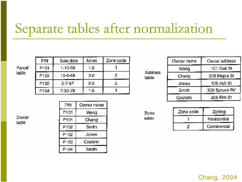
18 Separate tables after normalization Chang, 2004
19 Relationship of those separate tables One record in one table related to one record in another table One record in one table related to many records in another table Many records in one table related to one record in another table Many records in one table related to many records in another table

20 Join and relate tables Once tables are separated as relational tables, then two operations can be used to link those tables during query and analysis Join, brings together two tables based on a common key. Relate, connects two tables (based on keys) but keeps the tables separate. Keys do not have to have the same name but must be of the same data type Join relate Join relate

21 One-to-One Join Employee-id Job 1 Digislave 2 Useless Supervisor Employee-id name 1 Tom 2 John Join Employee-id to Employee-id After join Employee-id Job Name 1 Digislave Tom 2 Useless Supervisor John
22 Many-to-One Join Polygon Id Symbol 1 Qa 2 Qa 3 Pa 4 Qe Symbol Qa Qe Pa Description Quaternary Alluvium Quaternary Eolian Permian Abo Polygon ID Symbol Description 1 Qa Quaternary Alluvium 2 Qa Quaternary Alluvium 3 Pa Permian Abo 4 Qe Quaternary Eolian After Join on Symbol
23 One-to-Many Relates Symbol Mineral Formation Symbol Qa Quartz Quaternary Alluvium Permian Abo Qa Pa Pa Qa Quartz Gypsum Pa Feldspar If the tables are related on Symbol, selecting Polygon-id 1 will select the highlighted areas.
24 Many-to-Many Relates Symbol Mineral Formation Symbol Qa Quartz 1 Qa 2 Qa Pa Qa Quartz Gypsum Pa Feldspar If the tables are related on Symbol, selecting Polygon-id 1 will select the highlighted areas.
25 In ArcGIS GIS Those separate tables will have one and only one table called spatial table (or layer attribute table), which has spatial location and relationship with the spatial data. Other tables called nonspatial tables, which can be either join or relate to the spatial table. Join tables when each record in the spatial table has no more than one matching record in the nonspatial table One to one relation Many to one relation Relate tables when each record in the spatial table has more than one record in the nonspatial table One to many relation Many to many relation
26
27 The joined table The joined table will only preserved within the map document-the tables remain separate on disk-and can be removed at any time
28
29 Related tables The related table will only preserved within the map document-the tables remain separate on disk-and can be removed at any time
30 Geodatabase Before geodatabase, in one GIS project, many GIS files (spatial data and nonspatial data) are stored separated. So for a large GIS project, the GIS files could be hundreds. Within a geodatabase, all GIS files (spatial data and nonspatial data) in a project can be stored in one geodatabase, using the relational database management system (RDMS)
31 Types of geodatabases personal enterprise
32 Personal Geodatabase The personal geodatabase is given a name of filename.mdb that is browsable and editable by the ArcGIS, and it can also be opened with Microsoft Access. It can be read by multiple people at the same time, but edited by only one person at a time. maximum size is 2 GB.
33 Multiuser Geodatabase Multiuser (ArcSDE or enterprise) geodatabase are stored in IBM DB2, Informix, Oracle, or Microsoft SQL Server. It can be edited through ArcSDE by many users at the same time, is suitable for large workgroups and enterprise GIS implementations. no limit of size. support raster data.
34 3-tier ArcSDE client/server architecture with both the ArcSDE and Oracle RDBMS running on the same server, which minimizes network traffic and client load while increasing the server load compared to 2-tier system, in which the clients directly connect to the RDBMS
35 Personal and Multiuser Geodatabase Comparison source:
Spatial data models (types) Not taught yet
 Not taught yet") Spatial data models (types) Not taught yet A new data model in ArcGIS Geodatabase data model Use a relational database that stores geographic data A type of database in which the data is organized across
Spatial data models (types) Not taught yet A new data model in ArcGIS Geodatabase data model Use a relational database that stores geographic data A type of database in which the data is organized across
Basics on Geodatabases
 Basics on Geodatabases 1 GIS Data Management 2 File and Folder System A storage system which uses the default file and folder structure found in operating systems. Uses the non-db formats we mentioned
Chapter 1: Introduction to ArcGIS Server
 Chapter 1: Introduction to ArcGIS Server At a high level you can think of ArcGIS Server as software that helps you take your geographic information and make it available to others. This data can be distributed
Geodatabase Programming with SQL
 DevSummit DC February 11, 2015 Washington, DC Geodatabase Programming with SQL Craig Gillgrass Assumptions Basic knowledge of SQL and relational databases Basic knowledge of the Geodatabase We ll hold
GIS Databases With focused on ArcSDE
 Linköpings universitet / IDA / Div. for human-centered systems GIS Databases With focused on ArcSDE Imad Abugessaisa [email protected] 20071004 1 GIS and SDBMS Geographical data is spatial data whose
Topics. Database Essential Concepts. What s s a Good Database System? Using Database Software. Using Database Software. Types of Database Programs
 Topics Software V:. Database concepts: records, fields, data types. Relational and objectoriented databases. Computer maintenance and operation: storage health and utilities; back-up strategies; keeping
Cookbook 23 September 2013 GIS Analysis Part 1 - A GIS is NOT a Map!
 Cookbook 23 September 2013 GIS Analysis Part 1 - A GIS is NOT a Map! Overview 1. A GIS is NOT a Map! 2. How does a GIS handle its data? Data Formats! GARP 0344 (Fall 2013) Page 1 Dr. Carsten Braun 1) A
DATABASE MANAGEMENT FILES GIS06
 DATABASE MANAGEMENT Last day we looked at spatial data structures for both vector and raster data models. When working with large amounts of data, it is important to have good procedures for managing the
Working with the Geodatabase Using SQL
 An ESRI Technical Paper February 2004 This technical paper is aimed primarily at GIS managers and data administrators who are responsible for the installation, design, and day-to-day management of a geodatabase.
Foundations of Information Management
 Foundations of Information Management - WS 2012/13 - Juniorprofessor Alexander Markowetz Bonn Aachen International Center for Information Technology (B-IT) Data & Databases Data: Simple information Database:
1. INTRODUCTION TO RDBMS
 Oracle For Beginners Page: 1 1. INTRODUCTION TO RDBMS What is DBMS? Data Models Relational database management system (RDBMS) Relational Algebra Structured query language (SQL) What Is DBMS? Data is one
TIM 50 - Business Information Systems
 TIM 50 - Business Information Systems Lecture 15 UC Santa Cruz March 1, 2015 The Database Approach to Data Management Database: Collection of related files containing records on people, places, or things.
Tutorial on Relational Database Design
 Tutorial on Relational Database Design Introduction Relational database was proposed by Edgar Codd (of IBM Research) around 1969. It has since become the dominant database model for commercial applications
White Paper. Freeance Mobile for Cityworks
 White Paper Freeance Mobile for Cityworks Version 1.1 May 2012 Freeance Mobile for Cityworks Freeance Mobile for Cityworks 2012.1 is a mobile application for the following smartphones and tablets: iphone
ISM 318: Database Systems. Objectives. Database. Dr. Hamid R. Nemati
 ISM 318: Database Systems Dr. Hamid R. Nemati Department of Information Systems Operations Management Bryan School of Business Economics Objectives Underst the basics of data databases Underst characteristics
5.5 Copyright 2011 Pearson Education, Inc. publishing as Prentice Hall. Figure 5-2
 Class Announcements TIM 50 - Business Information Systems Lecture 15 Database Assignment 2 posted Due Tuesday 5/26 UC Santa Cruz May 19, 2015 Database: Collection of related files containing records on
Welcome to the Data Analytics Toolkit PowerPoint presentation on EHR architecture and meaningful use.
 Welcome to the Data Analytics Toolkit PowerPoint presentation on EHR architecture and meaningful use. When data is collected and entered into the electronic health record, the data is ultimately stored
ArcGIS 10.1 Geodatabase Administration. Gordon Sumerling & Christopher Brown
 ArcGIS 10.1 Geodatabase Administration Gordon Sumerling & Christopher Brown Key Improvements at ArcGIS 10.1 1. Easier Administration through Graphic Interfaces 2. Greater Seamless integration with Open
UNLEASHED. The Field Calculator. By Tom Neer, EDAW, Inc.
 The Field Calculator UNLEASHED By Tom Neer, EDAW, Inc. Understanding basic programming techniques allows the GIS user greater flexibility and expands the functionality of ArcGIS. Software developers no
Government 1008: Introduction to Geographic Information Systems. LAB EXERCISE 4: Got Database?
 Government 1008: Introduction to Geographic Information Systems Objectives: Creating geodatabases Joining attribute tables Attribute and location based queries Spatial joins Creating spatial and attribute
Spatial Database Support
 Page 1 of 11 Spatial Database Support Global Mapper can import vector data from and export vector data to the following spatial databases: Esri ArcSDE Geodatabase Esri File Geodatabase Esri Personal Geodatabases
Leveraging Cartegraph Data for the Management of Public Works Assets for the City of Grapevine
 Leveraging Cartegraph Data for the Management of Public Works Assets for the City of Grapevine Presented By: Suja Joseph & Julie Paine Public Works City of Grapevine Overview of Cartegraph System for the
Databases and DBMS. What is a Database?
 Databases and DBMS Eric Lew (MSc, BSc) SeconSys Inc. Nov 2003 What is a Database? Data (singular: datum) Factual Information Database Organized body of related information Repository / storage of information
GeoManitoba Spatial Data Infrastructure Update. Presented by: Jim Aberdeen Shawn Cruise
 GeoManitoba Spatial Data Infrastructure Update Presented by: Jim Aberdeen Shawn Cruise Organization Overview Manitoba Innovation Energy and Mines Business Transformation and Technology (BTT) Application
Step 2. Open ArcMap, set Projection to State Plane NAD 83 Feet Apply
 GIS III Exercise 01 Create a Database & Map Urban Land Use Jan 2010 Student Learning Outcomes: Import table data into an MS Access database; NOTE: DOS 8.3 naming is required for files being imported into
ArcGIS. Server. A Complete and Integrated Server GIS
 ArcGIS Server A Complete and Integrated Server GIS ArcGIS Server A Complete and Integrated Server GIS ArcGIS Server enables you to distribute maps, models, and tools to others within your organization
10. Creating and Maintaining Geographic Databases. Learning objectives. Keywords and concepts. Overview. Definitions
 10. Creating and Maintaining Geographic Databases Geographic Information Systems and Science SECOND EDITION Paul A. Longley, Michael F. Goodchild, David J. Maguire, David W. Rhind 005 John Wiley and Sons,
Understanding ArcSDE. GIS by ESRI
 Understanding ArcSDE GIS by ESRI Copyright 1999 2004 ESRI All rights reserved. Printed in the United States of America. The information contained in this document is the exclusive property of ESRI. This
Enterprise GIS: Database Planning
 John Alsup Sr. Systems Engineer Jeff DeWeese Enterprise Solutions Architect Agenda Overview Database Design Data Maintenance Infrastructure Architecture Data Distribution Learn the key planning phases
Tutorial Creating a regular grid for point sampling
 This tutorial describes how to use the fishnet, clip, and optionally the buffer tools in ArcGIS 10 to generate a regularly-spaced grid of sampling points inside a polygon layer. The steps below should
www.gr8ambitionz.com
 Data Base Management Systems (DBMS) Study Material (Objective Type questions with Answers) Shared by Akhil Arora Powered by www. your A to Z competitive exam guide Database Objective type questions Q.1
DEVELOPING AND IMPLEMENTING MULTIUSER, FULLY RELATIONAL GIS DATABASE FOR DESKTOP SYSTEMS USING OPEN SOURCE TECHNOLOGIES
 Geographia Technica, Vol. 10, Issue 2, 2015, pp 59 to 65 DEVELOPING AND IMPLEMENTING MULTIUSER, FULLY RELATIONAL GIS DATABASE FOR DESKTOP SYSTEMS USING OPEN SOURCE TECHNOLOGIES Zsolt MAGYARI-SÁSKA 1 ABSTRACT:
When to consider OLAP?
 When to consider OLAP? Author: Prakash Kewalramani Organization: Evaltech, Inc. Evaltech Research Group, Data Warehousing Practice. Date: 03/10/08 Email: [email protected] Abstract: Do you need an OLAP
Agenda. What is GIS? GIS and SAP Real Examples
 Agenda What is GIS? GIS and SAP Real Examples Life Without GIS My Stuff My Paper Maps Features Three Elements of a GIS Attributes What parcels are adjacent to Main Street? Behavior Display Query Analysis
ArcGIS Data Models Practical Templates for Implementing GIS Projects
 ArcGIS Data Models Practical Templates for Implementing GIS Projects GIS Database Design According to C.J. Date (1995), database design deals with the logical representation of data in a database. The
Creating Reports Crystal Clear
 Creating Reports Crystal Clear Presented by: Robert Acosta - Senior Client Support Co-Presenter: Praveen Maturi - Support Manager Agenda Why Crystal Reports? Planning a Report Report Access ECD vs Company
CHAPTER 6 DATABASE MANAGEMENT SYSTEMS. Learning Objectives
 CHAPTER 6 DATABASE MANAGEMENT SYSTEMS Management Information Systems, 10 th edition, By Raymond McLeod, Jr. and George P. Schell 2007, Prentice Hall, Inc. 1 Learning Objectives Understand the hierarchy
Building a Spatial Database in PostgreSQL
 Building a Spatial Database in PostgreSQL David Blasby Refractions Research [email protected] http://postgis.refractions.net Introduction PostGIS is a spatial extension for PostgreSQL PostGIS aims
Archival Challenges Associated with the Esri Personal Geodatabase and File Geodatabase Formats
 Geospatial Multistate Archive and Preservation Partnership (GeoMAPP) Archival Challenges Associated with the Esri Personal Geodatabase and File Geodatabase Formats December 6, 2011 Introduction Spatial
- Suresh Khanal. http://mcqsets.com. http://www.psexam.com Microsoft Excel Short Questions and Answers 1
 - Suresh Khanal http://mcqsets.com http://www.psexam.com Microsoft Excel Short Questions and Answers 1 Microsoft Access Short Questions and Answers with Illustrations Part I Suresh Khanal Kalanki, Kathmandu
UPDATED GIS DATABASE DESIGN: Geodatabase Model
 CITY OF SUFFOLK, VIRGINIA UPDATED GIS DATABASE DESIGN: Geodatabase Model Prepared by: Michael Baker Jr., Inc. Virginia Beach, Virginia TABLE OF CONTENTS A. GEODATABASE OVERVIEW...2 B. TYPES OF GEODATABASES...3
Databases and Information Management
 Databases and Information Management Reading: Laudon & Laudon chapter 5 Additional Reading: Brien & Marakas chapter 3-4 COMP 5131 1 Outline Database Approach to Data Management Database Management Systems
Database Design and Normalization
 Database Design and Normalization 3 CHAPTER IN THIS CHAPTER The Relational Design Theory 48 46 Database Design Unleashed PART I Access applications are database applications, an obvious statement that
Prerequisites Attended the previous technical session: Understanding geodatabase editing workflows: Introduction
 Understanding Geodatabase Editing Workflows Advanced d Robert Rader & Tony Wakim ESRI Redlands Prerequisites Attended the previous technical session: Understanding geodatabase editing workflows: Introduction
EXTENDED LEARNING MODULE A
 EXTENDED LEARNING MODULE A DESIGNING DATABASES AND ENTITY- RELATIONSHIP DIAGRAMMING Student Learning Outcomes 1. Identify how databases and spreadsheets are both similar and different. 2. List and describe
CHAPTER-IV DATABASE MANAGEMENT AND ITS ENVIRONMENT
 CHAPTER-IV DATABASE MANAGEMENT AND ITS ENVIRONMENT 4.1 EVOLUTION OF DATABASE MANAGEMENT SYSTEMS The past two decades have witnessed enormous growth in the number and importance of database applications.
Enterprise GIS Solutions to GIS Data Dissemination
 Enterprise GIS Solutions to GIS Data Dissemination ESRI International User Conference July 13 17, 2009 Wendy M. Turner Senior GIS Engineer & Program Manager Freedom Consulting Group, LLC Building the Enterprise
Foundations of Business Intelligence: Databases and Information Management
 Chapter 5 Foundations of Business Intelligence: Databases and Information Management 5.1 Copyright 2011 Pearson Education, Inc. Student Learning Objectives How does a relational database organize data,
Software implementation of the geodatabase model of the Republic of Macedonia
 Software implementation of the geodatabase model of the Republic of Macedonia Blagoj Delipetrov 1, Dragan Mihajlov 2, Marjan Delipetrov 3 1,3 University Goce Delcev, 1 Faculty of Informatics, 3 Faculty
SAMPLE: DO NOT COMPLETE
 EXP: EXPERIENCE POINT PROCEDURE Use the EXP-W experience worksheets, EXP-P professional profiles and EXP-S summary sheet to document your GIS professional experience. The Experience Schedule (next page)
GEOL 452/552 - GIS for Geoscientists I. Lecture 9
 GEOL 452/552 - GIS for Geoscientists I Lecture 9 1 Review (voting) Joining tables (database joins) Tutorial ch 4: 27-33 (43-50) HW 5: ch 4, ex 1,2 (make new float field!), 4, 5, 8 & 10 Text 2 Find the
Abstract. Introduction
 Data Replication and Data Sharing Integrating Heterogeneous Spatial Databases Mark Stoakes and Katherine Irwin Professional Services, Safe Software Inc. Abstract Spatial data warehouses are becoming more
Microsoft Access Part I (Database Design Basics) ShortCourse Handout
 ShortCourse Handout") Microsoft Access Part I (Database Design Basics) ShortCourse Handout July 2004, Technology Support, Texas Tech University. ALL RIGHTS RESERVED. Members of Texas Tech University or Texas Tech Health Sciences
Microsoft Access Part I (Database Design Basics) ShortCourse Handout July 2004, Technology Support, Texas Tech University. ALL RIGHTS RESERVED. Members of Texas Tech University or Texas Tech Health Sciences
14 Databases. Source: Foundations of Computer Science Cengage Learning. Objectives After studying this chapter, the student should be able to:
 14 Databases 14.1 Source: Foundations of Computer Science Cengage Learning Objectives After studying this chapter, the student should be able to: Define a database and a database management system (DBMS)
DATABASE INTRODUCTION
 Introduction The history of database system research is one of exceptional productivity and startling economic impact. We have learnt that from the days of file-based systems there are better ways to handle
 Database design 1 The Database Design Process: Before you build the tables and other objects that will make up your system, it is important to take time to design it. A good design is the keystone to creating
Overview of Database Management Systems
 Overview of Database Management Systems Goals: DBMS basic concepts Introduce underlying managerial issues Prepare for discussion of uses of DBMS, such as OLAP and database mining 1 Overview of Database
7. Databases and Database Management Systems
 7. Databases and Database Management Systems 7.1 What is a File? A file is a collection of data or information that has a name, called the Filename. There are many different types of files: Data files
Relational Database Basics Review
 Relational Database Basics Review IT 4153 Advanced Database J.G. Zheng Spring 2012 Overview Database approach Database system Relational model Database development 2 File Processing Approaches Based on
Administering a Microsoft SQL Server 2000 Database
 Administering a Microsoft SQL Server 2000 Database Course 2072 - Five days - Instructor-led - Hands-On Introduction This course provides students with the knowledge and skills required to install, configure,
Database Management. Technology Briefing. Modern organizations are said to be drowning in data but starving for information p.
 Technology Briefing Database Management Modern organizations are said to be drowning in data but starving for information p. 509 TB3-1 Learning Objectives TB3-2 Learning Objectives TB3-3 Database Management
Designing Databases. Introduction
 Designing Databases C Introduction Businesses rely on databases for accurate, up-to-date information. Without access to mission critical data, most businesses are unable to perform their normal daily functions,
Databases in Engineering / Lab-1 (MS-Access/SQL)
") COVER PAGE Databases in Engineering / Lab-1 (MS-Access/SQL) ITU - Geomatics 2014 2015 Fall 1 Table of Contents COVER PAGE... 0 1. INTRODUCTION... 3 1.1 Fundamentals... 3 1.2 How To Create a Database File
COVER PAGE Databases in Engineering / Lab-1 (MS-Access/SQL) ITU - Geomatics 2014 2015 Fall 1 Table of Contents COVER PAGE... 0 1. INTRODUCTION... 3 1.1 Fundamentals... 3 1.2 How To Create a Database File
An Oracle White Paper May 2013. Oracle Audit Vault and Database Firewall 12.1 Sizing Best Practices
 An Oracle White Paper May 2013 Oracle Audit Vault and Database Firewall 12.1 Sizing Best Practices Introduction... 1 Component Overview... 2 Sizing Hardware Requirements... 3 Audit Vault Server Sizing...
Chapter 14: Databases and Database Management Systems
 15 th Edition Understanding Computers Today and Tomorrow Comprehensive Chapter 14: Databases and Database Management Systems Deborah Morley Charles S. Parker Copyright 2015 Cengage Learning Learning Objectives
Geodatabase Tuning and Performance. Gillian Silvertand Greg Cunningham
 Geodatabase Tuning and Performance Gillian Silvertand Greg Cunningham Introduction to the Multiuser Geodatabase Workshop outline Performance and scalability Description Design Configuration Tuning and
Analysing Big Data in ArcGIS
 OIL & GAS Analysing Big Data in ArcGIS AIS based risk modelling Esri European Petroleum GIS Conference 2014 Karl John Pedersen 7th November 2014 1 DNV GL 2014 7th November 2014 SAFER, SMARTER, GREENER
Introduction to Computing. Lectured by: Dr. Pham Tran Vu [email protected]
 Introduction to Computing Lectured by: Dr. Pham Tran Vu [email protected] Databases The Hierarchy of Data Keys and Attributes The Traditional Approach To Data Management Database A collection of
VBA and Databases (see Chapter 14 )
") VBA and Databases (see Chapter 14 ) Kipp Martin February 29, 2012 Lecture Files Files for this module: retailersql.m retailer.accdb Outline 3 Motivation Modern Database Systems SQL Bringing Data Into MATLAB/Excel
VBA and Databases (see Chapter 14 ) Kipp Martin February 29, 2012 Lecture Files Files for this module: retailersql.m retailer.accdb Outline 3 Motivation Modern Database Systems SQL Bringing Data Into MATLAB/Excel
Fundamentals of Database Design
 Fundamentals of Database Design Zornitsa Zaharieva CERN Data Management Section - Controls Group Accelerators and Beams Department /AB-CO-DM/ 23-FEB-2005 Contents : Introduction to Databases : Main Database
n Assignment 4 n Due Thursday 2/19 n Business paper draft n Due Tuesday 2/24 n Database Assignment 2 posted n Due Thursday 2/26
 Class Announcements TIM 50 - Business Information Systems Lecture 14 Instructor: John Musacchio UC Santa Cruz n Assignment 4 n Due Thursday 2/19 n Business paper draft n Due Tuesday 2/24 n Database Assignment
Terry Sherman Oklahoma South Central Arc-Users Group 2014 17 th Annual Conference 9/23/2014
 Terry Sherman Oklahoma South Central Arc-Users Group 2014 17 th Annual Conference 9/23/2014 About Terry Work: Research Cyberinfrastructure Analyst for OSU High Performance Computing Center developing research
Database Management System
 ISSN: 2349-7637 (Online) RESEARCH HUB International Multidisciplinary Research Journal Research Paper Available online at: www.rhimrj.com Database Management System Viral R. Dagli Lecturer, Computer Science
Ken Goldberg Database Lab Notes. There are three types of relationships: One-to-One (1:1) One-to-Many (1:N) Many-to-Many (M:N).
 One-to-Many (1:N) Many-to-Many (M:N).") Lab 3 Relationships in ER Diagram and Relationships in MS Access MS Access Lab 3 Summary Introduction to Relationships Why Define Relationships? Relationships in ER Diagram vs. Relationships in MS Access
Lab 3 Relationships in ER Diagram and Relationships in MS Access MS Access Lab 3 Summary Introduction to Relationships Why Define Relationships? Relationships in ER Diagram vs. Relationships in MS Access
Kingdom Of Bahrain Ministry of Works. Enterprise Asset Management System A Geocentric Approach. Presented By Hisham Y.
 Kingdom Of Bahrain Ministry of Works Enterprise Asset Management System A Geocentric Approach Presented By Hisham Y. Sater April 2012 Ministry Of Works Bahrain MOW The construction arm of the Kingdom of
INTRODUCTION TO ARCGIS SOFTWARE
 INTRODUCTION TO ARCGIS SOFTWARE I. History of Software Development a. Developer ESRI - Environmental Systems Research Institute, Inc., in 1969 as a privately held consulting firm that specialized in landuse
ArcGIS Reference Document
 Migration of GIS Data to ArcSDE Page 1 of 10 Table of Contents A Brief Summary of DEP s GIS Data Storage o The Y Drive o ArcSDE (Spatial Database) Keeping Your GIS Project Data Current o Checking Your
Database Design. Marta Jakubowska-Sobczak IT/ADC based on slides prepared by Paula Figueiredo, IT/DB
 Marta Jakubowska-Sobczak IT/ADC based on slides prepared by Paula Figueiredo, IT/DB Outline Database concepts Conceptual Design Logical Design Communicating with the RDBMS 2 Some concepts Database: an
Primavera Project Management System at WVDOT. Presented by Marshall Burgess, WVDOT Stephen Cole, Stephen Cole Consulting Jervetta Bruce, CDP, Inc.
 : Integrating GIS With Primavera Project Management System at WVDOT Presented by Marshall Burgess, WVDOT Stephen Cole, Stephen Cole Consulting Jervetta Bruce, CDP, Inc. WVDOT Geographic Information System
How To Use Arcgis For Free On A Gdb 2.2.2 (For A Gis Server) For A Small Business
 For A Small Business") Esri Middle East and Africa User Conference December 10 12 Abu Dhabi, UAE Understanding ArcGIS in Virtualization and Cloud Environments Marwa Mabrouk Powerful GIS capabilities Delivered as Web services
Esri Middle East and Africa User Conference December 10 12 Abu Dhabi, UAE Understanding ArcGIS in Virtualization and Cloud Environments Marwa Mabrouk Powerful GIS capabilities Delivered as Web services
Administering a Microsoft SQL Server 2000 Database
 Aug/12/2002 Page 1 of 5 Administering a Microsoft SQL Server 2000 Database Catalog No: RS-MOC2072 MOC Course Number: 2072 5 days Tuition: $2,070 Introduction This course provides students with the knowledge
Creating and Using Databases with Microsoft Access
 CHAPTER A Creating and Using Databases with Microsoft Access In this chapter, you will Use Access to explore a simple database Design and create a new database Create and use forms Create and use queries
DBMS Questions. 3.) For which two constraints are indexes created when the constraint is added?
 For which two constraints are indexes created when the constraint is added?") DBMS Questions 1.) Which type of file is part of the Oracle database? A.) B.) C.) D.) Control file Password file Parameter files Archived log files 2.) Which statements are use to UNLOCK the user? A.)
DBMS Questions 1.) Which type of file is part of the Oracle database? A.) B.) C.) D.) Control file Password file Parameter files Archived log files 2.) Which statements are use to UNLOCK the user? A.)
ArcSDE Spatial Data Management Roles and Responsibilities
 ArcSDE Spatial Data Management Roles and The following discussion outlines the major roles and responsibilities involved in deploying your spatial data and geographic information system (GIS) applications
INCOG Transportation Planning Division Spatial Data Management Workflow GIS-T 2008
 INCOG Transportation Planning Division Spatial Data Management Workflow GIS-T 2008 Kevin Tartar, GISP Transportation Geodatabase Coordinator 201 West 5th Street, Suite 600 Tulsa, Oklahoma 74103 Phone:
Access Part 2 - Design
 Access Part 2 - Design The Database Design Process It is important to remember that creating a database is an iterative process. After the database is created and you and others begin to use it there will
(Geo)database and Data Management
database and Data Management") (Geo)database and Data Management An introduction to the possibilities of a centralized (spatial) data storing and access as well as its data management constraints (GLOWA Volta Project) GLOWA Volta Project
(Geo)database and Data Management An introduction to the possibilities of a centralized (spatial) data storing and access as well as its data management constraints (GLOWA Volta Project) GLOWA Volta Project
CS2Bh: Current Technologies. Introduction to XML and Relational Databases. Introduction to Databases. Why databases? Why not use XML?
 CS2Bh: Current Technologies Introduction to XML and Relational Databases Spring 2005 Introduction to Databases CS2 Spring 2005 (LN5) 1 Why databases? Why not use XML? What is missing from XML: Consistency
Access Tutorial 2 Building a Database and Defining Table Relationships
 Access Tutorial 2 Building a Database and Defining Table Relationships Microsoft Office 2013 Objectives Session 2.1 Learn the guidelines for designing databases and setting field properties Create a table