GeoMarc Spatial DNA for Advanced Geospatial Data Management
|
|
|
- Jessie Kelley
- 8 years ago
- Views:
Transcription
1 GeoMarc Spatial DNA for Advanced Geospatial Data Management Dr. Alex Philp Founder and Manager November 2007

2 GCS Research Success ESRI Foundation Partner of the Year ESRI Business Partner of the Year 2006 National Visualization and Analytics Center Award ESRI New Business Partner of the Year Montana Small Business of the Year USGS National Map Partner Award Microsoft Certified ISV 2005, 2006, 2007 MSFT Research Review Committee 2004, 2005

3 GCS Research Featured Success Story in NASA Yearly Publication

4 Overview Geospatial IT Company 2002 to Present Distributed Geospatial Solutions Government and Commercial Customers\Research Partners US Intelligence Community, US Army, US Navy (NUWC), SOCOM, TSA, Guard Bureau, US CBP, DOE-INL, USGS, USFS, USFWS, NASA, Insurance, Resource Utilization, Special Projects, Northrop Grumman, GeoEye, USDA-FAS, CSC, State of Montana, Immersive Media Company. Geospatial Situational Awareness Sensor Event Messaging and Mapping SOA Implementation ArcGIS Server and Client Arrays Integrated Products and Services 320 Combined Year of GIS Expertise Smart Data Enterprise Applications

5 Product and Solution Groups GeoMarc Desktop and Server Products Windows and Linux RDBMS Distributed GIS Push Services Network GIS Solutions Group Enterprise Projects ArcObjects (AGS) and.net Web Services SOA and SaaS
 and.")
6 GeoMarc Spatial DNA Programming Embed Creating Payload in Pixels Extract Reading Payload from Pixels Enhance Improving Workflow and Utilization Exchange Sharing Geospatial Intelligence

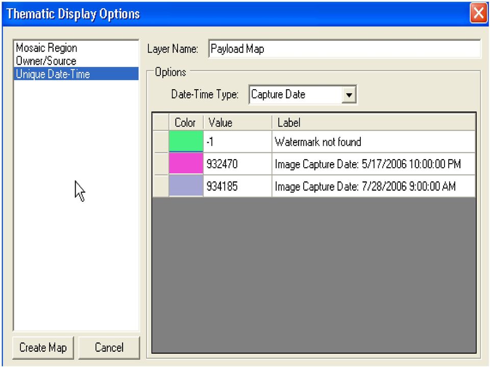
7 GeoMarc Technology Geospatial Digital Watermarking Creates unique barcode in the pixels for identification Imperceptible and measurable alteration of imagery pixels to store data Customized for spatial metadata exploitation and continuity Redundant algorithm allows retrieval even after many image alterations Rotation, scaling, compression, cropping Format changes and header loss Orthomosaic creation Distribution across Internet Inherent Functions Reliable imagery identity, linking, and tracking Associate specific users with specific pixels Easy exchange of geospatial intelligence Geospatial Applications Thematic display of barcode characteristics Time, location, ownership, permission, area of interest

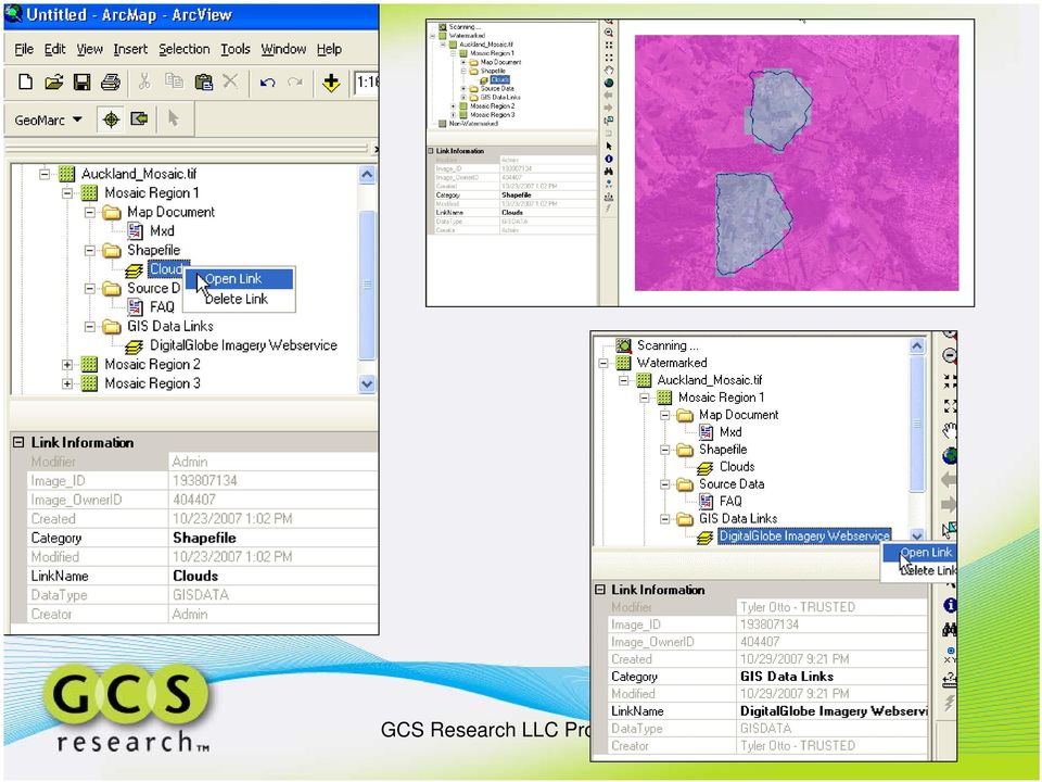
8 GeoMarc Concepts GeoMarc Payload - Barcode unique identifier: Owner ID + Image ID small redundant payload for reliable retrieval Database Registry distributed databases (local + enterprise) Push and Pull Architecture user is presented with links and can choose which data to retrieve Managed Services Embed, Extract, Enhance, and Exchange

9 GeoMarc Capabilities Barcode in the Pixels Tools to enhance Geospatial Imagery Workflows: Pixel level metadata Identifying and tracking imagery assets Linking the imagery to data and web services Distributing related information to users and colleagues Automating security and copyright rules Area of Interest Linking

10 A GeoMarc Payload Definition Payload type 4 bits Field Bits Description payload type 4 16 payload types - locked by GCS creator/source ID million source and supplier IDs - must be purchased - assigned by GCS image ID million image IDs for a single creator/source - automatically assigned by embedder time code 2 4 different meanings for the time stamp: (0=capture date - hours since 0:00 1/1/1950 GMT, 1=embed date - hours since 0:00 1/1/2000 GMT, 2= session elapsed time - seconds, 3=user defined) time stamp 24 time stamp dependent on time code above owner flags 18 See below TOTAL 96 Bits Description classification 6 64 classification types: (0=UNCLASSIFIED, 1=UNCLASSIFIED//LIMDIS, 2=SECRET//NOFORN/MR, 3=SECRET//REL TO USA, AUS, CAN and GBR//MR, remaining for future use) license 6 64 license types (0=N/A, 1=ClearView, 2=NextView, 3=DOD/Title 50, 4=DOD/Title 50/Coalition, remaining for future use) band types 3 8 band combination definitions (0=pan, 1=true color, 2=false color, 3=multi-band, 4=hyperspectral, remaining for future use) original product resolution TOTAL resolution definitions for a given source (defined by source) Creator/Source ID Im age ID Tim e code Time stamp Classification type License type Band type Resloution type 20 bits 28 bits 2 bits 24 bits 6 bits 6 bits 3 bits 3 bits
")
11

12

13
14
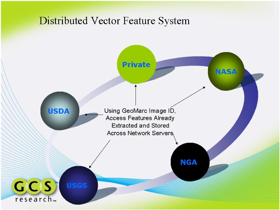
15 Problem: Raster to Vector Continuity Summary of Technical Challenge: Explosive growth in utilization and availability of geospatial raster images (as predicated); Increasing demand for automated exploitation of geospatial raster images; Multiple copies of raster data across increasingly distributed, federated geospatial workflows; Multiple feature extractions from massive image libraries; Unnecessary utilization of CPU time to conduct multiple extractions; Disconnections between parent raster image(s) and extracted vector features and loss of inherent process and attribute metadata;
 and extracted vector features and loss of inherent process and")
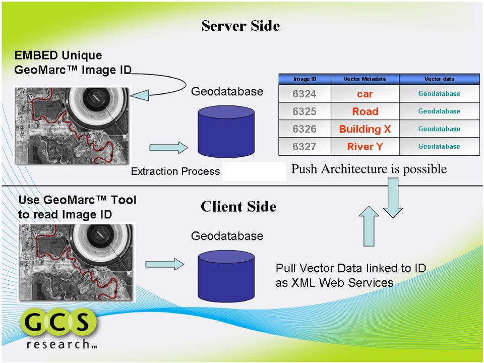
16 GeoMarc Feature Extraction Vision A) Extract and embed GeoMarc once; B) Store in distributed server federated constellation or one dedicated server; C) Share single image file across network; C) Access vector features locally or via web services for enterprise solution

17 Push Architecture is possible
18
19 Prototypical Solution: A) GeoMarc Image ID # embedded in raster image as Extraction Process occurs; B) Link Image ID to extracted vector data and metadata and/or extraction algorithm libraries in RDBMS; C) Distribute GeoMarc image across network not extracted data; D) User retrieves vector data using unique Image ID embedded in raster push and/or pull architecture; E) Metadata connectivity parent raster to vector extractions;
 Metadata connectivity parent raster to vector")
20 Smart Data Program GeoMarc Special Project Real-time GEOINT embedded in streaming UAS video systems TRL 7-8 Flight Demonstration Success Multi-variable watermarking algorithm FPGA Smart Card Development Interact with Satellite and Aerial Photography GeoMarcs

21 Smart Data Program: Phase II ) Video - Metadata Capture 2) Metadata Video Fusion 2) SmartTag: SourceID Time Stamp Frame Coordinates ATR Symbols Advanced Gimbals SmartTag 4) C4ISR Exploitation Actionable GEOINT 3) Smart Data Linking Web Services Smart Video
22 Smart Data Work Flow A-Z of Spatial DNA Video Collect Metadata Encode GPS, ATR, Time, Flags, and Routing Links (Advanced Gimbals) Transmit Bandwidth, Power, Distance, UAS Class Decode Extract metadata package Structure Web Services ISAA XML Distributed to C4ISR GEOINT Utility What, Where, and When + Plus Streaming Video All Digital System WIFI in the Sky + IP Configurable Application Mission-oriented LBS Push Architecture Linking to Ground Assets Move Beyond Search Mechanism Store, Retrieve, Index, Parse, Correlate, Analyze, Geospatial Functions (Proximity, Distance, Virtual Fence, Compare with other sensor networks as managed GEOINT Web Services) Microburst of Threat Intelligence for Tactical Situational Awareness Introduce Network and Routing Management
23 Smart Border Project Integrated Situational Awareness Architecture Next-Generation Surveillance, Intelligence, and Interdiction Determine Coordinate Value, Time, and Signature Adelos Sensor (Buried Fiber Optic Cable) XML Managed Web Services IP Configurable Transmit Coordinate and Target Type to UAS and Other Sensor Systems Human Assets Target Intercept GCS Research LLCUAS Proprietary Smart Data Target Type, GPS, and Video Capture in Data Channel
24 Geospatial Intelligence from Global Sensor Network Dynamic Geospatial Recombination Digital Geospatial Imagery AOIs, Mosaics, Vector Derivitatives, Metadata, and Targets (Discrete Data Capture) Digital Geospatial Acoustic (Continuous sensing element) Digital Geospatial Video (Continuous and Discrete)
25 Moving Beyond Search Geospatial Bits as Programmable DNA Smart Data Defined User Profile - Where? When? What? My Spatial Domain GeoMarc Sequence GeoMarc Dimensions Spatial Temporal Ontology
26 Distributed Geospatial Framework for Smart Data Exploitation Across Battlescape Smart Data Smart Tag Payload Definition Defined Mission Profile Last Mile GeoINT GeoINT Microbursts GeoMarc Smart Tag Registry GeoCOP Geodatabase Servers Geospatial Video and Battlescape GeoINT
27 Real-Time Sensor Fusion Utilizes Geospatial Registry and Smart Tag Push Architecture GeoINT Microbursts Smart Tag Smart Tag Low Bandwidth Bursts Smart Tag GeoBrief
28 Contact Mike Beltz VP of Sales and Marketing (Facsimile) Dr. Alex Philp East Broadway, Suite 113 Montana Technology Enterprise Center Missoula, MT 59812
Advanced Image Management using the Mosaic Dataset
 Esri International User Conference San Diego, California Technical Workshops July 25, 2012 Advanced Image Management using the Mosaic Dataset Vinay Viswambharan, Mike Muller Agenda ArcGIS Image Management
ArcGIS for. Intelligence
 ArcGIS for ArcGIS for solutions.arcgis.com/intelligence Copyright 2015 Esri. All rights reserved. 146660 DUAL3M7/15rk Briefing Book ArcGIS for Briefing Book ArcGIS Web Application ArcGIS for Create and
The premier software for extracting information from geospatial imagery.
 Imagery Becomes Knowledge ENVI The premier software for extracting information from geospatial imagery. ENVI Imagery Becomes Knowledge Geospatial imagery is used more and more across industries because
ENVI THE PREMIER SOFTWARE FOR EXTRACTING INFORMATION FROM GEOSPATIAL IMAGERY.
 ENVI THE PREMIER SOFTWARE FOR EXTRACTING INFORMATION FROM GEOSPATIAL IMAGERY. ENVI Imagery Becomes Knowledge ENVI software uses proven scientific methods and automated processes to help you turn geospatial
AV-18 Introduction of the GIS Integration
 Slide 1 AV-18 Introduction of the GIS Integration Authors Victor Lough Dan Marsillo Geoff Tarcha social.invensys.com @InvensysOpsMgmt / #SoftwareRevolution /InvensysVideos /InvensysOpsMgmt /company/invensys
GIS Databases With focused on ArcSDE
 Linköpings universitet / IDA / Div. for human-centered systems GIS Databases With focused on ArcSDE Imad Abugessaisa g-imaab@ida.liu.se 20071004 1 GIS and SDBMS Geographical data is spatial data whose
ArcGIS Data Models Practical Templates for Implementing GIS Projects
 ArcGIS Data Models Practical Templates for Implementing GIS Projects GIS Database Design According to C.J. Date (1995), database design deals with the logical representation of data in a database. The
ArcGIS. Server. A Complete and Integrated Server GIS
 ArcGIS Server A Complete and Integrated Server GIS ArcGIS Server A Complete and Integrated Server GIS ArcGIS Server enables you to distribute maps, models, and tools to others within your organization
Providing On-Demand Situational Awareness
 ITT Exelis Geospatial Intelligence Solutions Providing On-Demand Situational Awareness Use of U.S. Department of Defense (DoD) and U.S. Army imagery in this brochure does not constitute or imply DoD or
Processing, Cataloguing and Distribution of UAS Images in Near-Real-Time. Andreas Kühnen GEOSYSTEMS
 Processing, Cataloguing and Distribution of UAS Images in Near-Real-Time Andreas Kühnen GEOSYSTEMS Copyright GEOSYSTEMS GmbH 2013. Irrtum und Änderungen vorbehalten. R&D project of German Army System zur
Statement of Qualifications
 Statement of Qualifications Prepared By: JAYA Corporation 4900 University Square, Suite 30 Huntsville, AL 35816 TEL: (256) 722-0700 FAX: (256) 722-0711 EMAIL: igis@jaya corp.com Small Disadvantaged Business,
Developing Fleet and Asset Tracking Solutions with Web Maps
 Developing Fleet and Asset Tracking Solutions with Web Maps Introduction Many organizations have mobile field staff that perform business processes away from the office which include sales, service, maintenance,
Implementing an Imagery Management System at Mexican Navy
 Implementing an Imagery Management System at Mexican Navy The Mexican Navy safeguards 11,000 kilometers of Mexican coastlines, inland water bodies suitable for navigation, and the territorial sea and maritime
NetCDF and HDF Data in ArcGIS
 2013 Esri International User Conference July 8 12, 2013 San Diego, California Technical Workshop NetCDF and HDF Data in ArcGIS Nawajish Noman Kevin Butler Esri UC2013. Technical Workshop. Outline NetCDF
Storage Area Networks (SANs) and iscsi Protocol An Introduction to New Storage Technologies
 and iscsi Protocol An Introduction to New Storage Technologies") Page 1 Storage Area Networks (SANs) and iscsi Protocol An Introduction to New Storage Technologies Introduction This paper explains the concepts of Storage Area Network or SAN, iscsi technology and how
Page 1 Storage Area Networks (SANs) and iscsi Protocol An Introduction to New Storage Technologies Introduction This paper explains the concepts of Storage Area Network or SAN, iscsi technology and how
APFO Data Provisioning and Services
 Who We Are APFO is the primary source of aerial imagery for the U.S. Department of Agriculture. Data Stewards for NAIP, and historical aerial photography collected for USDA dating back to 1955. Who We
Big Data and Analytics: Getting Started with ArcGIS. Mike Park Erik Hoel
 Big Data and Analytics: Getting Started with ArcGIS Mike Park Erik Hoel Agenda Overview of big data Distributed computation User experience Data management Big data What is it? Big Data is a loosely defined
Product Characteristics Page 2. Management & Administration Page 2. Real-Time Detections & Alerts Page 4. Video Search Page 6
 Data Sheet savvi Version 5.3 savvi TM is a unified video analytics software solution that offers a wide variety of analytics functionalities through a single, easy to use platform that integrates with
INTEROPERABLE IMAGE DATA ACCESS THROUGH ARCGIS SERVER
 INTEROPERABLE IMAGE DATA ACCESS THROUGH ARCGIS SERVER Qian Liu Environmental Systems Research Institute 380 New York Street Redlands, CA92373, U.S.A - qliu@esri.com KEY WORDS: OGC, Standard, Interoperability,
About As. In a team with the best. ESRI Bulgaria is the exclusive distributor of Esri Inc. for Bulgaria. Esri Inc.
 About As ESRI Bulgaria is an IT company, leader in the field of Geographic Information Systems (GIS) on the Bulgarian market. Offering the most advanced high-tech products, solutions and services, ESRI
Institute of Natural Resources Departament of General Geology and Land use planning Work with a MAPS
 Institute of Natural Resources Departament of General Geology and Land use planning Work with a MAPS Lecturers: Berchuk V.Y. Gutareva N.Y. Contents: 1. Qgis; 2. General information; 3. Qgis desktop; 4.
Wireless Remote Video Monitoring
 February 2010 Page 1 An Emerson Smart Solution brings visual information into your control room. Increase Plant Safety Comply with Regulations Scalable Reduced Cost Secure and Reliable Communications Full
Big Data Volume & velocity data management with ERDAS APOLLO. Alain Kabamba Hexagon Geospatial
 Big Data Volume & velocity data management with ERDAS APOLLO Alain Kabamba Hexagon Geospatial Intergraph is Part of the Hexagon Family Hexagon is dedicated to delivering actionable information through
可 视 化 与 可 视 计 算 概 论. Introduction to Visualization and Visual Computing 袁 晓 如 北 京 大 学 2015.12.23
 可 视 化 与 可 视 计 算 概 论 Introduction to Visualization and Visual Computing 袁 晓 如 北 京 大 学 2015.12.23 2 Visual Analytics Adapted from Jim Thomas s slides 3 Visual Analytics Definition Visual Analytics is the
Database Production and Map Series Management. Using. The Production Line Tool Set
 Database Production and Map Series Management Using The Production Line Tool Set Dewey Marino - ESRI Redlands Production Line Tool Set ArcGIS Solution for high volume database and map creation Creates
IntelCenter Database (ICD) for Colleges & Universities 30 Jan. 2015. info@intelcenter.com 800-719-8750
 for Colleges & Universities 30 Jan. 2015. info@intelcenter.com 800-719-8750") IntelCenter Database (ICD) for Colleges & Universities 30 Jan. 2015 info@intelcenter.com 800-719-8750 1 IntelCenter Database (ICD) Students can watch events directly instead of just reading about them
IntelCenter Database (ICD) for Colleges & Universities 30 Jan. 2015 info@intelcenter.com 800-719-8750 1 IntelCenter Database (ICD) Students can watch events directly instead of just reading about them
MrSID Plug-in for 3D Analyst
 LizardTech MrSID Plug-in for 3D Analyst User Manual Copyrights Copyright 2009 2010 LizardTech. All rights reserved. Information in this document is subject to change without notice. The software described
Your Data, Any Place, Any Time. Microsoft SQL Server 2008 provides a trusted, productive, and intelligent data platform that enables you to:
 Your Data, Any Place, Any Time. Microsoft SQL Server 2008 provides a trusted, productive, and intelligent data platform that enables you to: Run your most demanding mission-critical applications. Reduce
Open Source UAS Software Toolkits. Keith Fieldhouse Technical Lead, Kitware Inc. keith.fieldhouse@kitware.com
 Open Source UAS Software Toolkits Keith Fieldhouse Technical Lead, Kitware Inc. keith.fieldhouse@kitware.com 1 Best known for open source toolkits and applications Collaborative software R&D: Algorithms
Mapping Mashup/Data Integration Development Resources Teaching with Google Earth and Google Ocean Stone Lab August 13, 2010
 Mapping Mashup/Data Integration Development Resources Teaching with Google Earth and Google Ocean Stone Lab August 13, 2010 David Hart GIS Specialist University of Wisconsin Sea Grant Institute Virtual
IP-S2 Compact+ 3D Mobile Mapping System
 IP-S2 Compact+ 3D Mobile Mapping System 3D scanning of road and roadside features Delivers high density point clouds and 360 spherical imagery High accuracy IMU options without export control Simple Map,
The Courses. Covering complete breadth of GIS technology from ESRI including ArcGIS, ArcGIS Server and ArcGIS Engine.
 ESRI India: Corporate profile ESRI India A profile India s Premier GIS Company Strategic alliance between ESRI Inc. and NIIT Technologies Adjudged as India s Best GIS Solutions Company - Map India 2001
Chapter 1: Introduction to ArcGIS Server
 Chapter 1: Introduction to ArcGIS Server At a high level you can think of ArcGIS Server as software that helps you take your geographic information and make it available to others. This data can be distributed
A GIS helps you answer questions and solve problems by looking at your data in a way that is quickly understood and easily shared.
 A Geographic Information System (GIS) integrates hardware, software, and data for capturing, managing, analyzing, and displaying all forms of geographically referenced information. GIS allows us to view,
USING THE INTERNET TO MANAGE AND DISTRIBUTE GEOSPATIAL SUBMARINE CABLE DATA
 USING THE INTERNET TO MANAGE AND DISTRIBUTE GEOSPATIAL SUBMARINE CABLE DATA GIS Database World Wide Web Internet Data Management Cable Marine RPL Protection David Caswell, Bill Gilmour, David Millar Racal
Applications of Deep Learning to the GEOINT mission. June 2015
 Applications of Deep Learning to the GEOINT mission June 2015 Overview Motivation Deep Learning Recap GEOINT applications: Imagery exploitation OSINT exploitation Geospatial and activity based analytics
Data Fusion Centers. Transforming Public Safety Information into Actionable Knowledge
 Data Fusion Centers Transforming Public Safety Information into Actionable Knowledge Defining Geospatial Data Fusion Homeland security relies on fusion the ability to capture and analyze data from multiple
Integrated Physical Security and Incident Management
 IT Enterprise Services Integrated Physical Security and Incident Management Every organisation needs to be confident about its physical security and its ability to respond to unexpected incidents. Protecting
GIS and Mapping Solutions for Developers. ESRI Developer Network (EDN SM)
") GIS and Mapping Solutions for Developers ESRI Developer Network (EDN SM) GIS and Mapping Solutions for Developers If you are a software developer looking for an effective way to bring geographic and mapping
GIS and Mapping Solutions for Developers ESRI Developer Network (EDN SM) GIS and Mapping Solutions for Developers If you are a software developer looking for an effective way to bring geographic and mapping
Real-time Networked Desktop Distribution
 Barco Defense, Aerospace & Training Real-time Networked Desktop Distribution Evolving from dedicated DVI/KVM switching to real-time networked visualization Content Introduction Traditional KVM vs Real-Time
White Paper. The Next Generation Video Codec Scalable Video Coding (SVC)
") White Paper The Next Generation Video Codec Scalable Video Coding (SVC) Contents Background... 3 What is SVC?... 3 Implementations of SVC Technology: VIVOTEK as an Example... 6 Conclusion... 10 2 Background
White Paper The Next Generation Video Codec Scalable Video Coding (SVC) Contents Background... 3 What is SVC?... 3 Implementations of SVC Technology: VIVOTEK as an Example... 6 Conclusion... 10 2 Background
ArcGIS. Image Server tutorial
 ArcGIS 9 ArcGIS Image Server tutorial Copyright 2006, 2007, and 2008 Zanja Technologies, Inc. All rights reserved. The information contained in this work is the property of Zanja Technologies, Inc., under
Technology Trends In Geoinformation
 Technology Trends In Geoinformation Dato Prof. Sr Dr. Abdul Kadir Bin Taib Department of Survey and Mapping Malaysia (JUPEM) Email: drkadir@jupem.gov.my www.jupem.gov.my NGIS 2008 3 rd. National GIS Conference
NEW TOOLS, NEW HEIGHTS IN PERFORMANCE AND EFFECTIVENESS 4.9
 NEW TOOLS, NEW HEIGHTS IN PERFORMANCE AND EFFECTIVENESS 4.9 Intellect PSIM Intellect is a platform for physical security information management with a modular architecture, scaling up to create integrated
Oklahoma s Open Source Spatial Data Clearinghouse: OKMaps
 Oklahoma s Open Source Spatial Data Clearinghouse: OKMaps Presented by: Mike Sharp State Geographic Information Coordinator Oklahoma Office of Geographic Information MAGIC 2014 Symposium April 28-May1,
Applications of Mobile GIS in Forestry South Australia
 Applications of Mobile GIS in Forestry South Australia D. T. Battad a, P. Mackenzie b a South Australian Forestry Corporation, Mt. Gambier, South Australia, Australia 5290 - battad.dionisio@forestrysa.com.au
Deploying ArcGIS for Server Using Managed Services
 Deploying ArcGIS for Server Using Managed Services Andrew Sakowicz Erin Ross Sridhar Karra Agenda Introduction Program Overview - Overview - Methodology - Tools Customer Deployments - Architecture and
Big Data, Cloud Computing, Spatial Databases Steven Hagan Vice President Server Technologies
 Big Data, Cloud Computing, Spatial Databases Steven Hagan Vice President Server Technologies Big Data: Global Digital Data Growth Growing leaps and bounds by 40+% Year over Year! 2009 =.8 Zetabytes =.08
Windows Embedded Security and Surveillance Solutions
 Windows Embedded Security and Surveillance Solutions Windows Embedded 2010 Page 1 Copyright The information contained in this document represents the current view of Microsoft Corporation on the issues
An Esri White Paper August 2010 Product Library in Esri Aeronautical Solution: Enabling Seamless Product, Data, and Document Management
 An Esri White Paper August 2010 Product Library in Esri Aeronautical Solution: Enabling Seamless Product, Data, and Document Management Esri, 380 New York St., Redlands, CA 92373-8100 USA TEL 909-793-2853
BLACKBRIDGE SATELLITE IMAGERY THROUGH CLOUD COMPUTING
 BLACKBRIDGE SATELLITE IMAGERY THROUGH CLOUD COMPUTING Jason Setzer Cloud Product Manager Slide 1 THE RAPID EYE CONSTELLATION 5 Identical Satellites in same obit Up to 5 million km² collected daily 1 billion
Making Your Mobile Workforce More Efficient
 ArcGIS for Mobile Making Your Mobile Workforce More Efficient What Is Mobile GIS? Mobile geographic information system (GIS) technology extends GIS beyond the office and allows organizations to make accurate,
Wireless Remote Video Monitoring
 October 2014 Page 1 An Emerson Smart Solution brings visual information into your control room. Increase plant safety Comply with regulations Scalable Reduced cost Secure and reliable communications Full
Chapter Contents Page No
 Chapter Contents Page No Preface Acknowledgement 1 Basics of Remote Sensing 1 1.1. Introduction 1 1.2. Definition of Remote Sensing 1 1.3. Principles of Remote Sensing 1 1.4. Various Stages in Remote Sensing
Introduction to Imagery and Raster Data in ArcGIS
 Esri International User Conference San Diego, California Technical Workshops July 25, 2012 Introduction to Imagery and Raster Data in ArcGIS Simon Woo slides Cody Benkelman - demos Overview of Presentation
An Esri White Paper October 2010 Esri Production Mapping Product Library: Spatially Enabled Document Management System
 An Esri White Paper October 2010 Esri Production Mapping Product Library: Spatially Enabled Document Management System Esri, 380 New York St., Redlands, CA 92373-8100 USA TEL 909-793-2853 FAX 909-793-5953
An Esri White Paper June 2010 Tracking Server 10
 An Esri White Paper June 2010 Tracking Server 10 Esri 380 New York St., Redlands, CA 92373-8100 USA TEL 909-793-2853 FAX 909-793-5953 E-MAIL info@esri.com WEB www.esri.com Copyright 2010 Esri All rights
New Technology Capabilities
 New Technology Capabilities Software/Applications 1. Biometric ID capability 2. Standardized secure, connectivity, and storage of data (bio, roles, etc) 3. Rules- based expert engine a. Automated dispatch
Mapping Mashup/Data Integration Development Resources
 Mapping Mashup/Data Integration Development Resources David Hart GIS Specialist University of Wisconsin Sea Grant Institute October 6, 2008 Virtual Globes A virtual globe is a 3D software model or representation
Trends and Research Opportunities in Spatial Big Data Analytics and Cloud Computing NCSU GeoSpatial Forum
 Trends and Research Opportunities in Spatial Big Data Analytics and Cloud Computing NCSU GeoSpatial Forum Siva Ravada Senior Director of Development Oracle Spatial and MapViewer 2 Evolving Technology Platforms
An Esri White Paper June 2007 Developing and Deploying an Integrated Geoenabled SOA Business Solution: A Case Study
 An Esri White Paper June 2007 Developing and Deploying an Integrated Geoenabled SOA Business Solution: A Case Study Esri, 380 New York St., Redlands, CA 92373-8100 USA TEL 909-793-2853 FAX 909-793-5953
Bryan Tuft Sr. Sales Consultant Global Embedded Business Unit bryan.tuft@oracle.com
 Bryan Tuft Sr. Sales Consultant Global Embedded Business Unit bryan.tuft@oracle.com Agenda Oracle Approach Embedded Databases TimesTen In-Memory Database Snapshots Q&A Real-Time Infrastructure Challenges
Your Data, Any Place, Any Time.
 Your Data, Any Place, Any Time. Microsoft SQL Server 2008 provides a trusted, productive, and intelligent data platform that enables you to: Run your most demanding mission-critical applications. Reduce
Web Traffic Capture. 5401 Butler Street, Suite 200 Pittsburgh, PA 15201 +1 (412) 408 3167 www.metronomelabs.com
 408 3167 www.metronomelabs.com") Web Traffic Capture Capture your web traffic, filtered and transformed, ready for your applications without web logs or page tags and keep all your data inside your firewall. 5401 Butler Street, Suite
Web Traffic Capture Capture your web traffic, filtered and transformed, ready for your applications without web logs or page tags and keep all your data inside your firewall. 5401 Butler Street, Suite
The needs on big data management for Operational Geo-Info Services: Emergency Response, Maritime surveillance, Agriculture Management
 Copernicus Big-Data Workshop 2014, 13/14 March The needs on big data management for Operational Geo-Info Services: Emergency Response, Maritime surveillance, Agriculture Management Marco Corsi e-geos 1
Integrated Information Management System, Development of Web Interface, a.k.a. Online Data Portal (ODP)
") Integrated Information Management System, Development of Web Interface, a.k.a. Online Data Portal (ODP) USBR Science and Technology Project ID 3625 Eric Peterson, May 2014. Duration: Fiscal Year 2010 through
Integrated Information Management System, Development of Web Interface, a.k.a. Online Data Portal (ODP) USBR Science and Technology Project ID 3625 Eric Peterson, May 2014. Duration: Fiscal Year 2010 through
Deploying ArcGIS for Server Using Esri Managed Services
 Federal GIS Conference 2014 February 10 11, 2014 Washington DC Deploying ArcGIS for Server Using Esri Managed Services Andrew Sakowicz Erin Ross Cloud Overview Deploying ArcGIS for Server What is Cloud:
Digimarc for Images. Best Practices Guide (Chroma + Classic Edition)
") Digimarc for Images Best Practices Guide (Chroma + Classic Edition) Best Practices Guide (Chroma + Classic Edition) Why should you digitally watermark your images? 3 What types of images can be digitally
Digimarc for Images Best Practices Guide (Chroma + Classic Edition) Best Practices Guide (Chroma + Classic Edition) Why should you digitally watermark your images? 3 What types of images can be digitally
Where is... How do I get to...
 Big Data, Fast Data, Spatial Data Making Sense of Location Data in a Smart City Hans Viehmann Product Manager EMEA ORACLE Corporation August 19, 2015 Copyright 2014, Oracle and/or its affiliates. All rights
W H I T E P A P E R. Security & Defense Solutions Intelligent Convergence with EdgeFrontier
 W H I T E P A P E R Security & Defense Solutions Intelligent Convergence with EdgeFrontier Contents 1. Introduction... 2 2. The Need for Intelligent Convergence... 3 2.1 Security Convergence with EdgeFrontier...
Graphical Processing Units to Accelerate Orthorectification, Atmospheric Correction and Transformations for Big Data
 Graphical Processing Units to Accelerate Orthorectification, Atmospheric Correction and Transformations for Big Data Amanda O Connor, Bryan Justice, and A. Thomas Harris IN52A. Big Data in the Geosciences:
A New Cloud-based Deployment of Image Analysis Functionality
 243 A New Cloud-based Deployment of Image Analysis Functionality Thomas BAHR 1 and Bill OKUBO 2 1 Exelis Visual Information Solutions GmbH, Gilching/Germany thomas.bahr@exelisvis.com 2 Exelis Visual Information
DC Mobile Workforce Management
 THIS IS AN INTERNAL DOCUMENT PLEASE DO NOT DISTRIBUTE Available ONLY to NAG & GOOGLE Personnel Pricing w ill vary according to opportunity IT-SERVUS Attention: Chum Chancharadeth, Director Government of
City of Memphis Purchase of Data Migration Services
 Addendum #1 Date: June 15, 2016 TO ALL POTENTIAL BIDDERS: Science Applications International Corporation ( SAIC ) Request for Proposal (RFP) City of Memphis Purchase of Data Migration Services RFP # SAIC
How To Build Gis Applications With An Arcgis Engine
 Delivering Custom GIS Applications With ArcGIS Engine An ESRI White Paper February 2004 ESRI 380 New York St., Redlands, CA 92373-8100, USA TEL 909-793-2853 FAX 909-793-5953 E-MAIL info@esri.com WEB www.esri.com
Data Mining and Analysis in ArcGIS Online Joseph Kerski Education Manager Esri jkerski@esri.com Twitter @josephkerski 303-449-7779 x 18237
 Data Mining and Analysis in ArcGIS Online Joseph Kerski Education Manager Esri jkerski@esri.com Twitter @josephkerski 303-449-7779 x 18237 Joseph Kerski Webinar 1 Goals for this workshop 1. Understanding
Brown County Information Technology Aberdeen, SD. Request for Proposals For Document Management Solution. Proposals Deadline: Submit proposals to:
 Brown County Information Technology Aberdeen, SD Request for Proposals For Document Management Solution Proposals Deadline: 9:10am, January 12, 2016 Submit proposals to: Brown County Auditor 25 Market
Geospatially Enabling the World: The Convergence of Geospatial and Architectural and Engineering Design
 Geospatially Enabling the World: The Convergence of Geospatial and Architectural and Engineering Design Geoff Zeiss Director of Technology Autodesk Map Middle East Dubai 2007 1 Overview Geospatial inflection
An Oracle White Paper February 2009. Managing Unstructured Data with Oracle Database 11g
 An Oracle White Paper February 2009 Managing Unstructured Data with Oracle Database 11g Introduction The vast majority of the information used by corporations, enterprises, and other organizations is referred
FME 2007 Release Giving Raster the Vector Treatment. By Mary Jo Wagner
 FME 2007 Release Giving Raster the Vector Treatment By Mary Jo Wagner Giving Raster the Vector Treatment By Mary Jo Wagner Spatial extract, transform and load (ETL) tools such as Safe Software s FME have
A Model-based Methodology for Developing Secure VoIP Systems
 A Model-based Methodology for Developing Secure VoIP Systems Juan C Pelaez, Ph. D. November 24, 200 VoIP overview What is VoIP? Why use VoIP? Strong effect on global communications VoIP will replace PSTN
Making Your Mobile Workforce More Efficient
 ArcGIS for Mobile Making Your Mobile Workforce More Efficient What Is Mobile GIS? Mobile geographic information system (GIS) technology extends GIS beyond the office and allows organizations to make accurate,
ArcGIS Workflow Manager: An Overview
 Federal GIS Conference February 9 10, 2015 Washington, DC ArcGIS Workflow Manager: An Overview Heather Murnane & Elizabeth Wilcox Session Topics Overview Key Features Notification & Reporting Overview
An Esri White Paper June 2011 ArcGIS for INSPIRE
 An Esri White Paper June 2011 ArcGIS for INSPIRE Esri, 380 New York St., Redlands, CA 92373-8100 USA TEL 909-793-2853 FAX 909-793-5953 E-MAIL info@esri.com WEB esri.com Copyright 2011 Esri All rights reserved.
How To Compress Video For Real Time Transmission
 University of Edinburgh College of Science and Engineering School of Informatics Informatics Research Proposal supervised by Dr. Sethu Vijayakumar Optimized bandwidth usage for real-time remote surveillance
Using PCI Geomatics Software with Oracle 10g Spatial and GeoRaster A PCI Geomatics Whitepaper
 Using PCI Geomatics Software with Oracle 10g Spatial and GeoRaster A PCI Geomatics Whitepaper November 2005 Table of Contents Table of Contents...1 1. Introduction...2 2. How Geomatica adds value to Oracle
Security and protection of digital images by using watermarking methods
 Security and protection of digital images by using watermarking methods Andreja Samčović Faculty of Transport and Traffic Engineering University of Belgrade, Serbia Gjovik, june 2014. Digital watermarking
The following was presented at DMT 14 (June 1-4, 2014, Newark, DE).
.") DMT 2014 The following was presented at DMT 14 (June 1-4, 2014, Newark, DE). The contents are provisional and will be superseded by a paper in the DMT 14 Proceedings. See also presentations and Proceedings
DMT 2014 The following was presented at DMT 14 (June 1-4, 2014, Newark, DE). The contents are provisional and will be superseded by a paper in the DMT 14 Proceedings. See also presentations and Proceedings
Advancing Sustainability with Geospatial Steven Hagan, Vice President, Server Technologies João Paiva, Ph.D. Spatial Information and Science
 Advancing Sustainability with Geospatial Steven Hagan, Vice President, Server Technologies João Paiva, Ph.D. Spatial Information and Science Engineering 1 Copyright 2011, Oracle and/or its affiliates.
Vision. South Pacific GIS/RS Conference 2015 11/17/2015. Applying Geography Everywhere. Applying Geography Everywhere
 South Pacific GIS/RS Conference 2015 Applying Geography Everywhere Jithen (J) Singh Eagle Technology Group Ltd (Esri New Zealand) Suva, Fiji Vision Applying Geography Everywhere 1 GIS Is Evolving A Whole
Information and Understanding (IFU) Overview
 Overview") Information and Understanding (IFU) Overview Jun 8 th, 2010 Mark Pronobis IFU CTC Lead AFRL/RIEF mark.pronobis@rl.af.mil Approved for Public Release; Distribution Unlimited: 88ABW-2010-2619 dated 13 May
Information and Understanding (IFU) Overview Jun 8 th, 2010 Mark Pronobis IFU CTC Lead AFRL/RIEF mark.pronobis@rl.af.mil Approved for Public Release; Distribution Unlimited: 88ABW-2010-2619 dated 13 May
Google Earth Digitale Wege in eine bekannte Welt Sep. 2006
 Google Earth Digitale Wege in eine bekannte Welt Sep. 2006 Joachim Glaubrecht Google Enterprise joachim@google.com What is Google Enterprise? 2 1 Focus.de: "Der Papst-Besuch in Google Earth" 3 How to Geo
IP Video Surveillance
 IP Video Surveillance Solutions and Services Wireless IP PDA Administration Wireless Access Point Viewer Remote Control IP Video Server IP Network Alarm Management Video Recording Analog Video Server Access
How To Protect Video From Being Lost In A Fault Fault On A Network With A Shadow Archive
 A MARCH NETWORKS WHITE PAPER Shadow Archiving in Video Surveillance Systems Fail Safe Recording Options for IP Edge Devices Table of Contents Executive Summary...2 Introduction...2 Background...2 DVR
GeoManitoba Spatial Data Infrastructure Update. Presented by: Jim Aberdeen Shawn Cruise
 GeoManitoba Spatial Data Infrastructure Update Presented by: Jim Aberdeen Shawn Cruise Organization Overview Manitoba Innovation Energy and Mines Business Transformation and Technology (BTT) Application
White paper. Axis Video Analytics. Enhancing video surveillance efficiency
 White paper Axis Video Analytics Enhancing video surveillance efficiency Table of contents 1. What is video analytics? 3 2. Why use video analytics? 3 2.1 Efficient use of manpower 3 2.2 Reduced network
Gi-Joon Nam, IBM Research - Austin Sani R. Nassif, Radyalis. Opportunities in Power Distribution Network System Optimization (from EDA Perspective)
") Gi-Joon Nam, IBM Research - Austin Sani R. Nassif, Radyalis Opportunities in Power Distribution Network System Optimization (from EDA Perspective) Outline! SmartGrid: What it is! Power Distribution Network
Gi-Joon Nam, IBM Research - Austin Sani R. Nassif, Radyalis Opportunities in Power Distribution Network System Optimization (from EDA Perspective) Outline! SmartGrid: What it is! Power Distribution Network
Zorba Asset Tracking Solution
 Asset Tracking Solution State-of-the art fleet management and vehicle tracking solution to increase your productivity. Affordable installation and operating costs Easy to install and operate User friendly
Michigan Tech Research Institute Wetland Mitigation Site Suitability Tool
 Michigan Tech Research Institute Wetland Mitigation Site Suitability Tool Michigan Tech Research Institute s (MTRI) Wetland Mitigation Site Suitability Tool (WMSST) integrates data layers for eight biophysical