Tectonics of Eastern Mexico Gulf of Mexico and its Hydrocarbon Potential*
|
|
|
- Meredith Gregory
- 8 years ago
- Views:
Transcription
1 Tectonics of Eastern Mexico Gulf of Mexico and its Hydrocarbon Potential* Ricardo J. Padilla y Sánchez 1 Search and Discovery Article #10622 (2014)** Posted August 11, 2014 *Adapted from oral presentation at AAPG Annual Convention and Exhibition, Houston, Texas, April 6-9, 2014, and the Geoscience Technology Workshop Sixth Deepwater and Shelf Reservoir, Houston, Texas, January 27-28, 2015 **Datapages 2014 Serial rights given by author. For all other rights contact author directly. 1 División de Ingeniería en Ciencias de la Tierra, Universidad Nacional Autónoma de México, México, Distrito Federal, Mexico (ricardojpadilla@gmail.com; rpadilla@unam.mx) Abstract Major oil and gas reservoirs occur in Mexico in seven main basins, from northwest to southeast: Sabinas, Burgos, Tampico- Misantla, Chicontepec, Veracruz, Salina del Istmo, and Macuspana y Comalcalco; over, or around carbonate build-ups, of buried basement horsts like the Golden Lane and Akal Horst, as well as in salt-related structures. These features are located along the Gulf Coastal Plain, onshore and offshore, between the Sierra Madre Oriental on the west, and the Perdido Fold Belt, the Mexican Ridges, and the Yucatan Platform, on the east. The age of the source rocks for these conventional reservoirs is Tithonian, but could be even Kimmeridgian or Oxfordian. The regional migration trend for the hydrocarbons, generated by these sources and accumulated in the conventional known reservoirs, came most probably from east to west, from the deepest part of the Gulf of Mexico, upward to the final traps, in different times. A series of chronological paleogeographic maps are presented in order to try to understand the regional facies distribution and the orogenic events resulting from a combination of gravitydriven, passive margin, near-field stress-driven type 1 systems and a continuous transpressional state of stress due to the fastest movement of the northern portion of the North American Plate respect to Mexico, since the Mesozoic to the present. An additional evidence for the proposed routes of migration and today's activity of the petroleum system are the numerous oil-gas seeps in the Gulf of Mexico. A reliable estimate of the undiscovered recoverable conventional petroleum resources is presented.

2 Selected References Blakey, R., 2013, North American Paleogeography Key time Slices: Present (0 Ma), (website accessed July 5, 2014) Escalera Alcocer, J.A., 2013, Hydrocarbon exploration challenges and perspectives in Mexico: Search and Discovery Article #10539 (2013) (website accessed July 8, 2014) González, G.R., and Q.N. Holguín, 1991, Geology of the source rocks of Mexico. Source rock geology, in XIII World Petroleum Congress, Buenos Aires, Argentina, Topic 2, Forum with Posters, p González Garcia, R., and N. Holguín Quiñones (González, G.R., and Q.N. Holguín), 1992, Las Rocas generadoras de Mexico: Bol. AMGP, articulo reeditado del v. XLII, no. 1, p Hudec, M.R., I.O. Norton, M.P.A. Jackson, and F.J. Peel, 2013, Jurassic evolution of the Gulf of Mexico salt basin: AAPG Bulletin, v. 97, p Padilla y Sánchez, R., 1986, Post-Paleozoic tectonics of northeast Mexico and its role on the evolution of the Gulf of Mexico: Revista Geofísica Internacional, Instituto de Geofísica, v. 25/1, p Padilla y Sanchez, R., 2007, Evolucion geologica del sureste mexicano desde el Mezosoico al presente en el context regional del Golfo de Mexico: Boletin de la Sociedad Geologica Mexicana. Tomo LIX, Num. 1, p Padilla y Sánchez, R.J., I. Domínguez Trejo, A.G. López Azcárraga, J. Mota Nieto, A.O. Fuentes Menes, F. Rosique Naranjo, E.A. Germán Castelán, and S.E. Campos Arriola, 2013, National Autonomous University of Mexico Tectonic Map of Mexico GIS Project, American Association of Petroleum Geologists GIS Open Files series, (website accessed July 7, 2014)..
, 1992, Las Rocas generadoras de Mexico: Bol.")
3 Pemex, 2013a, Provincia Petrolera Sureste (Salina del Istmo, Reforma-Akal y Macuspana): Pemex Exploración y Producción Subdirección de Exploración, Versión 2.0, 2013, 57p. ( (website accessed July 5, 2014). Pemex, 2013b, Provincia Petrolera Tampico-Misantla: Pemex Exploración y Producción Subdirección de Exploración, Versión 2.0, 2013, 48p. Pindell, J., and L. Kennan, 2001, Kinematic evolution of the Gulf of Mexico and Caribbean: GCSSEPM Foundation 21st Annual Research Conference Transactions, Petroleum Systems of Deep-Water Basins, December 2-5, 2001, p Rangel-German, E., 2014, The new role of the Mexican upstream regulator: SSIII La Jolla 2014 Energy Conference, Institute of the Americas: /9-edgar-rangel+&cd=1&hl=en&ct=clnk&gl=us (website accessed July 7, 2014). Robin, C., Relations volcanologie magmatologie-geodynamique: Application au passage entre volcanismes alcalin et andesitique dans le sud Mexicain (Axe Trans-mexicain et Province Alcaline Oriental): Ph.D. Thesis, Annales Scientifiques de l Universite de Clermont-Ferrand II France, 503 p. Tari, G., and A.W. Bally, 2004, Interpretation of seismic data in a regional context: Developing frontier exploration opportunities: AAPG Winter Education Conference, lecture notes. Vázquezde la Certa, A.M., R.O. Reid, S.F. DiMarco, and A.E. Jochens, 2005, Bay of Campeche circulation: An update, in Circulation of the Gulf of Mexico: Observations and Models: Geophysical Monograph Series 161, American Geophysical Union, p

4 Tectonics of Eastern Mexico - Gulf of Mexico and its Hydrocarbon Potential Ricardo José Padilla y Sánchez División de Ingeniería en Ciencias de la Tierra, Facultad de Ingeniería, Universidad Nacional Autónoma de México AAPG-ACE-HOUSTON, April 2014

5 Tectonics of Eastern Mexico - Gulf of Mexico and its Hydrocarbon Potential Contents: Major oil & gas reservoirs in Mexico - GOM Petroleum basins of Mexico Source rocks Petroleum systems Late Paleozoic Cenozoic tectonic evolution Undiscovered recoverable resources

6 Major oil & gas reservoirs in Mexico Burgos Padilla y Sánchez et.al., 2013, AAPG Datapages

7 Major oil & gas reservoirs in Mexico Ébano, Pánuco, Faja de Oro Padilla y Sánchez et.al., 2013, AAPG Datapages

8 Major oil & gas reservoirs in Mexico Veracruz Padilla y Sánchez et.al., 2013, AAPG Datapages

9 Major oil & gas reservoirs in Mexico Sureste Padilla y Sánchez et.al., 2013, AAPG Datapages

10 Major oil & gas reservoirs in Mexico Región Marina Padilla y Sánchez et.al., 2013, AAPG Datapages

11 Petroleum basins of Mexico Chihuahua Burgos Sabinas Oil Gas Tampico-Misantla Chicontepec Veracruz Salina del Istmo- Comalcalco Macuspana Pilar de Akal Padilla y Sánchez et.al., 2013, AAPG Datapages

12 Source rocks Regional stratigraphic and geochemical characteristics of the Burgos Basin (Tomada de González y Holguin, 1991). González y Holguín, 1992
.")
13 Source rocks Regional stratigraphic and geochemical characteristics of the Tampico-Misantla Basin (Tomada de González y Holguin, 1991). González y Holguín, 1992
.")
14 Source rocks Regional stratigraphic and geochemical characteristics of the Veracruz Basin (Tomada de González y Holguin, 1991). González y Holguín, 1992
.")
15 Source rocks Simplified cross section and maturity of the Sureste Basin (Tomada de González y Holguin, 1991). González y Holguín, 1992
.")
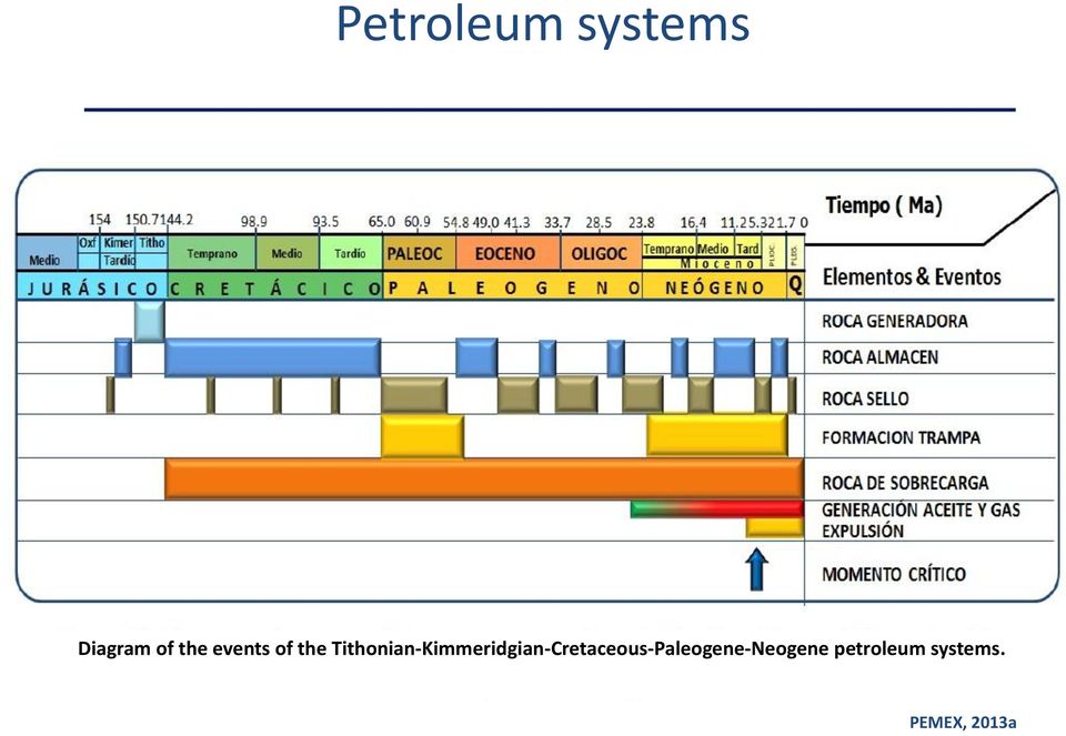
16 Petroleum systems Diagram of the events of the Tithonian-Kimmeridgian-Cretaceous-Paleogene-Neogene petroleum systems. PEMEX, 2013a

17 Petroleum system Diagram of the events of the Oxfordian petroleum system, representative of the terrestrial and marine parts of the Sureste petroleum province. PEMEX, 2013a


18 Petroleum system Table of the elements and events of the Lower-Middle Jurassic petroleum system of the Tampico- Misantla petroleum province. PEMEX, 2013b


19 Petroleum system Table of the elements and events of the petroleum system associated with Upper Jurassic source rocks. PEMEX, 2013b

20 Paleogeographic evolution of NA Ronald Blakey, 2013

21 Late Triassic paleogeography D D SEA LAND Red Beds o 500 Km
22 Callovian paleogeography D D SEA LAND o 500 Km
23 Oxfordian paleogeography D D SEA LAND o 500 Km
24 Kimmeridgian paleogeography D D SEA LAND 500 Km
25 Tithonian paleogeography SEA LAND o 500 Km
26 Early Cretaceous paleogeography SEA LAND o 500 Km
27 Barremian paleogeography SEA LAND o 500 Km
28 Albian paleogeography SEA LAND o 500 Km
29 Late Cretaceous paleogeography SEA LAND o 500 Km
30 Early Paleocene paleogeography D D SEA LAND J r' ) r ~.J.. ~ '-'I "' '>.- o 500 Km
31 Late Eocene paleogeography, ) D D SEA LAND 'I ( ) o 500 Km
32 Miocene paleogeography SEA LAND ( o 500 Km
33 Late Miocene paleogeography SEA LAND l (f/!~ I o 500 Km
34 Oligocene paleogeography SEA LAND 1If/; I/( o 500 Km
35 Plio-pleistocene paleogeography SEA LAND l tf/l~ I o 500 Km
36 Holocene paleogeography o o 500 Km
37 Today I \, 4\~~~~;~1~~1~J. c,r-t'"'nic Map 6f Mexico ' 013 ~~ i\\,-i';-"-l\.\lc---= \~- --I- I I Compiler: Fl.ICHdo J. Fadi la y ~nchel I Colab"atcrs \ DO r1 lnquez Tre lo, L. Lopez Az cmraga, AG.. Mota Nieto, J.,, F ~en :es lii enes, A.O.. Ac aiqu e N ~ r~ nio, F.. C" m,; n C8steh; n, ::.A". i I. S,E. Divis ion de Ingen\erja en C i~nd a s ce la n,m a, II I de Ingenieria Un,vor:;id"d N"c i ~ n,, 1 i\ u t6, om~ de M6,;oo I ) I I +-t_ -=r= \ \ \ --1 \, \ \ ----\ \ \ \ 750 I i I ,5?O ~"'''''~ '':'_I'"'... ooiol'"''''''''''''' Kilometers Padilla y Sánchez et.al., 2013, AAPG Datapages
38 Today
39 Opening of the Gulf of Mexico (A) 210 Ma-Norian, start of rifting (8) 163 Ma-Callovian, start of salt deposition I km North America North America extension -<--"'T"t: Yucatan block Yucatan block ~ ~ 1 /; / South America <, 1 South America Hudec et al., 2013
40 Opening of the Gulf of Mexico (C) 161 Ma-Caliovian, r- end of salt deposition Salt-restoration lines superimposed n (0) 155 Ma-Oxfordian, just before sea-floor spreading Salt-restoration lines ~.~~~~~ Hudec et al., 2013
41 Opening of the Gulf of Mexico (E) 149 Ma-Tithonian, sea-floor spreading I (F) Present ~----- f km postsalt stretchin~ ij" ~~~~d Salt-restoration lines Hudec et al., 2013
 and Chiapas (1\') blocks 8th.")
42 Opening of the Gulf of Mexico Limited stretching of thick upper plate NOlthern limit of detachment faulting Main GOM Thin or absent upper plate above detachment leads to high heat flow As Chiapas moves to SE Tamaulipas Arch is unroofed Middle Grounds Fault Bahamas Sonora A Mojave Megashear SE, opening Tampa Enlbayment pull-apart Successive positions of Chuacus (8) and Chiapas (1\') blocks 8th. Am. coast at 1 6oMa~ Successive positions of Yucatan - note how SE Yuc. always nestles in elbow between M8 Megashear and Maracaibo Transform Pindell and Kennan, 2001
43 Opening of the Gulf of Mexico Vazquez, 2005
44 Mayor tectonic features of Mexico + N lr t. 'U" 'U' /- -l +,,,. In- m,. 1IIi',.. nja Vol...:. ~ ~1,...;C... ~ Tran"" ic:.". (Pllo-Pl... toc... ol "'''' '... "' ",,'...,. -\.L.j +.,. oj.j ".!.' t t- nu' I"'" 10Ct " fill' Ill' Padilla y Sánchez, 2007
45 Cenozoic volcanism in Mexico Padilla y Sánchez (1986) Padilla y Sánchez (1986)
46 Crustal model of eastern Mexico ; : ; : ~ c v o f 4.0, 1 '0 - " " ~ " " J.,.I I \. 01 I l. U l MEXICO CONTINENTAL I RIFTED MANTLE TAMAULIPA$-OAXACA FAULT CRUST ----~.--~. " l,ul' COU111L 'LAlli,; 100 I...! CONT. l. U t." 1.lit 1.10 I ~ ~ -z. t' ~, y. r. t, _0. o CRUS T ABNORMAL OCEANI~ I b---- CRUST----, ,, ".,. 1 ~-~=:,:,,-=!~!!.=~= :::0= == = = = ~"~:~'~"~==1~ ~'!i:... '- 00-,, >., ~ TO ). 0 S 1.1,.. -, ' " '.f... '.0 ~?~ ---M-A"N~T~L~E7" ~ t.f - : / I. ' Numb~rs in Punla Jerel tolumn indicat e densities i., glee. othe rwise :ndicole PWQve ve locities in Km/uc - Abnormal rneofls on o'ceonic crusl covered by a It'I ;e k packo90 of sedimenls -- '-~~ n-.o~.,. Padilla y Sánchez (1986)
47 Tamaulipas-Oaxaca Fault Figur. 2. sat basi.. in the Gilt 01 MeR<o ''l!''''. our iott'1"ettd lini 01 "",mol ",earo<_ o in the basin. SIr",,,.. all,"ures lrom Mar'n (1980); Simm<>1' (l'l'l2); 11~. (19OS); L_ (I'1'lS); GoI<t\'''''''' and 'oiu>oo _~=~_=,,;50:.::q,~Km Lawton d al. (2001); Podi. Y s.ln<hez (2013). Ie< Hude< et a. (20n, 1I'is.,u.', '0<..iden<.1or lilc Boat'".""'" '.ul Hudec et al., 2013
48 Gravity Map of the GOM o 500 Km Hudec et al., 2013
49 Yucatan Block path ( ma) cm/year = 1,000 km/19 ma Padilla y Sánchez (1986)
50 Regional migration trends Geologic provinces of the Mexican part of the deep Gulf of Mexico. The section is an example of the structural styles of some of the provinces. A A The regional migration trend for the hydrocarbons generated by these sources came most probably from east to west, from the deepest part of the Gulf of Mexico, upward to the final traps, in different times. Escalera, 2010
51 Regional migration trends A A A A The regional migration trend for the hydrocarbons generated by these sources came most probably from east to west, from the deepest part of the Gulf of Mexico, upward to the final traps, in different times. Vazquez, 2005
52 Regional migration trends D D D D The regional migration trend for the hydrocarbons generated by these sources came most probably from east to west, from the deepest part of the Gulf of Mexico, upward to the final traps, in different times. Bally and Tari, 2004, AAPG Winter Education Conference

53 Reserves in Mexico Thousands of billions of barrels of oil equivalent Basin Prospective Reserves Cum. Resources Prod 1P 2P 3P Unco Conv. (90%) (50%) (1 0%) nv. Southeast Tampico Misantla Burgos Veracruz Sabinas Deep waters Yucatan plattform 0.5 Total Mexico's culllulative production, 1 P, 2P and 3P reserves, and conventional and unconventional resources. There are 1II0re than 200 billion barrels of oil equivalent associated to the 44.5 billion boe of 3P, as the h;storic cumulative p roduction is just 55 billion boe, (Source. PEME)(, 2013). Rangel, 2014
54 Ricardo J. Padilla y Sánchez rpadilla@unam.mx Thanks
How To Calculate The Gas Shrinkage Factor In Mexican Oil And Gas Production
 2008 Pemex Exploración y Producción ISBN 978-968-5173-14-8 Copyrights reserved. No part of this publication may be reproduced, stored or transmitted in any manner or by any electronic, chemical, mechanical,
Round One was defined according to the following criteria: The potential to increase oil and gas production in the short term.
 As part of the implementation stage of the Energy Reform, on August 13th, 2014, the Mexican Government revealed a first estimate of the areas and fields that will be tendered in the coming months for private
How Did These Ocean Features and Continental Margins Form?
 298 10.14 INVESTIGATION How Did These Ocean Features and Continental Margins Form? The terrain below contains various features on the seafloor, as well as parts of three continents. Some general observations
Investigations into the Oil & Gas Resource Potential of North Carolina Onshore Lands and State Waters (abridged presentation)
") Investigations into the Oil & Gas Resource Potential of North Carolina Onshore Lands and State Waters (abridged presentation) James L Coleman U. S. Geological Survey Eastern Energy Resources Science Center
Investigations into the Oil & Gas Resource Potential of North Carolina Onshore Lands and State Waters (abridged presentation) James L Coleman U. S. Geological Survey Eastern Energy Resources Science Center
Instituto Superior Técnico
 Instituto Superior Técnico Master Degree in Petroleum Engineering Brazil s Pre-Salt Oil & Gas Exploration (Santos and Campos sedimentary basins) Petroleum Engineering Seminars Presentation by: André Pereira
OPPORTUNITIES IN THE UPSTREAM SECTOR OF MONTENEGRO. Vladan Dubljević Tamara Pavličić
 OPPORTUNITIES IN THE UPSTREAM SECTOR OF MONTENEGRO Vladan Dubljević Tamara Pavličić Discussion Topics Business Environment Legal and fiscal regime Petroleum policy and resource management Fiscal system
Mapping Active Faults in the Houston Area using LIDAR Data
 Mapping Active Faults in the Houston Area using LIDAR Data Richard Engelkemeir, University of Houston Dr. Shuhab Khan, University of Houston Dr. Carl Norman, University of Houston LIDAR DEM of Harris County.
Securing the future of decom
 R E Q U I R E D R E A D I N G F O R T H E G L O B A L O I L & G A S I N D U S T R Y S I N C E 1 9 7 5 AUGUST 2011 Deep thinking on the Latin American beat Floating production tales of the unexpected OFFSHORE
Espírito Santo Basin. Adoniran Bugalho Superintendency of Block Delimitation
 Espírito Santo Basin Adoniran Bugalho Superintendency of Block Delimitation Agenda Location Infrastructure and Operating Conditions Exploration Overview Existing Data Tectonostratigraphic Evolution Petroleum
Plate Tectonics. Plate Tectonics The unifying concept of the Earth sciences. Continental Drift
 Plate Tectonics The unifying concept of the Earth sciences. The outer portion of the Earth is made up of about 20 distinct plates (~ 100 km thick), which move relative to each other This motion is what
Plate Tectonics: Big Ideas. Plate Tectonics. Plate Tectonics. The unifying concept of the Earth sciences.
 Plate Tectonics: Big Ideas Our understanding of Earth is continuously refined. Earth s systems are dynamic; they continually react to changing influences from geological, hydrological, physical, chemical,
Nautilus Global Schedule 2016
 Geophysics N004a The Essentials of Rock Physics and Seismic Amplitude Interpretation 18-21 Apr Houston, US N049a Seismic Attributes for Exploration and Reservoir Characterisation 25-29 Apr Houston, US
Gulf of Mexico tectonic history: Hotspot tracks, crustal boundaries, and early salt distribution
 Gulf of Mexico tectonic history: Hotspot tracks, crustal boundaries, and early salt distribution Dale E. Bird, Kevin Burke, Stuart A. Hall, and John F. Casey ABSTRACT A Late Jurassic mantle plume may have
Exploration and Production in México Challenges and Opportunities
 AUGUST 27-29 EXPLORACIÓN Y PRODUCCIÓN AAPG PROSPECT & PROPERTY EXPO Exploration and Production in México Challenges and Opportunities Alfredo E. Guzmán Exploration Strategies Coordinator Houston, Tx. August
Responding to New Discoveries: Workflow and Strategies for Conquering the Data Gap and Overcoming Stuck-In-Rut Thinking *
 Responding to New Discoveries: Workflow and Strategies for Conquering the Data Gap and Overcoming Stuck-In-Rut Thinking * Susan Smith Nash 1 Search and Discovery Article #70176 (2014)* Posted December
EIA/ARI World Shale Gas and Shale Oil Resource Assessment
 II. MEXICO SUMMARY Mexico has excellent potential for developing its shale gas and oil resources stored in marine-deposited, source-rock shales distributed along the onshore Gulf of Mexico region. Figure
Santuario Block, Mature Fields South Region. Executive Summary. Block. Santuario
 Santuario Block, Mature Fields South Region Executive Summary Block Santuario South Region 1 Santuario Block, Mature Fields South Region Table of Contents Page 1. General Description of the Block 3 1.1
Assessment of Undiscovered Technically Recoverable Oil and Gas Resources of the Nation s Outer Continental Shelf, 2011(Includes 2014 Atlantic Update)
") Assessment of Undiscovered Technically Recoverable Oil and Gas Resources of the Nation s Outer Continental Shelf, 211(Includes 214 Update) Using a play based assessment methodology, the Bureau of Ocean
Assessment of Undiscovered Technically Recoverable Oil and Gas Resources of the Nation s Outer Continental Shelf, 211(Includes 214 Update) Using a play based assessment methodology, the Bureau of Ocean
EGAS. Ministry of Petroleum
 EGAS Ministry of Petroleum EGAS Ministry of Petroleum About The Block Location: Shorouk offshore block is a part of recent relinquished of NEMED concession previously operated by Shell. It is bounded from
Step 2: Learn where the nearest divergent boundaries are located.
 What happens when plates diverge? Plates spread apart, or diverge, from each other at divergent boundaries. At these boundaries new ocean crust is added to the Earth s surface and ocean basins are created.
ASX ANNOUNCEMENT 17 JUNE 2014
 ASX ANNOUNCEMENT 17 JUNE 2014 Sunbird-1 oil zone verified offshore Kenya Historic first-ever oil column discovered offshore East Africa Sunbird-1 well, completed in March in area L10A, intersected a gross
DYNAMIC CRUST: Unit 4 Exam Plate Tectonics and Earthquakes
 DYNAMIC CRUST: Unit 4 Exam Plate Tectonics and Earthquakes NAME: BLOCK: DATE: 1. Base your answer to the following question on The block diagram below shows the boundary between two tectonic plates. Which
Earth Science Chapter 14 Section 2 Review
 Name: Class: Date: Earth Science Chapter 14 Section Review Multiple Choice Identify the choice that best completes the statement or answers the question. 1. Which of the following is NOT one of the three
Structural Style of the Assam Shelf and Schuppen Belt, A &AA Basin, India*
 Structural Style of the Assam Shelf and Schuppen Belt, A &AA Basin, India* S. K. Chakrabarti 1, H. J. Singh 1, M.D.S. Akhtar 1, R. K. Singh 1, Dominique Silox 1, T. Polanco-Ferrer, and R.E. Polanco-Ferrer
Potential for Supercritical Carbon Sequestration in the Offshore Bedrock Formations of the Baltimore Canyon Trough*
 Potential for Supercritical Carbon Sequestration in the Offshore Bedrock Formations of the Baltimore Canyon Trough* Brian Slater 1, Alexa Stolorow 1 and Langhorne Smith 1 Search and Discovery Article #80143
Brasil Round 9 Espírito Santo Basin. ANP Bid Areas Department
 Brasil Round 9 Espírito Santo Basin Eliane Petersohn,, M.Sc Geologist ANP Bid Areas Department Location Mucuri Basin Espírito Santo Basin Campos Basin Boundaries Bahia State Abrolhos Volcanic Complex Mucuri
Structural Origin of the Claremont Anticline, Nova Scotia: Has new seismic solved an old problem?
 Structural Origin of the Claremont Anticline, Nova Scotia: Has new seismic solved an old problem? J.P.(Paddy) Chesterman Devon Canada Corporation, 301 400-3rd Avenue SW, Calgary, AB, T2P 4H2 paddy.chesterman@devoncanada.com
The challenges for shale gas production in Mexico
 Regional Workshop on the Changing Global Market and Unconventional Gas 6-8 May 2013, Jakarta, Indonesia The challenges for shale gas production in Mexico Roberto Lozano Researcher, Asia Pacific Energy
E&P in Brief. A Wintershall Fact Sheet. Wintershall in Argentina. Annual production in Argentina approx. 25 million barrels of oil equivalent
 Page 1 E&P in Brief A Wintershall Fact Sheet Wintershall in Argentina Annual production in Argentina approx. 25 million barrels of oil equivalent April 2016 Tel. +49 561 301-3301 Fax +49 561 301-1321 press@wintershall.com
Reconcavo and Tucano Sul. Andrei De Marco Dignart Superintendency of Block Delimitation
 Reconcavo and Tucano Sul Basins Andrei De Marco Dignart Superintendency of Block Delimitation Agenda Location and infrastructure Exploration overview Tectonostratigraphic evolution Petroleum systems Plays
Unlocking Somalia s Potential
 Unlocking Somalia s Potential 1 st International Forum on Somalia Oil, Gas & Mining 27 28 April 2015, London, UK Disclaimer This presentation may contain forward-looking statements which are made in good
Chapter Overview. Bathymetry. Measuring Bathymetry. Echo Sounding Record. Measuring Bathymetry. CHAPTER 3 Marine Provinces
 Chapter Overview CHAPTER 3 Marine Provinces The study of bathymetry charts ocean depths and ocean floor topography. Echo sounding and satellites are efficient bathymetric tools. Most ocean floor features
ONSHORE PETROLEUM ATLAS, NOVA SCOTIA
 ONSHORE PETROLEUM ATLAS, NOVA SCOTIA Nova Scotia Energy Research & Development Forum 2012 May 16-17, 2012 Xiaochun (Helen) Cen Petroleum Geologist Petroleum Resources Division OUTLINE What is the onshore
ROMANIAN PANNONIAN BASIN Outstanding Opportunity
 ROMANIAN PANNONIAN BASIN Outstanding Opportunity Introduction East West Petroleum Corporation (EWP) is a Vancouver-based, public E&P company, focused on investing in emerging international E&P projects
GEOLOGY Vol. V Methods of Exploration and Production of Petroleum Resources - Ione L. Taylor
 METHODS OF EXPLORATION AND PRODUCTION OF PETROLEUM RESOURCES Ione L. Taylor U.S. Geological Survey, Reston, Virginia, USA Keywords: oil, natural gas, petroleum geology, exploration, drilling, well log,
Plate Tectonics: Ridges, Transform Faults and Subduction Zones
 Plate Tectonics: Ridges, Transform Faults and Subduction Zones Goals of this exercise: 1. review the major physiographic features of the ocean basins 2. investigate the creation of oceanic crust at mid-ocean
Search and Discovery Article #30121 (2010) Posted June 21, 2010. Abstract
 Posted June 21, 2010. Abstract") Role of Mass-Transport Deposit (MTD) Related Topography on Turbidite Deposition and Reservoir Architecture: A Comparative Study of the Tres Pasos Formation (Cretaceous), Southern Chile and Temburong Formation
Role of Mass-Transport Deposit (MTD) Related Topography on Turbidite Deposition and Reservoir Architecture: A Comparative Study of the Tres Pasos Formation (Cretaceous), Southern Chile and Temburong Formation
Georgia Performance Standards Framework for Science Grade 6. Unit Organizer: Geology: Inside the Earth (Approximate Time: 7 Weeks)
") The following instructional plan is part of a GaDOE collection of Unit Frameworks, Performance Tasks, examples of Student Work, and Teacher Commentary. Many more GaDOE approved instructional plans are
The following instructional plan is part of a GaDOE collection of Unit Frameworks, Performance Tasks, examples of Student Work, and Teacher Commentary. Many more GaDOE approved instructional plans are
There are numerous seams on the surface of the Earth
 Plate Tectonics and Continental Drift There are numerous seams on the surface of the Earth Questions and Topics 1. What are the theories of Plate Tectonics and Continental Drift? 2. What is the evidence
GEL 113 Historical Geology
 GEL 113 Historical Geology COURSE DESCRIPTION: Prerequisites: GEL 111 Corequisites: None This course covers the geological history of the earth and its life forms. Emphasis is placed on the study of rock
Kenneth J. Drummond, Drummond Consulting, Calgary Alberta Ken@drummondconsulting.com
 Kenneth J. Drummond, Drummond Consulting, Calgary Alberta Ken@drummondconsulting.com Canada s Discovered Oil and Gas Resources North of 60 Abstract The total discovered recoverable oil and gas resources
W. MICHAEL CLINE CONSULTING GEOPHYSICIST. T/X RESOURCES Combining Technology with Petroleum EXploration Since 1985
 T/X RESOURCES Combining Technology with Petroleum EXploration Since 1985 Consulting Services Provided to the Energy Industry: Seismic Interpretation Structural, Stratigraphic, & Visualization Reservoir
TECTONICS ASSESSMENT
 Tectonics Assessment / 1 TECTONICS ASSESSMENT 1. Movement along plate boundaries produces A. tides. B. fronts. C. hurricanes. D. earthquakes. 2. Which of the following is TRUE about the movement of continents?
Hydrocarbon Production from the South Ellwood Field and the Effects on Naturally Occurring Oil and Gas Seeps*
 Hydrocarbon Production from the South Ellwood Field and the Effects on Naturally Occurring Oil and Gas Seeps* Christer B. Peltonen 1 and James R. Boles 2 Search and Discovery Article #23010 (2015)** Posted
Supporting technology development: The role of the public sector in Mexico
 Supporting technology development: The role of the public sector in Mexico Heavy Oil Working Group August 2011 Dr. Edgar Rangel Germán Commissioner 1 Outline Mexico s s energy reform and the new E&P regulatory
Geol 101: Physical Geology PAST EXAM QUESTIONS LECTURE 4: PLATE TECTONICS II
 Geol 101: Physical Geology PAST EXAM QUESTIONS LECTURE 4: PLATE TECTONICS II 4. Which of the following statements about paleomagnetism at spreading ridges is FALSE? A. there is a clear pattern of paleomagnetic
4. Plate Tectonics II (p. 46-67)
") 4. Plate Tectonics II (p. 46-67) Seafloor Spreading In the early 1960s, samples of basaltic ocean crust were dredged up from various locations across the ocean basins. The samples were then analyzed to
4. Plate Tectonics II (p. 46-67) Seafloor Spreading In the early 1960s, samples of basaltic ocean crust were dredged up from various locations across the ocean basins. The samples were then analyzed to
PLANNING FOR THE GREEK LICENSING ROUND
 I.E.N.E. E&P Conference PLANNING FOR THE GREEK LICENSING ROUND Dr KONSTANTINOS A. NIKOLAOU Petroleum Geologist Energy Economist General Director KANERGY Ltd (kanergy@otene.gr) Ex. Technical Advisor ENERGEAN
ARTICLE. Introduction. Regional Geology. Coordinated by Jason Noble
 Preliminary Evaluation of a Potential Major Petroleum Province from BeaufortSPAN Seismic Data: Canadian Arctic Passive Margin, Banks Island Segment Naresh Kumar*, James Helwig*, and Menno G. Dinkelman**
Global Petroleum Resources A View to the Future
 Global Petroleum Resources A View to the Future Geologists are often asked: How much oil and gas is left in the world? There is no simple answer to this question. Geology, economics, politics, technology
Broadband seismic to support hydrocarbon exploration on the UK Continental Shelf
 Broadband seismic to support hydrocarbon exploration on the UK Continental Shelf Gregor Duval 1 1 CGGVeritas Services UK Ltd, Crompton Way, Manor Royal Estate, Crawley, RH10 9QN, UK Variable-depth streamer
Light Oil Exploration Williston Basin Saskatchewan, Canada. Corporate Presentation Q1 2015
 Light Oil Exploration Williston Basin Saskatchewan, Canada Corporate Presentation Q1 2015 Forward Looking Statements This presentation includes forward-looking statements as well as historical information.
MINES AND ENERGY MINISTRY OF COLOMBIA. Geological Survey of Colombia National Mineral Agency of Colombia
 MINES AND ENERGY MINISTRY OF COLOMBIA Geological Survey of Colombia National Mineral Agency of Colombia STRATEGIC MINING AREAS AN OPPORTUNITY TO INVEST IN COLOMBIA Toronto, March 2013 AGENDA 1. GEOLOGICAL
Chapter 2 Tectonic history of the Transverse Ranges: Rotation and deformation on the plate boundary
 Chapter 2 Tectonic history of the Transverse Ranges: Rotation and deformation on the plate boundary ELEANOR S. BARTOLOMEO A* AND NICOLE LONGINOTTI B A CIVIL & ENVIRONMENTAL ENGINEERING B DEPARTMENT OF
MEXICO S ENERGY REFORM
 MEXICO S ENERGY REFORM March 8th, 20156 Austin, Texas 1 The legislative energy reform: Articles 26, 27 and 28, and 21 transitory articles to provide framework Constitution December 2013 Key aspects: Allow
Regents Questions: Plate Tectonics
 Earth Science Regents Questions: Plate Tectonics Name: Date: Period: August 2013 Due Date: 17 Compared to the oceanic crust, the continental crust is (1) less dense and more basaltic (3) more dense and
Secretaría de Energía
 Secretaría de Energía Georgina Kessel Martínez Ministry of Energy Jordy Herrera Flores Undersecretary of Energy Planning and Technological Development Mario Gabriel Budebo Undersecretary of Hydrocarbons
Chapter 9: Earth s Past
 Chapter 9: Earth s Past Vocabulary 1. Geologic column 2. Era 3. Period 4. Epoch 5. Evolution 6. Precambrian time 7. Paleozoic era 8. Shield 9. Stromatolite 10. Invertebrate 11. Trilobite 12. Index fossil
Status of existing and possible new production in Greece. S. Xenopoulos, N. Roussos, Hellenic Petroleum S.A., Athens, Greece
 Status of existing and possible new production in Greece. S. Xenopoulos, N. Roussos, Hellenic Petroleum S.A., Athens, Greece Prinos and South Kavala fields in Northern Aegean Sea, currently operated by
Chapter 8: Plate Tectonics -- Multi-format Test
 Name: Class: Date: ID: A Chapter 8: Plate Tectonics -- Multi-format Test Modified True/False Indicate whether the statement is true or false. If false, change the identified word or phrase to make the
Norwest Energy NL. Northern Perth Basin Farm-In Opportunities. PESA Deal Day Brisbane - 2016. Shelley Robertson Asset Manager.
 Norwest Energy NL Northern Perth Basin Farm-In Opportunities PESA Deal Day Brisbane - 2016 Shelley Robertson Asset Manager 1 June 2016 Disclaimer The information contained in this Presentation or subsequently
Brasil Round 4 Recôncavo Basin
 Brasil Round 4 Recôncavo Basin Paulo de Tarso Araripe Block Definition Superintendency Location Area: 10,200 km 2 Origin: Related to the extensional forces that acted on Gondwanaland during the Mesozoic.
Block Altamira E X E C U T I V E S U M M A R Y. Asset Poza Rica-Altamira
 Block Altamira E X E C U T I V E S U M M A R Y Asset Poza Rica-Altamira Asset Poza Rica-Altamira I N D E X 1. Introduction 2. Basin description 3. Main characteristics 4. Exploration and development history
Chapter 2. Plate Tectonics. Plate Tectonics: Learning Goals
 Plate Tectonics Chapter 2 Interactions at depend on the direction of relative plate motion and the type of crust. Which kind of plate boundary is associated with Earthquake activity? A. Divergent Boundary
Hydrocarbon Migration An Old Friend or Foe?*
 Hydrocarbon Migration An Old Friend or Foe?* Robert G. Tscherny 1 and Marek Kacewicz 2 Search and Discovery Article #120131 (2013) Posted March 13, 2013 *Adapted from extended abstract prepared in conjunction
Continental Drift. Alfred Wegener (1880-1930) Proposed that all of the continents were once part of a large supercontinent - Pangaea Based on:
 Proposed that all of the continents were once part of a large supercontinent - Pangaea Based on:") Plate Tectonics and Continental Drift Continental Drift Alfred Wegener (1880-1930) Proposed that all of the continents were once part of a large supercontinent - Pangaea Based on: Similarities in shorelines
Plate Tectonics and Continental Drift Continental Drift Alfred Wegener (1880-1930) Proposed that all of the continents were once part of a large supercontinent - Pangaea Based on: Similarities in shorelines
PEMEX s Ambitions as a Productive Enterprise of the State. Gustavo Hernández García Director de Operaciones de E&P
 PEMEX s Ambitions as a Productive Enterprise of the State Gustavo Hernández García Director de Operaciones de E&P Julio 22, 2015 Pemex is a NOC in transition to become a more commercial oriented player
1. You are about to begin a unit on geology. Can anyone tell me what geology is? The study of the physical earth I.
 PLATE TECTONICS ACTIVITY The purpose of this lab is to introduce the concept of plate tectonics and the formation of mountains. Students will discuss the properties of the earth s crust and plate tectonics.
Francisco Edson M. Gomes Geologist CPRM Geological Survey of Brazil
 Francisco Edson M. Gomes Geologist CPRM Geological Survey of Brazil Area BACKGROUND The Atlas of the South Atlantic Ocean Data organized in GIS was designed by the Geological Survey of Brazil (CPRM) and
AGM Presentation. 24 June 2013
 AGM Presentation 24 June 2013 1 Introduction 2012 review Implications of 2012 drilling programme Funding & Forward Plan 2 2012 Review Equity fund raising Farm-outs Drilling Loligo Scotia 3 Farm-outs to
1. The diagram below shows a cross section of sedimentary rock layers.
 1. The diagram below shows a cross section of sedimentary rock layers. Which statement about the deposition of the sediments best explains why these layers have the curved shape shown? 1) Sediments were
Hot Spots & Plate Tectonics
 Hot Spots & Plate Tectonics Activity I: Hawaiian Islands Procedures: Use the map and the following information to determine the rate of motion of the Pacific Plate over the Hawaiian hot spot. The volcano
CORRELATION OF SYN-RIFT STRUCTURAL ELEMENTS ACROSS THE CENTRAL ATLANTIC BETWEEN MOROCCO AND NOVA SCOTIA
 CORRELATION OF SYN-RIFT STRUCTURAL ELEMENTS ACROSS THE CENTRAL ATLANTIC BETWEEN MOROCCO AND NOVA SCOTIA Jim Molnar, Gabor Tari, Paul Ashton and Philip Thompson Vanco Energy Company Houston, Texas (c) 2001
Building an Unconventional Gas Business in Australia:
 Building an Unconventional Gas Business in Australia: AWE Strategy for the Perth Basin, WA DUG Conference, Brisbane, 2013 Disclaimer This presentation may contain forward looking statements that are subject
Exploring for Oil with Gravity and Magnetics
 A Geosoft Publication www.earthexplorer.com fall 2008 Special Report the New Frontier Exploring for Oil with Gravity and Magnetics Featured Explorers Marathon Oil MBL Petrobras Wintermoon Geotechnologies
For personal use only
 For personal use only 29 April 2011 Report on activities for the Quarter ended 31 March 2011 Highlights Africa: Morocco Tarfaya Offshore Block Awarded Tarfaya 2D and 3D seismic reprocessing contract to
Search and Discovery Article #40356 (2008) Posted October 24, 2008. Abstract
 Posted October 24, 2008. Abstract") Quantifying Heterogeneities and Their Impact from Fluid Flow in Fluvial-Deltaic Reservoirs: Lessons Learned from the Ferron Sandstone Outcrop Analogue* Peter E. Deveugle 1, Matthew D. Jackson 1, Gary J.
Quantifying Heterogeneities and Their Impact from Fluid Flow in Fluvial-Deltaic Reservoirs: Lessons Learned from the Ferron Sandstone Outcrop Analogue* Peter E. Deveugle 1, Matthew D. Jackson 1, Gary J.
Proponent: Prof. Gianreto Manatschal; IPG-EOST/UdS-CNRS. In collaboration with: Patrick Unternehr (TOTAL)
") THE TECTONO-STRATIGRAPHIC EVOLUTION OF BASEMENT HIGHS IN HYPER-EXTENDED DEEP-WATER RIFTED MARGINS: THE EXAMPLE OF THE BRIANÇONNAIS DOMAIN IN THE ALPS AND COMPARISONS WITH MODERN ANALOGUES Proponent: Prof.
THE TECTONO-STRATIGRAPHIC EVOLUTION OF BASEMENT HIGHS IN HYPER-EXTENDED DEEP-WATER RIFTED MARGINS: THE EXAMPLE OF THE BRIANÇONNAIS DOMAIN IN THE ALPS AND COMPARISONS WITH MODERN ANALOGUES Proponent: Prof.
Search and Discovery Article #40256 (2007) Posted September 5, 2007. Abstract
 Posted September 5, 2007. Abstract") Evaluating Water-Flooding Incremental Oil Recovery Using Experimental Design, Middle Miocene to Paleocene Reservoirs, Deep-Water Gulf of Mexico* By Richard Dessenberger 1, Kenneth McMillen 2, and Joseph
Evaluating Water-Flooding Incremental Oil Recovery Using Experimental Design, Middle Miocene to Paleocene Reservoirs, Deep-Water Gulf of Mexico* By Richard Dessenberger 1, Kenneth McMillen 2, and Joseph
The University of Texas at Austin Knowledge Transfer and Discovery
 The University of Texas at Austin Knowledge Transfer and Discovery The University of Texas at Austin Founded 1883 18 Colleges and Schools 51,000 Students 9,594 Hispanic 4,722 Foreign 24,000 Faculty & Staff
Paper ID : 20101021 Conceptual Exploration Abu Khashab Oil Discovery IPR/OVL Block XXIV, Syria
 Paper ID : 20101021 Conceptual Exploration Abu Khashab Oil Discovery IPR/OVL Block XXIV, Syria Emin Yanilmaz, Aziz T. Mansour, James Peters, Z. S. Sagwal IPRMEL/OVL Email : eminyanilmaz@iprmel.com, Abstract
Petroleum System of Early Cretaceous Forearc Basin: Sinop Basin, Central Black Sea Onshore - Northern Turkey*
 Petroleum System of Early Cretaceous Forearc Basin: Sinop Basin, Central Black Sea Onshore - Northern Turkey* Riza Özgür Temel 1, Sahin Unal 1, and Murat Ceylan 1 Search and Discovery Article #10697 (2015)
The Aegean: plate tectonic evolution in Mediterranean
 The Aegean: plate tectonic evolution in Mediterranean Written by: Martin Reith Field course Naxos in September 2014, Group B Abstract The Mediterranean Sea, as known today, resulted from various geological
For personal use only
 23 September 2015 Companies Announcements Office Australian Securities Exchange Limited 10 th Floor, 20 Bridge Street SYDNEY NSW 2000 Dear Sir/Madam, ADVENT ENERGY LTD PEP 11 OFFSHORE SYDNEY BASIN Please
EARTH SYSTEM: HISTORY AND NATURAL VARIABILITY - Vol. IV - Epeiric Seas: A Continental Extension of Shelf Biotas - Harries P.J.
 EPEIRIC SEAS: A CONTINENTAL EXTENSION OF SHELF BIOTAS Harries P.J. University of South Florida, Tampa, Florida USA Keywords: Epeiric seas, climate change, sea-level rise, biodiversity, endemism, sediments,
Tectonic plates push together at convergent boundaries.
 KEY CONCEPT Plates converge or scrape past each other. BEFORE, you learned Plates move apart at divergent boundaries In the oceans, divergent boundaries mark where the sea floor spreads apart On land,
Shale Gas Development in Mexico
 Shale Gas Development in Mexico Opportunities and Barriers George Baker Publisher, Mexico Energy Intelligence Director, ENERGIA.COM Tokyo, March 26, 2014 What we do best Communicate Houston-global concerns
Teaching the Dynamic Earth Plate Tectonics Interactive Master sheets
 Teaching the Dynamic Earth Plate Tectonics Interactive Master sheets Contents Page Master Sheets for continental jigsaws Gondwanaland continents (blank outlines)...2 Four continents, showing gaps and overlap
TSX.V: SMB OTCQX: SMBZF FSE: GDA. Proactive One2One Energy Forum September 19 20, 2012 Calgary Vancouver
 TSX.V: SMB OTCQX: SMBZF FSE: GDA Proactive One2One Energy Forum September 19 20, 2012 Calgary Vancouver Simba Energy s Corporate Video Pan African Onshore Exploration Kenya: 100% Interest in PSC for onshore
* Excluding unspent cash deposited by the Company in Joint Venture accounts
 Quarterly Report For the period ended 30 September 2015 HIGHLIGHTS Closing cash of $6.2 million* Completion of MZ1 deep water exploration well offshore Morocco and postwell evaluation is underway ahead
INDEPENDENT REPORTS CONFIRM SIGNIFICANT POTENTIAL FOR LINC ENERGY S SHALE OIL IN THE ARCKARINGA BASIN
 ASX Announcement SAPEX DIVISION ASX Code: LNC OTCQX Code: LNCGY 23 January 2013 INDEPENDENT REPORTS CONFIRM SIGNIFICANT POTENTIAL FOR LINC ENERGY S SHALE OIL IN THE ARCKARINGA BASIN Independent prospective
KEY OIL AND GAS PROJECTS OF PRESIDENT PEÑA NIETO ADMINISTRATION (2014-2018)
") KEY OIL AND GAS PROJECTS OF PRESIDENT PEÑA NIETO ADMINISTRATION (2014-2018) Main investment programs regarding E&P of hydrocarbons: 1. Cantarell. It is located in shallow waters of the state of Campeche,
KEY OIL AND GAS PROJECTS OF PRESIDENT PEÑA NIETO ADMINISTRATION (2014-2018) Main investment programs regarding E&P of hydrocarbons: 1. Cantarell. It is located in shallow waters of the state of Campeche,
Topics: The Petroleum System. Origin of Petroleum. Arguments for biogenic origin. Google search : Origin of Petroleum : Hugoton Gas Field (Kansas)
") The Petroleum System Topics: Origin of Petroleum Controversy Carbon Cycle Global Implications Petroleum System Gas Oil Water Origin of Petroleum Long standing debate: Where does rock oil come from? Organic
The Petroleum System Topics: Origin of Petroleum Controversy Carbon Cycle Global Implications Petroleum System Gas Oil Water Origin of Petroleum Long standing debate: Where does rock oil come from? Organic
MAJOR OIL PLAYS IN UTAH AND VICINITY
 MAJOR OIL PLAYS IN UTAH AND VICINITY QUARTERLY TECHNICAL PROGRESS REPORT Reporting Period Start Date: October 1, 2002 End Date: December 31, 2002 Edited and Compiled by Thomas C. Chidsey, Jr., Principal
Influence of different probability based models on oil prospect exploration decision making: a case from southern Mexico
 306 Revista Salleh Mexicana et al. de Ciencias Geológicas, v. 24, núm. 3, 2007, p. 306-317 Influence of different probability based models on oil prospect exploration decision making: a case from southern
Collecting and Analyzing Big Data for O&G Exploration and Production Applications October 15, 2013 G&G Technology Seminar
 Eldad Weiss Founder and Chairman Collecting and Analyzing Big Data for O&G Exploration and Production Applications October 15, 2013 G&G Technology Seminar About Paradigm 700+ 26 700+ 29 7 15,000+ 15+ 200M+
FIRST BID ROUND 2013/2014 HYDROCARBONS EXPLORATION AND PRODUCTION IN MONTENEGRO. Government of Montenegro Ministry of Economy
 FIRST BID ROUND 2013/2014 HYDROCARBONS EXPLORATION AND PRODUCTION IN MONTENEGRO Government of Montenegro Ministry of Economy Government of Montenegro Ministry of Economy Dear Investor, The Ministry of
REGULATIONS FOR THE POSTGRADUATE DIPLOMA IN EARTH SCIENCES (PGDES)
") REGULATIONS FOR THE POSTGRADUATE DIPLOMA IN EARTH SCIENCES (PGDES) (See also General Regulations) The Postgraduate Diploma in Earth Sciences is a postgraduate diploma awarded for the satisfactory completion
REGULATIONS FOR THE POSTGRADUATE DIPLOMA IN EARTH SCIENCES (PGDES) (See also General Regulations) The Postgraduate Diploma in Earth Sciences is a postgraduate diploma awarded for the satisfactory completion
POLISH NATIONAL PROGRAMME ON SAFE CO2 GEOLOGICAL STORAGE
 ordered by funding POLISH NATIONAL PROGRAMME ON SAFE CO2 GEOLOGICAL STORAGE Adam WÓJCICKI Polsh Geological Institute CO2NET EAST workshop in Bratislava, March 2008 THE PROGRAMME In response to demands
Deep Geothermal energy and groundwater in
 Deep Geothermal energy and groundwater in the UK Jon Busby Deep Geothermal energy and groundwater in the UK Outline 1. UK geothermal 2. Deep saline aquifers 3. Engineered geothermal systems 4. Fractured