GEO 827 Digital Image Processing and Analysis DIPA
|
|
|
- Emory Goodman
- 7 years ago
- Views:
Transcription
1 DIPA Jiaguo Qi, Jiquan Chen and Ranjeet John Tel Office: GEO 206 or MM 218 Lecture: T & Th: 5:20 6:10pm; RM. GEO 201 Lab: T & Th: 7:00 8:50pm; RM GEO 201
2 Assistants Class introduction Name, Program/Major
3 Class Objectives To learn technical skills and analytical methods To be able to apply these skills and methods in your research To find and download EOS data (e.g. Landsat, MODIS products, etc) Data processing chains Value-added products (Surface reflectance, vegetation indices, classified images, cloud screening of long term data records (ltdr), etc.)
4 GEO DIPA Grading Policy: Lab Exercises 50 Midterm Exam 20 Final Exam 30 Total 100 A:90-100; B:80-89; C:70-79; D:60-69; E:50-59
5 Homeworks and labs Materials will be mailed Lab exercises Word or pdf or other formats are acceptable Send homework via
6 GEO DIPA Text Books and Reference Materials J. R. Jensen, Introductory Digital Image Processing A remote sensing perspective, 4 th ed. Prentice Hall, 2015, ISBN-10: X ISBN-13: Option to rent from Amazon for $56 ( Image-Processing-Perspective/dp/ X) R. A. Schowengerdt, Remote sensing Models and Methods for Image Processing, 3 rd ed., Academic Press, 2006 Lab Materials Lab exercises will be based on course materials On Reserve at the library J. R. Jensen, Introductory Digital Image Processing A remote sensing perspective, 3 th ed.,2005
7 Topics Review of fundamentals of remote sensing Techniques required prior to analysis Raw imagery Physical units Corrections required (geometric, atmospheric and sun-earth-sensor geometry) Methods of analysis Transformation from data to products and information Applications
8 Physical Basis of Remote Sensing Remote sensing devices record radiant energy reflected or emitted from surfaces. Passive remote sensing imagers record 1) sunlight reflected from surfaces, or 2) heat energy radiated from surfaces. Active remote sensing imagers irradiate ( illuminate ) the landscape and record the amount of this energy that is reflected or scattered from surfaces.
9 Physical Basis of Remote Sensing Typical Energy Flow for passive remote sensing
10 Physical Basis of Remote Sensing The radiant energy (electromagnetic radiation) recorded by remote sensing devices includes light (i.e. visible radiant energy), as well as invisible energy. Electromagnetic radiation (EMR) is a dynamic form of energy made manifest only by its interaction with matter. EMR radiates according to the wave theory.

11 Physical Basis of Remote Sensing Maxwell s Wave theory c = n * l c = 3 x 10 8 m s -1

12 Physical Basis of Remote Sensing Electromagnetic spectrum
13
14

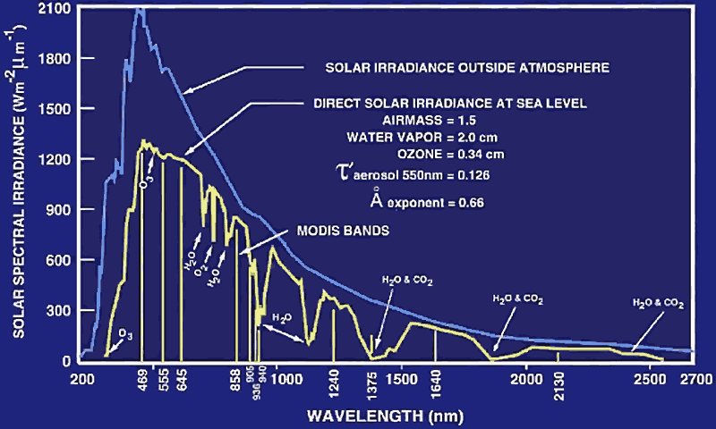
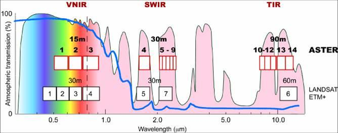
15 Atmospheric windows

16 Atmospheric windows
17 Exercise (in your own time) Spectral Characteristics Viewer "What are the best spectral bands to use for my study?" The spatial resolution most interesting aspect of a satellite image, but less appreciated is how irradiative energy reflected by surface materials are used to identify features. The Spectral Characteristics Viewer allows viewers to visualize how the bands of various satellite sensors measure the intensity of the wavelengths (colors) of light; this is called the Relative Spectral Response (RSR). By overlaying the spectral curves from different spectra (features), the user can determine which bands of the selected sensor(s) will work for the application. Relative Spectral Responses (RSR) for Landsat sensors can be found on
18 Physical Basis of Remote Sensing Radiant energy - Q Energy traveling in the form of electromagnetic waves. Radiant flux - F units: watts units: joules (J) (W [joules/second]) The rate at which radiant energy is transferred from a point or a surface to another surface; a measure of radiant power. F = dq / dt [F = Phi ]
19 Physical Basis of Remote Sensing Radiant flux density - E or M units: watts per sq. meter, W m -2 The radiant flux at a surface divided by the area of the surface. When referring to the radiant flux incident on a surface, we call it: Irradiance - E = df / da [W m -2 ] When referring to the radiant flux emitted from a surface, we call it: Radiant exitance - M = df / da [W m -2 ]
20 Physical Basis of Remote Sensing Radiant flux density - E or M Notice that the units and defining equations for both radiant exitance and irradiance are identical. The only difference between these two radiometric terms is that irradiance refers to radiation arriving at a surface, where as radiant exitance refers to radiation leaving a surface.
21 Physical Basis of Remote Sensing Radiance L (E) units: watts per sq. meter per steradian, W m-2 sr -1 Radiant flux propagated in a given direction, per unit solid angle about that direction and per unit area projected normal to the direction (da cos Q). The angle Q is measured between the direction and a perpendicular to the unit area. Radiance is a geometric radiation quantity that describes the spatial distribution of radiant flux density. L = df / dw da cos Q
22 Physical Basis of Remote Sensing Radiance L (E) units: watts per sq. meter per steradian, W m-2 sr -1 L = df / dw da cos Q
23 Physical Basis of Remote Sensing Reflectance r unitless or expressed as a % E / E (E / E ) * 100 [percent reflectance]
24 Physical Basis of Remote Sensing When radiant energy, or any related quantity, is measured in terms of its monochromatic components (i.e. narrow wavelength range) it becomes a function of wavelength. Therefore, the designations for these quantities must be preceded by the adjective spectral, as in spectral irradiance. The symbol for each quantity, is followed by the symbol for wavelength (l). For example, spectral irradiance has the symbol E (l)
25 Physical Basis of Remote Sensing Interaction of Sunlight (E ) with earth features Reflected (r = reflectance) Transmitted (t = transmittance) Absorbed (a = absorptance) E (l) = r (l) + t (l) + a (l) r (l) = (l) - [ t (l) + a (l) ]
 3. Analysis (Step 5 or information extraction) 4.")
26 DIPA Flowchart All you need to know 0. Overview of Remote Sensing 1. Radiometric correction (Step 1,2,3) System radiometric correction Atmospheric correction Bidirectional correction 2. Geometric registration (Step 4) 3. Analysis (Step 5 or information extraction) 4. Application (Step 6) Application Analysis Digital Numbers Step 1 Step 2 Radiance TOA Reflectance Step 3 Surface Reflectance Step 4 Geometric correction
27 DIPA Flowchart All you need to know Data / Images Information Knowledge Acquisition, Quality control, Processing, Georectification. Theory, Techniques Modeling Implementation Interpretation Presentation
28 Terms and Functions in DIPA Important Terms Spatial Resolution Radiometric Resolution Temporal Resolution Spectral Resolution Processing Radiometric Correction Geometric Correction Display & Enhancement Information Extraction
29 Corrections 1. Radiometric Correction 1.1 System Radiometric Correction
30 DIPA Flowchart 1. Radiometric correction (Step 1,2,3) System radiometric correction Atmospheric correction Bidirectional correction 2. Geometric registration (Step 4) 3. Analysis (Step 5 or information extraction) How to do this? Take Landsat as an example Analysis Digital Numbers Step 1 Step 2 Radiance TOA Reflectance Step 3 Surface Reflectance Step 4 Geometric correction
31 Sun Solar irradiance can be computed in theory Solar constant as suggested by Frohlich (1977): 1373±20 W/m 2, and by Forgan (1977): 1375±21 W/m 2 Exercise 03: What is the solar irradiance within the spectral regions of Enhanced Landsat Thematic Mapper Plus (or ETM+) Sensor? Find them out and list them in a table in either XLS or WORD or pdf format. Send it via on Angel system
32 Sun Solar irradiance at the top of atmosphere Exo-atmosphere irradiance (Eo) Irradiance is attenuated by atmosphere when the Eo reaches to the earth surface To account for atmospheric effect, then, we need to know the properties of atmosphere Transmission and absorption
33 Key Concepts BRDF Bidirectional Reflectance Distribution Function The fundamental and intrinsic property governing the reflectance behavior of a scene element is its bidirectional reflectance distribution function, or BRDF. The integration of this quantity over finite solid angles of incidence and exitance yields the reflectance factor that is actually estimated in most field measurements. However, multidirectional (omnidirectional) field radiance measurements of sufficient angular density can also provide useful estimates of the BRDF
34 Key Concepts Reflectance Factor: Reflectance factor is defined as the ratio of the radiant flux actually reflected by a sample surface to that which would be reflected into the same reflected-beam geometry by an ideal (lossless, that is, 100% reflectivity) perfectly diffuse (Lambertian) standard surface irradiated in exactly the same way as the sample.
35 Key Concepts Conical Reflectance Factor: is defined as the ratio of conical reflected flux to that of hemispherical incident radiant flux. Bidirectional Reflectance Factor, sometimes simply called reflectance factor, is defined as the target surface radiance divided by the radiance of a level reference surface standard irradiated by the sun. For small fields of view (angle of acceptance, < 20 o ), this term is appropriate with one direction being associated with the viewing angle and the other direction being associated with the solar zenith and azimuth angles. The bidirectional reflectance is frequently used rather loosely to refer to the bidirectional reflectance factor(s) measured over targets from one or more nadir and off-nadir viewing angles.
36 Key Concepts Albedo is defined as the ratio of the total solar flux reflected in all directions to the incident solar flux. It is an integral value over all wavelengths. Integration of bidirectional reflectance factors over all angles will yield albedo.
37 Radiometry The Inverse Square Law The inverse square law defines the relationship between the irradiance from a point source and distance. It states that the intensity per unit area varies in inverse proportion to the square of the distance. E = I / d 2 If you measure 16 W cm -2 at 1 meter, you will measure 4 W cm -2 at 2 meters.
38 Radiometry The Inverse Square Law An alternative form is often more convenient: E 1 d 1 2 = E2 d 2 2 Distance is measured to the first luminating surface Normal To da P d d da
39 Radiometry Lambert s Cosine Law The irradiance falling on any surface varies as a function of the cosine of the incident angle,. The perceived measurement area orthogonal to the incident flux is reduced at oblique angles, causing light to spread out over a wider area than it would if perpendicular to the measurement plane.
40 Radiometry Lambert s Cosine Law

41 Radiometry Lambertian Surface A Lambertian surface provides uniform diffusion of the incident radiation such that its radiance is the same in all directions from which it can be measured. A surface radiating equally at 0 and at 60. Since, by the cosine law, a radiance detector sees twice as much surface area in the same solid angle for the 60 case, the average radiance must be half the magnitude of the radiance in the 0 case.
42 Data sources Register and create NASA REVERB ECHO: Most MODIS data products and other EOS Landsat and terrestrial data USGS Earth explorer: USGS GLOVIS:
Treasure Hunt. Lecture 2 How does Light Interact with the Environment? EMR Principles and Properties. EMR and Remote Sensing
 Lecture 2 How does Light Interact with the Environment? Treasure Hunt Find and scan all 11 QR codes Choose one to watch / read in detail Post the key points as a reaction to http://www.scoop.it/t/env202-502-w2
Passive Remote Sensing of Clouds from Airborne Platforms
 Passive Remote Sensing of Clouds from Airborne Platforms Why airborne measurements? My instrument: the Solar Spectral Flux Radiometer (SSFR) Some spectrometry/radiometry basics How can we infer cloud properties
Radiation Transfer in Environmental Science
 Radiation Transfer in Environmental Science with emphasis on aquatic and vegetation canopy media Autumn 2008 Prof. Emmanuel Boss, Dr. Eyal Rotenberg Introduction Radiation in Environmental sciences Most
Electromagnetic Radiation (EMR) and Remote Sensing
 and Remote Sensing") Electromagnetic Radiation (EMR) and Remote Sensing 1 Atmosphere Anything missing in between? Electromagnetic Radiation (EMR) is radiated by atomic particles at the source (the Sun), propagates through
Electromagnetic Radiation (EMR) and Remote Sensing 1 Atmosphere Anything missing in between? Electromagnetic Radiation (EMR) is radiated by atomic particles at the source (the Sun), propagates through
2 Absorbing Solar Energy
 2 Absorbing Solar Energy 2.1 Air Mass and the Solar Spectrum Now that we have introduced the solar cell, it is time to introduce the source of the energy the sun. The sun has many properties that could
Overview. What is EMR? Electromagnetic Radiation (EMR) LA502 Special Studies Remote Sensing
 LA502 Special Studies Remote Sensing") LA502 Special Studies Remote Sensing Electromagnetic Radiation (EMR) Dr. Ragab Khalil Department of Landscape Architecture Faculty of Environmental Design King AbdulAziz University Room 103 Overview What
LA502 Special Studies Remote Sensing Electromagnetic Radiation (EMR) Dr. Ragab Khalil Department of Landscape Architecture Faculty of Environmental Design King AbdulAziz University Room 103 Overview What
A remote sensing instrument collects information about an object or phenomenon within the
 Satellite Remote Sensing GE 4150- Natural Hazards Some slides taken from Ann Maclean: Introduction to Digital Image Processing Remote Sensing the art, science, and technology of obtaining reliable information
Resolutions of Remote Sensing
 Resolutions of Remote Sensing 1. Spatial (what area and how detailed) 2. Spectral (what colors bands) 3. Temporal (time of day/season/year) 4. Radiometric (color depth) Spatial Resolution describes how
D.S. Boyd School of Earth Sciences and Geography, Kingston University, U.K.
 PHYSICAL BASIS OF REMOTE SENSING D.S. Boyd School of Earth Sciences and Geography, Kingston University, U.K. Keywords: Remote sensing, electromagnetic radiation, wavelengths, target, atmosphere, sensor,
Reprint (R22) Avoiding Errors in UV Radiation Measurements. By Thomas C. Larason July 2001. Reprinted from Photonics Spectra, Laurin Publishing
 Avoiding Errors in UV Radiation Measurements. By Thomas C. Larason July 2001. Reprinted from Photonics Spectra, Laurin Publishing") Reprint (R22) Avoiding Errors in UV Radiation Measurements By Thomas C. Larason July 2001 Reprinted from Photonics Spectra, Laurin Publishing Gooch & Housego 4632 36 th Street, Orlando, FL 32811 Tel: 1
Reprint (R22) Avoiding Errors in UV Radiation Measurements By Thomas C. Larason July 2001 Reprinted from Photonics Spectra, Laurin Publishing Gooch & Housego 4632 36 th Street, Orlando, FL 32811 Tel: 1
Integrating the Solar Spectrum
 Integrating the Solar Spectrum PHYS 4400, Principles and Varieties of Solar Energy Instructor: Randy J. Ellingson The University of Toledo January 24, 203 Pop Quiz Note: quiz does not count toward grade
Solar Energy. Outline. Solar radiation. What is light?-- Electromagnetic Radiation. Light - Electromagnetic wave spectrum. Electromagnetic Radiation
 Outline MAE 493R/593V- Renewable Energy Devices Solar Energy Electromagnetic wave Solar spectrum Solar global radiation Solar thermal energy Solar thermal collectors Solar thermal power plants Photovoltaics
Reflectance Characteristics of Accuflect Light Reflecting Ceramic
 Reflectance Characteristics of Accuflect Light Reflecting Ceramic Copyright July 1 Accuratus Corporation 35 Howard Street Phillipsburg, NJ 8865 USA +1.98.13.77 http://accuratus.com SUMMARY Accuflect is
Review for Introduction to Remote Sensing: Science Concepts and Technology
 Review for Introduction to Remote Sensing: Science Concepts and Technology Ann Johnson Associate Director ann@baremt.com Funded by National Science Foundation Advanced Technological Education program [DUE
Digital Remote Sensing Data Processing Digital Remote Sensing Data Processing and Analysis: An Introduction and Analysis: An Introduction
 Digital Remote Sensing Data Processing Digital Remote Sensing Data Processing and Analysis: An Introduction and Analysis: An Introduction Content Remote sensing data Spatial, spectral, radiometric and
Chapter 2: Solar Radiation and Seasons
 Chapter 2: Solar Radiation and Seasons Spectrum of Radiation Intensity and Peak Wavelength of Radiation Solar (shortwave) Radiation Terrestrial (longwave) Radiations How to Change Air Temperature? Add
Hyperspectral Satellite Imaging Planning a Mission
 Hyperspectral Satellite Imaging Planning a Mission Victor Gardner University of Maryland 2007 AIAA Region 1 Mid-Atlantic Student Conference National Institute of Aerospace, Langley, VA Outline Objective
How to calculate reflectance and temperature using ASTER data
 How to calculate reflectance and temperature using ASTER data Prepared by Abduwasit Ghulam Center for Environmental Sciences at Saint Louis University September, 2009 This instructions walk you through
Solar Radiation Measurement. Bruce W Forgan, WMO RAV Metrology Workshop, Melbourne, Novemberr 2011
 Solar Radiation Measurement Bruce W Forgan, WMO RAV Metrology Workshop, Melbourne, Novemberr 2011 Why Do We Need Data on Solar Energy? Global Climate System Climate Energy Balance Solar Exposure and Irradiance
Myths and misconceptions about remote sensing
 Myths and misconceptions about remote sensing Ned Horning (graphics support - Nicholas DuBroff) Version: 1.0 Creation Date: 2004-01-01 Revision Date: 2004-01-01 License: This document is licensed under
-1- Electromagnetic radiation (EMR) basics for remote sensing
 basics for remote sensing") -1- Electromagnetic radiation (EMR) basics for remote sensing HANDOUT s OBJECTIVES: familiarize student with basic EMR terminology & mathematics overview of EMR polarization as related to remote sensing
-1- Electromagnetic radiation (EMR) basics for remote sensing HANDOUT s OBJECTIVES: familiarize student with basic EMR terminology & mathematics overview of EMR polarization as related to remote sensing
CHAPTER 2 Energy and Earth
 CHAPTER 2 Energy and Earth This chapter is concerned with the nature of energy and how it interacts with Earth. At this stage we are looking at energy in an abstract form though relate it to how it affect
Energy Pathways in Earth s Atmosphere
 BRSP - 10 Page 1 Solar radiation reaching Earth s atmosphere includes a wide spectrum of wavelengths. In addition to visible light there is radiation of higher energy and shorter wavelength called ultraviolet
Take away concepts. What is Energy? Solar Energy. EM Radiation. Properties of waves. Solar Radiation Emission and Absorption
 Take away concepts Solar Radiation Emission and Absorption 1. 2. 3. 4. 5. 6. Conservation of energy. Black body radiation principle Emission wavelength and temperature (Wein s Law). Radiation vs. distance
Geography 403 Lecture 7 Scanners, Thermal, and Microwave
 Geography 403 Lecture 7 Scanners, Thermal, and Microwave Needs: Lect_403_7.ppt A. Basics of Passive Electric Sensors 1. Sensors absorb EMR and produce some sort of response, such as voltages differences
2.3 Spatial Resolution, Pixel Size, and Scale
 Section 2.3 Spatial Resolution, Pixel Size, and Scale Page 39 2.3 Spatial Resolution, Pixel Size, and Scale For some remote sensing instruments, the distance between the target being imaged and the platform,
Examples of Uniform EM Plane Waves
 Examples of Uniform EM Plane Waves Outline Reminder of Wave Equation Reminder of Relation Between E & H Energy Transported by EM Waves (Poynting Vector) Examples of Energy Transport by EM Waves 1 Coupling
Solar Flux and Flux Density. Lecture 3: Global Energy Cycle. Solar Energy Incident On the Earth. Solar Flux Density Reaching Earth
 Lecture 3: Global Energy Cycle Solar Flux and Flux Density Planetary energy balance Greenhouse Effect Vertical energy balance Latitudinal energy balance Seasonal and diurnal cycles Solar Luminosity (L)
P.M. Rich, W.A. Hetrick, S.C. Saving Biological Sciences University of Kansas Lawrence, KS 66045
 USING VIEWSHED MODELS TO CALCULATE INTERCEPTED SOLAR RADIATION: APPLICATIONS IN ECOLOGY by P.M. Rich, W.A. Hetrick, S.C. Saving Biological Sciences University of Kansas Lawrence, KS 66045 R.O. Dubayah
Corso di Fisica Te T cnica Ambientale Solar Radiation
 Solar Radiation Solar radiation i The Sun The Sun is the primary natural energy source for our planet. It has a diameter D = 1.39x10 6 km and a mass M = 1.989x10 30 kg and it is constituted by 1/3 of He
Blackbody radiation. Main Laws. Brightness temperature. 1. Concepts of a blackbody and thermodynamical equilibrium.
 Lecture 4 lackbody radiation. Main Laws. rightness temperature. Objectives: 1. Concepts of a blackbody, thermodynamical equilibrium, and local thermodynamical equilibrium.. Main laws: lackbody emission:
High Resolution Information from Seven Years of ASTER Data
 High Resolution Information from Seven Years of ASTER Data Anna Colvin Michigan Technological University Department of Geological and Mining Engineering and Sciences Outline Part I ASTER mission Terra
PTYS/ASTR 206 Section 2 Spring 2007 Homework #2 (Page 1/5) NAME: KEY
 NAME: KEY") PTYS/ASTR 206 Section 2 Spring 2007 Homework #2 (Page 1/5) NAME: KEY Due Date: start of class 2/6/2007 5 pts extra credit if turned in before 9:00AM (early!) (To get the extra credit, the assignment must
PTYS/ASTR 206 Section 2 Spring 2007 Homework #2 (Page 1/5) NAME: KEY Due Date: start of class 2/6/2007 5 pts extra credit if turned in before 9:00AM (early!) (To get the extra credit, the assignment must
Lectures Remote Sensing
 Lectures Remote Sensing ATMOSPHERIC CORRECTION dr.ir. Jan Clevers Centre of Geo-Information Environmental Sciences Wageningen UR Atmospheric Correction of Optical RS Data Background When needed? Model
SAMPLE MIDTERM QUESTIONS
 Geography 309 Sample MidTerm Questions Page 1 SAMPLE MIDTERM QUESTIONS Textbook Questions Chapter 1 Questions 4, 5, 6, Chapter 2 Questions 4, 7, 10 Chapter 4 Questions 8, 9 Chapter 10 Questions 1, 4, 7
Lecture on Solid Angle
 Lecture on Solid Angle Ben Kravitz 1 Introduction The idea of a solid angle comes up a lot in remote sensing applications, so it s important that you know what it is. As such, I ve made this lecture for
How Landsat Images are Made
 How Landsat Images are Made Presentation by: NASA s Landsat Education and Public Outreach team June 2006 1 More than just a pretty picture Landsat makes pretty weird looking maps, and it isn t always easy
The Surface Energy Budget
 The Surface Energy Budget The radiation (R) budget Shortwave (solar) Radiation Longwave Radiation R SW R SW α α = surface albedo R LW εσt 4 ε = emissivity σ = Stefan-Boltzman constant T = temperature Subsurface
Specific Intensity. I ν =
 Specific Intensity Initial question: A number of active galactic nuclei display jets, that is, long, nearly linear, structures that can extend for hundreds of kiloparsecs. Many have two oppositely-directed
Principle of Thermal Imaging
 Section 8 All materials, which are above 0 degrees Kelvin (-273 degrees C), emit infrared energy. The infrared energy emitted from the measured object is converted into an electrical signal by the imaging
LECTURE N 3. - Solar Energy and Solar Radiation- IDES-EDU
 LECTURE N 3 - Solar Energy and Solar Radiation- Lecture contributions Coordinator & contributor of the lecture: Prof. Marco Perino, DENERG Politecnico di Torino, C.so Duca degli Abruzzi 24, 10129 Torino,
The Phenomenon of Photoelectric Emission:
 The Photoelectric Effect. The Wave particle duality of light Light, like any other E.M.R (electromagnetic radiation) has got a dual nature. That is there are experiments that prove that it is made up of
Light Control and Efficacy using Light Guides and Diffusers
 Light Control and Efficacy using Light Guides and Diffusers LEDs 2012 Michael Georgalis, LC Marketing Manager, Fusion Optix October 11, 2012 Agenda Introduction What Is Light Control? Improves Application
The Physics of Energy sources Renewable sources of energy. Solar Energy
 The Physics of Energy sources Renewable sources of energy Solar Energy B. Maffei Bruno.maffei@manchester.ac.uk Renewable sources 1 Solar power! There are basically two ways of using directly the radiative
SOLAR RADIATION AND YIELD. Alessandro Massi Pavan
 SOLAR RADIATION AND YIELD Alessandro Massi Pavan Sesto Val Pusteria June 22 nd 26 th, 2015 DEFINITIONS Solar radiation: general meaning Irradiation [Wh/m 2 ]: energy received per unit area Irradiance [W/m
W E B R I N G Q U A L I T Y T O L I G H T. Handbook of LED Metrology
 W E B R I N G Q U A L I T Y T O L I G H T. Handbook of LED Metrology LED Metrology Contents Page 1. Introduction 2 2. Terms and Definitions in Photometry and Colorimetry 3 2.1 Radiometric quantities 3
INVESTIGA I+D+i 2013/2014
 INVESTIGA I+D+i 2013/2014 SPECIFIC GUIDELINES ON AEROSPACE OBSERVATION OF EARTH Text by D. Eduardo de Miguel October, 2013 Introducction Earth observation is the use of remote sensing techniques to better
Experiment #5: Qualitative Absorption Spectroscopy
 Experiment #5: Qualitative Absorption Spectroscopy One of the most important areas in the field of analytical chemistry is that of spectroscopy. In general terms, spectroscopy deals with the interactions
where h = 6.62 10-34 J s
 Electromagnetic Spectrum: Refer to Figure 12.1 Molecular Spectroscopy: Absorption of electromagnetic radiation: The absorptions and emissions of electromagnetic radiation are related molecular-level phenomena
5. The Nature of Light. Does Light Travel Infinitely Fast? EMR Travels At Finite Speed. EMR: Electric & Magnetic Waves
 5. The Nature of Light Light travels in vacuum at 3.0. 10 8 m/s Light is one form of electromagnetic radiation Continuous radiation: Based on temperature Wien s Law & the Stefan-Boltzmann Law Light has
16 th IOCCG Committee annual meeting. Plymouth, UK 15 17 February 2011. mission: Present status and near future
 16 th IOCCG Committee annual meeting Plymouth, UK 15 17 February 2011 The Meteor 3M Mt satellite mission: Present status and near future plans MISSION AIMS Satellites of the series METEOR M M are purposed
ESCI-61 Introduction to Photovoltaic Technology. Solar Radiation. Ridha Hamidi, Ph.D.
 1 ESCI-61 Introduction to Photovoltaic Technology Solar Radiation Ridha Hamidi, Ph.D. 2 The Sun The Sun is a perpetual source of energy It has produced energy for about 4.6 billions of years, and it is
What is Solar Control?
 A better environment inside and out. Solar, Safety and Security Window Films: Tech Bulletin Understanding Solar Performance Solar Gard solar control window films use advanced technology to benefit consumers
Digital image processing
 746A27 Remote Sensing and GIS Lecture 4 Digital image processing Chandan Roy Guest Lecturer Department of Computer and Information Science Linköping University Digital Image Processing Most of the common
Various Technics of Liquids and Solids Level Measurements. (Part 3)
") (Part 3) In part one of this series of articles, level measurement using a floating system was discusses and the instruments were recommended for each application. In the second part of these articles,
(Part 3) In part one of this series of articles, level measurement using a floating system was discusses and the instruments were recommended for each application. In the second part of these articles,
Optical Design Tools for Backlight Displays
 Optical Design Tools for Backlight Displays Introduction Backlights are used for compact, portable, electronic devices with flat panel Liquid Crystal Displays (LCDs) that require illumination from behind.
Table 1 r (m) I (W/m 2 ) 0.10 477.46 0.20 119.37 0.50 19.10 1.00 4.77 2.00 1.19 5.00 0.19 10.00 0.05 Table 2: Intensities at 1-m Distances Power (W)
 I (W/m 2 ) 0.10 477.46 0.20 119.37 0.50 19.10 1.00 4.77 2.00 1.19 5.00 0.19 10.00 0.05 Table 2: Intensities at 1-m Distances Power (W)") Light Intensity The term intensity is used to describe the rate at which light spreads over a surface of a given area some distance from a source. The intensity varies with the distance from the source
Light Intensity The term intensity is used to describe the rate at which light spreads over a surface of a given area some distance from a source. The intensity varies with the distance from the source
ATM S 111, Global Warming: Understanding the Forecast
 ATM S 111, Global Warming: Understanding the Forecast DARGAN M. W. FRIERSON DEPARTMENT OF ATMOSPHERIC SCIENCES DAY 1: OCTOBER 1, 2015 Outline How exactly the Sun heats the Earth How strong? Important concept
The USGS Landsat Big Data Challenge
 The USGS Landsat Big Data Challenge Brian Sauer Engineering and Development USGS EROS bsauer@usgs.gov U.S. Department of the Interior U.S. Geological Survey USGS EROS and Landsat 2 Data Utility and Exploitation
Chapter Contents Page No
 Chapter Contents Page No Preface Acknowledgement 1 Basics of Remote Sensing 1 1.1. Introduction 1 1.2. Definition of Remote Sensing 1 1.3. Principles of Remote Sensing 1 1.4. Various Stages in Remote Sensing
Optical Communications
 Optical Communications Telecommunication Engineering School of Engineering University of Rome La Sapienza Rome, Italy 2005-2006 Lecture #2, May 2 2006 The Optical Communication System BLOCK DIAGRAM OF
CS 431/636 Advanced Rendering Techniques"
 CS 431/636 Advanced Rendering Techniques" Dr. David Breen" Korman 105D" Wednesday 6PM 8:50PM" Photon Mapping" 5/2/12" Slide Credits - UC San Diego Goal Efficiently create global illumination images with
DOING PHYSICS WITH MATLAB COMPUTATIONAL OPTICS RAYLEIGH-SOMMERFELD DIFFRACTION INTEGRAL OF THE FIRST KIND
 DOING PHYSICS WITH MATLAB COMPUTATIONAL OPTICS RAYLEIGH-SOMMERFELD DIFFRACTION INTEGRAL OF THE FIRST KIND THE THREE-DIMENSIONAL DISTRIBUTION OF THE RADIANT FLUX DENSITY AT THE FOCUS OF A CONVERGENCE BEAM
Physics Notes Class 11 CHAPTER 2 UNITS AND MEASUREMENTS
 1 P a g e Physics Notes Class 11 CHAPTER 2 UNITS AND MEASUREMENTS The comparison of any physical quantity with its standard unit is called measurement. Physical Quantities All the quantities in terms of
Waves - Transverse and Longitudinal Waves
 Waves - Transverse and Longitudinal Waves wave may be defined as a periodic disturbance in a medium that carries energy from one point to another. ll waves require a source and a medium of propagation.
Reflectance Measurements of Materials Used in the Solar Industry. Selecting the Appropriate Accessories for UV/Vis/NIR Measurements.
 T e c h n i c a l N o t e Reflectance Measurements of Materials Used in the Solar Industry UV/Vis/NIR Author: Dr. Jeffrey L. Taylor PerkinElmer, Inc. 710 Bridgeport Avenue Shelton, CT 06484 USA Selecting
Development of Optical Wave Microphone Measuring Sound Waves with No Diaphragm
 Progress In Electromagnetics Research Symposium Proceedings, Taipei, March 5 8, 3 359 Development of Optical Wave Microphone Measuring Sound Waves with No Diaphragm Yoshito Sonoda, Takashi Samatsu, and
Full credit for this chapter to Prof. Leonard Bachman of the University of Houston
 Chapter 6: SOLAR GEOMETRY Full credit for this chapter to Prof. Leonard Bachman of the University of Houston SOLAR GEOMETRY AS A DETERMINING FACTOR OF HEAT GAIN, SHADING AND THE POTENTIAL OF DAYLIGHT PENETRATION...
Tech Bulletin. Understanding Solar Performance
 Tech Bulletin Understanding Solar Performance Bekaert solar control window films use advanced technology to benefit consumers with quality solutions that enhance comfort and decrease energy use. By understanding
Understanding Range for RF Devices
 Understanding Range for RF Devices October 2012 White Paper Understanding how environmental factors can affect range is one of the key aspects to deploying a radio frequency (RF) solution. This paper will
Lake Monitoring in Wisconsin using Satellite Remote Sensing
 Lake Monitoring in Wisconsin using Satellite Remote Sensing D. Gurlin and S. Greb Wisconsin Department of Natural Resources 2015 Wisconsin Lakes Partnership Convention April 23 25, 2105 Holiday Inn Convention
Energy Transport. Focus on heat transfer. Heat Transfer Mechanisms: Conduction Radiation Convection (mass movement of fluids)
") Energy Transport Focus on heat transfer Heat Transfer Mechanisms: Conduction Radiation Convection (mass movement of fluids) Conduction Conduction heat transfer occurs only when there is physical contact
Energy Transport Focus on heat transfer Heat Transfer Mechanisms: Conduction Radiation Convection (mass movement of fluids) Conduction Conduction heat transfer occurs only when there is physical contact
Theremino System Theremino Spectrometer Technology
 Theremino System Theremino Spectrometer Technology theremino System - Theremino Spectrometer Technology - August 15, 2014 - Page 1 Operation principles By placing a digital camera with a diffraction grating
Remote sensing is the collection of data without directly measuring the object it relies on the
 Chapter 8 Remote Sensing Chapter Overview Remote sensing is the collection of data without directly measuring the object it relies on the reflectance of natural or emitted electromagnetic radiation (EMR).
Advanced Computer Graphics. Rendering Equation. Matthias Teschner. Computer Science Department University of Freiburg
 Advanced Computer Graphics Rendering Equation Matthias Teschner Computer Science Department University of Freiburg Outline rendering equation Monte Carlo integration sampling of random variables University
a) species of plants that require a relatively cool, moist environment tend to grow on poleward-facing slopes.
 species of plants that require a relatively cool, moist environment tend to grow on poleward-facing slopes.") J.D. McAlpine ATMS 611 HMWK #8 a) species of plants that require a relatively cool, moist environment tend to grow on poleward-facing slopes. These sides of the slopes will tend to have less average solar
J.D. McAlpine ATMS 611 HMWK #8 a) species of plants that require a relatively cool, moist environment tend to grow on poleward-facing slopes. These sides of the slopes will tend to have less average solar
Physics 6C, Summer 2006 Homework 2 Solutions
 Physics 6C, Summer 006 Homework Solutions All problems are from the nd edition of Walker. Numerical values are different for each student. Chapter 3 Problems. Figure 3-30 below shows a circuit containing
Fundamentals of modern UV-visible spectroscopy. Presentation Materials
 Fundamentals of modern UV-visible spectroscopy Presentation Materials The Electromagnetic Spectrum E = hν ν = c / λ 1 Electronic Transitions in Formaldehyde 2 Electronic Transitions and Spectra of Atoms
Digital Image Fundamentals. Selim Aksoy Department of Computer Engineering Bilkent University saksoy@cs.bilkent.edu.tr
 Digital Image Fundamentals Selim Aksoy Department of Computer Engineering Bilkent University saksoy@cs.bilkent.edu.tr Imaging process Light reaches surfaces in 3D. Surfaces reflect. Sensor element receives
PHYS 222 Spring 2012 Final Exam. Closed books, notes, etc. No electronic device except a calculator.
 PHYS 222 Spring 2012 Final Exam Closed books, notes, etc. No electronic device except a calculator. NAME: (all questions with equal weight) 1. If the distance between two point charges is tripled, the
Sunlight and its Properties. EE 495/695 Y. Baghzouz
 Sunlight and its Properties EE 495/695 Y. Baghzouz The sun is a hot sphere of gas whose internal temperatures reach over 20 million deg. K. Nuclear fusion reaction at the sun's core converts hydrogen to
After a wave passes through a medium, how does the position of that medium compare to its original position?
 Light Waves Test Question Bank Standard/Advanced Name: Question 1 (1 point) The electromagnetic waves with the highest frequencies are called A. radio waves. B. gamma rays. C. X-rays. D. visible light.
Physical Science Study Guide Unit 7 Wave properties and behaviors, electromagnetic spectrum, Doppler Effect
 Objectives: PS-7.1 Physical Science Study Guide Unit 7 Wave properties and behaviors, electromagnetic spectrum, Doppler Effect Illustrate ways that the energy of waves is transferred by interaction with
Landsat Monitoring our Earth s Condition for over 40 years
 Landsat Monitoring our Earth s Condition for over 40 years Thomas Cecere Land Remote Sensing Program USGS ISPRS:Earth Observing Data and Tools for Health Studies Arlington, VA August 28, 2013 U.S. Department
Table of Contents. An Introduction to Hyperspectral Imaging Technology
 Table of Contents 1.0 Introduction... 1 2.0 Electromagnetic Radiation... 1 2.1 The Electromagnetic Spectrum... 2 2.2 Electromagnetic Interactions with Matter... 3 3.0 Spectroscopy... 5 3.1 Refraction and
GEOG 579 - Remote Sensing 76634-001
 GEOG 579 - Remote Sensing 76634-001 Syllabus Instructor: Dr. Ron Resmini Course description and objective: GEOG 579, Remote Sensing, will provide graduate students with the concepts, principles, and methods
SOLAR ENERGY How much strikes the earth? How much can my building get? When is it too much?
 SOLAR ENERGY How much strikes the earth? How much can my building get? When is it too much? The sun: friend of foe? Drawing by Le Corbusier ENGS 44 Sustainable Design Benoit Cushman-Roisin 14 April 2015
Path Tracing. Michael Doggett Department of Computer Science Lund university. 2012 Michael Doggett
 Path Tracing Michael Doggett Department of Computer Science Lund university 2012 Michael Doggett Outline Light transport notation Radiometry - Measuring light Illumination Rendering Equation Monte Carlo
Development of Method for LST (Land Surface Temperature) Detection Using Big Data of Landsat TM Images and AWS
 Detection Using Big Data of Landsat TM Images and AWS") Development of Method for LST (Land Surface Temperature) Detection Using Big Data of Landsat TM Images and AWS Myung-Hee Jo¹, Sung Jae Kim², Jin-Ho Lee 3 ¹ Department of Aeronautical Satellite System Engineering,
Development of Method for LST (Land Surface Temperature) Detection Using Big Data of Landsat TM Images and AWS Myung-Hee Jo¹, Sung Jae Kim², Jin-Ho Lee 3 ¹ Department of Aeronautical Satellite System Engineering,
ENVI Classic Tutorial: Atmospherically Correcting Multispectral Data Using FLAASH 2
 ENVI Classic Tutorial: Atmospherically Correcting Multispectral Data Using FLAASH Atmospherically Correcting Multispectral Data Using FLAASH 2 Files Used in this Tutorial 2 Opening the Raw Landsat Image
LiDAR for vegetation applications
 LiDAR for vegetation applications UoL MSc Remote Sensing Dr Lewis plewis@geog.ucl.ac.uk Introduction Introduction to LiDAR RS for vegetation Review instruments and observational concepts Discuss applications
The Sun. Solar radiation (Sun Earth-Relationships) The Sun. The Sun. Our Sun
 The Sun. The Sun. Our Sun") The Sun Solar Factoids (I) The sun, a medium-size star in the milky way galaxy, consisting of about 300 billion stars. (Sun Earth-Relationships) A gaseous sphere of radius about 695 500 km (about 109 times
The Sun Solar Factoids (I) The sun, a medium-size star in the milky way galaxy, consisting of about 300 billion stars. (Sun Earth-Relationships) A gaseous sphere of radius about 695 500 km (about 109 times
Antenna Properties and their impact on Wireless System Performance. Dr. Steven R. Best. Cushcraft Corporation 48 Perimeter Road Manchester, NH 03013
 Antenna Properties and their impact on Wireless System Performance Dr. Steven R. Best Cushcraft Corporation 48 Perimeter Road Manchester, NH 03013 Phone (603) 627-7877 FAX: (603) 627-1764 Email: sbest@cushcraft.com
Overview of the IR channels and their applications
 Ján Kaňák Slovak Hydrometeorological Institute Jan.kanak@shmu.sk Overview of the IR channels and their applications EUMeTrain, 14 June 2011 Ján Kaňák, SHMÚ 1 Basics in satellite Infrared image interpretation
Green Heating. Pupil Research Brief. Teachers Notes. Syllabus Coverage Subject Knowledge and Understanding. Route through the Brief UPIL ESEARCHER
 R P UPIL ESEARCHER Green Heating I NITIATIVE Pupil Research Brief Teachers Notes Syllabus Coverage Subject Knowledge and Understanding all types of electromagnetic radiation form a continuous spectrum
BRDF, BRF and HDRF in the Revised Manuscript
 Atmos. Chem. Phys. Discuss., 11, C13026 C13047, 2011 www.atmos-chem-phys-discuss.net/11/c13026/2011/ Author(s) 2011. This work is distributed under the Creative Commons Attribute 3.0 License. Atmospheric
PHOTON mapping is a practical approach for computing global illumination within complex
 7 The Photon Mapping Method I get by with a little help from my friends. John Lennon, 1940 1980 PHOTON mapping is a practical approach for computing global illumination within complex environments. Much
Chemistry 111 Lab: Intro to Spectrophotometry Page E-1
 Chemistry 111 Lab: Intro to Spectrophotometry Page E-1 SPECTROPHOTOMETRY Absorption Measurements & their Application to Quantitative Analysis study of the interaction of light (or other electromagnetic
Remote Sensing. Vandaag. Voordelen Remote Sensing Wat is Remote Sensing? Vier elementen Remote Sensing systeem
 Remote Sensing 1 Vandaag Voordelen Remote Sensing Wat is Remote Sensing? Vier elementen Remote Sensing systeem 2 Nederland Vanaf 700 km hoogte Landsat TM mozaïek 3 Europa vanaf 36000 km hoogte 4 5 Mount
Robot Perception Continued
 Robot Perception Continued 1 Visual Perception Visual Odometry Reconstruction Recognition CS 685 11 Range Sensing strategies Active range sensors Ultrasound Laser range sensor Slides adopted from Siegwart