LONDON BOROUGH OF CAMDEN
|
|
|
- Mae Sullivan
- 10 years ago
- Views:
Transcription
1 LONDON BOROUGH OF CAMDEN Planning Brief for Denmark Place ADOPTED July 2004

2
3 Contents Part 1 Part 2 Part 3 Part 4 Part 5 Part 6 Part 7 Introduction The Site Site Description Ownership and Occupancy Setting Conservation Areas and Listed Buildings Views Transport and Local Circulation Covent Garden Neighbourhood Renewal Area Other Site Constraints Planning Background The Unitary Development Plan Draft London Plan Tottenham Court Road Station and St Giles High Street Area Planning Framework Planning History Development Objectives The Strengths and Weaknesses of the Site Key Objectives Sustainable Development Community Safety Land Use Objectives Mixed-Use Development Housing Employment and Regeneration Retail, Food and Drink Other Uses Public Space Permeability and The Public Realm Permeability and The Public Realm Public Spaces Pedestrian Routes Urban Design Guidance General Principles Demolition of Buildings in the Conservation Area Refurbishment of Denmark Street Properties Planning the Site - General The Public Realm St Giles High Street Frontage Denmark Place Planning Brief Adopted July 2004

4 Andrew Borde Street Frontage Relationship to Existing Buildings Building scale Materials and Detailing Designing Out Crime Part 8 Part 9 Circulation, Access and Servicing Public Transport Connections Transport Impact Statement and Green Travel Plan Access to the Site Parking Implementation Phased Development Checklist of Requirements for Submission of a Planning Application Management of Construction Planning Obligations Appendix 1 Relevant UDP policies Appendix 2 Characteristics of sustainable building Denmark Place Planning Brief Adopted July 2004

5 Part 1 Introduction 1.1 This brief has been prepared to ensure a comprehensive approach to the development of land at Denmark Place. Its purpose is to secure development which accords with the Council s planning objectives, and maximises the benefits of development, which may be undertaken in phases. 1.2 This brief accords with the statutory planning framework established by Camden s Unitary Development Plan adopted in March 2000 and subsequent alterations and it reflects relevant Government advice and circulars. It does not take account of any covenants or similar restrictions which may affect the site. 1.3 Having been subjected to public consultation and endorsed by the Executive of the Council this brief carries the status of Supplementary Planning Guidance. This means that it will be a material consideration in determining planning applications affecting the site. 1.4 Concurrently with drafting this brief, the Council has prepared an Area Planning Framework for the wider Tottenham Court Road Station and St Giles High Street Area in which this site lies and this brief has been written to be conform with this framework. Having been adopted by the Council, this framework also has Supplementary Planning Guidance Status, and any development proposals affecting the site should also be consistent with the framework. 1.5 While in most cases the brief refers to the Council s planning policies in its UDP adopted in March 2000, in some cases it also reflects emerging policies set down in the replacement UDP, for which the second deposit draft was published in May The Council has begun to apply some policies from this draft for development control purposes. 1.6 The brief also takes account of three recent studies of the St Giles Area: In 1998 Land Use Consultants was commissioned by English Heritage working in partnership with Camden and Westminster Councils, GoL, LPAC, London Transport and MEPC who at that time owned Centre Point, to examine opportunities to improve the environment around St Giles Circus and Princes Circus. Land Use Consultants published their recommendations in a two volume study entitled St Giles and Princes Circus Urban Quality Project. In 2000 Camden Council commissioned Intelligent Space to report on Pedestrian Movements in St Giles Circus A March 2000 Report by Space Syntax, entitled Princes Circus: Report on the Strategic Redesign Study. This study was commissioned by the London Borough of Camden to develop new public space designs for Princes Circus. Denmark Place Planning Brief Adopted July

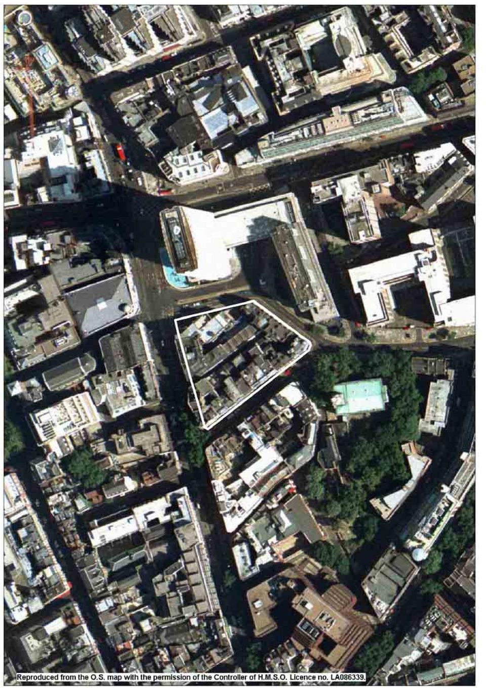
6 Part 2 The Site Site Description 2.1 The Denmark Place site occupies an irregular quadrilateral of land bordered by Denmark Street, Charing Cross Road, Andrew Borde Street and St Giles High Street. Denmark Place, a pedestrian alley cuts through the centre of the site from east to west, and divides it into two parcels of similar size. 2.2 The entire site is almost 4000m 2 in extent and it accommodates several dozen individual buildings that date from different periods and are used for a variety of purposes. These are described briefly in the paragraphs below. 2.3 On the north west corner of the site stands a row of Victorian buildings that face onto Charing Cross Road. These are four storeys high and accommodate retail uses on the ground floor and short tenancy office uses above. Having been acquired by the Greater London Council (GLC) during the 1960s for road widening, these properties have been allowed to lapse into disrepair and are now in poor condition. The flank walls of the buildings have been left exposed on the northern frontage fronting Andrew Borde Street, by the Centre Point traffic system of the 1960s. These walls are now covered by advertisement hoardings and present an unattractive face to this busy area. 2.4 On the north east corner, at St Giles High Street stand two Victorian residential buildings known as York and Clifton Mansions. These are four storeys high with roof mansards and they accommodate retail and restaurant uses on the ground floor and flats above that have recently been reoccupied after lying vacant for many years. These buildings are also in disrepair and as long ago as 1987 they were subject to a resolution by Camden Council for acquisition by compulsory purchase in order to upgrade the flats. 2.5 Next door to Clifton Mansions, towards the south east corner of the site is 59 St Giles High Street, a four storey listed Georgian house. Beyond this, and continuing around the corner into Denmark Street is a row of 4 and 5 storey buildings from different periods that extend through to Denmark Place at the rear. These contain retail and restaurant uses with B1 and residential uses above. Three of these properties are listed. 2.6 In the south west corner of the site, at 126 to 136 Charing Cross Road stands Sheldon Mansions, a 6 storey Edwardian gabled mansion block with ground floor retail use and residential above. 2.7 Denmark Place, the pedestrian alley running through the site, contains the rear entrances to many of the buildings that have already been described, plus, towards the eastern end, a number of individual mews buildings 3 or 4 storeys high. The main entrance into the alley is off Charing Cross Road and at the eastern end there is a narrow covered exit through to St Giles High Street and another onto Denmark Street. Denmark Place has Denmark Place Planning Brief Adopted July

7 inadequate public surveillance and in recent years it has suffered from unsociable behaviour. To address these problems all entrances to it are to be closed after dark. Map 1: The Denmark Place Site 2.8 Records indicate there to be a total of approximately 14000m 2 floorspace on the site. In 1992, when the site was last surveyed in detail, the main uses with their approximate floor areas were found to be as follows: B1 Office 7,530m 2 A1/A2/A3 Ground floor only 2,000 A1/A2/A3 Storage/ancillary 1,905 C3 Residential 3,325 D1 Surgery 64 The gross existing plot ratio is approximately 3.5: Denmark Street itself is locally known as Tin Pan Alley and is renowned as an important centre of the UK popular music industry. Over the years it has attracted specialist retailers, first in music publishing and more recently in the sale and repair of pop music instruments, particularly guitars, keyboards and percussion instruments. Away from the street frontages there are recording studios and some clubs. The street has acquired a unique interest through the presence of these businesses. The small shops, several housed in listed Denmark Place Planning Brief Adopted July

8 buildings, are stacked, sometimes to two or more floors with pop music paraphernalia. They provide noticeboards where groups advertise vacancies and musicians their availability. The Rolling Stones recorded their first album at No 4 Denmark Street. The Beatles signed their first record deal at Dick James Music where Northern Songs the Beatles music publishers were located. Elton John wrote his first hit single on the roof of this building. Joan Armatrading s handprints are set in the shop front of Rose Morris at No 11. Ownership and Occupancy 2.10 This site is owned by Lawrence Kirschel s Consolidated Developments. Consolidated Developments also owns the former Post Office sorting office site at New Oxford Street which is also the subject of a London Borough of Camden Site planning brief It is understood that buildings on the site are occupied under a variety of lease arrangements. In the more dilapidated northern half of the site these are principally short leases reflecting the uncertain future of the properties concerned. South of Denmark Place, properties tend to be leased on a longer term basis in many instances to businesses in the music industry. Setting 2.12 The site covered by this brief lies at the very heart of the West End of London. Immediately to the north is St Giles Circus, an important crossroads of some of the West Ends busiest streets Oxford Street, New Oxford Street, Tottenham Court Road, Charing Cross Road and St Giles High Street St Giles Circus is also a strategically important pedestrian hub, lying as it does at the heart of some of London s most popular visitor attractions. These include Tottenham Court Road, Bloomsbury and the British Museum to the north, Holborn to the east, Covent Garden, Shaftesbury Avenue and London s Theatreland to the south east and south, and Soho and Oxford Street to the west Within the more immediate setting, the 32 storey Centre Point tower, immediately to the north of the site is a major London landmark. The tower fronts Charing Cross Road across an open pool and is part of a larger office and residential complex that includes a bridge link over St Giles High Street. The bridge connects to a 9 storey eastern wing housing ground floor retail uses with flats above that stands opposite York and Clifton Mansions. Centre Point was designed by Richard Seifert and the entire complex is now listed East of the site is St Giles in the Field Church and associated Churchyard. This is a Grade I listed building with a fine spire. Denmark Place Planning Brief Adopted July

9 2.16 South east of the site, is the southern side of Denmark Street, with properties of similar age and character to those within the site on the north side of the road Buildings on the west side of Charing Cross Road within the City of Westminster face the site. These are mainly 5 storeys high, of different ages and used mainly for retail and office purposes. Two of these sites, the Astoria site marked W1 on Map 4) and the Goslett Yard site (marked W2) are likely to be redeveloped as part of the enlargement of Tottenham Court Road Station and the possible implementation of Crossrail and the City of Westminster is preparing briefs for them Charing Cross Road has an international reputation for specialist book retailing. Conservation Areas and Listed Buildings 2.19 The site forms a significant portion of the Denmark Street Conservation Area, which was originally a part of the Bloomsbury Conservation Area, before receiving its own designation in January The Conservation Area is dominated by the Church of St Giles in the Field which stands south east of the site. Surrounding the church are seven centuries of history expressed in the street layout, the legacy of the buildings, open spaces and a rich mix of uses. Box 1: Listed Buildings in and around the site 1 20 Denmark Street and 16 Denmark Place 20 Denmark St was originally a terraced house built , as part of the estate development by Samuel Fortrey and Jacques Wiseman. Now a shop and offices. At the rear is 16 Denmark Place a C19 th warehouse Denmark Street An early 18th century terraced house with 3 storeys and attic. Now a shop Denmark Street Late 17th century 4 storey terraced house now a shop. 19th century wooden shopfront St Giles High Street Early 19th century terraced house and shop (now a restaurant). 5 St Giles Church A Grade 1 listed church, set back behind railings from the road frontage by a green churchyard. A Vestry attached to the Church, a west facing Lych Gate and a K2 telephone box outside the church are all separately listed (Grade II). 6 5 Denmark Street Originally a terraced house part of the estate development. Now a shop. 7 6 & 7 Denmark Street Two terraced houses now shops, part of the estate development. 8 9 and 10 Denmark Street Two terraced houses now shops, part of the estate development Flitcroft Street The Elms Lester Painting Rooms. Built Noted for its complete survival for painting theatrical scenery Flitcroft Street 1850 warehouse refronted in 1881, originally used for tin box manufacture. 11 Centre Point Grade II Listed 1960s reinforced concrete 35 storey office tower designed by R Seifert and Partners. The complex also includes a rear block with shops at ground and 36 maisonettes above that overlook the brief site across Earnshaw Street The Council has published a draft Conservation Area Statement for Denmark Street which describes the history of the area in some detail, highlights its major characteristics and provides guidelines to ensure that Denmark Place Planning Brief Adopted July

10 new developments protect and enhance the quality of the area. The Conservation Area statement lists a number of buildings that, though not listed, make an important contribution to the character and appearance of the Conservation Area. Those that concern this site are: 4,8, 24, 28 Denmark St 22 Denmark Passage Shaldon Mansions,114, 122, , 148 Charing Cross Road York and Clifton Mansions, St Giles High Street 2.21 The Listed Buildings within and surrounding the site are identified and described briefly in Box 1 above. The locations of these buildings are shown in Map 2, each one referenced by its number in the box. Map 2: Conservation Areas, Views, Listed Buildings Views 2.22 The tower and 150 foot steeple of the adjoining Grade I St Giles Church has been a particularly important landmark in the area ever since they were constructed. They were designed to be seen from different points throughout the St Giles parish and they continue to serve as a helpful reference point for pedestrians in the area. Good views of the Church are obtained from the north west on the corner of Denmark Street, from the south and from the east along St Giles High Street. The tower and steeple can also be seen from the east end of Oxford Street and this view is of relatively recent origin, Denmark Place Planning Brief Adopted July

11 having been created as a consequence of the demolition to make way for Centre Point The case for preserving this view of the tower and steeple was considered at some length at the 1991 planning inquiry (see para 3.8) and the Inspector concluded that while it does contribute to the interest of the street scene it was not so important as to preclude otherwise acceptable development There are other interesting views from or across the site. These are listed in Table 2 and located on Map 2, Box 2: Main Views (A) From Charing Cross Road, past Denmark Street towards St Giles Church (B) From the south east corner of Centre Point, past the north west corner of the site, towards Flitcroft St and St Giles Church (C) Looking west along High Holborn and St Giles High Street towards the steeple of St Giles in the Field. (D) Looking north along Charing Cross Road towards Centre Point The site is not within any of the Strategic Viewing Corridors that restrict the heights of new developments in London. Transport and Local Circulation 2.26 Some of London s busiest traffic arteries run through the St Giles area. These include New Oxford Street, High Holborn, St Giles High Street, and Charing Cross Road. Many of these are one-way routes (see Map 3). In addition, Tottenham Court Road Station lies at the end of two of London s busiest shopping streets and this has caused it to become a very busy generator of pedestrian movements The site is within the Clear Zones Area, and within the Congestion Charging Zone 2.28 Its central location ensures that the site enjoys excellent public transport links. It lies close to Tottenham Court Road Underground station, which is served by the Northern and Central Lines. The site is also within reasonable walking distance of the Piccadilly Line underground stations at Leicester Square and Covent Garden Tottenham Court Road Station has been identified as requiring major improvement and proposals are at an advanced stage for a new enlarged ticket hall below ground and new entrances from street level. The proposals are likely to include the full or partial closure of Andrew Borde Street This scheme is also likely to link directly into the Tottenham Court Road interchange planned for the Crossrail 1 and Crossrail 2 (formerly the Chelsea-Hackney Line) schemes. Denmark Place Planning Brief Adopted July

12 Map 3: Transport Links 2.31 The site is close to bus routes that run along Tottenham Court Rd (routes 10, 24, 29, 73, 134, 756), Charing Cross Road (routes 38, 19, 76), Oxford Street (routes 73, 8, 10, 55, 98) and New Oxford Street (routes 7, 8, 10, 25, 55, 73, 98, 242). The large numbers of bus routes in this area, and the fact that four day time and eight night time routes actually terminate at St Giles Circus mean that at most times of the day large number of standing buses around the site, including on Andrew Borde Street and these are visually intrusive and impact on the quality of the environment Pedestrian routes through and around the site are generally unattractive. The report in 2000 by Intelligent Space found that this area has the worst record in Camden for pedestrian accidents. Insufficient pavement space and inadequate facilities for crossing Charing Cross Road encourage pedestrians to walk in the road and there are an especially large number of accidents on the junction of Charing Cross Road and Andrew Borde Street. Intelligent Space recommended that measures must be taken to target the high cost of accidents on Charing Cross Road and modeling pedestrian flows before development to ensure the provision of adequate pavement space. Other recommendations included supporting desired pedestrian through routes and natural crossing patterns, and improving pedestrian visibility Within the site, the narrow alley that is Denmark Place has serious public safety problems that deter pedestrians from using it as a route between St Giles High Street and Charing Cross Road even during daylight hours. Planning consent and a Traffic Management Order have now been obtained to gate all three entrances outside daylight hours. Denmark Place Planning Brief Adopted July

13 2.34 The St Giles area is also an inhospitable area to cycle around but to date the scope for introducing cycle routes has been extremely limited because of the heavy traffic, one way systems and complex junctions in the area The Council s Tottenham Court Road Station and St Giles High Street Area Planning Framework remarks upon the present unsatisfactory environment for pedestrians and cyclists generally, and particularly at the foot of Centre Point around St Giles Circus and it discusses the opportunities that would result from the closure of Andrew Borde Street to provide space for a new entrance to the underground station. The impact of the closure on the surrounding road network as well as the implications for bus and taxi operators will need to be fully addressed before it can proceed. Covent Garden Neighbourhood Renewal Area 2.36 The site lies close to the Covent Garden Neighbourhood Renewal Area. The Council approved its Neighbourhood Renewal Strategy in September 2002, which sets out the rationale for taking a neighbourhood based approach to tackling deprivation in Camden. The strategy identifies ten areas, and each area has an agreed or evolving set of priorities set out in an agreed or draft action plan. The thrust of the action plan for the Covent Garden Neighbourhood Renewal area is centred on: Community development focuses to develop a local partnership that would work as the voice of the community to influence and improve the delivery of local services, Crime and Community Safety is the priority issue for Covent Garden, in particular drug use, drug related crime and anti-social behaviour. A multi-agency approach to this is being fostered in this area, Sustainable community resources relates to a new community centre in Covent Garden, and the services it provides. Further details of the Strategy, the Action Plans, and the Neighbourhood Renewal fund which has been set up to commission interventions to deliver the strategy, are available on the Council s website www. camden.gov.uk Other Site Constraints 2.37 In addition to those listed above, the following known constraints may impact on the development of the site. Most of the site lies within the zone of Crossrail Safeguarding, while the St Giles Court frontages face onto the Crossrail area of surface interest (See Map 3). Applications for development must be referred to the Crossrail team if they are within the area of surface interest or if the works are deeper than 3 metres below ground level. Crossrail will seek a mutually acceptable design solution that would be secured through a Denmark Place Planning Brief Adopted July

14 condition attached to a planning consent. However the Safeguarding Directions do give Crossrail the power to direct refusal if an acceptable design cannot be achieved. The site lies within an area that once formed part of the suburbs of Roman Londinium, part of Saxon Lundenwic and was an area of extensive medieval and post medieval settlement. It is therefore designated as an Archaeological Priority Area and the Council will consult with and be guided by English Heritage on the archaeological implications of development proposals. The site is located on a Minor Aquifer and the Environment Agency should be consulted about potential ground water contamination. In addition, there is likely to be significant made ground beneath this site and this could contain variable concentrations of contamination. UDP Policy requires tests to be carried out and a decontamination programme agreed before an application on seriously contaminated land is determined. More information on contamination issues may be obtained from the Council s Environmental Health Team on Denmark Place Planning Brief Adopted July

15 3 Planning Background The Unitary Development Plan 3.1 The statutory Development Plan for the site is the Camden s Unitary Development Plan (UDP) adopted in March The affordable housing and mixed use policies of the existing plan have recently been reviewed and were adopted as Alterations in January This draft brief is based on the Adopted UDP and the proposed Alterations, and relevant Supplementary Planning Guidance (SPG), and seeks to apply them to this site. A wider review of the UDP is underway and a replacement UDP is due to be adopted in The new and amended policies emerging from the review will gain increasing weight at each stage of the review and will apply to this site as appropriate. 3.2 Appendix 1 lists all UDP policies that are relevant to this site. London Plan 3.3 The London Plan has identified the Tottenham Court Road area, parts of which are in the City of Westminster as well as in Camden, as an Area for Intensification (AfI). It suggests that new transport investment in areas for intensification will give them improved public transport accessibility such that they will have additional capacity to provide significant numbers of new homes and jobs. It therefore calls on Councils to prepare plans promoting higher density development and higher plot ratios in these areas. Tottenham Court Road Station and St Giles High Street Area Planning Framework 3.4 Concurrently with this brief the Council has prepared a planning framework for this area (see Map 4) that sets out a vision for its future and explains the Council s objectives for its development. Following public consultation the Council has adopted this framework as Supplementary Planning Guidance and the brief for this site should be read and interpreted in the context of it. 3.5 The Area Planning Framework seeks to revive the St Giles area by creating a unique and people-centred place with outstandingly well designed public realm at its heart. It envisages transforming under utilised spaces at the foot of Centre Point and Princes Circus and the re-emergence of St Giles High Street with St Giles Church in an enhanced setting at its centre. Improved pedestrian routes would link these spaces and the area in general to the neighbouring areas of Central London that are major attractors of visitors. 3.6 The planning framework also seeks to regenerate the area through the development of under utilised sites with genuinely mixed use developments that include a particular contribution to meeting Camden s need for new housing. Redevelopment of individual sites may be of higher density than at present, but it must also respect the important heritage of the area and it will Denmark Place Planning Brief Adopted July

16 be important that the local transport network and other services in the area should be able to cope with additional floorspace. Map 4: Tottenham Court Road Station and St Giles High Street Area Planning Framework Planning History 3.7 Until the 1960s the site of this brief formed part of a larger triangle of land that extended to St Giles Circus. The northern tip of this triangle was then demolished to make way for the traffic works associated with the Centre Point development. In 1965 proposals to redevelop the remainder of the site failed to gain the required Office Development Permit. Further planned highway improvements were also abandoned leaving the area unfinished and unresolved. The site s unattractive northern flank walls fronting onto Andrew Borde Street, and the dilapidated and uncared for condition of the properties on the northern half of the site are legacies of this period. 3.8 In 1990 the St Giles Partnership submitted a planning application (PL/ R1) together with associated applications for Listed Building and Conservation Area consent that covered almost the entire site. These applications proposed: Demolition of all the properties on the site except for those fronting Denmark Street and Sheldon Mansions. An 8 storey block with basement car park, ground floor retail/a3 and upper floors B1 uses on the northern half of the site. Denmark Place Planning Brief Adopted July

17 Residential blocks of 5 and 6 storeys arranged around a courtyard at the eastern end of Denmark Place. A 5 storey block on Denmark Place for Class B1c (studios) plus basement museum for contemporary music. Refurbishment of the buildings fronting Denmark Street with retail/a3 uses on the ground floor and residential and B1 uses on the upper floors. Refurbishment of Sheldon Mansions for continued residential uses. 3.9 The planning application was refused by the Council in March 1991 on the grounds that (i) the site was required for construction of the Crossrail and Chelsea/Hackney lines, (ii) the office, residential and studio blocks were too high and bulky, (iii) demolition and alterations to buildings, some of which were listed, would neither preserve or enhance the character of the Conservation Area, (iv) the proposals could harm the Denmark Street music industry which are a fundamental part of the character of the Conservation Area and (v) the proposals would result in the loss of rented residential accommodation (subsequently dropped). Conservation Area and Listed Building consent were also refused for the demolition of buildings on the site and listed building consent was later refused for refurbishment and alterations to the remaining listed buildings Appeals against these decisions were dismissed in The Inspector s report, subsequently confirmed by the Secretary of State for the Environment, raises a number of matters that will be important to consider in discussions on the future of the site. The Inspector found: The proposed development would not be unacceptable in its impact on its surroundings and on the character and appearance of the Conservation Area. The view of St Giles Church from Oxford Street was not so important to preclude otherwise acceptable development. If planning permission for the development should be granted there would be no obstacle to the granting of Conservation Area Consent for demolition of unlisted buildings in the CA. Denmark Street s music specialism is a characteristic of the Conservation Area that should be retained but this could be secured by condition On the other hand the Inspector found that the site was needed as a construction site for Crossrail and that there was no justification for the demolition of No 16 Denmark Place. He therefore recommended the Secretary of State to dismiss the appeal on these two grounds In 2001 a planning application was submitted by Robert Turley Associates for Consolidated Developments Ltd for a comprehensive scheme for the site to provide: An eight storey building on the northern half of the site with a music venue in the basement, restaurant on the ground floor and offices on the upper floors. Denmark Place Planning Brief Adopted July

18 A seven storey residential building at St Giles High Street with street level A1 uses. A four storey building along Denmark Place with leisure uses and a music education facility. Refurbishment of the remainder of the buildings looking onto Denmark Street for use for retail, office and residential purposes The application was subsequently withdrawn before it was determined There have in addition been numerous other planning decisions relating to changes of use, external alterations, advertisements and listed building works for various buildings on the site. However these have all been of a relatively minor nature and are of minor significance for this brief. Denmark Place Planning Brief Adopted July

19 4 Development Objectives 4.1 The development and refurbishment of the site presents a rare opportunity to provide a visionary sustainable mixed-use development of high quality design in this most central of Central London locations and one that reflects its historic setting. The site offers great potential to make a contribution to the Borough of Camden and to the national Capital by resolving the dysfunctional lack of connectivity between Bloomsbury, Covent Garden and Soho. The Strengths and Weaknesses of the Site 4.2 The site enjoys considerable strengths and opportunities that should be enhanced through its development. These are: Its highly accessible Central London location, close to Tottenham Court Road Underground Station. In the medium term its accessibility is likely to improve with the enlargement of the underground station and the construction of Crossrail. The site is also close to national centres of creative industries including music, film, advertising and publishing. Denmark Street itself has become renowned as a home of the UK popular music industry. The site is beset by a rich and diverse collection of characterful listed buildings that provide an exciting, if challenging opportunity for innovative architectural design. There is a wide variety of building heights and forms of development around the site. The site is not within a strategic viewing corridor. 4.3 Key weaknesses to be addressed include: Key Objectives The exposed flank walls and advertising hoardings on the Andrew Borde Street frontage present an unattractive face towards St Giles Circus. Many of the residential units on the northern part of the site are vacant and of poor quality and so make an inadequate contribution to the borough s housing stock. The quality of the public realm in and around the site is poor. Facilities for pedestrians are poor, and the heavy traffic on Charing Cross Road and Andrew Borde Street degrades the quality of the environment. There are significant community safety issues around the site. 4.4 Taking account of both the strengths and weakness of the site, and of the vision and objectives set out in the Council s Area Planning Framework for the wider area, the Council intends to achieve some important objectives from development of this site by: Denmark Place Planning Brief Adopted July

20 i. Realising the full potential of the site reflecting its location in the heart of London. ii. Integrating the St Giles area with its surroundings and improves the public realm by creating outward looking buildings, active frontages and improved public spaces and linkages to adjoining areas. iii. Being genuinely mixed-use and making a significant contribution to the Council s priority residential use. iv. Making the most of the heritage of this historic area by enhancing the setting of nearby listed buildings, particularly the Grade I listed St Giles Church which faces the site across Flitcroft Street. v. Retaining and safeguarding for the future of the popular music specialism that is an important characteristic of the Conservation Area. vi. Being of the highest architectural, urban and environmental design standards 4.5 It is also important that, depending on the timing and the phasing of any development, consideration is paid to the transport capacity of the area. It is especially important that any proposal does not prejudice, but can maximise the opportunities arising from the public transport improvements in the area particularly those relating to the development of Tottenham Court Road Tube Station and the Crossrail proposals currently under consideration. Sustainable Development 4.6 Sustainability should be a consideration at all stages of design. Planning applications should be accompanied by an environmental performance preassessment such as that designed by BREEAM 2 undertaken by a certified assessor. The Council is likely to seek a fuller BREEAM type assessment later in the design process. The arrangements and timing of this would be secured either by a planning condition or a Section 106 Planning Agreement. The Council would normally expect a scheme in this location to achieve a score within the Very Good range. 4.7 Characteristics of sustainable buildings are outlined in Appendix 2. Community Safety 4.8 A first class development of the site based on the Secure by Design principles described in paras 7.20 and 7.21 will help to reduce the crime and public safety issues that have a major effect on this area. 2 BREEAM or the Building Research Establishment Environmental Assessment Methods - give independent verification on a variety of sustainability issues. Further details about BREEAMs and their charges can be found at Denmark Place Planning Brief Adopted July

21 5 Land Use Objectives 5.1 Camden Council wishes to see a mixed of uses on this site that maximises the site s great potential at the centre of the nation s capital. Development, which would be part development and part refurbishment, should provide a significant number of new homes, new jobs, and new vitality through new retail and leisure activities. Mixed-Use Development 5.2 This is a large development site within the Central London Area where the Council s policy is to encourage mixed use development. The Council is especially concerned to increase the provision of priority residential use, including affordable housing, to introduce new cultural, retail, and tourism uses to enhance the vitality of the area, and still to accommodate the demands for business and commercial development. 5.3 The Draft UDP schedule of land use proposals gives guidance on appropriate uses on major development sites within the Borough. Denmark Place is site No 33 on the Schedule and it calls for a mixed use development including B1 offices, retail and residential uses. Housing 5.4 A significant residential element as part of the mix of uses on the site will help consolidate existing residential uses to the south and east and add to the vitality and security of the area. It will also reduce the need to travel and assist in meeting the local and London-wide housing need. It is likely that new residential uses would be most appropriately sited on the eastern part of the site, away from the busy Charing Cross Road frontage. 5.5 Furthermore, housing policies in the Council s adopted UDP seek to increase the supply of housing in the Borough and to secure the fullest use of vacant and underused sites and buildings to meet housing need. Increased residential provision on this site, particularly in the buildings that are currently vacant or underused, will substantially increase residential provision within the area to help to meet these needs. 5.6 The Council s adopted planning policies also resist proposals that would lead to a net loss of residential floorspace. So where development involves demolition or other loss of housing the Council requires replacement dwellings of a similar or greater number to be provided. The standard of the new dwellings should be the same or better than those replaced. 5.7 In addition, the Council also resists proposals that lead to a net loss of affordable housing and it will expect the retention or replacement of existing affordable housing floorspace in proposals for development. Denmark Place Planning Brief Adopted July
22 5.8 Over and above the replacement of existing homes, the Council expects that in the Central London area developments that increase total gross floorspace by more than 500m 2, should incorporate up to 50% of the additional floorspace for residential use. Within the terms of its policy the Council will therefore seek the maximum possible residential element on this site. 5.9 Within this the Council will expect the development to make a contribution to the Borough s need for affordable housing. The Council s target is that 50% of housing on the site should be affordable where 15 or more residential units are provided. The affordable housing shall preferably be in the form of social housing for rent or housing for essential workers or intermediate occupiers In order to maximise active frontages at ground level, the residential component of the development is likely to be most suitably located primarily on the upper floors. Consideration should also be given to aspect, outlook and amenity 5.11 The main consideration regarding the density of development will be the achievement of good quality housing in a satisfactory environment. Provided this objective is met, UDP policies and criteria for higher residential densities would be applicable. Design and integration with other uses will play an important part in determining the built form. Whilst high-density developments are not always the most suitable for families, the UDP allows for a flexible approach in respect of density where other important factors need to be taken into account The affordable housing should be integrated throughout the residential parts of the new development. Tenure should not be obvious from external appearance In view of the limited scope for new green spaces at street level, one way to provide amenity space for residents and to improve biodiversity is to build green roofs on buildings. Green roofs create habitat while adding insulation and are a form of sustainable urban drainage, helping absorb storm water run off. 3 Employment and Regeneration 5.14 The site has the ability to generate a significant number of new jobs and training opportunities. The Council would expect the development to provide jobs for the local community and contribute to the regeneration of the adjacent Covent Garden Neighbourhood Renewal Area. In order to 3 Developers should refer to the publication Green Roofs: Research Advice published by the Corporation of London and the British Council for Offices (available at oofs.pdf Denmark Place Planning Brief Adopted July
23 maximize equal opportunities in employment, and for the benefit of staff recruitment and retention, the Council also encourages proposals for new employment uses to contain workplace childcare facilities Central London Supplementary Planning Guidance identifies Denmark Street as an area with an important specialism in the music industry. In order to protect this specialist use the SPG indicates the Council resists loss of retail and B1 uses in Denmark Street. This is also a requirement of this brief and as a further means of safeguarding the industry, the Council would include conditions to any planning consent to assure that uses connected with the music industry are retained on the street. Retail, Food and Drink 5.16 The Council would wish to see a strong retail element (A1 4 ) and other high street uses within any development on the site. More active frontages at street level will encourage visitors to spend time in the area and provide both visual and functional links to neighbouring shopping streets in Covent Garden, the British Museum area, Tottenham Court Road, Oxford Street and Charing Cross Road The main retail frontages in a new development are likely to be along Charing Cross Road, (designated as Central London Frontage in the draft Replacement UDP) and Andrew Borde Street to take advantage of the improved pedestrian environment created by the proposed closure of that street Some food and drink (A3) uses will also be appropriate in locations throughout the site and particularly on the Andrew Borde Street frontage, overlooking the Plaza. These uses should however, tend to be subsidiary to the primary retail element and provide a service for local residents, workers and visitors. Other Uses 5.19 In principle other Central London uses such as hotels, leisure, entertainment and cultural uses would also be appropriate in this location which is well located in relation to the transport network, established centres of tourism and the Central London Area generally. Tourist attractions could also be acceptable on the site, particularly where they focus on the local environment, history, heritage and multi-cultural character of London and the Borough. 4 The Town and Country Planning Use Class Order and its application are explained in the Draft Central London SPG. This also describes forthcoming changes expected to come into effect in Summer 2004 that will give greater powers to planning authorities to control changes of use concerning food and drink and entertainment uses. Denmark Place Planning Brief Adopted July
24 5.20 In the light of the site s long association with the popular music industry it is appropriate to retain and expand these activities here. More emphasis should be placed on providing small live venues comparable to the existing 12 Bar Club on Denmark Place. A variety of such establishments could attract a diverse clientele who have a stake in protecting the area. Public Space 5.21 The Council s Tottenham Court Road Station and St Giles Area Planning Framework acknowledges that there is a shortage of public space in the area and that opportunities to create new open space are limited, particularly if development uses the area more intensively. The Council proposes to upgrade and make better use of the public space that does exist by seeking contributions to improvements to such areas of adjacent open space as the proposed pedestrian plaza at St Giles Circus and St Giles Churchyard. Denmark Place Planning Brief Adopted July
25 6 Permeability And The Public Realm The Public Realm 6.1 This is one of a number of sites that fall within the boundary of the Tottenham Court Road Station and St Giles High Street Area Planning Framework which the Council has drafted to establish overall development objectives for this area. One of the primary objectives of the framework is to take full advantage of the opportunity to improve the public realm and the overall pedestrian environment. The Commission for Architecture and the Built Environment (CABE) in partnership with the erstwhile DETR has set out some important principles 5 for integrating major projects with their surroundings and these offer valuable guidance. Proposals for this site should seek to reflect the principles in this document. 6.2 The site offers great potential to help resolve the dysfunction between Bloomsbury, Covent Garden and Soho by improving pedestrian routes to adjoining areas such as the British Museum which attracts four million visitors each year. The development must therefore be designed to improve links to these areas by enhancing areas of useable public space around the site, improving the pedestrian linkages between them and providing greater legibility along pedestrian routes. Public Spaces 6.3 The land at the foot of the Centre Point tower is a precious area of underused space at the intersection of London s busiest shopping streets. At present, provision for pedestrian movement around the Tottenham Court Road Crossroads is extremely inadequate, particularly the lack of pavement space on the east side of Charing Cross Road and the network of pedestrian subways around Centre Point. Some recent changes have created a pedestrian forecourt that improves pedestrian access to Centre Point, but these have not significantly enhanced the public realm. 6.4 A place is required whose first function is to facilitate pedestrian movement between the various public transport services at Tottenham Court Road and the numerous facilities, activities and visitor attractions that lie in every direction. London Underground s proposals to improve the ticket hall and the entrances to the underground station will be the catalyst for transforming this area at street level by creating create a new pedestrian plaza of very high quality with excellent facilities for pedestrians. This is likely to involve the following: Total or partial closure of Andrew Borde Street Redesign of land at the foot of Centre Point including the Pool Reorganisation of bus and taxi routes and standing areas. 5 Commission for Architecture and the Built Environment (CABE): By Design - Urban Design in the Planning System: Towards Better Practice May 2000 Denmark Place Planning Brief Adopted July
26 6.5 To maximize the benefit of the plaza as an area of public realm the Council is seeking: A design that maximises and makes the best use of the space available in this crowded part of the city. A comprehensive design for the entire area that extends to the west side of Charing Cross Road. Station entrances that are sited and designed to complement this new area of public realm. Improved linkages with surrounding areas to facilitate the arrival and dispersal of public transport users through the area. Architecture and materials that are of high quality and that build upon the design and enhance the setting of the many buildings of character in and around the crossroads. New developments with active ground floor uses and lively architectural detail and lighting on their full height. 6.6 This new space would require a partnership approach from a number of organisations with active interests in the area. The Council will seek to promote such an approach to ensure that the opportunities are jointly addressed. 6.7 Development at Denmark Place will provide the opportunity to contribute to this important new area of public realm and in particular to define the south side of this space. A crucial design issue to address will be how it turns the corner into Charing Cross Road. Pedestrian Routes 6.8 This site also presents opportunities to improve the pedestrian routes around and through the site. In particular, implementation of physical improvements at Denmark Street and Flitcroft Street would enhance the setting of St Giles Church and improve the important pedestrian route between Bloomsbury and Soho. 6.9 Development of the site would be expected to retain an enhanced pedestrian route through Denmark Place which is at present an unattractive and rather threatening pedestrian alley. The object would be provide more active frontages and better surveillance such that there would be no need in the future to retain the night time gates Proposals for the site should seek to reflect CABE principles by ensuring that routes around the site should be frequent, legible, and inviting, and that all buildings present their fronts to public routes. Denmark Place Planning Brief Adopted July
27 7 Urban Design Guidance General Principles 7.1 The highest design standards reflecting and responding to the area s heritage should permeate throughout all aspects of any development proposal from the early site planning stage right down to the detailed design matters and materials. There should be coherence between the built form and spaces between buildings. Buildings and spaces should be attractive, add visual interest, and be functional, robust, durable and safe. The physical appearance should reflect uses and the architectural expression appropriate to context and status. Rooftop design will also be important. No plant, or telecom equipment should be visible from street level and the appearance of roofs from above, eg from Centre Point Tower, will be considered. 7.2 Any gated areas should be avoided. There should be as much public access as possible throughout the site. 7.3 Applications for the development of the site will need to demonstrate through the preparation of a design statement that proposals respond to the site and its context. The design statement should refer to the Denmark Street Conservation Area Statement which contains guidance on the history and the character of the Conservation Area and it should explain in particular detail how it will enhance the setting of the buildings within the site that are to remain and the adjoining listed and other historic buildings. 7.4 In addition, the design statement should demonstrate how issues of sustainability are treated, including orientation, passive solar gain, choice of energy supply, use of renewable energy, choice of heating and ventilation systems. The design statement should also cover the choice of materials and how the development makes provision for waste management and recycling. Demolition of Buildings in the Conservation Area 7.5 This site lies at the heart of the Denmark Street Conservation Area and contains four listed buildings. Redevelopment of much of the site is not envisaged as this would entail the loss of many important buildings in the Conservation Area - in particular one side of a street of 17 th century buildings that is probably unique in London in that original terraced houses remain on both sides of the street. 7.6 It is envisaged that any redevelopment involving the demolition of buildings will be confined to the area of land around and to the north of Denmark Place. There is scope for a sensitive development of this area, which would retain as far as possible the historic frontages on Charing Cross Road and St Giles High Street and create a new frontage on Andrew Borde Street. On St Giles High Street the presumption should be to retain the frontage buildings (York and Clifton Mansions) if their physical condition allows while on Charing Cross Road Denmark Place Planning Brief Adopted July
28 it would be desirable to retain the existing façade with higher density development behind. The properties that front Denmark Street and all four listed buildings, including the warehouse at 16 Denmark Place which forms part of 20 Denmark Street listing, should be retained and refurbished. Refurbishment of Denmark Street Properties 7.7 Refurbishment of Denmark Street in accordance with the principles set out in the Council s Conservation Area statement for Denmark Street will be an important component of a planning application for the development of the site. The relationship of new buildings on Denmark Place with the refurbished properties on Denmark Street will need to be carefully considered. Planning the Site - General 7.8 For new development, the primary design objective is to link the site to the existing and emerging urban pattern in the local area, and, wherever possible to establish permeability across the site. 7.9 Development should therefore seek to create places of character, improve movement and connections between people and places and provide an urban environment which is distinctive, safe and of a human scale. The design process should ensure any development maximises opportunities for positive integration and environmental enhancement. Parts of the site and the immediate environment surrounding it require dramatic improvement. The Public Realm 7.10 Street frontages should be active which means wherever possible, that ground floor land uses should be open to the public directly from the street. There should be frequent doors and windows and no blank walls at ground floor level. Buildings should overlook public areas and the fronts of all buildings should face onto the street There should be as much public access as possible throughout the site. Gated areas will not be acceptable. The Council will expect to adopt all roads as public highways. St Giles High Street Frontage 7.12 The three important local views shown in Map 2 meet at the western end of St Giles High Street, and focus on St Giles Church and the listed buildings that surround it. If development were to be undertaken of any of this part of the High Street it will therefore need to be carefully designed to ensure that the new development relates appropriately to the existing listed buildings. Denmark Place Planning Brief Adopted July
29 Andrew Borde Street Frontage 7.13 The relationship of new development to Andrew Borde Street is extremely important. Current proposals by London Underground and Crossrail envisage the closure of Andrew Borde Street to provide space for a new station entrance. The feasibility of such a closure has yet to be established and the details are yet to be defined, but if it could be implemented it would offer a major opportunity to enhance the public realm by creating a much improved pedestrian environment. The site must therefore be planned so that new buildings face onto Andrew Borde Street and make a positive contribution to the new plaza New development on the brief site should respond to and facilitate this opportunity. Ground floor uses can exploit the improvements by reaching out into the new space and be highly active. This may be a particularly suitable location for restaurants or cafes to put out tables and chairs. Relationship to Existing Buildings 7.15 The form of development, the windows, levels, building heights, location of access points and the building line will require careful consideration in order to ensure building relationships between the existing buildings and proposed development work in terms of daylight / sunlight. Building scale 7.16 The site is not within any strategic viewing corridors but with the refurbishment of Denmark Street and the retention, if possible, of the buildings that front St Giles High Street, the scope for a building much taller than exists at present is likely to be limited. With so many groupings of listed buildings and Conservation Areas nearby this is a sensitive location and with Centre Point, a listed building and now one of London s best established landmarks next door the design, height and bulk of any new development will be of paramount importance. The impact of massing on the neighbouring Grade 1 listed St Giles Church is also important. Development involving a larger building could also have an impact on the micro-climate of this area particularly the loss of light due to shading and the effects of wind For all these reasons, the Council therefore considers the site to be an inappropriate location for a tall building. Materials and Detailing 7.18 Careful attention to the architectural detailing of the buildings, together with equal consideration to the landscape that integrates them, will determine much of the success of the development. Denmark Place Planning Brief Adopted July
30 7.19 Building and landscape materials used should be of a high standard in terms of visual appearance and quality, in order to enhance the setting of the site in the context of the Conservation Area and its listed buildings. Designing Out Crime 7.20 The development should be designed to meet the requirements of the Secure By Design initiative. Details of the initiative can be found in the LBC Supplementary Planning Guidance, and more information can be found on the Home Office website: Camden Police Crime Prevention Design Advisors can be contacted at Partnership, Camden Borough Police HQ, 10 Lamb s Conduit Street, London, WC1N 3NR. Tel , Fax All public spaces and thoroughfares should be designed with actual and perceived safety and security in mind. Providing for public surveillance and self-policing should be a key objective of development. Buildings should directly overlook public areas and the active fronts of all buildings should face onto the street. Recesses, hideaways and the segregation of pedestrian and vehicle routes should be avoided whilst providing an environment of interest and variety. Regard should also be given to lighting, particularly of entrances and exits. Interesting and vibrant streetscapes with active ground floor uses should encourage vitality after dark and improve pedestrian routes. This would help to significantly reduce crime, drug dealing, street drug use and anti social behaviour in the area. Denmark Place Planning Brief Adopted July
31 8 Circulation, Access and Servicing Public Transport Connections 8.1 The site lies close to excellent public transport facilities and a busy public transport interchange. Development of the site presents an opportunity to improve the way that the interchange facilities are used and to enhance local access to these facilities. It is also important that development should improve the environment wherever possible, for example, by using it as an opportunity to rationalise bus standing areas around the site in order to reduce the visual impact of standing buses. Transport Assessment and Green Travel Plan 8.2 A comprehensive Transport Assessment is likely to be required for all major developments, which will examine all the impacts of development on the transport system. Developers should demonstrate that their proposals would not lead to any unacceptable impacts on public transport, highway networks and the wider environment, taking into account the likely phasing of developments over time, plans for local capacity improvements and user patterns. The assessment should also contain proposals to improve walking, cycling and public transport, and mitigate any adverse impact. They should liaise closely with the Council in drawing up their Transport Assessment to ensure that they meet the Council s requirements for the area and that there is compatibility between schemes. 8.3 To mitigate transport impact, developers should also prepare a Green Travel Plan that occupiers will be required to sign up to before occupation. Green Travel Plans should address the measures to promote sustainable transport choices, and the Council s requirements for these are set out in separate Supplementary Guidance. Access to the Site and Servicing 8.4 A primary requirement for the development is that it should minimise vehicle usage generally, and the number of car parking spaces in particular. Instead the emphasis should be to promote pedestrian access and to promote this by creating a very high quality environment for pedestrians. 8.5 Vehicle access into the site is likely to be off St Giles High Street. Properties on Denmark Street will continue to be serviced directly from the street. 8.6 It is the Council s policy that access for people who are disabled conforms to current legislation and to good practice. The standards and advice are contained in the Council s Unitary Development Plan and Supplementary Planning Guidance (SPG part 3.1). Denmark Place Planning Brief Adopted July
32 8.7 New development is expected to provide for off-street servicing for commercial premises wherever practicable and must not hinder the servicing of adjacent buildings. Service areas must be located and designed carefully with regard for safety and aesthetics and should be designed to be out of the public view as far as possible. Service arrangements must cater for the efficient removal of trade and domestic material. Parking 8.8 The Council s policies on car parking in new development endeavour to deter non-essential trips by controlling the supply of non-residential parking space. In accordance with local policies, and the 2004 London Plan, car parking for cultural, tourism and commercial uses should be kept to the minimum required for operational use. Similarly car parking should not be used to facilitate car commuting and visitor car parking should not be provided given the high transport accessibility of the location. 8.9 Car parking in residential developments should be kept to an absolute minimum, and indeed, new homes could be car free given the high transport accessibility of the location Parking for people with disabilities should be provided close to all building entrances and amenity areas. Where underground parking is provided, accessible lifts should be provided. The revised UDP standard of 1 space per 10 dwellings for disabled parking will apply Any carparking should be designed to in accordance with the Association of Chief Police Officers Secured Car Park Award. The police Crime Prevention Design Adviser will advise accordingly. A link to the Secured Car Park website is available at Secure cycle parking is required for all developments. Cycle parking should be provided at all commercial premises at 1 space per 250m2 of gross floor area with additional parking to cater for 10% of visitors. It should be provided where it is actually needed, rather than where it can conveniently fit in. For example, visitor cycle parking should be near building entrances so that it is convenient and benefits from good surveillance. Locker and showering facilities should be provided where necessary. Wherever practicable for residential development, there should be 1 storage space per unit plus 1 space per 10 units for visitors Coach parking should be provided within the development if there is likely to be a demand, such as at leisure facilities. For an hotel, a minimum of 1 coach drop-off bay will be required within the curtilage. The likely demand of individual leisure uses will determine the need for other coach facilities. Denmark Place Planning Brief Adopted July
33 9 Implementation Phased Development 9.1 Where a development is to be carried out in phases the Council will be keen to ensure that the future development potential of those parts of the site not yet being developed will not be undermined, and that the objectives and policies outlined in the brief remain capable of being met. This may require some interim uses or treatment of parts of the site awaiting permanent development. 9.2 As part of a phased implementation, the Council will deal with individual planning applications for parts of the site. Each application will be expected to demonstrate how it complies with the Council s policies and the objectives of this brief and the Council s Planning Framework for the Tottenham Court Road Station and St Giles High Street Area. Checklist of Requirements for Submission of a Planning Application 9.3 Applications to develop sites within the Area Framework for the Tottenham Court Road Station and St Giles High Street Area should provide sufficient detail to satisfy the Council that the development will be acceptable. The Council would expect the following documents to accompany each planning application: A traffic assessment (See Para 8.2) Green Travel Plan (Para 8.3) Design Statement (Para 7.3) An environmental performance pre-assessment assessment (Para 4.6) Archaeology statement if required (Para 2.37) Management of Construction. 9.4 The Council will require that very detailed arrangements be made for managing the construction process, particularly with regard to the management of construction traffic and for ensuring community safety. These measures would be secured through the signing of a Section 106 agreement. 9.5 These measures will be concerned to minimise the impact of construction on the day-to-day life of this very busy area. They will be designed to: as far as possible contains all construction activities within the site ensure that construction activity does not deter visitors from visiting the area. ensure that all public transport facilities remain open and accessible throughout the construction period. route construction traffic into and out of the area to minimise congestion for all groups of highway user treat community safety as a priority Denmark Place Planning Brief Adopted July
34 Planning Obligations 9.6 To achieve its objectives and in accordance with UDP policy RE6, the Council may seek to use conditions on any grant of planning permission or may use its powers under Section 106 of the Town and Country Planning Act 1990 to require the following matters to be covered by planning obligations. Affordable housing Highway and local transport improvements Public realm improvements, including creation of a pedestrian plaza at Andrew Borde Street Community uses/open space and access to facilities Car free housing Education contribution for residential development Green travel plan Employment Training Adoption of highways Phasing Community Safety, including CCTV Archaeological site evaluation and possible recording, publication and safeguarding of remains Management of Construction Denmark Place Planning Brief Adopted July
35 Appendix 1 Relevant UDP policies The following policy comments should be read within the context of the UDP as a whole. The site falls within the following specific policy areas: - The Central London Area o RE4 identifies this area as having high public transport accessibility. o SCL1 seeks to balance the demand for business and commercial development, and for new cultural, retail, and tourism uses with the interest of conservation and protection of residential amenity and the objective of increasing housing provision. o SCl2 seeks to encourage mixed-use development and an increase in priority residential use, including affordable housing, together with supporting facilities and services. o RE5 - in the Central London Area... where a proposal would increase total gross floorspace by more than 500 sqm, the Council will expect development to incorporate an appropriate mix of use, including up to 50% of the additional gross floorspace as residential use. HG11 (flowing from this) - affordable housing policy where 15 or more dwellings are proposed, the Council will expect the development to make a contribution to the Boroughs need for affordable housing, and will apply a target of 50% provision. The 50% affordable housing shall preferably be in the form of social housing for rent or housing for essential workers or intermediate occupiers. RE6 (flowing from this) - education contribution: states that in circumstances where the need arises directly from a residential / mixed use development, the Council will seek by way of a 106 planning obligation, a contribution towards education provision in accordance with the table below. This contribution only applies to the private residential element and does not apply to the affordable element. Size of unit Contribution required per unit 2 bedroom property bedroom property bedroom property 8181 o LC2 - identifies this area as an area where the Council will guide proposals for leisure and cultural use. o TM1 identifies this area as an area where the Council will encourage new tourist development which have as their focus the local environment, history or heritage and attractions which reflect the multi-cultural character of the Boroughs population and of London as a whole. Denmark Place Planning Brief Adopted July
36 o TM2 identifies this area as where the Council will guide the location of tourism uses. Development within a Conservation Area o EN31 Developments in Conservation Areas should enhance their special character. Applicants should supply sufficient information about a proposed development and its immediate setting. o EN32 Consent for the demolition of unlisted buildings in a Conservaiton area will be granted only where it can be demonstrated the replacement will be of more benefit to the character of the CA. o EN34 Removal or unsympathetic alteration of shopfronts in a CA will be resisted. Detailing, execution and materials must be high quality. o EN35 Trees in CAs to be retained and incorporated sensitively into design proposals. o EN36 Structures other than buildings that make a contribution to the character should be preserved and retained if possible in their setting. EN41 and EN42 the site lies within an Archaeological Priority Area, having been identified by English Heritage as lying in the suburbs of Roman Londinium, part of Saxon Lundenwic and in an area of extensive medieval and post medieval settlement. The Council may therefore require an archaeological site evaluation and it will require that any important remains are adequately protected and recorded. In appropriate cases the Council will seek a voluntary agreement to cover such matters or it may grant planning permission subject to conditions. EC4 - identifies this area as having potential for an expansion of business development. Rail Safeguarding for Crossrail - the entire site falls within this area. The site adjoins the following specific policy areas:- Bloomsbury Conservation Area o EN37. For the development of sites adjoining CA s, the Council will assess the proposal on the basis of whether it preserves or enhances the C.A, and will seek to ensure that it is of high quality in terms of design materials and execution. St Giles Churchyard and playground - identified as public and private open space. Site 274, -.publicly accessible private open space consisting of churchyard and adjoining playground. o EN47. The Council will develop metropolitan walks to improve access to and linkages between open spaces and to provide pedestrian routes in pleasant environments. Denmark Place Planning Brief Adopted July
37 The following other general policies are particularly pertinent SRE1 The Council will seek to ensure that all development is sustainable. SEN3 The Council will ensure that development respects the scale and character of the locality, the built and unbuilt context, and incorporates principles of good design. EN10 - The Council requires tests to be carried out and a decontamination programme agreed before an application on seriously contaminated land is determined. Where contamination is less severe the Council may use planning conditions preventing development until necessary measure have been carried out. EN14 All proposals for development should be sensitive to, and compatible with, the scale and character of their surroundings. In determining applications for planning permission, the Council will have regard for the wider setting of the proposed development. In particular, the Council will take into consideration the following: o Character of the area in terms of existing land uses and general environmental quality, including its degree of openness. o Prevailing architectural style of the area. o The scale and general proportions of surrounding development, bulk, massing, height, footprint typical plot sizes and relationship with any nearby landmark building. o The impact of the proposal on existing views and skylines. o Established pattern of highways. EN15 seek a high standard of external landscaping in connection with the development. RE 3 design of buildings should facilitate access for people with disabilities. HG8 The fullest use to be made of underutilised sites considered suitable for residential development. HG14 The Council will seek to negotiate, wherever practical and reasonable given site conditions, for elements of mobility and wheelchair housing to be included in housing schemes. HG16 - The Council will seek to ensure that new residential development schemes include a mix of housing types and sizes. In determining the appropriate mix for all such schemes, the Council will take into consideration: a) the range and sizes of dwelling units best suited to individual site conditions and the locality; b) the need for accommodation suitable for families or large households; c) the need for special needs housing; and d) marketing considerations. The Council will welcome schemes which provide: (i) 50% or more of accommodation suitable for families or larger households (4 or more bed spaces; i.e. three or more bedrooms); Denmark Place Planning Brief Adopted July
38 (ii) family accommodation located at ground floor level with direct access to private garden space (or within 400m of public open space); (iii) a proportion of units with more than four bedspaces suitable for large families; and (iv) a mix of smaller unit sizes, the majority of which should comprise at least two habitable rooms (i.e. separate living room and bedroom). STR1 In controlling the location of new development, the Council will seek to reduce the need to travel, with the aim of encouraging the use of public transport, walking and cycling, as alternatives to the private car. TR10 seeks to reduce the volume of traffic on the roads through the use of parking controls and traffic management. TR12 seeks to deter non-essential vehicle trips by controlling the supply of private non-residential parking space. TR16 encourages car free housing development in locations that are: easily accessible by public transport; where there is a range of amenities; and within a controlled parking zone. TR19 the Council will assess the accident risk from development proposals seeking to reduce accidents by promoting schemes that lessen physical conflict. TR8 requires new development that attracts significant coach travel (e.g. hotels) to make adequate provision for coach parking without obstruction to the public highway. TR21 seek to improve conditions for pedestrians. UDP Chap 16 - Parking standards sets standards with regard to development standards for parking, servicing, taxi, coach and cycle parking. Denmark Place Planning Brief Adopted July
39 Appendix 2 Characteristics of sustainable buildings The UDP contains many policies whose purpose is to ensure that development in Camden is sustainable. Additional advice on sustainable buildings is contained in Supplementary Planning Guidance and in the Green Buildings Guide which, though primarily concerned with housing and smaller developments describes the characteristics of sustainable buildings and includes measures for reducing the environmental impact of buildings. The main points in these documents are listed below: UDP Policies SPG (Section) Accessibility Accessible by public transport TR1 Accessible to cyclists TR2 5.6 Improves environment for walkers TR2 5.5 Accessible to people with disabilities RE3 3.1 Contains mixed use RE5 Access to shops and services within walking distance Higher density HG10, DS2 Minimal parking TR12, DS8 & Anx 5.2, 5.3 Green Buildings Guide (Section) Links to locality Creates jobs EC4 Designs out crime EN Contributes to sense of place EN14 Is a good neighbour EN18, EN19 Creates public realm EN4 Respects built heritage EN31 Low CO2 emissions Low emissions of CO 2 SRE1 8 Use of renewable energy EN12 8 Uses natural daylight Uses natural ventilation 1.3 Uses passive solar gain EN Compact buildings 1.3 Conserves energy SRE1 5 & 8 Use of low emission vehicles EN12 Non-polluting Deals with contaminated land issues EN Considers noise impact EN5, DS6 4.2 Limits light pollution 4.9 Does not worsen air quality EN8 4.5 Denmark Place Planning Brief Adopted July
40 Prudent use of resources Reuses site EC3 Reuses building EC3 3 Considers future uses of building 3 Conserves water and minimises run off EN9 10 Considers long term maintenance costs 4 of the building Timber from sustainable sources 4 Materials sourced locally 4 Assess environmental impact of 4 materials Non polluting materials to create healthy 4 environment Minimise construction wastage Contains facilities for minimising and recycling waste PU Enhancing biodiversity Enhances ecological value of the site EN15, EN59 11 Protects trees EN61 Further information can be sourced at: BREEAM office Tel: ; Design Advice Tel: Association of Environmentally Conscious Builders Building Research Establishment Centre for Alternative Technology Energy Efficiency Best Practice Programme: English Nature Friends of the Earth For initial discussions on proposals for the development of this site please contact Denmark Place Planning Brief Adopted July
WELCOME WELCOME TO THE PUBLIC EXHIBITION FOR THE ILONA ROSE HOUSE REDEVELOPMENT. ILONA ROSE HOUSE www.ilonarosehouse.com
 WELCOME Manette Street from Charing Cross Road WELCOME TO THE PUBLIC EXHIBITION FOR THE REDEVELOPMENT. Corner of Charing Cross Road and Manette Street SOHO ESTATES Soho Estates began as a collection of
K M D Hire Services, LONDON ROAD, NANTWICH, CW5 6LU
 Application No: 11/2196N Location: Proposal: Applicant: Expiry Date: K M D Hire Services, LONDON ROAD, NANTWICH, CW5 6LU Extension and New Store Mr Dan Mellor 17-Aug-2011 SUMMARY RECOMMENDATION Approve
Gold Property Developments welcomes you to this exhibition of the draft plans for the regeneration of the Holborn Studios site on Eagle Wharf Road.
 WELCOME Gold Property Developments welcomes you to this exhibition of the draft plans for the regeneration of the Holborn Studios site on Eagle Wharf Road. The site covers approximately 0.37 hectares and
21 Plumbers Row, London, E1 1EQ
 Committee: Development Date: 19 th October 2011 Classification: Unrestricted Agenda Item No: Report of: Corporate Director of Development and Renewal Case Officer: Shahara Ali-Hempstead Title: Planning
Glossop Design & Place Making Strategy
 Supplementary Planning Document to the High Peak Local Plan June 2011 Design Brief for the Town Hall Complex GILLESPIES I GERALD EVE Reproduced from the Ordnance Survey map with the permission of Ordnance
05 AREA/SITE SPECIFIC GUIDELINES
 05 AREA/SITE SPECIFIC GUIDELINES Site 1 - Glass Yard The leisure centre that is currently located on this site should move to a more central location in the town centre close to the existing public squares.
K M D Hire Services, LONDON ROAD, NANTWICH, CW5 6LU
 Application No: 11/2196N Location: Proposal: Applicant: Expiry Date: K M D Hire Services, LONDON ROAD, NANTWICH, CW5 6LU Extension and New Store Mr Dan Mellor 17-Aug-2011 SUMMARY RECOMMENDATION Approve
DEVELOPMENTS IN AND AROUND CENTRAL WEST END
 7 8 6 Oxford St Developments Plaza Shopping Centre Rathbone Place Royal Mail Sorting Office Soho Street 7-89 Oxford Street Fitzrovia & TCR/Crossrail Developments Fitzroy Place Fitzrovia/Tottenham crt Development
Design and Access Statement. 141-145 Earls Court Road London SW5 9RH
 J U L I A N A R E N D T A S S O C I A T E S 1 7 a P i n d o c k M e w s L i t t l e V e n i c e L o n d o n W 9 2 P Y F + 4 4 2 0 7 2 8 6 9 9 0 1 Design and Access Statement T + 4 4 2 0 7 2 8 6 9 9 9 1
Welcome & background. www.theperfumefactory.info
 Welcome & background Essential Living welcomes you to this community involvement event introducing the proposed redevelopment of The Perfume Factory, North Acton. EXISTING SITE PLAN AERIAL VIEW OF SITE
74 Rivington Street. Planning Statement JULY 2013 DP9. 100 Pall Mall. London SW1Y 5NQ. Tel: 020 7004 1700. Fax: 020 7004 1790
 74 Rivington Street Planning Statement JULY 2013 DP9 100 Pall Mall London SW1Y 5NQ Tel: 020 7004 1700 Fax: 020 7004 1790 CONTENTS Page 1.0 Introduction 1 2.0 Site Description 2 3.0 The Proposed Development
Relevant Planning History P/2006/1070: Demolition of building and construction of supermarket and 14 2 bed flats. Withdrawn.
 P/2010/1404/MPA St Marychurch Ward Former G A Insurance Buildng, Greenway Road/St Marychurch Road, St Marychurch Torquay Demolition of former G A building; formation of up to 7 retail units for purposes
28.0 Development Permit Area #2 (Neighbourhood District)
") 28.0 Development Permit Area #2 (Neighbourhood District) Goals and Objectives To provide a guide for infill and new development in the Neighbourhood District. To outline the nature, form and character
28.0 Development Permit Area #2 (Neighbourhood District) Goals and Objectives To provide a guide for infill and new development in the Neighbourhood District. To outline the nature, form and character
Welcome to our exhibition
 Welcome to our exhibition Welcome to this public exhibition for Cherry Park, Westfield, Stratford. This exhibition has been organised to update residents on Cherry Park, the next phase of development in
Camden Development Policies
 Camden Local Development Framework Camden Development Policies Adoption version 2010 1 CAMDEN LOCAL DEVELOPMENT FRAMEWORK CAMDEN DEVELOPMENT POLICIES Camden Development Policies 2010 Introduction 1. Location
HurlinghamRetailPark. Aerial view of site. Welcome to our exhibition of proposals for the redevelopment of the Hurlingham Retail Park.
 HurlinghamRetailPark Aerial view of site Welcome Welcome to our exhibition of proposals for the redevelopment of the Hurlingham Retail Park. Londonewcastle, a specialist residential developer, has been
Ward: Purley DELEGATED BUSINESS MEETING Lead Officer: Head of Planning Control week of 23/03/2009
 Ward: Purley DELEGATED BUSINESS MEETING Lead Officer: Head of Planning Control week of 23/03/2009 Application No. 09/00389/LP - 51-61 Whytecliffe Road South, Purley, CR8 1. SUMMARY 1.1 This report concerns
KINGSTON TOWN PLANNING SUB-COMMITTEE 23 MARCH 2005. YELLOW BOX STORAGE 163-165, LONDON ROAD AND 50, GORDON ROAD, Application Number: 05/12156
 APPENDIX C KINGSTON TOWN PLANNING SUB-COMMITTEE 23 MARCH 2005 YELLOW BOX STORAGE 163-165, LONDON ROAD AND 50, GORDON ROAD, Application Number: 05/12156 REPORT BY HEAD OF PLANNING AND DEVELOPMENT SUMMARY
DEVELOPMENT BRIEF FOR LAND AT ALLOA ROAD, TULLIBODY
 DEVELOPMENT BRIEF FOR LAND AT ALLOA ROAD, TULLIBODY 1.0 Introduction and Purpose 1.1 Clackmannanshire Council is seeking to dispose of a site at Alloa Road, Tullibody for redevelopment. The site extends
How To Develop The Kingsgate Business Centre
 Kingsgate Business Centre Employment Report Introduction The subject property comprises serviced offices arranged over two floors within a building in the north side of Kingsgate Road. It is served by
THE ROYAL BOROUGH OF KENSINGTON AND CHELSEA PLANNING APPLICATIONS COMMITTEE 16/06/2015
 THE ROYAL BOROUGH OF KENSINGTON AND CHELSEA PLANNING APPLICATIONS COMMITTEE 16/06/2015 REPORT BY THE EXECUTIVE DIRECTOR, PLANNING AND BOROUGH DEVELOPMENT Application: /PP/15/02000 Agenda Item: N34 Address:
The land is allocated within the Westbury on Trym Conservation Area and the land is protected by a blanket TPO 340.
 SITE DESCRIPTION The site is occupied by a large single dwelling house which was built in 2007. The building is surrounded by large trees and has a substantial rear garden. The land is allocated within
Alternatives and Design Evolution: Planning Application 1 - RBKC
 3 Alternatives and Design Evolution: Planning Application 1 - RBKC Design Freeze Draft One (January 2011) Figure 3-19 3.82 The design freeze draft one was a point in time in the evolution of the Masterplan
Report to Planning applications committee Item Date 6 March 2014 Head of planning services
 Report to Planning applications committee Item Date 6 March 2014 Report of Head of planning services 4(7) Subject 13/02051/F Former Wellesley First School Wellesley Avenue North Norwich NR1 4NT Description:
Draft New Museums Site Development Framework Supplementary Planning Document SUSTAINABILITY APPRAISAL SCREENING REPORT
 Draft New Museums Site Development Framework Supplementary Planning Document SUSTAINABILITY APPRAISAL SCREENING REPORT MAY 2015 1 Contents 1 INTRODUCTION 3 2 DRAFT NEW MUSEUMS SITE SPD 4 3 STRATEGIC ENVIRONMENTAL
Perth and Kinross Council Development Control Committee 18 March 2009 Recommendation by Development Quality Manager
 Perth and Kinross Council Development Control Committee 18 March 2009 Recommendation by Development Quality Manager 4(9) 09/161 Alteration and Extension to Existing Public House to Provide a New Bookmakers
Planning should achieve high quality urban design and architecture that: Contributes positively to local urban character and sense of place.
 15 BUILT ENVIRONMENT AND HERITAGE 15/07/2013 VC100 Planning should ensure all new land use and development appropriately responds to its landscape, valued built form and cultural context, and protect places
Site Deliverability Statement Development at: Beech Lane, Kislingbury. Persimmon Homes Midlands March 2015
 Site Deliverability Statement Development at: Beech Lane, Kislingbury Persimmon Homes Midlands March 2015 Contents Site Deliverability Statement Development at: Beech Lane, Kislingbury 1.INTRODUCTION 1.1
Shannon Corner Service Centre, 208-212 Burlington Road, New Malden, KT3 4NP
 Shannon Corner Service Centre, 08-1 Burlington Road, New Malden, KT NP S1 Total site area (ha) 0.05ha Current MOT Car Repair Undeveloped land (ha) 0 Number of units 1 Grid reference TQ 680 Sequential status
Welcome. Purpose of the exhibition
 Welcome Welcome to our exhibition, setting out plans for a redevelopment of Ten Broadway. It is currently the headquarters of the Metropolitan Police, which has made a decision to rationalise and relocate
Shaping Whanganui. Have your say, korero mai
 Shaping Whanganui Have your say, korero mai Outer Commercial Design Guidelines Discussion Document Background The Outer Commercial zone of the District Plan sits on the outside of the central shopping
New Waterloo. Transforming the Elizabeth House site
 New Waterloo Transforming the Elizabeth House site 02 Transforming Elizabeth House 03 Transforming Elizabeth House Transforming Elizabeth House This booklet has been produced by Chelsfield and London &
R&S. August 2014 Prepared by RandS Associated Srl. 1. Introduction
 Building Engineer UK Registration Board n.075077h Design and Access Statement for Application for Planning Permission for demolition of a garage and construction of an extension to an existing Victorian
www.thefurlongphase2.co.uk
 Welcome Thank you for coming along today to view our plans for Phase 2 of The Furlong Shopping Centre. We are undertaking a consultation programme that will run up to and beyond submission of the planning
Mount Browne (Surrey Police Head Quarters), Sandy Lane, Guildford Vision Statement. November 2013. with
, Sandy Lane, Guildford Vision Statement. November 2013. with") Mount Browne (Surrey Police Head Quarters), Sandy Lane, Guildford Vision Statement November 2013 with Tibbalds Planning & Urban Design 19 Maltings Place 169 Tower Bridge Road London SE1 3JB Telephone 020
Mount Browne (Surrey Police Head Quarters), Sandy Lane, Guildford Vision Statement November 2013 with Tibbalds Planning & Urban Design 19 Maltings Place 169 Tower Bridge Road London SE1 3JB Telephone 020
Erection of replacement warehouse building and erection of two buildings in connection with builder s merchants
 Plan: O 02/00708/FUL Thames Ward (A) Address: Development: Applicant: London Works, Ripple Road, Barking Erection of replacement warehouse building and erection of two buildings in connection with builder
Richmond upon Thames College. Draft Planning Brief. May 2008
 Richmond upon Thames College Draft Planning Brief May 2008 1. Introduction 1.1 The purpose of this Planning Brief is to establish a development framework for the proposed comprehensive redevelopment of
FLOOD RISK STATEMENT IN SUPPORT OF THE CONNECTING HERNE BAY AREA ACTION PLAN PREFERRED OPTIONS DOCUMENT
 FLOOD RISK STATEMENT IN SUPPORT OF THE CONNECTING HERNE BAY AREA ACTION PLAN PREFERRED OPTIONS DOCUMENT Canterbury City Council January 2008 1 APPLICATION OF THE PPS25 SEQUENTIAL AND EXCEPTION TESTS 1.0
WELCOME TO OUR EXHIBITION
 WELCOME TO OUR EXHIBITION The purpose of the exhibition is to provide you with the opportunity to view our proposals and give feedback prior to the submission of a planning application to the London Borough
urban living and contributes positively to the character of
 chapter six objective four Recognise the varied character of Hounslow s districts and seek to protect and improve their special qualities, heritage assets and overall townscape quality and appearance.
Manchester City Council Planning and Highways Committee 2 June 2011
 Application Number 095804/FO/2011/N1 Date of Appln 21st Mar 2011 Committee Date 2nd Jun 2011 Ward Cheetham Ward Proposal Location Applicant Agent Installation of 929 square metre mezzanine floor area to
21.04 LAND USE. Managing amenity through land use strategies
 21.04 LAND USE This section contains objectives and strategies for land use, under the themes of: Housing and community Retail, entertainment and the arts Office and commercial use Industry Education and
PLANNING SUPPORT STATEMENT. 29 Fernshaw Road, London SW10 0TG MRS. GAIL TAYLOR & MRS. KAREN HOWES. Prepared For TR/6570
 PLANNING SUPPORT STATEMENT 29 Fernshaw Road, London SW10 0TG Prepared For MRS. GAIL TAYLOR & MRS. KAREN HOWES November 2012 Contents 1 INTRODUCTION 1 THE APPLICATION PROPERTY AND SURROUNDING AREA 1 RELEVANT
WELCOME PROPOSALS FOR PENTAVIA RETAIL PARK WELCOME TO OUR EXHIBITION WHICH SETS OUT OUR PLANS TO DEVELOP THE PENTAVIA RETAIL PARK SITE.
 WELCOME WELCOME TO OUR EXHIBITION WHICH SETS OUT OUR PLANS TO DEVELOP THE PENTAVIA RETAIL PARK SITE. The purpose of the exhibition is to provide the community with the opportunity to view our initial ideas
Mount Pleasant Sorting Office
 Mount Pleasant Sorting Office LBI References: P2013/1423/FUL P2013/1425/CAC LBC Reference: 2013/3807/P GLA Reference: D&P/3032a&b/02 Update - Topics Scheme proposal Summary of key resident objections Mayoral
On the instruction of Ros Goode & Roland Morgan, Joint Fixed Charge Receivers
 FOR SALE On the instruction of Ros Goode & Roland Morgan, Joint Fixed Charge Receivers Land at Teville Gate, Teville Road, Worthing, West Sussex BN11 1AZ ibrochure - www.cbre-ibrochure.co.uk/worthing ENTER
4 Alternatives and Design Evolution
 4 Introduction 4.1 This Chapter describes the considerations and constraints influencing the siting, layout and massing of the Development. It also describes the main alternatives to the Development that
DRAFT. Amberley Road Adult Education Centre Amberley Road London, W9. Definitions
 DRAFT Amberley Road Adult Education Centre Amberley Road London, W9 Definitions 1 Title: Amberley Road Adult Education Centre, Amberley Road, W9 Draft Planning Brief Version: Draft for Public Consultation
SCHEDULE 16 TO THE SPECIAL USE ZONE. Shown on the planning scheme map as SUZ16. BALLARAT RAILWAY STATION PRECINCT. Purpose
 SCHEDULE 16 TO THE SPECIAL USE ZONE Shown on the planning scheme map as SUZ16. BALLARAT RAILWAY STATION PRECINCT Purpose To facilitate the revitalisation of the Ballarat Station Precinct in accordance
"Description of the urban and architectural development conceptual design of the historical city centre of Gorzow Wlkp. R3DC4T
 "Description of the urban and architectural development conceptual design of the historical city centre of Gorzow Wlkp. R3DC4T Gorzów Wielkopolski Gorzów Wielkopolski is an important regional city centre
Vote on for a: PUTTING PEOPLE FIRST
 Vote on for a: PUTTING PEOPLE FIRST Guildford Borough Council Liberal Democrat Manifesto May 2015 A Fair Local Plan Liberal Democrat councillors aim to develop a fair Local Plan to raise the quality of
73 MAIN STREET SHIRLEY SOLIHULL
 2014/58/S 73 MAIN STREET SHIRLEY Application No: Ward/Area: Location: 2014/58/S BLYTHE 73 MAIN STREET SHIRLEY SOLIHULL Date Registered: 13/01/2014 Applicant: Proposal: WILLIAM HILL ORGANIZATION LTD CHANGE
The Zig Zag Building Victoria Street, London, SW1
 The Zig Zag Building Victoria Street, London, SW1 The Zig Zag Building Victoria Street, London, SW1 Client: Land Securities Scope: Lead Design Architectural Services (CMT & Novated) Type: Offices, Retail,
8 DELIVERING THE MOVEMENT FRAMEWORK
 8 DELIVERING THE MOVEMENT FRAMEWORK Introduction 8.1 The purpose of this section of the design code is to orchestrate the delivery of essential road infrastructure highlighted in the masterplan and movement
Householder Applications: Supplementary Planning Guidance GENERAL POINTS
 Householder Applications: Supplementary Planning Guidance Environment Committee: 28 January 2004 Chief Planning Officer Town Hall The Parade Epsom Surrey KT18 5BY tel 01372 732000 web www.epsom-ewell.gov.uk
Kings Road, Beith. Development Brief. Part 1: Site Specific Information
 Kings Road, Beith Development Brief Part : Site Specific Information Introduction Kings Road is a greenfield site on the north west edge of Beith and is currently let for grazing. The site is roughly rectangular
7-8 Waterloo Street, City Centre, Birmingham, B2 5PQ
 Committee Date: 22/01/2015 Application Number: 2014/09031/PA Accepted: 09/12/2014 Application Type: Full Planning Target Date: 10/03/2015 Ward: Ladywood 7-8 Waterloo Street, City Centre, Birmingham, B2
Area 5: Emma Place/Millbay Road.
 Area 5: Emma Place/Millbay Road. Emma Place This area was one of the first to have been built as part of the early residential development of Stonehouse, and while these terraces are only a fragment of
Guidance on Householder permitted development rights
 FORWARD CONTENTS CLOSE Guidance on Householder permitted development rights Circular 1/2012 CONTENTS BACK FORWARD CLOSE 1. INTRODUCTION 04 2. BEFORE STARTING 05 3. MAIN CONCEPTS 07 Principal elevation
Executive 29 October 2015
 Executive 29 October 2015 Report of the Assistant Director - Finance, Property & Procurement Portfolio of the Executive Member for Finance and Performance The Future of York s Guildhall & Riverside Summary
PLANNING APPLICATION: 12/00056/APP
 PLANNING APPLICATION: 12/00056/APP In the event that a recommendation on this planning application is overturned the Committee is reminded of the advice contained on the front page of the agenda for Reports
Neil Taylor Programme Manager Royal Borough of Kingston
 Neil Taylor Programme Manager Royal Borough of Kingston James Berry MP for Kingston and Surbiton Greg Hughes Chair, kingstonfirst Opportunity Area Planning Framework Eric Owens Group Manager
LONDON BOROUGH OF HAVERING
 LONDON BOROUGH OF HAVERING CORPORATE ASSET MANAGEMENT PLAN 2015-2019 Sections LONDON BOROUGH OF HAVERING CORPORATE ASSET MANAGEMENT PLAN CONTENTS 1 Introduction and Context 2 Corporate Vision 3 Policy
Development proposals will require to demonstrate, according to scale, type and location, that they:-
 Appendix 2 : Relevant Development Plan Policies Angus Local Plan Review 2009 Policy S1 : Development Boundaries (a) Within development boundaries proposals for new development on sites not allocated on
VISION, DESIGN PRINCIPLES & OVERALL PLANNING STRATEGY
 3 VISION, DESIGN PRINCIPLES & OVERALL PLANNING STRATEGY The overall planning strategy for the Bank Street CDP is to ensure that future development is undertaken in a coordinated and planned approach, supported
Coventry Development Plan 2016 Appendix 89. Glossary of Key Terms
 Coventry Development Plan 2016 Appendix 89 Glossary of Key Terms Area Action Plan A Development Plan Document which focuses upon a specific location or an area subject to significant change. Affordable
LONDON ROAD SEVENOAKS
 WELCOME TO THE BERKELEY HOMES EXHIBITION Train Station Gr anv i ll e Dar tford Road Lo ad Ro nd on ad Ro Eard SITE Th ed riv e ley R oad on R oad A 224 Gord Pem b rok e Roa d Site Location Since the submission
VEHICLE CROSSOVER INFORMATION PACK
 VEHICLE CROSSOVER INFORMATION PACK CONTENTS Introduction Section A Section B Section C Section D Section E Criteria for approving a vehicle crossover application (Diagrams to demonstrate measurement criteria)
FULL APPLICATION FOR ERECTION OF GARAGE MAINTENANCE UNIT AND PORTABLE OFFICE CABIN
 6 February 2015 Delivered by post and planning portal Planning and Building Control Nuneaton and Bedworth Borough Council Town Hall Coton Road Nuneaton Warwickshire CV11 5AA Dear Sirs, FULL APPLICATION
BASSETT CREEK VALLEY MASTER PLAN OPEN HOUSE
 BASSETT CREEK VALLEY MASTER PLAN OPEN HOUSE February 23, 2006 PROJECT INTRODUCTION Project Area 230 acres $50 million estimated market value (approximately) 50 acres parkland 100 residences (estimated)
A new Garden Neighbourhood for West Guildford An opportunity for Smart Growth. university of surrey November 2013
 A new Garden Neighbourhood for West Guildford An opportunity for Smart Growth university of surrey November 2013 A new Garden Neighbourhood for West Guildford Preface Since the County and Borough Councils
13 Oakleigh Gardens London N20 9AB
 Location 13 Oakleigh Gardens London N20 9AB Reference: 15/00608/HSE Received: 2nd February 2015 Accepted: 2nd February 2015 Ward: Oakleigh Expiry 30th March 2015 Applicant: Mr A Peqini Proposal: Single
291 Harrow Road / 1-2 Elmfield Way and adjoining land, London W9
 291 Harrow Road / 1-2 Elmfield Way and adjoining land, London W9 planning brief Supplementary Planning Document Adopted November 2011 Document title: 291 Harrow Road, 1-2 Elmfield Way and adjoining land
PROPOSED PLANNING SCHEME AMENDMENT FOR FORMER CARLTON AND UNITED BREWERIES SITE, CARLTON
 Page 1 of 57 PLANNING COMMITTEE REPORT Agenda Item 5.4 PROPOSED PLANNING SCHEME AMENDMENT FOR FORMER CARLTON AND UNITED BREWERIES SITE, CARLTON 4 September 2007 Division Sustainability and Regulatory Services
Sector Design Concepts
 Section C Sector Design Concepts C7 Sector 7 Great North Road Underpass 6 6 6 C7. Existing situation Sector 7 refers to the cut and cover section of the project linking the northern end of the deep tunnels
3.0 Planning Policies
 3.0 Planning Policies 3.1 National Policy 3.1.1 Government Planning Policy Guidance Notes (PPGs), and Planning Policy Statements (PPSs) provide the background to most aspects of the planning system. The
HOBART PLACE London, SW1. Prime Central London office building of interest to owner occupiers & investors. www.12hobartplace.co.uk
 HOBART PLACE London, SW1 Prime Central London office building of interest to owner occupiers & investors. www.12hobartplace.co.uk A UNIQUE OPPORTUNITY TO ACQUIRE A PRIME LONDON OFFICE BUILDING. EXECUTIVE
3. The consent hereby granted does not include any external alterations.
 Keith WARD 23 02/00425/FUL 19th March 2002 Change of use of retail shop to form pool room at 150 Mid Street Keith Banffshire AB55 3BJ for Mr Gordon Maver Comments: This application is being referred to
Supplementary Planning Document. Radlett. District Centre Key Locations. Planning brief. March 2011. Hertsmere Borough Council
 Supplementary Planning Document Radlett District Centre Key Locations Planning brief March 2011 Hertsmere Borough Council Large print and languages Hertsmere Borough Council aims to provide information
ACHIEVING GOOD URBAN DESIGN - RAINBOW ESTATE
 ACHIEVING GOOD URBAN DESIGN - RAINBOW ESTATE 1.1 The National Planning Policy Framework sets out what good design should aim to achieve, in a set of six statements that are complementary to policies contained
Date: 9 July 2013. Development Management planning application: Application 13/AP/0277 for: Full Planning Permission
 Item. 7.3 Classification: OPEN Date: 9 July 2013 Meeting Name: Planning Sub-Committee B Report title: Development Management planning application: Application 13/AP/0277 for: Full Planning Permission Ward(s)
Appendix B. Revised Town Centre Development Strategy
 Appendix B Revised Town Centre Development Strategy June 2004 1 THE FUTURE OF HARROW TOWN CENTRE Harrow Town Centre has many good features and is rightly considered a major and important London centre.
Tewkesbury. March 2015
 Tewkesbury March 2015 1. Market Update Retailer Trends International retailers still entering the UK but more selective about their store footprint. Right-sizing existing retailers want representation
1 9 QUEEN ST REET M A Y F A I R L O N D O N W 1
 9 QUEEN ST REET M A Y F A I R L O N D O N W I N V E S T M E N T S U M M A R Y > Freehold > Providing 4,508 sq ft (49.8 sq m) net internal area and 6,937 sq ft (644.5 sq m) gross internal area > Grade II
1 To review the office market in Bakewell in the light of pressures for change from office to residential in town centre sites.
 Page 1 5. THE BAKEWELL OFFICE MARKET (A610611/BT) Proposal 1 To review the office market in Bakewell in the light of pressures for change from office to residential in town centre sites. Within the context
Los Angeles Union Station, CA Sustainable Neighborhood Assessment. April 22-23, 2014
 Los Angeles Union Station, CA Sustainable Neighborhood Assessment April 22-23, 2014 Sustainable Neighborhood Assessment Through the Sustainable Neighborhood Assessment Tool developed by Global future development
WELCOME. www.firstbase-haslemere.london
 Aerial view of the existing site Welcome to the second public exhibition on our ideas for the future of the Haslemere Industrial Estate. We held our first public exhibition in June where we set out our
LEWES DISTRICT AND SOUTH DOWNS NATIONAL PARK AUTHORITY LEWES DISTRICT JOINT CORE STRATEGY INDEPENDENT EXAMINATION
 1 LEWES DISTRICT AND SOUTH DOWNS NATIONAL PARK AUTHORITY LEWES DISTRICT JOINT CORE STRATEGY INDEPENDENT EXAMINATION STATEMENT BY CROUDACE STRATEGIC LIMITED ISSUES 7 AND 8 STRATEGIC SITES (POLICIES SP5/SP6)
1327 Stratford Road, Hall Green, Birmingham, B28 9HH
 Committee Date: 08/01/2015 Application Number: 2014/03089/PA Accepted: 19/06/2014 Application Type: Full Planning Target Date: 14/08/2014 Ward: Hall Green 1327 Stratford Road, Hall Green, Birmingham, B28
LOCAL MEMBERS COMMENTS APPLICATION NO: 06/2060/W DATE RECEIVED: 08/09/2006
 COMMITTEE DATE: 17/01/2006 LOCAL MEMBERS COMMENTS APPLICATION NO: 06/2060/W DATE RECEIVED: 08/09/2006 ED: APP: TYPE: APPLICANT: LOCATION: PROPOSAL: WHITCHURCH/TONGWYNLAIS Full Planning Permission Orbis
Manchester City Council Item 6 Planning and Highways Committee 8 May 2014
 Application Number 104843/FO/2014/N1 Date of Appln 28th Feb 2014 Committee Date 8th May 2014 Ward Moston Ward Proposal Location Applicant Agent Change of use of ground floor to a hot food takeaway (Fish
No colour scheme has been specified for the painting of the hardwood.
 Steve Rogers Head of Planning & Regulatory Services Kirkbank, English Street, Dumfries, DG1 2HS Telephone (01387) 260199 - Fax (01387) 260188 Planning Applications Committee Report ALTERATIONS TO SHOP