Applications of 2D Surface Flow Modeling in the new HEC-RAS Version 5.0
|
|
|
- Hilary Lambert
- 9 years ago
- Views:
Transcription
1 Applications of 2D Surface Flow Modeling in the new HEC-RAS Version 5.0 ASFPM Annual National Conference, Grand Rapids, MI Concurrent Session G Derek Etkin, P.E. June 23, 2016
2 Contents 1. Overview of HEC-RAS prior to 2D capabilities 2. Introduction to 2D Surface Flow Modeling in version Applications of HEC-RAS 2D capability 4. Advantages and Opportunities 2

3 HEC-RAS Overview Open channel flow freeware published by USACE HEC-2 developed in 1966 (FORTRAN), HEC-RAS released in 1995 Generates flood profiles from 1D Open Channel Flow energy and continuity equations 3


4 HEC-RAS Overview Cross sections developed from survey and LiDAR using HEC-GeoRAS, an extension in ArcMap to flow 4
5 HEC-RAS Overview Inundation mapping generated from profile interpolated between cross sections and intersected with terrain data Source: FEMA (2013) Federal Guidelines for Inundation Mapping of Flood Risks Associated with Dam Incidents and Failures (FEMA P-946) 5
6 HEC-RAS Overview Steady State 1-D Steady Flow constant discharge 2 ( α /A) Q x + ga( h - S + S ) = 0 o f x Momentum Q = VA Continuity Simulate single, peak discharge from hydrologic analysis 6
7 HEC-RAS Overview Unsteady Flow 1-D Unsteady Flow variable discharge and storage 2 Q ( αq /A) ga( h S ) 0 o S f t x x Momentum Q + A= 0 x t Continuity Simulate routed hydrograph, storage between cross sections 7

8 Representing with 2D Flow with 1D HEC-RAS Split Flow 8

9 Representing with 2D Flow with 1D HEC-RAS Offline Storage Areas 9

10 10 Introducing HEC-RAS version 5.0!


11 2D Flow Areas in HEC-RAS 5.0 2D Flow Areas can be added to geometry file like Storage Areas Digital Terrain Map now integrated into HEC-RAS input files 2D Flow Area properties imported from Digital Terrain Map 11
12 12 2D Flow Areas in HEC-RAS 5.0
13 2D Flow Area Calculations Unstructured Mesh with Implicit Finite Volume solver Hydraulic properties of computational cells (and faces) pre-processed from Digital Terrain Map Diffusion Wave or Full Momentum 2D Equations Source: Brunner, G.W. (2014) Combined 1D and 2D Modeling with HEC-RAS Source: USACE (2016) HEC-RAS 2D Modeling User s Manual (CPD-68A) 13

14 2D Flow Area Calculations Pre-processed stage-storage for each cell Cells do not have a flat bottom or single depth. 14 Cell Volume


15 2D Flow Area Calculations Pre-processed cross section for each cell face from Terrain Map Conveyance between cells defined by rating curves 15 Cell Face
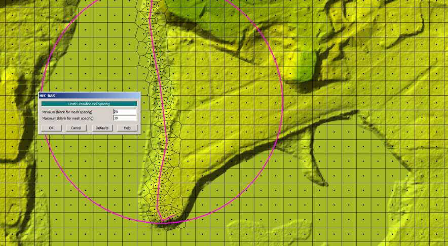
16 2D Flow Area Calculations High resolution Digital Terrain Map Lower resolution computational mesh 16
17 2D Flow Area Linkages 2D Flow Areas can be linked to 1D Flow Reaches 1D Flow Reaches Upstream Downstream Lateral Connections Storage Areas or other 2D Flow Areas External Boundary Condition Normal Depth, Rating Curve, Stage or Flow time series 17
18 18 Post-Processing - Depth
19 19 Post-Processing - Depth
20 20 Post-Processing Velocity
21 HEC-RAS 2D Riverine Applications Useful for riverine flow outside of well-defined, single channels: Inter-connected or braided channels Dam breach flood waves with unpredictable paths 21
22 22 HEC-RAS 2D Example Application Dam Breach
23 23 HEC-RAS 2D Example Application Dam Breach
24 24 HEC-RAS 2D Applications Dam Breach
25 25 HEC-RAS 2D Applications Dam Breach
26 HEC-RAS 2D Technical Advantages Implicit Finite Volume approach Improved stability Cells can start completely dry More robust than finite element or finite difference Allows for larger time steps than explicit methods Unstructured Mesh Flexibility Cells do not have flat bottom Allows larger computational cells without loss of terrain details Cells can be sized according to terrain features 26
27 HEC-RAS 2D Project Advantages Public Domain No license fees Large community of practitioners Widely accepted as HEC product Pre- and Post-processing in MAPPER (and GeoRAS) Can easily integrate 2D Flow Areas into existing HEC-RAS models Update old 1D HEC-RAS models No need to decide 1D or 2D when selecting modeling software Can use for screening approach and where to focus detail 27

28 CHALLENGES Mesh editing tools limited 28
29 CHALLENGES Some limited capacity for modeling structures Can represent weirs, levees, and culverts Cannot use full 1D bridge modeling capabilities 29
30 CHALLENGES Processing of map inundation, removing islands from high resolution grid; cleaning up Leaking Can use hydraulic connectivity plots 30
31 CHALLENGES Limited by quality of LiDAR/Raster Adding bathymetry to LiDAR for pure 2D Flow Area runs 31
32 32 Thank you.
Quality Assurance Reviews of Hydraulic Models Developed for the Central Valley Floodplain Evaluation and Delineation Program
 Quality Assurance Reviews of Hydraulic Models Developed for the Central Valley Floodplain Evaluation and Delineation Program Techniques Applied and Lessons Learned Seth Ahrens, P.E., CFM Selena Forman,
2D Modeling of Urban Flood Vulnerable Areas
 2D Modeling of Urban Flood Vulnerable Areas Sameer Dhalla, P.Eng. Dilnesaw Chekol, Ph.D. A.D. Latornell Conservation Symposium November 22, 2013 Outline 1. Toronto and Region 2. Evolution of Flood Management
Performing a Steady Flow Analysis
 C H A P T E R 7 Performing a Steady Flow Analysis This chapter discusses how to calculate steady flow water surface profiles. The chapter is divided into two parts. The first part discusses how to enter
Using GIS Data With HEC-RAS
 C H A P T E R 14 Using GIS Data With HEC-RAS HEC-RAS has the ability to import three-dimensional (3D) river schematic and cross section data created in a GIS or CADD system. While the HEC- RAS software
HEC-RAS. River Analysis System. Applications Guide. Version 4.1 January 2010. US Army Corps of Engineers Hydrologic Engineering Center CPD-70
 US Army Corps of Engineers Hydrologic Engineering Center HEC-RAS HEC-RAS River Analysis System Applications Guide Version 4.1 January 2010 Approved for Public Release. Distribution Unlimited CPD-70 REPORT
CHAPTER 9 CHANNELS APPENDIX A. Hydraulic Design Equations for Open Channel Flow
 CHAPTER 9 CHANNELS APPENDIX A Hydraulic Design Equations for Open Channel Flow SEPTEMBER 2009 CHAPTER 9 APPENDIX A Hydraulic Design Equations for Open Channel Flow Introduction The Equations presented
USING DETAILED 2D URBAN FLOODPLAIN MODELLING TO INFORM DEVELOPMENT PLANNING IN MISSISSAUGA, ON
 22nd Canadian Hydrotechnical Conference 22e Conférence canadienne d hydrotechnique Water for Sustainable Development : Coping with Climate and Environmental Changes L eau pour le développement durable:
Appendix 4-C. Open Channel Theory
 4-C-1 Appendix 4-C Open Channel Theory 4-C-2 Appendix 4.C - Table of Contents 4.C.1 Open Channel Flow Theory 4-C-3 4.C.2 Concepts 4-C-3 4.C.2.1 Specific Energy 4-C-3 4.C.2.2 Velocity Distribution Coefficient
What is the most obvious difference between pipe flow and open channel flow????????????? (in terms of flow conditions and energy situation)
") OPEN CHANNEL FLOW 1 3 Question What is the most obvious difference between pipe flow and open channel flow????????????? (in terms of flow conditions and energy situation) Typical open channel shapes Figure
OPEN CHANNEL FLOW 1 3 Question What is the most obvious difference between pipe flow and open channel flow????????????? (in terms of flow conditions and energy situation) Typical open channel shapes Figure
Environmental Data Management Programs
 Hydrologic Engineering Centre (HEC) Software CD Collection of programs, developed by the U.S. Army Corps of Engineers Environmental Data Management Programs Name: HEC-DSS Package Purpose: Data Storage
URBAN DRAINAGE CRITERIA
 URBAN DRAINAGE CRITERIA I. Introduction This division contains guidelines for drainage system design and establishes a policy for recognized and established engineering design of storm drain facilities
1 in 30 year 1 in 75 year 1 in 100 year 1 in 100 year plus climate change (+30%) 1 in 200 year
 1 in 200 year") Appendix C1 Surface Water Modelling 1 Overview 1.1 The Drain London modelling was designed to analyse the impact of heavy rainfall events across each London borough by assessing flow paths, velocities
Appendix C1 Surface Water Modelling 1 Overview 1.1 The Drain London modelling was designed to analyse the impact of heavy rainfall events across each London borough by assessing flow paths, velocities
USSD Workshop on Dam Break Analysis Applied to Tailings Dams
 USSD Workshop on Dam Break Analysis Applied to Tailings Dams Antecedents Newtonian / non-newtonian flows Available models that allow the simulation of non- Newtonian flows (tailings) Other models used
FLOODPLAIN DELINEATION IN MUGLA-DALAMAN PLAIN USING GIS BASED RIVER ANALYSIS SYSTEM
 FLOODPLAIN DELINEATION IN MUGLA-DALAMAN PLAIN USING GIS BASED RIVER ANALYSIS SYSTEM Dr. Murat Ali HATİPOĞLU Fatih KESKİN Kemal SEYREK State Hydraulics Works (DSI), Investigation and Planning Department
Simulating Sedimentation Model in Balarood Dam Reservoir Using CCHE2D Software
 Bulletin of Environment, Pharmacology and Life Sciences Bull. Env. Pharmacol. Life Sci., Vol 4 [1] December 2014: 67-72 2014 Academy for Environment and Life Sciences, India Online ISSN 2277-1808 Journal
National Dam Safety Program Technical Seminar #22. When is Flood Inundation Mapping Not Applicable for Forecasting
 National Dam Safety Program Technical Seminar #22 Thursday February 19 th 2015 Emmittsburg, MD When is Flood Inundation Mapping Not Applicable for Forecasting Victor Hom Hydrologic Services Division National
Fort Dodge Stormwater Master Planning. Prepared By: Ralph C. Stark, Jr., P.E., C.F.M. Joel N. Krause, P.E., C.F.M.
 Fort Dodge Stormwater Master Planning Prepared By: Ralph C. Stark, Jr., P.E., C.F.M. Joel N. Krause, P.E., C.F.M. Project Location Project Background Flooding History Localized flooding and storm sewer
ME6130 An introduction to CFD 1-1
 ME6130 An introduction to CFD 1-1 What is CFD? Computational fluid dynamics (CFD) is the science of predicting fluid flow, heat and mass transfer, chemical reactions, and related phenomena by solving numerically
Using HEC-RAS for Dam Break Studies
 Using HEC-RAS for Dam Break Studies August 2014 Approved for Public Release. Distribution Unlimited. TD-39 REPORT DOCUMENTATION PAGE Form Approved OMB No. 0704-0188 The public reporting burden for this
Use of OpenFoam in a CFD analysis of a finger type slug catcher. Dynaflow Conference 2011 January 13 2011, Rotterdam, the Netherlands
 Use of OpenFoam in a CFD analysis of a finger type slug catcher Dynaflow Conference 2011 January 13 2011, Rotterdam, the Netherlands Agenda Project background Analytical analysis of two-phase flow regimes
TENNESSEE GAS PIPELINE COMPANY, L.L.C.
 TENNESSEE GAS PIPELINE COMPANY, L.L.C. HYDROLOGIC & HYDRAULIC CALCULATIONS FOR WATERBODIES CROSSED BY CONNECTICUT PIPELINE EXPANSION PROJECT CONNECTICUT LOOP Submitted by: Tennessee Gas Pipeline Company,
 Using the Spatial Database Engine to develop a FEMA friendly Database and Asset Management Tool José Maria Guzmán, PE February 2009 GAFM 4th Annual Technical Conference Columbus, GA Outline Typical Datasets
COMPARING DSS-WISE- LITE TO OTHER DAM BREACH SOFTWARE
 National Dam Safety Program Technical Seminar No. 22 Dam Breach Modeling and Consequence Assessment National Emergency Training Center February 18-19, 2015 Emmitsburg, MD Brian Shane Cook, PE, LSIT formerly
MIKE 21 FLOW MODEL HINTS AND RECOMMENDATIONS IN APPLICATIONS WITH SIGNIFICANT FLOODING AND DRYING
 1 MIKE 21 FLOW MODEL HINTS AND RECOMMENDATIONS IN APPLICATIONS WITH SIGNIFICANT FLOODING AND DRYING This note is intended as a general guideline to setting up a standard MIKE 21 model for applications
SIMULATION OF SEDIMENT TRANSPORT AND CHANNEL MORPHOLOGY CHANGE IN LARGE RIVER SYSTEMS. Stephen H. Scott 1 and Yafei Jia 2
 US-CHINA WORKSHOP ON ADVANCED COMPUTATIONAL MODELLING IN HYDROSCIENCE & ENGINEERING September 19-21, Oxford, Mississippi, USA SIMULATION OF SEDIMENT TRANSPORT AND CHANNEL MORPHOLOGY CHANGE IN LARGE RIVER
HEC-RAS River Analysis System
 Table of Contents US Army Corps of Engineers Hydrologic Engineering Center HEC-RAS River Analysis System Hydraulic Reference Manual Version 4.1 January 010 Approved for Public Release. Distribution Unlimited
Employing Appropriate Software for Dam break Analysis and Flood Line rendering
 Employing Appropriate Software for Dam break Analysis and Flood Line rendering 1. Background The specialist field of Dam Safety has been developing in SA since about the 80 s. This has led to a well-developed
Floodplain Hydraulics! Hydrology and Floodplain Analysis Dr. Philip Bedient
 Floodplain Hydraulics! Hydrology and Floodplain Analysis Dr. Philip Bedient Open Channel Flow 1. Uniform flow - Manning s Eqn in a prismatic channel - Q, V, y, A, P, B, S and roughness are all constant
HYDROGRAPH ROUTING. E. Input data needed for channel routing include the inflow hydrograph and the channel characteristics
 HYDROGRAPH ROUTING. Introduction A. Two Types of Hydrograph Routing. Storage or Reservoir Routing. Channel Routing B. Reservoir Routing is used to determine the peak-flow attenuation that a hydrograph
Express Introductory Training in ANSYS Fluent Lecture 1 Introduction to the CFD Methodology
 Express Introductory Training in ANSYS Fluent Lecture 1 Introduction to the CFD Methodology Dimitrios Sofialidis Technical Manager, SimTec Ltd. Mechanical Engineer, PhD PRACE Autumn School 2013 - Industry
Appendix C - Risk Assessment: Technical Details. Appendix C - Risk Assessment: Technical Details
 Appendix C - Risk Assessment: Technical Details Page C1 C1 Surface Water Modelling 1. Introduction 1.1 BACKGROUND URS Scott Wilson has constructed 13 TUFLOW hydraulic models across the London Boroughs
A Method Using ArcMap to Create a Hydrologically conditioned Digital Elevation Model
 A Method Using ArcMap to Create a Hydrologically conditioned Digital Elevation Model High resolution topography derived from LiDAR data is becoming more readily available. This new data source of topography
DEVELOPING AN INUNDATION MAP STANDARD FOR THE U.S. ARMY CORPS OF ENGINEERS
 DEVELOPING AN INUNDATION MAP STANDARD FOR THE U.S. ARMY CORPS OF ENGINEERS Will Breitkreutz, Geographer, U.S. Army Corps of Engineers Kansas City District, Kansas City, Missouri, [email protected]
How To Develop A Flood Risk Map
 Recommended Procedures for Flood Velocity Data Development November 2012 Federal Emergency Management Agency Department of Homeland Security 500 C Street, SW Washington, DC 20472 This document was prepared
River Analysis System HEC-RAS
 Hydrologic Engineering Center River Analysis System HEC-RAS Release Notes Version 4.1 January 2010 Approved for Public Release Distribution Unlimited 1 Introduction Version 4.1 of the River Analysis System
Module 6 Case Studies
 Module 6 Case Studies 1 Lecture 6.1 A CFD Code for Turbomachinery Flows 2 Development of a CFD Code The lecture material in the previous Modules help the student to understand the domain knowledge required
Guide To Bridge Planning Tools
 Guide To Bridge Planning Tools The following bridge planning and hydrotechnical analysis tools (Excel spreadsheets, some with associated databases and VBA code), and GIS data-sets are available from the
How to Read a Flood Insurance Rate Map Tutorial. Developed September 2000 Updated June 2003
 How to Read a Flood Insurance Rate Map Tutorial Developed September 2000 Updated June 2003 Learning Objectives: The Objectives of the tutorial are: 1. To show the various types of flood maps, 2. To describe
Sample DEQ Plan Submitter s Checklist for Stormwater Management Plans
 APPENDIX IV Version: February 2, 2015 Sample DEQ Plan Submitter s Checklist for Stormwater Management Plans Please fill in all blanks and please reference the plan sheets/pages where the information may
Urban Flood Modelling
 Urban Flood Modelling Adrian J Saul Pennine Water Group Department of Civil and Structural Engineering University of Sheffield [email protected] 1 Need for Integrated Urban Drainage within an integrated
Evaluation of Open Channel Flow Equations. Introduction :
 Evaluation of Open Channel Flow Equations Introduction : Most common hydraulic equations for open channels relate the section averaged mean velocity (V) to hydraulic radius (R) and hydraulic gradient (S).
CLEARWATER DAM BLACK RIVER, MISSOURI MAJOR REHABILITATION STUDY
 US Army Corps of Engineers Little Rock District CLEARWATER DAM BLACK RIVER, MISSOURI MAJOR REHABILITATION STUDY HYDROLOGIC AND HYDRAULIC ANALYSES NOTES: 1) All elevations listed in this report are referenced
Open Channel Flow 2F-2. A. Introduction. B. Definitions. Design Manual Chapter 2 - Stormwater 2F - Open Channel Flow
 Design Manual Chapter 2 - Stormwater 2F - Open Channel Flow 2F-2 Open Channel Flow A. Introduction The beginning of any channel design or modification is to understand the hydraulics of the stream. The
Interactive comment on A simple 2-D inundation model for incorporating flood damage in urban drainage planning by A. Pathirana et al.
 Hydrol. Earth Syst. Sci. Discuss., 5, C2756 C2764, 2010 www.hydrol-earth-syst-sci-discuss.net/5/c2756/2010/ Author(s) 2010. This work is distributed under the Creative Commons Attribute 3.0 License. Hydrology
Experiment (13): Flow channel
: Flow channel") Introduction: An open channel is a duct in which the liquid flows with a free surface exposed to atmospheric pressure. Along the length of the duct, the pressure at the surface is therefore constant and
Introduction: An open channel is a duct in which the liquid flows with a free surface exposed to atmospheric pressure. Along the length of the duct, the pressure at the surface is therefore constant and
Effect of barrages on water level in estuaries
 Indian Journal of Geo-Marine Sciences Vol. 43 (7), July 2014, pp. 1364-1369 Effect of barrages on water level in estuaries S S Chavan *, M D Sawant, Prabhat Chandra & T Nagendra Central Water and Power
Designing a Basic White Water Canoe/Kayak Course using InfoWorks ICM
 Designing a Basic White Water Canoe/Kayak Course using InfoWorks ICM Adam Cambridge Hydrologist, Sinclair Knight Merz Robert Morden Senior Hydrologist, Sinclair Knight Merz Summary A functional design
SIMPLIFIED INUNDATION MAPS FOR EMERGENCY ACTION PLANS. National Dam Safety Review Board Emergency Action Plan Workgroup
 SIMPLIFIED INUNDATION MAPS FOR EMERGENCY ACTION PLANS National Dam Safety Review Board Emergency Action Plan Workgroup EXECUTIVE SUMMARY Development of Emergency Action Plans (EAPs) for all high and significant
Community RiskMAP Questionnaire
 Community RiskMAP Questionnaire Please provide the following information County Date: Community Name/Organization: Your Your E-mail: Contact Preference: E-mail Phone Mail The Federal Emergency Management
HYDROLOGIC/HYDRAULIC MODELING OF WESTMINSTER WATERSHED ORANGE COUNTY, CALIFORNIA
 HYDROLOGIC/HYDRAULIC MODELING OF WESTMINSTER WATERSHED ORANGE COUNTY, CALIFORNIA James Chieh, Ph.D., P.E., Senior Hydraulic Engineer, USACE, Los Angeles, California, [email protected]; Jay Pak,
Flood Risk Analysis considering 2 types of uncertainty
 US Army Corps of Engineers Institute for Water Resources Hydrologic Engineering Center Flood Risk Analysis considering 2 types of uncertainty Beth Faber, PhD, PE Hydrologic Engineering Center (HEC) US
THE UNIVERSITY OF TRINIDAD & TOBAGO
 THE UNIVERSITY OF TRINIDAD & TOBAGO FINAL ASSESSMENT/EXAMINATIONS APRIL 2014 Course Code and Title: Programme: Date and Time: Duration: HYDRAULICS FLUD2006 BASc. Civil Engineering Wednesday 16 th April,
STORMWATER MANAGEMENT CHECKLIST
 STORMWATER MANAGEMENT CHECKLIST *This checklist must be completed and part of the Land Disturbing Permit submittal for review if the acreage disturbed is one (1) acre or more: I. SUPPORTING DATA Narrative
21. Channel flow III (8.10 8.11)
") 21. Channel flow III (8.10 8.11) 1. Hydraulic jump 2. Non-uniform flow section types 3. Step calculation of water surface 4. Flow measuring in channels 5. Examples E22, E24, and E25 1. Hydraulic jump Occurs
21. Channel flow III (8.10 8.11) 1. Hydraulic jump 2. Non-uniform flow section types 3. Step calculation of water surface 4. Flow measuring in channels 5. Examples E22, E24, and E25 1. Hydraulic jump Occurs
Appendix F Benefit-Cost Analysis of Flood Protection Measures
 Appendix F Benefit-Cost Analysis of Flood Protection Measures Acronyms used in Appendix F: AA B AA C AA D BC BFE EAD FEMA NED O&M PV RED USACE Average Annual Benefits Average Annual Cost Average Annual
STATE OF COLORADO DEPARTMENT OF NATURAL RESOURCES DIVISION OF WATER RESOURCES GUIDELINES FOR DAM BREACH ANALYSIS
 STATE OF COLORADO DEPARTMENT OF NATURAL RESOURCES DIVISION OF WATER RESOURCES OFFICE OF THE STATE ENGINEER DAM SAFETY BRANCH GUIDELINES FOR DAM BREACH ANALYSIS February 10, 2010 Telephone (303) 866-3581
How To Run A Cdef Simulation
 Simple CFD Simulations and Visualisation using OpenFOAM and ParaView Sachiko Arvelius, PhD Purpose of this presentation To show my competence in CFD (Computational Fluid Dynamics) simulation and visualisation
The Alternatives of Flood Mitigation in The Downstream Area of Mun River Basin
 The Alternatives of Flood Mitigation in The Downstream Area of Mun River Basin Dr.Phattaporn Mekpruksawong 1, Thana Suwattana 2 and Narong Meepayoong 3 1 Senior Civil Engineer, Office of Project Management,
Topic 8: Open Channel Flow
 3.1 Course Number: CE 365K Course Title: Hydraulic Engineering Design Course Instructor: R.J. Charbeneau Subject: Open Channel Hydraulics Topics Covered: 8. Open Channel Flow and Manning Equation 9. Energy,
DANIELS RUN STREAM RESTORATION, FAIRFAX, VIRGINIA: FLOODPLAIN ANALYSIS REPORT
 DANIELS RUN STREAM RESTORATION, FAIRFAX, VIRGINIA: FLOODPLAIN ANALYSIS REPORT By: Conor C. Shea Stream Habitat Assessment and Restoration Program U.S. Fish and Wildlife Service CBFO-S07-01 Prepared in
UTILITIZATION OF ECOHYDROLOGIC MODELS IN FLOODPLAIN FISH PASSAGE AND HABITAT RESTORATION EVALUATION
 UTILITIZATION OF ECOHYDROLOGIC MODELS IN FLOODPLAIN FISH PASSAGE AND HABITAT RESTORATION EVALUATION Joshua A. Israel, Fish Biologist, U.S Bureau of Reclamation, Sacramento, CA. [email protected]; Paul
Flow Through an Abrupt Constriction. 2D Hydrodynamic Model Performance and Influence of Spatial Resolution
 Flow Through an Abrupt Constriction 2D Hydrodynamic Model Performance and Influence of Spatial Resolution Cathie Louise Barton BE (Civil) School of Environmental Engineering Faculty of Environmental Sciences
The AIR Inland Flood Model for the United States In Spring 2011, heavy rainfall and snowmelt produced massive flooding along the Mississippi River,
 The AIR Inland Flood Model for the United States In Spring 2011, heavy rainfall and snowmelt produced massive flooding along the Mississippi River, inundating huge swaths of land across seven states. As
DAM-BREAK SOLUTIONS FOR A PARTIAL BREACH
 DAM-BREAK SOLUTIONS FOR A PARTIAL BREACH A thesis submitted in partial fulfilment of the requirements for the Degree of Doctor of Philosophy in Civil Engineering at the University of Canterbury by Salahudin
OPTIMISE TANK DESIGN USING CFD. Lisa Brown. Parsons Brinckerhoff
 OPTIMISE TANK DESIGN USING CFD Paper Presented by: Lisa Brown Authors: Lisa Brown, General Manager, Franz Jacobsen, Senior Water Engineer, Parsons Brinckerhoff 72 nd Annual Water Industry Engineers and
COMPUTATIONAL FLOW MODEL OF WESTFALL'S 4000 OPEN CHANNEL MIXER 411527-1R1. By Kimbal A. Hall, PE. Submitted to: WESTFALL MANUFACTURING COMPANY
 COMPUTATIONAL FLOW MODEL OF WESTFALL'S 4000 OPEN CHANNEL MIXER 411527-1R1 By Kimbal A. Hall, PE Submitted to: WESTFALL MANUFACTURING COMPANY FEBRUARY 2012 ALDEN RESEARCH LABORATORY, INC. 30 Shrewsbury
National Weather Service Flash Flood Modeling and Warning Services
 National Weather Service Flash Flood Modeling and Warning Services Seann Reed, Middle Atlantic River Forecast Center Peter Ahnert, Middle Atlantic River Forecast Center August 23, 2012 USACE Flood Risk
Defra/Environment Agency Flood and Coastal Defence R&D Programme
 Defra/Environment Agency Flood and Coastal Defence R&D Programme Benchmarking Hydraulic River Modelling Software Packages Results L (Contraction & Expansion) R&D Technical Report: W5-105/TR2L TECHNICAL
ROLE OF THE MODELING, MAPPING, AND CONSEQUENCES PRODUCTION CENTER
 ROLE OF THE MODELING, MAPPING, AND CONSEQUENCES PRODUCTION CENTER Russ Wyckoff, P.E., CFM, MMC Modeling Lead, Tulsa District, USACE, Tulsa, Oklahoma, [email protected] ABSTRACT: The goal of
...Eq(11.6) The energy loss in the jump is dependent on the two depths y 1 and y 2 3 = E =...Eq(11.7)
 The energy loss in the jump is dependent on the two depths y 1 and y 2 3 = E =...Eq(11.7)") . Open Channel Flow Contd.5 Hydraulic Jump A hydraulic jump occurs when water in an open channel is flowing supercritical and is slowed by a deepening of the channel or obstruction in the channel. The
. Open Channel Flow Contd.5 Hydraulic Jump A hydraulic jump occurs when water in an open channel is flowing supercritical and is slowed by a deepening of the channel or obstruction in the channel. The
2.0 BASIC CONCEPTS OF OPEN CHANNEL FLOW MEASUREMENT
 2.0 BASIC CONCEPTS OF OPEN CHANNEL FLOW MEASUREMENT Open channel flow is defined as flow in any channel where the liquid flows with a free surface. Open channel flow is not under pressure; gravity is the
EFFECTS OF ARUNDO DONAX ON RIVER HYDRAULICS, SEDIMENT TRANSPORT, AND GEOMORPHOLOGY, SANTA MARGARITA RIVER, CALIFORNIA
 EFFECTS OF ARUNDO DONAX ON RIVER HYDRAULICS, SEDIMENT TRANSPORT, AND GEOMORPHOLOGY, SANTA MARGARITA RIVER, CALIFORNIA René Leclerc Geomorphologist Robert C. MacArthur, Ph.D., P.E. Principal Headwaters
Chapter 7 Ditches and Channels
 Chapter 7 Ditches and Channels TABLE OF CONTENTS CHAPTER 7 - DITCHES AND CHANNELS... 7-1 7.1 Introduction... 7-1 7.2 Design Policy... 7-2 7.2.1 Federal Policy... 7-2 7.2.2 Commonwealth of Virginia Policy...
Model of a flow in intersecting microchannels. Denis Semyonov
 Model of a flow in intersecting microchannels Denis Semyonov LUT 2012 Content Objectives Motivation Model implementation Simulation Results Conclusion Objectives A flow and a reaction model is required
Modelling Flood Inundation of Urban Areas in the UK Using 2D / 1D Hydraulic Models
 Modelling Flood Inundation of Urban Areas in the UK Using 2D / 1D Hydraulic Models W.J. Syme B.E., M.Eng.Sc. Associate, WBM Pty. Ltd., Australia M.G. Pinnell Bsc Msc MCIWEM Principal Hydrologist, Symonds
STATE OF FLORIDA DEPARTMENT OF TRANSPORTATION DRAINAGE HANDBOOK OPEN CHANNEL. OFFICE OF DESIGN, DRAINAGE SECTION November 2009 TALLAHASSEE, FLORIDA
 STATE OF FLORIDA DEPARTMENT OF TRANSPORTATION DRAINAGE HANDBOOK OPEN CHANNEL OFFICE OF DESIGN, DRAINAGE SECTION TALLAHASSEE, FLORIDA Table of Contents Open Channel Handbook Chapter 1 Introduction... 1
Lecture 22 Example Culvert Design Much of the following is based on the USBR technical publication Design of Small Canal Structures (1978)
") Lecture 22 Example Culvert Design Much of the following is based on the USBR technical publication Design of Small Canal Structures (1978) I. An Example Culvert Design Design a concrete culvert using the
Lecture 22 Example Culvert Design Much of the following is based on the USBR technical publication Design of Small Canal Structures (1978) I. An Example Culvert Design Design a concrete culvert using the
UNION COUNTY, FLORIDA AND INCORPORATED AREAS
 UNION COUNTY, FLORIDA AND INCORPORATED AREAS COMMUNITY NAME COMMUNITY NUMBER LAKE BUTLER, CITY OF 120595 RAIFORD, TOWN OF 120593 UNION COUNTY 120422 (UNINCORPORATED AREAS) WORTHINGTON SPRINGS, CITY OF
ROSE CREEK WATERSHED HYDROLOGIC, HYDRAULIC, SEDIMENT TRANSPORT, AND GEOMORPHIC ANALYSES TASK 1 EXISTING DATA AND INFORMATION SUMMARY REPORT BACKGROUND
 ROSE CREEK WATERSHED HYDROLOGIC, HYDRAULIC, SEDIMENT TRANSPORT, AND GEOMORPHIC ANALYSES TASK 1 EXISTING DATA AND INFORMATION SUMMARY REPORT BACKGROUND The Rose Creek Watershed (RCW) consists of three planning
Guidance for Flood Risk Analysis and Mapping. Changes Since Last FIRM
 Guidance for Flood Risk Analysis and Mapping Changes Since Last FIRM May 2014 This guidance document supports effective and efficient implementation of flood risk analysis and mapping standards codified
Geoprocessing Tools for Surface and Basement Flooding Analysis in SWMM
 3 Geoprocessing Tools for Surface and Basement Flooding Analysis in SWMM Eric White, James Knighton, Gary Martens, Matthew Plourde and Rajesh Rajan A geoprocessing routine was used for the development
TVM 4155 Numerical modelling and hydraulics 10. March 2014. OpenFOAM homework
 TVM 4155 Numerical modelling and hydraulics 10. March 2014 OpenFOAM homework OpenFOAM is the most popular open-source CFD program in the world today. In this homework we will use the program to determine
Overset Grids Technology in STAR-CCM+: Methodology and Applications
 Overset Grids Technology in STAR-CCM+: Methodology and Applications Eberhard Schreck, Milovan Perić and Deryl Snyder [email protected] [email protected] [email protected]
FLOOD PROTECTION BENEFITS
 IV. (340 points) Flood Protection Benefits A. Existing and potential urban development in the floodplain (50) 1. Describe the existing and potential urban development at the site and the nature of the
Public Draft. Attachment 8F: Flood Damage Analysis. 2012 Central Valley Flood Protection Plan. January 2012
 2012 Central Valley Flood Protection Plan Attachment 8F: Flood Damage Analysis January 2012 STATE OF CALIFORNIA THE NATURAL RESOURCES AGENCY DEPARTMENT OF WATER RESOURCES This page left blank intentionally.
Customer Training Material. Lecture 2. Introduction to. Methodology ANSYS FLUENT. ANSYS, Inc. Proprietary 2010 ANSYS, Inc. All rights reserved.
 Lecture 2 Introduction to CFD Methodology Introduction to ANSYS FLUENT L2-1 What is CFD? Computational Fluid Dynamics (CFD) is the science of predicting fluid flow, heat and mass transfer, chemical reactions,
TUFLOW Testing and Validation
 TUFLOW Testing and Validation Christopher. D. Huxley A thesis submitted in partial fulfilment Of the degree of Bachelor of Engineering in Environmental Engineering School of Environmental Engineering Griffith
Methods for Determination of Safe Yield and Compensation Water from Storage Reservoirs
 US Army Corps of Engineers Hydrologic Engineering Center Methods for Determination of Safe Yield and Compensation Water from Storage Reservoirs October 1966 Approved for Public Release. Distribution Unlimited.
EVALUATION OF UNSTEADY OPEN CHANNEL FLOW CHARACTERISTICS OVER A CRUMP WEIR
 EVALUATION OF UNSTEADY OPEN CHANNEL FLOW CHARACTERISTICS OVER A CRUMP WEIR Mohd Adib Mohd Razi, Dwi Tjahjanto, Wan Afnizan Wan Mohamed, Siti Norashikin Binti Husin Department of Water Resource and Environmental
Hydrologic Engineering Techniques for Regional Water Resources Planning
 US Army Corps of Engineers Hydrologic Engineering Center Hydrologic Engineering Techniques for Regional Water Resources Planning October 1969 Approved for Public Release. Distribution Unlimited. TP-17
Basic Hydrology. Time of Concentration Methodology
 Basic Hydrology Time of Concentration Methodology By: Paul Schiariti, P.E., CPESC Mercer County Soil Conservation District What is the Time of Concentration? The time it takes for runoff to travel from
Small Dam Hazard Assessment Inventory
 Small Dam Hazard Assessment Inventory What would happen if your dam were to fail? This is a question that most dam owners hope they will never have to answer. However it is a question you, as a responsible
ECONOMIC ANALYSIS FLOOD DAMAGE REDUCTION. Lower Carmel River Floodplain Restoration and Enhancement Project
 ECONOMIC ANALYSIS FLOOD DAMAGE REDUCTION Lower Carmel River Floodplain Restoration and Enhancement Project I. Description of the Project and its Relationship to Other Projects in the Proposal The Lower
STORM DRAINS CHAPTER 7
 CHAPTER 7 Chapter 7 - Storm Drains A storm drain is a drainage system that conveys water or stormwater, consisting of two or more pipes in a series connected by one or more structures. Storm drains collect
06 - NATIONAL PLUVIAL FLOOD MAPPING FOR ALL IRELAND THE MODELLING APPROACH
 06 - NATIONAL PLUVIAL FLOOD MAPPING FOR ALL IRELAND THE MODELLING APPROACH Richard Kellagher 1, Mike Panzeri 1, Julien L Homme 1, Yannick Cesses 1, Ben Gouldby 1 John Martin 2, Oliver Nicholson 2, Mark