DANIELS RUN STREAM RESTORATION, FAIRFAX, VIRGINIA: FLOODPLAIN ANALYSIS REPORT
|
|
|
- Lora Cameron
- 8 years ago
- Views:
Transcription
1 DANIELS RUN STREAM RESTORATION, FAIRFAX, VIRGINIA: FLOODPLAIN ANALYSIS REPORT By: Conor C. Shea Stream Habitat Assessment and Restoration Program U.S. Fish and Wildlife Service CBFO-S07-01 Prepared in cooperation with: Army-Navy Country Club, Fairfax, Virginia Annapolis, MD March 2007

2 TABLE OF CONTENTS I. PURPOSE...1 II. PREVIOUS STUDIES...1 III. HYDROLOGY...1 IV. HDYRAULIC ANALYSIS...3 A. Model Development...3 B. Model Results...3 V. CONCLUSIONS...4 REFERENCE APPENDIX A: WATER SURFACE PROFILES Page ii of ii

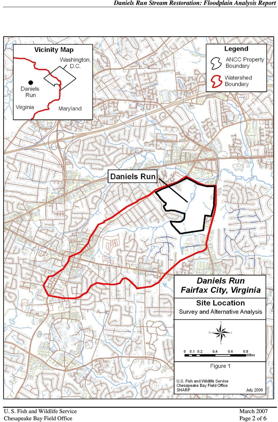
3 I. PURPOSE The Army Navy Country Club, Inc. (ANCC) and the U.S. Fish and Wildlife Service (Service) have partnered to restore Daniels Run. The goal of stream restoration is to return the main stem of Daniels Run to a stable, self-maintaining state while meeting the aesthetic goals of the ANCC. Successful stream restoration will also address some water quality issues including reducing sediment and nutrients, which are significant issues for the Chesapeake Bay and its natural resources. Daniels Run is a perennial stream that is a tributary to Accotink Creek. The stream runs through the ANCC in the City of Fairfax, Fairfax, County, VA (Figure 1). Daniels Run originates in the central portion of the City of Fairfax and flows in a general northeastern direction. Daniels Run enters the ANCC property along the southwestern perimeter of the site, continues on-site for approximately 2,800 feet, where it discharges into Accotink Creek at the northern perimeter of the site. The limits of the stream restoration project are totally contained within the golf course property. The purpose of this report is to document the floodplain analysis prepared to investigate impacts of the stream restoration on flood elevations. The Service used HEC-RAS to model hydraulic conditions for major floods under existing conditions and for proposed conditions after stream restoration. The analysis shows the changes in water surface elevations between existing and proposed conditions. II. PREVIOUS STUDIES The Federal Emergency Management Agency (FEMA) prepared a Flood Insurance Study (FIS) for the City of Fairfax in The FIS has been updated since 1971 several times. A substantial updating of the FIS was completed in February 2003 and the FIS was last revised in 2006 (FEMA, 2006). Daniels Run was one of the tributaries to Accotink Creek examined using detailed methods. III. HYDROLOGY FEMA analyses floods for the 10-year, 50-year, 100-year, and 500-year return period floods. In the February 2003 revision of the FIS, FEMA estimated discharges for the four return periods using HEC- HMS, a computer model developed by the U.S. Army Corps of Engineers. HEC-HMS computes runoff on the basis of rainfall, landuse, and hydraulic properties of the watershed. FEMA estimates discharge for three locations along Daniels Run: at Accotink Creek, upstream of the confluence with Little River Hills Tributary, and at Little River Turnpike. The FEMA discharges are listed in Table 1. Because the restoration reach is located below the confluence of Little River Hills Tributary, the Service used the FEMA discharges for Daniels Run at Accotink Creek to prepare this study. This is also consistent with FEMA s analysis of this portion of Daniels Run. Table 1: FEMA Peak Discharges for Daniels Run (cubic feet per second) Location Return Period 10-Year 50-Year 100-Year 500-Year At confluence with Accotink Creek 1,850 2,820 3,220 4,460 Upstream of the confluence with Little River Hills Tributary 870 1,400 1,560 2,020 At Little River Turnpike Page 1 of 6
.")
4 Page 2 of 6
5 IV. HDYRAULIC ANALYSIS The Service used HEC-RAS to prepare a hydraulic analysis of the portion of Daniels Run flowing through the ANCC. HEC-RAS is a computer program developed by the U.S. Army Corps of Engineers to compute water surface profiles. FEMA also employed HEC-RAS to prepare the FIS. Because FEMA s modeling was coarse (i.e. the cross sections are widely spaced), the Service developed it own model using detailed topographic mapping to better represent the changes created by the stream restoration. A. Model Development The model was developed as follows: Base Mapping: The Service prepared a detailed topographic survey of the existing channel. The survey was combined with surveys prepared by others of the golf course for the ANCC to produce an accurate map of existing conditions. Detailed grading plans for the proposed stream restoration was merged with the existing conditions base mapping to create a base map for proposed conditions. Stream Centerline: The stream centerline for both existing and proposed conditions was located on the base maps. Because the stream restoration will remove a series of tortuous meander bends in the stream, the length of the proposed stream is shorter than the existing stream reach. Model Extents: The models extend from the start of Daniels Run at Accotink Creek upstream to where Daniels Run enters the ANCC property. This point is about 126 feet above the upstream limit of the stream restoration project. Stream Cross Sections: Stream cross sections were located across the 500-year floodplain using a CAD package. The cross sections were located about one to two bankfull widths apart. Initially, cross sections were located farther apart, but initial model results indicated the need for closer spacing to lower the change in conveyance between adjacent sections to recommended limits. HEC-RAS Geometry Dataset: The Service imported the CAD data into HEC-RAS using GIS format. Cross sections were filtered and edited to remove any inconsistencies. Reach lengths were checked and adjusted as necessary. The Service assigned Manning s n values of for the channel and for the floodplain. Manning s n values were based on field analysis and professional experience. Starting Water Surface Elevations: The starting water surface elevations were taken from the FEMA study (FEMA 2006). Water surface elevations in the lower portions of Daniels Run (the first feet) are subject to backwater from Accotink Creek for the four return periods. Water surface profiles are flat until the ground rises sufficiently to raise the stream above the backwater. Flow Regime: There are several areas of sudden changes in cross section area or steep channel that create hydraulic jumps for high flow events. Daniels Run was run as a mixed-model (subcritical and supercritical flow) to better simulate flow conditions. B. Model Results The water surface profiles for Existing and Proposed Conditions for the four return periods are compared in Figures A-1 to A-4 in Appendix A. Changes in water surface elevations are minor: Page 3 of 6

6 Generally, water surface elevations are similar under Existing and Proposed conditions because the stream restoration is modifying the bankfull channel. Under the FEMA discharges (i.e., major floods), the topography of the floodplain controls water surface elevations along Daniels Run. The stream restoration plans do not call for large scale changes in the floodplain, so water surface elevations are similar. Water surface elevations for the 100-year and 500-year return period are lower at the upstream end of the project area. There are small increases of less than 0.2 feet for the 10-year and 50-year return period. There is one location (i.e., station 8+00) on the longitudinal profile (Appendix A) where the water surface elevation increases more than one foot for the 100-year return period. There is a scour hole at this location and this section of stream channel is entrenched under existing conditions. However, under proposed conditions, a series of step-pools will replace the scour hole and the channel elevation will be raise to restore the stream to its historic floodplain. The water surface increase occurs over a limited distance and the water surface elevation decreases under proposed conditions upstream of the scour hole. V. CONCLUSIONS The restoration of Daniels Run will create only minor changes in water surface elevation for major floods (i.e. FEMA 10-year, 50-year, 100-year, and 500-year discharges). Changes for the 100-year discharge are local in nature and do not extend off-site. Page 4 of 6
 on the longitudinal profile (Appendix A) where the water surface elevation increases more than one foot for the 100-year return period.")
7 REFERENCES FEMA (2006). Flood Insurance Study, City of Fairfax, Independent City, Flood Insurance Study Number V000B, Revised June 2, 2006.

8 APPENDIX A: WATER SURFACE PROFILES

9 Page A1 of A4

10 Page A2 of A4

11 Page A3 of A4

12 Page A4 of A4

CITY UTILITIES DESIGN STANDARDS MANUAL
 CITY UTILITIES DESIGN STANDARDS MANUAL Book 2 (SW) SW9 June 2015 SW9.01 Purpose This Chapter provides information for the design of open channels for the conveyance of stormwater in the City of Fort Wayne.
ROSE CREEK WATERSHED HYDROLOGIC, HYDRAULIC, SEDIMENT TRANSPORT, AND GEOMORPHIC ANALYSES TASK 1 EXISTING DATA AND INFORMATION SUMMARY REPORT BACKGROUND
 ROSE CREEK WATERSHED HYDROLOGIC, HYDRAULIC, SEDIMENT TRANSPORT, AND GEOMORPHIC ANALYSES TASK 1 EXISTING DATA AND INFORMATION SUMMARY REPORT BACKGROUND The Rose Creek Watershed (RCW) consists of three planning
HUDSON RIVER-BLACK RIVER REGULATING DISTRICT BOARD MEETING JUNE 10, 2014
 HUDSON RIVER-BLACK RIVER REGULATING DISTRICT BOARD MEETING JUNE 10, 2014 PRESENTATION TOPICS Analysis Objectives Analysis Dam Removal Plan Dam Remediation Plan Effects Analysis Permit Requirements Decision
CHAPTER 9 CHANNELS APPENDIX A. Hydraulic Design Equations for Open Channel Flow
 CHAPTER 9 CHANNELS APPENDIX A Hydraulic Design Equations for Open Channel Flow SEPTEMBER 2009 CHAPTER 9 APPENDIX A Hydraulic Design Equations for Open Channel Flow Introduction The Equations presented
Environmental Data Management Programs
 Hydrologic Engineering Centre (HEC) Software CD Collection of programs, developed by the U.S. Army Corps of Engineers Environmental Data Management Programs Name: HEC-DSS Package Purpose: Data Storage
Prattsville Berm Removal Project. 1.0 Project Location
 Prattsville Berm Removal Project 1.0 Project Location The project site is located between the New York State Route 23 Bridge over the Schoharie Creek and the Schoharie Reservoir. The restoration plan encompassed
Quality Assurance Reviews of Hydraulic Models Developed for the Central Valley Floodplain Evaluation and Delineation Program
 Quality Assurance Reviews of Hydraulic Models Developed for the Central Valley Floodplain Evaluation and Delineation Program Techniques Applied and Lessons Learned Seth Ahrens, P.E., CFM Selena Forman,
HYDROLOGIC/HYDRAULIC MODELING OF WESTMINSTER WATERSHED ORANGE COUNTY, CALIFORNIA
 HYDROLOGIC/HYDRAULIC MODELING OF WESTMINSTER WATERSHED ORANGE COUNTY, CALIFORNIA James Chieh, Ph.D., P.E., Senior Hydraulic Engineer, USACE, Los Angeles, California, Shih.H.Chieh@usace.army.mil; Jay Pak,
URBAN DRAINAGE CRITERIA
 URBAN DRAINAGE CRITERIA I. Introduction This division contains guidelines for drainage system design and establishes a policy for recognized and established engineering design of storm drain facilities
GLOSSARY OF TERMS CHAPTER 11 WORD DEFINITION SOURCE. Leopold
 CHAPTER 11 GLOSSARY OF TERMS Active Channel The channel that contains the discharge Leopold where channel maintenance is most effective, sediment are actively transported and deposited, and that are capable
A Flood Warning System for City of Findlay, Ohio
 A Flood Warning System for City of Findlay, Ohio Matt Whitehead US Geological Survey, Ohio Water Science Center 6480 Doubletree Avenue Columbus, Ohio 43229 Abstract The U.S. Geological Survey (USGS) and
5.14 Floodplains and Drainage/Hydrology
 I-70 East Final EIS 5.14 Floodplains and Drainage/Hydrology 5.14 Floodplains and Drainage/Hydrology This section discusses floodplain and drainage/hydrology resources and explains why they are important
FLOODPLAIN DELINEATION IN MUGLA-DALAMAN PLAIN USING GIS BASED RIVER ANALYSIS SYSTEM
 FLOODPLAIN DELINEATION IN MUGLA-DALAMAN PLAIN USING GIS BASED RIVER ANALYSIS SYSTEM Dr. Murat Ali HATİPOĞLU Fatih KESKİN Kemal SEYREK State Hydraulics Works (DSI), Investigation and Planning Department
FLOOD PROTECTION BENEFITS
 IV. (340 points) Flood Protection Benefits A. Existing and potential urban development in the floodplain (50) 1. Describe the existing and potential urban development at the site and the nature of the
The Teton Creek Restoration Project Summary:
 The Teton Creek Restoration Project Summary: The Teton Creek Restoration Project area extends for approximately one mile upstream from the Cemetery Road Bridge and includes the Aspen Pointe, The Aspens
The Alternatives of Flood Mitigation in The Downstream Area of Mun River Basin
 The Alternatives of Flood Mitigation in The Downstream Area of Mun River Basin Dr.Phattaporn Mekpruksawong 1, Thana Suwattana 2 and Narong Meepayoong 3 1 Senior Civil Engineer, Office of Project Management,
Appendix 4-C. Open Channel Theory
 4-C-1 Appendix 4-C Open Channel Theory 4-C-2 Appendix 4.C - Table of Contents 4.C.1 Open Channel Flow Theory 4-C-3 4.C.2 Concepts 4-C-3 4.C.2.1 Specific Energy 4-C-3 4.C.2.2 Velocity Distribution Coefficient
Procedures for No-Rise Certification For Proposed Developments in the Regulatory Floodway
 US Department of Homeland Security Region X 130 228 th Street, SW Bothell, WA 98021 Procedures for No-Rise Certification For Proposed Developments in the Regulatory Floodway Section 60.3 (d) (3) of the
ECONOMIC ANALYSIS FLOOD DAMAGE REDUCTION. Lower Carmel River Floodplain Restoration and Enhancement Project
 ECONOMIC ANALYSIS FLOOD DAMAGE REDUCTION Lower Carmel River Floodplain Restoration and Enhancement Project I. Description of the Project and its Relationship to Other Projects in the Proposal The Lower
Section 5 Floodplain Management Tools
 5.1 Floodprone Areas One of the major elements of the Master Plan is the updated 100-year floodplain and floodway boundary maps. This information provided the most up-to-date tools to protect homes and
HEC-RAS. River Analysis System. Applications Guide. Version 4.1 January 2010. US Army Corps of Engineers Hydrologic Engineering Center CPD-70
 US Army Corps of Engineers Hydrologic Engineering Center HEC-RAS HEC-RAS River Analysis System Applications Guide Version 4.1 January 2010 Approved for Public Release. Distribution Unlimited CPD-70 REPORT
UNION COUNTY, FLORIDA AND INCORPORATED AREAS
 UNION COUNTY, FLORIDA AND INCORPORATED AREAS COMMUNITY NAME COMMUNITY NUMBER LAKE BUTLER, CITY OF 120595 RAIFORD, TOWN OF 120593 UNION COUNTY 120422 (UNINCORPORATED AREAS) WORTHINGTON SPRINGS, CITY OF
USING DETAILED 2D URBAN FLOODPLAIN MODELLING TO INFORM DEVELOPMENT PLANNING IN MISSISSAUGA, ON
 22nd Canadian Hydrotechnical Conference 22e Conférence canadienne d hydrotechnique Water for Sustainable Development : Coping with Climate and Environmental Changes L eau pour le développement durable:
Evaluation of Open Channel Flow Equations. Introduction :
 Evaluation of Open Channel Flow Equations Introduction : Most common hydraulic equations for open channels relate the section averaged mean velocity (V) to hydraulic radius (R) and hydraulic gradient (S).
Topic 8: Open Channel Flow
 3.1 Course Number: CE 365K Course Title: Hydraulic Engineering Design Course Instructor: R.J. Charbeneau Subject: Open Channel Hydraulics Topics Covered: 8. Open Channel Flow and Manning Equation 9. Energy,
Catchment Scale Processes and River Restoration. Dr Jenny Mant Jenny@therrc.co.uk. The River Restoration Centre therrc.co.uk
 Catchment Scale Processes and River Restoration Dr Jenny Mant Jenny@therrc.co.uk The River Restoration Centre therrc.co.uk 3 Main Catchment Elements Hydrology Energy associated with the flow of water affects
SIMULATION OF SEDIMENT TRANSPORT AND CHANNEL MORPHOLOGY CHANGE IN LARGE RIVER SYSTEMS. Stephen H. Scott 1 and Yafei Jia 2
 US-CHINA WORKSHOP ON ADVANCED COMPUTATIONAL MODELLING IN HYDROSCIENCE & ENGINEERING September 19-21, Oxford, Mississippi, USA SIMULATION OF SEDIMENT TRANSPORT AND CHANNEL MORPHOLOGY CHANGE IN LARGE RIVER
Shooks Run Drainage Study Basic Terminology
 Shooks Run Drainage Study Basic Terminology PREPARED FOR: PREPARED BY: City of Colorado Springs CH2M DATE: April 9, 2015 Introduction This document is intended to provide an introduction to Colorado Springs
3.4 DRAINAGE PLAN. 3.4.1 Characteristics of Existing Drainages. 3.4.2 Master Drainage System. Section 3: Development Plan BUTTERFIELD SPECIFIC PLAN
 3.4 DRAINAGE PLAN This section describes the existing onsite drainage characteristics and improvements proposed within this Specific Plan. Following this description, drainage plan development standards
Mission Creek Flood Control & Restoration Project. City of Fremont, Alameda County
 Mission Creek Flood Control & Restoration Project City of Fremont, Alameda County Agenda Background Why are proposed improvements necessary? Proposed project components Challenges Construction schedule/phasing
Watershed Delineation
 ooooo Appendix D: Watershed Delineation Department of Environmental Protection Stream Survey Manual 113 Appendix D: Watershed Delineation Imagine a watershed as an enormous bowl. As water falls onto the
Hydrologic Engineering Techniques for Regional Water Resources Planning
 US Army Corps of Engineers Hydrologic Engineering Center Hydrologic Engineering Techniques for Regional Water Resources Planning October 1969 Approved for Public Release. Distribution Unlimited. TP-17
Performing a Steady Flow Analysis
 C H A P T E R 7 Performing a Steady Flow Analysis This chapter discusses how to calculate steady flow water surface profiles. The chapter is divided into two parts. The first part discusses how to enter
Methods for Determination of Safe Yield and Compensation Water from Storage Reservoirs
 US Army Corps of Engineers Hydrologic Engineering Center Methods for Determination of Safe Yield and Compensation Water from Storage Reservoirs October 1966 Approved for Public Release. Distribution Unlimited.
City of West Linn Public Works Design Standards 2010. Table of Contents
 City of West Linn Public Works Design Standards Table of Contents SECTION TWO STORM DRAIN REQUIREMENTS... 1 2.0000 STORM DRAINS... 1 2.0010 General Design Requirements...1 2.0011 Site Drainage Plans...2
Prepared by. Drew Davidge
 Flood Damage Estimation in the Upper Thames River Watershed CFCAS project: Assessment of Water Resources Risk and Vulnerability to Changing Climatic Conditions Project Report VII. August 2005 Prepared
Chapter 7 Ditches and Channels
 Chapter 7 Ditches and Channels TABLE OF CONTENTS CHAPTER 7 - DITCHES AND CHANNELS... 7-1 7.1 Introduction... 7-1 7.2 Design Policy... 7-2 7.2.1 Federal Policy... 7-2 7.2.2 Commonwealth of Virginia Policy...
2.0 BASIC CONCEPTS OF OPEN CHANNEL FLOW MEASUREMENT
 2.0 BASIC CONCEPTS OF OPEN CHANNEL FLOW MEASUREMENT Open channel flow is defined as flow in any channel where the liquid flows with a free surface. Open channel flow is not under pressure; gravity is the
STATE OF FLORIDA DEPARTMENT OF TRANSPORTATION DRAINAGE HANDBOOK OPEN CHANNEL. OFFICE OF DESIGN, DRAINAGE SECTION November 2009 TALLAHASSEE, FLORIDA
 STATE OF FLORIDA DEPARTMENT OF TRANSPORTATION DRAINAGE HANDBOOK OPEN CHANNEL OFFICE OF DESIGN, DRAINAGE SECTION TALLAHASSEE, FLORIDA Table of Contents Open Channel Handbook Chapter 1 Introduction... 1
TENNESSEE GAS PIPELINE COMPANY, L.L.C.
 TENNESSEE GAS PIPELINE COMPANY, L.L.C. HYDROLOGIC & HYDRAULIC CALCULATIONS FOR WATERBODIES CROSSED BY CONNECTICUT PIPELINE EXPANSION PROJECT CONNECTICUT LOOP Submitted by: Tennessee Gas Pipeline Company,
Drainage Design and Stormwater Pollution Prevention Manual
 , Texas Drainage Design and Stormwater Pollution Prevention Manual 2001 Teague Nall and Perkins, Inc. Engineers Consultants Fort Worth Irving Denton CITY OF DESOTO DRAINAGE DESIGN AND STORM WATER POLLUTION
Prepared By: Tom Parker Geum Environmental Consulting, Inc.
 Prepared By: Tom Parker Geum Environmental Consulting, Inc. Topics covered: Definition of riparian and floodplain restoration Floodplain attributes as a basis for developing criteria for restoration designs
How to Read a Flood Insurance Rate Map Tutorial. Developed September 2000 Updated June 2003
 How to Read a Flood Insurance Rate Map Tutorial Developed September 2000 Updated June 2003 Learning Objectives: The Objectives of the tutorial are: 1. To show the various types of flood maps, 2. To describe
7.0 Stream Restoration
 7.0 Stream Restoration 7.1 Issue Statements One of the primary concerns of residents in the Bassett Creek watershed is the maintenance of the natural beauty of the creek in residential and recreational
Using GIS Data With HEC-RAS
 C H A P T E R 14 Using GIS Data With HEC-RAS HEC-RAS has the ability to import three-dimensional (3D) river schematic and cross section data created in a GIS or CADD system. While the HEC- RAS software
The answers to some of the following questions are separated into two major categories:
 Following the recent flooding events for Front Range communities in Colorado, property owners, communities, and the National Flood Insurance Program are being presented with some new challenges in the
Assessing Rivers for Restoration Purposes. Ann L. Riley Waterways Restoration Institute
 Assessing Rivers for Restoration Purposes Ann L. Riley Waterways Restoration Institute Assessing Rivers for Restoration Purposes Ann L. Riley Waterways Restoration Institute Assessing Rivers for Restoration
Floodplain Connectivity in Restoration Design
 Floodplain Connectivity in Restoration Design 2015 Symposium on Restoration in a Contaminated Environment: Lessons Learned and Challenges in Moving Forward Part II April 2015 Karin Boyd Applied Geomorphology,
Plumas Watershed Forum. Review of Ongoing Projects. Updated 10/1/008
 Plumas Watershed Forum Review of Ongoing Projects Updated 10/1/008 Hosselkus II Restoration Project Approved Funding: $80,000 (A funds) Expended By 10/1/08: $79,603 This pond-and-plug creek restoration
Henry Van Offelen Natural Resource Scientist MN Center for Environmental Advocacy hvanoffelen@mncenter.org
 Henry Van Offelen Natural Resource Scientist MN Center for Environmental Advocacy hvanoffelen@mncenter.org Wetland study slide Water Quality NRE goals in watershed plans Protect habitat that remains.
A HYDROLOGIC NETWORK SUPPORTING SPATIALLY REFERENCED REGRESSION MODELING IN THE CHESAPEAKE BAY WATERSHED
 A HYDROLOGIC NETWORK SUPPORTING SPATIALLY REFERENCED REGRESSION MODELING IN THE CHESAPEAKE BAY WATERSHED JOHN W. BRAKEBILL 1* AND STEPHEN D. PRESTON 2 1 U.S. Geological Survey, Baltimore, MD, USA; 2 U.S.
General Permit for Activities Promoting Waterway - Floodplain Connectivity [working title]
![General Permit for Activities Promoting Waterway - Floodplain Connectivity [working title]](/thumbs/39/18645965.jpg "General Permit for Activities Promoting Waterway - Floodplain Connectivity [working title]") General Permit for Activities Promoting Waterway - Floodplain Connectivity [working title] Purpose These rules set forth the conditions under which a person may, without an individual removal-fill permit
General Permit for Activities Promoting Waterway - Floodplain Connectivity [working title] Purpose These rules set forth the conditions under which a person may, without an individual removal-fill permit
What We Do: Wetlands, Wildlife Habitat & Flood Hazards in the Root River Watershed
 What We Do: Wetlands, Wildlife Habitat & Flood Hazards in the Root River Watershed presented by Ceil Strauss, State Floodplain Manager DNR Ecological & Water Resources 1 EWR Roles In Floodplains Regulatory:
Harris County Flood Control District. Policy, Criteria, and Procedure Manual
 Harris County Flood Control District Policy, Criteria, and Procedure Manual For Approval and Acceptance of Infrastructure General Review October 10, 2003 Draft Please Provide Written Comments to the HCFCD
COLORADO FRONT RANGE FLOOD OF 2013:
 USDA NATURAL RESOURCES CONSERVATION SERVICE COLORADO COLORADO FRONT RANGE FLOOD OF 2013: Peak Flow Estimates at Selected Mountain Stream Locations December 2013 James Creek in Jamestown North Fork of the
2. BENEFIT:COST ECONOMIC ANALYSIS
 2. BENEFIT:COST ECONOMIC ANALYSIS 2.1 Riverine and Coastal A-Zone Flood Model Overview The Riverine and Coastal A-Zone Flood model (RCAZF) (Version 1.0, January 1995), a spreadsheetbased model developed
Index. protection. excavated drop inlet protection (Temporary) 6.50.1 6.51.1. Block and gravel inlet Protection (Temporary) 6.52.1
 6.50.1 6.51.1. Block and gravel inlet Protection (Temporary) 6.52.1") 6 Index inlet protection excavated drop inlet protection (Temporary) 6.50.1 HARDWARE CLOTH AND GRAVEL INLET PROTECTION Block and gravel inlet Protection (Temporary) sod drop inlet protection ROCK DOUGHNUT
6 Index inlet protection excavated drop inlet protection (Temporary) 6.50.1 HARDWARE CLOTH AND GRAVEL INLET PROTECTION Block and gravel inlet Protection (Temporary) sod drop inlet protection ROCK DOUGHNUT
Earth Science. River Systems and Landforms GEOGRAPHY 1710. The Hydrologic Cycle. Introduction. Running Water. Chapter 14.
 Earth Science GEOGRAPHY 1710 River Systems and Landforms DAVID R. SALLEE Robert W. Christopherson Charlie Thomsen Chapter 14 Introduction Rivers and streams are dynamic systems that continually adjust
ROSEAU COUNTY, MINNESOTA
 Roseau County ROSEAU COUNTY, MINNESOTA AND INCORPORATED AREAS Community Name Community Number BADGER, CITY OF 270412 GREENBUSH, CITY OF 270413 *ROOSEVELT, CITY OF 270781 ROSEAU, CITY OF 270414 ROSEAU COUNTY
Riprap-lined Swale (RS)
") Riprap-lined Swale (RS) Practice Description A riprap-lined swale is a natural or constructed channel with an erosion-resistant rock lining designed to carry concentrated runoff to a stable outlet. This
Riprap-lined Swale (RS) Practice Description A riprap-lined swale is a natural or constructed channel with an erosion-resistant rock lining designed to carry concentrated runoff to a stable outlet. This
Tookany Creek Flood Damage Reduction Feasibility Study Section 205 Continuing Authorities Program
 Tookany Creek Flood Damage Reduction Feasibility Study Section 205 Continuing Authorities Program Field Inspection Notes 27 29 September 2012 Introduction The U.S. Army Corps of Engineers (Corps), in
AZ EGER-PATAK HIDROLÓGIAI VIZSGÁLATA, A FELSZÍNI VÍZKÉSZLETEK VÁRHATÓ VÁLTOZÁSÁBÓL ADÓDÓ MÓDOSULÁSOK AZ ÉGHAJLATVÁLTOZÁS HATÁSÁRA
 AZ EGER-PATAK HIDROLÓGIAI VIZSGÁLATA, A FELSZÍNI VÍZKÉSZLETEK VÁRHATÓ VÁLTOZÁSÁBÓL ADÓDÓ MÓDOSULÁSOK AZ ÉGHAJLATVÁLTOZÁS HATÁSÁRA GÁBOR KEVE 1, GÉZA HAJNAL 2, KATALIN BENE 3, PÉTER TORMA 4 EXTRAPOLATING
3. Design Procedures. Design Procedures. Introduction
 Design Procedures 3. Design Procedures Introduction This chapter presents a procedure for the design of natural channels. The chapter primarily focuses on those physical properties of the channel required
Appendix H Dredging and Stream Channel Restoration
 Appendix H Dredging and Stream Channel Restoration Mankind s intrusion into the natural environment in West Virginia began in earnest following the Civil War when extractive industries and settlement all
CHAPTER 3 STORM DRAINAGE SYSTEMS
 CHAPTER 3 STORM DRAINAGE SYSTEMS 3.7 Storm Drains 3.7.1 Introduction After the tentative locations of inlets, drain pipes, and outfalls with tail-waters have been determined and the inlets sized, the next
Urban Stream Restoration Defining the Full Benefits of a Project. Warren C. High MACTEC Engineering and Consulting
 Urban Stream Restoration Defining the Full Benefits of a Project Warren C. High MACTEC Engineering and Consulting Economics in the Decision Process Return on Investment Willingness to Pay Municipal Growth
CDM. City of Jacksonville Master Stormwater Management Plan (MSMP) Update. December 2008 Update. Agenda. 1. Data Collection. 2.
 Update. December 2008 Update. Agenda. 1. Data Collection. 2.") City of Jacksonville Master Stormwater Management Plan (MSMP) Update December 2008 Update CDM Agenda 1. Data Collection 1. GIS/LiDAR 2. Survey 2. Water Quantity 1. SWMM Modeling 2. FEMA 3. Water Quality
City of Jacksonville Master Stormwater Management Plan (MSMP) Update December 2008 Update CDM Agenda 1. Data Collection 1. GIS/LiDAR 2. Survey 2. Water Quantity 1. SWMM Modeling 2. FEMA 3. Water Quality
Land Disturbance, Erosion Control and Stormwater Management Checklist. Walworth County Land Conservation Department
 Land Disturbance, Erosion Control and Stormwater Management Checklist Walworth County Land Conservation Department The following checklist is designed to assist the applicant in complying with the Walworth
Innovative Approaches in Flood Damage Reduction
 Innovative Approaches in Flood Damage Reduction Solutions for the Stormwater Management High Level Results 3D geospatial model of storm water management pond (GRCA, 2013) Enhanced understanding of storm
ALAN BRUBAKER, P.E., P.S. SUMMIT COUNTY ENGINEER
 ALAN BRUBAKER, P.E., P.S. SUMMIT COUNTY ENGINEER STORMWATER DRAINAGE MANUAL Revised March 6, 2013 Revised February 7, 2013 Performance Requirements Part 1 Summit County Engineer Stormwater Drainage Manual
Disaster Recovery in Stages
 Disaster Recovery in Stages Reconstructing Lyons River Corridor St Vrain Creek and North/South Tributaries No Name Horseshoe Bend Two Rivers 2013 Flooding Damages: Over $50 million in damage to the Town
Chapter 3 CULVERTS. Description. Importance to Maintenance & Water Quality. Culvert Profile
 Chapter 3 CULVERTS Description A culvert is a closed conduit used to convey water from one area to another, usually from one side of a road to the other side. Importance to Maintenance & Water Quality
1.7.0 Floodplain Modification Criteria
 1.7.0 Floodplain Modification Criteria 1.7.1 Introduction These guidelines set out standards for evaluating and processing proposed modifications of the 100- year floodplain with the following objectives:
Federal Emergency Management Agency Region IV 3003 Chamblee-Tucker Road Atlanta, GA 30341
 Federal Emergency Management Agency Region IV 3003 Chamblee-Tucker Road Atlanta, GA 30341 GUIDANCE FOR "NO-RISE / NO-IMPACT" CERTIFICATION FOR PROPOSED DEVELOPMENTS IN REGULATORY FLOODWAYS The National
How To Fix A Flood Control System In South Lakewood
 Cedar and South Street Area Flood Remediation Project Upstream Watersheds 1 Cross Section Locations HEC-RAS Model Cross Sections 25-year Flood Limits 10-year and 25-year event between 1 or 2 year event
Emergency Spillways (Sediment basins)
") Emergency Spillways (Sediment basins) DRAINAGE CONTROL TECHNIQUE Low Gradient Velocity Control Short-Term Steep Gradient Channel Lining Medium-Long Term Outlet Control Soil Treatment Permanent [1] [1]
Emergency Spillways (Sediment basins) DRAINAGE CONTROL TECHNIQUE Low Gradient Velocity Control Short-Term Steep Gradient Channel Lining Medium-Long Term Outlet Control Soil Treatment Permanent [1] [1]
4. Environmental Impacts Assessment and Remediation Targets
 4. Environmental Impacts Assessment and Remediation Targets 4.1 Environmental Impacts Significant additional development in the Alder Creek watershed is not anticipated at this time; however, there are
Ruby River Grayling - Gravel Spawning Beds Monitoring Report January 2008
 Ruby River Grayling - Gravel Spawning Beds Monitoring Report January 2008 In partnership with Montana Department of Fish, Wildlife, and Parks (FWP), American Wildlands, and Wildlife Forever, the Madison
CHAPTER 3A Environmental Guidelines for STREAM CROSSING BY ALL-TERRAIN VEHICLES
 GOVERNMENT OF NEWFOUNDLAND AND LABRADOR DEPARTMENT OF ENVIRONMENT AND LABOUR CHAPTER 3A Environmental Guidelines for STREAM CROSSING BY ALL-TERRAIN VEHICLES WATER RESOURCES MANAGEMENT DIVISION Water Investigations
COMPLIANCE REPORT MUDDY HOLLOW CULVERT REMOVAL FILE NUMBER 25358N
 COMPLIANCE REPORT MUDDY HOLLOW CULVERT REMOVAL FILE NUMBER 25358N Submitted by the National Park Service Point Reyes National Seashore Point Reyes Station, California, 94956 Project Description: Muddy
2D Modeling of Urban Flood Vulnerable Areas
 2D Modeling of Urban Flood Vulnerable Areas Sameer Dhalla, P.Eng. Dilnesaw Chekol, Ph.D. A.D. Latornell Conservation Symposium November 22, 2013 Outline 1. Toronto and Region 2. Evolution of Flood Management
Gold Ray Dam Interagency Technical Team Meeting
 Gold Ray Dam Interagency Technical Team Meeting Agenda Public Outreach, Funding, Monitoring EA/BA/Permit Updates Deconstruction Plans Fish Passage & Salvage Plan Hydraulic Modeling Next Steps Public Outreach,
Please click on the tutorial most fitting of your expertise in order to learn about the features of the visualization tool.
 Introduction Welcome to the Indian Creek Conservation Reserve Program (CRP) visualization tool. This tool was developed by the University of Iowa - Institute for Hydroscience and Research (IIHR) as part
EFFECTS OF ARUNDO DONAX ON RIVER HYDRAULICS, SEDIMENT TRANSPORT, AND GEOMORPHOLOGY, SANTA MARGARITA RIVER, CALIFORNIA
 EFFECTS OF ARUNDO DONAX ON RIVER HYDRAULICS, SEDIMENT TRANSPORT, AND GEOMORPHOLOGY, SANTA MARGARITA RIVER, CALIFORNIA René Leclerc Geomorphologist Robert C. MacArthur, Ph.D., P.E. Principal Headwaters
Floodplain Hydraulics! Hydrology and Floodplain Analysis Dr. Philip Bedient
 Floodplain Hydraulics! Hydrology and Floodplain Analysis Dr. Philip Bedient Open Channel Flow 1. Uniform flow - Manning s Eqn in a prismatic channel - Q, V, y, A, P, B, S and roughness are all constant
Rhode Island NRCS received approximately $2.4 million in ARRA funds to implement four floodplain easement projects.
 American Recovery and Reinvestment Act (ARRA) Emergency Watershed Protection Program Floodplain Easements Rhode Island Natural Resources Conservation Service Rhode Island NRCS received approximately $2.4
COMPARING DSS-WISE- LITE TO OTHER DAM BREACH SOFTWARE
 National Dam Safety Program Technical Seminar No. 22 Dam Breach Modeling and Consequence Assessment National Emergency Training Center February 18-19, 2015 Emmitsburg, MD Brian Shane Cook, PE, LSIT formerly
GIS Tools for Proactive Urban Watershed Management
 GIS Tools for Proactive Urban Watershed Management Scott D. Bryant, PE *, Kenneth A. Carper, PE ** and John Nicholson, PhD *** *Manager & Chief Engineer, City of Greensboro Stormwater Management Division,
CHICKASAW COUNTY, MISSISSIPPI, AND INCORPORATED AREAS
 CHICKASAW COUNTY, MISSISSIPPI, AND INCORPORATED AREAS Chickasaw County Community Name Community Number CHICKASAW COUNTY 280269 (UNINCORPORATED AREAS) HOUSTON, CITY OF 280030 NEW HOULKA, TOWN OF 280067
University of MT Helena College of Technology Helena, MT July 21, 2010. Image Courtesy Watershed Sciences, Inc.
 University of MT Helena College of Technology Helena, MT July 21, 2010 Image Courtesy Watershed Sciences, Inc. WELCOME INTRODUCTIONS Image Courtesy Watershed Sciences, Inc. Target Audience: Engineers,
FINAL TECHNICAL MEMORANDUM AWD-00002 FLOWS THROUGH FLOOD DAMAGE REDUCTION AREA July 16, 2012
 FINAL TECHNICAL MEMORANDUM AWD-00002 FLOWS THROUGH FLOOD DAMAGE REDUCTION AREA July 16, 2012 Table of Contents TABLE OF CONTENTS Table of Contents... 1 Executive Summary... 2 1 Objective... 4 2 Study Approach...
Outlet stabilization structure
 Overview of Sedimentation and Erosion Control Practices Practice no. 6.41 Outlet stabilization structure Erosion at the outlet of channels, culverts, and other structures is common, and can cause structural
Quantifying Potential Floodplain Restoration Benefits in the Upper Mississippi River Basin, USA
 Quantifying Potential Floodplain Restoration Benefits in the Upper Mississippi River Basin, USA Michael Schwar, Ph.D. PE (MARS) Eileen Fretz (American Rivers) Mississippi River Commission/USACE Upper Mississippi
HEC-RAS River Analysis System
 Table of Contents US Army Corps of Engineers Hydrologic Engineering Center HEC-RAS River Analysis System Hydraulic Reference Manual Version 4.1 January 010 Approved for Public Release. Distribution Unlimited
Sample DEQ Plan Submitter s Checklist for Stormwater Management Plans
 APPENDIX IV Version: February 2, 2015 Sample DEQ Plan Submitter s Checklist for Stormwater Management Plans Please fill in all blanks and please reference the plan sheets/pages where the information may
AUTOMATION OF FLOOD HAZARD MAPPING BY THE FEDERAL EMERGENCY MANAGEMENT AGENCY ABSTRACT INTRODUCTION
 AUTOMATION OF FLOOD HAZARD MAPPING BY THE FEDERAL EMERGENCY MANAGEMENT AGENCY Daniel M. Cotter Federal Emergency Management Agency Federal Insurance Administration Office of Risk Assessment 500 C Street,
Open Channel Flow 2F-2. A. Introduction. B. Definitions. Design Manual Chapter 2 - Stormwater 2F - Open Channel Flow
 Design Manual Chapter 2 - Stormwater 2F - Open Channel Flow 2F-2 Open Channel Flow A. Introduction The beginning of any channel design or modification is to understand the hydraulics of the stream. The
A Stream Restoration Case Study in the California Central Coast
 International Erosion Control Association Annual Conference 2009, Reno, Nevada Case Study Technical Presentation A Stream Restoration Case Study in the California Central Coast Justin S. Rogers, P.E.,
DEVELOPING AN INUNDATION MAP STANDARD FOR THE U.S. ARMY CORPS OF ENGINEERS
 DEVELOPING AN INUNDATION MAP STANDARD FOR THE U.S. ARMY CORPS OF ENGINEERS Will Breitkreutz, Geographer, U.S. Army Corps of Engineers Kansas City District, Kansas City, Missouri, will.l.breitkreutz@usace.army.mil
Neversink River East Branch
 Neversink River East Branch Management Unit 10 Summary of Post-Flood Recommendations Intervention Level Full restoration of the stream reach including the eroding bank site between Station 38380 and Station