COMPARING DSS-WISE- LITE TO OTHER DAM BREACH SOFTWARE
|
|
|
- Dale Price
- 10 years ago
- Views:
Transcription
1 National Dam Safety Program Technical Seminar No. 22 Dam Breach Modeling and Consequence Assessment National Emergency Training Center February 18-19, 2015 Emmitsburg, MD Brian Shane Cook, PE, LSIT formerly Engineering Supervisor KY Division of Water - Dam Safety currently Assistant Dam Safety Engineer - North Carolina - Land Quality COMPARING DSS-WISE- LITE TO OTHER DAM BREACH SOFTWARE

2 THE GAME PLAN Project Background History Purpose of Study Key Considerations Criteria for Comparison Testing the FEMA and DHS/USACE toolboxes GeoDam-BREACH DSAT (DSS-WISE-Lite) Results & Conclusions Final Results of Study Lessons Learned

3 PROJECT BACKGROUND The history, purpose, key considerations, and criteria for comparison of our project

4 HISTORY FEMA Hazard Mitigation Grant Rapid Inundation Mapping 180 models using Geo-Dam-BREACH Enhanced Inundation Mapping 7 models using HEC-RAS 1D 2 models using FLO-2D Questionable Inundation Results: Low Head dams Dams in areas of flat topography Dams that are small in size

5 PURPOSE OF THE STUDY FEMA s development of GeoDam-Breach DHS and USACE s development of DSAT (DSS-WISE- Lite) Questions about models and their intended use Which models should be used in what situations? Pilot study Compare several software packages Some you may have used BOSS DAMBRK (1-D) HEC-RAS 4.1 (1-D, unsteady-state) FLO-2D (2-D) and some that are newly released/being released GeoDamBreach (1-D) DSS-WISE-Lite (2-D) HEC-RAS 4.2 Alpha (1-D unsteady-state) HEC-RAS 5.0 Beta (2-D unsteady-state) Help to inform dam safety community as to key issues/considerations in selection of models
 FLO-2D (2-D) and some that are newly released/being released GeoDamBreach (1-D) DSS-WISE-Lite (2-D) HEC-RAS 4.")
6 KEY CONSIDERATIONS In assessing dam breach software, what questions are we trying to answer? How much time/money is involved? Is the accuracy of the model acceptable? Can the software produce the end products I need? Which models can be used to produce an Emergency Action Plan? Which models are appropriate for hazard classification?

7 CRITERIA FOR COMPARISON Investment Software licensing fees DSS-WISE-Lite is free Time to setup and run model DSS-WISE-Lite can be setup in and ran in minutes Accuracy Compare results Water Surface Elevation or Depth of flooding Inundation area or boundary Arrival times Model Limitations End products Output data DSS-WISE-Lite shape files are available to download in minutes to a few hours Additional shape files can be uploaded into DSS-WISE-Lite Supplementary tools DSAT provides additional tools such as population at risk from LandScan dataset, view critical infrastructure, economic consequence assessment model, etc.

8 TESTING THE FEMA AND DHS/USACE TOOLBOXES GeoDam- BREACH and DSS- WISE-Lite

9 DSAT (DSS-WISE) DSS-WISE = The Decision Support System for Water Infrastructural Security Funded by DHS and USACE, developed by the NCCHE at Ole Miss Web-based platform, DSS-WISE-Lite operates within DSAT (Dams Sector Analysis Tool) Viewer Uses 2-d computational engine (CCHE2D-FLOOD) Input: Automatically pulls data from National Inventory of Dams based on ID of dam or user input
 Input: Automatically pulls data from National Inventory of Dams based on ID of")
10 DSAT (DSS-WISE-LITE) Input: Types of dam failures Total and Sudden dam failure Partial dam failure Types of Partial Dam Failures Embankment (overtopping or piping) Concrete Spillway Gate failure Typical breach parameters are provided (based on type of failure) User can input breach parameters
 User can input breach")
11 DSAT (DSS-WISE-LITE)

12 DSAT (DSS-WISE-LITE) Output: Output data files are downloaded from Server Shape file of depths of flooding Shape file of total extent of flooding Shape file of arrival times of flooding Summary report Shape files can be opened in DSAT or imported into ArcGIS, GeoDam-BREACH, etc.

13
14
15

16 FINAL RESULTS Assessing Accuracy and Lessons Learned

17 KY 0043 BEECH CREEK DAM 67 feet tall 400 feet wide Area at Normal Pool 36.3 acres Volume at Normal Pool ac-ft Area at Crest 46.5 acres Volume at Crest 1600 ac-ft

18 KY 0043 BEECH CREEK DAM COMPARISON: Legend HEC-RAS 1D DSS-WISE HEC-RAS 2D Value High : Low : 0 HEC-RAS 1D, HEC-RAS 2D, & DSS-WISE

19 KY 0103 WILLISBURG LAKE DAM 77 feet tall 820 feet wide Area at Normal Pool acres Volume at Normal Pool ac-ft Area at Crest acres Volume at Crest ac-ft

20 GAME FARM KY 0372 COMPARISON: DSS-WISE, GEO-DAM- BREACH SMPDBK, FLO-2D

21 KY CAMPBELLSVILLE RESERVOIR DAM 49 feet tall 1070 feet wide Area at Normal Pool 63 acres Volume at Normal Pool 950 ac-ft Area at Crest 84 acres Volume at Crest 1300 ac-ft
22 KY WHITESBURG Low-head run of river dam Simulated in: SMPDBK DSS-WISE-Lite
23 WHITESBURG KY 0075 COMPARISON: GEO-DAM- BREACH SMPDBK AND DSS-WISE-LITE
24 KY SCENIC LAKE Lake spills out on to very flat topography (Ohio River floodplain) Originally attempted in BOSS-DAMBRK Insert Topography overlayed on aerial photography here to illustrate flat-nature of floodplain Ran using Geo-dam- BREACH Detailed model done in FLO-2D Ran using DSS-WISE-Lite
25 SCENIC LAKE KY 0012 COMPARISON: DSS-WISE- LITE, GEO-DAM- BREACH SMPDBK, FLO-2D
26 KY 0307 BIG BONE LICK STATE PARK DAM 65 feet tall 750 feet wide Area at Normal Pool 8.9 acres Volume at Normal Pool 185 ac-ft Area at Crest acres Volume at Crest 213 ac-ft
27 KY 1003 SOUTH FORK BEARGRASS CREEK DAM 56 feet tall 560 feet wide Area at Normal Pool 40 acres Volume at Normal Pool 605 ac-ft Area at Crest 76 acres Volume at Crest 1462 ac-ft
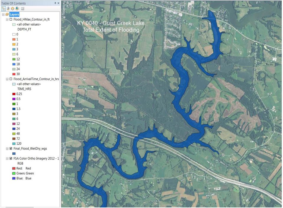
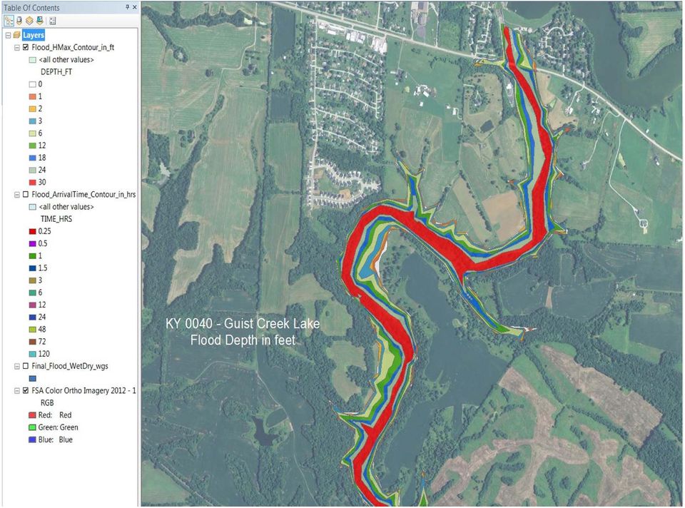
28 KY 0040 GUIST CREEK DAM 60 feet tall 1010 feet wide Area at Normal Pool 317 acres Volume at Normal Pool ac-ft Area at Crest? acres Volume at Crest 15,405.1 ac-ft
29
30
31
32
33
34
35 LESSONS LEARNED Model limitations DSS-WISE-Lite Terrain data is limited to National Elevation Dataset Breach width limited to minimum of 66 feet can effect results NID data needs to be verified when running models (don t rely on accuracy of data because it may have been entered wrong originally when inputted into the NID or corrupt databases could have been used when uploading data into the NID) Transferring data from one model to another (interoperability) Import of hydrographs not currently available in DSS-WISE-Lite Hard to make comparisons if input data can t be compared Export of cross section, WSEL, and/or depth grid data DSS-WISE-Lite is limited to shape files of output Creation of end products EAP are currently unavailable
36 LESSONS LEARNED Top 3 parameters for differences in models Breach Parameters Opinion of inputs varies by user Hydrograph Physical model output HEC-HMS output HEC-RAS inline structure output DSS-WISE-Lite doesn t allow for the input of a breach hydrograph Terrain data 10 meter to 3 meter DEM from National Elevation Dataset (depends on location in the US) 5 feet LIDAR (Kentucky GIS dataset) was used in modeling project Or other terrain data that you may have access to
37 LESSONS LEARNED Volume of Reservoir If the actual volume differs from the volume calculated from the terrain data then the model may not run and an error message will be sent to you by from DSS-WISE-Lite during the error check validation Elevations If known elevations vary from the terrain data then the model may not run and an error message will be sent to you by from DSS-WISE- Lite during the error check validation GIS can be a helpful tool to look at terrain data to verify elevations and volumes but not readily accessible by all users. Bridges If the bridges are in the National Bridge Inventory or you know the location and size, then they can be removed when running DSS-WISE-Lite but there will be some differences in the output of the model since rating curves of bridges are not inputted into model In the instances where there are culverts or bridges at road crossings that are not removed when running DSS-WISE-Lite, the model could show a backwater effect
38 THE RIGHT TOOL FOR THE JOB? If I were cutting trim for my house, which is the right tool?
39 FUTURE ADDITIONAL FEATURES - User can specify a breach width of 33 feet - User can import breach hydrograph - User can develop an Emergency Action Plan We have submitted a paper pertaining to the model comparison study that we (KY Division of Water) did using a FEMA grant to ASDSO that will be coming out in the spring edition of the The Journal of Dam Safety (March 2015).
40 Brian Shane Cook, PE, LSIT Assistant Dam Safety Engineer North Carolina Land Quality Section