INSPIRE D LINKED OPEN DATA TOWARDS
|
|
|
- Justina Malone
- 8 years ago
- Views:
Transcription
1 INSPIRE D LINKED OPEN DATA TOWARDS WATER FRAMEWORK DIRECTIVE ACCOMPLISHMENT ADDRESSING WATER MANAGEMENT SUSTAINABILITY AND INDUCING ECONOMIC GROWTH Maria José Vale, Rui Reis, Bruno M. Meneses, Marcelo Ribeiro, Raquel Saraiva

2 Summary 0. Water Framework Directive: main purpose 1. INSPIRE D Linked Open Data 2. Addressing Water Management sustainability and inducing economic growth: Portuguese and EU Initiatives 3. Linked Open Data/ICT and the new paradigm of good Governance 4. INSPIRE d Towards Good Governance- Water and land management efficiency - economic growth

3 WATER FRAMEWORK DIRECTIVE: MAIN PURPOSE

4 0. WATER FRAMEWORK DIRECTIVE: MAIN PURPOSE ESTABLISHING A FRAMEWORK FOR WATER PROTECTION COVERING THE EU TERRITORY. Economic growth Preservation Water Supply Urban areas Agriculture. Drinking water Cost/benefit Water Stress - Land Use

5 1. INSPIRE D LINKED OPEN DATA

 under an open license b.")
6 1. INSPIRE D LINKED OPEN DATA 1.1 Definition: Open (government) Data and Open (government) Linked Data Adapted from The 5 Stars Model of Tim Berners-Lee a. Open Data Information is available on the Web (any format) under an open license b. Linked Open Data: Information is available as structured data (Non-proprietary formats) Use URL to name (identify) things Data is linked to other data to provide context Publish and refer to other things using HTTP URI URI-based names so that IR can be looked up (interpreted,..) Provide context useful information, using open standards such as RDF, SPARQL, etc. Enable linked Data Platforms

7 1. INSPIRE D LINKED OPEN DATA 1.2 Benefits and Limitations Benefits of Linked Open Data (LOD): 1. Discover new data of interest while consuming other information 2. Access to the data schema 3. Make the data discoverable 4. The value of your data is increased- big data 5. Cost/benefit Limitations of Linked Open Data (LOD): 1. The value of your data is decreased- Entropy 2. Completeness in the context of good governance 3. Reduce the value of the data sets 4. Cost/benefit 5. Safety Let s look to some examples/applications

8 2. ADDRESSING WATER MANAGEMENT SUSTAINABILITY AND INDUCING ECONOMIC GROWTH: Portuguese and EU Initiatives


9 2. WATER MANAGEMENT SUSTAINABILITY AND ECONOMIC GROWTH: Portuguese and EU Initiatives Open Linked Data Water/Land collaborative SDI, in Vale,M Water/Land Water/Land: cooperative land use planning Copyright MariaVale


10 2. WATER MANAGEMENT SUSTAINABILITY AND ECONOMIC GROWTH: Portuguese and EU Initiatives eenvplus Project- main goals: Create an open and interoperable infrastructure to address environmental problems. Atlantic Ocean Portuguese pilot main goals: Territorial management - monitor land cover changes over time - build indicators and monitor urban dynamics. Evaluate fitness for purpose - available datasets - urban growth sustainability evaluation

.")
11 Data harmonization and data quality: Land Cover Data harmonization phases: 1. Study of INSPIRE data specification for land cover; 2. Download of data model xsd format (LandCoverVector); 3. Creation of matching table: 1. Creation of codelists. COS 90 has a wide variety of combinations among the base classes of the nomenclature (eg. UU1, UU2, and so on). This step was important to establish the matching between COS and CLC nomenclatures. 4. Output: GML file created after the harmonization proccess.
.")
")
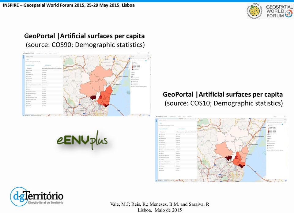
12 GeoPortal Artificial surfaces per capita (source: COS90; Demographic statistics) GeoPortal Artificial surfaces per capita (source: COS10; Demographic statistics)


13 2. WATER MANAGEMENT SUSTAINABILITY AND ECONOMIC GROWTH: Portuguese and EU Initiatives SmartOpendata Project - main goals: Create a Linked Open Data for environmental management in European protected areas. Provide opportunities for SMEs inducing PP/PP/PP partnerships. Portuguese pilot main goals: Portugal-Spain Pilot will focus on building an SDI prototype to promote water and agroforestry management. Built as a collaborative tool for environment protection and economic development of rural areas - key factor is water management and drinking water protection.

14 Linked Open Data (SmOD Project) Public Open Data INSPIRE Geospatial World Forum 2015, May 2015, Lisboa Model of Linked Open Data of the Portuguese Pilot (SmOD Project) and the possible applications LULC t 1 LULC t 2 WQP t 1 WQP t 2 Geomorphologic Data LULC t 1,2 Water Quality Variations by LUCC WQP t 1,2 Environmental Data Applications: Water managementdrinking water Environment research Biodiversity Economic and sustainability progress Governance knowledge Territorial planning (WQP - Water Quality Parameters; LULC Land User and Land Cover; t time)

15 Portugal - Spain Tagus Watershed Zêzere watershed km 2 Important Infrastructure - Castelo de Bode Dam

16 Land Cover Changes CORINE Land Cover, EEA/DGT, 2014 V1.0

17 Portugal - Study Area Zêzere Watershed (5063,7 km 2 )

18 Zêzere Watershed - Land Cover Changes (CORINE Land Cover)


19 Land Cover Changes in Zêzere Watershed (CORINE Land Cover) CLC - Level 1 CLC - Level 2 Water bodies 1.0% Forest and semi natural areas 72.4% CLC 1990 Agricultural areas 25.4% Artificial surfaces 1.2% Water bodies 1.0% Forest and semi natural areas 72.1% CLC 2000 Agricultural areas 25.4% Artificial surfaces 1.4% Urban fabric Scrub and/or herbaceous vegetation associations Permanent crops Pastures Open spaces with little or no vegetation Mine, dump and construction sites CLC 2012 CLC 2006 CLC 2000 Water bodies 1.0% Forest and semi natural areas 72.1% CLC 2006 Agricultural areas 25.3% Artificial surfaces 1.5% Water bodies 1.0% Forest and semi natural areas 72.3% CLC 2012 Agricultural areas 25.0% Artificial surfaces 1.7% Inland waters Industrial, commercial and transport units Heterogeneous agricultural areas Forests Artificial, non-agricultural vegetated areas Arable land Area (%)

20 Metadata: CORINE Land Cover versus COS TABLE 1 Technical specifications between COS2010 and CLC2012

21 Metadata: CORINE Land Cover versus COS TABLE 1 Technical specifications between COS2010 and CLC2012 Designation Carta de Ocupação do Solo 2010 Corine Land Cover 2012 Acronym COS2010 CLC2012 Positional accuracy (scale) 5,5m (1/25 000) 100 m (1/ ) Minimum mapping unit 1ha 25ha Thematic accuracy > 85% (average) > 85% (average) Reference Date Data Model Vector Vector Spatial Representation Polygons Polygons Minimum mapping with 20m 100m Reference Data (Spatial Resolution) Aerial Photographs Satellite Images 50cm 20 m Nomenclature Hierarchical(5 Levels) Hierarchical (3 Levels) 225 Classes 44 Classes Production Method Visual interpretation Visual interpretation
22 Land Cover Changes in Zêzere Watershed CORINE Land Cover versus COS CORINE Land Cover COS
23 Open Data of the Portuguese Pilot (SmOD Project) - Results LULC of Drainage Area of Castelo de Bode Dam (Zêzere Watershed) in Different moments. Area (%) obtained by CLC Data Year LULC Arable land Artificial, non-agricultural vegetated areas Forests Heterogeneous agricultural areas Industrial, commercial and transport units Inland waters Mine, dump and construction sites Open spaces with little or no vegetation Pastures Permanent crops Scrub and/or herbaceous vegetation associations Urban fabric Water Quality Parameters of Castelo de Bode Dam (annual average) WQP Year BDO 5 days (mg/l) Total Lead (mg/l) Total Coliforms (MPN/100ml) Conductivity in laboratory at 20ºC (µs/cm) Color (PtCo) Phenols (mg/l) Total Nitrogen (mg/l NO 3 ) Total Nitrite (mg/l NO 2 ) ph - Field CORRELATION COEFFICIENTS FOR THE WQP IN WATER OF CASTELO DE BODE DAM RESERVOIR AND AREAS OF LULC OF DRAINAGE AREA WQP BDO 5 Total Lead Total Coliforms Conductivity Color Phenols Total days (mg/l) (MPN/100ml) in Laboratory (PtCo) (mg/l) Nitrogen (mg/l) at 20ºC (mg/l Total Nitrite (mg/l NO 2 ) LULC (µs/cm) NO 3 ) Arable land Artificial, non-agricultural vegetated areas Forests Heterogeneous agricultural areas Industrial, commercial and transport units Inland waters Mine, dump and construction sites Open spaces with little or no vegetation Pastures Permanent crops Scrub and/or herbaceous vegetation associations Urban fabric ph - Field
24 3. LINKED OPEN DATA/ICT AND THE NEW PARADIGM OF GOOD GOVERNANCE
25 3. LINKED OPEN DATA/ICT AND THE NEW PARADIGM OF GOOD GOVERNANCE WATER FRAMEWORK DIRECTIVE Data Harmonization (INSPIRE) Availability of metadata (SMOD Viewer) Modeling Artificial Surfaces Growth (Zêzere Watershed) Risk Assessment Models developed for the Zêzere Watershed can be extended to the Tagus river watershed, help building harmonized approaches, addressing Water Framework Directive concerns. Align different EU concerns: Input to INSPIRE and PSI Directives
26 3. Open Data/ICT and the new paradigm of good Governance 3.1 Advantages and Disadvantages based on the principles associated with Open Linked Data 1. Access must be Non-discriminatory : available to anyone, without implying registration.? 2. Data formats must be Non-proprietary: avoiding entities with exclusive control.? 3. Data must be License - Free: The data are not subject to any copyrights, patents, trademarks or secret regulation. A reasonable privacy and privilege and security restrictions may be permitted.? 4. Data must be Accessible: The data should be accessible to a broad user community.? 5. Data must be Primary: Data should be collected at source with the highest level of detail possible, without aggregations or modifications.? 6. Data must be Timely: Available in time - quickly - to preserve value.? 7. Data must be Complete: All public data must be made available. Public data is data that is not subject to privacy restrictions, security or access privileges.? 8. Data must be machine-processable: structured to enable automated processing.?
27 4. INSPIRE D LINKED OPEN DATA TOWARDS WATER FRAMEWORK DIRECTIVE ACCOMPLISHMENT: ADDRESSING WATER MANAGEMENT SUSTAINABILITY AND INDUCING ECONOMIC GROWTH
28 4. INSPIRE d Linked Open Data Towards Water Framework Directive accomplishment Linked Open Data in the public sector: associated with transparency and good governance must integrate this participation with: Responsibility - responsible participation responsible governance Quality - Assured to inform governing decision-making processes Linked data -Fitness for purpose Information -Knowledge Security - People and goods- access to clean water Ethics - Equity and justice Territorial management and resources management -water and land in this case Costs and benefits - efficiency Data collection and data use Partnerships PP-PP-PP. Economic-development-growth SMEs Build the SDI which better respond to territory and water management efficiency inducing economic growth

29 Portuguese Pilot(SmOD) - Propagation Vale, M.J.; Meneses, B.M.; Reis, R.; Saraiva, R.; Estrada, J.; Cruz, M. (2015) - Water Quality Impact Assessment of Land Use and Land Cover Changes. A dynamic IT model for territorial integrated management. Proceedings of the GEOProcessing 2015, Lisbon, pp Meneses, B.M.; Reis, R.; Vale, M.J.; Saraiva, R. (2015) - Land use and land cover changes in Zêzere watershed (Portugal) - water quality implications. Science of the Total Environment, , pp

30 DGT Work Team: Rui Reis, Bruno M. Meneses,Marcelo Ribeiro, Raquel Saraiva Special thanks to the eenvplus and SmartOpendata teams
COS AND LAND USE PLANNING: OPEN DATA TOWARDS PLANNING
 COS AND LAND USE PLANNING: OPEN DATA TOWARDS PLANNING EFFICIENCY R. Saraiva 1, B. M. Meneses 2, M. J. Vale 3, R. Reis 4 1) General Directorate for Territorial Development, Portugal rsaraiva@dgterritorio.pt
MONITORING OF HABITATS AT THE LEVEL OF A NATURA 2000 SITE MOHANA MOBILE AND WEB APP. Francisco Gutierres 1. May of 2016
 MONITORING OF HABITATS AT THE LEVEL OF A NATURA 2000 SITE MOHANA MOBILE AND WEB APP Francisco Gutierres 1 May of 2016 1 Ph.D. in Physical Geography, Institute of Geography Spatial Planning of the University
GetLOD - Linked Open Data and Spatial Data Infrastructures
 GetLOD - Linked Open Data and Spatial Data Infrastructures W3C Linked Open Data LOD2014 Roma, 20-21 February 2014 Stefano Pezzi, Massimo Zotti, Giovanni Ciardi, Massimo Fustini Agenda Context Geoportal
VHR Thematic Maps from Aerospace for Regional and Provincial Urban Planning
 VHR Thematic Maps from Aerospace for Regional and Provincial Urban Planning Massimo Zotti pkm026-428-1.0 Soil loss index Which soil type has been lost in the urban sprawl? Land use 2006 Class description
Applying GIS in seismic hazard assessment and data integration for disaster management
 Applying GIS in seismic hazard assessment and data integration for disaster management Rumiana Vatseva, Dimcho Solakov, Emilia Tcherkezova, Stela Simeonova, Petya Trifonova National Institute of Geophysics,
Big Data Challenge: Mining Heterogeneous Data. Prof. Mihai Datcu. German Aerospace Center (DLR) Munich Aerospace Faculty
 Munich Aerospace Faculty") Big Data Challenge: Mining Heterogeneous Data Prof. Mihai Datcu German Aerospace Center (DLR) Munich Aerospace Faculty Sensing & Big Data Big Data: - Computer hardware and the Cloud - Storage Challenges
Big Data Challenge: Mining Heterogeneous Data Prof. Mihai Datcu German Aerospace Center (DLR) Munich Aerospace Faculty Sensing & Big Data Big Data: - Computer hardware and the Cloud - Storage Challenges
Building a SDI for small countries the Portuguese example
 Building a SDI for small countries the Portuguese example Rui Pedro Julião Instituto Geográfico Português Deputy Director-General rpj@igeo.pt Abstract Portugal was one of the SDI pioneers in the beginning
NSW Government Open Data Policy. September 2013 V1.0. Contact
 NSW Government Open Data Policy September 2013 V1.0 Contact datansw@finance.nsw.gov.au Department of Finance & Services Level 15, McKell Building 2-24 Rawson Place SYDNEY NSW 2000 DOCUMENT CONTROL Document
GMES-DSL GMES - Downstream Service Land: Austria-Slovenia-Andalusia. Concept for a Harmonized Cross-border Land Information System.
 ERA-STAR Regions Project GMES-DSL GMES - Downstream Service Land: Austria-Slovenia-Andalusia. Concept for a Harmonized Cross-border Land Information System Executive Summary submitted by JOANNEUM RESEARCH,
Understanding Raster Data
 Introduction The following document is intended to provide a basic understanding of raster data. Raster data layers (commonly referred to as grids) are the essential data layers used in all tools developed
DFS C2013-6 Open Data Policy
 DFS C2013-6 Open Data Policy Status Current KEY POINTS The NSW Government Open Data Policy establishes a set of principles to simplify and facilitate the release of appropriate data by NSW Government agencies.
European Forest Information and Communication Platform
 1 Metadata Model for the European Forest Information and Communication Platform D. Tilsner 1, C. Figueiredo 1, H. Silva 2, B. Chartier 3, J. San-Miguel 4, A. Camia 4, M. Millot 4 1 EDISOFT, S.A., Lisbon,
The MELODIES project: Exploiting open data using cloud computing and Linked Data
 Dept. of Informatics and Telecommunications, National and Kapodistrian University of Athens, Greece The MELODIES project: Exploiting open data using cloud computing and Linked Data Stella Giannakopoulou
Spatial Data Infrastructure. A Collaborative Network
 Spatial Data Infrastructure A Collaborative Network Solving Challenges Takes Collaboration Social challenges, environmental issues, and economic downturns all take cooperation to solve. Working together
The ORIENTGATE data platform
 Seminar on Proposed and Revised set of indicators June 4-5, 2014 - Belgrade (Serbia) The ORIENTGATE data platform WP2, Action 2.4 Alessandra Nuzzo, Sandro Fiore, Giovanni Aloisio Scientific Computing and
Developments toward a European Land Monitoring Framework. Geoff Smith. Seminar 2 nd December, 2015 Department of Geography, University of Cambridge
 Developments toward a European Land Monitoring Framework Geoff Smith Specto Natura Limited Enable clients to deliver useful, accurate and reliable environmental information from EO. Positioned at the interface
Global environmental information Examples of EIS Data sets and applications
 METIER Graduate Training Course n 2 Montpellier - february 2007 Information Management in Environmental Sciences Global environmental information Examples of EIS Data sets and applications Global datasets
Cadastre in the context of SDI and INSPIRE
 Cadastre in the context of SDI and INSPIRE Dr. Markus Seifert Bavarian Administration for Surveying and Cadastre Cadastre in the digital age the approach in Germany 3 rd CLGE Conference, Hanover, 11.10.2012
THE SPATIAL DATA INFRASTRUCTURE OF SPAIN AS AN EXAMPLE OF SUCCESS IN EUROPE
 THE SPATIAL DATA INFRASTRUCTURE OF SPAIN AS AN EXAMPLE OF SUCCESS IN EUROPE Julio Mezcua-Rodríguez (jmezcua@fomento.es) Instituto Geográfico Nacional (National Geographic Institute). General Ibañez Ibero,
Strategic Activities to Support Sustainability of Canada s Geospatial Data Infrastructure
 Strategic Activities to Support Sustainability of Canada s Geospatial Data Infrastructure Paula McLeod Canada Centre for Mapping and Earth Observation United Nations 10 th Regional Cartographic Conference
A GIS helps you answer questions and solve problems by looking at your data in a way that is quickly understood and easily shared.
 A Geographic Information System (GIS) integrates hardware, software, and data for capturing, managing, analyzing, and displaying all forms of geographically referenced information. GIS allows us to view,
D3.3.1: Sematic tagging and open data publication tools
 COMPETITIVINESS AND INNOVATION FRAMEWORK PROGRAMME CIP-ICT-PSP-2013-7 Pilot Type B WP3 Service platform integration and deployment in cloud infrastructure D3.3.1: Sematic tagging and open data publication
The European Soil Data Center 欧 洲 土 壤 数 据 中 心
 The European Soil Data Center 欧 洲 土 壤 数 据 中 心 Gergely Tóth, Panos Panagos, Marc van Liedekerke,, Luca Montanarella EUROPEAN COMMISSION JOINT RESEARCH CENTRE Institute for Environment and Sustainability
How To Write An Inspire Directive
 INSPIRE Infrastructure for Spatial Information in Europe Detailed definitions on the INSPIRE Network Services Title Detailed definitions on the INSPIRE Network Services Creator Date 2005-07-22 Subject
The Spatial Data Infrastructure of Spain as an example of success in Europe *
 UNITED NATIONS E/CONF.99/IP.16 ECONOMIC AND SOCIAL COUNCIL Ninth United Nations Regional Cartographic Conference for the Americas New York, 10-14 August 2009 Item 7(b) of the provisional agenda Best Practices
Linked Open Data A Way to Extract Knowledge from Global Datastores
 Linked Open Data A Way to Extract Knowledge from Global Datastores Bebo White SLAC National Accelerator Laboratory HKU Expert Address 18 September 2014 Developments in science and information processing
INSPIRE and Multi-Disciplinary Interoperability. Max Craglia European Commission Joint Research Centre
 INSPIRE and Multi-Disciplinary Interoperability Max Craglia European Commission Joint Research Centre www.jrc.ec.europa.eu Serving society Stimulating innovation Supporting legislation Earth system science
An Esri White Paper June 2011 ArcGIS for INSPIRE
 An Esri White Paper June 2011 ArcGIS for INSPIRE Esri, 380 New York St., Redlands, CA 92373-8100 USA TEL 909-793-2853 FAX 909-793-5953 E-MAIL info@esri.com WEB esri.com Copyright 2011 Esri All rights reserved.
Chapter Contents Page No
 Chapter Contents Page No Preface Acknowledgement 1 Basics of Remote Sensing 1 1.1. Introduction 1 1.2. Definition of Remote Sensing 1 1.3. Principles of Remote Sensing 1 1.4. Various Stages in Remote Sensing
The Future of Geospatial Big Data Giovanni Marchisio, Ph.D., Director Product Development
 The Future of Geospatial Big Data Giovanni Marchisio, Ph.D., Director Product Development Nuclear Power Plant, Doel, Belgium December 10, 2011 WorldView-2 Why Geospatial Big Data? We Are the Innovators
Regions of Portugal - Alentejo
 Regions of - Area Why? has the largest land area in mainland 31,605.2 km 2 (1/3 of the national territory), with an international land border of 432 km and a coastline of 179 km Area (km 2 ): 31,604.9
eenvplus - eenvironmental services for advanced applications within INSPIRE
 eenvplus - eenvironmental services for advanced applications within INSPIRE CIP Pilot Actions Grant agreement no: 325232 Starting date: 01 January 2013 Giorgio Saio GISIG Key objective to support INSPIRE
Geospatial Information for disaster risk reduction and natural resources management. Rolando Ocampo Alcántar
 Geospatial Information for disaster risk reduction and natural resources management Rolando Ocampo Alcántar Content Background Geospatial Information for Disaster Management Risk Atlas Information Exchange
CatMDEdit Metadata editor
 Advanced Information Systems Laboratory GeoSpatiumLab S.L. CatMDEdit Metadata editor University of Zaragoza Computer Science and Systems Engineering Department Advanced Information Systems Laboratory (IA3)
Forest Fire Information System (EFFIS): Rapid Damage Assessment
: Rapid Damage Assessment") Forest Fire Information System (EFFIS): Fire Danger D Rating Rapid Damage Assessment G. Amatulli, A. Camia, P. Barbosa, J. San-Miguel-Ayanz OUTLINE 1. Introduction: what is the JRC 2. What is EFFIS 3.
Forest Fire Information System (EFFIS): Fire Danger D Rating Rapid Damage Assessment G. Amatulli, A. Camia, P. Barbosa, J. San-Miguel-Ayanz OUTLINE 1. Introduction: what is the JRC 2. What is EFFIS 3.
Description of the table of the in-situ data requirements of GMES services
 Description of the table of the in-situ data requirements of GMES services 1. In-situ data requirement: Contains short description of each in-situ data (including spatial data) requirement defined by GMES
Wildfire Prevention and Management in a 3D Virtual Environment
 Wildfire Prevention and Management in a 3D Virtual Environment M. Castrillón 1, P.A. Jorge 2, I.J. López 3, A. Macías 2, D. Martín 2, R.J. Nebot 3,I. Sabbagh 3, J. Sánchez 2, A.J. Sánchez 2, J.P. Suárez
SESSION 8: GEOGRAPHIC INFORMATION SYSTEMS AND MAP PROJECTIONS
 SESSION 8: GEOGRAPHIC INFORMATION SYSTEMS AND MAP PROJECTIONS KEY CONCEPTS: In this session we will look at: Geographic information systems and Map projections. Content that needs to be covered for examination
CDI/THREDDS Interoperability: the SeaDataNet developments. P. Mazzetti 1,2, S. Nativi 1,2, 1. CNR-IMAA; 2. PIN-UNIFI
 CDI/THREDDS Interoperability: the SeaDataNet developments P. Mazzetti 1,2, S. Nativi 1,2, 1. CNR-IMAA; 2. PIN-UNIFI Outline Interoperability Issues in SeaDataNet A broker solution for CDI/THREDDS interoperability
ENVIRONMENTAL PLANNING REGIME: REGIONALITY IN THE FOREGROUND
 ENVIRONMENTAL PLANNING REGIME: REGIONALITY IN THE FOREGROUND Róbert ROMÁN Department of Economics and Law, Institute of Economic Science Eszterházy Károly College, Egészségház u. 4, Eger 3300, Hungary
The Role of Spatial Data in EU Agricultural Policy Analysis
 The Role of Spatial Data in EU Agricultural Policy Analysis Wolfgang Britz Institute for Food and Resource Economics, University Bonn Geospatial Open Source Hosting of Agriculture, Resource and Environmental
JRC on 9 November 2009 Biosoil Conference 1. http://forest.jrc.ec.europa.eu/
 JRC on 9 November 2009 Biosoil Conference 1 The European Forest Data Centre (EFDAC) Jesús San-Miguel-Ayanz http://forest.jrc.ec.europa.eu/ Outline FOREST Action 2 1. Role of the European Commission Joint
Mongolian National Spatial Data Infrastructure
 Mongolian National Spatial Data Infrastructure S.Enkhtuya Chief of Spatial Data Infrastructure Department of Administration of Land Affairs, Geodesy and Cartography Beijing. 2014 ORGANIZATIONAL STRUCTURE
Design of Data Management Guideline for Open Data Implementation
 Design of Data Guideline for Implementation (case study in Indonesia) Arry Akhmad Arman Institut Teknologi Bandung Jl. Ganesha 10 Bandung Indonesia 40132 Phone: +62-22-2502260 arry.arman@yahoo.com Gilang
reviewed paper Proceedings REAL CORP 2014 Tagungsband 21-23 May 2014,Vienna, Austria. http://www.corp.at
 reviewed paper Linked Open Data for Environmental Protection in Smart Regions the New Challenge for the Use of Environmental Data and Information Karel Charvat, Sarmite Barvika, Maris Alberts (RNDR., Karel
D3.4.1: Data Fusion Tools
 COMPETITIVINESS AND INNOVATION FRAMEWORK PROGRAMME CIP-ICT-PSP-2013-7 Pilot Type B WP3 Service platform integration and deployment in cloud infrastructure D3.4.1: Data Fusion Tools Deliverable Lead: NETCAD
HYDROLOGICAL CYCLE Vol. I - Anthropogenic Effects on the Hydrological Cycle - I.A. Shiklomanov ANTHROPOGENIC EFFECTS ON THE HYDROLOGICAL CYCLE
 ANTHROPOGENIC EFFECTS ON THE HYDROLOGICAL CYCLE I.A. Shiklomanov Director, State Hydrological Institute, St. Petersburg, Russia Keywords: hydrological cycle, anthropogenic factors, afforestation, land
MASS PROCESSING OF REMOTE SENSING DATA FOR ENVIRONMENTAL EVALUATION IN EUROPE
 MASS PROCESSING OF REMOTE SENSING DATA FOR ENVIRONMENTAL EVALUATION IN EUROPE Lic. Adrián González Applications Research Earth Science Conference 2014 29.07.2014 Earth Science San Conference Francisco
Content. What is Metadata Design and Thing Catalogs INSPIRE and digital Geo Data New Requirement: Pragmatics...and the w holy REST.
 Download: http://arnulf.us/publications/the potential of metadata_foss4g 2010.odp http://arnulf.us/publications/the potential of metadata_foss4g 2010.pdf Content Arnulf Christl What is Metadata Design
3D Point Cloud Analytics for Updating 3D City Models
 3D Point Cloud Analytics for Updating 3D City Models Rico Richter 25 th May 2015 INSPIRE - Geospatial World Forum 2015 Background Hasso Plattner Institute (HPI): Computer Graphics Systems group of Prof.
GIS Initiative: Developing an atmospheric data model for GIS. Olga Wilhelmi (ESIG), Jennifer Boehnert (RAP/ESIG) and Terri Betancourt (RAP)
, Jennifer Boehnert (RAP/ESIG) and Terri Betancourt (RAP)") GIS Initiative: Developing an atmospheric data model for GIS Olga Wilhelmi (ESIG), Jennifer Boehnert (RAP/ESIG) and Terri Betancourt (RAP) Unidata seminar August 30, 2004 Presentation Outline Overview
GIS Initiative: Developing an atmospheric data model for GIS Olga Wilhelmi (ESIG), Jennifer Boehnert (RAP/ESIG) and Terri Betancourt (RAP) Unidata seminar August 30, 2004 Presentation Outline Overview
MODULE 5. MODULE 5: Spatial Data Discovery and Access. www.nlwra.gov.au
 MODULE 5: Spatial Data Discovery and Access Building capacity to implement natural resources information management systems. www.nlwra.gov.au MODULE 5 Table of Contents Guide for managers...ii Context...ii
USE OF GEOSPATIAL AND WEB DATA FOR OECD STATISTICS
 USE OF GEOSPATIAL AND WEB DATA FOR OECD STATISTICS CCSA SPECIAL SESSION ON SHOWCASING BIG DATA 1 OCTOBER 2015 Paul Schreyer Deputy-Director, Statistics Directorate, OECD OECD APPROACH OECD: Facilitator
Contributions of the geospatial fields to monitoring sustainability of urban environments John Trinder. School of Civil and Environmental Engineering
 Contributions of the geospatial fields to monitoring sustainability of urban environments John Trinder School of Civil and Environmental Engineering 2 IMPACT OF HUMAN DEVELOPMENT Humans are modifying the
LinkZoo: A linked data platform for collaborative management of heterogeneous resources
 LinkZoo: A linked data platform for collaborative management of heterogeneous resources Marios Meimaris, George Alexiou, George Papastefanatos Institute for the Management of Information Systems, Research
Spatial Data Infrastructure of the Russian Federation: a new paradigm of openness
 Spatial Data Infrastructure of the Russian Federation: a new paradigm of openness Sergey Sapelnikov, Deputy Chairman of Rosreestr The Federal Service For State Registration, Cadaster and Cartography (ROSREESTR)
Approaches to Making Data Citeable Recommendations of the RDA Working Group. Andreas Rauber, Ari Asmi, Dieter van Uytvanck Stefan Pröll
 Approaches to Making Data Citeable Recommendations of the RDA Working Group Andreas Rauber, Ari Asmi, Dieter van Uytvanck Stefan Pröll Outline Challenges addressed by the WG Recommendation of the RDA Working
CAPAS: A Service for Improving the Assignments of Common Agriculture Policy Funds to Farmers and Land Owners
 CAPAS: A Service for Improving the Assignments of Common Agriculture Policy Funds to Farmers and Land Owners Mariano Navarro 1, Ramón Baiget 1, Jesús Estrada 1 and Dumitru Roman 2 1 TRAGSA Group, Conde
Assessment of Workforce Demands to Shape GIS&T Education
 Assessment of Workforce Demands to Shape GIS&T Education Gudrun Wallentin, Barbara Hofer, Christoph Traun gudrun.wallentin@sbg.ac.at University of Salzburg, Dept. of Geoinformatics Z_GIS, Austria www.gi-n2k.eu
Rural Flooding: The Potential Role of Forestry
 Rural Flooding: The Potential Role of Forestry Nadeem Shah, Tom Nisbet, & Huw Thomas Centre for Forestry and Climate Change Structure Background Woodland and Flood Alleviation The Theory. Studies on Woodland
GIS Data Quality and Evaluation. Tomislav Sapic GIS Technologist Faculty of Natural Resources Management Lakehead University
 GIS Data Quality and Evaluation Tomislav Sapic GIS Technologist Faculty of Natural Resources Management Lakehead University The quality of GIS data gains in importance when considering some of the main
Natural Resource-Based Planning*
 Natural Resource-Based Planning* Planning, when done well, is among the most powerful tools available to communities. A solid plan, based on good natural resource information, guides rational land-use
Introduction to GIS (Basics, Data, Analysis) & Case Studies. 13 th May 2004. Content. What is GIS?
 & Case Studies. 13 th May 2004. Content. What is GIS?") Introduction to GIS (Basics, Data, Analysis) & Case Studies 13 th May 2004 Content Introduction to GIS Data concepts Data input Analysis Applications selected examples What is GIS? Geographic Information
Introduction to GIS (Basics, Data, Analysis) & Case Studies 13 th May 2004 Content Introduction to GIS Data concepts Data input Analysis Applications selected examples What is GIS? Geographic Information
Emerging Trends in SDI.
 Emerging Trends in SDI. Jeanne Foust ESRI gsdi 1 Spatial Data Infrastructure TRENDS GIS use continues to rapidly grow. Recognition Of GIS As Critical Infrastructure growing. Alignment of SDI and National
Panel Remarks by Mr Mmboneni Muofhe, GEO Principal Alternate, Deputy Director General, Department of Science and Technology, South Africa
 UNGGIM- HLF, 20 22 April 2016, Addis Ababa, Ethiopia Session 1: Land Information for Sustainable Development Sub- Session: Addressing challenges confronting countries 20 April 2016: 15h45 17h00 Panel Remarks
Nature Values Screening Using Object-Based Image Analysis of Very High Resolution Remote Sensing Data
 Nature Values Screening Using Object-Based Image Analysis of Very High Resolution Remote Sensing Data Aleksi Räsänen*, Anssi Lensu, Markku Kuitunen Environmental Science and Technology Dept. of Biological
Developments in Turkey in the Context of Participatory Approach Based on River Basin Management. Nermin ÇİÇEK, Özge Hande SAHTİYANCI
 Developments in Turkey in the Context of Participatory Approach Based on River Basin Management Nermin ÇİÇEK, Özge Hande SAHTİYANCI The Ministry of Forestry and Water Affairs, General Directorate of Water
The use of Semantic Web Technologies in Spatial Decision Support Systems
 The use of Semantic Web Technologies in Spatial Decision Support Systems Adam Iwaniak Jaromar Łukowicz Iwona Kaczmarek Marek Strzelecki The INSPIRE Conference 2013, 23-27 June Wroclaw University of Environmental
Historical and projected deforestation rates 1990-2020 for Santo Island / Vanuatu
 INTERNATIONAL CLIMATE INITIATIVE Regional project Climate Protection through Forest Conservation in Pacific Island Countries Historical and projected deforestation rates 1990-2020 for Santo Island / Vanuatu
GeoNetwork, The Open Source Solution for the interoperable management of geospatial metadata
 GeoNetwork, The Open Source Solution for the interoperable management of geospatial metadata Ing. Emanuele Tajariol, GeoSolutions Ing. Simone Giannecchini, GeoSolutions GeoSolutions GeoSolutions GeoNetwork
INPE Spatial Data Infrastructure for Big Spatiotemporal Data Sets. Karine Reis Ferreira (INPE-Brazil)
") INPE Spatial Data Infrastructure for Big Spatiotemporal Data Sets Karine Reis Ferreira (INPE-Brazil) INPE (Brazil) and Big Data I work at INPE (Brazilian National Institute for Space Research). Main gate
INPE Spatial Data Infrastructure for Big Spatiotemporal Data Sets Karine Reis Ferreira (INPE-Brazil) INPE (Brazil) and Big Data I work at INPE (Brazilian National Institute for Space Research). Main gate
The Use of Geographic Information Systems in Risk Assessment
 The Use of Geographic Information Systems in Risk Assessment With Specific Focus on the RiVAMP Methodology Presented by Nadine Brown August 27, 2012 Climate Studies Group Mona Climate Change Workshop Presentation
International Open Data Charter
 International Open Data Charter September 2015 INTERNATIONAL OPEN DATA CHARTER Open data is digital data that is made available with the technical and legal characteristics necessary for it to be freely
SiNErGIC - A NEW APPROACH TO CADASTRE
 SiNErGIC - A NEW APPROACH TO CADASTRE Rui Pedro JULIÃO, Catarina ROQUE and José Pedro NETO, Portugal Key words: Cadastre, Digital Cadastre, e-governance, Information Systems, Portugal SUMMARY Portugal
INSPIRE INfrastructure for SPatial InfoRmation in Europe
 INSPIRE INfrastructure for SPatial InfoRmation in Europe Realisation Aspects at BEV in Austria Dr. techn. Markus Jobst Team INSPIRE/BEV Agenda INSPIRE common understanding at BEV/AT Infrastructure Framework
Data interchange between Web client based task controllers and management information systems using ISO and OGC standards
 Data interchange between Web client based task controllers and management information systems using ISO and OGC standards Michael Nørremark 1*, Ole Jørgensen 1, Jens Bligaard 2 and Claus G. Sørensen 1
RESOURCE EFFICIENCY SCOREBOARD DATA CENTRE ON NATURAL RESOURCES
 RESOURCE EFFICIENCY SCOREBOARD DATA CENTRE ON NATURAL RESOURCES NETGREEN thematic policy workshop 'Maximizing resource efficiency throughout the EU economy' 11 March 2015, CEPS, Brussels Evi Ford-Alexandraki
Technical and innovative tools and methods in support of CAP Geo referencing methods/lpis Polish experience Padova, May 27th 2015
 Technical and innovative tools and methods in support of CAP Geo referencing methods/lpis Polish experience This event is supported by the European Union Programme Hercule III (2014 2020). This programme
LOD 2014 LINKED DATA IN THE CURRICULUM OF THE DILL INTERNATIONAL MASTER
 LOD 2014 LINKED DATA IN THE CURRICULUM OF THE DILL INTERNATIONAL MASTER Anna Maria Tammaro, Universita di Parma Vittore Casarosa, ISTI-CNR, Pisa Carlo Meghini, ISTI-CNR, Pisa Roma 20 Febbraio 2014 DILL
WHAT IS GIS - AN INRODUCTION
 WHAT IS GIS - AN INRODUCTION GIS DEFINITION GIS is an acronym for: Geographic Information Systems Geographic This term is used because GIS tend to deal primarily with geographic or spatial features. Information
GEOGRAPHIC INFORMATION GATEWAY New York Department of State (NYDOS) data acceptance & metadata standards
 data acceptance & metadata standards") GEOGRAPHIC INFORMATION GATEWAY New York Department of State (NYDOS) data acceptance & metadata standards 1. DATA ACCEPTANCE STANDARDS The following describes the data acceptance standards for data included
GEOGRAPHIC INFORMATION GATEWAY New York Department of State (NYDOS) data acceptance & metadata standards 1. DATA ACCEPTANCE STANDARDS The following describes the data acceptance standards for data included
Technology Trends In Geoinformation
 Technology Trends In Geoinformation Dato Prof. Sr Dr. Abdul Kadir Bin Taib Department of Survey and Mapping Malaysia (JUPEM) Email: drkadir@jupem.gov.my www.jupem.gov.my NGIS 2008 3 rd. National GIS Conference
Advanced Image Management using the Mosaic Dataset
 Esri International User Conference San Diego, California Technical Workshops July 25, 2012 Advanced Image Management using the Mosaic Dataset Vinay Viswambharan, Mike Muller Agenda ArcGIS Image Management
CityGML goes to Broadway
 CityGML goes to Broadway Thomas H. Kolbe, Barbara Burger, Berit Cantzler Chair of Geoinformatics thomas.kolbe@tum.de September 11, 2015 Photogrammetric Week 2015, Stuttgart The New York City Open Data
European Soil Data Centre (ESDAC) Marc Van Liedekerke Land Management and Natural Harzards Unit
 Marc Van Liedekerke Land Management and Natural Harzards Unit") European Soil Data Centre (ESDAC) Marc Van Liedekerke Land Management and Natural Harzards Unit 1 Outline 1. What is ESDAC? 2. Requirements 3. Information providers; Inventory 4. ESDAC Repository 5. Implementation
European Soil Data Centre (ESDAC) Marc Van Liedekerke Land Management and Natural Harzards Unit 1 Outline 1. What is ESDAC? 2. Requirements 3. Information providers; Inventory 4. ESDAC Repository 5. Implementation
CHAPTER 5 HB 418-FN FINAL VERSION 2012 SESSION
 Page 1 of 6 CHAPTER 5 HB 418-FN FINAL VERSION 15Mar2011 0733h 01/18/12 0009s 2012 SESSION 11-0741 05/10 HOUSE BILL 418-FN AN ACT relative to the use of open source software and open data formats by state
Data Management Plan. Name of Contractor. Name of project. Project Duration Start date : End: DMP Version. Date Amended, if any
 Data Management Plan Name of Contractor Name of project Project Duration Start date : End: DMP Version Date Amended, if any Name of all authors, and ORCID number for each author WYDOT Project Number Any
Mastering the variety dimension
 Mastering the variety dimension Emanuele Della Valle DEIB - Politecnico di Milano emanuele.dellavalle@polimi.it h>p://emanueledellavalle.org Agenda In a changing world variety is unavoidable SemanEc Technologies
Spatial data quality assessment in GIS
 Recent Advances in Geodesy and Geomatics Engineering Spatial data quality assessment in GIS DANIELA CRISTIANA DOCAN Surveying and Cadastre Department Technical University of Civil Engineering Bucharest
Solutions for Central and Federal Governments
 Solutions for Central and Federal Governments Intergraph s Advanced Geospatial Solutions for for Central and Federal Government Operations Central and federal governments are continually asked to do more
ArcGIS. Server. A Complete and Integrated Server GIS
 ArcGIS Server A Complete and Integrated Server GIS ArcGIS Server A Complete and Integrated Server GIS ArcGIS Server enables you to distribute maps, models, and tools to others within your organization
LJMU Research Data Policy: information and guidance
 LJMU Research Data Policy: information and guidance Prof. Director of Research April 2013 Aims This document outlines the University policy and provides advice on the treatment, storage and sharing of
Interoperable Solutions in Web-based Mapping
 ISPRS SIPT IGU UCI CIG ACSG Table of contents Table des matières Authors index Index des auteurs Search Recherches Exit Sortir Interoperable Solutions in Web-based Mapping Marta Wojnarowska and Bridget
Product Navigator User Guide
 Product Navigator User Guide Table of Contents Contents About the Product Navigator... 1 Browser support and settings... 2 Searching in detail... 3 Simple Search... 3 Extended Search... 4 Browse By Theme...
Architectural Heritage Information System (S.I.P.A.)
") PECSRL 2008 - LANDSCAPES, IDENTITIES AND DEVELOPMENT Óbidos, Portugal, 1-5 September Architectural Heritage Information System (S.I.P.A.) Luís Marques (Geographer) Housing and Urban Rehabilitation Institute
PECSRL 2008 - LANDSCAPES, IDENTITIES AND DEVELOPMENT Óbidos, Portugal, 1-5 September Architectural Heritage Information System (S.I.P.A.) Luís Marques (Geographer) Housing and Urban Rehabilitation Institute
Development of Rural Drinking Water Security Plan A Case Study from Raipur Block, Bhilwara District, Rajasthan
 Development of Rural Drinking Water Security Plan A Case Study from Raipur Block, Bhilwara District, Rajasthan Dr. B. K. Bhadra Scientist/Engr. SF Regional Remote Sensing Centre (RRSC-W) NRSC/ISRO, Dept.
American-Eurasian Journal of Sustainable Agriculture
 Copyright 2015, American-Eurasian Network for Scientific Information publisher American-Eurasian Journal of Sustainable Agriculture ISSN: 1995-0748 JOURNAL home page: http://www.aensiweb.com/aejsa 2015
Technologies Enabling the Evolution of a Smart City. Brad Schmidt, Intergraph Canada
 Technologies Enabling the Evolution of a Smart City Brad Schmidt, Intergraph Canada AGENDA The Smart City Key Challenges Facing Cities Technology Challenges Smart Sensor Integration Smart Apps Smart Data
River Flood Damage Assessment using IKONOS images, Segmentation Algorithms & Flood Simulation Models
 River Flood Damage Assessment using IKONOS images, Segmentation Algorithms & Flood Simulation Models Steven M. de Jong & Raymond Sluiter Utrecht University Corné van der Sande Netherlands Earth Observation