The Future of Geospatial Big Data Giovanni Marchisio, Ph.D., Director Product Development
|
|
|
- Wilfrid Manning
- 8 years ago
- Views:
Transcription
1 The Future of Geospatial Big Data Giovanni Marchisio, Ph.D., Director Product Development Nuclear Power Plant, Doel, Belgium December 10, 2011 WorldView-2

2 Why Geospatial Big Data? We Are the Innovators of Our Industry Geospatial Big Data is the next Frontier! DigitalGlobe Proprietary. (C) DigitalGlobe. All right reserved.

3 DigitalGlobe s global infrastructure provides realtime coverage of over 45% of Earth s land surface Secure data center that processes over 1 billion km 2 of imagery annually and disseminates over multiple networks to thousands of downstream users. 12 Remote Ground Terminals globally with real-time coverage of over 45% of Earth s land surface Secure, 24/7 mission operations center that flies a 6-satellite constellation and supports secure interfaces with US Government DigitalGlobe Proprietary and Confidential 3

 Group Percent Image Ops Image Window Annual Area (sqkm) Annual Capacity Urban Areas 1.50% 2,224,500 100% 52 Year 115,674,000 7% LOC Corridors 3.")
4 DigitalGlobe high performance satellite capacity can address many global missions simultaneously Target Areas Recoverage Rate Applied Capacity Global Land Use Group Percent Land Area Group Area (sqkm) Group Percent Image Ops Image Window Annual Area (sqkm) Annual Capacity Urban Areas 1.50% 2,224, % 52 Year 115,674,000 7% LOC Corridors 3.00% 4,449, % 52 Year 231,348,000 15% Arable Land 13.13% 19,471,790 50% 40 Season 778,871,600 48% Permanent Crops 4.71% 6,984,930 50% 40 Season 279,397,200 17% Permanent Pastures 26.00% 38,558, % 2 Year 77,116,000 5% Forests 32.00% 47,456, % 2 Year 94,912,000 6% Other (e.g., barren) 9.95% 14,755, % 1 Year 14,755,850 1% Antarctica 9.71% 14,399, % 1 Summer 14,399,930 1% Total Land Area > % 148,300,000 1,606,474,580 DigitalGlobe Proprietary and Confidential 4
 9.95% 14,755,850 100% 1 Year 14,755,850 1% Antarctica 9.")
5 What is Geospatial Big Data TM? It is a living digital inventory of the surface of the earth: every structure, vehicle, road, tree, rock, field and patch of dirt It is enabled by DigitalGlobe sability to collect over 1 billion km2 of high resolution satellite imagery every year. It is possible because we can convert this imagery automatically and at scale into searchable, analytics ready information layers. It enables us to answer two kinds of questions: - Show me there tell me everything we know about a particular place; and - Show me where tell me where I need to pay attention. DigitalGlobe Proprietary. (C) DigitalGlobe. All right reserved.

6 How do we compare with other Big Data silos? ~100 Archive Size (Petabytes) 63 ~3 ~3 Facebook Images/Video DigitalGlobe Imagery Netflix Video Walmart Customer Data Sources: Facebook IPO Prospectus, May 2012; Bloomberg, May 2013; SAS, 2012 DigitalGlobe Proprietary. (C) DigitalGlobe. All right reserved.

7 Our Vision: to provide a living digital inventory of everything on the surface of the planet FUSION WITH NON-IMAGE DATA MACHINE LEARNING & CROWDSOURCING + + MODELS & KNOWLEDGE BASES Global A Priory Knowledge Local Hi-res Multitemporal Measurements Local Hi-res Knowledge Global Augmented Knowledge DigitalGlobe Proprietary. (C) DigitalGlobe. All right reserved.
 DigitalGlobe.")
8 We can process and see the world every day Last 24 Hours 8

9 We can process and see the world every day Last 7 Days 9

10 We can process and see the world every day Last 1 Month 10

11 We can process and see the world every day Last 6 Months 11

 DigitalGlobe.")
12 DigitalGlobe Proprietary. (C) DigitalGlobe. All right reserved.

13 Examples of GBD Layers Base Layers Surface Reflectance Country Scale Orthomosaics 3D Terrain Data Very High Resolution LULC Maps Agricultural: field boundaries Agricultural: crop identification Agricultural: crop monitoring Agricultural: crop rotation Forestry: forest acreage determination Forestry: tree species differentiation Geology Maps Objects and Facilities Detection Car, plane, containers counts Parking Lot identification Oil tank detection and measurements Quantifying Human Presence Built-up extent Building footprints Building centroids and areas Population density estimates Village boundaries with population counts Detection of building patterns: slums Detection of new construction Detection of building improvements Disaster and Crisis Management Damaged houses Burned houses Flooded houses Debris fields Downed trees Plane wreckage DigitalGlobe Proprietary. (C) DigitalGlobe. All right reserved.

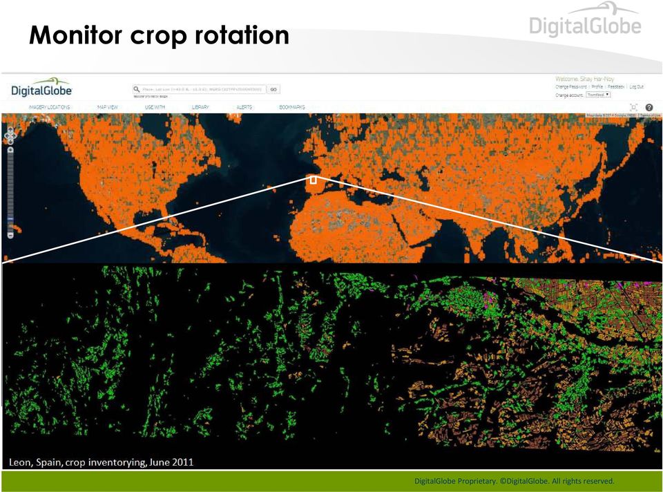
14 Monitor crop rotation
15 Monitor crop rotation 15

16 Monitor factory output 16

17 Monitor factory output 17

18 Monitor factory output 18

19 Identify new construction and new buildings 12/18/

20 Identify new construction and new buildings 09/30/

21 Identify new construction and new buildings New Construction 10/6/
22 Identify new construction and new buildings New Construction 7/11/
23 Identify man-made structures 23
24 Mapping Unchartered Territory in Africa PopCount 125 PopStd 14 PopCount 267 PopStd 31 DigitalGlobe Proprietary. (C) DigitalGlobe. All right reserved.
25 Producing High-res Res Population Density Estimates DigitalGlobe Proprietary. (C) DigitalGlobe. All right reserved.
26 DigitalGlobe Population Density Estimates DigitalGlobe s WV2 (50m cells) DigitalGlobe Proprietary. (C) DigitalGlobe. All right reserved.
27 Producing High-res Res Population Density Estimates DigitalGlobe Proprietary. (C) DigitalGlobe. All right reserved.
28 Population Density Estimates Available Today LandScan (1Km cells) DigitalGlobe Proprietary. (C) DigitalGlobe. All right reserved.


29 But.machine learning is hard Use Humans and Machines! Imagery Automated Processing Crowd CrowdRank TM Expert Analysis Key features Reliability Algorithm 29
30 How might we quickly analyze this image?
31 We could have a human analyst examine it
32 Two analysts would make the job go faster
33 Many analysts would speed it even more
34 Our CrowdRank Technology Develops the Consensus of the Crowd
35 Turning This Image
36 Into This Damage Map, In an Hour
37 which can be searched and analyzed to form useful information Destroyed Property Value = $1.95M
38 MH 370: World s largest crowdsourcing project?
39 Media Frenzy Drives Traffic to DigitalGlobe HTTP Requests per Minute
40 Some impressive statistics CROWD 8 MILLION GUEST USER ACCOUNTS MAPS VIEWED 775 IMAGERY ANALYZED MILLION MAP VIEWS 250 IMAGE STRIPS ANALYZED BY THE CROWD NEW ADDRESSES 911 THOUSAND S CAPTURED@ TAGS SERVER LOAD 14 MILLION TAGS PLACED 500 THOUSAND HTTP REQUESTS PER SECOND

41 Conclusion Through a combination of computer vision, machine learning, crowdsourcing, DigitalGlobe has begun turning large volumes of raw very high resolution imagery into actionable knowledge scaling to state and country sized regions. These dynamically evolving Geospatial Big Data TM layers enable the information and insight applications that will make us, by 2020, the indispensable source of information about our changing planet. DigitalGlobe Proprietary. (C) DigitalGlobe. All right reserved. DigitalGlobe Proprietary and Business Confidential
42
May 2013 Oracle Spatial and Graph User Conference
 1 May 2013 Oracle Spatial and Graph User Conference May 22, 2013 Ronald Reagan Building and International Trade Center Washington, DC USA Paul Welding Sr. Manager Software Development Imagery Inventory
The following was presented at DMT 14 (June 1-4, 2014, Newark, DE).
.") DMT 2014 The following was presented at DMT 14 (June 1-4, 2014, Newark, DE). The contents are provisional and will be superseded by a paper in the DMT 14 Proceedings. See also presentations and Proceedings
DMT 2014 The following was presented at DMT 14 (June 1-4, 2014, Newark, DE). The contents are provisional and will be superseded by a paper in the DMT 14 Proceedings. See also presentations and Proceedings
GEOSPATIAL DIGITAL ASSET MANAGEMENT A SOLUTION INTEGRATING IMAGERY AND GIS WHERE WILL ALL THE PIXELS GO?(AND HOW WILL WE EVER FIND THEM?
 GEOSPATIAL DIGITAL ASSET MANAGEMENT A SOLUTION INTEGRATING IMAGERY AND GIS WHERE WILL ALL THE PIXELS GO?(AND HOW WILL WE EVER FIND THEM?) Dr. Joan Lurie, GCC, Inc. 30 West 61 st Street, Apt 9A New York,
COASTAL MONITORING & OBSERVATIONS LESSON PLAN Do You Have Change?
 Coastal Change Analysis Lesson Plan COASTAL MONITORING & OBSERVATIONS LESSON PLAN Do You Have Change? NOS Topic Coastal Monitoring and Observations Theme Coastal Change Analysis Links to Overview Essays
German Earth Observation Systems and Programs Capacities for nation building
 German Earth Observation Systems and Programs Capacities for nation building German Aerospace Center, DLR, Earth Observation Center, EOC German Remote Sensing Data Center, DFD Gunter Schreier Deputy Director
Point Clouds: Big Data, Simple Solutions. Mike Lane
 Point Clouds: Big Data, Simple Solutions Mike Lane Light Detection and Ranging Point Cloud is the Third Type of Data Vector Point Measurements and Contours Sparse, highly irregularly spaced X,Y,Z values
AERIAL PHOTOGRAPHS. For a map of this information, in paper or digital format, contact the Tompkins County Planning Department.
 AERIAL PHOTOGRAPHS What are Aerial Photographs? Aerial photographs are images of the land taken from an airplane and printed on 9 x9 photographic paper. Why are Aerial Photographs Important? Aerial photographs
The Challenges of Geospatial Analytics in the Era of Big Data
 The Challenges of Geospatial Analytics in the Era of Big Data Dr Noordin Ahmad National Space Agency of Malaysia (ANGKASA) CITA 2015: 4-5 August 2015 Kuching, Sarawak Big datais an all-encompassing term
Mr. Jay Arnold, Magnolia River Mr. Richard Vincent, McKim & Creed
 Mr. Jay Arnold, Magnolia River Mr. Richard Vincent, McKim & Creed Why Change? Electric Utility Safety and Reliability NERC FAC- 008 and FAC-003 As Built Infrastructure monitor vegetation annual requirement
The needs on big data management for Operational Geo-Info Services: Emergency Response, Maritime surveillance, Agriculture Management
 Copernicus Big-Data Workshop 2014, 13/14 March The needs on big data management for Operational Geo-Info Services: Emergency Response, Maritime surveillance, Agriculture Management Marco Corsi e-geos 1
Geospatial Software Solutions for the Environment and Natural Resources
 Geospatial Software Solutions for the Environment and Natural Resources Manage and Preserve the Environment and its Natural Resources Our environment and the natural resources it provides play a growing
Tools and Methods for Global Urban Analysis
 European Commission Joint Research Centre 1st Urbanization Workshop Day 2, Session 1: Tools and Methods for Global Urban Analysis Ellen Hamilton Lead Urban Specialist World Bank 1 Outline Global Agendas:
16 URBAN VISUALIZATION MODELLING
 16 URBAN VISUALIZATION MODELLING The Planning and Economic Development Committee recommends the adoption of the recommendation contained in the following report August 23, 2006, from the Commissioner of
Hyperspectral Satellite Imaging Planning a Mission
 Hyperspectral Satellite Imaging Planning a Mission Victor Gardner University of Maryland 2007 AIAA Region 1 Mid-Atlantic Student Conference National Institute of Aerospace, Langley, VA Outline Objective
Demystifying CLOUD COMPUTING
 Demystifying CLOUD COMPUTING for Remote Sensing Applications Cloud computing is a powerful, unique value proposition that can transform massive Earth imagery datasets into useful information for users
3D Point Cloud Analytics for Updating 3D City Models
 3D Point Cloud Analytics for Updating 3D City Models Rico Richter 25 th May 2015 INSPIRE - Geospatial World Forum 2015 Background Hasso Plattner Institute (HPI): Computer Graphics Systems group of Prof.
Enterprise Social Networking Technology Embracing a New Competitive Advantage Strategy. A White Paper
 Enterprise Social Networking Technology Embracing a New Competitive Advantage Strategy A White Paper Introduction In these dynamic economic times doing more with less has become the norm. Demanding customers
Applications of Deep Learning to the GEOINT mission. June 2015
 Applications of Deep Learning to the GEOINT mission June 2015 Overview Motivation Deep Learning Recap GEOINT applications: Imagery exploitation OSINT exploitation Geospatial and activity based analytics
2.3 Spatial Resolution, Pixel Size, and Scale
 Section 2.3 Spatial Resolution, Pixel Size, and Scale Page 39 2.3 Spatial Resolution, Pixel Size, and Scale For some remote sensing instruments, the distance between the target being imaged and the platform,
The Use of Geographic Information Systems in Risk Assessment
 The Use of Geographic Information Systems in Risk Assessment With Specific Focus on the RiVAMP Methodology Presented by Nadine Brown August 27, 2012 Climate Studies Group Mona Climate Change Workshop Presentation
Global environmental information Examples of EIS Data sets and applications
 METIER Graduate Training Course n 2 Montpellier - february 2007 Information Management in Environmental Sciences Global environmental information Examples of EIS Data sets and applications Global datasets
The USGS Landsat Big Data Challenge
 The USGS Landsat Big Data Challenge Brian Sauer Engineering and Development USGS EROS bsauer@usgs.gov U.S. Department of the Interior U.S. Geological Survey USGS EROS and Landsat 2 Data Utility and Exploitation
GEOGRAPHIC INFORMATION SYSTEMS
 GEOGRAPHIC INFORMATION SYSTEMS WHAT IS A GEOGRAPHIC INFORMATION SYSTEM? A geographic information system (GIS) is a computer-based tool for mapping and analyzing spatial data. GIS technology integrates
MASS PROCESSING OF REMOTE SENSING DATA FOR ENVIRONMENTAL EVALUATION IN EUROPE
 MASS PROCESSING OF REMOTE SENSING DATA FOR ENVIRONMENTAL EVALUATION IN EUROPE Lic. Adrián González Applications Research Earth Science Conference 2014 29.07.2014 Earth Science San Conference Francisco
Earth Data Science in The Era of Big Data and Compute
 Earth Data Science in The Era of Big Data and Compute E. Lynn Usery U.S. Geological Survey usery@usgs.gov http://cegis.usgs.gov U.S. Department of the Interior U.S. Geological Survey Board on Earth Sciences
THE INSTITUTE FOR ENVIRONMENTAL ANALYTICS
 THE INSTITUTE FOR ENVIRONMENTAL ANALYTICS Jon Blower Director of Science j.blower@the-iea.org 1 KEY FACTS 13m funding over initial 5-year period 2015 2020 (HEFCE Catalyst funding and founding partners)
Connected Services. New Manufacturing Models Increase Revenue Growth. Authors Kevin Sullivan Ram Muthukrishnan. April 2013
 Connected Services New Manufacturing Models Increase Revenue Growth Authors Kevin Sullivan Ram Muthukrishnan April 2013 Cisco Internet Business Solutions Group (IBSG) Cisco IBSG 2013 Cisco and/or its affiliates.
Liberia Forest Mapping. World Bank January 2012
 Liberia Forest Mapping World Bank January 2012 Scope of presentation 1. Overview (5 min) 2. Service presentation (20 min) 3. Operational scenario (10min) 4. Service Utility Review (45 min) 5. Wrap-up and
Geospatial intelligence and data fusion techniques for sustainable development problems
 Geospatial intelligence and data fusion techniques for sustainable development problems Nataliia Kussul 1,2, Andrii Shelestov 1,2,4, Ruslan Basarab 1,4, Sergii Skakun 1, Olga Kussul 2 and Mykola Lavreniuk
USING ANALYTICS TO IMPROVE SUPPLY CHAIN PERFORMANCE
 USING ANALYTICS TO IMPROVE SUPPLY CHAIN PERFORMANCE MICHAEL R. GALBRETH, PH.D. USC/SYRACUSE SUPPLY CHAIN IMPROVEMENT CONFERENCE, OCT. 2014 HIPPO If we have data, let s look at data. If all we have are
Bhuvan. Indian Earth Observation Visualization. Indian Space Research Organisation. http://bhuvan.nrsc.gov.in. Multi Resolution. Societal Applications
 Multi Resolution Bhuvan Societal Applications Indian Earth Observation Visualization http://bhuvan.nrsc.gov.in 3D Geographic Models Seamless Fly Through Indian Space Research Organisation Thematic Vectors
Video Analytics and Security
 Video Analytics and Security Video Analytics and Security Using video data to improve both safety and ROI TABLE OF CONTENTS I. Executive Summary... 1 II. Captured on Video. Now What?... 2 III. Start Where
Moderate- and high-resolution Earth Observation data based forest and agriculture monitoring in Russia using VEGA Web-Service
 Moderate- and high-resolution Earth Observation data based forest and agriculture monitoring in Russia using VEGA Web-Service Sergey BARTALEV and Evgeny LOUPIAN Space Research Institute, Russian Academy
Providing On-Demand Situational Awareness
 ITT Exelis Geospatial Intelligence Solutions Providing On-Demand Situational Awareness Use of U.S. Department of Defense (DoD) and U.S. Army imagery in this brochure does not constitute or imply DoD or
The Internet of Things. Giles Norman MobileFirst Consulting Manager, IBM. Daniel Dombach Director EMEA, Industry Solutions, Zebra Technologies
 The Internet of Things Giles Norman MobileFirst Consulting Manager, IBM Daniel Dombach Director EMEA, Industry Solutions, Zebra Technologies Internet of Things Daniel Dombach Director EMEA Industry Solutions
APFO Data Provisioning and Services
 Who We Are APFO is the primary source of aerial imagery for the U.S. Department of Agriculture. Data Stewards for NAIP, and historical aerial photography collected for USDA dating back to 1955. Who We
Connecting the World from the Sky
 Connecting the World from the Sky Last August, Facebook partnered with leading technology companies to launch Internet.org a global effort to make affordable basic internet services available to everyone
ABSTRACT INTRODUCTION PURPOSE
 EVALUATION OF TSUNAMI DISASTER BY THE 2011 OFF THE PACIFIC COAST OF TOHOKU EARTHQUAKE IN JAPAN BY USING TIME SERIES SATELLITE IMAGES WITH MULTI RESOLUTION Hideki Hashiba Associate Professor Department
FedEx, Rolls Royce and UPS know And so do Google, Facebook, Amazon and Intel
 FedEx, Rolls Royce and UPS know And so do Google, Facebook, Amazon and Intel The next great U.S. industrial cycle AUVSI s 2013 Economic Report: www.auvsi.org/econreport The UAS global market is currently
.FOR. Forest inventory and monitoring quality
 .FOR Forest inventory and monitoring quality FOR : the asset to manage your forest patrimony 2 1..FOR Presentation.FOR is an association of Belgian companies, created in 2010 and supported by a university
APPLICATION OF GOOGLE EARTH FOR THE DEVELOPMENT OF BASE MAP IN THE CASE OF GISH ABBAY SEKELA, AMHARA STATE, ETHIOPIA
 APPLICATION OF GOOGLE EARTH FOR THE DEVELOPMENT OF BASE MAP IN THE CASE OF GISH ABBAY SEKELA, AMHARA STATE, ETHIOPIA Abineh Tilahun Department of Geography and environmental studies, Adigrat University,
Agricultural Production and Research in Heilongjiang Province, China. Jiang Enchen. Professor, Department of Agricultural Engineering, Northeast
 1 Agricultural Production and Research in Heilongjiang Province, China Jiang Enchen Professor, Department of Agricultural Engineering, Northeast Agricultural University, Harbin, China. Post code: 150030
Project Title: Project PI(s) (who is doing the work; contact Project Coordinator (contact information): information):
 (who is doing the work; contact Project Coordinator (contact information): information):") Project Title: Great Northern Landscape Conservation Cooperative Geospatial Data Portal Extension: Implementing a GNLCC Spatial Toolkit and Phenology Server Project PI(s) (who is doing the work; contact
Project Title: Great Northern Landscape Conservation Cooperative Geospatial Data Portal Extension: Implementing a GNLCC Spatial Toolkit and Phenology Server Project PI(s) (who is doing the work; contact
Visual Sensing and Analytics for Construction and Infrastructure Management
 Visual Sensing and Analytics for Construction and Infrastructure Management Academic Committee Annual Conference Speaker Moderator: Burcu Akinci, Carnegie Mellon University 2015 CII Annual Conference August
Global Climate Change: Carbon Reporting Initiative
 United States Agency for International Development Cooperative Agreement No. EEM-A-00-06-00024-00 Global Climate Change: Carbon Reporting Initiative January 2012 Submitted by: Nancy Harris Ecosystem Services
Alternative Energy Resources
 Alternative Energy Resources Energy Resource Advantages Disadvantages What are some renewable energy resources? A nonrenewable resource cannot be replaced in a reasonable amount of time. Fossil fuels such
ArcGIS Agricultural Land Use Maps from the Mississippi Cropland Data Layer
 ArcGIS Agricultural Land Use Maps from the Mississippi Cropland Data Layer Fred L. Shore, Ph.D. Mississippi Department of Agriculture and Commerce Jackson, MS, USA fred_shore@nass.usda.gov Rick Mueller
The Big Data Paradigm Shift. Insight Through Automation
 The Big Data Paradigm Shift Insight Through Automation Agenda The Problem Emcien s Solution: Algorithms solve data related business problems How Does the Technology Work? Case Studies 2013 Emcien, Inc.
Texas Prairie Wetlands Project (TPWP) Performance Monitoring
 Performance Monitoring") Texas Prairie Wetlands Project (TPWP) Performance Monitoring Relationship to Gulf Coast Joint Venture (GCJV) Habitat Conservation: Priority Species: Wintering waterfowl species in the Texas portion of
Texas Prairie Wetlands Project (TPWP) Performance Monitoring Relationship to Gulf Coast Joint Venture (GCJV) Habitat Conservation: Priority Species: Wintering waterfowl species in the Texas portion of
Emerging Geospatial Trends The Convergence of Technologies. Jim Steiner Vice President, Product Management
 Emerging Geospatial Trends The Convergence of Technologies Jim Steiner Vice President, Product Management United Nation Analysis Initiative on Global GeoSpatial Information Management Future Trends Technology
The Wildland-Urban Interface in the United States
 The Wildland-Urban Interface in the United States Susan I. Stewart Northern Research Station, USDA Forest Service, Evanston, IL (sistewart@fs.fed.us) Volker C. Radeloff Department of Forestry, University
Remote Sensing and GIS Application In Change Detection Study In Urban Zone Using Multi Temporal Satellite
 Remote Sensing and GIS Application In Change Detection Study In Urban Zone Using Multi Temporal Satellite R.Manonmani, G.Mary Divya Suganya Institute of Remote Sensing, Anna University, Chennai 600 025
How To Manage Assets With Geospatially Enabled Asset Management
 Point of view Geospatially enhanced asset management: Everything in its place "Geospatially enabled asset management uses the power of location not only to properly value and utilize assets, but also as
APPLICATION OF GEOSPATIAL TECHNOLOGIES FOR SUSTAINABLE ENVIRONMENTAL MANAGEMENT
 APPLICATION OF GEOSPATIAL TECHNOLOGIES FOR SUSTAINABLE NATURAL RESOURCES AND ENVIRONMENTAL MANAGEMENT IN MALAYSIA By James Dawos Mamit, Ph.D. Deputy Minister Ministry of Natural Resources and Environment,
Review for Introduction to Remote Sensing: Science Concepts and Technology
 Review for Introduction to Remote Sensing: Science Concepts and Technology Ann Johnson Associate Director ann@baremt.com Funded by National Science Foundation Advanced Technological Education program [DUE
GIS BASED LAND INFORMATION SYSTEM FOR MANDAL SOUM, SELENGE AIMAG OF MONGOLIA
 GIS BASED LAND INFORMATION SYSTEM FOR MANDAL SOUM, SELENGE AIMAG OF MONGOLIA B. Tuul GTZ, Land Management and Fiscal Cadastre project, Government building 12, ALAGCaC, Ulaanbaatar, Mongolia tuul1119@yahoo.com,
GIT Geology and Information Technology
 Luca Fallati Università degli Studi di Milano-Bicocca: MaRHE Marine Research and High Educational Centre Land Use Changes (LUC) in developing countries are: - faster and widespread; - often not surveyed
Google Earth Digitale Wege in eine bekannte Welt Sep. 2006
 Google Earth Digitale Wege in eine bekannte Welt Sep. 2006 Joachim Glaubrecht Google Enterprise joachim@google.com What is Google Enterprise? 2 1 Focus.de: "Der Papst-Besuch in Google Earth" 3 How to Geo
Critical Asset Protection Oil and Gas Protection
 Critical Asset Protection Oil and Gas Protection Our Oil & Gas Protection project in the Middle-East features Wisdom Command and Control (C2) system that uses unique correlation algorithms to integrate
Strategic Activities to Support Sustainability of Canada s Geospatial Data Infrastructure
 Strategic Activities to Support Sustainability of Canada s Geospatial Data Infrastructure Paula McLeod Canada Centre for Mapping and Earth Observation United Nations 10 th Regional Cartographic Conference
OBJECT BASED IMAGE CLASSIFICATION AND WEB-MAPPING TECHNIQUES FOR FLOOD DAMAGE ASSESSMENT
 OBJECT BASED IMAGE CLASSIFICATION AND WEB-MAPPING TECHNIQUES FOR FLOOD DAMAGE ASSESSMENT Ejaz Hussain, KyoHyouk Kim, Jie Shan {ehussain, kim458, jshan}@ecn.purdue.edu Geomatics Engineering, School of Civil
Technologies Enabling the Evolution of a Smart City. Brad Schmidt, Intergraph Canada
 Technologies Enabling the Evolution of a Smart City Brad Schmidt, Intergraph Canada AGENDA The Smart City Key Challenges Facing Cities Technology Challenges Smart Sensor Integration Smart Apps Smart Data
Global Positioning System (GPS) Automated Vehicle Location (AVL) Geographic Information System (GIS) and Routing/Scheduling System
 Automated Vehicle Location (AVL) Geographic Information System (GIS) and Routing/Scheduling System") Global Positioning System (GPS) Automated Vehicle Location (AVL) Geographic Information System (GIS) and Routing/Scheduling System Jeff Tsai Program Director Institute for Transportation Research and Education
Global Positioning System (GPS) Automated Vehicle Location (AVL) Geographic Information System (GIS) and Routing/Scheduling System Jeff Tsai Program Director Institute for Transportation Research and Education
Cyber Impact Assessment for Space Mission Assurance
 Cyber Impact Assessment for Space Mission Assurance Presented by: Douglas Wiemer d.wiemer@rheagroup.com Mission and system taxonomy contribution: Cédric Seynat cseynat@rheagroup.ca 18 June 2013 1 1 Topics
Technology Implications of an Instrumented Planet presented at IFIP WG 10.4 Workshop on Challenges and Directions in Dependability
 Technology Implications of an Instrumented Planet presented at IFIP WG 10.4 Workshop on Challenges and Directions in Dependability Nick Bowen Colin Harrison IBM June 2008 1 Background Global Technology
WHAT IS GIS - AN INRODUCTION
 WHAT IS GIS - AN INRODUCTION GIS DEFINITION GIS is an acronym for: Geographic Information Systems Geographic This term is used because GIS tend to deal primarily with geographic or spatial features. Information
Setting the Standard for Safe City Projects in the United States
 Leading Safe Cities Setting the Standard for Safe City Projects in the United States Edge360 is a provider of Safe City solutions to State & Local governments, helping our clients ensure they have a secure,
Learn How to Fly a Gatewing X-100 and Why
 The Trimble Gatewing Rapid mapping tool. TSA Discussion Group, 7 Nov 2012 Anthony Mills, Trimble Agenda: Why UAS? Gatewing Results Deliverables Accuracy UK Regulation Why UAS? Economic Hazardous & Hard-to-Reach
Monitoring Overview with a Focus on Land Use Sustainability Metrics
 Monitoring Overview with a Focus on Land Use Sustainability Metrics Canadian Roundtable for Sustainable Crops. Nov 26, 2014 Agriclimate, Geomatics, and Earth Observation Division (ACGEO). Presentation
Adaptation of High Resolution Ikonos Images to Googleearth for Zonguldak Test Field
 Adaptation of High Resolution Ikonos Images to Googleearth for Zonguldak Test Field Umut G. SEFERCIK, Murat ORUC and Mehmet ALKAN, Turkey Key words: Image Processing, Information Content, Image Understanding,
Land Use/Land Cover Map of the Central Facility of ARM in the Southern Great Plains Site Using DOE s Multi-Spectral Thermal Imager Satellite Images
 Land Use/Land Cover Map of the Central Facility of ARM in the Southern Great Plains Site Using DOE s Multi-Spectral Thermal Imager Satellite Images S. E. Báez Cazull Pre-Service Teacher Program University
RESOLUTION MERGE OF 1:35.000 SCALE AERIAL PHOTOGRAPHS WITH LANDSAT 7 ETM IMAGERY
 RESOLUTION MERGE OF 1:35.000 SCALE AERIAL PHOTOGRAPHS WITH LANDSAT 7 ETM IMAGERY M. Erdogan, H.H. Maras, A. Yilmaz, Ö.T. Özerbil General Command of Mapping 06100 Dikimevi, Ankara, TURKEY - (mustafa.erdogan;
Security Systems EMERGENCY MANAGEMENT. In security you cannot choose the second best option. indracompany.com
 Security Systems EMERGENCY MANAGEMENT In security you cannot choose the second best option indracompany.com EMERGENCY MANAGEMENT EMERGENCY MANAGEMENT EMERGENCY C4i CENTRE Crisis management and preparednesss
U.S. COMMERCIAL REMOTE SENSING POLICY. April 25, 2003 FACT SHEET
 U.S. COMMERCIAL REMOTE SENSING POLICY April 25, 2003 FACT SHEET The President authorized a new national policy on April 25, 2003 that establishes guidance and implementation actions for commercial remote
Enabling RTK-like positioning offshore using the global VERIPOS GNSS network. Pieter Toor GNSS Technology Manager
 Enabling RTK-like positioning offshore using the global VERIPOS GNSS network Pieter Toor GNSS Technology Manager Introduction PPP/RTK Positioning Techniques PPP-AR Technology Presentation Overview PPP-AR
Climate Change: A Local Focus on a Global Issue Newfoundland and Labrador Curriculum Links 2010-2011
 Climate Change: A Local Focus on a Global Issue Newfoundland and Labrador Curriculum Links 2010-2011 HEALTH Kindergarten: Grade 1: Grade 2: Know that litter can spoil the environment. Grade 3: Grade 4:
Analyzing HTTP/HTTPS Traffic Logs
 Advanced Threat Protection Automatic Traffic Log Analysis APTs, advanced malware and zero-day attacks are designed to evade conventional perimeter security defenses. Today, there is wide agreement that
Monitoring Wetland Changes Using Multitemporal Landsat Change Detection, Web Mapping Services, and Crowd Sourcing
 Monitoring Wetland Changes Using Multitemporal Landsat Change Detection, Web Mapping Services, and Crowd Sourcing Presented By: Mary Latiolais Outline The Vision: Crowd sourcing to document and reduce
Environment Monitoring Services for Humanitarian & Security situations.
 Cesar Harada, Open-H2O group Environment, Technology, Strategy and Design contact@protei.org Environment Monitoring Services for Humanitarian & Security situations. Aerial photography mapping and infrared
Statements of member companies within The Green Grid
 Statements of member companies within The Green Grid In support of COP21, the White House is gathering commitments from companies across the American economy that are willing to join the American Business
Technology Trends In Geoinformation
 Technology Trends In Geoinformation Dato Prof. Sr Dr. Abdul Kadir Bin Taib Department of Survey and Mapping Malaysia (JUPEM) Email: drkadir@jupem.gov.my www.jupem.gov.my NGIS 2008 3 rd. National GIS Conference
Extraction of Satellite Image using Particle Swarm Optimization
 Extraction of Satellite Image using Particle Swarm Optimization Er.Harish Kundra Assistant Professor & Head Rayat Institute of Engineering & IT, Railmajra, Punjab,India. Dr. V.K.Panchal Director, DTRL,DRDO,
BLACKBRIDGE SATELLITE IMAGERY THROUGH CLOUD COMPUTING
 BLACKBRIDGE SATELLITE IMAGERY THROUGH CLOUD COMPUTING Jason Setzer Cloud Product Manager Slide 1 THE RAPID EYE CONSTELLATION 5 Identical Satellites in same obit Up to 5 million km² collected daily 1 billion
Satellite Monitoring of Urbanization in Megacities
 Satellite Monitoring of Urbanization in Megacities Yifang Ban Professor of Geoinformatics Department of Urban Planning & Environment KTH Royal Institute of Technology Stockholm, Sweden Introduction In
Igniting the Next Industrial Revolution
 Igniting the Next Industrial Revolution Defining an M2M Technology Platform for the Industrial Internet M2M Evolution Conference, 30 Jan 2014 Nikhil Chauhan Director Product Marketing, GE Software Sufficiently
Repair of Fences Damaged by Bushfire and Fire Control Line Rehabilitation Policy
 Repair of Fences Damaged by Bushfire and Fire Control Line Rehabilitation Policy Contents Contents 1 1.0 Purpose 2 1.1 Background 2 1.2 Purpose 2 2.0 Scope 2 3.0 Principles / Policy 3 3.1 Damage to private
Unit 6: Homework Questions
 1. The most sustainable type of development is: A) dispersed development B) compact development C) satellite development D) corridor development E) strip development 2. Urban sprawl is synonymous with
Operational Space- Based Crop Mapping Protocols at AAFC A. Davidson, H. McNairn and T. Fisette.
 Operational Space- Based Crop Mapping Protocols at AAFC A. Davidson, H. McNairn and T. Fisette. Science & Technology Branch. Agriculture and Agri-Food Canada. 1. Introduction Space-Based Crop Mapping at
Geospatial Imaging Cloud Storage Capturing the World at Scale with WOS TM. ddn.com. DDN Whitepaper. 2011 DataDirect Networks. All Rights Reserved.
 DDN Whitepaper Geospatial Imaging Cloud Storage Capturing the World at Scale with WOS TM Table of Contents Growth and Complexity Challenges for Geospatial Imaging 3 New Solutions to Drive Insight, Simplicity
How To Handle Big Data With A Data Scientist
 III Big Data Technologies Today, new technologies make it possible to realize value from Big Data. Big data technologies can replace highly customized, expensive legacy systems with a standard solution
A SEISMIC OIL AND GAS PRIMER by Kevin B. Hill
 A SEISMIC OIL AND GAS PRIMER by Kevin B. Hill Hill Geophysical Consulting 415 Texas Street, Suite 200 Shreveport, LA 71101 318.221 3329 hillgeop@gte.net 1) What is seismic data? Outline 2) How is seismic
Types of Engineering Jobs
 What Do Engineers Do? Engineers apply the theories and principles of science and mathematics to the economical solution of practical technical problems. I.e. To solve problems Often their work is the link
LogInspect 5 Product Features Robust. Dynamic. Unparalleled.
 LogInspect 5 Product Features Robust. Dynamic. Unparalleled. Enjoy ultra fast search capabilities in simple and complex modes optimized for Big Data Easily filter and display relevant topics, eg: Top 10
the Cloud Dean McCormick Regional Sales Manager Geospatial MEA Region
 Powering Big Data: From Creation to the Cloud Dean McCormick Regional Sales Manager Geospatial MEA Region The only constant is change, continuing change, inevitable change, that is the dominant factor
Capture Your Assets (CYA) Data Retention Policies in E&P
 Data Retention Policies in E&P") 1 Capture Your Assets (CYA) Data Retention Policies in E&P By Suzi Hutchinson, Sr. Product Manager, Information Management, and Janet Hicks, Sr. Manager, Information Management Presented at Petroleum Network
1 Capture Your Assets (CYA) Data Retention Policies in E&P By Suzi Hutchinson, Sr. Product Manager, Information Management, and Janet Hicks, Sr. Manager, Information Management Presented at Petroleum Network
Impact of Big Data in Oil & Gas Industry. Pranaya Sangvai Reliance Industries Limited 04 Feb 15, DEJ, Mumbai, India.
 Impact of Big Data in Oil & Gas Industry Pranaya Sangvai Reliance Industries Limited 04 Feb 15, DEJ, Mumbai, India. New Age Information 2.92 billions Internet Users in 2014 Twitter processes 7 terabytes
Land Use/ Land Cover Mapping Initiative for Kansas and the Kansas River Watershed
 Land Use/ Land Cover Mapping Initiative for Kansas and the Kansas River Watershed Kansas Biological Survey Kansas Applied Remote Sensing Program April 2008 Previous Kansas LULC Projects Kansas LULC Map
Network Traffic Management under Disaster Conditions. Hediye Tuydes PhD Candidate Northwestern University
 Network Traffic Management under Disaster Conditions by Hediye Tuydes PhD Candidate Northwestern University Motivation Most Common Disasters Natural Earthquakes Hurricanes Floods Volcanic eruptions Fires
Empowering Wholesale Customers: WWAN/ Machine to Machine APR 2015
 Empowering Wholesale Customers: WWAN/ Machine to Machine APR 2015 2014 AT&T Intellectual Property. All rights reserved. AT&T, Globe logo and other marks are trademarks of AT&T Intellectual Property. More
GETTING TO THE CORE: THE LINK BETWEEN TEMPERATURE AND CARBON DIOXIDE
 DESCRIPTION This lesson plan gives students first-hand experience in analyzing the link between atmospheric temperatures and carbon dioxide ( ) s by looking at ice core data spanning hundreds of thousands